WOODLANDS CONNECTS


WOODLANDS CONNECTS Submitted to: The Woodlands Trust 4000 Woodland Avenue Philadelphia, PA 19104 April 2015 Submitted by: Mark B. Thompson Associates LLC Architecture & Planning 502 South 24th Street Philadelphia, PA 19146
ACKNOWLEDGEMENTS
Special thanks to the William Penn Foundation for making this project possible.
MASTER PLAN COMMITTEE
James Mundy, Board President, The Woodlands
Aaron Wunch, Board President, The Woodlands
Jacqueline Bowman, Board Member, Chair of Woodlands Program and Events Committee Chair
Joel Fry, Curator of The John Bartram Association
Jessica Senker, Woodlands Board Member
Prema Gupta, Director of Planning and Economic Development at University City District
Jessica Baumert, Executive Director, The Woodlands
DESIGN TEAM
Mark B. Thompson Associates LLC
Viridian Landscape Studio
Urban Engineers
Meliora Design
Bruce E. Brooks & Associates
Streamlight Design LLC
Becker & Frondorf
OWNERS
The Woodlands Trust for Historic Preservation
The Woodlands Cemetery Company
RELATED PLANNING PROJECTS
Fairmount Ventures, Inc., The Woodlands Strategic Plan 2013-2015
Talbott Exhibits and Planning, The Woodlands Interpretive Plan (2014)
Survey and User Data Collection provided by Joe Huennekens, PennDesign Intern, Master of City Planning
Photography courtesy of Ryan Collerd and University City District
Woodlands Connects .......................................................................................................................................2 Current Use & Context ...................................................................................................................................4 Existing Users ...............................................................................................................................4 Zoning & Adjacent Land Use ...............................................................................................6 On-site Land Use.........................................................................................................................8 Site Features ........................................................................................................................................................12 18th, 19th, and 20th Century Features ..........................................................................12 Significant Trees and Tree Inventory...........................................................................18 Visitor Experience ..........................................................................................................................................24 Master Plan .........................................................................................................................................................26 Guidelines, Goals, and Strategies ..................................................................................28 The Cemetery Company .....................................................................................................30 Events and Programs.............................................................................................................34 Building Use ................................................................................................................................38 Make Connections ..................................................................................................................44 Landscape Character .............................................................................................................46 Circulation, Tree Planting, Lighting, and Stormwater Strategies ..............52 Master Plan Stage 1 and Stage 2 ....................................................................................62 Master Plan Study Areas ..................................................................................................... 66 Phasing and Implementation...........................................................................................88
TABLE OF CONTENTS
WOODLANDS CONNECTS
The Woodlands Trust for Historic Preservation (The Woodlands) is actively planning for a major turning point in its 250 year history, and has embarked on a multi-year Strategic Plan to guide its course. For the next three-to-five years, The Woodlands will focus primarily on engaging its neighbors in order to position itself as a vibrant community-based institution with a significant story to tell about Philadelphia’s history. This approach is well-suited to ensure the preservation of the estate and promote its optimal use in the 21st century.
An important component of the Strategic Plan is to develop a rich array of programs to encourage the surrounding community to use The Woodlands as their “backyard”, in order to solidify its role locally as a much-needed open space and to extend its reach city-wide as a cultural resource. The complementary Master Planning process has developed an implementation plan for restoring and adapting the buildings and the landscape in order to support and enhance this growth and outreach.

To provide a planning framework that is well-grounded to the site’s history, The Woodlands has engaged a professional team that will develop an Interpretive Plan as part of the overall master planning process. The physical changes that are recommended as part of the site and facilities master plan are informed by the goals and strategies for the interpretation of the site.
Timing is a factor. By undertaking this planning process now, The Woodlands can strategically capitalize on city-wide initiatives that are actively revitalizing and improving Philadelphia’s open spaces and cultural assets, and connecting them with a network of trails and recreational circuits. The Woodlands Master Plan is funded by a William Penn Foundation grant through its Great Public Spaces program, which is currently focused on improving civic spaces throughout Philadelphia’s neighborhoods to better support local needs and to better connect communities to each other and to the downtown core.
2 WOODLANDS CONNECTS
PASDA Pennsylvania Spatial Data Access, Philadelphia 2010 Aerial Photography
1/4
1/2
 MILE RADIUS
30th STREET STATION
MILE RADIUS
MILE RADIUS
30th STREET STATION
CURRENT USE & CONTEXT - EXISTING USERS
In order to develop better information about the existing users of The Woodlands, the master planning team and Woodlands staff developed a survey of thirteen questions that were distributed via social media, mailers, and hand-outs, between April 11 and June 2, 2014. Approximately 280 responses were received. In addition to learning about user patterns, preferences, and suggestions, thoughtful qualitative responses provided many insights into how valued The Woodlands is as a neighborhood resource.

Tell us what you enjoy most when you visit The Woodlands . . . .
Seeing other people enjoying the green space as much as I do - walking, exploring, picnicking, gardening. Love that the cemetery is used by the community and not a forgotten space.
Imagining the history/lives of people buried there.
The beauty of the place.
It feels like a respite from the city.
Being cut off from the noise of the city and transported into another century.
The users are largely drawn from the surrounding neighborhood, either as residents or from nearby places of employment. The area, as described in the Philadelphia City Planning Commission’s Philadelphia 2035 planning document, is “the University Southwest District (USW) which covers 4.49 square miles and has a total population of 81,746 (2010). The district includes the large institutional, educational, and medical portion of the Metropolitan Center known as University City, host to 10.9 percent of the city’s employment. The district includes the neighborhoods of Spruce Hill, Powelton Village, Cedar Park, Kingsessing, West Powelton, Walnut Hill, Garden Court, and University City.”
Much of this population, including many of the survey respondents, is located within a 5 to 15 minute walk (1/4 to ½ mile distance).
A larger audience is connected to The Woodlands through a very short trolley ride from 30th Street Station, which serves the greater metropolitan and regional population with SEPTA’s Market-Frankford Line and Regional Rail system, Amtrak and New Jersey Transit trains, and intercity bus common carriers (e.g. BoltBus and Megabus). 4 WOODLANDS
CONNECTS
Where do you spend most of your
What do you want to see more of at The Woodlands?
time while at The Woodlands?
What is usually the primary purpose of your visit?
WEEKDAY USER TYPES


How do you usually get to The Woodlands?
What do you love?
What is the average length of your visit?


WOODLANDS CONNECTS 5
CURRENT USE & CONTEXT - ZONING & ADJACENT LAND USE


The Woodlands property is classified by the Philadelphia Zoning Code as district RSA-2, Residential Single-Family Attached. The property abuts institutional and industrial uses to the east, west, and south; and, residential uses to the north.
PERMITTED USES
Permitted as of Right
• Single-Family Residential Use
• Passive Recreation
• Family Day Care
• Religious Assembly *
• Community Garden
• Market or Community-Supported Farm
Special Exception Approval Required
• Group Living (Personal Care Home)
• Active Recreation
• Group Day Care *
• Educational Facilities *
• Fraternal Organization *
Institutional growth surrounds The Woodlands. The University of Pennsylvania, The University of the Sciences, and Drexel University are all undergoing enormous building expansion programs, and pressures to develop housing are also increasing. Despite the loss of significant portions of its property by condemnation and seizure (railroad 1852; Veterans Hospital 1947; Water Department sewer 1955), The Woodlands continues to preserve a large undeveloped open space for the surrounding community.
Existing Use Registration
Banquet Hall / Reception Rooms serving off-site prepared foods (no food preparation on premises and Cemetery Offices (1st floor); House Museum and Caretakers Apartment (2nd floor); on same lot as existing cemetery. (Permit No. 25131, 2007-04-04)
Minimum Required Parking Spaces (RSA-2)
Assembly and Entertainment: 1/10 seats or 1/1,000 sq. ft., whichever is greater.
• Hospital *
• Libraries and Cultural Exhibits *
• Utilities and Services *
• Wireless Service Facility
(*) Must be in a completely enclosed detached building
6 WOODLANDS CONNECTS
Zoning Map, Philadelphia Zoning Code
The Woodlands Adjacent Land Use

The Woodlands Property
Property Leased to USP
SEPTA Portal
University of Pennsylvania
Philadelphia VA Medical Center
Residential Neighbors
University of the Sciences in Philadelphia (USP)
Parks
Woodland Walk
River Rail


CURRENT USE & CONTEXT - ON-SITE LAND USE
National Historic Landmark District
The Woodlands was designated a National Historic Landmark District in 2006, expanding its designation beyond the Hamilton Mansion and Stable to include the cemetery and other structures. The boundary of the designation encompasses the entire 54 acre property.
Cemetery
Most of the cemetery-owned land within the center of the property continues to serve as a cemetery. However, as a large open space (approximately 40 acres) within a densely populated and developed residential and institutional area, the cemetery supports an increasing demand for passive recreational use throughout the year, as it did historically.
Cemetery Section K (approximately 2.5 acres) continues to be the most active section of the cemetery for burial plot sales; however, it is one of the least distinguished areas in terms of landscape character. Section K presents an opportunity to both enhance the landscape, and provide alternative interment options and greater capacity for memorials that will be more attractive to a more diverse cross-section of city residents and create a longer term income stream.
Leased Land
The western and northern edges of the property were designated as a buffer zone when the cemetery was originally developed, and were not included in the layout of the cemetery sections for use as burial plots. This buffer holds great potential for current and future on-site land use. The approximately 9.5 acre zone currently provides important income through a lease agreement with the University of the Sciences in Philadelphia (USP).
In the short term (this year) The Woodlands will remove the 4 acre southern parcel of the western edge from the lease, which is currently under-utilized by USP, and can immediately enhance the visitor experience and programming for all of The Woodlands’ target audiences.
The Woodlands is also evaluating the cost-benefit outcomes of re-appropriation of the remaining 5.5 acres along the northern and northwestern sections of the property in the near term (~ 3 years) for its own uses. This parcel, through improvements implemented as part of the lease agreement beginning in 1996, has already been developed and is remotely situated away from the historic core of the property. As such, proposals to use this for more contemporary needs and support spaces would not adversely affect the National Historic Landmark District designation.
EXISTING USES
• Cemetery and Cemetery Office
• Passive Recreation
• Historic House Museum and Office
• Event Rentals
• Community Programs
• Caretaker’s Residence
• Community Garden
• Leased Land for Active Recreation

IMMEDIATE ACTION ITEMS
• Leased land negotiations
• Map open cemetery lots in priority areas to determine available space for sales
• Investigate Land Trust options
8 WOODLANDS CONNECTS
The Woodlands
On-Site Land Use

Existing lease boundary ~ 3 years Existing lease boundary to return to The Woodlands 2015 Focus of current cemetery sales Philadelphia Water Department Area of Right of Way (Sewer Location)
probable areas for Easement Program
AVENUE CHESTER AVENUE WOODLANDAVENUE 42ND STREET UNIVERSITY AVENUE
Most
BALTIMORE
CURRENT USE & CONTEXT - ON-SITE LAND USE
Right-of-Way
A strip along the southern edge of the property (varies from 25’ wide to 65’ wide) was condemned as a right-of-way for a sewer line to the Southwest Sewage Treatment Works in 1955. The original agreement between The Woodlands Cemetery Company and the City of Philadelphia, along with related drawings and correspondence, is located at the Historical Society of Pennsylvania. The taking of the land displaced graves in cemetery Sections N and L and created a buffer zone between the burial plots and the rail lines which is currently used informally as a walking and jogging trail.

Easement Program
The Woodlands is considering protecting part of its property through a conservation easement. A conservation easement is a tool for permanently protecting property – including the preservation of open space – while retaining ownership. Easement programs allow a property owner to sell an easement to a qualified organization or government agency at full market value or as a bargain sale, and to benefit from the proceeds of the sale as well as certain tax benefits. For The Woodlands, the benefits of such a program would include a one-time source of capital, while preserving open space for the community and protecting the property from future condemnation. Careful planning, including consideration of which tracts would be most suitable for an easement, and thorough analysis with both legal and tax advisors is essential if this approach to future land use is to be further investigated.
10 WOODLANDS CONNECTS
Aerial View Looking West (HALS PA-5-62) and Looking South (HALS PA-5-64), Woodlands Cemetery, 4000 Woodlands Avenue, Philadelphia County, PA, Boucher, Jack E., 2003


WOODLANDS CONNECTS 11
SITE FEATURES - 18TH CENTURY (HAMILTON ERA)


The Hamilton Era (c. 1766 – 1813) is the period during which William Hamilton (1745 – 1813) undertook and realized his vision for his estate. Hamilton was:
Philadelphia’s gentleman gardener par excellence during the early national period. While his horticultural endeavors at the Woodlands probably commenced in the mid-1760s, his first recorded intention to create a “small park” dates to 1779. It was not until 1785 that he explicitly set out to give the grounds “some resemblance” to an English landscape garden. Within ten years, visitors believed he had achieved the desired effect, with the major roads, walks, and planting beds in place.1
Sunday June 15 …I think I never was more gratified by a ride than by one we took yesterday—Mrs. Dickinson, Mrs. Meredith, the girls and ourselves paid a visit to the Woodlands--the day was very pleasant the rain on the preceding evening had cooled the air & prevented our being incommoded by the dust-the moment you enter the grounds you discover all the neatness of the possessor, the road leading to the house is delightful, you wind round a small declivity through a clear wood consisting almost entirely of young trees & through the opening valley you have a distant view of the city . . . .
Mr. Hamilton was remarkably polite he took us round his walks which are planted on each side with the most beautiful & curious flowers & shrubs they are in some parts enclosed with the Lombardy poplar except here and there openings are left to give you a view of some fine trees or beautiful prospect beyond, & in others, shaded by arbors of the wild grape, or clumps of large trees under which are placed seats where you may rest yourself & enjoy the cool air—when you arrive at the bottom of the lawn along the borders of the river you find quite a natural walk which takes the form of the grounds entirely shaded with trees & the greatest profusion of grapes which perfumes the air in a most delightful manner, its fragrance resembles that of the Minionet, a little further on, you come to a charming spring, some part of the ground is hollowed out where Mr. Hamilton is going to form a grotto, he has already collected some shells; from this place you might have a view of the mill back of Gray’s, but as the owner will not be induced to part with it although he has been offered L100 per acre for 50 acres Mr. Hamilton has entirely shut it out-the walk terminates at the Green-house which is very large the front is ornamented with the greatest quantity of the most flourishing jessamine & honeysuckles in full bloom that I have ever seen-the plants are all removed to a place back of the Green-house where they are ranged in the most beautiful order they are so numerous that we had time to see only a very small part, every spring each plant is removed to a different pot.
It would take several days to be perfectly acquainted with the various beauties of this charming place to take in the whole of its beauties, you ought to view it at different hours of the day & particularly at moon-light, so that one can form but an inadequate idea of its charm from a visit of two hours, such however, as I have I will venture to give to you & though you may not be able from my description to form an exact picture of it, still you will have room to exercise your imagination & supply the deficiencies & if you derive amusement it will afford me pleasure . . . .
--- Letter from L.G. to Eliza (c. 1790s)
Top to Bottom: Groombridge (1793); Cemetery Stock Certificate (1843); Strickland (1809); Drayton Diary (1806)
12 WOODLANDS CONNECTS
1 Evolution of the Woodlands Landscape, Sheet 2 of 8, Historic American Landscapes Survey (HALS), PA-05.
The Woodlands 18th Century Features

The Darby Road (Haines, 1813)
Carriage Road Entrance Lodges (Survey Map, 1830; unattributed)
Middle Run
Fort Hamilton (Strickland, 1814)
Ice House (Hamilton Letters, 1785)
Park Lawn, Gingkos (Drayton, 1806)
Garden Path (Drayton, 1806; 19th c. Paintings)
Grotto (LG’s letter to Eliza, c. 1800)
Greenhouse, Cistern (Fry, 1993; Chesney, 2014)
Stable (c. 1790) and Mansion (c. 1770-1813)
Kitchen Garden & Orchard; location “on the other side of the valley” (HALS p 25; Hamilton sketch, 1790)
Barn (Hamilton letters to Smith 1789, 1790; Roberts Plan, 1838)

Mill Creek
Farm Road (Survey Map, 1830; unattributed)
Zelkova Crenata Tree (Baxter, SN. Photograph, 1920)
Screen of Cedars along Mill Creek (HALS p 46)
1 2 3 1 4 5 6 7 8 9 10 11 12 13 14 15 2 3 4 5 6 7 8 9 10 10 11 12 14 15 16 16 13
SITE FEATURES - 19TH CENTURY (CEMETERY ERA)


The Woodlands Cemetery is an early and significant contribution to the rural cemetery movement in America. The roadways and original sections were designed in the picturesque style to follow the contour of the land, and to create scenic vistas and private enclaves.
While a master plan for the cemetery was originally laid out by Philip and Eli Price in 1842, the implementation of the plan evolved over 50 years:
1842 Creation of Philip and Eli Price’s cemetery design, and initial plans for Center Circle and Section E


c. 1846 Section F as designed by Thomas U. Walter, and the development of Sections C, D, and E
1853 Sale of the river front tract to the West Chester & Philadelphia Railroad, permanently altering the viewshed
1854 Demolition of Hamilton’s aging greenhouse complex to accommodate a large octagonal carriage shed
1858 Construction of lodges (entry gate) designed by John McArthur, and the development of Sections H and I
c. 1890 The point at which plans for all sections are fully articulated
14 WOODLANDS CONNECTS
Compiled from: James A. Jacobs, Aaron V. Wunsch, and Catherine C. Lavoie, HABS Historians, NHL Nomination Statement, Fall 2004, p. 5.; Evolution of the Woodlands Landscape, Sheet 2 of 8, Historic American Landscapes Survey (HALS), PA-05; and Aaron V. Wunsch, Historic American Landscapes Survey (HALS), PA-05.
Top to Bottom: Unknown, Mansion from North, 1862 (from A. Wunsch); Unknown, MacArthur Gate Photograph (from A. Wunsch); Unknown, Esherick Family Monument Photograph (from T. Long); Unknown, Moore Monument Photograph (from T. Long)
The Woodlands Cemetery Era Features
McArthur Gate (HALS p 61-62; 1867)
Irrigation Pond & Waterworks (HALS p 63-64; 1852)
Middle Run
University Botanic Garden (Long; 1884)
University Avenue
1933-1936
Blockley Alms House (Thomson Survey; 1833)
Philadelphia VA Medical Center (HALS p 79; 1947)
Receiving Vault (Irrigation Reservoir) HALS p 16, 40, 64; 1840-1841)
Road Names (HALS p 136; 1840)
Stable (c. 1790) and Mansion (c. 1770-1813)
Carriage Shed (HALS p 16, 63; 1854-1856)
West Chester & Philadelphia Railroad (HALS p 58-59); 1852
Mill Creek
Philadelphia Water Department Right of Way (HALS p 79; 1955)
Section K Road Alignment (Section K Plan; 1867 - c. 1930s)
Cret Gate (HALS p 77-78; 1936, relocated 1947)
Road Construction / Grade Changes (HALS p 42-43, 137; 1840s)


Zelkova Crenata Tree (Baxter, SN. photograph, 1920)
19
Privy (HALS p 20, 1847; photograph 1887)
1 2 3 4 5 6 7 8 9 10 11 12 13 14 15
17 16 1 2 3 4 5 6 7 8 9 10 10 11 12 13 14 15 16 17 18 18 20 19 20
Eli Kirk Price Marker & Price Family Lot 16
SITE FEATURES - 20TH CENTURY

Between 1933 and 1955, three major property losses – the taking of property by the City of Philadelphia and the U.S. Government – left the land holdings of The Woodlands, and the character of its boundaries and viewsheds, much diminished.
For the construction of University Avenue, the City of Philadelphia condemned land along the cemetery’s eastern border in 1933, requiring the demolition of McArthur’s gate. The replacement was designed by Paul Cret in 1936 and completed the following year. It was moved in 1948 following a second condemnation that necessitated relocation of the entrance road. More land was ceded to the City in 1955 to accommodate a sewer line near the railroad right-of-way.

The landscape character lost many of the 19th century lot treatments and their inherent intimacy, in favor of a preference for landscape-lawn treatments which included campaigns to remove old plot enclosures and set strict height limits on new enclosures.
The aerial view (opposite) dating to c. 1930s shows large swaths of open space around the perimeter where there is now a mature tree canopy along the northern boundary and young woodland growth in the southwestern corner. Many of the evergreens within the cemetery sections, visible in 19th century photographs, appear to be gone; and a large wooded buffer remains on the eastern boundary, linking The Woodlands directly with the University of Pennsylvania and its Botanic Garden.
 Compiled from: James A. Jacobs, Aaron V. Wunsch, and Catherine C. Lavoie, HABS Historians, NHL Nomination Statement, Fall 2004, p. 5.; Evolution of the Woodlands Landscape, Sheet 2 of 8, Historic American Landscapes Survey (HALS), PA-05; and Aaron V. Wunsch, Historic American Landscapes Survey (HALS), PA-05.
16 WOODLANDS CONNECTS
Top to Bottom: “Greek Theater” conducted by University of Pennsylvania Department of Botany; Paul Philippe Cret, Woodlands Cemetery Gates, Cret Collection, Athenaeum of Philadelphia; Unknown, Land Survey for Construction of University Avenue

The Woodlands has a unique collection of trees, some of which are significant due to their historic botanic significance, size, or arrangement. According to the most recent update of the tree inventory (2013), approximately 20 existing trees are identified as “Champion” or “Champion Considered” trees in Pennsylvania.

“Only one specimen of the Ginkgo, now the oldest tree of that species in America, still remains in the vicinity of the old mansion; near by are four large trees of Zelkova crenata, from the Caucasus, now in their old age, and these, with a few ancient English hawthorns, alone remain to attest the ancient glory of the gardens and grounds at The Woodlands.”

Benjamin H. Smith’s 1905 “Some Letters from William Hamilton, of the Woodlands, to His Private Secretary” (The Pennsylvania Magazine of History and Biography, Vol. 29, No. 1 (1905), pp. 70-78).
“These trees will be cared for and preserved in the Woodlands. What is more important is, that they should be secured to our country by propagation. If seed should appear next Fall, they will be gathered. In the meantime grafting should be attempted. Mr. Sargent is trying it at Cambridge, on English elms. I invite gardeners to get cuttings and try their success.”
SITE FEATURES - SIGNIFICANT TREES
18
The Gardener’s Monthly, Eli K. Price, 1876
WOODLANDS CONNECTS
Left: Baxter, SN. “Zelkova Crenata-Woodlands”. April 16, 1920.
The Woodlands Significant Trees
LEGEND
Trees identified as “Champion” or “Champion Considered” in the 2013 Tree Inventory

Trees associated with and/or possibly descended from the Hamilton Era
Other trees
INVENTORY NUMBER AND SPECIES
Morus sp - Mulberry
Morus sp - Mulberry
Quercus serrata - Korean oak
Taxodium distichum - Bald cypress
Plantanus x acerifolia - London planetree
Plantanus x acerifolia - London planetree
Ulmus pumila - Siberian elm
Magnolia virginiana - Sweetbay magnolia
Morus sp - Mulberry
Plantanus x acerifolia - London planetree
Celtis occidentalis - Common Hackberry
Sassafras albidum - Sassafras
Zelkova serrata - Japanese zelkova
Acer campestre - Hedge maple
Ulmus procera - Siberian elm
Ulmus procera - Siberian elm
Ulmus procera - Siberian elm
Ulmus procera - Siberian elm
Cornus florida - Flowering dogwood
Zelkova carpinifolia - Caucasian zelkova
Diagram

12 194 266 304 346 389 415 427 457 471 474 499 505 507 551 552 553 554 585 594
created using 2001 Morris Arboretum Tree Survey Data as updated in 2013 by The Woodlands using GPS locations plotted atop an aerial survey provided by The Woodlands.

SIGNIFICANT TREES
RESOURCES
• Drayton’s diary entries of his visits to The Woodlands, with descriptions of the trees he saw

• List of trees mentioned in Hamilton’s letters; for new tree acquisitions and planting campaigns, focus on unique specimens and provenance connected with Hamilton’s legacy

FUTURE RESEARCH
• Archaeological investigations pertaining to Hamilton’s Greenhouse
• Cemetery records and photographs for descriptions of tree planting and tree removal campaigns
ACTION ITEMS
• Keep tree inventory and GIS data up-todate
• Develop a more routine program for maintenance, including invasives management, disease treatment, tree tag replacement, and regular monitoring of significant trees
• Develop botanical partnerships with other institutions that relate to Hamilton (e.g. Bartram’s Garden, Monticello, Mt. Vernon)
• Develop a propagation program of existing trees (Zelkova, Elms, Hedge Maple)
• Map open cemetery lots within a detailed site survey document to identify locations for tree planting within the cemetery sections
• Use signage to identify the original cemetery street names which pay homage to Hamilton’s tree legacy
• Identify and map concentrations of unhealthy trees or aging trees that should be prioritized for removal and replanting programs
WOODLANDS CONNECTS 21
TREE INVENTORY
The Woodlands staff, with assistance from student interns from the University of Pennsylvania, have inventoried and tracked the entire population of trees since 2001. The most recent update was conducted in 2013, and builds on the survey originally prepared by Morris Arboretum. The survey is summarized as follows:
• Each tree in the catalog was geo-located using GPS and the points found in the field were used to create a GIS shapefile.
• The tree count was updated and now accurately reflects the number and species of trees found at the Woodlands including the trees that have been planted since 2001 (752 trees).
• Notes were taken on each tree to record the following: if the tree has a tag with its inventory number, if the tree bark is growing around its tag, if the tree requires limb support, if the tree requires maintenance, if the tree is vine covered, if the trees are displacing headstones and pavers, and if the tree is in decline.
• The health of ash trees was noted to decide which Ash trees should be removed to lessen the likelihood of the Emerald Ash Borer infesting The Woodlands.
• Maintenance that should be done as soon as possible is highlighted.
• The inventory contains data for the following: updated species count, champion trees, newly planted trees that should be moved, the updated ash tree assessment, and the GPS coordinates to use as XY data for GIS.
• Trees that have been removed are noted on the master total inventory sheet by a line through the inventory number and the tree species name.
• Trees that are located on the property leased by the University of the Sciences are highlighted in yellow on the master total inventory sheet.
• Trees that have been planted since 2001 were given inventory numbers and their x-number is noted in the comments.
• When a more detailed CAD-based site survey is prepared, interface GIS data within the CAD environment using ESRI ArcGIS software plugin or similar approach.
Observations of the general character of each section of The Woodlands were recorded and the descriptions for each are listed below. Trees located in cemetery Sections A, C, CC, E, G, and O were noted as well maintained. Others were characterized as follows:
Section B: Paper mulberry to clear near the fence line
Section D: Some maintenance needed, many trees are vine covered
Section F: Well maintained, many trees in this area are missing tags
Section H: Area along the fence is overgrown and needs clearing
Section I: Many trees are vine covered in this area; seedlings have established under the female Ginkgo and should be removed
Section J: Leased land; near the front gate and well maintained, many Black Locust stumps that should be removed
Section K: Well maintained, a small amount of clearing needed, many Paper Mulberry trees on the other side of fence that should be removed
Section L: Many trees in this area vine covered, section along the fence is extremely overgrown, seedlings have established under the female Ginkgo and should be removed
Section M: Extremely overgrown, many trees in this area are vine covered; some trees are difficult to access
Section N: Area along the fence is overgrown and needs clearing
Section P: Leased land; area heavily overgrown; many voluntary Ash, Elms, Norway Maples, and Paper Mulberry; heavy ivy cover - especially English Ivy, Virginia Creeper, and Poison Ivy; bad soil erosion on slope, some trees difficult to access
Section Q: Leased land; area heavily overgrown; many voluntary Ash, Elms, Norway Maples, and Paper Mulberry; heavy ivy cover - especially English Ivy, Virginia Creeper, and Poison Ivy; bad soil erosion on slope, some trees difficult to access
22 WOODLANDS CONNECTS
LEGEND


Section is well maintained


Section requires some clearing and/or has other maintenance needs


Section requires major clearing and has major maintenance needs


WOODLANDS CONNECTS 23
SECTION F SECTION SECTION K SECTION B SECTION J SECTION A SECTION M SECTION CC SECTION G SECTION E SECTION D SECTION H SECTION N SECTION C SECTION L SECTION Q SECTION P SECTION O
VISITOR EXPERIENCE - WHY ‘THIS PLACE MATTERS’
. . . Whereby the beautiful landscape and scenery of that situation (Hamilton’s Estate) may be perpetually preserved, and its ample space for the free circulation of air, and groves of trees afford a security against encroachments upon the dead, and health and solace to the living.
--- Articles of Incorporation of The Woodlands Cemetery Company, 1840
THEME STATEMENT
Welcome to The Woodlands, an inviting sanctuary from the city since the late-18th century, when renowned plant-collector, host, and patron of the arts William Hamilton conceived his house and landscape garden in keeping with the latest English taste. At one time encompassing some 600 acres, the estate included land now occupied by the University of Pennsylvania, Drexel University, and neighborhoods to the south and west. Hamilton himself established the template for this development in his 1806 plan for Hamilton Village. Thanks to the efforts of Woodlands Cemetery founder Eli Kirk Price and his brother Philip, Hamilton’s mansion and grounds were preserved within the confines of an early “rural” cemetery. Today, 54 acres of open, park-like space and the mansion remain available for our neighbors and other visitors to use and appreciate.
Visitor Experience - Visitors To The Woodlands Will:
1. Feel welcome to use the site for study, recreation, and/or as a sanctuary.
2. Understand how the site has both changed and stayed the same over time, why the mansion is here, and its relationship to the Cemetery.
3. Understand the connection between the house and grounds—including the proximity to the River—and the site’s multidisciplinary historical significance.

4. Understand its significance in the story of the development of West Philadelphia.
5. Be inspired to tell others about their experience with, and the significance of the site.
24 WOODLANDS CONNECTS
Compiled from: The Woodlands Interpretive Plan, prepared by Talbott Exhibits & Planning (2014)
INTERPRETIVE THEMES , TOPICS, AND STORIES
INTERPRETIVE THEMES

TOPICS & STORIES Innovation, experimentation, and change
Horticulture
Architecture
The Cemetery
People Buried Here
West Philly
The House & Grounds
Wm. Hamilton
Appreciation and preservation of nature and art
Social interaction and community gathering

MASTER PLAN
• Guidelines, goals, and strategies
• The Cemetery Company
• Events and programs

• Building use
• Make connections
• Landscape character: protect open space and preserve character
• Circulation strategies
• Tree planting strategies


• Lighting and stormwater strategies


• Master plan implementation stages: first improve, then enhance
• Master plan study areas
• Phasing and implementation
26 WOODLANDS CONNECTS


GUIDELINES, GOALS, AND STRATEGIES

The Woodlands Connects Master Plan is intended to provide carefully considered guidance to The Woodlands as it increases its capacity as a community-based institution in order to sustain itself through a range of programs and resources offered to its target audience groups.

Three Guidelines were developed as part of the planning process, which included review and synthesis of the complementary Strategic Plan and Interpretive Plan. The Guidelines align and connect institutional Goals with Strategies for implementation through the physical Master Plan.

Together the Guidelines, Goals, and Strategies informed the Master Plan alternatives, priorities, and phasing that were studied and considered. For short-, mid-, and long-term the Guidelines, Goals, and Strategies can provide a framework for decision-making that is mission-based and institutionally grounded as individual projects are developed, designed, and implemented.
On the following pages, the basis for the planning is presented, including illustration of the opportunities for expanding the capacity of the cemetery operations and for expanding existing programs, enhancing landscape development and connections to the city’s trail and transportation network, and for greater use of underutilized facilities to achieve a functional and unique physical environment that is appropriate to the history of this significant cultural landscape and National Historic Landmark site.
28 WOODLANDS CONNECTS INCREASE VISIBILITY AND ACCESS RESTORE THE HISTORIC BUILDINGS AND LANDSCAPE DEVELOP OPPORTUNITIES FOR INCOME GENERATION
GUIDELINEIncrease Visibility and Access / Create a Welcoming Landscape
GOALS• Make The Woodlands more inviting to neighbors for recreation and community activities
• Connect The Woodlands to the city-wide bike circuit and transit system
• Improve safety for pedestrians crossing Woodland Avenue
• Improve entrance(s) and streetscape along Woodland Avenue
Restore the Historic Buildings and Landscape Develop Opportunities for Income Generation
• Strengthen visitor experience
• Connect visitors with the history of the site through interpretive features and programs
• Increase access to the Mansion and Stable buildings
• Improve pedestrian, bicycle, and vehicular circulation
• Develop improvements that are responsive to maintenance and staffing requirements
• Reduce dependency on land-lease income
• Expand interment options and increase appeal of The Woodlands as a burial site
• Expand venues for event rentals
• Offer rental co-op / space sharing to compatible organizational partners (artist-in-residence grants, non-profit office lease and/or partial land lease)
• Increase community-based programming (event and space rental fees)
PHYSICAL MASTER PLAN STRATEGIES
• Improve landscape buffer along Woodland Avenue, including furnishings to encourage passive recreation and provide places to linger
• Develop changeable signage for seasonal programs and events along Woodland Avenue
• Repair Woodland Avenue sidewalk and perimeter fence
• Partner with 40th Street Trolley Portal project for creating a crosswalk and bikeshare location
• Improve streetscape at main gate (curb bump-outs, paving, planting, lighting, signage, etc.)
• Relocate community garden and “working landscape” for closer access to the street and to support facilities
• Strengthen recreational experiences
• Clarify entrance, circulation, and arrival sequence through roadway design improvements and wayfinding that are intuitive and reflect historic features of the site
• Reintroduce and feature plant and tree species that are significant to the Hamilton and Cemetery eras
• Strengthen views to the river and to and from the Mansion through clearing and with new plantings
• Introduce interpretive interventions (artist installations, landscape and plant materials, paving materials, archaeology, signage, etc.) and identify possible locations
• Restore Mansion and Stable to allow for flexible programming, event, and staff use
• Increase facilities and amenities including restrooms and venues for outdoor events
• Improve Cemetery Sections to make more attractive and increase options for types of interment
• Section K and Section N
• Portions of Section M as a wooded scattering site or cremation garden
• Center Circle
• Other individual sites in desirable historic sections
• Develop the Carriage Shed for event rentals, performances, and incomeproducing partnership venues (seasonal café and beer garden)
• Bring additional programming and staff spaces on-line through building restoration
PLANNING STRATEGIES
• Collaborate with UCD, USP, VA Medical Center, Penn, PWD on Woodland Avenue and bike trail improvements
• Increase human resources and programming
• Investigate conservation easement for a portion of the property
THE CEMETERY COMPANY
As outlined in The Woodlands Strategic Plan 2013-2015 (prepared by Fairmount Ventures, Inc., December 2012), the Cemetery presents an opportunity for long-term income:
• Maximize the cemetery’s unique appeal as a final resting place by marketing its location and history, and by offering expanded options in response to emerging customer preferences.
Strategies to support this effort include:
• Continue to serve existing lot holders
• Increase new lot sales
• Expand services to respond to emerging trends
Most of the cemetery-owned land continues to serve in its primary purpose. Areas remaining open for burial sites are concentrated in Section K, with scattered sites throughout the other Sections. While there is limited ability to increase capacity for traditional earth burials, alternative interment options can be considered that will maximize the land use within the cemetery and appeal to a broader range of people.
Improvements to the cemetery sections will not only increase appeal as a potential resting place, but will also provide an opportunity to enhance and reinforce the landscape character in areas that have been diminished by land takings and by deferred maintenance.
EXPAND CAPACITY
Center Circle
Center Circle dates to the earliest cemetery plan prepared by Philip Price and his collaborators in 1841-1842. Hamilton’s Ice House Hill became the central node of the cemetery plan, defined by Centre Circle Avenue. “Here Price located some of the first burial lots, ranging them around circular and arcuate paths in a twisting quincunx pattern” which was “likely meant as a shrubbery or flower garden.”1 Center Circle is also the site of the first burial (Commodore David Porter, 1845) and the receiving vault, which was retrofit from Hamilton’s old ice house.2 The design of Center Circle was simplified in 1855 with a simple cross-and-circle pattern.3
With its prominent location, views, and historical significance, the design of Center Circle can be elaborated and refined as a Victorian flower garden that offers desirable memorial options in undesignated plots for cremated remains, scatter gardens, or commemoration.
INTERMENT OPTIONS
• Cremated remains and scatter gardens
• Traditional earth burials
• Green (or natural) burials
• Commemoration (no burial)
IMMEDIATE ACTION ITEMS
• Undertake a detailed site survey and map open cemetery lots in priority areas
• Create a searchable database or implement a software system for cemetery lot records
• Improvements to Sections K, M, and CC, including volunteer projects (expose brick paths in Section K, invasives and debris clearing in Section M)
• Establish cost structure for new interment offerings based on benchmarking investigation
• Investigate Green Burial certification as a Hybrid Burial Ground
RESOURCES
• www.greenburialcouncil.org
30 WOODLANDS CONNECTS 1, 2, 3 HALS, p 41, 64; p 48; p 65

THE CEMETERY COMPANY
EXPAND CAPACITY
Section K and Section M

Section K and Section M were newly designated sections in the late 1860s and early 1870s that were never fully realized; but at the time of their initial designs, they provided an opportunity for a new aesthetic.1 The existing landscape of Section K, however, has little definition, either from the design of pathways or from the landscape and planting character. Section M has been greatly diminished through the taking of property in 1947 by the Veterans Administration. Erosion and deterioration resulting from poorly managed runoff from the nearby driveways has left the existing landscape in poor condition and without the character of the “mausoleum-lined oasis once envisioned by J.C. Sidney” in his plan for Section M.2
Both Section K and Section M can again provide an opportunity for a new aesthetic that will be complementary to the Hamilton and Price era landscapes. The Master Plan envisions Section K as a series of “garden rooms” for meditation and reflection and can accommodate a range of interment options including traditional earth burials, cremated remains, scatter gardens, and possibly green (or natural) burials. Though in poor condition, the terrain and tree canopy of Section M is re-imagined as a woodland grove, or dell, that recalls the Middle Run valley near this location. A new pedestrian entrance at the north east corner of Section M, near the original entrance lodge location, will provide a natural terminus or starting point for Woodland Walk, which cuts diagonally through the University of Pennsylvania campus along the historic alignment of Woodland Avenue, and creates easy access for students and University employees to the peaceful setting of The Dell.


Cemetery

32 WOODLANDS CONNECTS
1,2 HALS p 70-71; p79
Plans (Top): Section K, J.C. Sidney, 1867; Section M, Unsigned Plan (possibly Fowler & Lummis), 1878
(Bottom): Section Map with Plot Numbers, The Woodlands Cemetery Company


EVENTS AND PROGRAMS


As outlined in The Woodlands Strategic Plan 2013-2015, the target audiences for programs at The Woodlands are identified as:
• Neighbors of The Woodlands - Local residential communities: University City, West & Southwest Philadelphia & Center City;

• Interpreters - Local scholars with expertise to inform Interpretation;
• B-People - Local bug & bird watchers, beekeepers, botany buffs, building lovers; and

• Special Interest Tourists - Small cadre of individuals with interest in botany, history, etc.

And, as they relate to programming for the target audiences, the pertinent short-term goals and strategies include:
• Offer a rich array of programs to encourage residents of the surrounding communities to view and utilize The Woodlands as a great treasure in their own backyards.
• Restore The Woodlands’ historic buildings and landscape to preserve them and allow for their use as multi-purpose event and program spaces.
• Generate funds from a combination of earned revenue and philanthropy to preserve The Woodlands’ capital assets and offer an engaging mix of programs.
• Increase The Woodlands’ visibility with our primary local audience such that they view and utilize The Woodlands as a community resource.
• Expand human resources to enable programming, fundraising, and to allow the Executive Director to pursue activities most appropriate to her role, while leveraging the expertise and willingness of board members to assist the Executive Director.
The primary market and largest constituency group, and the target of programming, marketing, and fundraising efforts in the short term are the Neighbors of The Woodlands. Interpreters, B-People, and Special Interest Tourists are relatively small groups of people with the potential to enrich and diversify programming for a broader audience.
Examples of the broad range of programs developed and hosted by The Woodlands and its partners in the last three years are illustrated on this page. The programs have been successful in cultivating The Woodlands’ relationship with its neighbors, which has created a strong foundation to expand capacity for growth and partnerships.
IMMEDIATE ACTION ITEMS
• Identify community needs and synergies with existing programs and possible user groups
• Incrementally increase facility rental and programming capacity (see Building Use)
34 WOODLANDS CONNECTS


EVENTS AND PROGRAMS
EXPAND CAPACITY
Opportunities for growth will continue to focus on increasing the capacity of The Woodlands as a community-based institution, in order to solidify its role locally and extend its reach city-wide as a public and cultural resource. Programming priorities will allow visitors and users to discover something new with each visit, by:
1) serving as a cultural hub for community-building;

2) providing access to open space and recreational trails; and,

3) interpreting the site’s history and the conceptual connections between the site and the city.

By establishing itself as a reliable and unique venue, The Woodlands is also now in a position to generate interest and buzz as a desirable location for event rentals. To support this anticipated demand and growth for its rental program, the Master Plan includes restoration of underutilized spaces within the existing buildings as multi-purpose event and program space.
Strategic partners and collaborators are essential for sustaining and expanding programming, and for supplementing the resources of a small non-profit institution. Partners identified in the Strategic Plan, and others, include:
NeighborsHigher EdInterpretersSpecial Interest Tourists
• Select K-12 schools
• University City District (UCD)
• Bartram’s Garden
• Go West! Craft Fest
• University City Arts
League
• Community Education Center
• Schuylkill River Development Corporation
• University of the Sciences in Philadelphia (USP)
• University of Pennsylvania
• Drexel University
• Temple University
• College of Physicians
• Academy of Natural Sciences
• McNeil Center for Early American Studies

• USP
• University of Pennsylvania
• Drexel University
& The B-People
• Hidden City
• Philadelphia Orchard Project
• Bartram’s Garden and other historic sites
• Arboretum of the Barnes Foundation
• Pennsylvania
Horticultural Society
• Philadelphia Hospitality
• College of Physicians
• Penn Veterinary School
• Other rural cemeteries
• Visit Philadelphia
RESOURCE / COMMUNITY ECONOMY 36 WOODLANDS CONNECTS EDUCATION RECREATION
NEIGHBORHOOD
REST & RELAXATION
FARMERS MARKET / CRAFT & FLEA MARKETS
EVENT SPACE (PROGRAMMING)
EVENT RENTAL SPACE (WEDDINGS, PARTIES, & CONFERENCES)
COMMUNITY GARDEN & COMPOSTING
FOOD CO-OP & RESOURCE SHARING
SPIRITUALITY PROGRAMS / ECUMENICAL & INTERFAITH CELEBRATION
HOUSE MUSEUM & GARDEN OF BIOGRAPHIES TOURS
ARTIST IN RESIDENCY PROGRAM
EDUCATIONAL COOPERATIVE / CLASSROOM & FACILITY RENTALS
PARTNERSHIPS WITH HORTICULTURAL EDUCATION PROGRAMS
DEMONSTRATION GARDENS & ARBORETUM
PARTNERSHIPS WITH LOCAL SCHOOL CURRICULA
PASSIVE RECREATION
EVENT SPACE (MUSIC & PERFORMANCE VENUES)
BIKE SHARE PROGRAM & COMMUNITY BIKE PROGRAM
WELLNESS PROGRAMS
DANCE PROGRAMS
OUTDOOR
HIGHER R E Local facculties staff & st students
ED es,
INTERPRETERS INT scholarholars with Local sc e to inform expertiertise etation I Interpret S unities: west
“B-PEOOPLE” & bird Local bug & ekeepe watchers, beek buildi botany buffs, b lovers
DOCENT & VOLUNTEER PROGRAMS & ACTIVITIES Local residential commun University City, West & Southwest Philadelphia & Center City
NEIGHBORS Loc
ers, ding SPECIAL INTEREST TOURISTS Small cadre of individuals with interest in botany, history, etc.
CATERING SPACE / SEASONAL BEER GARDEN & CAFE
BUILDING USE
MANSION, STABLE, AND CARRIAGE SHED - THE HISTORIC CORE
To support growth in programming and anticipated demand for event rentals and space sharing agreements with partner organizations, the Master Plan includes phased restoration of underutilized spaces within the existing buildings as multi-purpose event and program space.


Staff
Event / Rental / Program
Office / Partner Space Share (Rental)
Interpretive / Program
Service Mechanical
38 WOODLANDS CONNECTS
LEGEND Hamilton MansionStableBuilding Use Phase 1Hamilton MansionStable 2ND FLOOR 1ST FLOOR CELLAR LOFT 1ST FLOOR 2ND FLOOR 1ST FLOOR CELLAR LOFT 1ST FLOOR


Building Use Phase 2Hamilton MansionStableBuilding Use Phase 3 2ND FLOOR 1ST FLOOR CELLAR LOFT 1ST FLOOR
BUILDING USE
MANSION, STABLE, AND CARRIAGE SHED - THE HISTORIC CORE
The Woodlands Mansion and Stable buildings are located within The Woodlands National Historic Landmark District and are both significant buildings dating to the Hamilton Era (c. 1766 - 1813). Despite alterations made to serve the Cemetery Company in the mid-19th century, the buildings retain a great deal of their original integrity and together form an historic core within the property that, with better definition and interpretation, can become a remarkable expression of the earliest full realization in this country of the Federal style.
The current construction campaign to restore the cellar cryptoporticus, and future archaeological investigations in the area around the site of Hamilton’s Greenhouse, have the potential to make the Historic Core more visible to the public as one of the greatest American domestic achievements of the eighteenth-century.


As designated buildings with sensitive material and conservation concerns, the buildings can serve a large variety of programs and events, but should not be put at risk with over-use or demanding occupancies that would require major alterations to the structure or building systems.


Based on the study illustrated on the prior pages, the Mansion can reasonably support event occupancies of up to approximately 150 people, and the Stable up to approximately 220 people. The Master Plan recommends that greater intensity event uses and populations will be more appropriately supported in the rehabilitated and adaptively reused Carriage Shed.
The remnants of the Cemetery Company’s Carriage Shed (1854) are currently serving as a maintenance and storage area for cemetery and landscape maintenance operations equipment and materials, which underutilizes a major asset, and detracts from the setting and character of the Historic Core. Reuse of the Carriage Shed will create a picturesque setting within the Historic Core that has ample room for large 300 + programs and events, either tented or open-air, that can be supported by indoor facilities at the Stable including multi-purpose program space and restrooms. A roofed and sheltered space at the perimeter of the Carriage Shed can accommodate infrastructure for concessions and catering equipment.
40
WOODLANDS CONNECTS
Top Row: The Carriage Shed and Stable; Top Right: Price Collection, Athenaeum of Philadelphia, 1898; Bottom Row: Atlas of the City of Philadelphia, Smedley (1862); Hamilton Mansion; Cryptoporticus Looking West (HABS PA,51-PHILA,29--25), Elliott, Joseph, 2002


BUILDING USE
MANSION, STABLE, AND CARRIAGE SHED - THE HISTORIC CORE
Phase 1 Goals
Add space for staff, more rentals, and seasonal use of Stable
• Exterior restoration of Mansion and Stable
• Relocate staff to Mansion 2nd floor to allow rental and event use of entire 1st floor
• Improvements to Mansion and Stable electrical, lighting, and fire alarm
• Improvements to Mansion heating
Increase capacity for rentals with seasonal use of Carriage Shed
• Relocate site maintenance equipment
• Improvements to Carriage Shed yard including site clearing, removal of fill materials, and interim “pop-up” furnishings and container planting
Phase 2 Goals
Increase programming at Stable including visitor orientation, education, and meeting space; and, rental and event space
• Improvements to Stable to provide HVAC, restrooms for 300 +, and limited interior restoration / fit-out
Increase programming and event rental use of Carriage Shed
• Rehabilitate covered shed for concession set-up and catering use
• Improvements to surface treatments, drainage, lighting, and planting beds
• Create tiered stone seating with integral plant beds
Phase 3 Goals
Increase summer and swing season use of the Mansion for rentals, events, and programming
• Improvements to Mansion to add air conditioning and additional restroom
Figures on facing page illustrate realization of Phase 1 through Phase 3 goals.
OTHER FACILITIES
With maintenance and support space displaced by the Carriage Shed event space, a small maintenance building and service yard are proposed to provide a secure workshop and equipment storage space, and service yard for storage of stockpiled soils. Proximity to utilities and the service yard also make the new facilities an ideal node for relocating new infrastructure for the Community Garden and for partnerships for land sharing agreements for agricultural use, such as orchard trees or communitysupported agriculture programs (CSAs).
42 WOODLANDS CONNECTS
OPPORTUNITIES
• Clarify visitor arrival sequence and orientation space at the Stable
• Restore the Mansion and Stable to allow for flexible programming, event, and staff use
• Increase capacity and types of spaces available for year round programming and event rentals
• Develop partner space sharing agreements for offices and land use
IMMEDIATE ACTION ITEMS
• Improvements to Carriage Shed yard
• Relocate Mansion offices
• Exterior restoration of Mansion and Stable
Hamilton MansionStableCarriage Shed
VISITOR ARRIVAL RESTROOMS
STABLE MULTI-PURPOSE SPACE

CONCESSIONS & CATERING
CARRIAGE SHED OPEN AIR & TENT SEATING FOR 250-300
PLANT BEDS
LEGEND
Staff
Event / Rental / Program

Office / Partner Space Share (Rental)


Interpretive / Program
Service Mechanical
TIERED SEATING

OFFICE
CELLAR LOFT
2ND FLOOR 1ST FLOOR
1ST FLOOR
MAKE CONNECTIONS
40th Street Portal and Woodland Avenue Crosswalk
SEPTA’s daily ridership at its 40th Street Portal is 3,800, with 1,416 trips per day. The University City District is currently planning a $2.1 million overhaul of the portal to include a café, public gathering space, and a reconfigured trolley platform. In a typical hour, 48 people (26 commuters and 22 visitors) were observed crossing Woodland Avenue at the portal where there is currently no marked crossing. A mid-block high-visibility crosswalk at this location, similar to those seen at locations on Penn’s campus, will safely link thousands of commuters, portal users, and visitors directly to The Woodlands front door and strengthen the visibility of the entry gates. Stormwater bump-outs can help to define the entrance and crosswalk, and safely relocate idling portal passenger pickup vehicles away from entry and egress traffic at the entry gate. The portal is also an ideal location for the City’s new Bike Share program which is launching in 2015.
Multi-Use / Bicycle Trail
An important goal for The Woodlands Trail is to connect bike and trail users from the West Philadelphia neighborhoods to the city-wide bike circuit, including the Schuylkill River trail on the east side of the river which will soon link to Center City headed north, and to Bartram’s Garden headed south, which will begin construction in 2015. The proposed multi-use recreational trail through the site will help to make The Woodlands an ideal destination, rest stop, and connector between the city’s neighborhoods and its trails and open spaces. Another important goal for The Woodlands Trail is to connect with Pennovation Works – Penn’s new vision for its campus on the south bank of the river – located directly across the 34th Street bridge. These goals and strategies are consistent with, and supportive of those previously identified in related planning efforts, including the Philadelphia 2035 University Southwest District Plan, the Lower Schuylkill Master Plan, and the West Bank Schuylkill River Trail Feasibility Study.
Woodland Walk
Currently there is little connection made between the historical alignment of Woodland Avenue with its namesake. Woodland Walk, which cuts diagonally through the entire University of Pennsylvania campus, does not have a clear destination or point of arrival at The Woodlands. Strengthening this historic connection will create greater visibility and meaning to the many users who travel daily on the Walk. A new pedestrian entrance located at the north east corner of The Woodlands, and improvements to the Baltimore and Woodland Avenue intersection, will provide a natural terminus or starting point for Woodland Walk, and create more convenient access into the grounds for daily users looking to take a stroll or jog or sit peacefully on a bench.
OPPORTUNITIES
• Connect The Woodlands to the city-wide bike circuit
• Connect The Woodlands with the University of Pennsylvania via Woodland Walk
• Connect The Woodlands to the regional transit system and improve safety for pedestrians crossing Woodland Avenue


• Make the entrance more visible and identifiable
IMMEDIATE ACTION ITEMS
• Improve entrance lighting, signage, sidewalks, and landscape character
RESOURCES
• www.phila.gov/bikeshare
44 WOODLANDS CONNECTS
Above: Visitors and Commuters Observed Crossing Woodlands Avenue in a Typical Hour (by Woodlands staff) Right Top: Analysis of Potential Bicycle Trail Routes; Right Bottom: Woodland Walk Alignment


 Image / Design Credits
Top: 40th Street Portal Upgrade, Andropogon, courtesy of University City District; Bottom: Penn Woodland Walk New College House within the Greater Penn Context, Bohlin Cywinski Jackson, courtesy of University of Pennsylvania
Image / Design Credits
Top: 40th Street Portal Upgrade, Andropogon, courtesy of University City District; Bottom: Penn Woodland Walk New College House within the Greater Penn Context, Bohlin Cywinski Jackson, courtesy of University of Pennsylvania
LANDSCAPE CHARACTER
The Woodlands is a 54-acre landscape that is layered with evidence of its rich history as an 18th century country estate, a 19th century rural cemetery, and its 21st century use as a neighborhood open and community program space; and, is distinguished with the natural beauty of its topography and significant tree canopy. The landscape naturally creates different settings that have evolved over time with the changing uses and surrounding urban context.
The Master Plan provides an opportunity to evaluate current and future land uses that are appropriate to their setting within the landscape, and to develop landscape design and planting strategies that reinforce and further define the emergent character of each zone. Each is meant to sit within a cohesive whole while telling a unique story relevant to the history of the land.
While the Master Plan defines the basic story of each landscape zone, all of the areas have significant historic evidence associated with them, including physical evidence, archaeological remains, and archival documents. This data should be plumbed to develop full design and planting plans that create dynamic landscapes that evoke history within a framework for best practices in garden and land management.
For all areas of the site, keeping the tree inventory up-to-date in conjunction with further developing the care, maintenance, and tree replacement criteria is key to success.
HAMILTON ERA PLANT
LISTS
• Continue to develop the plant list database using historical data

• Continue to develop a list of available plants for reintroduction
• Develop a list of desirable plants for propagation and a propagation program using on-site sources or known Hamilton plant descendants
• Develop a working database to document planting as it occurs
PRICE ERA PLANT LISTS
• Develop the plant list database using historical data (Historical Society of Pennsylvania Woodlands Cemetery Company Papers and HSP Price Family Papers) and historic photographs of the cemetery
• Develop a list of available plants for reintroduction
• Develop a working database to document planting as it occurs
RESOURCES
• Bartram’s Garden
• Thomas Jefferson Center for Historic Plants
• Olmsted Center for Landscape Preservation
• www.cemeteryfriends.org.uk/articles
46 WOODLANDS CONNECTS
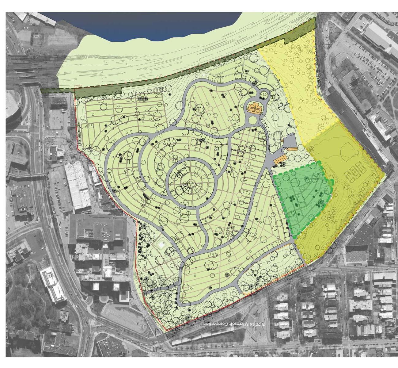
The Woodlands Landscape Character
Neighborhood Welcome Landscape
Hamilton Estate Landscape

New Cemetery Landscape
Price Era Landscape
Woodland Garden / The Dell
Long Meadow Landscape
Working Landscape
Victorian Elaboration
Arrival Landscape

CHESTER AVENUE WOODLANDAVENUE 42ND STREET UNIVERSITY AVENUE
BALTIMORE AVENUE
Zone 1: Neighborhood Welcome Landscape
With the development of the Cemetery, this section of the property was designated as a buffer and was not included in the layout of the cemetery sections for use as burial plots. This function as a buffer has continued, and today supports passive recreational uses by neighbors and visitors, and active recreational uses as part of a lease agreement with neighboring University of the Sciences in Philadelphia (USP). It also supports program uses for festivals like the Go West! Craft Fest. The Master Plan recommends enhancements to the landscape, including temporal art installations and furnishings, that invite neighbors and passersby to come through the gate, linger on the lawn or under the canopy of trees, and to explore the property that lies beyond.
The landscape character here is one of large trees and sweeping lawns. It can be enhanced with swaths of spring ephemerals within the lawn. Select areas of ground cover can be added and also enhanced with bulbs. Care should be taken to preserve enough area for festivals and other events or installations; and mowing regimes will need to be altered for survival of spring bulbs. Shrubs used within this area will be limited to preserve long views into the site.
Streetside, the fence and brick sidewalk will be restored and new street trees introduced to enhance the presentation of The Woodlands along Woodland Avenue. Where the street planting strip is underwire, use smaller flowering trees like Cercis Canadensis (Redbud), Hawthorne and Amelanchier canadensis, Shadblow Serviceberry.
48 WOODLANDS CONNECTS
Zone 2: Hamilton Estate Landscape
The Master Plan recommends elimination of the vehicular roads between the Mansion and the Stable to create a pedestrian zone and garden setting that is evocative of the Hamilton era. This includes incorporation of the currently leased and heavily wooded area to the south and west of the Mansion - “the Hamilton Woods” - which was never developed as part of the Cemetery; and, selective modification of the cemetery-era grading surrounding the Mansion to suggest the Hamilton era relationship of the house to the landscape vis-à-vis the restored Cryptoporticus and its connection to a sunken walk leading to the Stable.

In designing this area, it is important to remember the vast extent of Hamilton’s gardens and huge variety of plants. By 1795, Hamilton had completed all the major features of his horticultural showplace including a nursery, massive greenhouse, two hothouses, kitchen garden, ice house and orchard, lawn, statuary and, of course, manicured flowerbeds in the English style. At its peak, Hamilton’s plant collection included about 10,000 species of plants from all over the globe; Hamilton claimed that “there was not a rare plant in Europe, Asia, Africa, from China and the islands in the South Sea, of which he had any account, which he had not procured.” While matching Hamilton’s collection is not an attainable goal, these gardens will be developed to recall the Hamilton Era and its rich botanical history.
Zone 3: Section K, “Woodlands Memorial Garden”
Taking cues from Mt Auburn Cemetery’s Birch Gardens, Section K will be transformed into a new contemplative garden and burial area. The garden is developed into a series of naturalized rooms with a variety of planting styles including lawns under stately large trees, meadows, bosques, and allées woven together by a matrix of flowering understory trees. As it is developed it may include pools, fountains, or other small water features. Benches and chairs are located throughout, providing places for reflection and contemplation. Here one will find traditional and alternative burial styles including casket, urn, and cremated remains without an urn. This garden includes individual markers, upright monuments, markers in turf and other groundcovers, small labels on nearby trees or shrubs, and other alternative areas for remembrance like low walls, benches, or no marking at all.
Zone 4: Price Era Landscape
In 1840 Eli K Price and a few others took control of the estate and founded the Woodlands Cemetery Company of Philadelphia. This decision was part of a larger movement to encourage a cultural transition from the overcrowded and unsanitary churchyards of the eighteenth century to green, park-like cemeteries. The cemetery’s goal was that “the beautiful landscape and scenery of that situation [Hamilton’s estate] may be perpetually preserved,” rescuing the site from imminent industrial use and the later residential development of West Philadelphia’s “streetcar suburb.” Hamilton’s cultivated landscape was transformed into a “rural cemetery,” with winding carriage-ways and highly individualized monuments. Price developed a new landscape plan which has been lost, but the records of plant purchases remain. Research is needed to fully develop a plan based on the best knowledge of the Price Era landscape. We know that thousands of evergreens were planted among existing species to enhance the setting and thick planted thorn hedge buffers were developed to block out undesirable views. Today, buffers are still necessary and new planting plans can be use to evoke Price Era buffers.
Zone 5: Section M, “The Dell”
This new woodland garden is intended for those who love our native woodlands and cherish the natural world. It is set within a sculpted bowl under a cathedral of trees and will nurture a bird habitat. Flowering shrub mounds and rich ground covers surround the intimate woodland walking trails woven throughout. The garden is framed by a stone amphitheater, three beautiful existing mausoleums, and a new memorial wall running along the east side of the garden. In addition to the stone memorial wall, a buffer of evergreen trees and shrubs will be used to screen the VA Medical Center service drive and reduce erosion. Negotiations with the Medical Center will be necessary to fully develop the buffer. The amphitheater and wall include panels for memorialization. Like Section K, throughout the wooded dell there are myriad ways to memorialize loved ones including small personalized inscription markers, markers in groundcover, small labels on nearby trees or shrubs, and benches. The amphitheater also provides a new venue for events like concerts, book readings and other performances.
Zone 7: Working Landscape
The working landscape is made up of an orchard and community garden plots adjacent to a new maintenance building and service yard. It takes advantage of the sunny top of slope location, proximity to the new parking lot, and neighborhood access from an existing site gateway. Although the land has been filled here since Hamilton’s time, there is supposition that this was the vicinity of his orchard and kitchen garden, and thus these uses have some historic precedence. There is ample land and sunlight at this location to grow the current community gardening program. The orchard represents another community amenity and an opportunity for partnership with The Philadelphia Orchard Project.
A buffer at the western edge of the area is used to screen adjacent views and possibly frame new views to the river. This buffer will be a lower hedgerow so as not to shade the adjacent farm land.
The service yard will have an area to house materials like soil, compost, and mulch necessary for site and cemetery maintenance and community garden use. There is partnership potential with The Dirt Factory, a University City community composting facility that keeps fallen leaves out of the waste stream, and composts food scraps and other organic waste. Composted materials from the community and the site will support on-site and local gardening. The maintenance building can offer office and workshop spaces for this or other like-minded organizations.
Zone 8: Victorian Elaboration
The Victorian elaboration zone will transport visitors back to the Era in which cemeteries were oft visited and lovingly cared for by family members of the deceased. This area will be transformed with lushly planted plots using the height of the romantic plantings the Victorian’s favored including hydrangea, roses, geranium, campanula, phlox, clematis, delphinium, and other plants listed in the sources used by Price, such as the garden manuals of J.C. Loudon. Restoration and reproductions of selected missing boundary fences will provide additional context to this section of the cemetery, and a framework for interpretation of the garden cemetery. To start the transformation, The Woodlands will host a cradle grave competition for the installation and care of the first plots.
Zone 6: Long Meadow Landscape
This area is the first area on site to be transformed into a long lawn more evocative of both the Hamilton era and early cemetery maintenance. The longer term goal is to allow and plan for longer grass to grow in most of the cemetery; planning will also include interpretive signage and educational programs to explain both the historic precedent and the longterm and sustainable benefits from alternative maintenance methods.
The grass here will be 6”-12” high and can include swaths of spring bulbs and shorter summer flowers. Not only will this reduce mowing costs, but perhaps more importantly, it will yield larger stretches of quiet to this gently sloping area where one already feels removed from the hustle of the city.
Zone 9: Arrival Landscape
For the arrival zone, a palette of indicator plants, mostly trees is important. These selections will help guide the visitor through the site from the entry drive to drop-off at the new Stable and parking facilities. It should also cue visitors on how to circulate from the parking lot to the Stable and related event spaces. This is not to suggest formal allées, but rather, single and groves of trees that make passage evident.
WOODLANDS CONNECTS 49
Character-defining images and plants from the Hamilton-era and Price-era landscapes


Top row (l-r): Arrival landscape and remnant of the Hamilton Carriage Road (HALS PA-5-7, 2003); Hamilton seed packet (collection of The Woodlands at the Academy of Natural Sciences); Mount Moriah Cemetery (unknown stereoview); Lt. Greble’s Monument, Woodlands Cemetery (Philadelphia and Its Environs, Pierson,1875)
Middle row (l-r): View of Botanic Garden at Elgin (Simond, 1810); Botanical prints of plants mentioned in Hamilton’s letters; Cradle Graves at The Woodlands


Bottom row (l-r): Corner of the orchard and nursery at Monticello (Burford); Hydrangea mutabilis; Williamsburg kitchen garden; Zelkova crenata; Lombardy poplar (Populus nigra Italica); Moore Monument, Woodlands Cemetery (Sartain, 1868)
50 WOODLANDS CONNECTS


CIRCULATION STRATEGIES - ROADWAYS


Circulation at The Woodlands has changed from the original country road that once led from the entry lodges at the north east corner, across the scenic topography of Middle Run, and toward the Mansion along the edge of Hamilton’s Park Lawn. The development of the estate by the Cemetery Company required a comparatively extensive network of cart-ways to provide and service interments on the property.
Today, most of the core plots within the center of the Cemetery have been filled; and, the plots that remain are either individually scattered throughout the densely developed sections towards the center, or are concentrated in sections at the periphery. The less intensive use for burials throughout the center sections presents new opportunities to change the circulation through The Woodlands and enhance the landscape character and experience. There are currently approximately 1.5 miles of road that make up the Cemetery road system, most of which is rarely needed for access for interments or for visitors. The extensive road system creates confusion for visitors arriving by car, and allows for unwanted circulation and access by unauthorized vendors or service personnel from neighboring properties. The relocation of the main entry gate in the 1920s to its current location introduces and connects visitors to the circulation system at a location that provides no obvious landscape cues, or obvious choices to direct visitors when they arrive.
Reduce and limit vehicle circulation to a one-way loop road to control flow and lead visitors to a clear arrival point at the Stable and Hamilton Estate landscape zone:
• Enhances landscape character
• Follows along the path of the original carriage road leading to the Mansion
• Access roads can be made available for scheduled interments, family visits, and authorized maintenance
Selectively remove road paving (retain Cemetery era curbs) to create pedestrian only zones:
• A short section of Mansion Avenue within the historic core between Stable and Mansion (Phase 1)
• Mansion Circle and Elm Avenue located east and south of the Mansion (Phase 2)


• A section of West Gate Avenue (Phase 2)

• Paving changes will be pedestrian-friendly and appropriate for intermittent maintenance and emergency access
• Paving changes may include stone dust or other stabilized aggregate and lawn
Create a new road alignment around Section K that extends Maple Avenue and the one-way loop; and, leads visitors to a new parking area and provides access for service personnel to a new maintenance and service area.

52 WOODLANDS CONNECTS


The Woodlands Circulation One-way loop road One-way loop road (Phase 1); Pedestrian paving (Phase 2) Convert to pedestrian paving BALTIMORE AVENUE CHESTER AVENUE WOODLANDAVENUE 42ND STREET UNIVERSITY AVENUE MAPLE AVE MANSION AVE CEDAR AVE OAK AVE CENTRE CIRCLE AVE VAULT AVE CYPRESS AVE ELM AVE MAGNOLIA AVE LARCH AVE HAMILTON AVE MANSION CIRCLE WEST GATE AVE MANSION AVE MAPLE AVE
CIRCULATION STRATEGIES - TRAILS & PATHS
Multi-Use / Bicycle Trail
The project analyzed potential bicycle trail routes through The Woodlands to be used for both recreation and as a commuter asset. Potential routes included: (1) using the southern perimeter of the property, from University Avenue to approximately 42nd Street, located just north of the Amtrak/SEPTA/CSX railroad tracks and the Schuylkill riverfront, and above a Philadelphia Water Department (PWD) utility right-of-way; and, alternatively, (2) using existing cemetery roads that lead from the entry gate towards the PWD right-of-way at University Avenue. The proposed route (see facing page) takes advantage of the existing cemetery road system and the traffic calming measures proposed with the one-way loop road (see previous page). The route creates a short section of shared roadway where bicyclists headed south from the entry gate would follow the one-way vehicle route and bicyclists headed north on this section would have a designated bike lane. A two-way trail then continues south along the existing cemetery road, which will be closed to vehicle traffic, and along a new section of trail along the eastern edge of the property. An agreement with the Philadelphia Water Department and the VA Medical Center will be needed to construct a trail section along the southern boundary of the VA property and within the Water Department’s utility right-of-way. The trail design is consistent with PennDOT and AASHTO guidelines for minimum width for one- and two-way bicycle facilities.
Walking and Jogging Trail
Many of the existing users come to The Woodlands to experience the peaceful quality of the landscape at the perimeter of the property. An informal earthen trail has been created through consistent use over the years and measures approximately one mile. As portions of the currently leased land are re-appropriated, the trail can connect these non-cemetery landscapes and uses as part of the circuit, and will extend the total length to approximately 1.1 miles. Proposed improvements include a stabilized surface (porous paving) and stormwater management (see Stormwater Strategies).
Hamilton Circuit Walk
Road removals within the historic core will refocus this section of the landscape into a more garden-like setting that is representative of Hamilton’s estate. The reintroduction of landscaped gardens will provide the Mansion, Stable, and Carriage Shed area with a character that will benefit both interpretive programming and rental events. Hamilton’s landscape in effect had two circuit walks for visitors, one for the “Park Side” (north) of the house and one for the “Garden Side” (south). The two walks were separated by fencing and mutually exclusive. The circuits are described in Drayton’s journal, the letter from L.G. to Eliza, and hints of the garden circuit are seen in paintings by Groombridge and Malcom. A new circuit walk will provide an opportunity to create a more intimate experience around the Hamilton buildings, connect to the wooded area to the south and west - “the Hamilton Woods” - that was never developed as part of the cemetery, and to reintroduce unique plants to the site that were previously cultivated here by Hamilton.
54 WOODLANDS CONNECTS
The Woodlands Circulation
AVENUE CHESTER AVENUE WOODLANDAVENUE 42ND STREET UNIVERSITY AVENUE Multi-use / Bicycle Trail Walking and Jogging Trail Hamilton Circuit Walk
BALTIMORE
TREE PLANTING STRATEGIES
VIEWS
View zones should be preserved and enhanced by:
• Limiting or restricting planting within identified view zones and important vistas
• Clearing and pruning vegetation that has obstructed views
• Reinforcing vistas with buffer plantings and specially selected plants and trees to strengthen desirable views and deemphasize or screen visual distractions
• Protecting open space within view zones with buffer plantings to reinforce the enclosure, and provide definition of these spaces
Existing views and vistas that should be preserved and enhanced:
• View from Mansion portico towards the river
• Views between the Mansion and the Stable
• View to Mansion from Section F axial walk
• View to Mansion from Section N
View opportunities:
• View across the landscape from higher elevation at the proposed new pedestrian entrance from Penn’s “Woodland Walk” at the north east corner of the property. This location is near Hamilton’s original carriage road entrance to the estate.
• View of skyline from Center Circle.
• View of Schuylkill River from proposed new overlook at the McDaniel Mausoleum
WHERE TO PLANT
• Buffer locations identified on Master Plan

• Locations where large trees have been lost; and, to strengthen areas that have been diminished by attrition between 2001 - 2014 as documented in the Tree Inventory
WHERE NOT TO PLANT
• Keep view zones and view opportunities clear
• Respect boundaries of burial plots
• Within changes to roads, paths, and new alignments
WHAT TO PLANT
• Trees that are scion or otherwise descendants of significant trees on site
• Trees identified in the Hamilton Plant lists and the Price Era plant lists
• Native trees to recall the landscape of a bygone era, especially at buffers
• Deciduous trees that do not interfere with viewsheds
WHAT NOT TO PLANT
• Large trees within grave sites, unless replacing known significant trees
• Invasive trees
• Evergreen trees within viewsheds
56 WOODLANDS CONNECTS
The Woodlands View Zones

Existing Views and View Opportunities

View Zones where views should be preserved and/or enhanced by limiting or restricting planting in these zones

TREE PLANTING STRATEGIES
BUFFERS
Densely planted borders and edges sometimes in combination with screen walls or fences, are proposed at the following locations (in priority order):
Enhance jogging/walking path and new bike path experience (Phase 1):
• East property line to screen service areas of VA Medical Center along Oak Avenue (Section G/H) at narrow strip between curb line and property line fence.
• East property line, in combination with a buffer fence, to screen service areas of VA Medical Center along the proposed new bike path section at the south east corner of the property.
• South property line along rail edge to carefully and selectively screen rail line infrastructure below eye level but to maintain, frame, and enhance unobstructed views upstream and downstream. The Woodlands will continue to work with CSX railroad to maintain visual clearance on the rail property.

Enhance views from Carriage Shed event space and improve landscape setting for passive recreation and jogging/walking path (Phase 1):
• West property line, in combination with meadow planting, to screen the University of the Sciences in Philadelphia (USP) structures located immediately adjacent to The Woodlands property.

• Possible views to the rivers should be studied here.
Enhance active burial areas for Cemetery use and improve landscape settings (Phase 2):
• East property line, in combination with a stone memorial wall, to screen service drive at the VA Medical Center at Section M and reduce erosion. This area will include large numbers of evergreens.
• Selective planting around Section K to establish “Garden Room” structure.

58 WOODLANDS CONNECTS
Views of Existing Conditions Along East Property Line and VA Medical Center
BUFFERS
Screen proposed new maintenance building, service yard, and parking from new road alignment (Phase 2):
• Selective tree and shrub planting along the proposed new road alignment and vehicular circulation to screen the parking lot and service yard.
• A low hedgerow style planting at the Western buffer will be sympathetic with the working landscape located here. The plantings could be selected to include edibles to merge with the community garden and orchard, to attract pollinators for crops in the working landscape, and to serve as a wildlife corridor.
Buffer plantings should include a mix of deciduous/evergreen trees and shrubs:
• Native buffer plantings will suggest the landscape of a past era.
• Densely screen unsightly service areas at eye level, but allow view of the skyline above where present.

• Buffers should have multiple layers to allow for as thick a screen as permissible by grave placements and other restrictions. Multi-layered vegetation makes a better buffer for visual interest and screening capacity. If one tree or shrub dies, there are others to take over.
• Tree selection should be based on medium species height of 40’-50’ and medium density.
• Buffers should be a mixture of evergreens and deciduous trees (minimum 60% evergreen).
• Buffers might include Ilex Opaca, Juniperus virginia, Ilex glabra, Ilex verticillata, Viburnum varieties, Cercis canadensis, Dogwood, Sourwood, and Cherry Laurel.

WOODLANDS CONNECTS 59
Views of Existing Conditions Along West Property Line and the University of the Sciences of Philadelphia
LIGHTING STRATEGIES
The Woodlands is, and will continue to be, a dawn-to-dusk site for public access. New programming and events, however, will require some level of lighting for site users to safely navigate to the buildings and event locations from parking areas.

There is also an interest in creating a nighttime presence for two major architectural features: the south portico of Hamilton Mansion facing the river (visible from the University Avenue bridge, from the Grays Ferry Crescent section of the Schuylkill River Trail, and from commuter trains) and the Paul Cret Entry Gates facing Woodland Avenue.

Lighting recommendations (lighting levels, effects, fixture types, and controls) are included in the phased implementation plans and budgets for the following areas:
Hamilton Mansion Portico: Small floodlights are proposed to light the interior of the portico to draw attention from a distance.


Woodland Avenue Entry Gate: LED uplights and linear downlights are proposed to light the engraved lettering on the masonry lodge structures as well as the curved flanking walls.

Nodal points throughout the cemetery for vehicle navigation during and after events: Multi-luminaire poles are proposed at nodal points along the vehicular path to create small areas of illumination on the road surface and of surrounding landscape and cemetery features.

Carriage Shed: Accent lights mounted under wall capstones and uplight for trees to create an outdoor room at night.

Landscaped areas adjacent to the buildings and parking lot: Low level and ground mounted path lighting and tree lighting.

60 WOODLANDS CONNECTS
STORMWATER STRATEGIES


With the exception of some areas along the walking and jogging trail, stormwater is managed well at the Woodlands. The road has an existing and conventional system of small inlets that may not be entirely connected to a large-scale stormwater management system and may infiltrate locally in some sections or drain towards the river.
The historic approach, which continues today, of managing stormwater where it falls should be employed in any development at the site. There are a few select wet areas along the walking and jogging trail especially at the south edge of Section N. Here the trail will be designed to “bridge” the wet areas. Trail building techniques from high mountain trails like the Adirondack Trail System will be employed. These might include water bars, dips, underdrains, or small wet depressions and swales to move water off the trail; or, even trail relocation to move the trail off the wet points.
All new impervious surfaces will require that the first 1-inch of runoff is managed. On this site, in areas of limited surface area for bioretention or other surface management features, porous pavements or subsurface infiltration beds beneath standard pavement will offer the most efficient solution. This includes walking trails, driveways, and parking areas. Due to materials storage, the proposed new maintenance service yard will be impervious to avoid clogging. However, as this area includes new planted buffers, some vegetative stormwater management can be employed in lieu of or in addition to underground infiltration beds.
In areas of vegetation management, Section M and the new Hamilton Woods, selective vegetation management should be practiced to preserve healthy trees for stormwater management and obvious aesthetic reasons.
Where ever feasible, moving from tightly mown lawns to high lawn grass or meadows will benefit overall stormwater management even if it does not count toward managing new impervious surfaces. At Woodland Avenue, through the addition of ‘planted bump-outs’ flanking the entrance gate, some stormwater management may be possible in partnership with the city and the Philadelphia Water Department. This area can serve not only for stormwater, but to enhance the look and feel of the main entrance through the narrowing of Woodland Ave and the addition of street trees and other plantings.
WOODLANDS CONNECTS 61
MASTER PLAN STAGE 1 IMPROVEMENTS & INFRASTRUCTURE
HISTORIC CORE
• Carriage Shed improvements
• Regrading on Mansion east side (access to Cryptoporticus)
• Hamilton Circuit Walk
PRIMARY ENTRANCE GATE
• Lighting and signage
• Woodland Avenue crosswalk
PEDESTRIAN CIRCULATION
• Recreation trail improvements (35% of total length)
VEHICULAR CIRCULATION
• Entrance road improvements
• Street paving repairs
• Vehicle drop-off at Historic Core
BICYCLE PATH
• Connect to University Avenue
LANDSCAPE & BUFFER IMPROVEMENTS
• Improvements along Woodland Avenue and within the Hamilton Estate, Long Meadow, and Arrival Landscape zones
STRUCTURE & FACILITY IMPROVEMENTS
• Relocate Mansion offices and selected system upgrades to make first floor available for program and event rental
• Mansion and Stable exterior restoration
LANDSCAPE MAINTENANCE
• Woodland Avenue sidewalk and fence repairs
UTILITY IMPROVEMENTS
• Site lighting along vehicle drive from Entry Gate to Stable
• Sewer connection
OPPORTUNITIES
• Undertake early, low-cost, high impact improvements to increase visibility and income generation
• Develop relationship with partner organization with space sharing and/or partial land use agreement
IMMEDIATE ACTION ITEMS
• Tree care and invasives management
• Monument repair program
• Tree survey and tree tag replacement
• Selective cemetery path repair
ADDITIONAL PLANNING ITEMS
• Site features and topographic survey
• Archaeological research and planning
• Cemetery Section K rectified survey
• Cemetery records database development

62 WOODLANDS CONNECTS


The Woodlands Stage 1 BALTIMORE AVENUE CHESTER AVENUE WOODLANDAVENUE 42ND STREET UNIVERSITY AVENUE Vehicular Circulation Pedestrian Circulation Joggin/Walking Path Hamilton Walk Bicycle Path Closed Roads Pedestrian-Only Pavement Removal Meadow Primary Entrance Secondary Entrance Tertiary Entrance Buffer Planting Buffer Fence Stone Memorial Wall Buffer Overlook Occupied, Reserved Plots (Section K) Lease Line Seasonal Performance Area MAPLE AVE MANSION AVE CEDAR AVE OAK AVE CENTRE CIRCLE AVE VAULT AVE CYPRESS AVE ELM AVE MAGNOLIA AVE LARCH AVE HAMILTON AVE MANSION CIRCLE WEST GATE AVE MANSION AVE
MASTER PLAN STAGE 2 GROWTH & ELABORATION
HISTORIC CORE
• Carriage Shed event and concessions facility
PEDESTRIAN CIRCULATION
• Woodland Walk entrance to Section M
• Recreation trail improvements (65% of total length)
• Hamilton Circuit Walk and Cryptoporticus path to Stable
VEHICULAR CIRCULATION
• Ring road and parking including new road alignment, parking lot, walking path, and lighting
• Street paving repairs
LANDSCAPE & BUFFER IMPROVEMENTS
• Buffer fence and planting
• Improvements along Woodland Avenue and within the Price Era Cemetery, Long Meadow, and Center Circle/Victorian Garden zones
STRUCTURE & FACILITY IMPROVEMENTS
• Stable event and program spaces, including new building systems, restrooms, and utility upgrades from street
• Maintenance building, service yard, and working landscape including pre-engineered shed, utilities, community garden, and pedestrian entrance to garden
• Mansion staff restroom and operations office
• Mansion HVAC upgrades
• Stable program space and HVAC upgrades
CEMETERY SECTION IMPROVEMENTS
• Section K and Section M improvements to provide options for alternative interments
OPPORTUNITIES
• Expand capacity for programming, event rentals, and income generation
ADDITIONAL PLANNING ITEMS
• Site features and topographic survey

• Archaeological research and planning
• Cemetery Section K rectified survey
• Cemetery records database development
64 WOODLANDS CONNECTS
Secondary

BALTIMORE AVENUE CHESTER AVENUE WOODLANDAVENUE 42ND STREET UNIVERSITY AVENUE MAPLE AVE MANSION AVE CEDAR AVE OAK AVE CENTRE CIRCLE AVE VAULT AVE CYPRESS AVE ELM AVE MAGNOLIA AVE LARCH AVE HAMILTON AVE MANSION CIRCLE WEST GATE AVE MANSION AVE MAPLE AVE Vehicular Circulation Pedestrian Circulation Joggin/Walking Path Hamilton Walk Bicycle Path Closed Roads
Removal Meadow
Entrance
The Woodlands Stage 2
Pedestrian-Only Pavement
Primary
Entrance
Entrance
Planting
Fence
Memorial Wall Buffer
Tertiary
Buffer
Buffer
Stone
Overlook
Line Seasonal Performance Area
Occupied, Reserved Plots (Section K) Lease
MASTER PLAN - STUDY AREA: ENTRY GATE

KEYED NOTES
Curb bump-outs
Cobble or brick to slow traffic and define entrance
Replant and/or use large containers to frame entry gate


Shared lane (sharrow symbol)
Large planted containers to direct traffic flow

Bike lane
Crosswalk
Cobble or brick band to direct traffic flow

Pedestrian signage
Bollard and chain automobile traffic
LEGEND
Jogging / walking path
Bike lane
Cobble

Cobble or brick edge band
Pedestrian signage
Flowering tree
Deciduous tree
Evergreen tree

Plant bed
Lawn Stabilized stone dust

66 WOODLANDS CONNECTS
Bottom row: Willow design by Judith Needham
1 2 3 4 5 6 7 8 9 10
WOODLAND AVENUE


40TH STREET SEPTA TROLLEY PORTAL

Entry Gate
A mid-block high-visibility crosswalk at this location will safely link thousands of commuters, trolley portal users, and visitors directly to The Woodlands front door and strengthen the visibility of the The Woodlands entry gates.
Stormwater bump-outs can help to define the entrance and crosswalk, and safely relocate idling portal passenger pickup vehicles away from entry and egress traffic at the entry gate. The portal is also an ideal location for the City’s new Bike Share program.

68 WOODLANDS CONNECTS

MASTER PLAN - STUDY AREA: BIKE PATH CONNECTION


KEYED NOTES

Entry gate with stone piers and wing walls
Cobble or brick to slow traffic and define entrance
Asphalt bike lane with retaining walls

Asphalt bike lane
Opaque buffer fence


Buffer plantings
Property fence

LEGEND
Jogging / walking path
Bike lane
Cobble

Cobble or brick edge band
Pedestrian signage
Flowering tree
Deciduous tree

Evergreen tree
Plant bed
Lawn
Stabilized stone dust
70 WOODLANDS CONNECTS
1 2 3 4 5 6 7
Top row: Paul Philippe Cret, Architect and Stephen H. Noyes, Engineer, University Avenue Bridge, 1930


UNIVERSITY AVENUE
MASTER PLAN - STUDY AREA: SECTION K
Middle
KEYED NOTES
Remove asphalt, add lawn margins and brick walk
Restore brick walk covered by grass
Add brick walk
Garden room with new plantings and seating
Garden room with brick overlook and plantings
Garden rooms with plantings and seating
Garden room

Ring road buffer plantings


Ring road
LEGEND
Jogging / walking path

Bike lane
Cobble
Cobble or brick edge band
Pedestrian signage
Flowering tree

Deciduous tree
Evergreen tree

Plant bed
Lawn

Stabilized stone dust
Occupied or reserved cemetery plots
Existing brick paths
Uncover existing brick paths
New brick paths

72 WOODLANDS CONNECTS
1 2 3 4 5 6 7 8 9
Top row: Stephen Stimson Associates Landscape Architects, Greenwich Garden; Reed Hilderbrand Associates, Inc., Maple Avenue, Mount Auburn Cemetery
row: Mount Cuba; unknown; Maple Avenue, Mount Auburn
Bottom row: Schwartz Smith Meyer Landscape Architects, Inc. and PWP Landscape Architecture, Village of Yorkville Park; Kew Gardens


Section K - Woodlands Memorial Gardens
The Master Plan envisions Section K as a series of “garden rooms” for meditation and reflection and can accommodate a range of interment options including traditional earth burials, cremated remains, scatter gardens, and possibly green (or natural) burials.

WOODLANDS CONNECTS 75
MASTER PLAN - STUDY AREA: HISTORIC CORE
KEYED NOTES
Turn-around with planted island
Ring road with 60 car parking lot
Exposed aggregate concrete path
Stabilized stone dust walk
Paver carpets
Restore brick as needed
Stone tiered seating with plant beds
Stabilized stone wall


Elaborate planting beds: Hamilton Era


Cryptoporticus walk
Great Lawn for events
Meadow
Jogging/walking path; porous asphalt
Stairs and ramp
Stable
Hamilton Mansion
Carriage Yard event space
LEGEND
Jogging / walking path
Bike lane
Cobble

Cobble or brick edge band

Pedestrian signage
Flowering tree

Deciduous tree
Evergreen tree
Plant bed
Lawn
Stabilized stone dust
76 WOODLANDS CONNECTS
1 2 3 4 5 6 7 8 9 10
12 13 14 15
11
16 17
Top row: Jardin du Luxembourg


Visitor Arrival
Vehicle circulation at The Woodlands will be reconfigured to create a one-way loop road to control flow and lead visitors to a clear arrival point at the Stable and Hamilton Estate landscape zone. The proposed route follows the path of the original carriage road leading to the Mansion and allows the area between the Mansion and Stable to be dedicated as a pedestrian-only zone.

WOODLANDS CONNECTS 79
The Carriage Shed Event Space
Reuse of the Carriage Shed will create a picturesque setting within the Historic Core that has ample room for large 300+ programs and events, either tented or open-air, that can be supported by indoor facilities at the Stable including multi-purpose program space and restrooms. A roofed and sheltered space at the perimeter of the Carriage Shed can accommodate infrastructure for concessions and catering equipment.
 80 WOODLANDS CONNECTS

MASTER PLAN - STUDY AREA: THE DELL (SECTION M)
1 2 3 4 5 6 7 8
KEYED NOTES
Entry gate with stone piers and wing walls
3’-4’ memorial wall with railing and steps into memorial grove
Stone amphitheater with stone pavement and overlook wall

Woodland garden beneath existing and new trees

6’ memorial wall
Memorial overlook with stone walls and paving
Jogging/walking path
Existing mausoleums
LEGEND
Jogging / walking path

Bike lane
Cobble
Cobble or brick edge band
Pedestrian signage
Flowering tree
Deciduous tree

Evergreen tree
Plant bed

Lawn
Stabilized stone dust
Top row: Woodlands Cemetery (HALS PA-5-5); unknown

Middle row: Evergreen Cemetery, VA; Jensen’s Council Ring (painting), Yelena Klairmont; unknown


Bottom row: Scott Outdoor Amphitheater, Swarthmore College; unknown; Spruce Knoll, Mount Auburn Cemetery

82 WOODLANDS CONNECTS
40TH STREET SEPTA TROLLEY PORTAL
WOODLANDAVENUE


VAMEDICAL CENTER DRIVEWAY


The Dell Memorial Garden
The terrain and tree canopy of Section M is re-imagined as a woodland grove, or dell, that recalls the Middle Run valley near this location. A new pedestrian entrance at the north east corner of Section M, near the original entrance lodge location, will provide a natural terminus or starting point for Woodland Walk, which cuts diagonally through the University of Pennsylvania campus along the historic alignment of Woodland Avenue, and creates easy access for students and University employees to the peaceful setting of The Dell.

WOODLANDS CONNECTS 85
MASTER PLAN - STUDY AREA: VICTORIAN GARDEN


86 WOODLANDS CONNECTS
Victorian Garden at Center Circle
The Victorian Garden will transport visitors back to the Era in which cemeteries were oft visited and lovingly cared for by family members of the deceased. This area will be transformed with lushly planted plots using the height of the romantic plantings the Victorian’s favored including hydrangea, roses, geranium, campanula, phlox, clematis, delphinium, and other plants listed in the sources used by Price, such as the garden manuals of J.C. Loudon. Restoration and reproductions of selected missing boundary fences will provide additional context to this section of the cemetery, and a framework for interpretation of the garden cemetery.
 WOODLANDS CONNECTS
87
Top row: Sacramento Historic City Cemetery; Highgate Cemetery
Middle row: Victorian Cradle Grave Illustration (The Stranger’s Guide in Philadelphia and Its Environs, 1854)
PHASING & IMPLEMENTATION
PHASE 1 - YEARS 1 THROUGH 5
Phase 1 projects focus on improvements and infrastructure that will support and help to develop opportunities for income generation.
The costs presented for all phases are budgets for estimated construction costs, and do not include design, engineering, legal or insurance fees, permits, staffing expenses, or escalation for inflation adjustments.
For each itemized project, total project costs can vary depending on the size of the project and for site work compared with building restoration projects. Project costs for site work may include an additional 15-20%, and for building restoration projects, an additional 25-35%.
Where project labor can be reasonably supported by professionally supervised volunteers, the word “Volunteer” appears in the “Cost” column. The cost is the budget based on estimated construction costs without volunteer labor.
EASY / LOW COST / HIGH IMPACT
PROJECTCOST HISTORIC CORE
Carriage Shed Improvements$63,000
VEHICULAR CIRCULATION
Entrance Road Improvements$39,000
LANDSCAPE & BUFFER IMPROVEMENTS
HIGH IMPACT / INCREASE VISBILITY / SUPPORT INCOME GENERATION & PROGRAMS
PROJECTCOST STRUCTURE & FACILITY IMPROVEMENTS
Mansion & Stable Exterior Restoration $764,000 Mansion System Upgrades$153,000
BICYCLE PATH
Connect to University Avenue$338,000
PHASE TOTAL$2,879,000
Zone 1 Improvements
Woodland Avenue Volunteer
Plantings & furnishings inside fence
PRIMARY ENTRY GATE
Lighting and Signage$18,000
Zone 2 Improvements
Hamilton Zone $18,000
Open leased land to recreational use
STRUCTURE & FACILITY IMPROVEMENTS
Relocate Mansion Offices$25,000
First floor available for program & event rental
LANDSCAPE MAINTENANCE
Woodland Avenue sidewalk (outside fence) and fence repairs
$33,000
CATEGORY SUBTOTAL$145,000
CATEGORY SUBTOTAL$1,306,000
88 WOODLANDS CONNECTS
INFRASTRUCTURE PROJECTCOST UTILITY IMPROVEMENTS Site Lighting$123,000 Vehicle drive (Entry Gate to Stable) Septic System - Municipal Connection ** $100,000 New Water Service Connection$10,000 PEDESTRIAN CIRCULATION Recreation Trail Improvements$114,000 35% of trail length PRIMARY ENTRY GATE Woodland Avenue Crosswalk$154,000 VEHICULAR CIRCULATION Street Paving Repairs Allowance$30,000 ENHANCEMENT PROJECTS PROJECTCOST VEHICULAR CIRCULATION Vehicle Drop-Off at Historic Core$53,000 HISTORIC CORE Regrading on Mansion East Side (Access to Cryptoporticus) $110,000 Hamilton Loop Walk$230,000 Remove asphalt paving in Historic Core LANDSCAPE & BUFFER IMPROVEMENTS Zone 1 Improvements Woodland Avenue Volunteer $170,000 Zone 2 Improvements Hamilton Estate / Historic Core Volunteer $244,000 Zone 6 Improvements Long Meadow (Section N) Volunteer $59,000 Zone 9 Improvements Arrival Landscape Volunteer $31,000 OPERATIONS BUDGET / MAINTENANCE ACTION ITEMS PROJECTBUDGET LANDSCAPE MAINTENANCE Tree Care & Invasives Management (5 years) $132,000 Monument Repair Budget$80,000 Years 2-5; Year 1 see Planning Projects Tree Survey & Tag ID Replacement Volunteer $3,000 PEDESTRIAN CIRCULATION Selective Cemetery Path RepairVolunteer $13,000 OPERATIONS, RESEARCH & PLANNING PROJECTS PROJECTBUDGET Action Plan for Monument Repair $10,000 Site Features & Topographic Survey $80,000 Archaeological Research & Planning Crypto Path & Privy$25,000 Greenhouse (Non-invasive)$25,000 Cemetery Section K Rectified Survey TBD Cemetery Record Database Development TBD CATEGORY SUBTOTAL$531,000CATEGORY SUBTOTAL$897,000 WOODLANDS CONNECTS 89
PHASE 2 - YEARS 3 THROUGH 10
Phase 2 and Phase 3 projects focus on growth and elaboration of the groundwork set through Phase 1.
The costs presented for all phases are budgets for estimated construction costs, and do not include design, engineering, legal or insurance fees, permits, staffing expenses, or escalation for inflation adjustments.
For each itemized project, total project costs can vary depending on the size of the project and for site work compared with building restoration projects. Project costs for site work may include an additional 15-20%, and for building restoration projects, an additional 25-35%.
Where project labor can be reasonably supported by professionally supervised volunteers, the word “Volunteer” appears in the “Cost” column. The cost is the budget based on estimated construction costs without volunteer labor.
HIGH IMPACT / INCREASE VISBILITY / SUPPORT INCOME GENERATION & PROGRAMS PROJECTCOST HISTORIC CORE Carriage Shed Event & Concessions Facility $1,827,000 STRUCTURE & FACILITY IMPROVEMENTS Stable Event & Program Space Stable Building Systems, Restrooms $299,000 Utility Upgrades from Street$476,000 CEMETERY SECTION IMPROVEMENTS Section K$427,000 Section M$654,000 PEDESTRIAN CIRCULATION Woodland Walk Entrance to Section M $33,000
CATEGORY SUBTOTAL$3,716,000 PHASE TOTAL$6,746,000 PHASE 3 - YEARS 10 + PHASE TOTAL$806,000 90 WOODLANDS CONNECTS
INFRASTRUCTURE PROJECTCOST VEHICULAR CIRCULATION Ring Road & Parking$856,000 New road, parking, walking path, lighting Street Paving Repairs Allowance$30,000 STRUCTURE & FACILITY IMPROVEMENTS Maintenance Building / Service Yard / Working Landscape $604,000 Pre-engineered shed, utilities, community garden, pedestrian entrance to garden Mansion Staff Restroom / Operations Office $64,000 LANDSCAPE & BUFFER IMPROVEMENTS Buffer Fence & Buffer Planting at VA Volunteer $186,000 PEDESTRIAN CIRCULATION Recreation Trail Improvements$325,000 65% of trail length ENHANCEMENT PROJECTS PROJECTCOST PEDESTRIAN CIRCULATION Pergola$67,000 Hamilton Loop / Crypto Walk$308,000 LANDSCAPE & BUFFER IMPROVEMENTS Zone 1 Improvements Woodland Avenue Volunteer $166,000 Zone 4 Improvements Price Era Cemetery Volunteer $175,000 Zone 6 Improvements Long Meadow (Section N) Volunteer $117,000 Zone 8 Improvements Center Circle / Victorian Garden Volunteer $132,000
BUDGET / MAINTENANCE ACTION ITEMS PROJECTBUDGET PEDESTRIAN CIRCULATION Selective Cemetery Path RepairVolunteer $33,000 CATEGORY SUBTOTAL$965,000 CATEGORY SUBTOTAL$2,065,000 INFRASTRUCTURE PROJECTCOST STRUCTURE & FACILITY IMPROVEMENTS Mansion HVAC Upgrades$656,000 Stable Program & HVAC Upgrades $150,000 CATEGORY SUBTOTAL$806,000 WOODLANDS CONNECTS 91
OPERATIONS
PHASING & IMPLEMENTATION - VOLUNTEERS


Volunteers help The Woodlands fulfill its mission to enrich the lives of area residents and visitors by serving as a hub for activities and educational programs that interpret, celebrate, and make available to the public The Woodlands’ historic buildings and tranquil green space. The Woodlands relies on volunteers for everything from historical research to leading house tours, from gardening to helping us make sure our events run smoothly. Many of the Master Plan projects can be supported with volunteer programs.

92
WOODLANDS CONNECTS
UC Green participates in a National NeighborWoods Month event at The Woodlands (Top Row, Bottom Left)
Neighbors help with plantings at the entry gate (Bottom Center)
Local students and neighbors volunteer with check-in during an event (Bottom Right)


