
www.south.is
Share your experience www.facebook.is/visitsouthiceland #southiceland


You can find more information about South Iceland in these regional tourist maps


Nature Highlights
The Golden Circle Area
The coastline between Eyrarbakki and Stokkseyri
The coastline between the rivers Þjórsá and Ölfusá (25 km/15 mi) forms the outskirt of the great Þjórsárhraun lava field. Eyrarbakki and Stokkseyri provide easy access to the coastline as well as a path between the two villages. The beach is ideal for families with kids who like to explore nature.
GPS N63°50’23.264”, W21°4’38.493”
Knarrarósviti - lighthouse
Built in 1938-1939, the lighthouse was the first one in Iceland to be built out of reinforced concrete and was, for a long time, the tallest building in South Iceland. This spot is perfect for short walks in charming natural surroundings. Knarrarósviti is part of the South Coast Lighthouse Trail. Learn more at www.south.is.
GPS N63° 49‘23.914‘, W20° 58‘33.647‘
Þingvellir - National Park
At Þingvellir the national assembly was established around 930 A.D. and continued to convene there until 1798. Many crucial events in Icelandic history took place at Þingvellir and it is at the heart of Icelandic national identity. No less remarkable is the geology of Þingvellir. Visitors can get an interpretation of the history and nature of Þingvellir and find hiking trails and camping grounds.
Þingvellir is Iceland‘s oldest National Park and now on the UNESCO World Heritage List. It is listed as a national park (since 1928) because of the special tectonic and volcanic environment. The continental drift can be clearly seen in the cracks and faults which traverse the region, the biggest one, Almannagjá, being a veritable canyon. GPS N64° 16‘ 47.504“, W21° 5‘ 17.149“
Kerið - Crater
A 55 m deep volcanic crater, about 3000 years old. It is part of a group of volcanic hills called Tjarnarhólar and it is now filled with water.
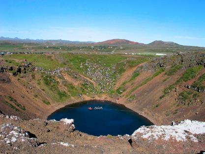

GPS N64° 2‘ 27.611“, W20° 53‘ 5.599“

Þjórsárdalur - Valley
Þjórsárdalur valley was the site of flourishing Settlement Age community that was later abandoned and then disappeared under ash in 1104, when the volcano Mount Hekla erupted for the first time in Iceland’s recorded history.


GPS N64° 7.114‘, W19° 49.325‘
Stöng and The Saga-Age Farm
Sites of about 40 buildings have been unearthed in the Þjórsárdalur valley and the best preserved and most remarkable is the farmhouse at Stöng excavated in 1939. Based upon the Stöng farmhouse a replica Saga-Age farmhouse was built in 1974 to mark the 1100th anniversary of the settlement of Iceland. Open to the public all summer. GPS
N64° 8.972‘, W19° 45.410‘
Geysir
Geysir has lent its name to the English language in order to christen the phenomenon of the periodically spouting hot springs. You can walk around the Geysir area, a geothermal field where hot springs are in abundance, geysers explode and pools of mud bubble.
Strokkur gives a performance every few minutes, shooting a tower of water and steam 30 metres into the air.

GPS N64° 18‘ 49.512“, W20° 17‘ 58.160“
Gullfoss - Waterfall

Gullfoss is actually two separate waterfalls, the upper one has a drop of 11 metres and the lower one 21 metres. The rock of the river bed was formed during an interglacial period. For thousands of years the river has followed its course delighting tourists with beauty and power.
GPS N64° 19‘ 38.220“, W20° 7‘ 8.135“
Urriðafoss – Waterfall
Urriðafoss is voluminous waterfall in Þjórsá river, where the river falls off the margin of Þjórsárhraun lava field in beautiful and peaceful surroundings. Þjórsárhraun lava field was the greatest lava flow on earth since the Ice Age. The waterfall is located right off highway number one. GPS N63° 55‘ 28.731“, W20° 40‘ 19.063“
Hekla - Volcano
One of the most famous volcanoes in the world, Hekla is believed to have erupted at least twenty times since the settlement of Iceland, and five times in the 20th century. The latest eruption was in February 2000.

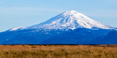
GPS N63° 59.488‘, W19° 39.901‘
Landmannalaugar - Volcano region


Landmannalaugar is a region near the volcano Hekla in the southern section of Iceland’s highlands. The area displays a number of unusual geological elements, like the multi-coloured rhyolite mountains and expansive lava fields. The mountains in the surrounding area display a wide spectrum of colours. GPS N64° 3.410’, W19° 52.176’
Sólheimajökull - Glacier

Sólheimajökull glacier flows south of Mýrdalsjökull glacier (covering Katla volcano) in a U-shaped valley. It is about 8 km long and 1-2 km wide. The glacier advanced about 900 metres during the last few centuries but retreated greatly from 1930 to 1964. GPS N63° 31.689‘, W19° 22.095‘
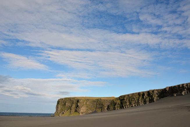
Dyrhólaey - Headland
Sheer headland rising 120 metres out of the sea with a huge natural arch near Vík Mýrdal. Reynisdrangar sea stacks and Mýrdalssandur sands are also magnificent sights. An amazing area of strength and beauty.
GPS N63° 24.229‘, W19° 6.244‘
Reynisdrangar and Reynisfjara - Black Beach

The famous “black beach” with basalt columns and magnifi cent sea stacks. The waves here are deceiving so please take great care and keep a good distance from the sea. The car park is equipped with good facilities, a restaurant and WC.
GPS N63° 24.254‘, W19° 2.671‘
Hjörleifshöfði - Headland
Hjörleifshöfði is a 221 metre high headland made of tuff. For a long time after the last ice age it was an island but now it lies more than two kilometers from the sea.
GPS N63° 25.475‘, W18° 46.076‘
Eldgjá - Eruptive fissure
In the Highland by road F208 the eruptive fissure Eldgjá is to be found. Eldgjá is an approximately 40 km long eruptive fissure, 600 metres wide in many places and up to 200 metres deep. From 934 to 940 AD an eruption occurred along the whole fissure and poured magma estimated 18 km out of the earth. Today Eldgjá is a peaceful place with the magnificent waterfall Ófærufoss located in the middle of the fissure. The area is a part of Vatnajökull National Park. GPS N63° 57.120‘, W18° 38.198‘
The Vatnajökull region
Skaftafell and Svartifosswaterfall

Öræfi was Iceland’s most isolated district before the bridges to the west of it were completed in the early seventies. The natural contrasts are breathtaking: black sands below white glaciers, desolate wastes and green vegetation. Such a green oasis welcomes you at Skaftafell, just beside the broad desert of the Skeiðarársandur sands and the raging Skeiðará river. GPS N64° 00.994‘, W16° 27.964‘
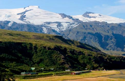
Öræfajökull - Glacier

Katla Geopark includes geological features of global significance. Over 150 volcanic eruptions have been recorded in the area since the 9th century. The eruptions created the landscape and influenced where people settled. Through the centuries, man and nature have affected the region‘s history. The area is constantly changing due to volcanic activity.
A Geopark is defined as territory that includes a particular geological heritage and a sustainable territorial development strategy to promote development. The Geopark covers about 9% of Iceland, 9542 km and follows the borders of three municipalities, Skaftárhreppur, Mýrdalshreppur, and Rangárþing eystra. About 2700 people live within the Geopark.


GPS N63° 26.347‘, W20° 16.140‘
Merkjárfoss/Gluggafoss – Waterfall

The Merkjá River has several beautiful waterfalls, but the most outstanding is Gluggafoss or Window Falls. The upper half of the cliff is palagonite or tuff rock and the lower ledge is basalt. The river has formed tunnels and grooves through the soft rock and a series of ‘windows’ in the tunnels, thereby earning the name ‘Gluggafoss’.
GPS N63° 43.050‘, W19° 53.674‘
Seljalandsfoss - Waterfall
Seljalandsfoss is just over 60 metres high in a lovely location, surrounded by cliffs and green slopes. A footpath leads behind the waterfall.


GPS N63° 36.963‘, W19° 59.614‘
Þórsmörk - Valley
Þórsmörk is a beautiful woodland nature reserve surrounded by rugged and majestic mountains, glaciers and glacial rivers. Þórsmörk can be reached all year round on 4x4 vehicles and by scheduled busses during the summer. Two unique hiking paths lead to Þórsmörk; Laugavegur, which starts from Landmannalaugar and Fimmvörðuháls from Skógar.
GPS N63° 40.789‘, W19° 35.564‘
Skógafoss - Waterfall
One of Iceland’s most splendid waterfalls, Skógafoss tumbles 60 metres from the cliffs by Skógar. Before cascading off the cliffs as Skógafoss, the river flows through the Skógárgil gorge, which boasts more than twenty more waterfalls, each with its own charm.


GPS N63° 31.762‘, W19° 30.782‘
Fjaðrárgljúfur - Canyon
Fjaðrárgljúfur is magnificent and massive canyon, about 100 metres deep and about two kilometres long. The canyon has sheer walls, and is somewhat serpentine and narrow. The river Fjaðrá has its source in the mountain Geirlandshraun and falls off the heath edge in this stunning canyon until it makes it down into Skaftá river. GPS N63° 46.272‘, W18° 10.298‘
Eldhraun - Moss covered lava field
In 1783 a huge lava flow streamed from Lakagígar in what became known as the Laki eruption. This is believed to have been one of the biggest lava flows in single eruption in the history of the world. It‘s cubic measure is approximately 16 km and the square measure around 580 km All around thick woolly fringemoss forms a continuous layer. The moss is very sensitive for tramping so please stay on trails. It has taken the moss 200 years to grow and one step will make a scar into the layer which can take a decade to grow back.
GPS N63° 44.807‘, W18° 9.623‘
Vatnajökull National Park


The national park includes the ice cap and its surroundings, with a total area of 14.967 km or 15% of Iceland. Few places in the world exhibit such a wide range of natural phenomena. The battle between ice and fire still rages within the park boundaries. Vatnajökull is the world‘s most voluminous glacier outside of the arctic regions. The glacier seems so close to the people of Southeast Iceland that they sometimes refer to the ice as if it were part of their backyard. Each of the icefalls and glacier tongues flowing towards the lowlands possesses an individual character and offers a variety of scenes.
Lakagígar - Craters
Lakagígar (Laki Craters) lie in a row, 25 km in length, in the Highlands above Kirkjubæjarklaustur. Mt. Laki commands splendid views of the craters and the surrounding landscape. The area is only accessible by 4x4 vehicles and by bus as there are unbridged rivers to cross. The Lakagígar and its surroundings is a part of Vatnajökull National Park and are extremely sensitive to intrusion and are travellers therefore encouraged to seek information before entering the area.
GPS N64° 3.876‘, W18° 14.688‘
Extending south from the Vatnajökull ice cap and towering to 2110 m, Öræfajökull is Iceland’s highest mountain. Its height actually depends on the season and the depth of snow, since the peak itself, Hvannadalshnjúkur, is topped with ice which is thickest in spring and thinnest in autumn. Skaftafell and Öræfajökull are a part of Vatnajökull National Park. GPS N64° 00.850‘, W16° 40.622‘
Ingólfshöfði - Headland
At the edge of the Atlantic Ocean, Ingólfshöfði is a headland which is isolated by black sands and perilous rivers from the rest of the mainland. However, it is home to thousands of nesting seabirds and gulls, especially puffins and the great skua. This historical cape is named after the first settler of Iceland, Ingólfur Arnarson, who spent his first winter there with his family after moving to Iceland, 874-875 A.D. The road is under deep water in some areas and only passable for 4x4 vehicles and drivers who know the road. Do not drive there on your own. GPS N63° 48.101‘, W16° 38.207‘
Jökulsárlón - Glacial lagoon

The size of the main lagoon, called Jökulsárlón, is about 20 km In 1932 the same area was still covered by ice. Many species of fish are found there, as well as seals, which can number into the hundreds during winter. Jökulsárlón is a part of Vatnajökull National Park. GPS N64° 02.899‘, W16° 10.795‘
Haukafell - Recreation area
In 1985 the local Forestry Society started planting saplings at Haukafell. Not only are the trees now becoming established, but there are bountiful berries to be picked every August. This pleasant outdoor spot also has a good campsite and washing facilities. GPS N64° 20.781‘, W15° 29.882‘
Heinaberg - Mountain
The Heinaberg area is part of the national park, and offers interesting sets of basalt columns in addition to the glacier tongue Heinabergsjökull and the lagoon. The valley Heinabergsdalur, 7 km long, reaches to Vatnsdalur valley, which ice used to dam off and keep full of water. Nowadays, the view down into the valley is magnificent, since massive icebergs are often left stranded along its floor. GPS N64° 17.878‘, W15° 39.048‘
Lónsöræfi/Stafafellsfjöll - Wilderness
The Stafafellsfjöll mountains, called Lónsöræfi, dominate the skyline east of Vatnajökull glacier and have long included one of Iceland’s most extensive protected areas. Besides the deep, rugged canyons, the landscape displays a wide range of colours due to rhyolite and other attractive rocks. In contrast, there are lushly vegetated, sheltered valleys, and a good chance of spotting reindeer. The area has many hiking trails but it is very difficult to access by car. Do not drive there on your own without consulting a trusted local. GPS N64° 33.194‘, W15° 09.078‘
Katla UNESCO Global Geopark