
Architecture and Urban Design Portfolio 2024
ABOUT ME

My name is Mariana Jasso Ahumada. I'm 23 years old and I was born and raised in Monterrey, an industrial city located in North-eastern Mexico. I completed my architecture bachelor's degree this summer 2024 at Universidad de Monterrey. I have also had the opportunity to go abroad, to France, Japan and Switzerland during my years at the university where I have developed in different areas. My main interests as a architect consist in urban planning, public space design, construction project management, interior and residential design.
As an architect, I truly believe that we are responsible for the growth of cities and how people develop in them, as well as the experiences that people can have inside and outside the spaces we design and how we can improve their quality of life one design at a time.
Jane
Cities have the capacity to provide something for everyone, only because and only when they are created for everyone.

Jane Jacobs
Urban García District
Strengthening Garcia's Identity through a Public Spaces and Mobility strategy.
MOCA: Regeneration of Melchor Ocampo Street
End-of-degree dissertation. This project aims to enhance public spaces and mobility based on a perception of te urban imagen. Focusing on accessibility, integration, and heritage.
An urban regeneration project for Downtown that plans to have a linear park of 2,337 m.
CIENTE: Wellness Center

Space for personal growth on a physical level as well as on a mental level to an entire community within the same space.

Regeneration of the Urban Center of Monterrey
An initiative that was thought to bring life to the city and reactivate several forgotten spaces within the center.


Jacobs
1
3
Strengthening Garcia's Identity through a Public Spaces and Mobility strategy.
URBAN GARCIA DISTRICT
The urban improvement project in Garcia, Nuevo Leon, is based on a perception study that reveals a positive vision of the municipality, although with areas of opportunity in security, transportation and tourism. The transformation will focus on a network of public spaces and mobility improvements. Design criteria include accessibility, integration, social interaction, functionality, safety and heritage appreciation. Mobility and service issues will be addressed, taking advantage of architectural and cultural assets. It is proposed to improve the urban image, public spaces and transportation routes, integrating natural and cultural elements to enhance tourism and quality of life in Garcia.

García, Nuevo León, México
The urban center of Garcia is part of the Monterrey metropolitan area and is located 58 km from downtown Monterrey, the largest city in Nuevo Leon. The municipal seat is divided into two zones: the central zone, which is the oldest and most preserved, and the peripheral zone, which is more recent and has a mixed and densified development.
Saltillo, Coah.
The city is home to several museums, including the Desert Museum, which exhibits the natural and cultural history of the region.
The total population of Garcia in 2020 was 397,205 inhabitants, 49.5% female and 50.5% male. The age ranges that concentrated the largest population were 5 to 9 years old (43,316 inhabitants) and 30 to 34 years old (39,649 inhabitants). Between them, they accounted for 31.5% of the total population.
Commerce, services and tourism is the second most important economic sector in Garcia, Nuevo Leon, accounting for 26.9% of the employed labor force. This sector is led by retail trade, which employs more than 40,000 people in the city. Construction is the third most important economic sector in Garcia, Nuevo Leon, and represents 18.2% of the employed labor force. This sector is led by housing construction, which employs more than 30,000 people in the city.
Monterrey, NL. Santa Catarina, NL.
Constantly growing and developing, with a mix of industrial, commercial, residential and recreational aspects. Its strategic location in the Monterrey metropolitan area makes it an important urban center in the region.
Garcia's historic center is home to buildings and structures with colonial architecture that reflect the region's historical heritage, dating back to the 19th century.
It is the second most populated city in the country, with a population of more than 4 million inhabitants. Monterrey is an important industrial, commercial and cultural center.


Natural landmarks in the municipality
 Mina Icamole
State boundaries
Neighboring municipalities
Interventions

Urban identity
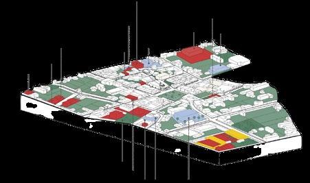

Public space and land use Mobility
circuit
Contrast Analysis
Before Garcia District

Public Space

Ebano


Architectural interventions

Public Space interventions


Urban identity interaction
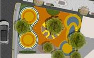
 park Huizache park Palo Verde park
Duraznillo park
park Huizache park Palo Verde park
Duraznillo park
Planta
Isometría
Esc. 1:100 Esc. 1:100 Esc. 1:100 Esc. 1:100 Esc. 1:75 Esc. 1:75 Esc. 1:75 Esc. 1:75 Esc. 1:100 Esc. 1:100 Esc. 1:100 Esc. 1:100
Corte


 Virtual Tour AR Tour
Counterproposal
MOCA: MOVIMIENTO OCAMPO
Movimiento Ocampo is an initiative in which the creation of a linear park is planned. MOCA is an urban regeneration project for Downtown that plans to have a linear park of 2,337 m starting at Venustiano Carranza Ave. to the Macroplaza and connecting to Fundidora Park. It is intended to create a zoned community, in which a few meters away you have the essentials to develop your daily life, thus generating a better quality of life.

The objective of this counterproposal is to revitalize one of the most relevant avenues of the last decade, Melchor Ocampo Avenue, and to contribute to the regeneration of Monterrey's urban center. It is also intended that through the creation and implementation of new sidewalk designs, accessible connectivity between spaces, street furniture and provide maintenance to existing public spaces, better urban spaces with higher quality and better guidelines that allow a higher density in the area to attract more people to the area and the space becomes safer and more used.
Project done in collaboration with Andres García, Pamela Herrera and Alejandra Gomez.

 Rendering of the MOCA Master Plan by Duda Paine Architects in conjunction with Proyecctos 9, illustrating the development of Movimiento Ocampo.
1
Santa Catarina River

Site Analysis
The study area runs from Venustiano Carranza Sur Street to Juan Zua Zua Avenue. It covers the secondary streets Alejandro de Humbolt and Melchor Ocampo.
1 1 1 1 1 1 1 1 1 1 1 1 1 1 1 1 1 1 1 1 1 1 1 1 1 1 1 1 1 1 1 1 1 1 1 1 1 1 1 1 1 1 1 1 1 1 1 1 1 1 1 1 1 1 1 1 1 1 1 1 1 1 1 1 1 1 1 1 1 1 1 1 1 1 1 1 1 1 1 1 1 1 1 1 1 1 1 1 1 1 1 1 1 1 1 1 1 1 1 1 1 1 1 1 1 1 1 1 1 1 1 1 1 1 1 1 1 1 1 1 1 1 1 1 1 1 1 1
Location
 Alejandro Humbolt Street
Melchor Ocampo Street
SOHL Tower
411 tower
Pabellon M
Alejandro Humbolt Street
Melchor Ocampo Street
SOHL Tower
411 tower
Pabellon M
1
Cuahutemoc Center Ocampo Center
Mobility and Transportation Zoning and Activities Security and

Vegetation


Accesibility Facades


Urban Furniture
Sections Primary Rode Tertiary Rode Vehicle Node Metro Station Bus Stop Services and Commerce Equipment Multifamily Housing Medium Mixed Housing Intense Mixed Housing Green Areas Santa Catarina River Public Telephones Vegetation on Sidewalks Inexisting Public Lighting Existing Public Lighting Pedestrian Traffic Lights Fresno Encino Ebany Mesquite Boxwood Bougainvillea Duranta Ruellias Wasteland Public Private Zoning of green spaces Types of vegetation Wheelchair Ramp Pedestrian Crossings No existing sidewalks 1 2 3 4 5


8.60 m 5.30 m 0.0 m
Elevation
Blvd. Constitución
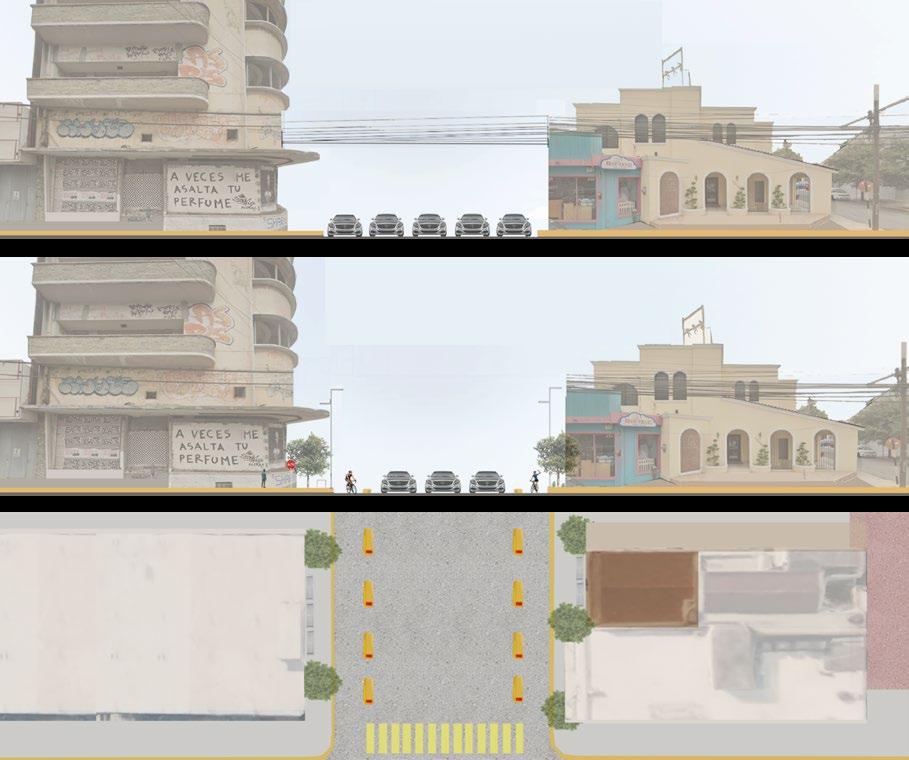
Street cut
Color Palette Materials and Texture
Melchor Ocampo Street

5.20 m 3.30 m 0.0 m
Elevation
1
Color Palette Materials and Texture
Counterproposal
This counterproposal also seeks social and spatial inclusion of the different projects planned for the area, in order to create an accessible mobility with recreational and dignified public space.
1 1 1 1 1 1 1 1 1 1 1 1 1 1 1 1 1 1 1 1 1 1 1 1 1 1 1 1 1 1 1 1 1 1 1 1 1 1 1 1 1 1 1 1 1 1 1 1 1 1 1 1 1 1 1 1 1 1 1 1 1 1 1 1 1 1 1 1 1 1 1 1 1 1 1 1 1 1 1 1 1 1 1 1 1 1 1 1 1 1 1 1 1 1 1 1 1 1 1 1 1 1 1 1 1 1 1 1 1 1 1 1 1 1 1 1 1 1 1 1 1 1 1 1 1 1 1 1

With this intervention it was mainly thought of creating a new landscaping design, widening streets, improving street lighting and implementing crosswalks which did not exist in the area.
The initial purpose of this pavilion is to create a flagship landmark for the area, a logo of gender diversity and respect for others. The morphology of the shape, of intertwined triangles, represents the union that is intended to be present in the area.


This intervention was mainly intended to create better mobility within the area, widen the streets, improve street lighting and implement crosswalks that did not exist in the
The initial purpose of the restructuring of Cuauhtemoc Street was to improve mobility and pedestrian access to the area's commerce, as well as to reduce the speed of traffic coming from one of the main metropolitan streets of the city.

CIENTE: WELLNESS CENTER
This center is born from the problem of wanting to provide a space for personal growth on a physical level as well as on a mental level to an entire community within the same space. Creating new habits, and relationships between people who seek to increase their quality of life in a healthy way and that as a consequence these actions and good way of living have positive repercussions in the neighborhood.

The positive impacts of the center extend into the broader community. As individuals improve their physical and mental health, they are better equipped to contribute positively to their surroundings. Increased well-being can lead to greater community involvement, reduced healthcare costs, and a generally more vibrant and cohesive neighborhood.
A Path to Well-Being.

The center serves as a hub for building meaningful relationships. People from diverse backgrounds come together with a common purpose, forming connections that might not have been possible otherwise. These relationships are crucial for creating a supportive network that extends beyond the center’s walls, enhancing the social fabric of the entire neighborhood.
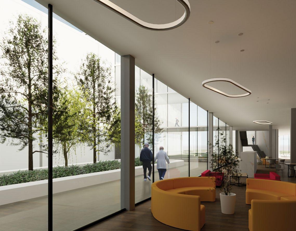

Materiality and spaces designed for the emotional comfort that these provide to the user, in order to generate a harmonious environment in which people feel invited and welcomed so that they can fully develop their emotions, thoughts and physical activities.


Within the center, a series of different activities will be developed that contribute to the well-being of the user, which are divided into four different levels: The commercial area, physical health, mental health and the area of stay for emotional recovery.


 South Elevation
North Elevation
South Elevation
North Elevation

REGENERATION OF THE URBAN CENTER OF MONTERREY
As the city continues to evolve and transform, dead edges begin to appear in the urban landscape, subsequently reducing the level of activity in our built environment. With these dead edges, an initiative was thought to bring life to the city and reactivate several forgotten spaces within the center, as well as the redesign of several blocks that lacked identity.
Solid/Void Analysis Urban Morphology

Pedestrian Analysis


Analysis

Vehicle Access
Sections
Primary
Secondary
Tertiary
Vehicular


Path
Vegetation Solid Void Reticle Broken plate reticle Open Dispersed Compact Site Noises Winds Cerro de la silla Sierra Madre
Path
Path
Path
Node Wasteland Public Private Bus stops Pedestrian Concentration
CONCEPT PLAN

Noises Bus Stops Wide sidewalks Esc 1:800
Interventions
Actual View

Intervention A Porfirio Diaz
For this intervention, the focus was revitalizing public space and restructuring Profirio Diaz Avenue in central Monterrey. The project aimed to improve pedestrian accessibility, integrate green spaces, and enhance social interaction, creating a vibrant, inclusive urban environment that promotes community engagement and elevates the quality of life.


Intervention
Elevation
Top view
Elevation
Intervention B Av. Hidalgo
A comprehensive intervention radius was considered to enhance pedestrian mobility, involving multiple nodes. The design included wide sidewalks, an optimized roadway, and signage that adheres to accessibility guidelines.


Intervention Elevation Elevation Top view Actual View

Intervention C Pedestrian urban corridor
The design featured wide sidewalks, an optimized roadway, and accessible signage. Additionally, a pedestrian corridor and green medians were implemented to create urban lungs, improving the environment and quality of life in the area.


Intervention Elevation Elevation Top view Actual View
