acknowledge the Wonnarua People as the Traditional Owners and Custodians of the land within the Maitland Local Government Area. Maitland City Council pays respect to all Aboriginal Elders, past, present and future with a spiritual connection to these lands.
1. Introduction
Residential density has been successfully used as an urban planning tool to create vibrant and liveable cities and neighbourhoods across the world. Density can significantly influence the functionality, sustainability and overall quality of city life. To ensure density does not result in congestion or unsympathetic outcomes, it needs to be planned and guided in the right location and supported by appropriate infrastructure.
Planned density helps us to ensure that housing is available for our growing and changing population. It also means households have access to a greater choice of more affordable housing both in existing
and new communities located near jobs, schools, parks, shops and other services. These communities are supported by walking, cycling, public and private transport options and the existing infrastructure and services are efficiently used to achieve both economic growth and environmentally sustainable outcomes.
Achieving appropriate residential densities requires a significant level of collaboration between all levels of government, communities, development industry, community housing providers, and utility suppliers.
This Residential Density Guide is the first step in this journey and provides a road map for Maitland to transform its approach to delivering neighbourhoods and homes that better meet the needs of our communities.
1.1 Purpose of this guide
The Maitland Local Housing Strategy 2041 is a forward-thinking plan aimed at transforming the city’s housing landscape. This Strategy builds on the long-term vision established in the Maitland Local Strategic Planning Statement and Community Strategic Plan, and is informed by a number of NSW Government plans and strategies including Hunter Regional Plan 2041. All these plans and strategies highlight the need for increasing densities in our neighbourhoods.
Increasing densities in our greenfield release areas and existing urban areas can meet the changing needs of our existing and future communities, providing for greater housing choice, making housing more affordable, situated in the right location and supported by appropriate infrastructure.
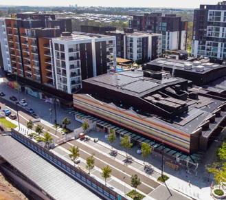
There are significant opportunities for increased densities within our established urban areas through urban renewal (commonly known as urban infill housing), particularly around town centres and railway stations. Increased densities can align with, or even strengthen, the character of an area and community ambitions to locate housing within walking distance of shops, services and open spaces.
Planned densities in our greenfield release areas also present an opportunity to maximise development yield while achieving higher standard of amenity. The location of planned densities in greenfield areas should be identified at the early stage of planning and be supported with appropriate infrastructure and land use zoning. This ensures that increased residential densities are supported by walkable neighbourhoods within close proximity to neighbourhood centres, schools, community and recreation facilities and transport nodes.
The purpose of this Density Guide is to:
• Start the discussion between Council, residents, the development industry and other stakeholders about appropriate densities for Maitland.
• Provide a clear framework in defining, determining, and applying densities for the Maitland context.
• Provide guidance and inspiration on suitable forms of density and housing typologies for future urban renewal areas and greenfield release areas in Maitland.
• Inform planning proposals, development applications and future changes to planning controls.
This Guide has five main chapters:
Chapter 1 explains the purpose of the document and offers an overview of Maitland.
Chapter 2 defines what density is and how it is measured.
Chapter 3 offers a dwelling density matrix and a set of criteria to identify appropriate density.
Chapter 4 combines the key learnings and establishes key principles to guide infill and greenfield development.
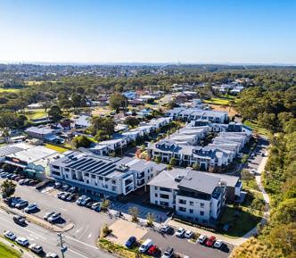
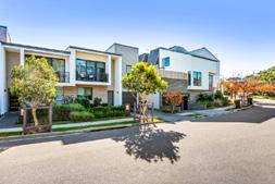
Appendix A outlines a selection of recently completed residential developments, showing density done well.
1.2 How to use this guide
This Guide has been prepared for both Maitland City Council and applicants planning residential development within the Maitland Local Government Area.
The Guide describes:
• The definitions of different residential density measures and the purpose of each.
• How the different residential measures can be used in the planning for the future growth of Maitland.
• The different housing typologies suitable for the Maitland context.
• Guidance on how to select the appropriate density for selected locations.
• The need for infrastructure and services provisions in support of residential densities.
• Built form controls that enable various densities.
The Guide serves as a practical tool throughout various stages of the planning and development process. It translates strategic concepts of residential density into guidance on appropriate housing forms and provides criteria for assessing proposals.
The Guide supports the preparation of:
Local Area Planning
This guide can be used to inform the preparation of local area plans including precinct plans, master plans, structure plans or any other local area plans on greenfield or infill sites to ensure that appropriate densities, housing typologies and supporting infrastructure are delivered.
Amendments to Planning Controls
This guide can be used to refine the planning controls in the Local Environmental Plan and the Development Control Plan to ensure they deliver the overarching strategies in the Local Housing Strategy.
Development Applications
This guide can be used to ensure that housing typologies, including form and scale, are appropriate for a particular location.
Figure: Policy and strategic context
Regional and Metropolitan Planning
Maitland Residential Density Guide
targets provides guidance
Maitland Local Housing Strategy
1.3 Maitland’s story
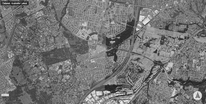
For much of Maitland’s history, housing has been provided in a low-density form, often as a house in the middle of a block of land. As a result, our urban footprint is growing, being 3 times that compared to 40 years ago. If we don’t adjust our planning approach, it will continue to grow in the coming decades.
Maitland’s community is not only growing but is also witnessing a trend of shrinking households and an aging population. It has become evident that the more traditional housing stock, characterised by large single detached houses on the urban fringe, is no longer suitable. In addition, housing affordability concerns, propelled by rising construction material costs and the impact of climate change, further emphasize the need for a diverse and more sustainable approach to housing.
Today, higher density is only a small portion of the overall housing supply. The result is that our residents need to travel longer distances from their home to work - to school- to shop, at greater personal expense. This has various social, economic and environmental implications, from lower productivity to rising greenhouse gas emissions and urban encroachment on valuable agricultural land.
These low density outcomes are facilitated by the current planning and development controls in Maitland (LEP permissibility, DCP controls, and engineering standards) and need refinement to create different outcomes. Maitland can meet the evolving needs of its population and improve liveability to ensure a sustainable and vibrant future for generations to come. For this our planning controls need to support denser, connected, and resilient development in both greenfield and infill areas.
As Maitland’s population grows and changes, there is a clear need to rethink housing delivery, in particular what appropriate densities can achieve. The focus should be on:
• Ensuring future homes meet the needs of Maitland’s growing and changing population,
• Ensuring that new housing is located in areas that enhance access to essential services, employment and open spaces.
• Offering a variety of housing types and sizes to accommodate different household needs,
• Improving housing affordability and sustainability outcomes
• Minimising environmental impacts and
• Enhancing community well-being.
As the Maitland population grows the infrastructure to support the population also needs to be provided. The best value can be obtained when existing infrastructure is used or upgraded - providing benefit to both existing and future residents. Development in greenfield areas typically has a much higher cost per future resident than embellishment of existing infrastructure.
The planned growth can deliver benefits including diverse housing and jobs, public spaces and public transport, entertainment, health and education services. We need to consider the needs of those who live here now as well as our future residents. Thoughtful planning will help us shape our growth in a positive way, that enhances Maitland’s unique natural environment, its scenic beauty, local heritage, and rural outlook.
In the early 1900s, neighbourhoods were typically planned around mixed land uses, with easy pedestrian access to goods and services (walkable neighbourhoods). This approach is visible in more traditional neighbourhoods and towns developed before 1960s around the world and in Maitland.
The invention of automobiles led to a paradigm shift in urban planning, transforming the way cities were planned and developed. The affordability of automobiles and the availability of government-funded infrastructure, such as highways, freeways and carparking, encouraged people to move to suburban areas. These often featured low-density housing, dominated by larger lots and single-family homes, catering for, and at the same time creating car dependent communities.
The combination of low density, separated land uses and carprioritising infrastructure decisions has consequences in terms of household costs, equity, and choice, as well as public health and infrastructure costs and greenhouse gas emissions and air pollutants etc.
2. What is density?
2.1 What is density?
Density measures are useful tools for planning and development practitioners, helping to ensure a shared understanding of what density is and how it should be measured. This assists all parties in setting and achieving suitable density targets for well-designed places.
The two distinct types of densities are population density and residential (dwelling) density which are outlined below. The focus of this Guide will be on residential density.
Population Density
Population density measures the concentration of people over a specified land area. This is different from residential density - as dwellings can contain any number of people.
Residential Density
The most common form of density is known as residential density. Residential density is the concentration of dwellings in a given land area.
Residential vs Population Density
Both these areas have the same number of dwellings - but the number of people in each dwelling varies. The area on the right has a higher population density. It also has larger dwellings and will have a different built form character.
An example: a site with 15 dwelling units per hectare can have a density of 20 people per hectare if the area is full of empty nesters and elderly people, or a density of 40 people per hectare if families with children or extended families live there. Similarly, a tower targeted at couples with no kids can have a lower number of people per hectare than a mid-rise development targeted at families with children. The devil is in the details. This difference can have a huge impact in terms of how many people are available to support community services, transit, and infrastructure. Given that regulating household size is a challenge for governments, policies tend to focus on dwelling unit densities as a surrogate.
Residential density is the concentration of dwellings within a given land area. Increasing density means accommodating more people on less land while locating them closer to shops, schools, jobs and services. This is often achieved by providing a greater diversity of housing choices within neighbourhoods, benefiting communities socially, economically, and environmentally.
2.2 How is density measured?
Density can be expressed in various ways, as it largely depends on the scale at which you are working. The scale could range from a site to a street block or a neighbourhood or an entire city, and the chosen scale will influence the method and approach used to measure residential density. An important factor to consider when measuring residential density is what is included and excluded in terms of land area.
The most common measures include:
Urban Density is used at the regional/ metropolitan scale to estimate population density for utilities or regional services such as employment, transport and regional open space.
Gross Density is used at the neighbourhood scale - it best reflects the actual human experience of a place. The defined area includes roads, neighbourhood parks and services and infrastructure within a walkable distance from the home.
Net Density is used at the street or precinct scale. It includes roads that service the residential uses. It can be used as an averaging statistic over a larger area when comparing a mix of building types and can assist in ensuring the development of individual precincts meet targets at a neighbourhood or urban level.
Site Density is used at the lot scale. It includes only the residential component of the land area. It is the most concentrated measure of density.
Diagram 2: Four areas all with 75 dwellings per hectare. The form, scale and open space of each area varies considerably however the density measure remains the same.
Residential Density = Number of Dwellings
Land Area (ha)
(Which land uses are counted in the land area determines the type of residential density being measured)
URBAN
PURPOSE
• Understand density of existing places
• Evaluate proposed densities
• Estimate population densities
• Calculate needs for utilities and services (like education, health)
HOW IS IT CALCULATED
APPLICATION SCALE
URBAN DENSITY
When measuring Urban Density, the land area includes all land included in the Gross Density plus regional uses such as:
• Education (University & TAFE)
• Open Space (regional parks, environmental protection reserves)
When measuring Gross Density, the land area includes the lots occupied by the dwellings, plus:
• Internal public streets
• Local open space (like parks, sports fields, drainage reserves landscape buffers)
• Local and neighbourhood shops
• Primary and secondary schools
• Local community services
• Local employment areas
• Half the width of adjoining roads
• Large scale redevelopment/infill sites
• Neighbourhood Subsivisions
• Structure Plans
• Planning Proposals
• Development Control Plans
PRECINCT OR STREET
• Evaluate street design and built form
• Investigate the impacts of development standards
NET DENSITY
When measuring Net Density, the land area includes the lots the dwellings occupy, plus:
• Internal public streets
• Half the width of adjoining roads that provide vehicular access to the dwellings.
• Masterplans
• Precinct Plans
• Planning Proposals
• Development Controls Plans
• Subdivision Plans
• Development Applications
DEVELOPMENT SITE / LOT
• Comparative tool (e.g for detached housing it correlates strongly with lot size and for apartments it correlates strongly with height)
• Estimate lot yield
• Typically used to express Floor Space Ratio (FSR)
SITE DENSITY
When measuring Site Density, the land area includes the lots occupied by the dwellings.
Can be expressed as dwellings / ha but typically expressed as floor space ratio - as defined in the Local Environmental Plan.
• Development Applications
2.3 Density, intensity and amenity
Density does not necessarily capture the intensity or ‘feel’ of a place. While density depends on factors like lot size, floor space ratio, building height, street width and parking requirements, the intensity of a place is influenced by the width of lot frontage, topography, the maturity of trees and landscaping, front setbacks and gardens, street design and traffic. Although density measurements can serve as indicators of intensity, they are never complete descriptors.
Amenity generally means proximity to shops and other services required for daily living, including access to jobs, transport, health, education, leisure services and green spaces. Areas with high levels of amenity are more pleasant and attractive places to live, work or visit.
A higher residential density does not always mean taller buildings. The same type of housing can result in varying net residential densities based on site coverage, dwelling size, and street layout. Residential density does not measure the qualitative factors that affect the feel of a place such as mature trees, landscaping, traffic, or architectural quality.
The density target for an area should serve as longterm goals, not generic “one size fits all” planning controls. A mix of housing types is generally best achieved when density targets are varied within a locality.
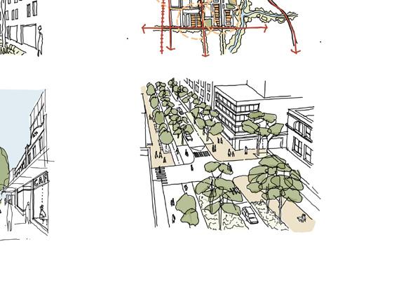
Creating intensity is often desired in and around the local centres - this creates the ‘buzz’ of activities desired to active neighbourhoods and supports the economic development of the area. Intensity brings certain development closer together - it is the combination of the building design, but also the width of streets and the use of the public spaces.
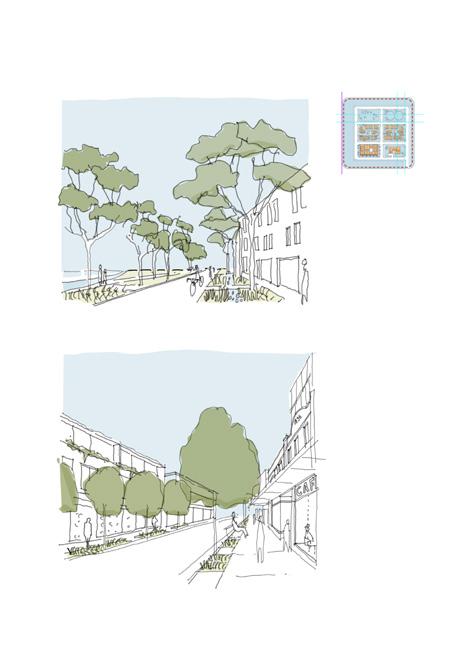
As you get closer to a centre, the balance of private and public domain changes. Streets and lanes take on different uses and need to be designed differently to improve walkability and connectivity.
Increasing density means that we accommodate more people and homes in the space that we have, while at the same time improving liveability. Higher densities offer several advantages. They allow us to create communities where specialised amenities are close to our homes. They also sustain better transport connectivity and creation of high-quality public spaces.
Intensity changing - outer vs inner areas
How does density relate to land use planning
The planning system in NSW regulates land uses by designating different land use zones across the LGA. While the permitted uses in a zone contribute to the overall character and density, there can be considerable variation in density within a single zone.
This guide is not based on the current planning or development controls outlined in the Maitland Local Environmental Plans (LEP) and Development Control Plan (DCP) 2011. It indicates that what is preferred and how it can be achieved through development proposals which may require changes to Maitland LEP and DCP to realise the proposed density outcomes. Furthermore, this guide highlights the built form, land use intensity, amenity and character outcomes rather than the use. For example, a senior living development could be located in a mid-rise apartment or low-density villa development. The guide indicates the typical land use zones utilized to achieve the desired density, character and intensity of use.
The NSW Department of Planning, Housing and Infrastructure’s Standard Instrument LEP sets standard zones that councils may use within their LEPs that include residential uses.
Residential
• R1 General Residential
• R2 Low Density Residential
• R3 Medium Density Residential
• R4 High Density Residential
• R5 Large Lot Residential
Rural
• RU1 Primary Production
• RU2 Rural Landscape
• RU5 Rural Village
Other
• MU1 Mixed Use
• E1 Local Centre
• C4 Environmental Living
Way of life
Way of life is about how people live, commute, work, play and interact each day. It directly influences the liveability of our cities (often referred to as quality of life) and determines how well they function. Most people travel from home for work, shopping, or services, often without much choice about the distance, mode of transport, or the necessity of travel. A denser urban environment should facilitate easy commuting by providing accessible public transport and well-planned walking and cycling routes. This reduces traffic congestion, enhances productivity, and contributes to the city’s economic growth.
A person’s quality of life is affected by their ability to easily fulfil daily needs, such as grocery shopping, school trips, work, and social interactions. A wellplanned urban area ensures the proximity of essential amenities, reducing the need for long commutes. Integrating grocery stores, cafes, fuel stations, and other daily necessities into neighbourhoods creates a more sustainable and convenient lifestyle for residents. It also provides opportunities and access to amenities like sports facilities, playgrounds, and art galleries, which are crucial for personal development and cultural experiences.
As Maitland grows it should retain its connection to heritage, rural outlook, and enhance what makes it unique - providing an attractive vibrant river city. Welldesigned public spaces, parks, waterways, and green areas within walking and cycling catchments offer opportunities for relaxation, connection with nature and social networks. These spaces play a vital role in fostering mental well-being, community cohesion, and a sense of balance in urban life.
2.4 What does density look like?
GROSS RESIDENTIAL DENSITY (Dwellings per hectare)
<1 1-7 6-12 8-20
Typical zoning RU1 - Primary Production RU2 - Rural Landscape
Character Agricultural and rural landscape character is dominant.
Houses are scattered throughout the landscape.
Public Transport
Cycling Paths
Shops
Community Facilities
Parks
Typical zoning R5 - Large Lot Residential C4 - Environmental Living
Character Housing in a rural or semirural setting, emphasizing scenic qualities of the landscape.
Often used a buffer zone between urban and rural land.
Typical zoning R2 - Low Density
Residential RU5 - Large Lot Residential
Character Traditional houses on a block with setbacks to side boundaries and large back gardens.
Established areas further away from the major centres.
Typical zoning R2 - Low Density
Residential
Character Single houses with setbacks to the street.
Occasional semidetached dwellings and secondary dwellings.
REGIONAL CYCLING
DRIVE TO LOCAL SHOPS
DRIVE TO COMMUNITY FACILITIES
DRIVE TO LOCAL PARKS
15-35 30-60 45-100 100+
Typical zoning R1- General Residential R3 - Medium Density Residential
Character Housing on smaller lots with reduced front setbacks.
Variety of different dwelling types.
Small shops, community and childcare centres.
Typical zoning R3 - Medium Density Residential
Character Increased residential densities in a midrise form.
Smaller front setbacks.
Combination of semi-detached, attached, terrace, town house, shoptop, walk up apartments.
Typical zoning R4 - High Density Residential MU1- Mixed Use
Character Dense urban residential forms. Buildings setback from street.
Small scale ground level retail to provide convenient amenities to residents.
Terrace, town house, apartments shoptop housing.
Typical zoning MU1 - Mixed Use E1 - Local Centre
Character Town centres and urban core. Urban streetscapes. Buildings define the street edges.
Setbacks at rear provide green space.
Apartments, shoptop apartments, mixed use
3. Appropriate density
When appropriate density is planned and managed effectively, it accommodates more people in an area while simultaneously enhancing liveability. Increased densities can offer a wide range of dwelling types and sizes, support better transportation options and provide quality public space closer to homes, contributing to more vibrant and connected communities. It responds positively to its site and context, integrates with various elements of the natural and built environment.
The Residential Density Matrix outlines the typical locations for various housing types within the urban structure and their expected densities. It also provides guidance on design parameters that can achieve good amenity outcomes. The appropriate density for an area evolves over time, and housing choices should consider context, including heritage, existing subdivision patterns and desired local character.
Our shared vision for Maitland is a connected city with thriving communities, supported by affordable and diverse housing options, ensuring that everyone has a place to call home at all stages of life.
3.1 How to choose the best dwelling type
Traditional neighbourhoods have always included a diverse range of housing types, enriching the community by supporting mixed populations and creating visually appealing streets. However, recent developments in Maitland have mostly featured single-family homes, lacking this diversity.
Housing diversity is a crucial factor - it enables neighbourhoods to provide for changing demographics, it helps address housing affordability issues and it provides for different lifestyle choices for different life stages including young families, single people and retirees. Having a wide range of dwellings makes it easier to meet the diverse housing needs of homeowners, renters, investors, families, one or two person households and first home buyers. Diverse housing in local neighbourhoods helps build diverse and socially interesting places and caters to households on a range of income levels.
Here are five key considerations for selecting appropriate housing types for different areas:
Choice
Ensure a variety of housing types and configurations are available at different price points including large lots, small lots, apartments of various sizes, courtyard housing, and homes with gardens to ensure there is a adequate choice for residents at varying stages of life.
Amenity
Amenities should be both internal and external. In areas with access to public amenities like parks, recreational facilities, and shops, private amenity spaces can be smaller. However, each dwelling should still have high-quality amenities, including access to sunlight and well-designed living areas both inside and outside.
Location
The location for each housing typology can vary depending on a number of factors: the width of the site; its location in relation to centres; its local character; the street type and function; and transport options.
Higher-density housing should be located near centres, with easy access to public transport and other services. In greenfield developments, creating new centres can enhance walkability and provide community anchors.
Lot size and character
Retrofitting existing subdivisions can be challenging. Consider the impact of lot orientation, street frontage, and shape. Different housing types suit different lot sizes: for example, dual occupancies are best on long, narrow lots, while apartments work better on wider lots or corner lots. Consideration should be given to retain existing vegetation to preserve the tree canopy and reinforce the area’s local character.
Housing mix
A mix of housing types should be distributed throughout an area to meet the different housing needs. It is important that diverse housing forms are not clustered in only one location in a neighbourhood, but that they are dispersed in a variety of locations.
The Residential Density Matrix demonstrates how these factors can be considered to determine the best location for each residential typology.
3.2 residential density matrix
TYPE
LOW - RISE HOUSING
DISTANCE FROM CENTRE OR TRAIN STATION
HOUSES SEMI-DETACHED HOUSES - DUAL OCCUPANCIES
> 800m from town centre
400-800m from neighbourhood centre 800-1500m from town centre
400m - 1200m from centre. Near openspaces, schools and other amenities 400 - 1200m from centre. TYPICAL LOT SIZE
(Parent lot - 450m2+)
CHARACTER Single dwelling on
CHARACTER
Two dwellings on
LANDSCAPED CHARACTER
• Front gardens presented to the street
• Rear garden
• Street tree planting
• Front gardens presented to the street
• Rear garden
• Street tree planting
(Parent lot - 500600m2+) > 20m width (area irrelevant)
1 with basements)
Multi-dwelling housing where all dwellings face and generally follow the alignment of the street
• Small front garden presented to street
• Rear garden or courtyard
Multi-dwelling housing with shared driveway and separate entrances.
• Dwellings in a landscape setting
• Ground floor private gardens with landscaped common areas.
STREET FRONTAGE Front street or battle axe for deep blocks House fronts street 15m min lot width
House fronts street and new lanes. 20m min lot width
Front: 5.5m Side : 0.9 - 3m Rear: 3m
PARKING Front Front Front or Rear Within the development
PUBLIC DOMAIN
Landscaped edge / garden style
Landscaped edge / garden style
Fences to street boundary
Landscape edge / gardens style
This matrix is not based on the current Maitland LEP and DCP. It suggests preferred development proposals that may require changes to achieve desired density outcomes.
MID - HIGH RISE HOUSING
CHARACTER Small low rise apartment buildingsset in a garden setting - setback on all sides. Looks like a big house.
TYPICAL
LANDSCAPED CHARACTER
LANDSCAPED AREA
STREET FRONTAGE
• Set in landscape setting to match the character of the area
CHARACTER
Low rise apartment buildings - define the street edge. Garden / courtyards at the rear and/or centre of block
• Landscape areas to rear for tree planting
Mid rise apartments with top floors above the tree canopy. Buildings define the street - courtyard communal gardens. Towers punctuate the landscape - create identity markers in centres between mid rise street aligned buildings.
• Landscape at rear
• Enhanced street tree planting.
• Landscape in common courtyards / podium / roof garden
• Street tree planting
Building fronts street. Allow space for tree planting
SETBACKS Front: 5.5m Side: 1.5m Rear: 6+m
Building fronts street with ground floor apartments address street
Front: 2.5 - 5.5m Side: 0-1.5m Rear: 9+m
PARKING Front or Rear Rear or basement
PUBLIC DOMAIN
Enhanced landscape to street
Tree planting in public domain
Building fronts street with ground floor apartments address street
Front: 2.5 - 5.5m Side: 0m Rear: 9+m
Building fronts street with ground floor apartments address street
Front: 2.5m Side: 0m Rear: 9+m
Rear or basement Rear or basement
Buildings align with street
Buildings align with street
DIVERSE HOUSING
LIFESTYLE VILLAGES / MANUFACTURED HOME ESTATES (MHE)
GROSS DENSITY Varies
TYPICAL NET DENSITY Varies
DISTANCE FROM CENTRE (TRAIN STATION)
• Located within the existing urban areas or greenfield release areas close to centers, public transport, community facilities and other amenities.
• Located close to existing public transport and institutions. Provides housing opportunities for students and workers in hospitals or educational establishment.
• Located and planned within existing urban areas or greenfield release areas to encourage more efficient use of land with greater accessibility to public transport, and other amenities.
TYPICAL LOT SIZE Greenfield 1ha/ Infill - Varies >600m2 Varies
FSR
Refer to Note 1 below
CHARACTER
CHARACTER
TYPICAL
Buildings in a landscape/resort setting
Similar to a small apartment building
Enhance vibrancy of the main street character
LANDSCAPED CHARACTER Dwellings and buildings located in a garden setting. Dependant on context. Landscape in public domain
LANDSCAPED AREA
Refer to Note 1 below
SETBACKS Internal streets
PARKING
PUBLIC DOMAIN
Dependant on context N/A
Front: 0m
Dependant on context
Side: 0m
Rear: Varies
Refer to Note 1 below Rear or Basement Rear or Basement
Extensive public domain
Dependent on context
Improvements to the public domain and footpaths
Note 1: MHEs require to meet the statutory requirements under the Local Government (Manufactured Home Estates, Caravan Parks, Camping Grounds and Moveable Dwellings) Regulation 2021 or update.
Note 2: The Maitland Local Housing Strategy 2041 (or its updates) provides a planning framework to guide housing development across Maitland, identifying potential areas for future growth.
Housing diversity
Housing diversity refers to a range of housing types, sizes and tenures available in an area to meet the needs of residents at different stages of their life. It will assist in achieving greater housing choice to meet the social and financial needs of our existing and future residents. In this context, increasing housing diversity will be a key element of addressing housing needs into the future and it needs to be encouraged in both established urban areas and greenfield release areas within the city.
Lifestyle Villages/ Manufactured Home Estates (MHEs)
A Lifestyle Villages/ MHEs often provides singular dwellings amongst a landscaped setting with internal shared pedestrianised roads. These villages provide a variety of shared outdoor and community spaces to facilitate a sense of community within the development.
Right location is a crucial factor for lifestyle villages/ MHEs, because it influences how easily residents can travel within and outside the area, it creates a balanced, functional and socially connected environment where residents have easy access to amenities and services strategically enhancing their quality of life.
• Permit lifestyle villages/manufactured home estates in appropriate zones (subject to NSW planning reforms) and introduce specific controls for site planning and design.
• Ensure adequate access to services and facilities and to enable freedom of movement for residents without the need for a private vehicle.
• Ensure that appropriate measures are implemented to mitigate land use conflict and social impacts.
• Ensure that traffic, stormwater and waste management solutions are an integral part of the design and operation.
Shop top housing
Shop top housing is an opportunity to provide housing in close proximity to services and transport routes whilst helping the economic activity of a centre with additional residents, and enlivening street life with a ground floor active frontage and passive surveillance above.
• Best suited to main streets and centres that require active retail or commercial frontage.
• Reduced car parking enables cost effective development.
• Provide mix of tenure - affordable, co-living and mid size apartments throughout the centre
• Support rear lane access.
• Encourage zero setbacks to side boundary walls to maintain a consistent street frontage.
4. Planning for density
Residential density outcomes are not solely a product of zoning and development controls - but are the result of many complex interactions between built form, natural environments, transport options and networks of roads, open spaces and other services. A holistic approach that balances these factors can lead to vibrant, liveable and sustainable urban environments that accommodate a growing and changing population while maintaining a high quality of life.
This Guide focuses on five key areas that collectively influence density outcomes in an area and establishes clear expectations for future infill and greenfield development:
• Urban Structure
• Movement and Connection
• Natural Systems
• Public Space
• Built Form
The Guide translates regional and local strategic directions relate to residential density into practical planning tool - offering developers, planners and designers a clear and transparent benchmark to inform future planning and development.
*Note: For more information on potential development opportunities, including infill areas near town centres and train stations, refer to the Maitland Local Housing Strategy 2041.
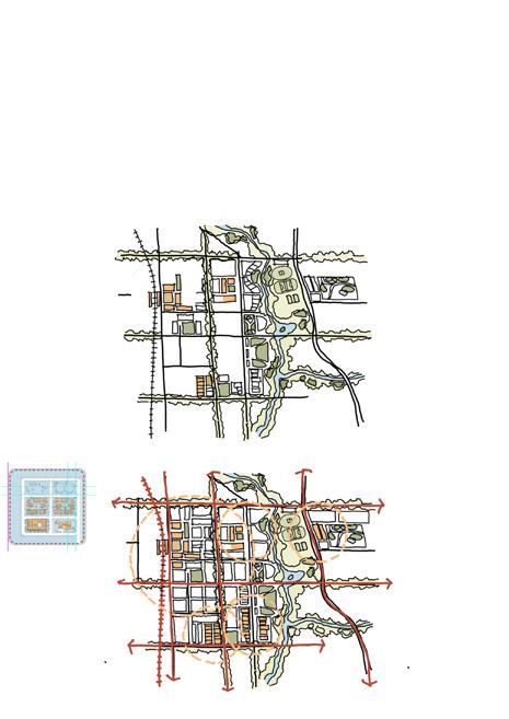
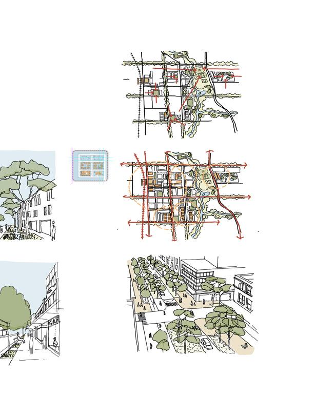
4.1 Urban structure
Urban structure is the arrangement of streets, paths, blocks and lots, public open spaces, activity centres, neighbourhoods, blue-green grid and the interrelationship between all of these elements. The urban structure contributes to an area’s function and feel, and creates a sense of place.
Guiding principles
• Compact and diverse neighbourhoods are connected to good amenities and integrated with their surroundings.
• Appropriate densities are planned to support viability of local services and a range of transport option.
• Diverse housing options are provided in the right place and of the right type.
• Place-based risks are mitigated to enable resilient communities.
INFILL GUIDELINES
GREENFIELD GUIDELINES
1. Prioritise infill development adjacent to existing activity centres and transport hubs to take advantage of planned and/or existing infrastructure and amenities.
2. Ensure infill development will not impede longer term opportunities for higher density development in strategic locations.
3. Lot amalgamation is encouraged to give a greater efficiency of scale and better design outcomes.
4. Locate higher densities at block ends – where there are increased street frontages and opposite open space.
5. Direct infill development toward areas with minimal hazard exposure, ensuring that floodprone or environmentally sensitive areas remain protected from intensified development.
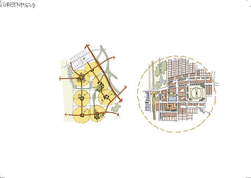
1. Create a subdivision and road layout to enable a mix of low, mid and high-rise housing forms in appropriate locations.
2. Create a network of centres to ensure that each dwelling is within walking catchment of neighbourhood or local centre.
3. Create a grid-like urban structure with a range of block lengths from 100m to 240m.
4. Block patterns and fine-grain street networks define legible, permeable neighbourhoods.
5. Planned densities are supported by appropriately scaled and composed streets, blocks and open spaces.
6. Distribute density across the greenfield release area to reach a minimum average gross density of 30 dwellings/ha* to increase densities within walking catchment of centres.
7. Plan for higher densities (45+ dwellings/ha) within 400m walking catchments of activity centres and transport hubs.
8. A mix of lot types and sizes is provided to support a range of dwelling types.
9. Locate density away from vulnerable areas such as flood prone land.
*Note: The minimum gross density of 30 dwellings/ha is based on the current Hunter Regional Plan 2041. In the event of any inconsistency between this Guide and a future regional plan, that the regional plan prevails.
4.2 Movement and connection
The movement network is the interconnected system of streets, roads and paths that connects our neighbourhoods to activity centres, workplaces, schools, parks and other services. A well-functioning movement network optimises walking and cycling access to these destinations.
Guiding principles
• An integrated transport network supports optimal connections and greater choice to be less reliant on car.
• Walking and cycling are prioritised, and safe and comfortable for people of all aged and abilities.
• Parking is minimised, adaptable and integrated.
• Walking is the natural first choice for local trips.
INFILL GUIDELINES
1. Ensure the road network is maintained and/ or upgraded in conjunction with any change in residential density.
2. Ensure the existing residential streets are upgraded to encourage walking and cycling.
3. Improve the connectivity of the existing street network to increase the attractiveness of noncar related transport.
4. Blocks with an appropriate length can benefit from laneways to avoid garage dominance in front streetscape and service access denied lots.
5. Car parking provision should be minimised and integrated across a precinct with more flexible requirements.
6. Laneways where provided are to be both functional and beautiful spaces - consider waste collection, traffic and pedestrian amenity.
GREENFIELD GUIDELINES
1. Create an interconnected street layout with regular block sizes and provides a choice of routes, allowing people to move easily and efficiently.
2. Provide an interconnected network for walking, cycling, public and private transport options.
3. Provide a finer grain network of pedestrian and cycle networks that link to other precincts and activity hubs like schools, shopping centres, recreation and sports facilities within the neighbourhood.
4. Locate new employment land on or adjacent to main roads
5. Orientate and integrate the street grid towards the blue–green grid, where possible.
6. Identify priority public transport corridors and infrastructure to ensure service reliability and operational efficiency.
7. Provide streets that are suitable in width for the proposed density and increased active transport and vehicle activity.
8. Provide walkable blocks and permeable street patters to accommodate greater amenity and support density over time.
9. Key land uses are co-located along the priority active and public transport corridors including high frequency bus routes.
10. Integrate key social infrastructure (e.g. schools) in locations with safe pedestrian, cyclist, vehicle access and access to open space, supported by efficient and reliable public transport connections.
4.3 Natural systems
The blue-green grid creates an interconnected network of ecological assets, waterways, wetlands and open spaces that supports biodiversity, recreation and waterway health. Natural systems connect our centres and neighbourhoods, and links them beyond our city boundaries into the rural landscape.
Guiding principles
• Blue-green grid is planned to maximise benefits for urban water management and urban greening.
• Key views, vistas and landscape features are optimised.
• Tree canopy supports sustainable, liveable and cool neighbourhoods.
• Water is retained in the landscape and water quality is improved.
1. Plant trees in the public domain to offset potential tree loss in the private domain.
2. Ensure additional street trees and landscaping are provided to improve local character of the area.
3. Retain and celebrate existing mature trees and landscape features.
4. Urban tree canopy is enhanced and supported in accordance with the following targets:
Note: Maitland Environmental Sustainability Strategy 2030 seeks a target of 30% tree canopy in residential areas. Lower canopies in the private domain at higher densities is offset with increased tree canopy in the public domain.
INFILL GUIDELINES
GREENFIELD GUIDELINES
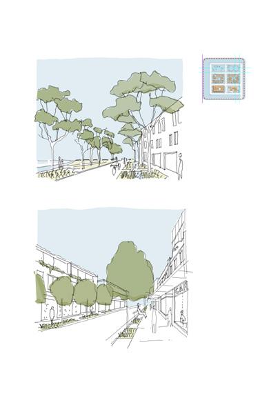
4.4 Public space
Public spaces are essential for the community wellbeing and provide opportunity for relaxation, recreation and socialising. They contribute to local character and sense of place by accommodating public use or recreation function such as parks and streets.
Guiding principles
• Public open spaces are high-quality, varied and adaptable.
• Streets are safe, active and attractive spaces for people.
• Public spaces are co-located and connected to bluegreen grid.
• Higher densities are supported in strategically located public spaces near centres and transport hubs.
1. Identify opportunities for new public space and/or improvements to existing public space.
2. Enhance the quality of the public space, where changes are required to existing streets to manage increased densities.
3. Preserve and enhance the existing public land to maximise community benefits – including upgrades to facilities in existing parks.
INFILL GUIDELINES
GREENFIELD GUIDELINES
4.5 Built form
Built form refers to the human-made environment and comprises all aspects of our surroundings including buildings, roads, parks, infrastructure and utilities. It is the space in which people live, work, study, recreate and visit on a daily basis.
Guiding principles
• Scale and massing of built form responds to the existing or desired local character.
• Heritage and culturally significance places are protected, conserved and enhanced.
• Sustainable and innovative design responses are addressed the challenges of changing climate and its adverse impacts.
INFILL GUIDELINES
1. Provide positive transitions and interfaces to local character, heritage items or conservation areas.
2. Locate apartments and higher density adjacent to existing open space or within 400m of an existing centre and transport hub.
3. Encourage small and irregular shaped lots to amalgamate with adjacent lots to ensure efficient development.
4. Locate new built form to retain and enhance the existing tree canopy to provide a quality public domain.
5. Locate and orientate buildings to engage with and provide passive surveillance over the public domain.
6. Development in existing centres to enhance the diversity of uses - as a places for retail, employment and housing.
7. Design needs to consider and minimise visual impact of car parking.
8. Recognise and respond to the established local character and setting of an area. Incorporate existing local character and built features into the design, e.g. heritage.
GREENFIELD GUIDELINES
1. Locate higher-density housing, such as apartments, closer to centres and transport hubs.
2. Within low-density neighbourhoods integrate low to mid-rise apartments at key locations (such as corners or adjacent open spaces).
3. Provide for a variety of heights and scales that integrates topography and urban structure.
4. Future higher density areas are identified and secured to develop later stages when the market matures and infrastructure is delivered.
5. Design lots to accommodate the appropriate building type to reinforce the intended density and character.
6. Design lots to facilitate safe and efficient vehicle and pedestrian access without street frontages being dominated by garages and parked cars.
7. Use built form to respond to local conditions –such as views, scenic and rural landscapes.
8. Ensure heritage buildings, cultural landscapes or places are identified and preserved.
9. Incorporate passive design techniques to reduce energy usage, greenhouse gas emissions, minimise waste and support walking, cycling and public transport.
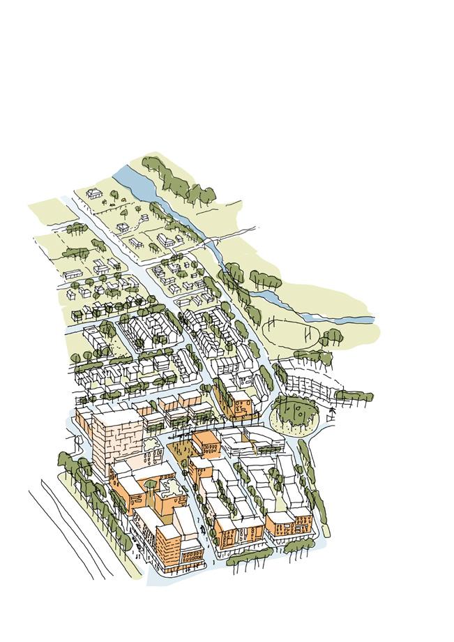
4.6 Creating new places - greenfield
Large lot residential on fringe
Bushland and recreation provides interface to rural
Lower density residential outside core area
Rural land
Regional park
Lower density further from
Terraces behind higher
Buildings define street edges
Train station
Employment land
Main transport links / highway
Major centres around transport infrastructure
Retain and enhance blue/green grid / passive recreation.
Neighbourhood centre
A series of connected walkable neighbourhoods
Local centre with school and health infrastructure
Main Street / Boulevard
Civic Square with mixed use and retail
Recreation park and open space
Higher density overlooking park
Community centre
Medium density
Low density at perimeter
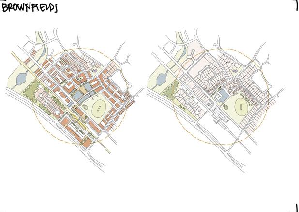
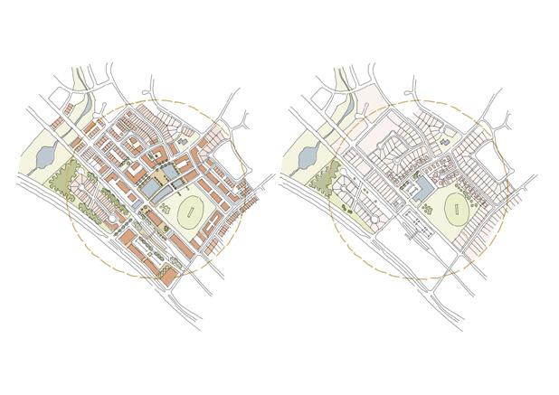
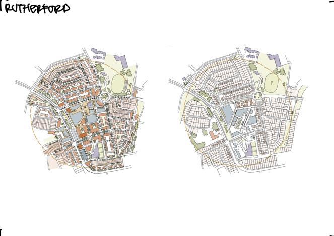
4.7 Re-inventing existing places - infill
Transform the existing urban fabric:
Transitioning to more infill development has many advantages and it needs to be guided in different neighbourhood contexts. Infill developments support compact urban form, more destinations within walking and cycling distance of homes, revitalising town centres, improving housing diversity by providing for greater
Isolated open spacedisconnected from blue/green grid
New connections to improve pedestrian and cycle permeability
Redevelopment around train station with commuter facilities
Proposed net residential density 40-60 dw/ha
Only one density - low single detached dwelling houses
No frontage to open space
Retail dominated by car park and internalised
Station entry dominated by car park and poor connectivity
Terrace houses as infill to perimeter
Townhouses / low rise apartments
Laneway to the rear of residential lots to avoid garage dominance streetscape
New civic square that is pedestrian focused for retail activity connected to the street
Higher density overlooking park
New street and lane providing active edge to park
Create civic places to encourage pedestrian activity around transport hubs
Open space with limited tree canopy Single density School
Box retail turns back on street
Local centre dominated by parking Low rise apartments
Open space defined by back fences
Commercial uses with poor pedestrian
Dual occupancies to perimeter Mid rise terraces
Create new pedestrian connection to increase accessibility
Tower forms define entry to centre
Commercial large format retail strengthen locality as a destination
Terraces overlook open space
Increased tree canopy
Community building anchors public space
Mid-rise apartment buildings
New dwellings have frontage to park
Reinforce existing community facilities
Landscape setback to highway
AHURI: Gilbert, C., Rowley, S., Gurran, N., Leishman, C., (2020) Urban regulation and diverse housing supply.
Government Architect NSW (2017), Better Placed Integrated Design Policy.
Committee for Sydney (2016), Making Great Places - Density Done Well.
LANDCOM (2011), Residential Density Guide.
LANDCOM (2011), Reference Chart: Residential density and planning controls
LANDCOM (2014), Housing Diversity Guide
Maitland City Council (2020), Maitland Local Strategic Planning Statement 2040+.
Maitland City Council (2023), Maitland Local Housing Strategy 2041
NSW Department of Planning, Housing and Infrastructure (2013), Housing choice and affordability in growth areas: Dwelling Density Guide
NSW Department of Planning, Housing and Infrastructure (2015), Apartment Design Guide
NSW Department of Planning, Housing and Infrastructure (2018), Greater Newcastle Metropolitan Plan 2036.
NSW Department of Planning, Housing and Infrastructure (2020), Low Rise Housing Diversity Design Guide.
NSW Department of Planning, Housing and Infrastructure (2022), Hunter Regional Plan 2041.
NSW Government (2025), Low and Mid-Rise Housing Policy.
5. Appendix
Case studies
This section looks at a selection of recently completed residential developments at different densities relevant to the Maitland context. These include examples of successful developments at different scales and different configurations from dual occupancies, terraces, shop top housing and precinct development for new communities.
Each case study examines its location, context, character, built form, housing typology, density and other design responses to the site constraints and how they are related to Maitland context.
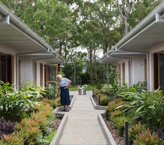
Seniors living/ Co-living 7. The Living Quarters, Marsfield, NSW
Townhouses 8. Darcy on Banks, Maitland NSW
Shop-top apartment 9. Twenty Hall, Bondi NSW
LARGE SCALE DEVELOPMENT
1750 - 1 HA
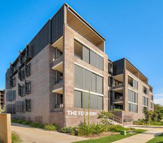
Residential flat building 10. The Foundry, Newcastle NSW
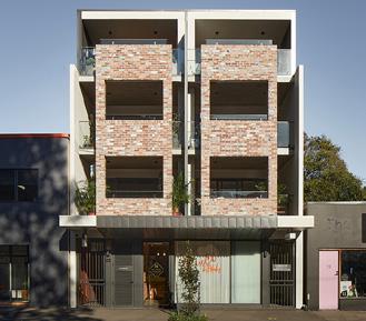
Shop-top apartment 11. Balfe Park Lane Apartments, Brunswick East VIC
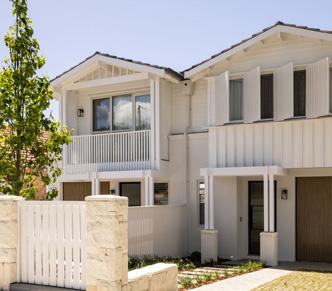
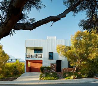
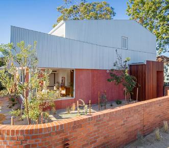
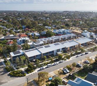
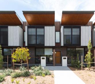
Townhouses 12. The Terrace Green, White Gum Valley WA
PRECINCT SCALE DEVELOPMENT 1 HA+
NSW
Hybrid 13. Hamilton’s Corner, Lindfield NSW
Precint Medium 14. The Fettlers, Whitebridge NSW
Precint Large 15. Edmondson Park, South West Sydney
5.1 Small scale development
DUAL OCCUPANCY
WOODLAND DUAL OCCUPANCY
Traditional Owners: Gadigal People
Location: Balgowlah, NSW
Architect: Smith & Tzannes
Developer: Styleness Properties
Photo: Styleness Properties
DENSITY DATA
Site Density 31 dw/ha
Site Area 629 m2
Number of Dwellings 2 x 3 Bed
Council Northern Beaches
Project Year 2022
How does the development fit in its context?
Woodland Street Dual Occupancies fit cohesively into the neighbourhood’s streetscape with gablestyle roofs, consistent setbacks, and driveways aligned to the streetscape. This design maintains the existing character and density of the surrounding area. The three-bedroom residences both have ample garden space. The development’s location ensures a short walk to the local shopping district and access to public transport integrating increased density to the existing neighbourhood.
How does the development provide good amenity?
The Dual Occupancies are well-designed, offering spacious three-bedroom homes with terraces and large private gardens. The inclusion of car parking for both residences aligns with the neighbourhood’s character. Situated in proximity to public amenities, shops, schools, local parks, and bushland, these residences provide easy access to essential services. Additionally, the convenience of nearby public transport facilitates commuting to the CBD and surrounding areas. With a focus on good internal amenity, these dual occupancies prioritize practical living while seamlessly integrating with the surrounding community.
How does the development relate to Maitland?
Woodland Street Dual Occupancies serve as a model for single-lot development in Maitland, effectively doubling the density of the site. The design responses to the character of the area, showcasing an approach that can be wellutilised in established urban areas with low-rise developments. It allows integration of increased density while maintaining the local character in residential areas.
Small scale development
SHOP-TOP APARTMENT
WICKHAM PARK APARTMENTS
Traditional Owners: Awabakal People
Location: Newcastle, NSW
Architect: Shac Architects
Developer: Foteff Property Group
Photo: Shac Architects
DENSITY DATA
Site Density 120 dw/ha
Site Area 500 m2
Number of Dwellings 6 x 3 Bed
Council Newcastle
Project Year 2020
How does the development fit in its context?
Wickham Street Apartments are visually interesting, adding to the neighbourhood’s appeal. Built to the boundary, they facilitate the development of surrounding buildings while maintaining a consistent scale with the neighbourhood. The rear lane provides off-street parking, eliminating driveways from the frontfacing aspect and improving the existing public space, contributing to street activation.
How does the development provide good amenity?
The Apartments offer convenient living with proximity to public transport, including Hamilton Station just a 5-minute walk away. The apartments feature thoughtful design elements, including cross-through layouts for improved ventilation, access to courtyards and north-facing terraces, as well as secure parking. The visually interesting building, constructed to the boundary, not only maximizes space but also allows for potential development of neighbouring sites. With commercial spaces underneath, the apartments overlook Hawkins Oval, offering a pleasant view and emphasizing good access to natural light. An internal lift ensures accessibility, making these spacious three-bedroom apartments a practical and well-connected residential option.
How does the development relate to Maitland?
This development is a good example of a single-site shop-top development. The strategic placement of increased density, complemented by the proximity of parklands and a local shopping district, ensures convenient access to local amenities. Additionally, the use of a rear access lane for car parking not only facilitates practical access but also holds the potential to enhance street activation in the surrounding neighbourhood. Given the diverse streets and laneways in Maitland, such an approach could be tailored to suit various sites within Maitland.
Small scale development
GEN Y MULTI
Traditional Owners: Whadjuk People
Location: White Gum Valley, WA
Architect: Cast Studio
Developer: LandCorp
Photo: Robert Firth
DENSITY DATA
Site Density 120 dw/ha
Site Area 250 m2
Number of Dwellings 3 x 1 Bed
Council Freemantle
Project Year 2013
MANOR HOUSE
How does the development fit in its context?
Gen Y Multi seamlessly integrates with its surroundings through landscaping that fits the existing context. The modern building form is softened by the brick landscaping walls. The building maintains sufficient setback in line with the existing streetscape. The corner site features one driveway per street frontage, ensuring practical access. Despite its single-dwelling appearance, Gen Y Multi cleverly consists of three units.
How does the development provide good amenity?
This development offers a compact and sustainable housing solution, providing three welldesigned 1-bedroom dwellings within a small site. The sustainable building incorporates solar power, PV cells, battery storage, and a 10,000L rainwater tank, achieving a ‘gold medal’ level of life cycle analysis by E-tool. Each apartment, ranging from 47 m2 to 50 m2, features generous private open space, good internal layouts, and natural northern light and cross ventilation. The shared central courtyard fosters a sense of community among residents, encouraging social and ecological interaction. This innovative approach to housing combines functionality, sustainability, and communal living within a small footprint.
How does the development relate to Maitland?
This manor house typology allows for three well-designed dwellings on a small corner lot. Cleverly constructed to appear as a single home addressing both street frontages, the development provides an example for increased density within Maitland’s low-rise areas or on sites with area constraints.
Small scale development
BAILEY STREET TERRACE
Traditional Owners: Awabakal People
Location: Newcastle, NSW
Architect: Smith & Tzannes
Builder: SNL Building
Photo: SNL Building
DENSITY DATA
Site Density 66 dw/ha
Site Area 454 m2
Number of Dwellings 3 x 3 Bed
Council Newcastle
Project Year 2018
How does the development fit in its context?
Bailey Street Terraces maintain a consistent setback with the street, adopting a traditional building form that complements the surroundings. Addressing both frontages, these terraces feature front and backyard areas, contributing to the neighbourhood’s visual appeal.
How does the development provide good amenity?
The Terraces development location allows close proximity to schools, a local shopping area, and cafes, providing residents with convenient access to amenities. With Adamstown train station just a 10-minute walk away, the development ensures easy commuting options. Each dwelling features welldesigned internal amenities, with internal storage and ample access to natural light. Each dwelling has private garden space and individual open areas. The development features a visually interesting form with variations between the three dwellings allowing good integration into the existing neighbourhood.
How does the development relate to Maitland?
Bailey Street Terraces demonstrate increased density on a small site area and offering decreased dwelling size while maintaining good internal amenities and providing ample private open space. Positioned in a well-connected neighbourhood near schools and local shopping in Adamstown, Newcastle - the development reflects the market desirability within the Hunter Region.
Small scale development
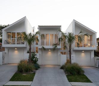
THE FLYNN TERRACES
Traditional Owners: Birpai People
Location: Port Macquarie, NSW
Architect: Chris Jenkins Design
Builder: Robert Newman
Photo: In Situ Studio
DENSITY DATA
Site Density 58 dw/ha
Site Area 509 m2
Number of Dwellings 3 x 3 Bed
Council Port Macquarie
Project Year 2023
How does the development fit in its context?
The Flynn Terrace development is in line with the street’s setback, mirroring the height and style of neighbouring structures. With a contemporary design, they take cues from nearby buildings for form and scale. Situated on a street with a range of medium development typologies, The Flynn Terraces blend in while contributing to the neighbourhood’s varied architectural landscape.
How does the development provide good amenity?
The Terraces feature a practical layout with openplan living on the lower floor and bedrooms on the upper level. Each dwelling is designed with a focus on natural lighting, with the provision of internal courtyards and voids within the development. The development provides ample private open space within the site with public open space at both Macquarie Reserve and Flynn’s Beach at walking distance.
How does the development relate to Maitland?
The Flynn Terraces exemplify efficient use of land, transforming a narrow single lot into three terrace houses. The front parking is mitigated by minimising the building width and introducing landscaping between driveways, a practical solution suitable for areas in Maitland lacking rear lanes for parking.
GROUND
5.2 Medium scale development
MULTI-DWELLING TOWNHOUSES
MAGGIE STREET
Traditional Owners: Awabakal People
Location: Mayfield East, NSW
Architect: Curious Practice
Builder: Built by Eli
Photo: Alex McIntyre
DENSITY DATA
Site Density 42 dw/ha
Site Area 950 m2
Number of Dwellings 3 x 3 Bed
Council Newcastle
Project Year 2023
How does the development fit in its context?
Maggie Street Development respectfully fits into the surrounding suburbs, maintaining the area’s heritage and character. It efficiently utilizes one large lot to achieve a fourfold increase in density, replacing a single home. The location of the development supports this increased density through good amenity. Maggie Street adds biodiversity through native planting and permeable surfaces.
How does the development provide good amenity?
The development comprises of four generous two-story houses, each thoughtfully designed to accommodate various occupant needs, including space for a growing family, home office, or guests. Each dwelling maintains a cohesive appearance as four single buildings, featuring ample private open space and designated planting areas. Internally, the well-designed layout includes a lower level with an open dining and lounge area, while the upper level encompasses three bedrooms, a living area, and a study. Additionally, each dwelling provides space for two cars. The replacement of lawns with planting enhances biodiversity and contributes to a more environmentally conscious design
How does the development relate to Maitland?
Maggie Street Townhouses serve as an example for well-designed and viable townhouse developments within the larger, long sites prevalent in Maitland. Featuring smaller, strategically located dwellings with both excellent internal and external amenities, the development reflects the market demand in the Hunter Region.
GROUND FLOOR
Medium scale development
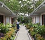
LIVING QUARTERS
Traditional Owners: Wallumedega People
Location: Marsfield, NSW
Architect: HA Architecture
Builder: Tower Projects
Photo: Clinton Weaver
DENSITY DATA
Site Density 12 dw/ha
Resident Density 47 dw/ha
Site Area 1700 m2
Number of Dwellings 2 x 4 Bed
Council Ryde
Project Year 2022
How does the development fit in its context?
The Living Quarters, located in a retirement village, offers residents easy access to care services and is conveniently close to the local bus routes. With a deliberate setback from the street line, the development maintains a consistent character with the neighbourhood. The Living Quarters development prioritizes practicality, accessibility, and environmental considerations within its surroundings.
How does the development provide good amenity?
The development adopts a well-designed floor plan that provides each resident with access to a private room, ensuite, and shared living spaces—aiming for a personalized ‘quarter’ for every occupant. This approach fosters a strong sense of community within and between the two buildings. The development prioritizes natural lighting throughout, creating a pleasant living environment. Sustainability is an important factor of the development, with features such as rooftop solar, rainwater tanks, and doubleglazed, openable windows. Parking at the front of the development allows for increased greenery on the site, steering away from an abundance of driveways often seen in townhouse style developments and embracing a concept reminiscent of on-street parking, rather than individual garages for each dwelling.
How does the development relate to Maitland?
Living Quarters presents an intriguing typology with potential applications beyond seniors’ living, offering possibilities for co-living purposes, particularly appealing for scenarios like housing students near a university or those affiliated with Maitland hospital. The development promotes a strong sense of community through shared central gardens and common spaces, fostering connection among residents. Its scale allows it to fit comfortably into a medium-sized lot within an existing neighbourhood and well-designed floor plan cleverly balances public and private spaces.
Medium scale development
DENSITY DATA
Site Density 46 dw/ha
Site Area 1714 m2
Number of Dwellings 6 x 3 Bed 2 x 2 Bed
Council Maitland
Project Year 2019
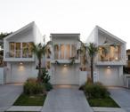
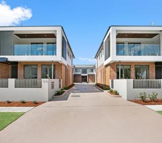
How does the development fit in its context?
Darcy on Banks integrates well with the street, maintaining the character of the area by following the same roof form and setback as a neighbouring heritage building. The building’s setback creates a front garden space and private open areas for the four dwellings at the front. With warm brick material on the lower level and a modern-style top floor, the development subtly contributes to the neighbourhood’s aesthetic. It provides density without overpowering the area’s scale and strategically relocates parking to a central area for a more sympathetic street frontage with just one driveway.
How does the development provide good amenity?
The development features modern living with openplan layouts that combine kitchen, dining, and lounge spaces. Its strategic location ensures convenient access to public transport, providing connectivity for residents. Comprising eight spacious 2-3 bedroom apartments, the development prioritizes ample storage and private open spaces. Lower-level apartments feature access to private garden spaces, while upper-level units have oversized outdoor terrace spaces. Situated across from local public open space, including King Edward Park, and near East Maitland train station and local shopping areas, Darcy on Banks provides a well-connected highly dense development.
How does the development relate to Maitland?
The Darcy on Banks highlights a successful townhouse typology within Maitland. The design responds to the existing character of the area and reflects the market demand for increased density within established urban areas. The typology makes use of a large site area providing eight dwellings located in a well-connected neighbourhood providing excellent amenity to each home. Given the depth and width of many existing lots within Maitland, such an approach could be tailored to suit various sites.
Medium scale development
SHOP-TOP APARTMENT
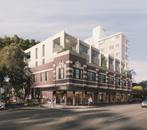
TWENTY HALL
Traditional Owners: Bidjigal, Birrabirragal and Gadigal People
Location: Bondi, NSW
Architect: Woods Baggot
Photo: Woods Baggot
DENSITY DATA
Site Density 108 dw/ha
Site Area 918 m2
Number of Dwellings 10 x 1-3 Bed
Council Waverly
Project Year Unbuilt
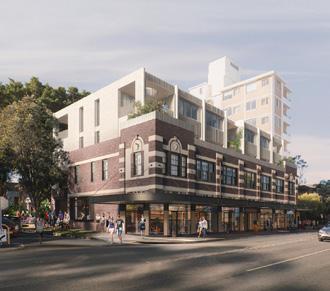
How does the development fit in its context?
Woods Baggot’s 222 Bondi Road development blends old and new seamlessly. Incorporating seven 1933 shopfronts, the design respects the area’s history. An existing mature fig tree on site is retained and becomes the focal point of a courtyard, providing shade. The materiality of the new addition allows for a modern architectural style whilst mimicking the existing building’s structure, creating a harmonious mix of old and new. Basement parking enhances street appeal and increases public space maximising the potential of the corner site.
How does the development provide good amenity?
The apartment development offers retail spaces on the ground floor, creating an open courtyard that extends the public space. Integrated landscaping enhances the surroundings and resident amenity. The design prioritizes natural ventilation, cross ventilation, solar aspects, and acoustics. It features a diverse range of one, two, and three-bedroom apartments with well-designed floor plans for ample storage and spacious living areas. Basement parking is available. Situated in the main Bondi shopping strip, the building provides easy access to public transport, cafes, grocery stores, and open spaces, supporting increased densification on site.
How does the development relate to Maitland?
Maitland has a strong existing heritage character within many of its local centres. Balancing the preservation of this heritage character whilst increasing density within these areas creates an opportunity for unique architectural typologies. ‘Twenty Hall’ is a successful example of this type of development. The design integrates seamlessly into the existing heritage building, respecting the original features by setting back from the existing street frontage and maintaining a reasonable scale. The shop-top apartment typology allows for an activated local centre whilst providing increased density to a heritage building, an approach that could be applied to many existing sites within Maitland.
GROUND
5.3 Large scale development
RESIDENTIAL FLAT BUILDING
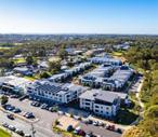
THE FOUNDRY
Traditional Owners: Awabakal People
Location: Newcastle, NSW
Architect: Stewart Architecture
Developer: BLOC Constructions
Photo: Domain
DENSITY DATA
Site Density 197 dw/ha
Site Area 4196 m2
Number of Dwellings 83 x 1-3 Bed
Council Newcastle
Project Year 2020
How does the development fit in its context?
The Foundry Apartments make use of the natural slope of the site, appearing smaller and less imposing in the public space and local shopping district. New street trees on the residential side enhance the surroundings. The five stories feature changes in materiality and facades, along with planting on the front facade. A cross-through link between Brunker Road and Date Street improves walkability and permeability in the neighbourhood. Located for convenient access to local amenities, The Foundry Apartments also contribute to increased neighbourhood density, offering potential for additional business opportunities and improved public infrastructure.
How does the development provide good amenity?
The Apartments adopt a strategic design, splitting the development into three separate buildings to enhance permeability and incorporate central courtyards and planting spaces. Situated with convenient access to various amenities, residents enjoy proximity to local shopping, the beach, bushland, and Newcastle CBD. The exterior features long-lasting materiality, ensuring durability.
How does the development relate to Maitland?
The Foundry apartment building typology spans across six existing lots along the middle of an urban block allowing for dual street frontage. This typology serves as a model that could be applied to sites in Maitland to enable higher density whilst increasing permeability within the existing urban fabric. The development is well located near a local centre and the basement parking enables increased public open space and footpaths across the large site. The typology provides an example of a thoughtful solution to altering an existing urban block, especially applicable to future infill developments.
Large scale development
BALFE PARK LANE
Traditional Owners: Wurundjeri
Woi-Wurrung
Location: Brunswick East, VIC
Architect: Kerstin Thompson
Client: Antipodean Land Developments
Photo: Derek Swalwell, Leo Showell
DENSITY DATA
Site Density 338 dw/ha
Site Area 2250 m2
Number of Dwellings 77 x 1-4 Bed
Council Merri-Bek
Project Year 2021
How does the development fit in its context?
Balfe Park Lane Apartments contribute to the community with a cross-through pedestrian walkway connecting the mixed-use commercial zone to a local park, enhancing accessibility. The development features lower-level commercial tenancies that engage with the streetscape, promoting a vibrant environment. Built to the boundary, it allows for potential future development of neighbouring sites. Offering a variety of dwelling types and apartment sizes, the project prioritizes flexibility and diversity to accommodate different resident needs. Addressing both street and laneway frontage, the design ensures passive surveillance to the street and incorporates a diverse façade for visual interest.
How does the development provide good amenity?
The Apartments prioritise amenity, housing diversity, sustainability, and community for their occupants. Each dwelling features dual aspects, offering outlooks to either Balfe Park or the internal courtyard. The clever design of four long building forms enhances views, daylighting, and cross ventilation throughout the apartments. The development achieves highlevel compliance with the Liveable Housing Australia Liveable Design Standards, ensuring a commitment to creating accessible, comfortable, and inclusive living spaces for residents.
How does the development relate to Maitland?
Balfe Park Lane provides an example of a shoptop apartment typology that connects both with the existing streetscape and parkland, providing excellent amenity to a higher density development. The development is successful due to its location, recognising existing amenities within the locality and transforming these parameters into a successful place-based building design. Similar approaches could be used within the Maitland context where higher density developments are located in areas with high existing amenity and access to public open space.
GROUND FLOOR
Large scale development
TERRACE GREEN
Traditional Owners: Whadjuk people
Location: White Gum Valley, WA
Architect: MDC Architects
Builder: Bruce Construction Design
Photo: Robert Frith, Acorn
Landscape: Aspect Studios
DENSITY DATA
Site Density 51 dw/ha
Site Area 5,490 m2
Number of Dwellings 28 Terrace Houses
Council Freemantle
Project Year 2023
How does the development fit in its context?
The Terrace Green development aligns its buildings in a stepped form along the street-facing façade. Landscaping is incorporated for both the dwellings and the street façade, integrating into the site and promoting biodiversity. The scale of the development fits well with the existing neighbourhood character. Garden spaces are brought forward with resident parking to the bank to improve the public realm.
How does the development provide good amenity?
The development stands out with its well-designed floor plans and durable building materials, ensuring longevity. Each terrace within the development provides residents with access to private open space and convenient off-street parking. Despite being compact, each dwelling is thoughtfully designed, with an average of 2/3 interior living space and 1/3 exterior garden space, balancing functionality and increased biodiversity.
How does the development relate to Maitland?
This development is a good example of a low scale development applied to a large site area, a typology that could be used successfully within both an infill and greenfield context. The development has a strong focus on affordable materiality, simple well-designed diverse dwellings and increased sustainability in the public domain through substantial landscaping. All factors which are valuable to the context of Maitland where there is a strong focus on increased housing diversity, affordability and sustainability.
GROUND FLOOR
Large scale development
HAMILTONS CORNER
Traditional Owners: Ku-ring-gai People
Location: Lindfield, NSW
Architect: Bates Smart
Builder: Grindley Construction
Photo: Brett Boardman
DENSITY DATA
Site Density 58 dw/ha
Site Area 3960 m2
Number of Dwellings 23 x 1-2 Bed
Council Ku-Ring-Gai
Project Year 2015
HYBRID
How does the development fit in its context?
Hamilton’s Corner hybrid development is characterised by a low scale yet high density, featuring 23 dwellings across two stories, including 7 terraces and 16 apartments. The setback from the street on all frontages allows for substantial planting in the public space, softening the development. Basement parking is efficiently provided through a single driveway, optimising space. The modern building form is softened by the materiality, with expansive timber roofs providing shading to the development and creating warmth.
How does the development provide good amenity?
The development prioritizes well-designed dwellings, each featuring a spacious floor plate and ample storage. Ensuring a quality living experience, every dwelling enjoys private open space. With a dual aspect design, terraces are cross-through, and each apartment functions as a corner unit, facilitating optimal daylighting and cross-ventilation. Residents benefit from close access to a university and local bushland, providing increased public space. Additionally, the convenience of a local bus line and shopping center in proximity allows the increase in density on the site.
How does the development relate to Maitland?
This development is an example of a hybrid typology suitable for block ends within existing or greenfield neighbourhoods, typically spanning 4 to 5 lots. This typology is advantageous to the Maitland context in its flexibility where the building form and dwelling count can be adjusted according to existing lot availability and building scale requirements. It could be utilised in various sites within Maitland where the apartment aspect of the typology is located facing a local centre and tapers off to the terrace typology as it moves towards a lower scale residential zone.
GROUND FLOOR
5.4 Precinct scale development
PRECINCT MEDIUM
FETTLERS WHITEBRIDGE
Traditional Owners: Awabakal People
Location: Whitebridge, NSW
Architect: Smith & Tzannes
Builder: SNL Building
Photo: SNL Building
DENSITY DATA
Site Density 38 dw/ha
Site Area 2.4 ha (9 lots)
Number of Dwellings 92 x 1-4 Beds
Council Lake Macquarie
Project Year 2020
How does the development fit in its context?
The Fettlers Lane development in Whitebridge aligns with its surroundings by placing various dwelling types appropriately. Shop-top apartment buildings are located along the existing street frontage, which transition vertically into two stories of apartments and move towards terraces and dual occupancies in the residential area of Whitebridge. A new roadway divides the development into lots, accommodating high density while showing respect for the surrounding bushland. This approach ensures a fitting integration of the Fettlers Lane development into the context of Whitebridge.
How does the development provide good amenity?
The development in Whitebridge prioritises welldesigned dwellings, each featuring either onsite or basement parking for convenience. Residents benefit from access to private open space, ensuring a comfortable living experience. Additionally, the development considers public open space, strategically located within the development area, allowing for footpaths and street trees. This ensures that while the dwellings are compact the residents have access to vital local amenity.
How does the development relate to Maitland?
Fettlers Lane serves as a relevant example of a medium sized precinct development featuring a diversity of dwelling typologies and successful small commercial zone. It is a well-planned precinct with increased density to the street frontage and creation of maintained public open spaces providing additional amenity for its residents.
Precinct scale development
PRECINCT LARGE
EDMONDSON PARK
Traditional Owners: Darug/Dharug, Dharawal and Gundangara people
Location: Edmondson Park
Developer: Landcom
Client: Landcom
DENSITY DATA
Site Density 9.9 dw/ha
Site Area 827 m2
Number of Dwellings 8,200
Council Liverpool & Campbelltown
Project Year 2012 - 2029
How does the development fit in its context?
Edmondson Park, a suburban development in southwest Sydney, emerged on land formerly owned by the Ingleburn Army Camp. Positioned 40 km from central Sydney, it stands as the first precinct planned and constructed under the New South Wales Government’s South West Priority Growth Area strategy, initiated in 2005 to sustainably manage urban expansion on Sydney’s fringes. The development aims to create a distinctive and sustainable community, preserving natural and heritage features while accommodating over 25,000 people. Edmondson Park will feature a combined primary and secondary school, recreational facilities, and 150 hectares of regional open space. Its town centre is strategically designed around a bus and rail interchange.
How does the development provide good amenity?
The development is strategically planned around efficient public transport infrastructure, including a train line and bus services. This forward-thinking development incorporates a diverse range of dwelling types to cater to varied housing needs. With a central commercial core and a focus on creating a diverse range of employment opportunities, Edmondson Park aims to foster a balanced and self-sufficient community. The densities within the development are concentrated around the transport zones, ensuring accessibility and convenience for residents while promoting sustainable urban planning practices.
How does the development relate to Maitland?
Edmondson Park’s, with its well-planned town centre and public transport integration, provides an example for future greenfield projects in Maitland. Emphasising diverse dwelling options, the development maintains differing levels of density whilst preserving extensive bushland and parks. Edmondson Park employs a Development Control Plan (DCP) to regulate growth, selling super lots for controlled residential and commercial developments.