Echoes of Permanence - Luan Fontes | Portfolio 2025
fragments of continuity in a world of change
luan fontes echoes of permanence
GOAL
Gensler Fellowship
ABOUT ME
Hey! As you already know my name is Luan Fontes. I’m currently living in Manhattan, New York City. I’m passionate about cinema, science, cities, movement, music, art and if you ask me for a book, I’ll probably have one in hand. I love swimming, surfing, dancing and discovering new places. Currently, I’m completely obsessed with “The White Lotus” and the cinematographic work of Hayao Miyazaki, I have also been learning Japanese. See you later!
NAME ORIGIN CONTACT YEAR SCHOOL VISA
luan fontes rio de janeiro, brazil luanfontesofficial@gmail.com third year student porto school of architeture USA F-1 student / J-1 intern / B-2 - business
EDUCATIONAL HISTORY
Columbia University Exchange Student 1 year program (In person) 2025.
Porto School of Architecture
Bachelor of Architecture 3rd year, 2021 (In person) 2025.
Norman Foster Fellowship Sustainable and Energy Program Madrid, Spain (In person) 2023.
27th World Congress of Architects Summer School Program. Rio de Janeiro, Brazil (Online Program) — 2022
VOLUNTEERING
People for the Ethical Treatment of Animals Activist Team — 2020.
Greenpeace Activist Team 2019.
EXPERIENCE
Bjarke Ingels Group
Architectural and Urban Design Assistant New York, United States — 2023.
Skidmore, Owings & Merrill Shadower New York, United States — 2023.
Building Information Modeling
Alvaro Siza + Souto Moura Architects
Construction Design Assistant Porto, Portugal — 2023.
Columbia Climate School
LECTURES
Responsive Cities Institute
The experience of space in the learning process and the practice of architecture competitions. Rio de Janeiro, Brazil.
Center for Resilient Cities Research Intern (In person) 2024.
MOOD Design Museum
Project “Out of sight” exhibited in the MOOD Design Museum, Como, Italy.
Dwelling in transition: Experiences from lockdown
Project “New Anusual” exhibited in the Dwelling in transition: Experiences from lockdown, Porto, Portugal.
European Innovation Academy
Project “Groof & Co” exhibited in the European Innovation Academy, Porto, Portugal.
Archdaily Brazil
Project “Out of sight: Sustainable Social Building” published in the Archdaily.
Daily Architecture Winners
Project “Out of sight” published in the Daily Architecture Winners.
Architecture Competitions
Project “Out of sight” published in the Architecture Competitions.
32th Arquisur
Project “Out of sight” published in the 32th International Arquisur.
A’ Design Awards
Project “Out of sight” published in the A’ Design Awards.
Porto School of Architecture
Project “Out of sight published in t he Porto School of Architecture.
Design Educates Awards
Project “Out of sight” published in the Design Educates Awards.
V2COM Newswire
Project “Out of sight” published in the V2COM Newswire.
American Institute of Architects
Project published “Out of Sight” by The American Institute of Architecture
ELLE Design
Project “Out of Sight” published by ELLE Design.
Young Visionary Architects Awards
Winner in the first stage in the Young Visionary Architects Awards in the Mixed Use Category with the project “Out of Sight”
SOFTWARE & HANDMAKING SKILLS
Tubądzin Design Awards
First Place in the first stage of the international award with the project “Out of sight” in the Young Power Category
First Place in the Grand Prix of the international award with the project “Out of sight” in the Young Power Category
Art Films Awards
Honorable Mention in the international award with the architecture film “New Annusual” in the short film Category
A Design Awards
Silver Award Medal in the international award with the project “Out of sight” in the Sustainable Design category.
Design Educates Awards
Honorable Mention in the international award with the project “Out of sight” in the architectural design category.
World Architecture Awards
Winner in the international award with the project “Out of sight”.
Green Product Awards
Winner in the international award with the project “Out of sight”.
Heathly House, Heathly City Competiton
Winner of the internacional competition in the public equipment category with the project “Out of Sight”.
Moneyshot Challenge
Winner in the international challenge with the project.
32th Arquisur
Nominated and Finalist in the international award with the project “Out of sight”.
Green Concept Awards
Winner in the international award with the project “Out of sight”.
Eduwik Architecture Excellence Awards
Second Place in the international award with the project “Out of sight” in the Mixed Use Category
American Institute of Architects
Honorable Mention in the Force of Mejaure Competition with the project “Out of Sight” in the Student Category.
Inspireli Awards
Winner in the international award with the project “Out of sight”.
Young Visionary Architects Awards
Winner in the second stage in the Young Visionary Architects Awards in the Mixed Use Category with the project “Out of Sight”
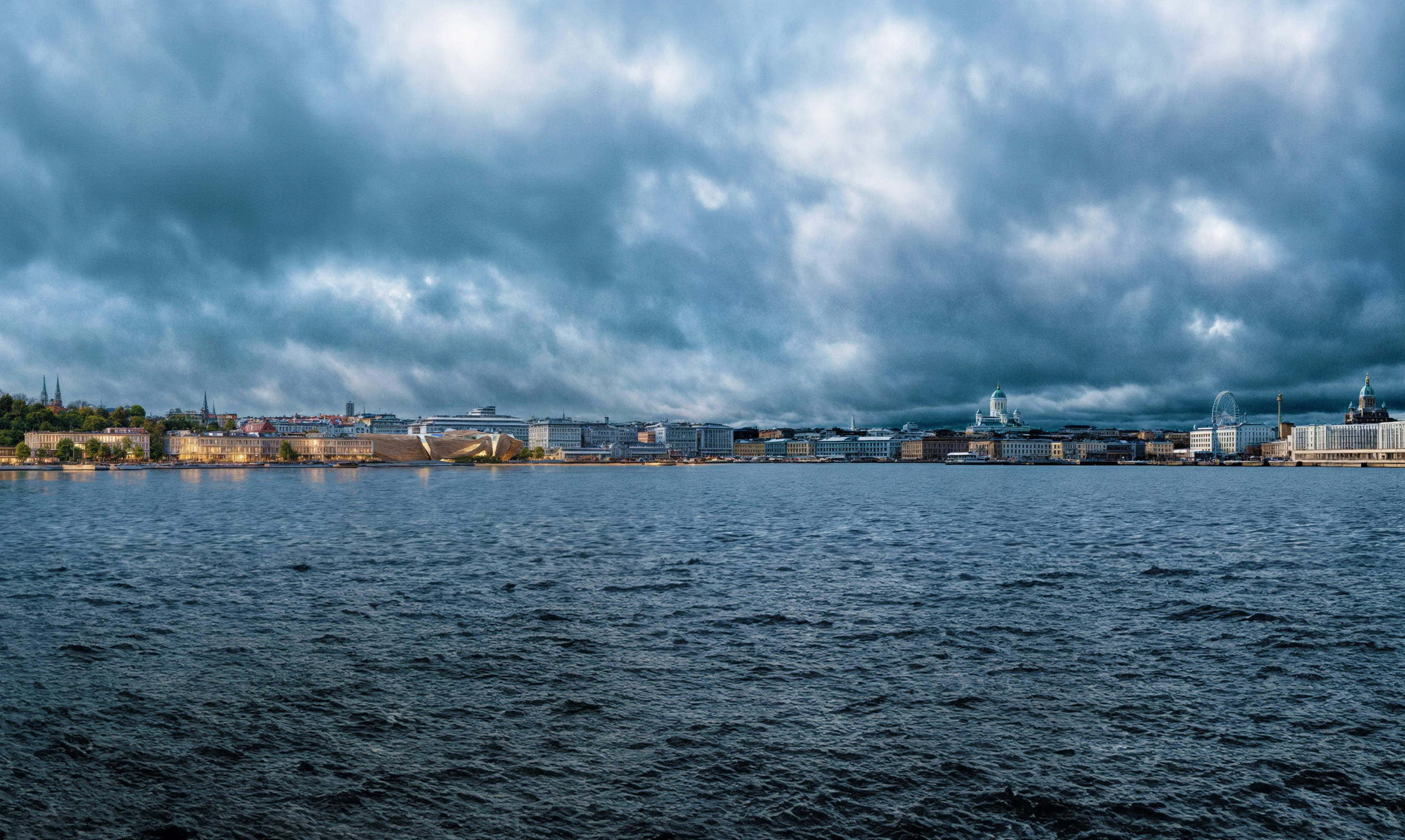
Helsinki Design Museum Competition
Force of Nature: Museum of Design Masterplan in Hensinki, Finland. Team Project.
Bjarke Ingels Group
Bayside Miami Masterplan in Florida, United States of America. Team Project.
Norman Foster Foundation
Crossing Lava: The revitalization of La Palma Island in the Canary Island, Spain. Solo Project.
Bjarke Ingels Group
Governors Island Energy Hub in New York, United States of America. Team Project.
Reuse the Fortress Competition
The light inside: Net-zero Microhome in Aosta Valley, Italy. Solo Project.
Cultural Winnery Competition
Winnery Complex and Restaurant at Podere Fedespina, Italy. Solo Project.
Columbia University
Urban Web: Integrating Scale, Sustainability, and Equity in New York, United States. Solo Project.
Large Scale Infrastructure Project in Porto, Portugal. Team Project.
Here I seek to explore and articulate the substance of my projects: their ethos, underlying metaphors, intricate details, and the interplay of superficial and natural elements that collectively shape them into enduring expressions of permanence
Alvaro Siza + Souto Moura Architects
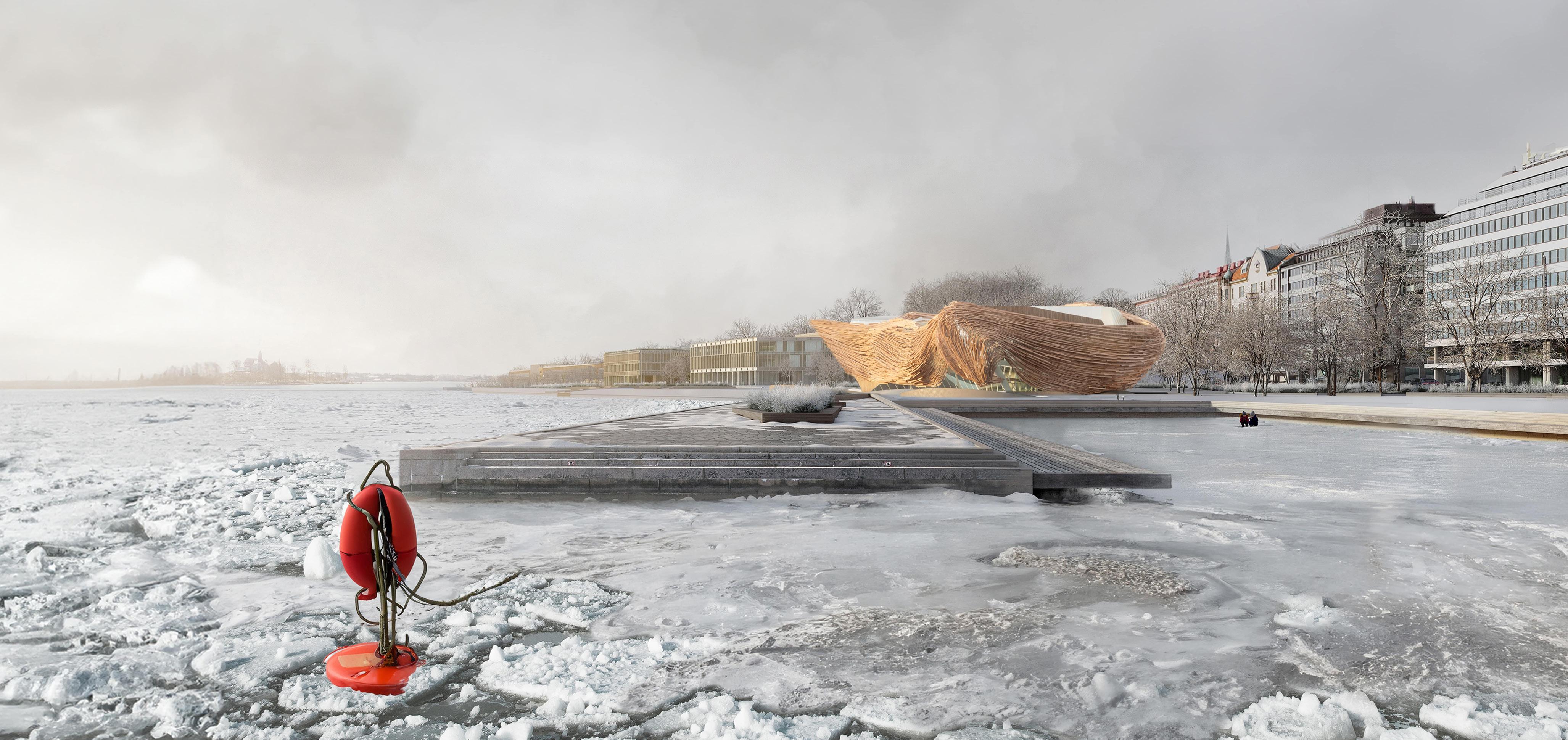
Force of Nature
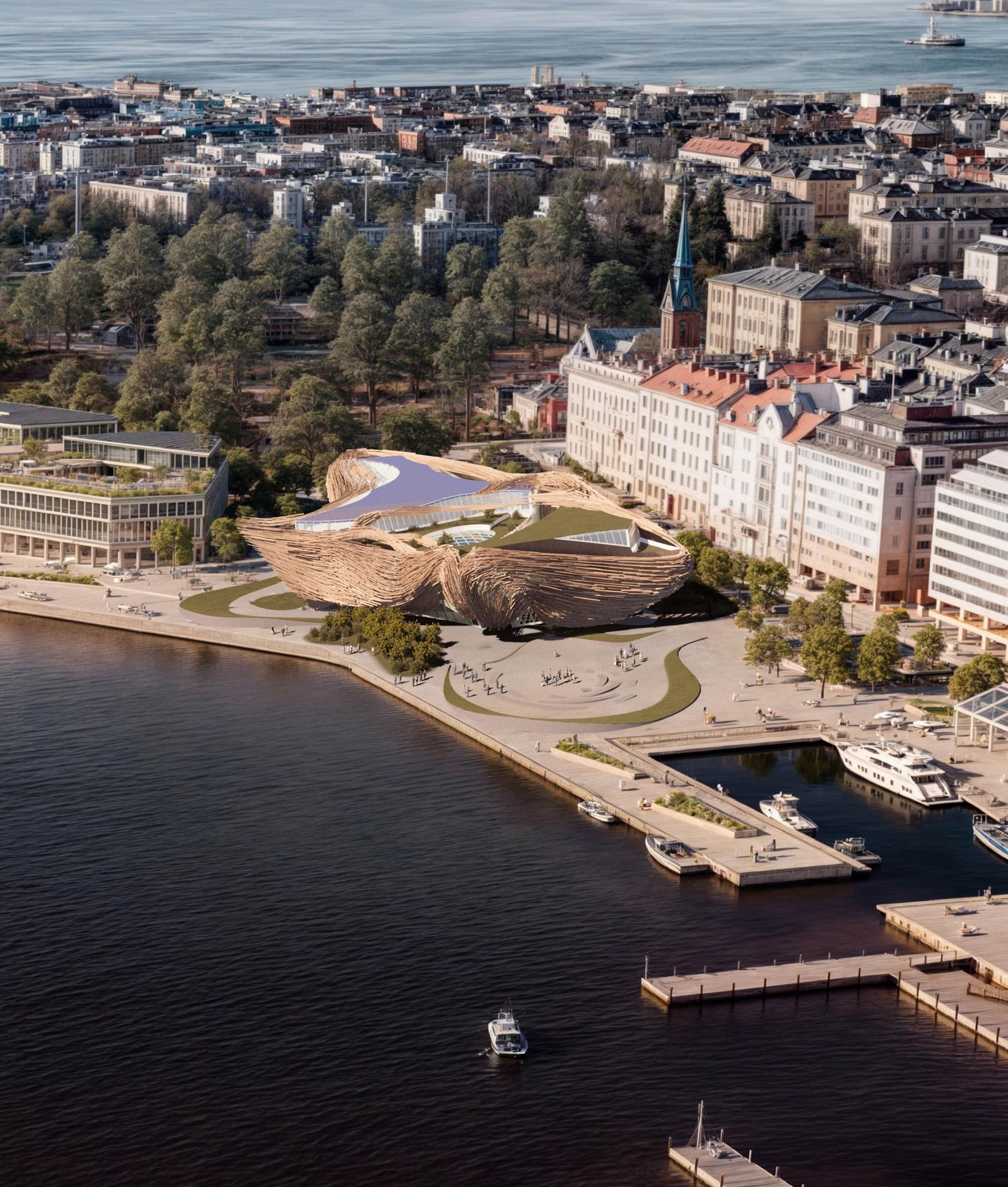
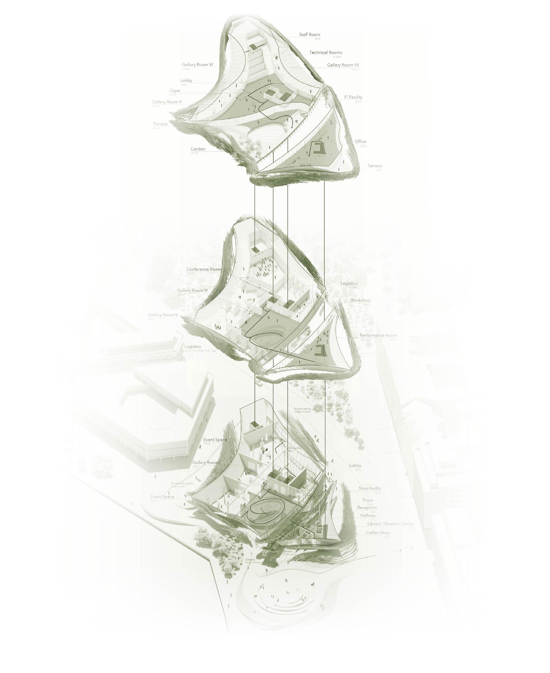
Helsinki Museum Design Competition
Sustainable Cultural Center Masterplan in Finland. Team Project.
Team: Andreas Palfinger (MAD/ZHA Architects), Ana Cyano (BIG/NYC), Nele Herrmann (BIG/NYC), Aryaman Garg (BIG/NYC), Felix Wong (SOM/HK), Riccardo Rivano (OMA/MVRDV), and Luan Fontes (BIG/NYC).
Size: 86,000 SF. Budget: 162 MI USD.
Design Proposal
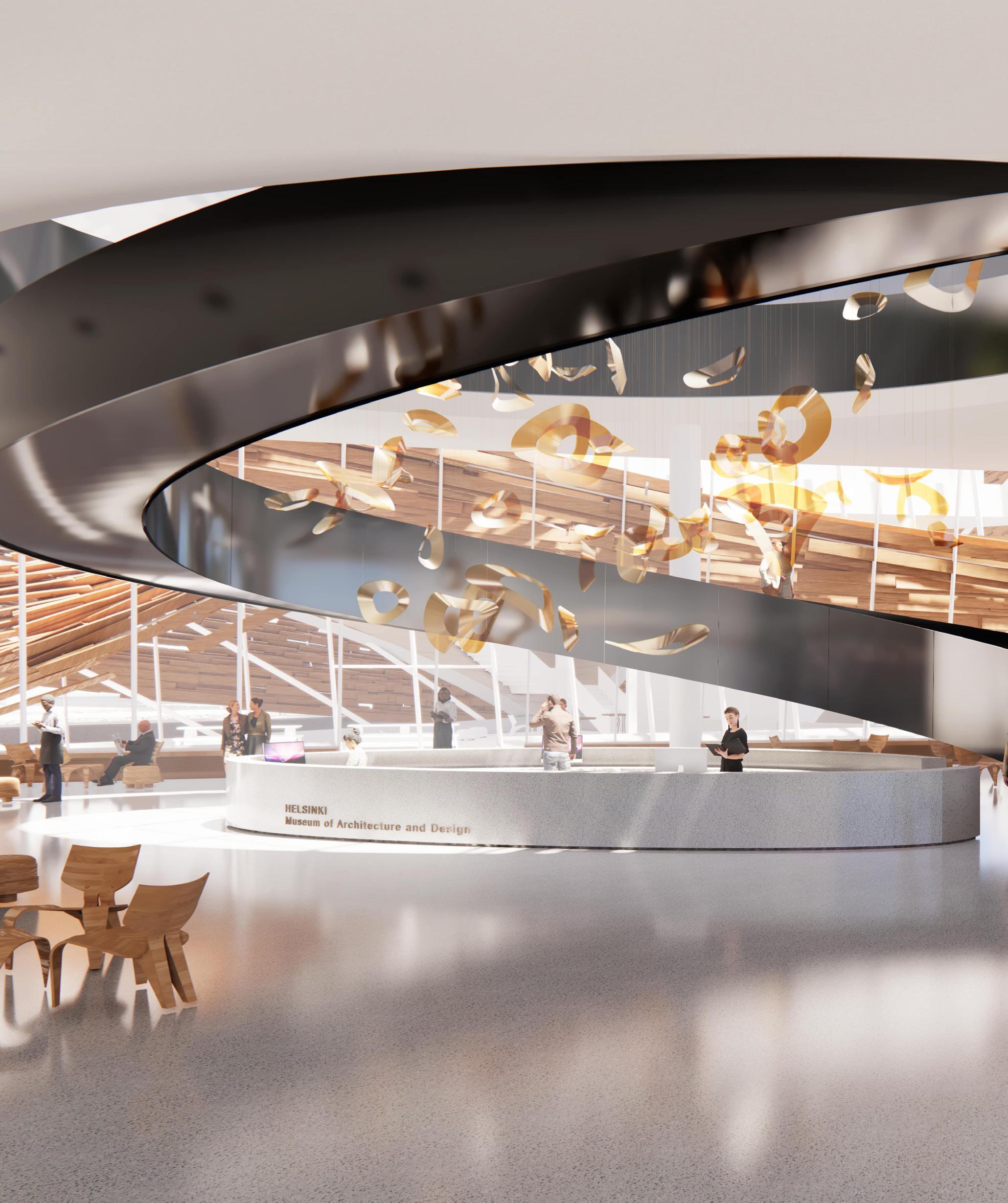
The project seeks to redefine the connection between the new Helsinki Design Museum and the city by embracing a forward-thinking approach that dissolves the conventional boundaries between public and private spaces, as well as the traditional role of a museum. Our vision emphasizes the innovative use of exterior spaces, blurring the distinction between built and unbuilt environments.
Inspired by some of Finland’s most intriguing cultural movements, our project captures the essence of local vision while blending it with the diverse perspectives of our multicultural team. The design concept emerged naturally, embodying the contrast between a cold, icy interior and a warm, woven exterior shell. This juxtaposition reflects the project’s dynamic creating a structure that resonates both visually and symbolically. By drawing from Finland’s rich heritage and integrating global ideas, the design not only honors the local context but also invites universal engagement, making the museum a beacon of inclusivity, creativity, and innovation.
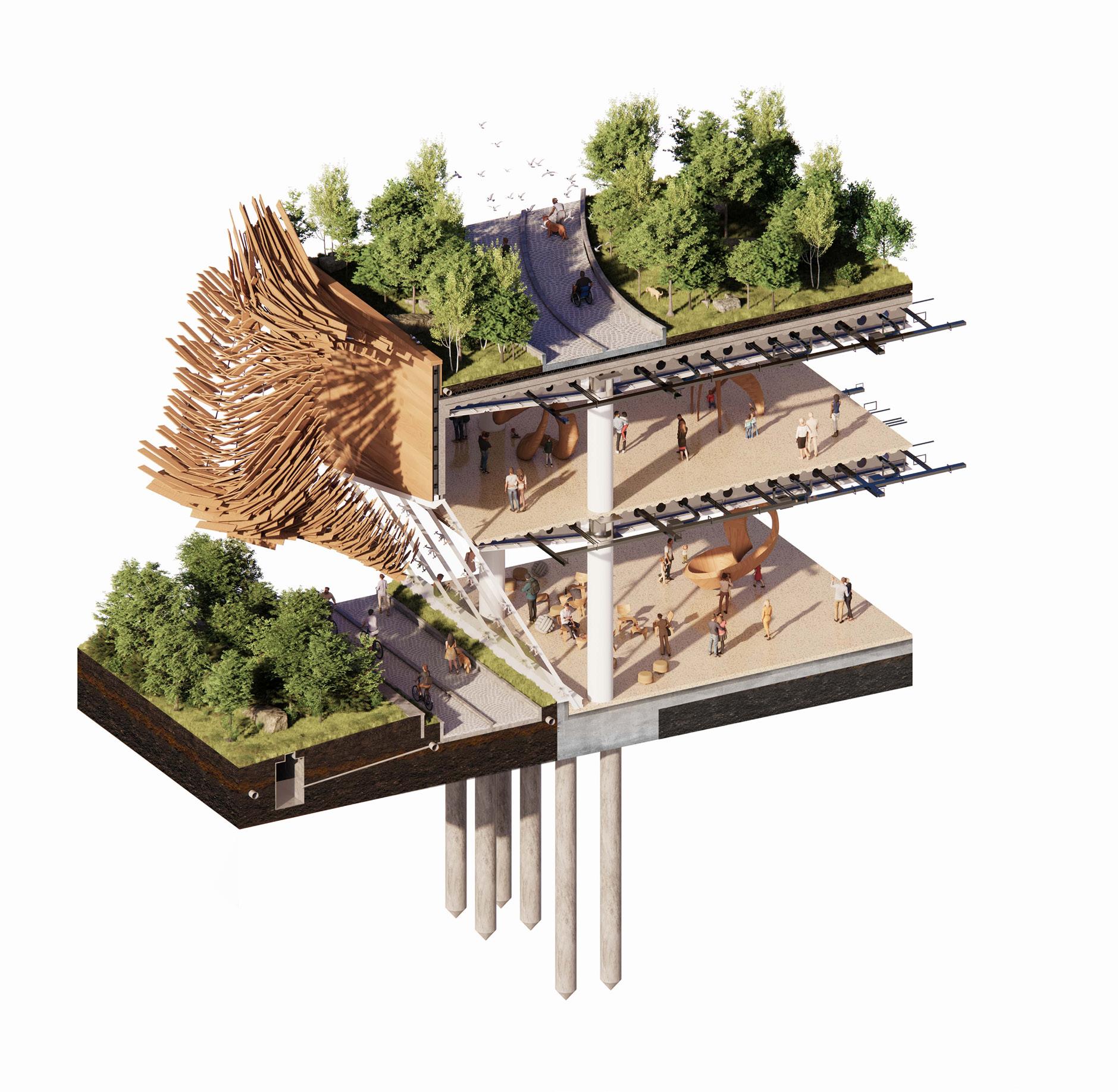
Our design concept draws from classical elements of Finnish culture, such as the abstraction of traditional fabrics, woven baskets, and the fluid movement of schools of fish which we call fast-paced design. The location’s proximity to water, with free-flowing fish and the contrast of a cold winter, served as an inspiration. Whether viewed from 1 meter or 100 meters away, the building’s facade with more than 20,000 pieces of recycled wood appears to be in constant motion, reinforcing its dynamic presence. The ever-changing play of light and shadow across the surface further enhances the sense of fluidity, mimicking the fishing.
The building features cutting-edge HVAC systems for optimal climate control, passive solar design to maximize energy efficiency, and rainwater harvesting integrated with flood-resistant landscaping to address environmental challenges. With 80% of materials locally sourced, the construction significantly reduces its carbon footprint while celebrating Finnish architectural heritage through its thoughtfully woven exterior, harmonizing seamlessly with the surrounding urban and natural environments. Spanning 24 months for design and 52 months for construction, the project emphasizes sustainability at every stage.
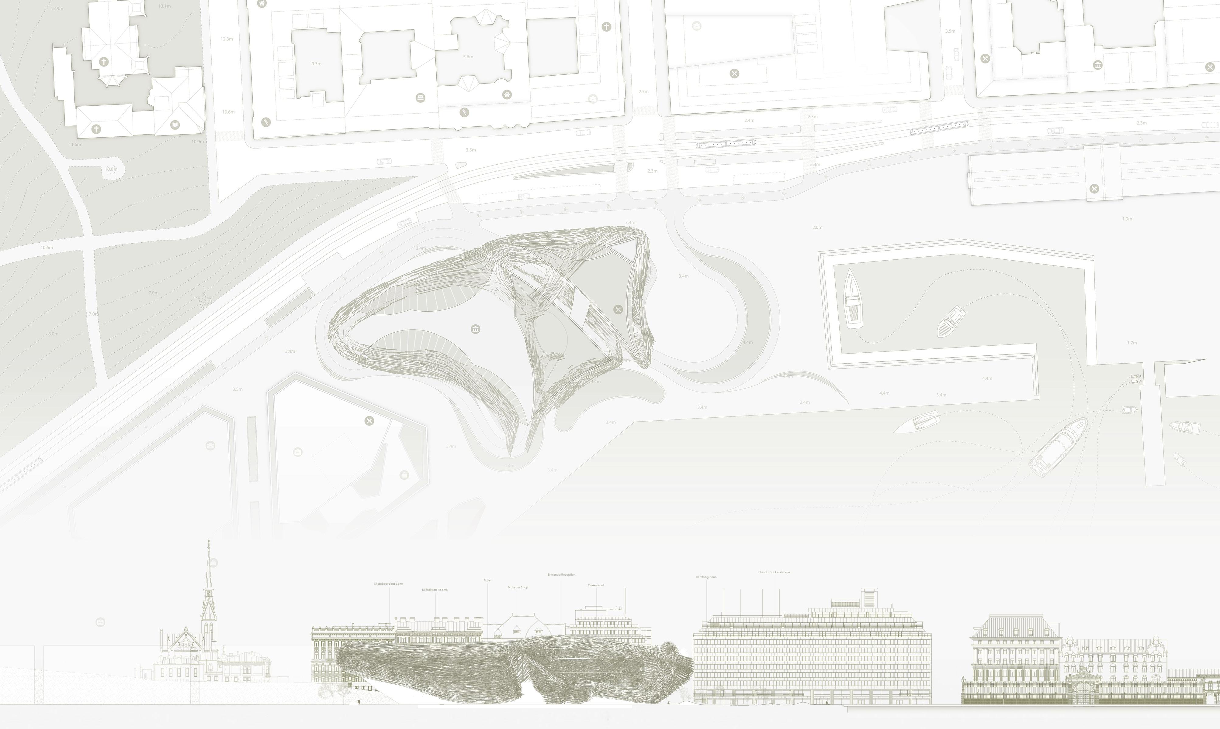
Circulation and Programming
Diagram
Facade Axonometric Section
Scale: N/A
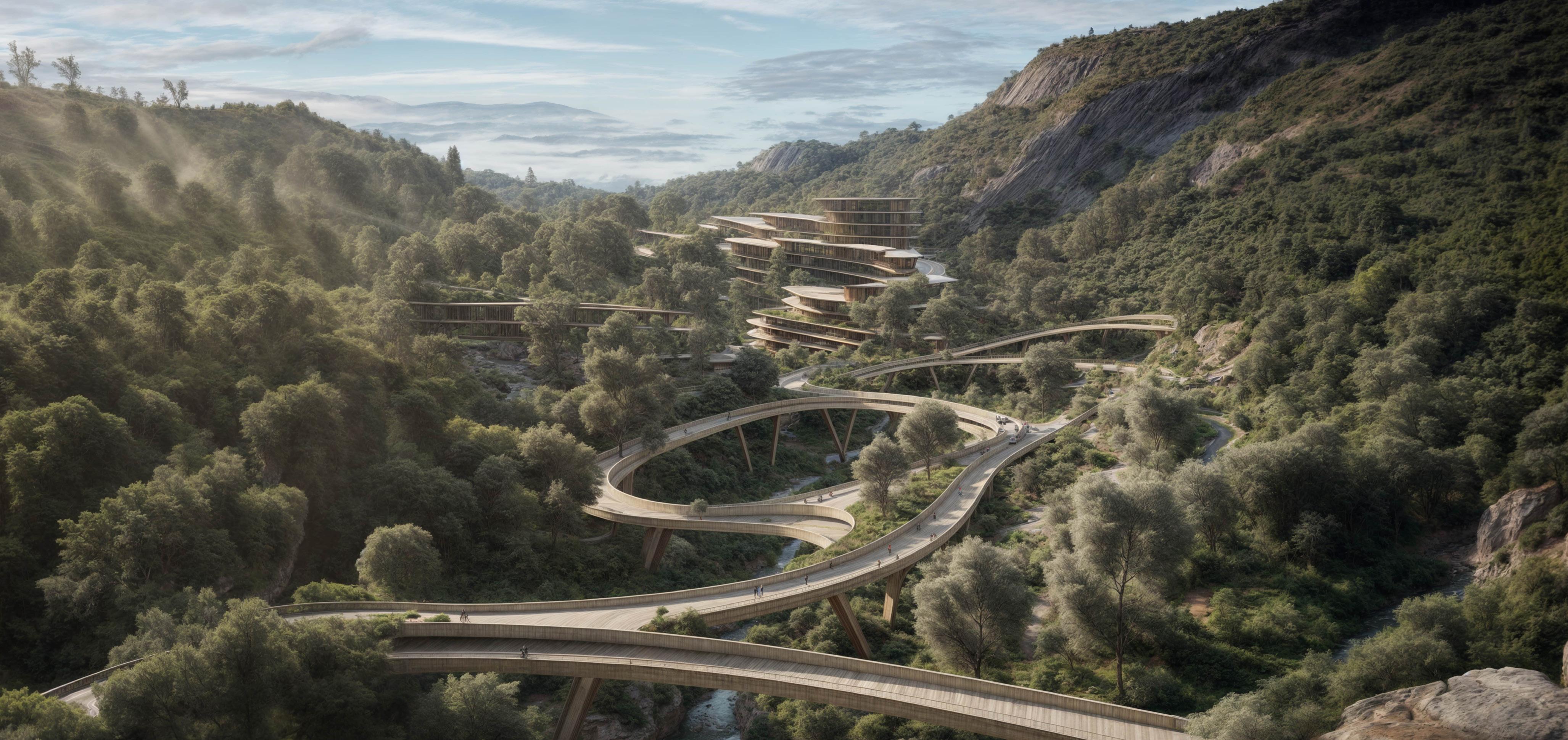
Crossing Lava
Norman Foster Foundation, Madrid Headquarters Resiliency plan for La Palma Island, in Spain.
Mentors and Professors: Norman Foster (Architect, Pritzker Winner), Ali Malkawi, (Founding Director, Center for Green Buildings and Cities, Harvard University), Christoph Reinhart, Director, Building Technology Program, MIT), Hashim Sarkis, Dean, School of Architecture and Planning, MIT), Victor Viña, Associate Professor, School of Design, Pratt Institute, New York, NY.
Size: 3,210,000 SF Budget: 2 BI USD.
Design Proposal
La Palma, a jewel among the Canary Islands, graces the Atlantic Ocean off the northwest coast of Africa, proudly belonging to Spain. As the fifth-largest and northwestern-most island in the archipelago, it boasts a captivating circular expanse spanning 28 miles.
The island spans approximately 28 miles in diameter, characterized by its nearly circular shape and remarkable geographical diversity. Renowned for its natural allure, verdant forests, and volcanic landscapes, the island stands as a testament to the splendors of the nature. La Palma emerges from volcanic origins, its terrain shaped by ancient forces. The island embraces the Caldera de Taburiente, a crater-like depression formed through millennia of volcanic activity.
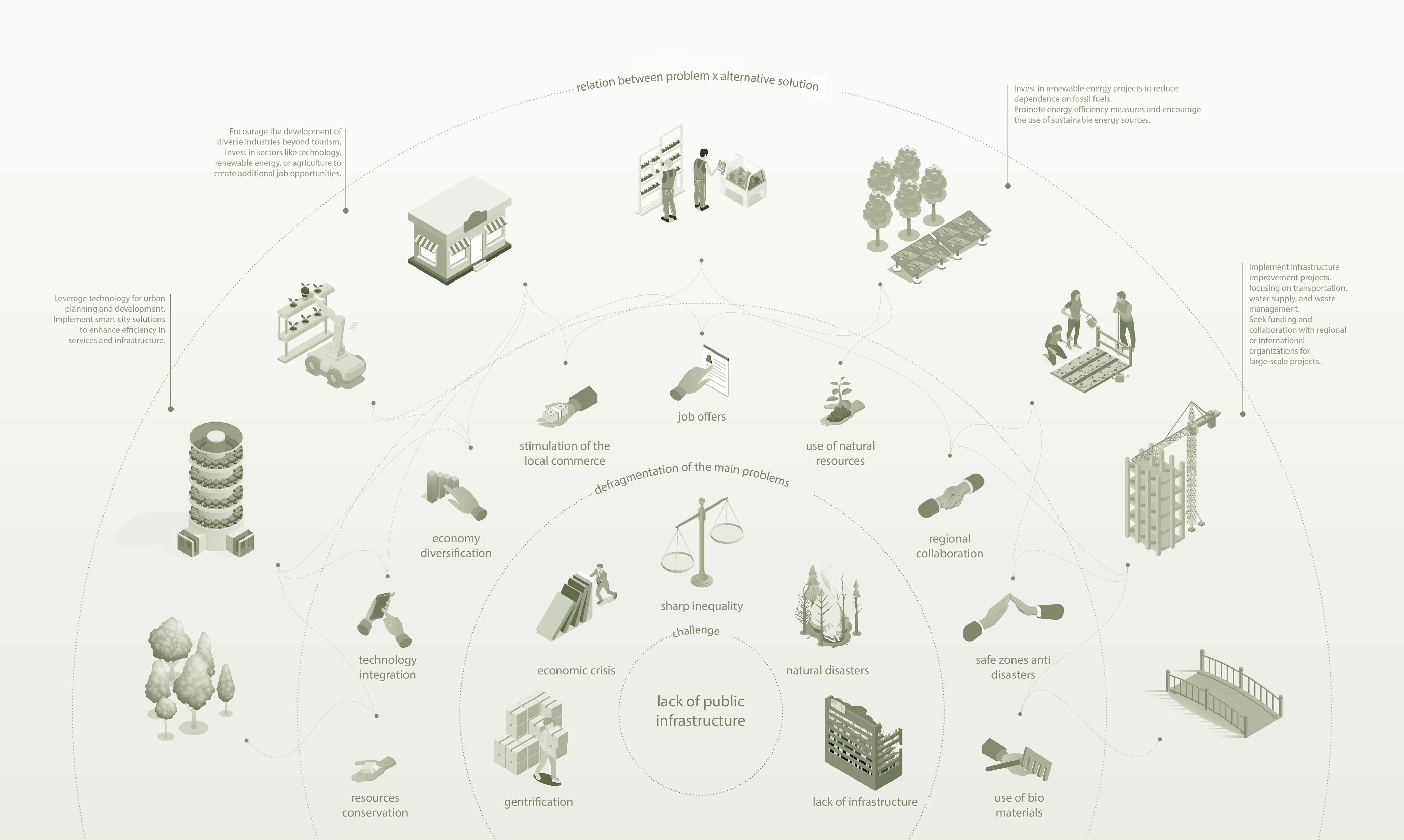
According to the European Observation Programme, La Palma has experienced both challenges and resilience in the face of natural events. Over the past years, the island has seen the emergence of 1,060 hectares of lava. This underscores the dynamic nature of the landscape, adding a layer of complexity to the task of managing tourism and sustainably. They also emphasize the balance required to maintain the island’s natural beauty, support its economy, and manage its growing.
The entire proposal explores urban planning and design strategies to achieve a sustainable and resilient future for La Palma, addressing key areas such as ecological conservation, infrastructure adaptation, social equity, and responsible tourism. Through careful research and collaboration with local communities, it is possible to create a harmonious coexistence between natural forces and human activities on this extraordinary island.
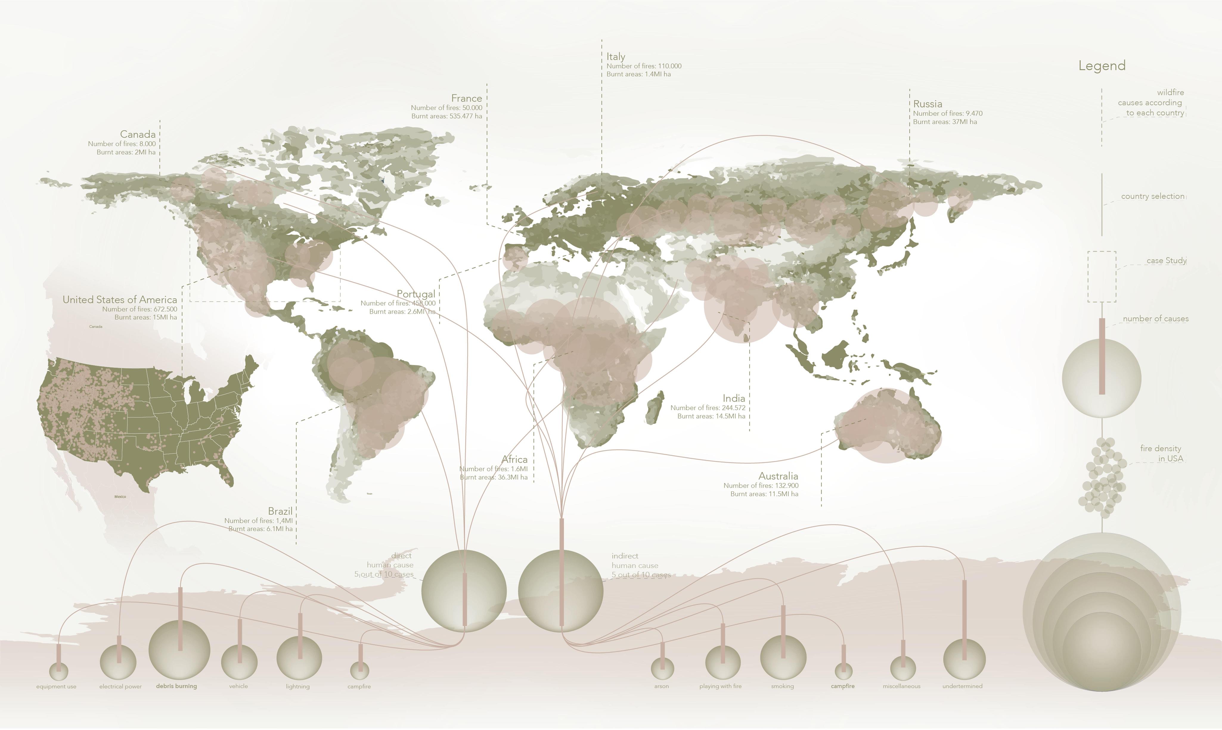
Worldwide Wildfires
Number of wildfires detected in the last decades
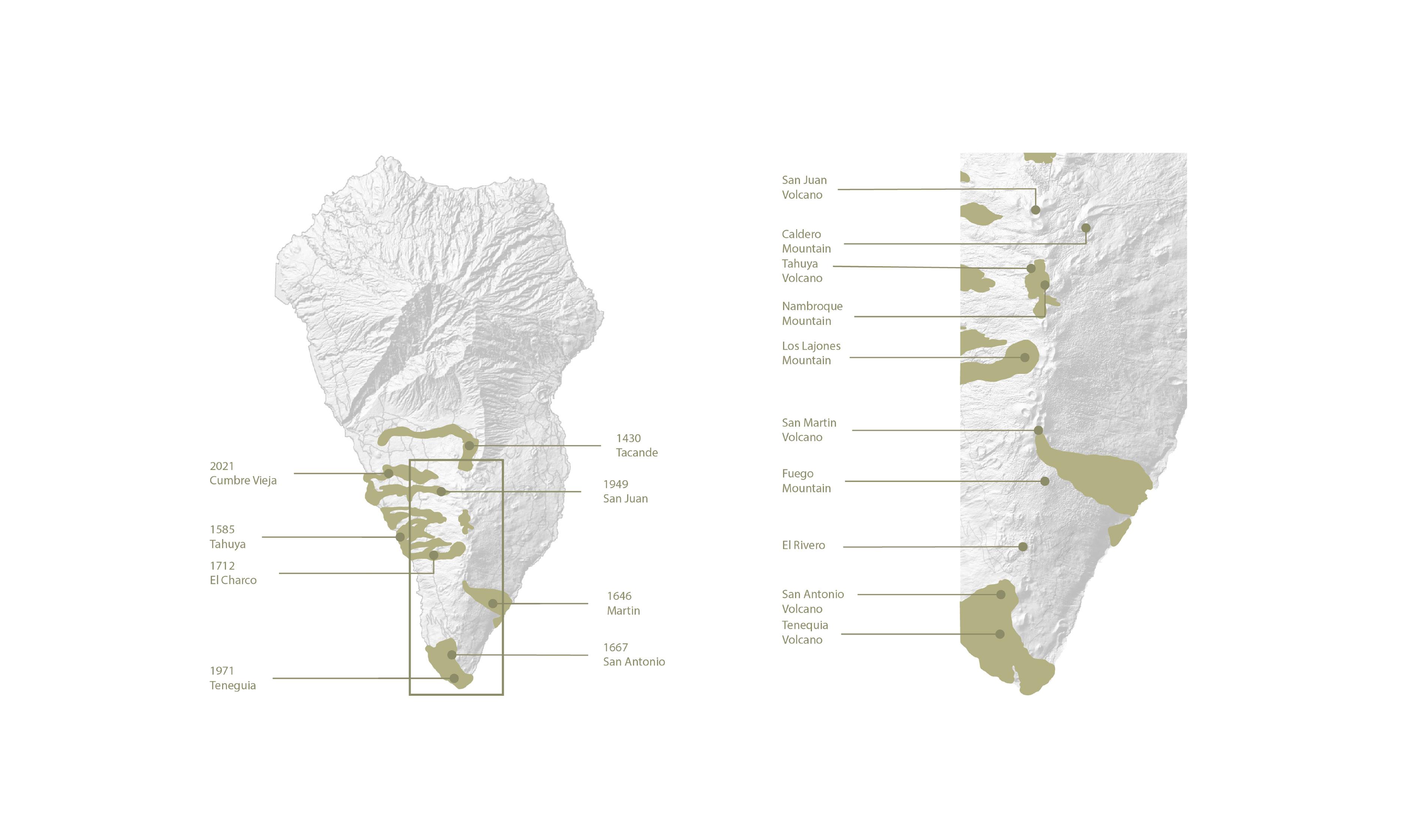
The volcanic mountain range extending south of La Palma is the youngest and most active area. The most-recent eruptions have occurred in this area.
Panorama of Volcanic Disasters in La Palma
Source: Roberto Rodríguez, editor of the geological guides to the National Parks of the Geological and Mining Institute of Spain, Copernicus satellite system, La Palma’s Cabildo Insular, the Geological and Mining Institute of Spain, Bing Maps, “Canaries: Intraplate Volcanic Islands” (Geo-Guías) and Science Direct (“The geology of La Palma”).
The Interplay of biodiversity and volcanic risks
Preserving Ecosystems Amidst Volcanic Peril
La Palma’s natural resources support its diverse fauna, but the island’s volcanic activity poses a constant threat which can devaste habitats, leading to loss of biodiversity. The interconnectedness of natural resources, fauna, and natural disasters becomes evident in the aftermath of such tragedies. The loss of biodiversity not only undermines ecosystem resilience but also affects the socio-economic fabric of the island, impacting industries like agriculture, tourism, and traditional practices reliant on the environment.
Ciclycal Metabolism
Rethinking the Island of La Palma
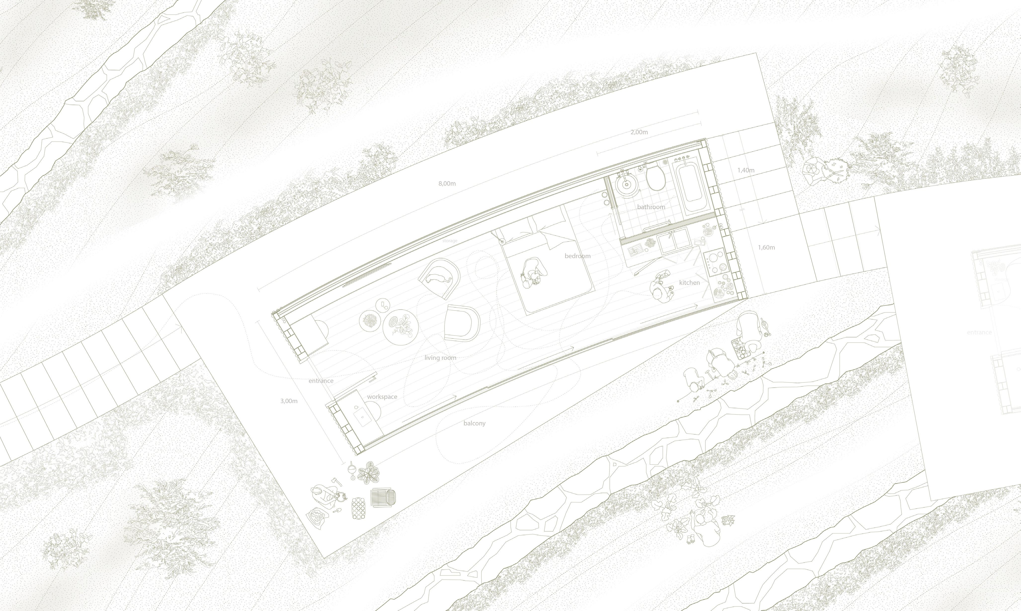
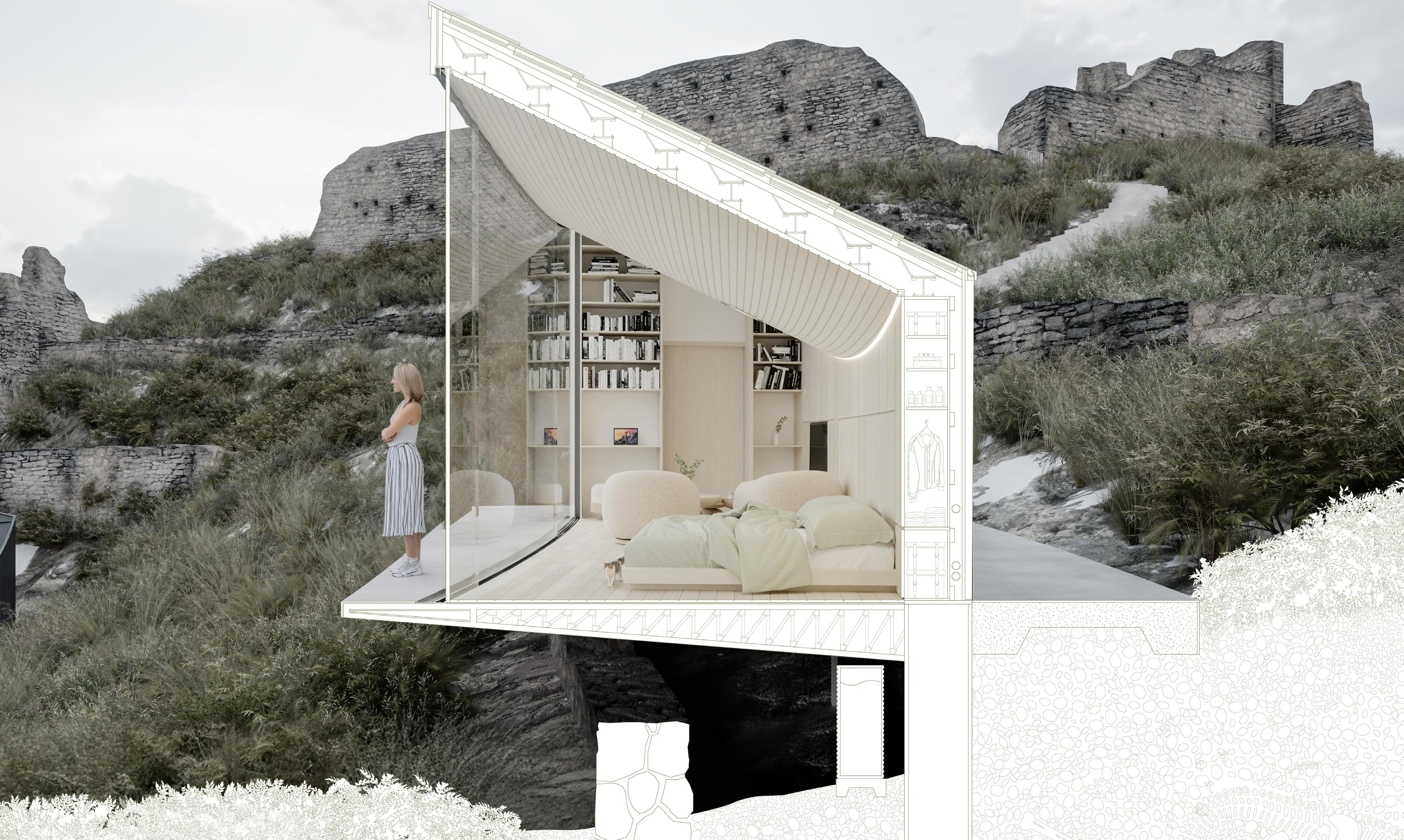
The Light Inside
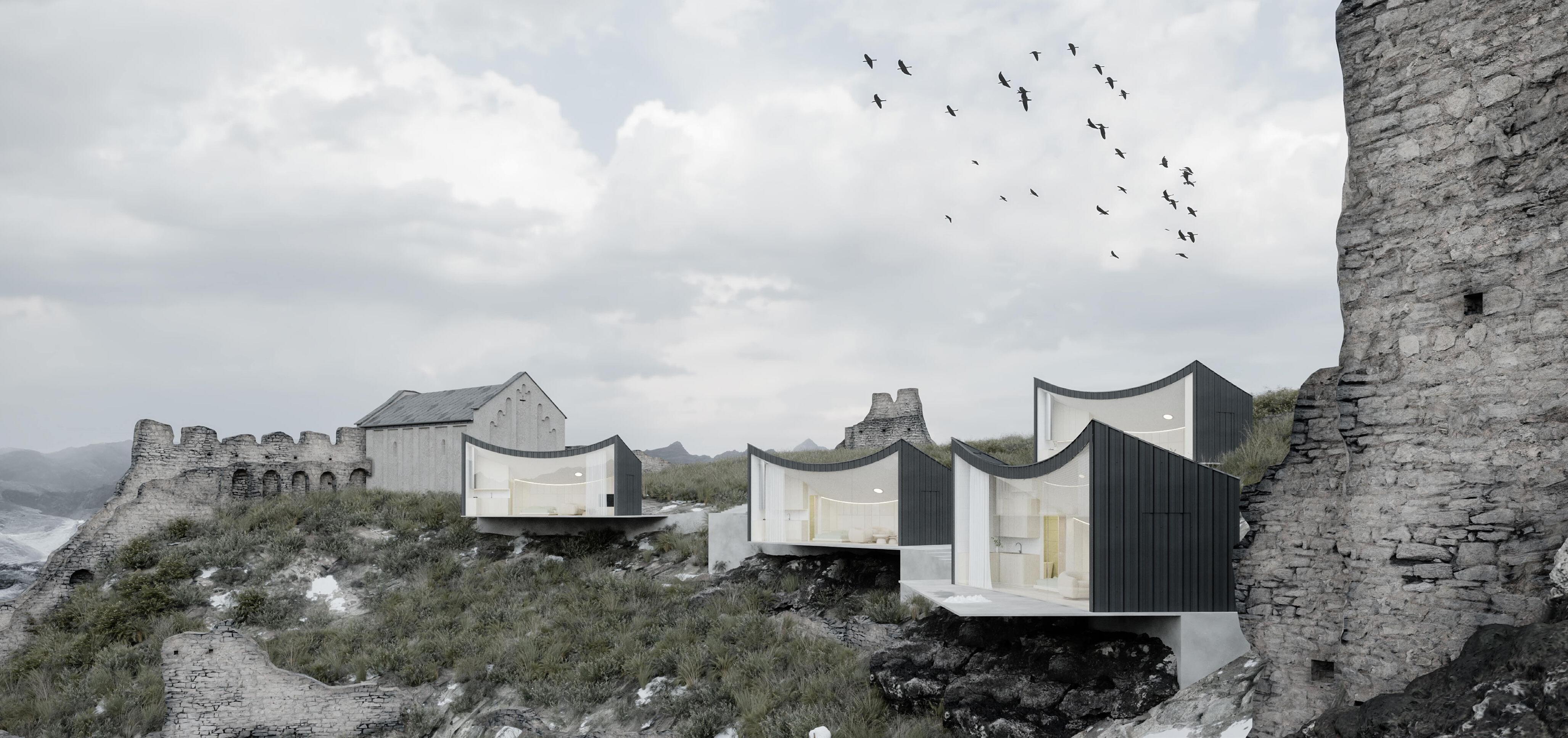
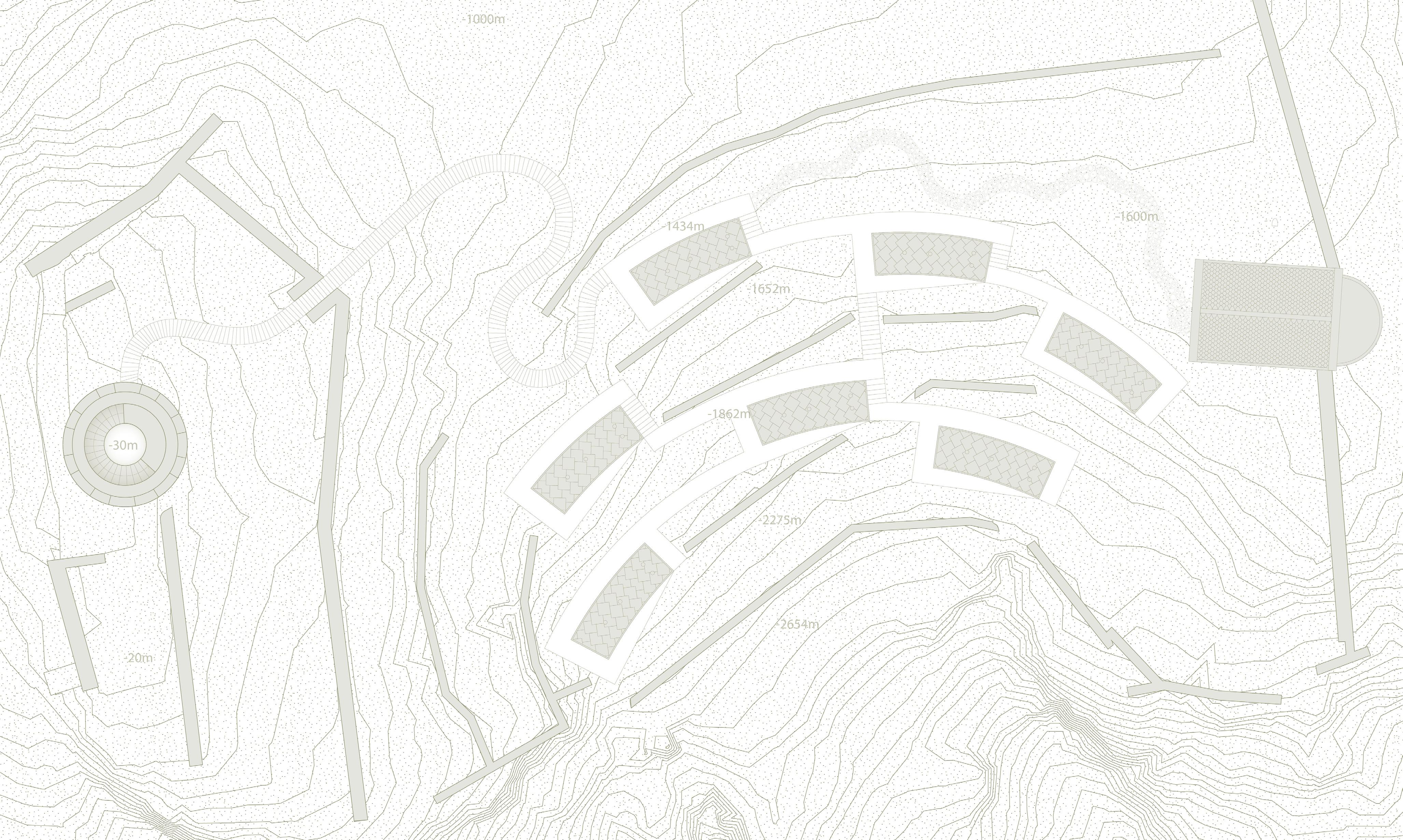
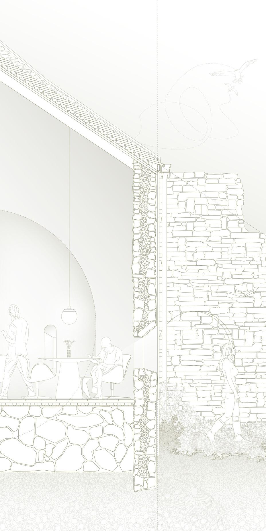
Reuse the Fortress Competition + Microhome Competition
Net-zero Cabins in the Aosta Valley, Italy. Solo Project.
Mentor: Ana Neiva, Professor at Porto School of Architecture.
Size: 258 SF.
Budget: 165,000 USD.
Introduction
Amidst the whispers of the Aosta Valley, a symphony of innovation and preservation unfolds. Every inch of space has been meticulously designed to maximize utility and comfort. The space creates a sanctuary that harmonizes with the environment while offering comfort.
The lightning within is powered by the sun, illuminating the space with a warm, eco-friendly glow. Rich wood and an elegant travertine adorn the interior space, infusing the microhome with a sense of natural luxury, offering respite and harmony amidst the Alpine landscape. A parabolic catenary roof stretches slightly above, shaping both interior and exterior. In this marriege of form and function the cabins becomes an extention of the land.
Large windows frame breathtaking views of the mountains, inviting the beauty of the outdoors inside. As the seasons change, the space adapts, providing warmth in the winter and coolness in the summer through innovative insulation. Futhermore, the exterior scene seamlessly integrates with the natural surroundings, using sustainable materials that mirror the colors, movements and textures of the landscape that surrounds the whole site project.
The microhome’s interior layout prioritizes spatial efficiency without sacrificing quality of life. A multi-functional living area integrates seamlessly with a compact yet fully equipped kitchen, while the sleeping quarters utilize retractable furniture to expand usable space. Smart home technology further enhances convenience, with energy monitoring and efficiency systems and adaptive climate control ensuring optimal performance during all of the seasons of the year.
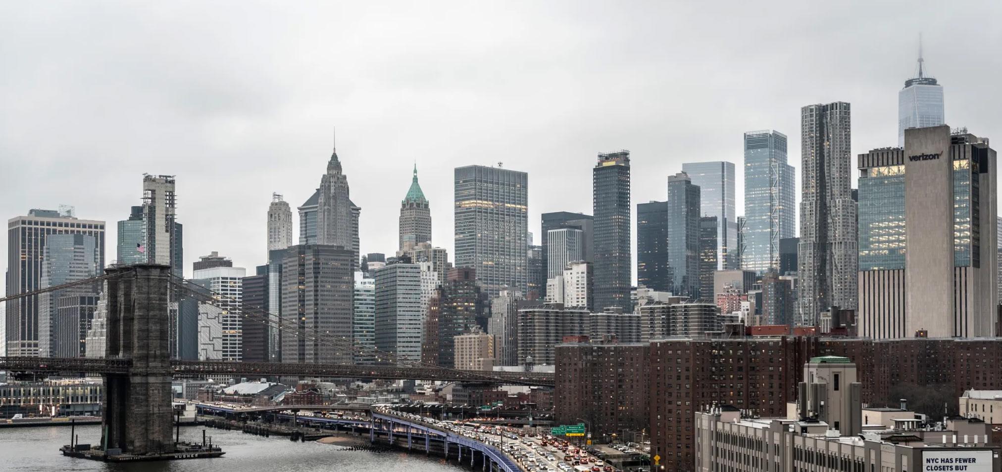
Urban Web: Reconnecting FDR Drive with New York’s Communities
Columbia Graduate School of Architecture, Planning, and Preservation, Columbia Climate School and Columbia Law School
Mentors and Professors: Michelle Young (Professor, Graduate School of Architecture, Planning, and Preservation), Sheila Foster (Columbia Law School), Laura Popa (Professor, Sustainability Management School) and Alex de Sherbinin (Director, Climate School). Solo Project.
Size: 154,000 SF.
Budget: 6,7 BI USD.
Design Proposal
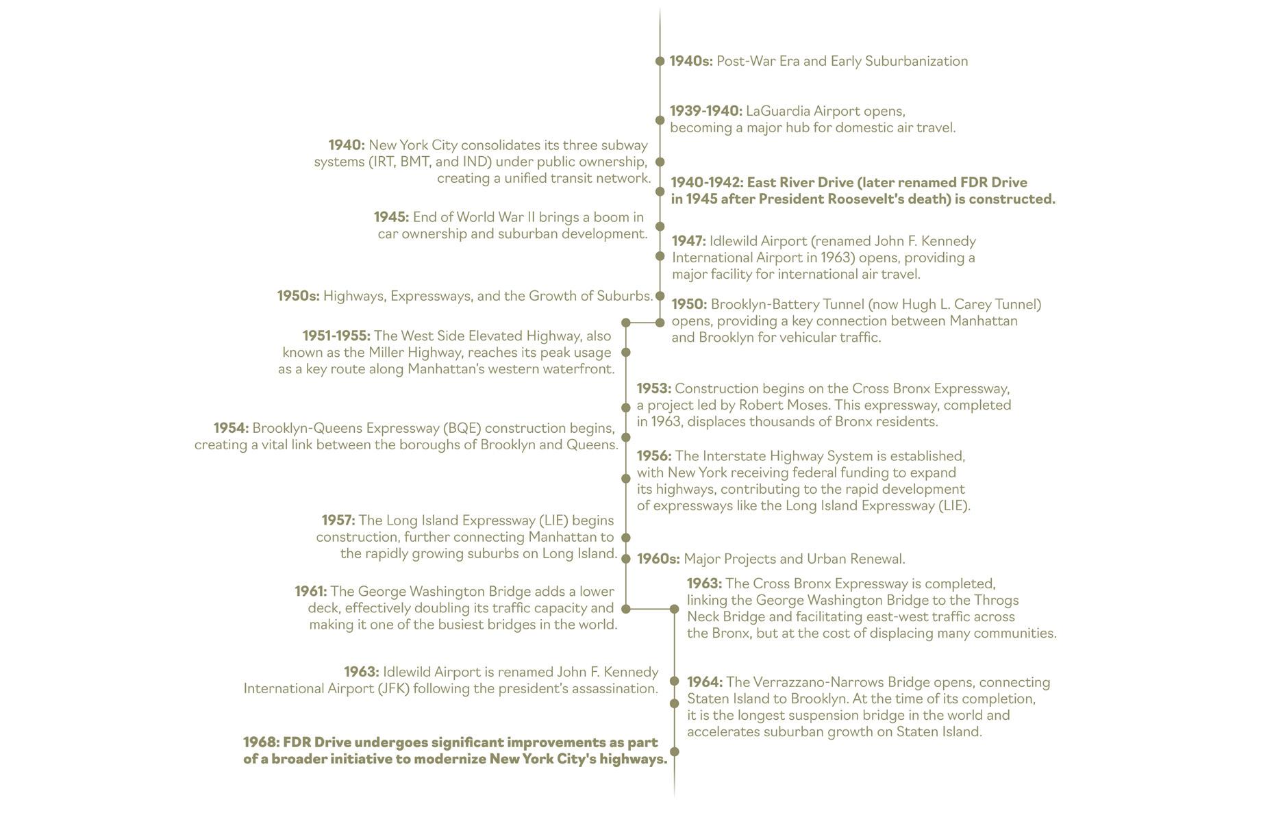
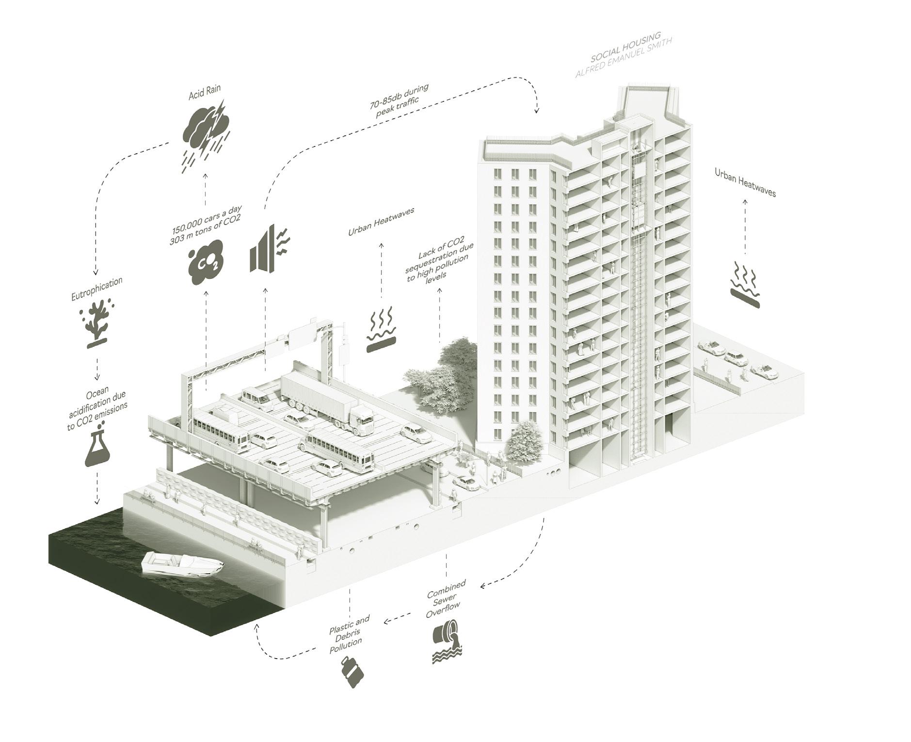
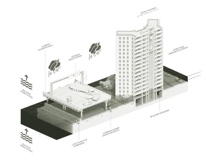
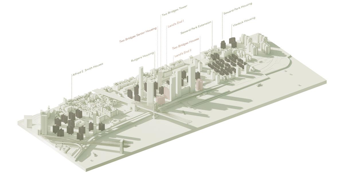
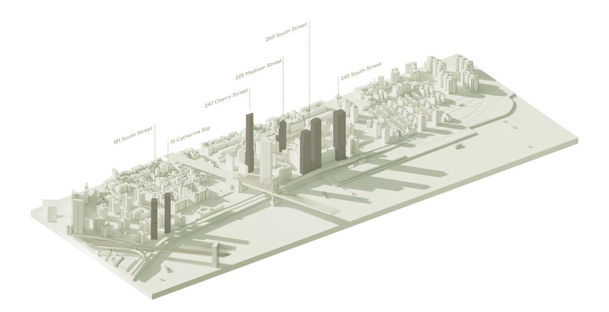
The Franklin D. Roosevelt East River Drive serves as a pivotal transit artery in New York, yet its current design and infrastructure present profound challenges. Originally conceived in the 1930s and completed by the early 1940s, this critical highway is burdened by a history of car-centric urban planning. Today, it exemplifies pressing social, and climate vulnerabilities that necessitate urgent attention.
This memorandum explores the profound impacts of FDR Drive on health, equity, and climate resilience. Adjacent communities, predominantly low-income, face heightened exposure to air pollution and the urban heat island effect, contributing to alarming disparities in respiratory and heat-related illnesses. The roadway itself, spanning over 9.5 miles along Manhattan’s eastern edge, is increasingly threatened by extreme weather events, sea-level rise, and infrastructure aging.
Hurricane Sandy’s devastation underscored the region’s susceptibility, resulting in $19 billion in damages citywide and exposing glaring infrastructural deficiencies.
Proposed interventions prioritize equity, sustainability, and resilience, aligning with both the CLCPA and federal funding opportunities under initiatives such as the Infrastructure Investment and Jobs Act (IIJA). Key recommendations include the transformation of select lanes into green, walkable pathways, enhanced public transit via Bus Rapid Transit (BRT), the incorporation of congestion pricing mechanisms, and retrofitting social housing to withstand climate impacts. Integrating green infrastructure, such as bioswales and tree canopies, not only mitigates air pollution and urban heat but also improves community well-being.
Furthermore, this redesign of the road envisions a cohesive, community-driven approach to urban planning. By creating accessible parks and recreational areas, increasing transit accessibility, and establishing flood-resistant housing solutions, this policy fosters inclusivity and resilience. Emphasis is placed on integrating Leadership and Environmental and Energy Design certification in housing projects and relocating critical infrastructure in flood-prone areas. These measures safeguard residents, reduce economic disparities, and address the dual imperatives of sustainability and social equity.
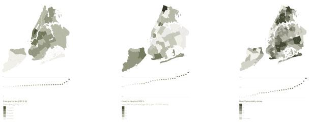
Air Pollution in New York City 2014 to 2024
FDR Drive Timeline 1940 to 1968
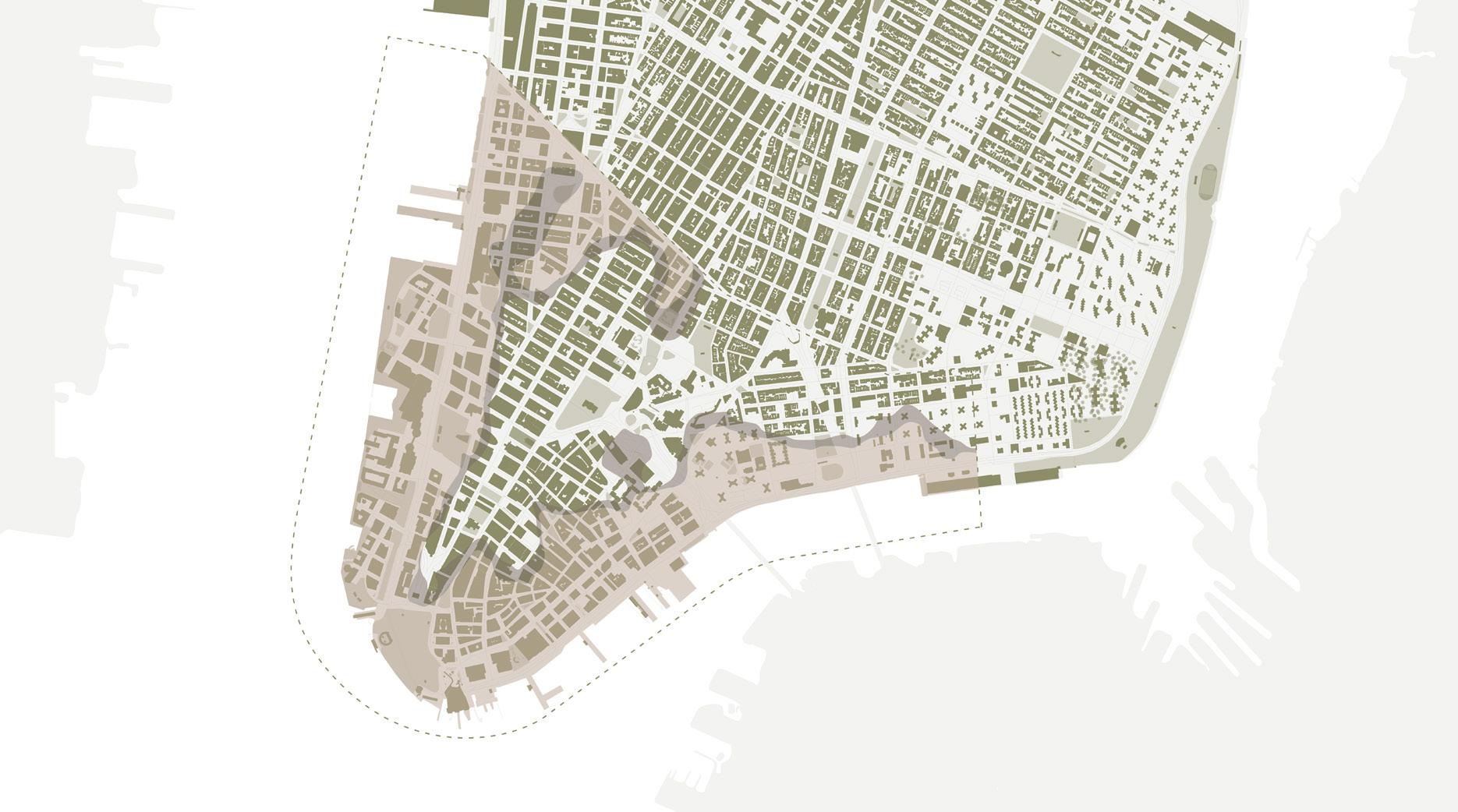
Flooding Area
Flooding in downtown area in the next 50 and 100 years
Statement of Issue
Health Costs: Communities adjacent to the FDR Drive experience 30% higher asthma rates due to vehicle emissions (According to New York City Department of Health, in 2021), contributing to New York City’s $3.3 billion annual burden from pollution-related illnesses (American Public Health Association, 2018). Health disparities are further exacerbated by urban heat islands, which increase the risk of heat-related illnesses by 20% in affected areas (According to New York City Department of Environmental Protection, in 2019). Residents in these areas face heightened risks of heat-related illnesses, worsened by limited access to green spaces and cooling infrastructure, underscoring the urgent need for equitable, climate-resilient interventions.Additionally, while the city has committed to addressing urban heat islands through various planning frameworks (such as PlaNYC), the lack of substantial investments in green infrastructure in these areas has left large portions of the city — particularly low-income communities near the FDR Drive — without access to cooling and green accessible spaces. These gaps in policy implementation and infrastructure exacerbate existing health disparities, illustrating how current urban planning and policy frameworks have failed to adequately address or mitigate the compounded risks faced by these communities.
Economic Inequities and Lack of Inclusive Planning: Low-income communities near major infrastructure, such as the FDR Drive, bear the brunt of environmental injustices. The lack of green accessible infrastructure and tree canopy coverage worsens air pollution and limits cooling during heatwaves, leading to a 20% higher risk of heat-related illnesses (According to New York City Department of Environmental Protection, in 2019). Despite climate adaptation policies like PlaNYC, implementation often overlooks these vulnerable neighborhoods, leaving them exposed to compounding health and environmental risks.
Economic inequities in urban development arise from uneven resource allocation and exclusionary planning practices. For instance, only 40% of residents in areas like the Lower East Side have access to parks within a 10-min. walk, compared to 75% in affluent communities (According to Regional Plan Association, in 2020).
Climate Vulnerability and Infrastructure Deficiencies: New York City’s climate plans, like the Lower Manhattan Coastal Resiliency (LMCR) project, focus on flood barriers but neglect critical infrastructure such as the FDR Drive. Low-lying areas, especially those housing marginalized communities, lack adequate climate resilience. Aging NYCHA buildings are excluded from retrofitting plans, increasing displacement risks. The FDR Drive and Lower East Side face threats from sea level rise and extreme weather. By 2050, flooding could disrupt infrastructure for 165,000 residents (NYC Department of City Planning, 2020). Heatwaves further elevate health risks and cooling costs. During Hurricane Sandy in 2012, over 60 NYCHA buildings flooded, displacing 17,000 residents and causing $1 billion in damages (NYCHA, 2013; FEMA, 2013). By 2050, 10,000 housing units in the Lower East Side risk annual flooding, with damages projected at $4 billion (NYC DEP, 2019). These risks disproportionately impact low-income households, amplifying economic and social vulnerabilities.
“The noise is constant here, day and night - it’s always like that. I’ve lived here for over 26 years, and it feels like it’s only gotten worse. The construction never seems to end, and I honestly don’t even know what they’re building anymore.” - Local worker.
Isometric Diagram Environmental Damage Diagram - 100 years
Isometric Diagram Environmental Damage Diagram - 50 years
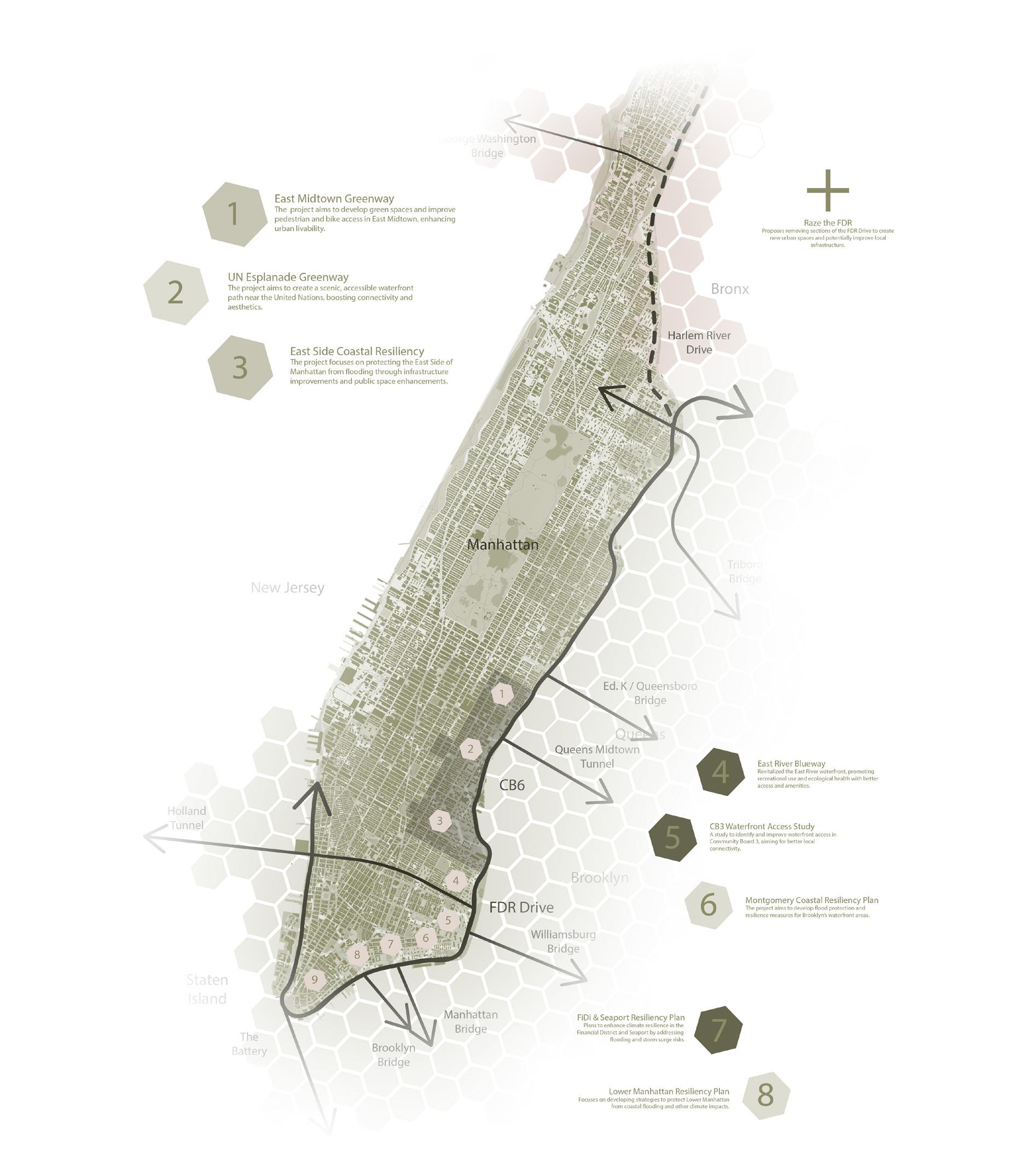
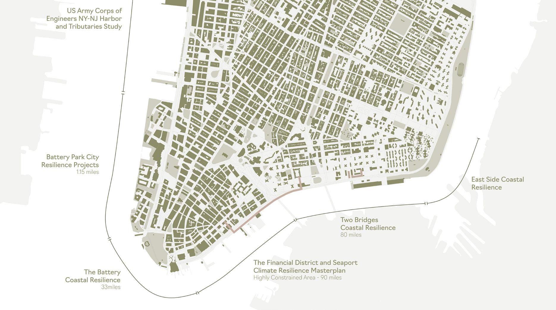
Current Proposals
Downtown and Midtown Current Plans
Suggested Policies
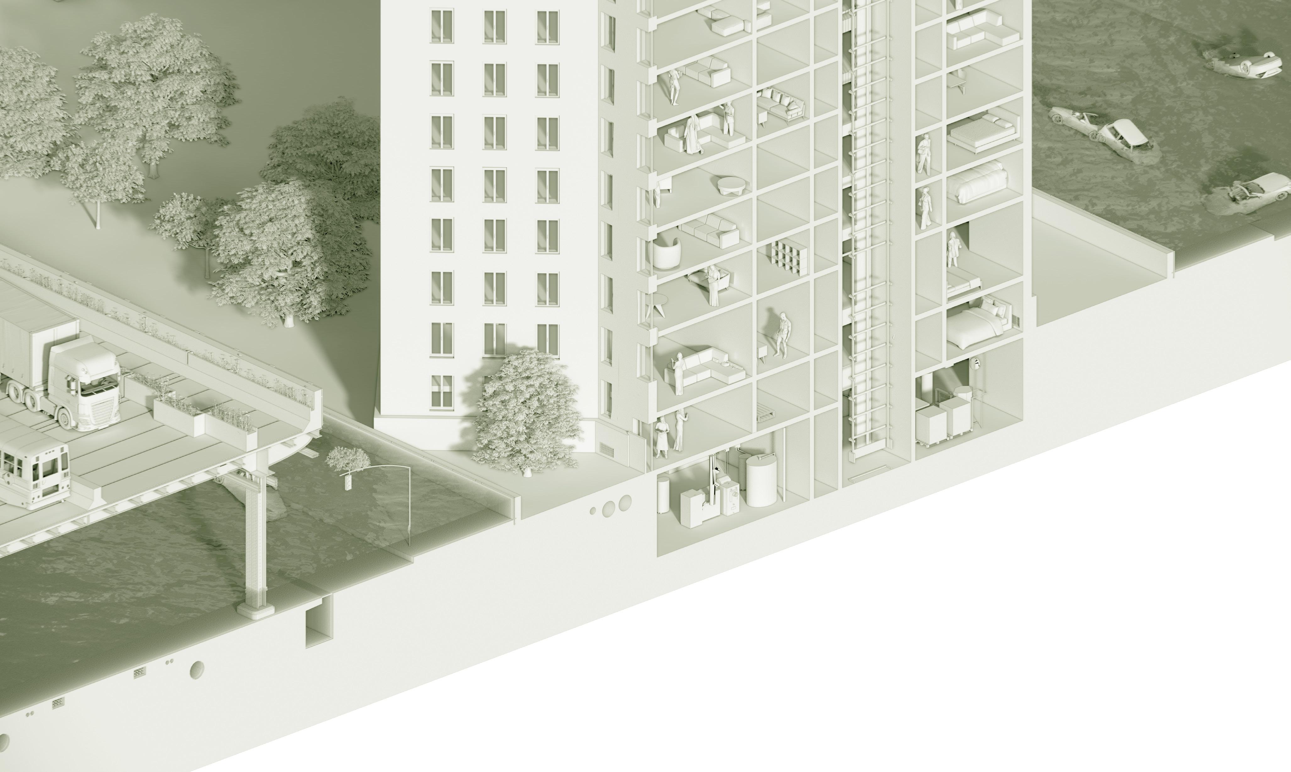
The integration of green infrastructure and walkable pathways is a fundamental component of this redesign. By converting two of the six lanes on the FDR Drive into pedestrian-friendly spaces during non-peak hours, the area will become more accessible to the community. These pathways will feature trees and bioswales to reduce heat, noise, and air pollution, creating a healthier environment for the local population. Particular attention will be given to underserved areas, such as the Lower East Side, where public housing residents currently lack sufficient access to green recreational spaces. This transformation is anticipated to improve community well-being and reduce the urban heat island effect.
In addition to enhancing walkability, the proposed strategy emphasizes climate-resilient retrofits for the roadway. This includes the installation of permeable pavements and modular flood barriers, which will safeguard the infrastructure against rising sea levels and extreme weather events. Cooling technologies, such as reflective materials, will also be implemented to mitigate heat-related risks. These retrofits will ensure the long-term functionality of the FDR Drive while protecting the vulnerable populations who rely on it.
To reduce emissions and promote sustainable transit options, the introduction of Bus Rapid Transit (BRT) systems and car-free zones is also proposed. Dedicated BRT lanes will be established, facilitating efficient, electric bus routes that connect key areas along the drive. During non-peak hours, certain segments will be converted into pedestrian zones, allowing for community engagement and recreation. These measures aim to decrease reliance on private vehicles, lower traffic congestion, and provide equitable transit access for underserved communities.
Another significant policy change involves the extension of congestion pricing to the FDR Drive This measure will discourage unnecessary car trips and
generate revenue for further public transit improvements. To ensure fairness, exemptions and tiered discounts will be provided for electric vehicles and low-income residents. Revenue from this policy will support the expansion of BRT and other sustainable mobility initiatives.
Lastly, the redesign includes the implementation of climate-resilient and sustainable social housing for communities near the Drive. Public housing developments will be upgraded to incorporate flood-resistant materials, elevated infrastructure, and energy-efficient cooling systems. New housing projects in the area will be required to achieve the Leadership in Environmental and Energy Design certification ensuring that they meet both resilience and sustainability standards. These enhancements aim to protect low-income communities from climate-related displacement while promoting equity and environmental stewardship.
In conclusion, the proposed transformation of the drive addresses critical environmental, social, and climate challenges while promoting equity and resilience. By integrating green infrastructure, enhancing public transit, and retrofitting vulnerable infrastructure, New York can set a precedent for sustainable urban development. These investments will not only improve the quality of life for residents but also position the city as a leader in climate adaptation and sustainability
Target Groups
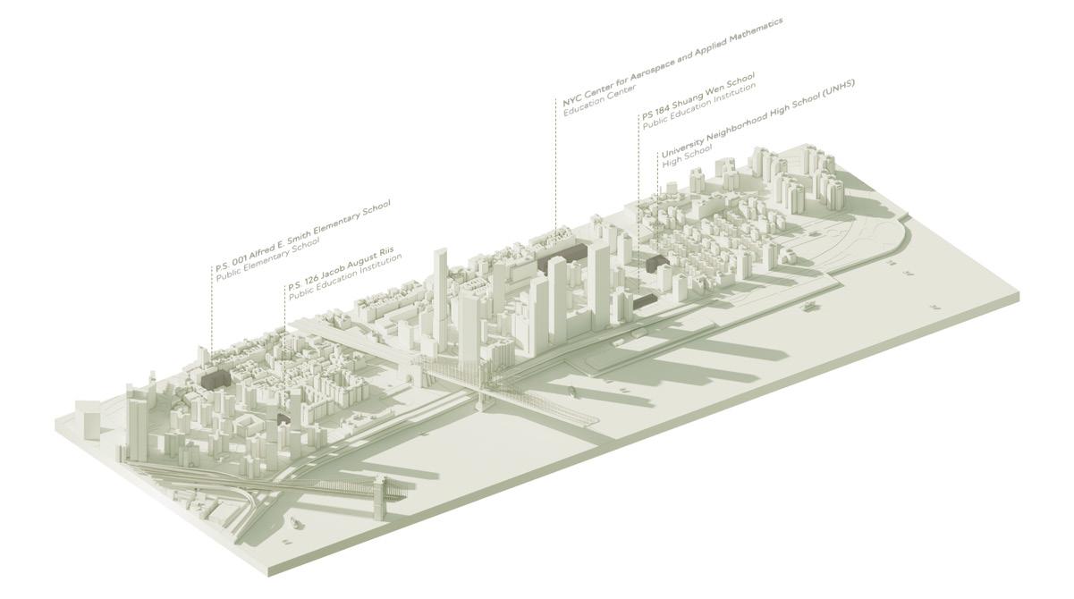
Educational Buildings
NYCHA Housing X Private Social Housing
New Developments < 2028
Dry flood protection barrier
Flood Vents: Openings that allow floodwater to flow in and out, reducing pressure on walls.
Raising HVAC Units: Installing units on higher floors or elevated platforms.
Wet flood protection gates
Hinged Flood Barriers: Gates that can be swung into place before a flood.
Dry flood protection barrier
Flood Vents: Openings that allow floodwater to flow in and out, reducing pressure on walls.
Upgrade NYCHA housing near FDR Drive with flood-resistant materials, relocating mechanical, electrical, and plumbing systems above the flood levels to comply with FEMA and NYC Flood Resilience standards.
Wet flood protection involves measures to prevent water from entering a structure or area during floods. It creates barriers or seals to keep interior dry, commonly used for critical infrastructure and flood-prone properties
Isometric Diagram
Enviromental Resiliency: Dry Floodproofing
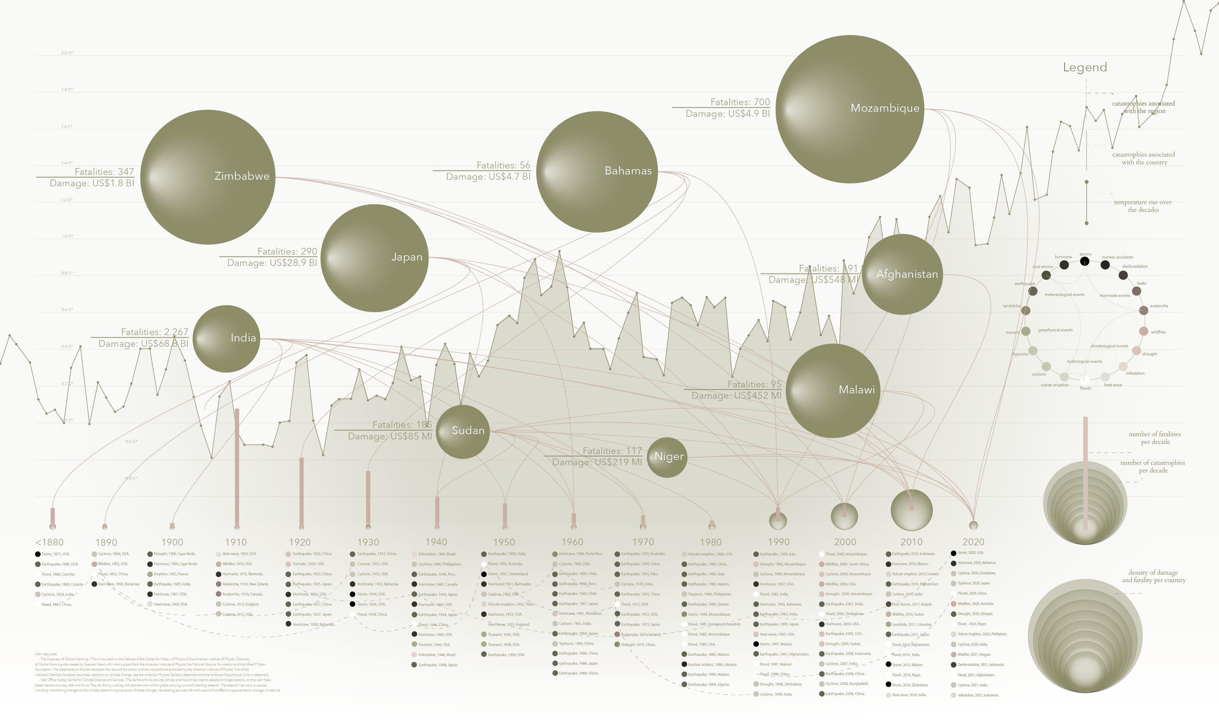
Climate Change Panorama
Environmental Catastrophes from 1880 to 2020
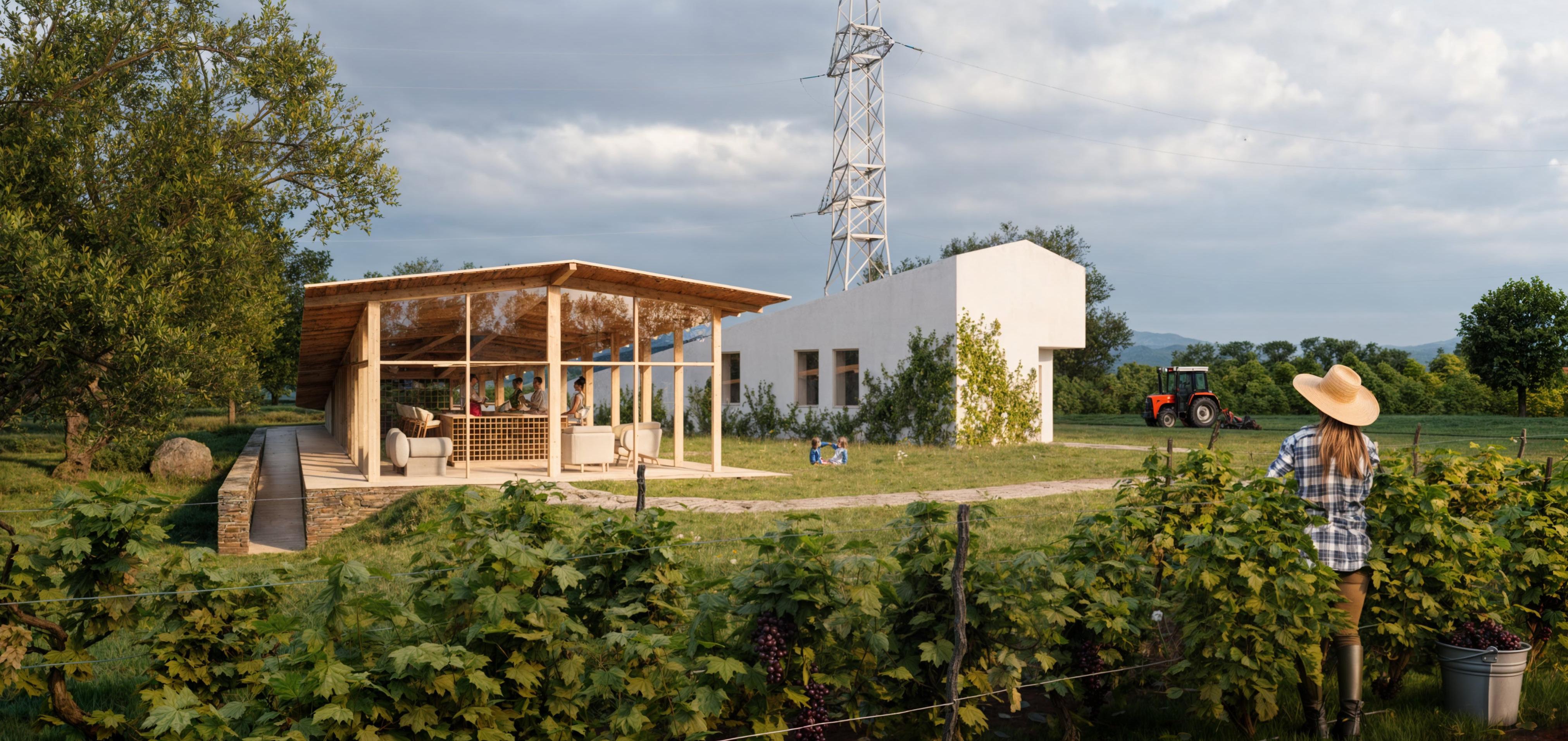
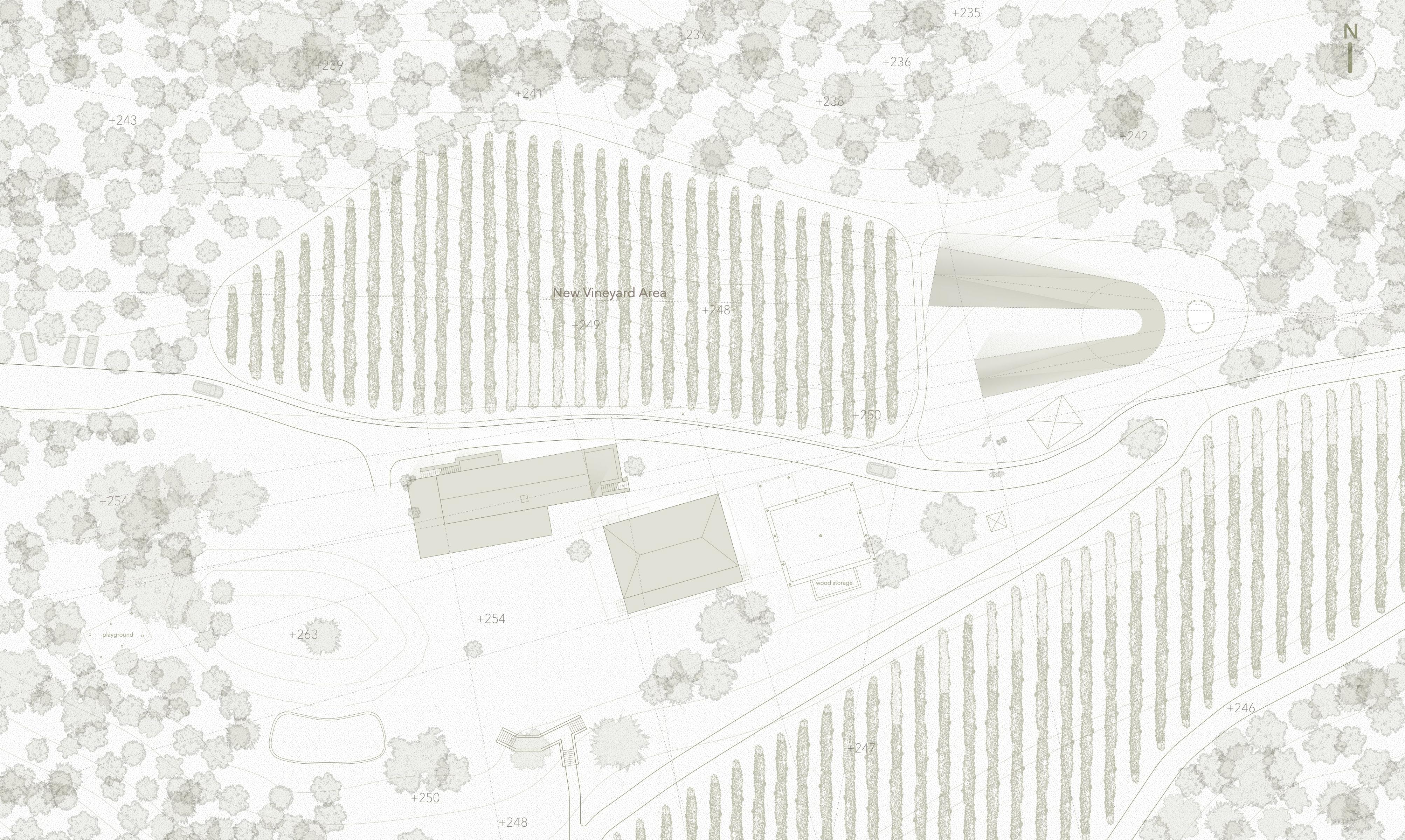
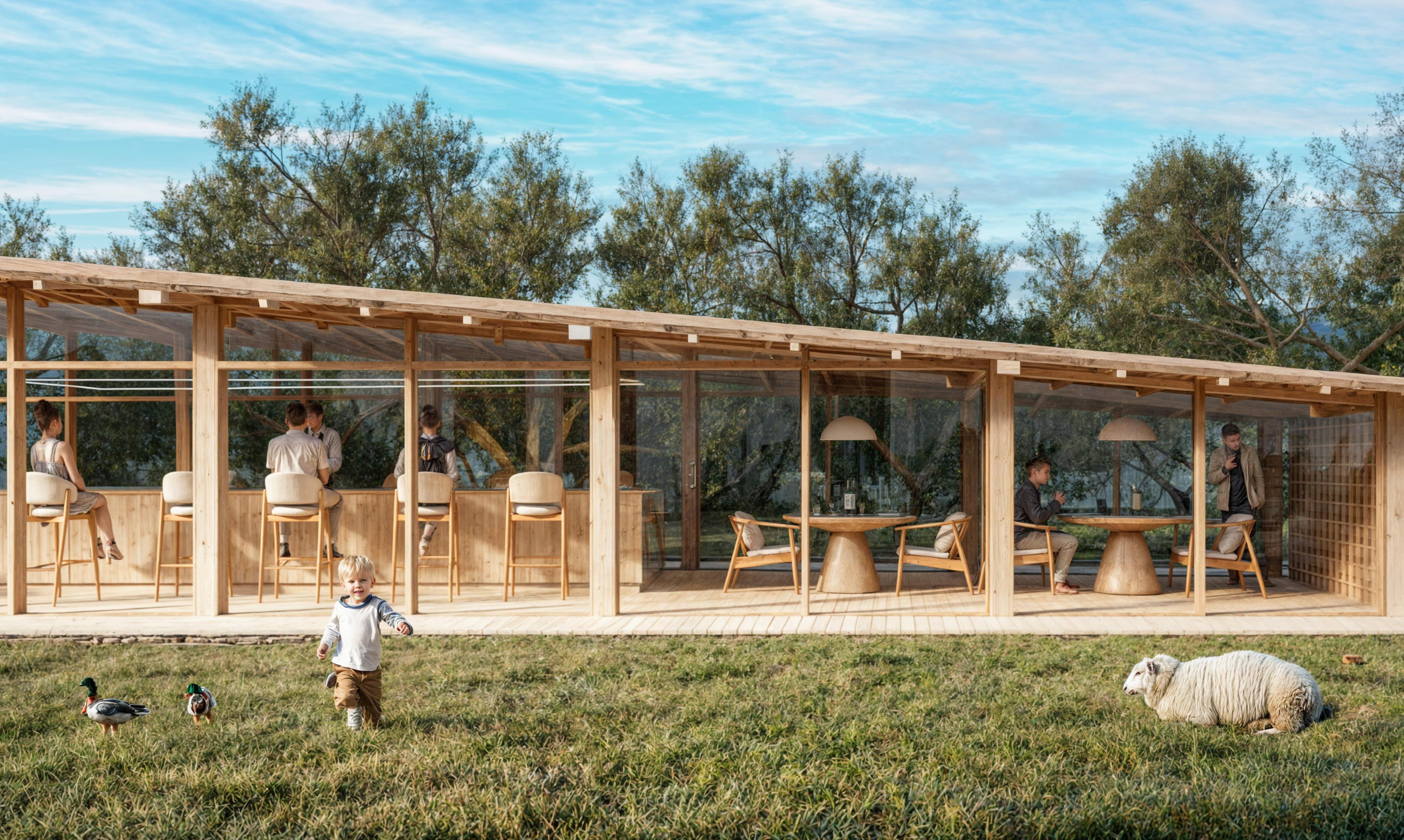
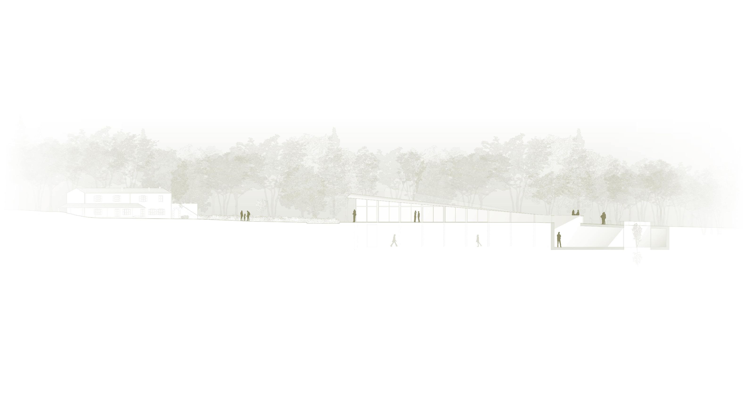
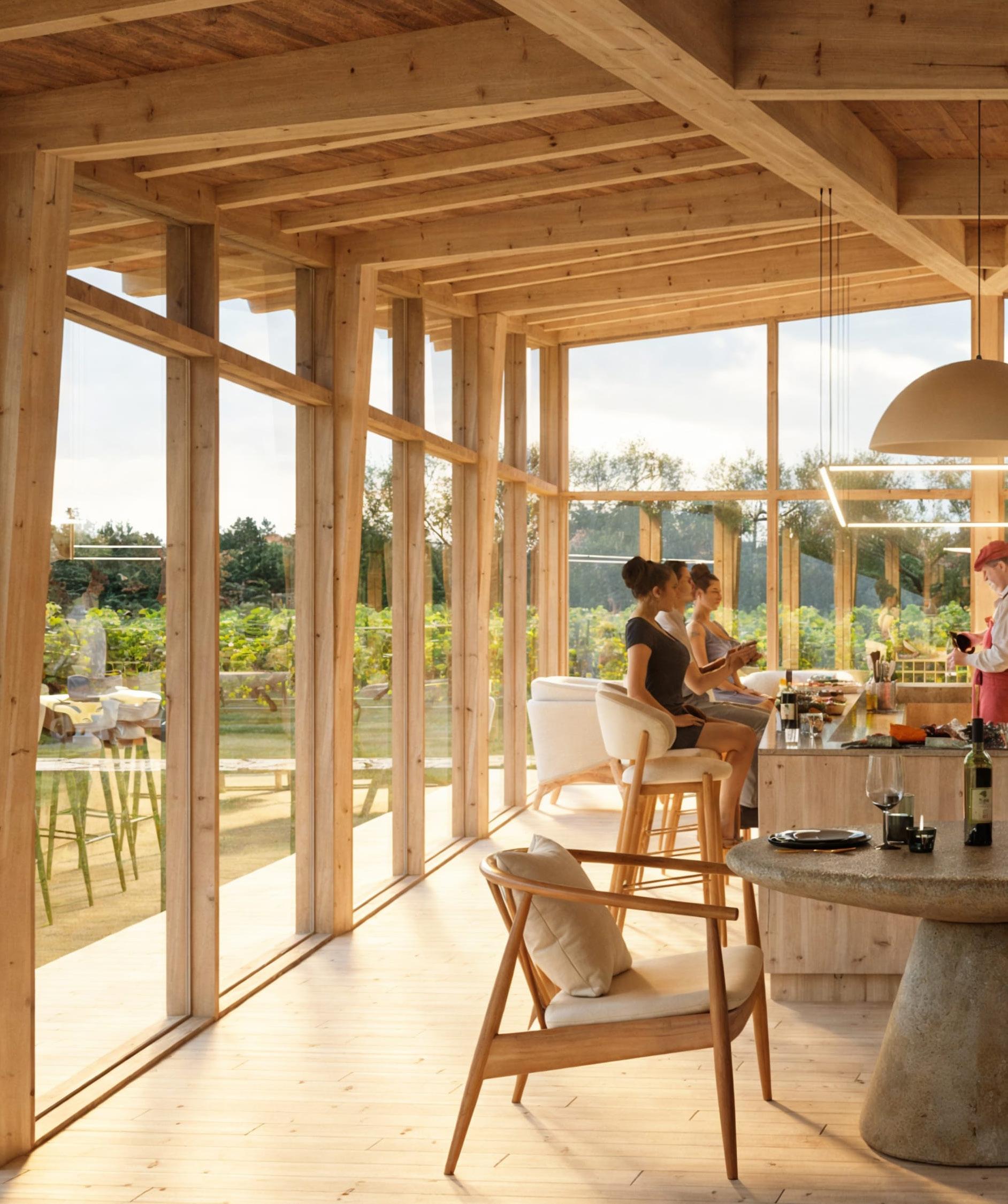
Cultural Winnery
Terraviva Cultural Winnery Competition
Mixed-use building in Tuscany, Italy. Solo Project.
Mentors: Ana Neiva, Porto School of Architecture. Portugal.
Design Proposal
In the heart of Tuscany, rises a building that breathes the essence of wine culture as a living testimony to the harmony between nature and human creation. By embracing the newly planted vineyard, the building becomes an integral part of the landscape, a natural extension of the environment.
Furthermore, Its U-shaped form is an invitation to encounter, a gesture of hospitality that invites visitors to enter its amenetie’s spaces, where the scent of mass timber structure and the soft echo of steel blend in a unique architecture.
To its left stands the wooden building welcomes high italian gastronomy lovers with an open kitchen island while the cellards the deepest secrets of wine, patiently waiting to be discovered.
On the other side, like a silent guardian, rises the steel frame structure, an enigmatic fortress that houses the backstage of the building. Between these two opposites, a central courtyard emerges as an oasis of tranquility, a meeting point where opposites meet and merge in perfect harmony.
Here, under the gaze of the vineyards, visitors and staff come together around a common passion: wine, celebrating the art and poetry of life.
Size: 22,300 SF
Budget: 880,000 USD.
At the heart of it all lies a central courtyard, a tranquil oasis where contrasts meet and converge in perfect harmony. This open space, under the watchful gaze of the vineyards, becomes a gathering place where visitors share a common passion: the celebration of wine. In this space, the art of winemaking transcends its craft, becoming a magic symbol of life’s poetry, a toast to tradition, and a bridge between the past and future..
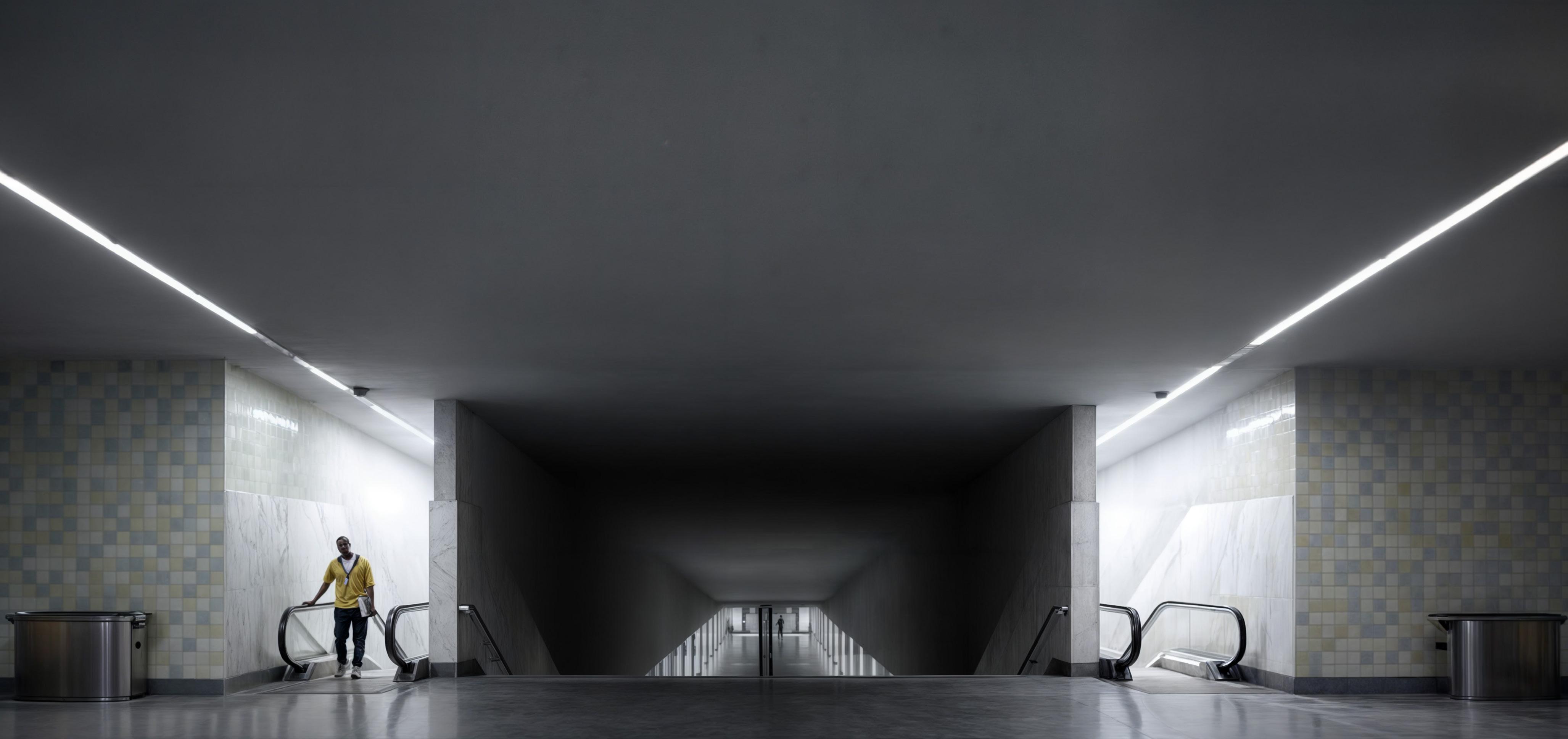
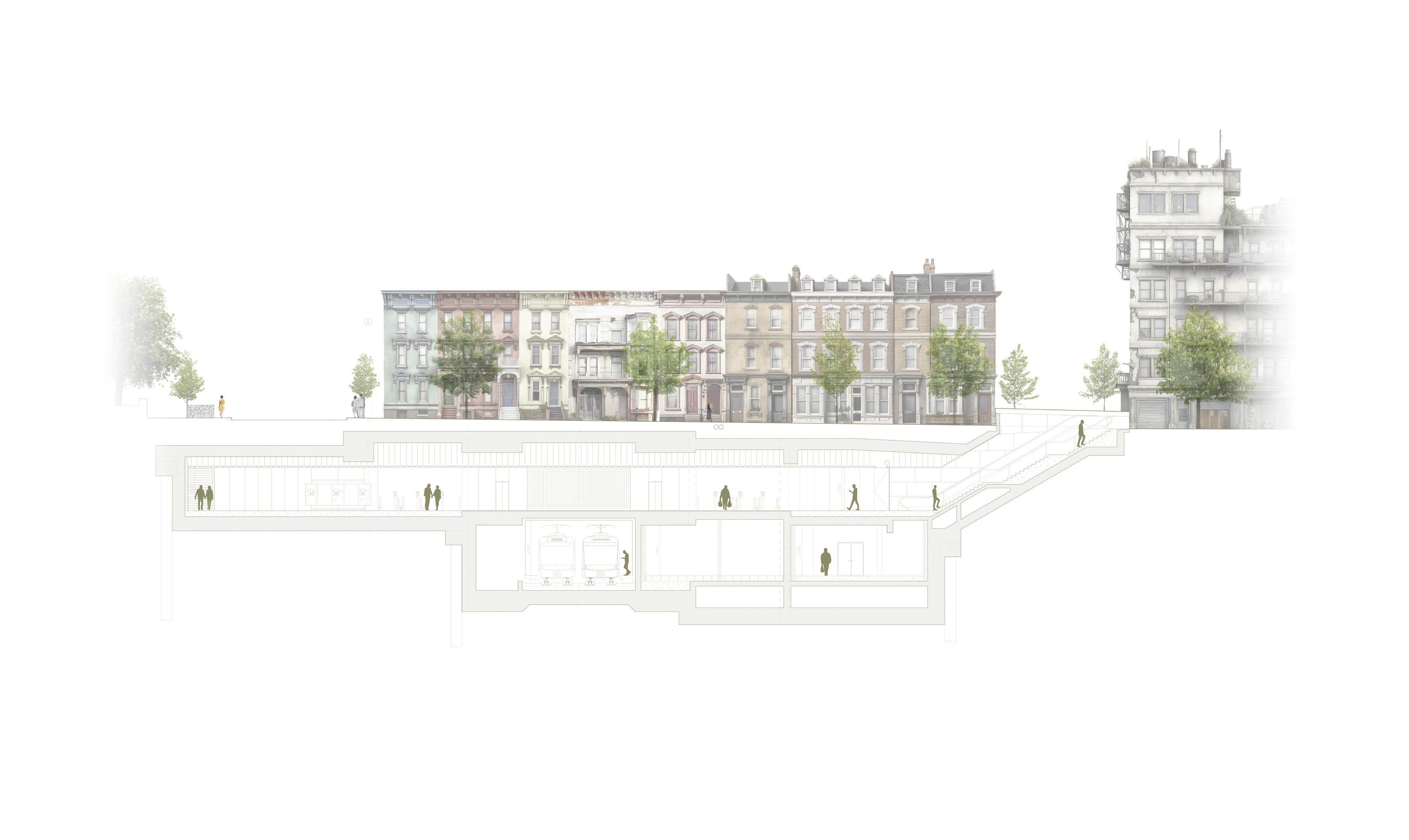
Public Infrastructure
Alvaro Siza Architects + Souto de Moura Architects.
Large scale infrastructure project in Porto, Portugal. Group Project.
Team: Soraia Pereira (Project Leader, Building Information Modeling), Gilberto Alvarenga (Structural Engineer, Building Information Modeling), and Sonia Camilletti (Structural Engineer, Building Information Modeling).
Size: 2,370,000 SF.
Budget: 520 MI USD.
Design Proposal
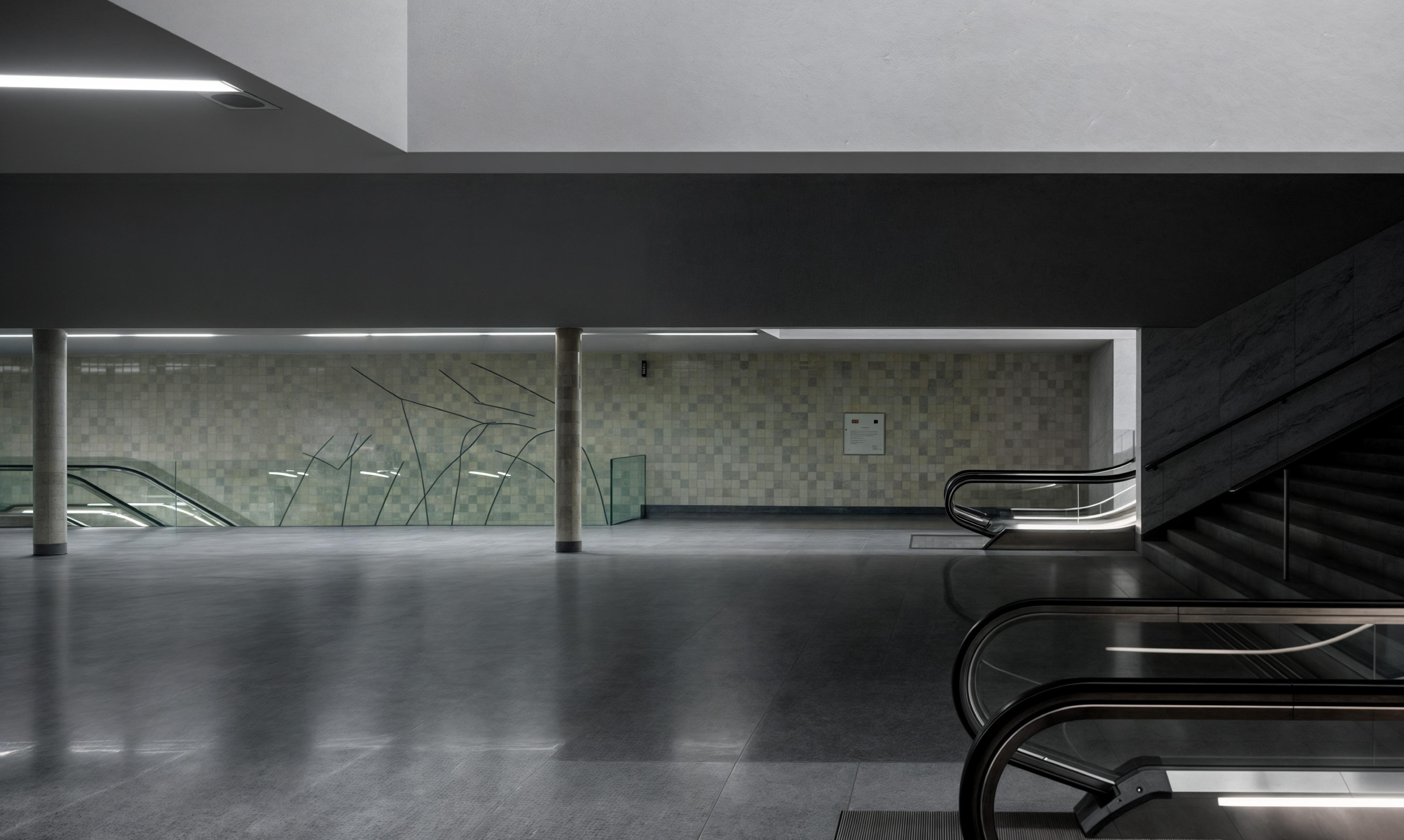
Utilizing BIM, I played a crucial role in translating the design concepts into detailed and functional digital models, ensuring precision in the construction process. BIM not only facilitated the visualization of the architects’ ideas but also allowed for the efficient coordination of design aspects.
The digital representation of the stations through BIM served as a valuable tool in optimizing both the aesthetic and functional aspects of the metro spaces.This collaborative effort underscores the commitment to innovation.The integration of sustainable practices, energy efficiency, and seamless connectivity, as realized through BIM modeling, further emphasizes the forward-thinking approach adopted in the development of these architectural and urban design landmarks.
BIM not only enabled a clear visualization of the architects’ ideas but also streamlined the coordination of diverse design elements. These included structural components, energy systems, and sustainable design features. The digital representation of the metro stations through BIM proved invaluable in optimizing both aesthetic and functional aspects, serving as a collaborative platform for architects, engineers, and other stakeholders.
Furthermore, the metro stations were conceived with a user-centric approach, emphasizing smooth transitions between different transportation modes. This design encourages the adoption of sustainable travel alternatives, such as cycling and public transport, thereby promoting a greener urban lifestyle. The stations not only function as transit hubs but also as architectural landmarks, contributing to the city’s identity while advancing its sustainability agenda.
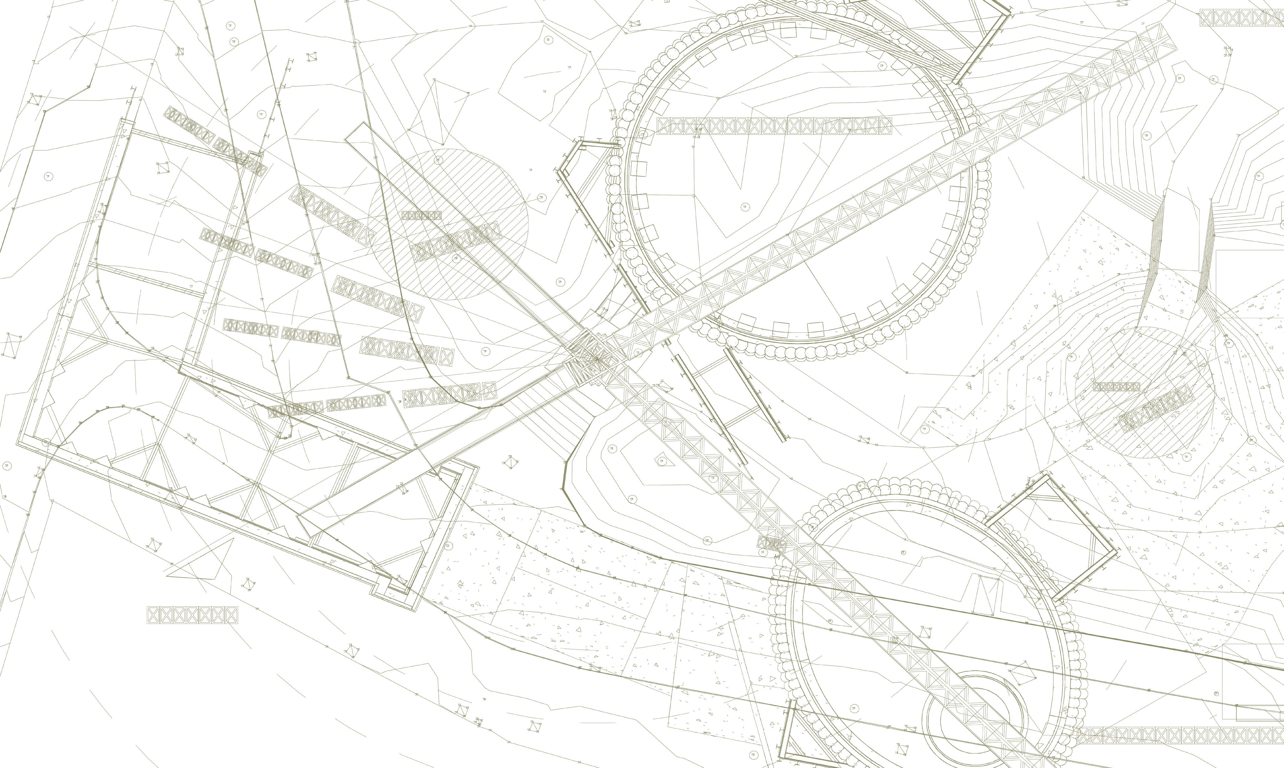
Galiza Station Longitudinal Section + Street Facade
Scale: 1/100
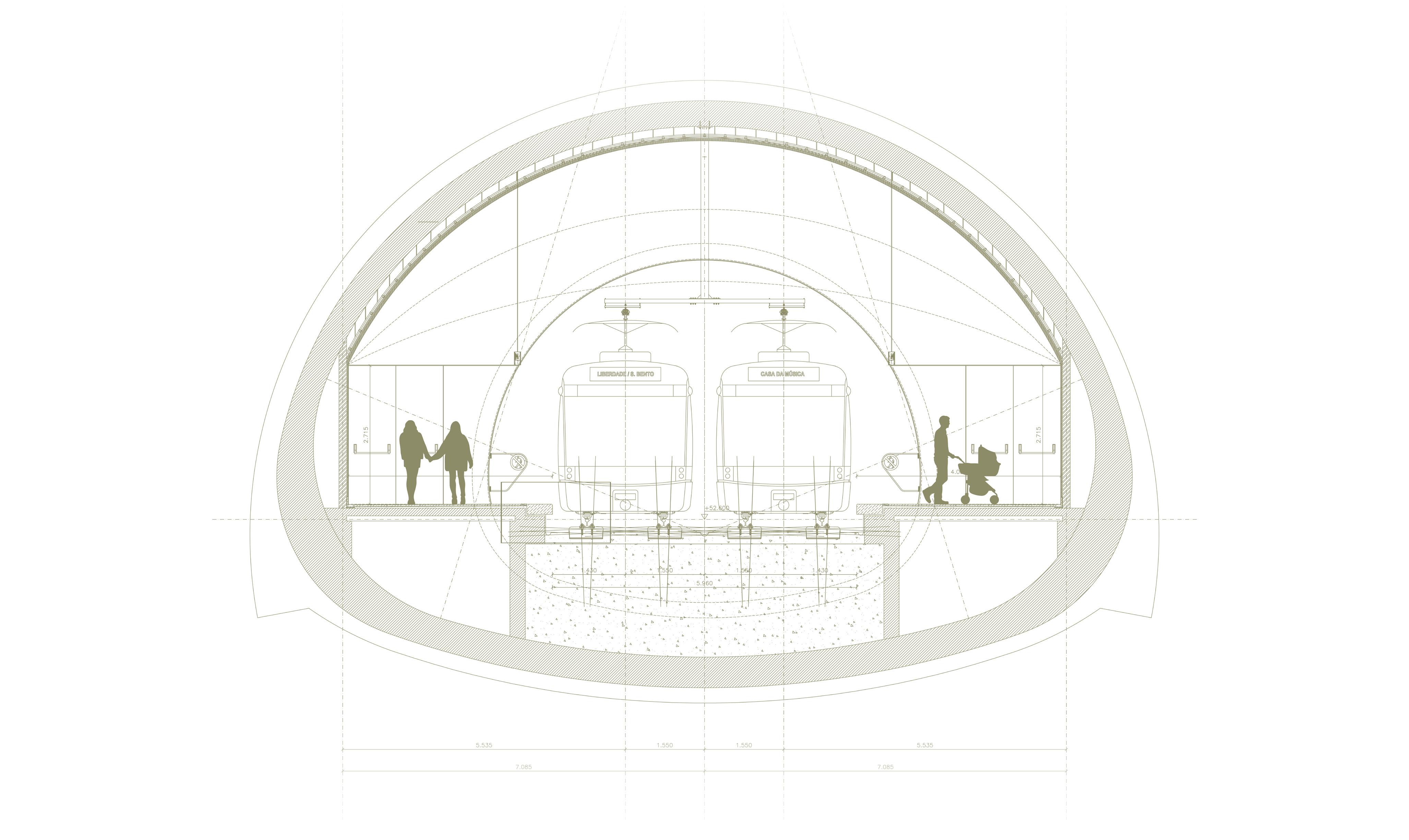
Liberdade Station Detailed Transversal Section AA
Scale: 1/50
Conceptual Tree Interference Plan +12.1m
Scale: 1/300
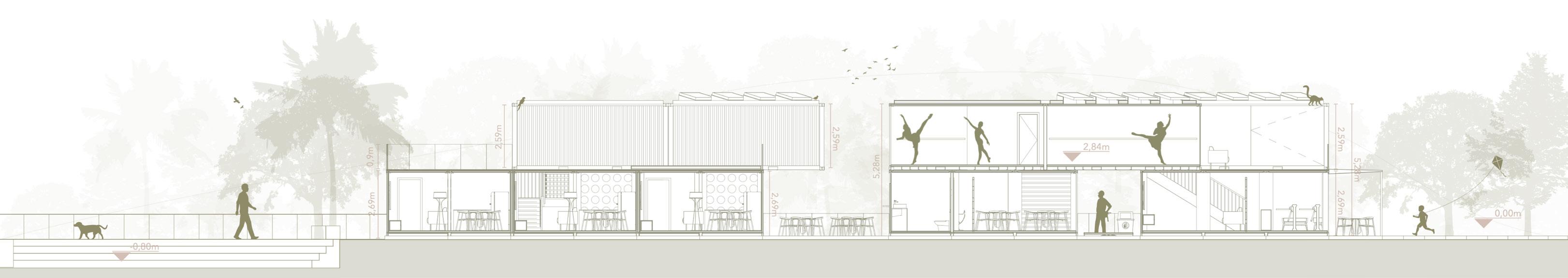
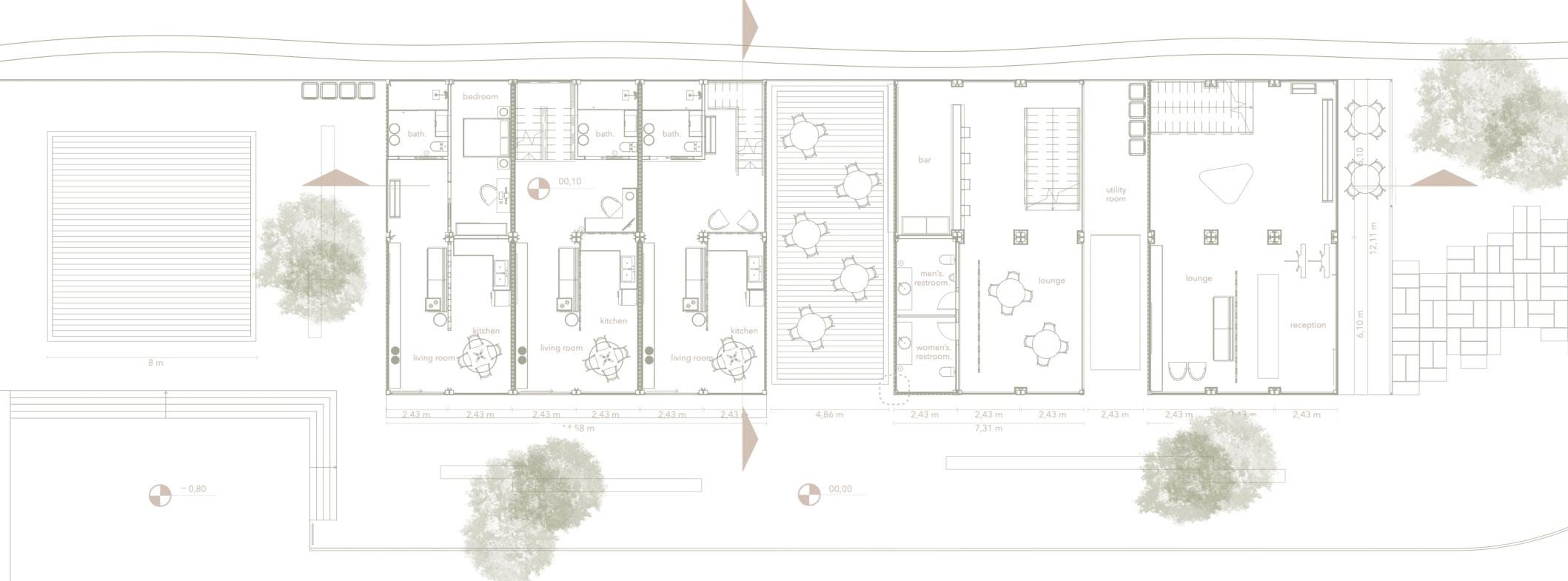
Out of Sight + Columbia Climate School
Sustainable dance school and emergency social housing in Rio de Janeiro, Brazil. Solo Project.
Mentors and Professors: Mariela Salgado, President (Brazilian Institute of Architecture), Alex de Sherbinin (Director, Columbia Climate School), Johanna Lovecchio (Professor, Columbia Climate School).
Size: 4,520 SF.
Budget: 168,000 USD.
Design Proposal
Throughout the development of my project, my objective is to cater to the specific needs of local residents, with a keen awareness of the bucolic environment and the lack of essential public services. I am committed to ensuring basic amenities not only for the residents of Frades Island but also for Maré,
As I conceptualized the project, I was acutely conscious of the persistent removal of “irregular houses” dating back to the 19th century. This displacement, stemming from the unsuccessful attempt at “hygienization” in Rio de Janeiro. The design prioritizes the importance of an accessible construction, utilizing easily obtainable materials that seamlessly blend with the site. The design of the project emphasizes accessibility, afordability, and ecological sensitivity.
The conceptualization of this project was guided by a deep understanding of the persistent displacement of communities and the removal of so-called “irregular houses,” a practice that dates back to the 19th century in Rio de Janeiro.
This displacement was driven by the misguided and ultimately unsuccessful attempts at “hygienization,” which prioritized urban aesthetics over the well-being and stability of marginalized communities.
.By employing readily available and locally sourced materials, the construction achieves seamless integration with the surrounding environment. This approach ensures not only the preservation of the site’s historical and cultural significance but also promotes sustainability and adaptability to future challenges. The integration of these elements reflects my commitment to honoring the unique characteristics of the site while addressing the urgent needs of the community.
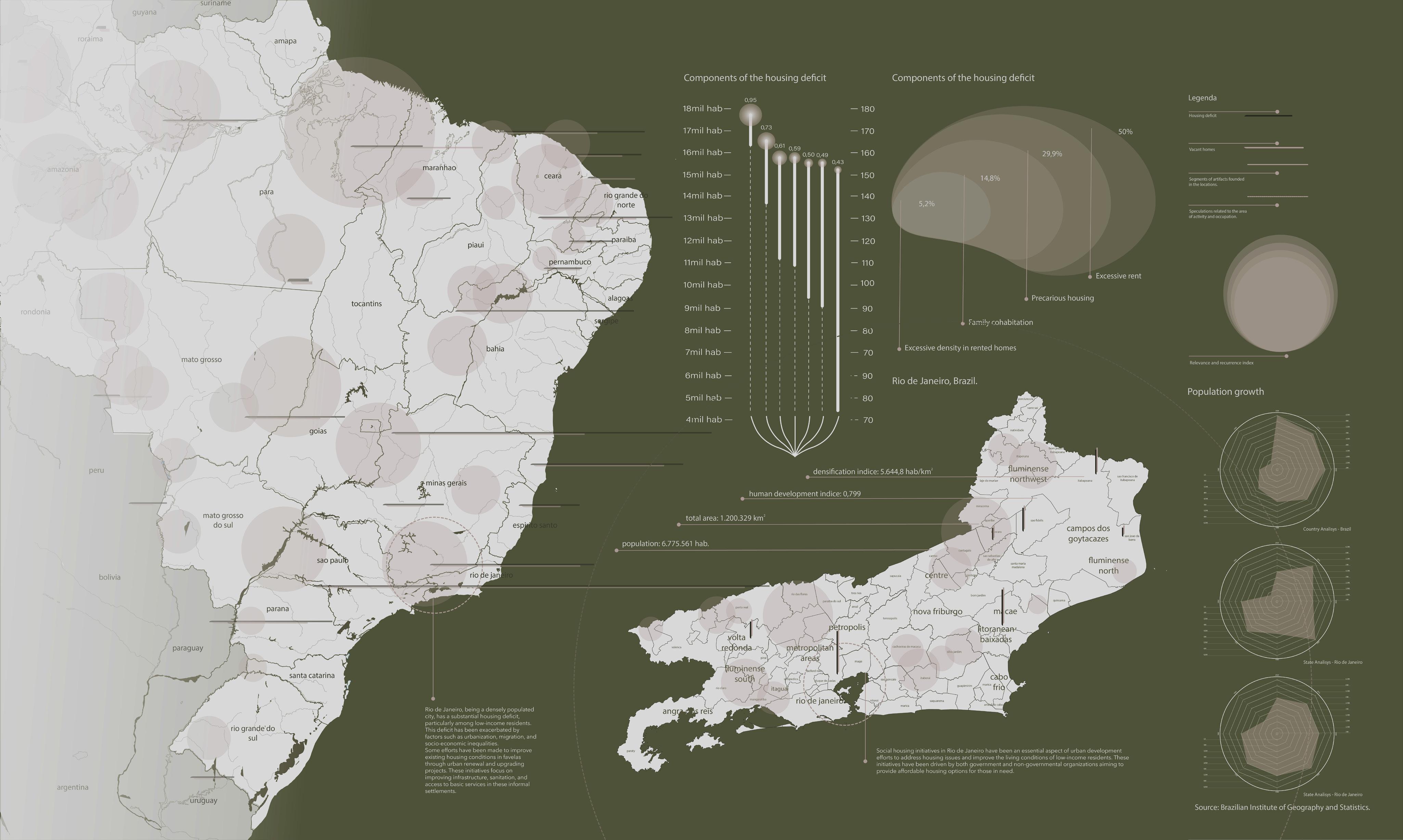
Brazilian Social Housing Panorama
in Rio de Janeiro
Tackling Environmental and Social Vulnerability
Community and Academia: Local insights informed research, while academic outputs empowered communities with data and tools.
Policymakers and Private Sector: Policies enabled investment opportunities, and private innovations supported policy implementation.
Community Engagement and Environmental Vulnerability
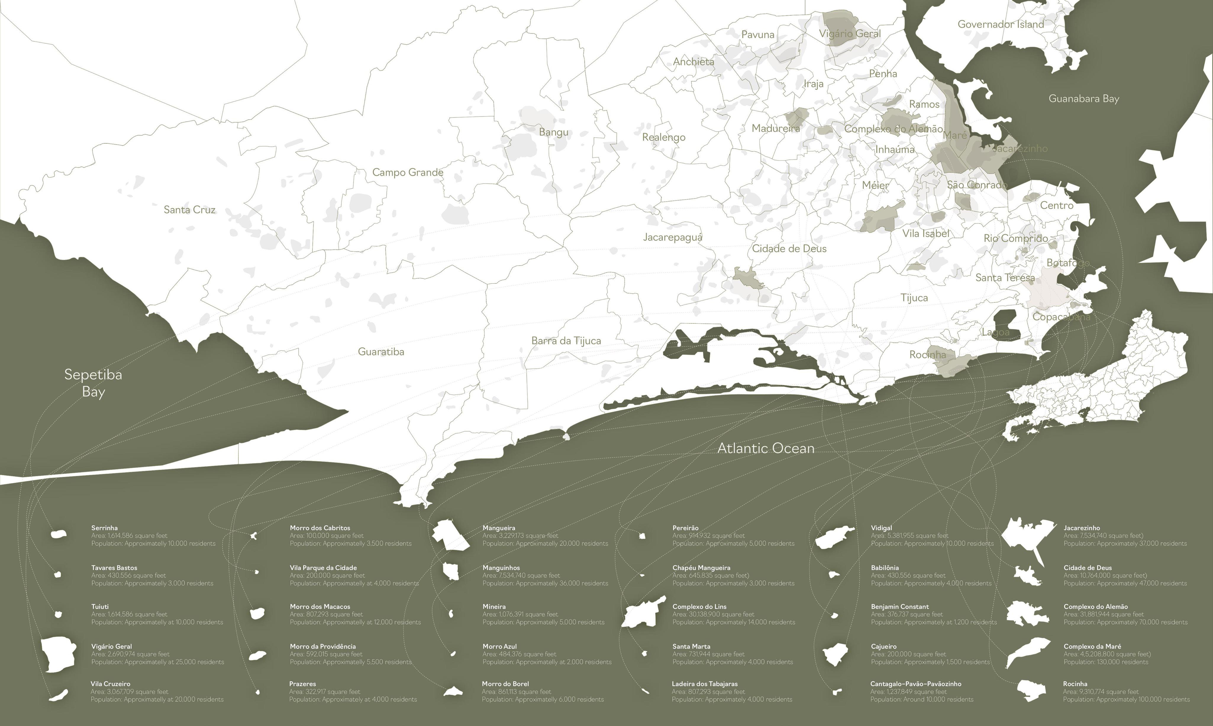
Rio’s geography exacerbates its vulnerability to climate change. From low-lying coastal areas to steep hillside favelas, the city’s diverse landscapes shape its exposure to environmental hazards such as landslides, floods, and rising sea levels. Informal settlements—home to nearly a quarter of Rio’s population—face acute risks due to inadequate infrastructure, deforestation, and limited access to basic services. For instance, favelas like Rocinha and Vidigal are particularly prone to landslides intensified by poor waste management and deforestation. Environmental degradation, including untreated sewage and industrial waste in Guanabara Bay, disproportionately impacts marginalized communities. These populations face heightened health risks from waterborne diseases and air pollution, further entrenching cycles of poverty and vulnerability. Addressing these inequities requires integrating social and environmental policies to build resilience and reduce risks.
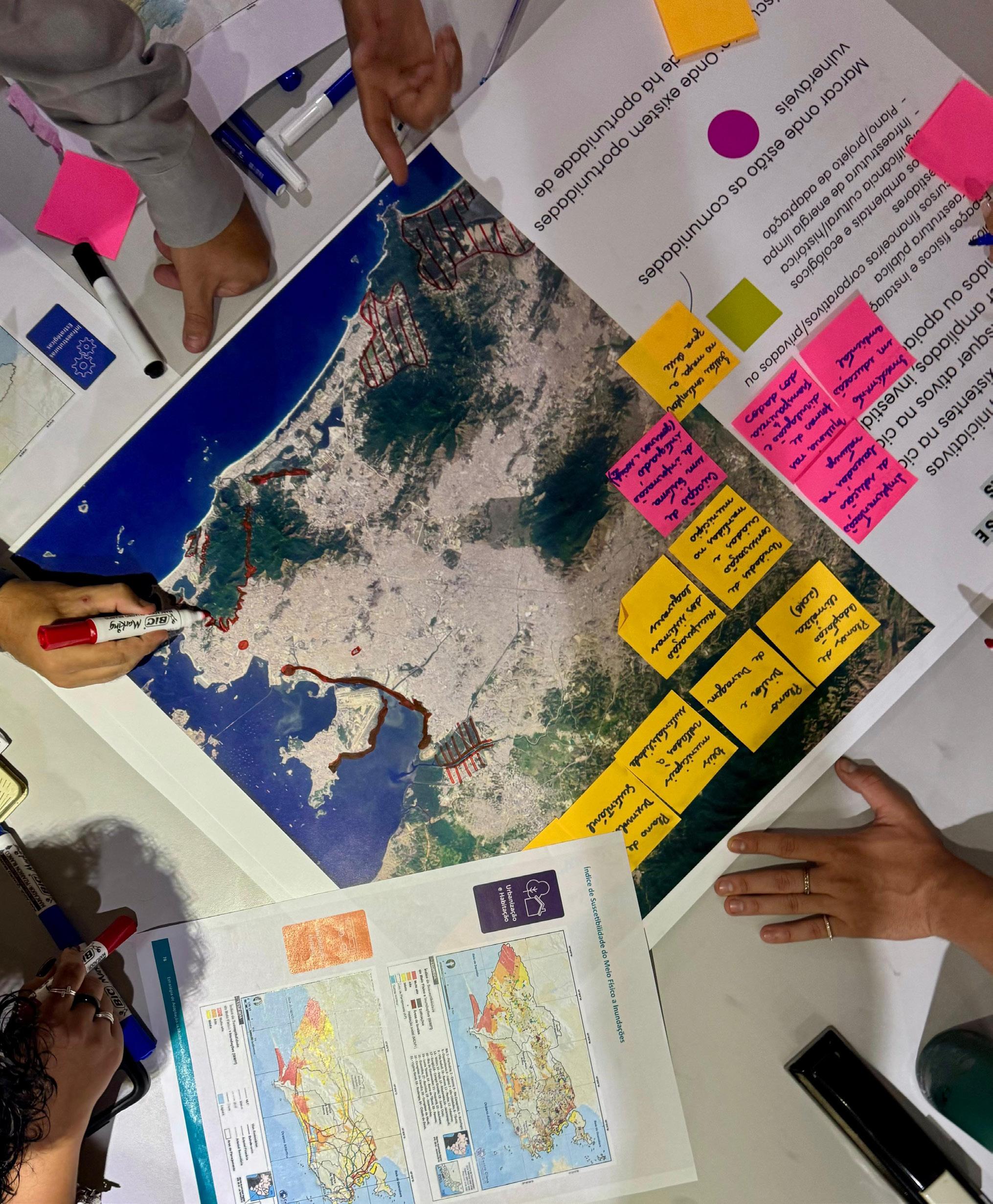
Community engagement is pivotal in creating sustainable solutions to Rio’s climate challenges. Grassroots organizations have demonstrated the power of collective action. Initiatives led by groups like Movimento dos Atingidos por Barragens highlight the importance of amplifying local voices in decision-making processes. For example, these organizations have successfully advocated for policy changes that prioritize vulnerable neighborhoods in disaster prevention and mitigation efforts. The involvement of communities in data generation and urban planning fosters inclusive development. Civil society’s tacit knowledge about local needs and vulnerabilities enriches academic and governmental efforts to address climate risks. Collaborative forums that bridge the gap between policymakers, researchers, and residents can help align priorities and ensure that adaptation strategies are contextually relevant and effective. Through collective action, the city can build a future where all residents thrive in harmony with their environment.
Income inequality and systemic discrimination, such as environmental racism, are significant barriers to equitable climate adaptation in Rio. Wealthier neighborhoods benefit from robust infrastructure and urban planning, while favelas lack basic amenities like reliable drainage systems and sewage networks. This disparity underscores the need for policies that explicitly address inequities. Programs like “Morar Carioca” and the “Programa de Urbanização de Assentamentos Populares” offer examples of how targeted investments can improve infrastructure in informal settlements. However, these initiatives must be expanded and designed in collaboration with local communities to ensure their success and sustainability. Additionally, prioritizing access to green spaces, cultural opportunities, and public services can help reduce systemic inequalities and foster social cohesion.
The findings from the Climate Hub Rio workshop underscore the value of interdisciplinary approaches to tackling Rio’s climate challenges. By integrating perspectives from academia, civil society, and government, stakeholders can co-design initiatives that address intersectional risks. For example, creating centralized data hubs that compile information on climate risks and vulnerabilities can improve accessibility and inform evidence-based decision-making. Investments in environmental education and participatory governance are equally crucial. Educating residents about climate risks and their rights empowers them to advocate for equitable adaptation measures. Establishing permanent forums for dialogue between civil society and policymakers ensures that diverse voices are heard and incorporated into urban planning processes. Rio de Janeiro’s path to resilience lies in addressing the systemic roots of its vulnerabilities. This includes tackling income inequality, promoting environmental justice, and fostering community-driven solutions.
Rio Climate Hub Workshop
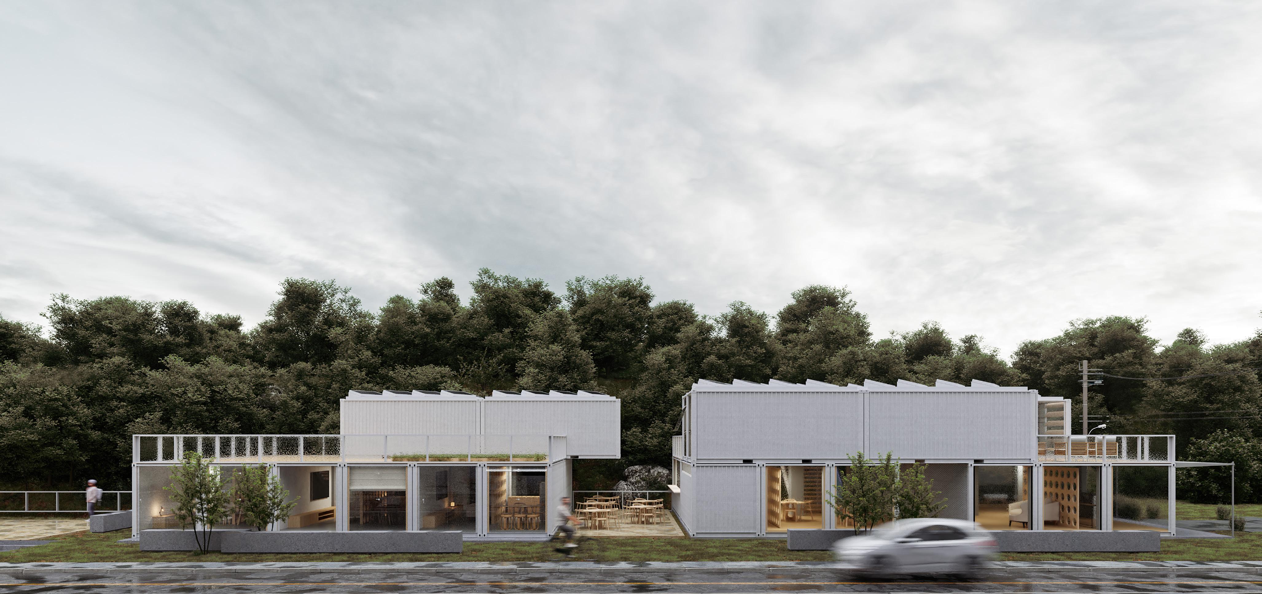
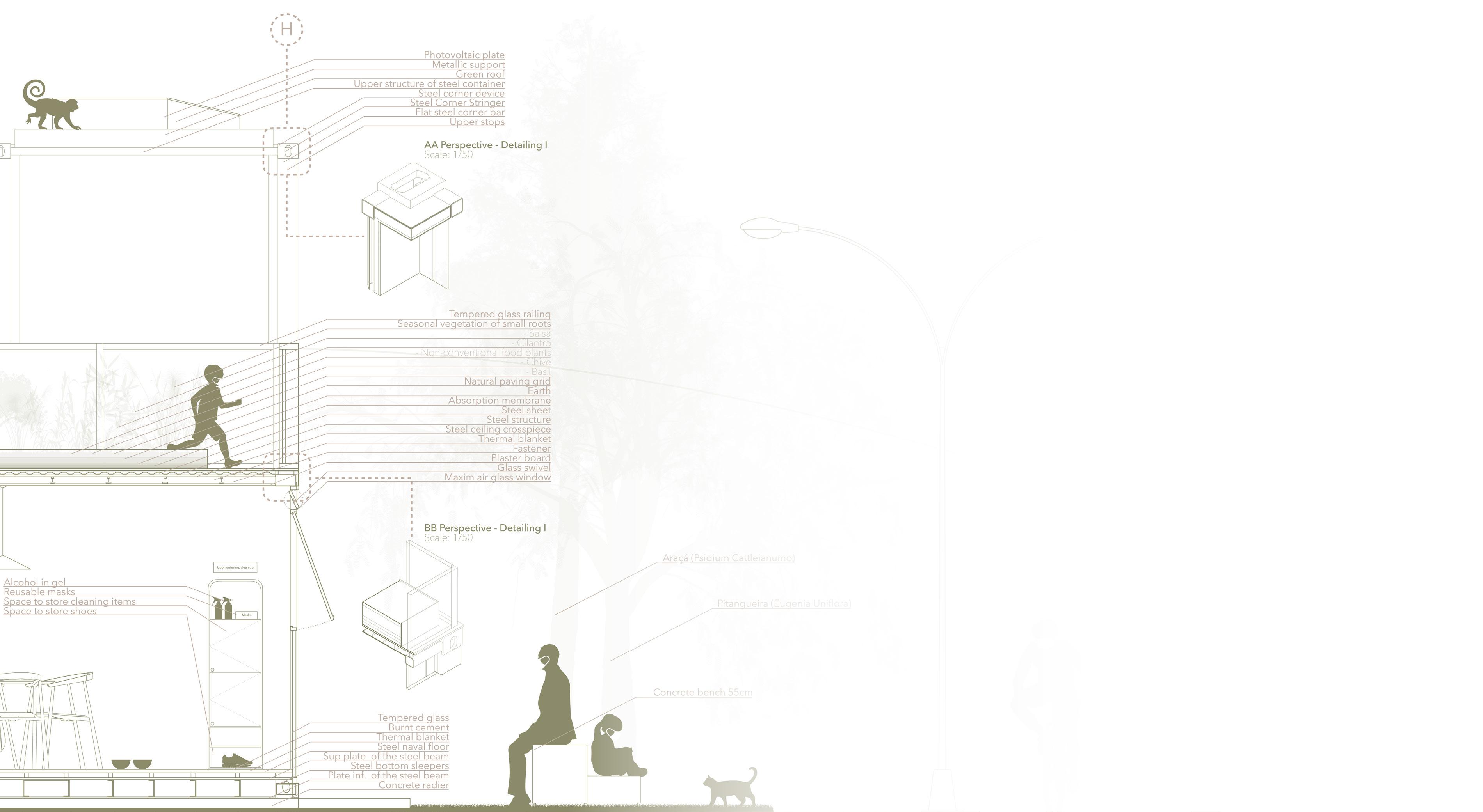
Longitudinal Section and First Ground Floor Plan +66.1m
Scale: 1/50
Mapping Informal Settlements in Rio de Janeiro Metropolitan Area
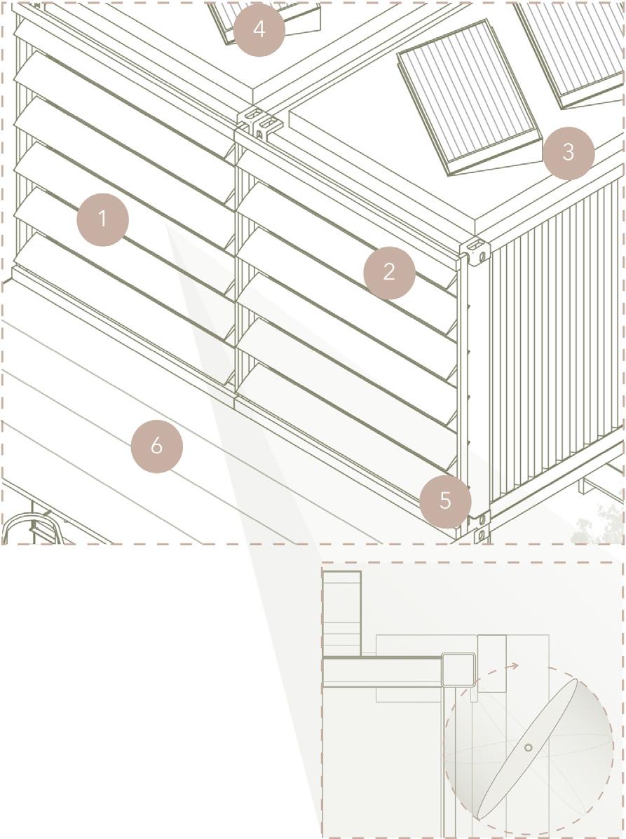
AA Detailing - Upper level mobile windshields
Scale: 1/75
Specifications
1. Mobile wood windshilds - 0.2m x 2.45m / 20º, 40º, 60º e 80º and 100º.
2. Metal structure of 12 feet cold formed container.
3. Green roof.
4. Monocrystalline silicon photovoltaic panel 0.5m x 1.50m.
5. Cold formed metal cover.
6. Sheet metal cold formed container 0.25m x 4.90m.