Central Crossing Fire Protection District, Shell Knob, MO Evergreen Investments
ADVERTISING SALES
Myra Thornton Find us
Publisher Myra Thornton
www.lostonthelake.us
email: hello@lostonthelake.us
Phone: 417-593-1167
The Dog Days Of Summer
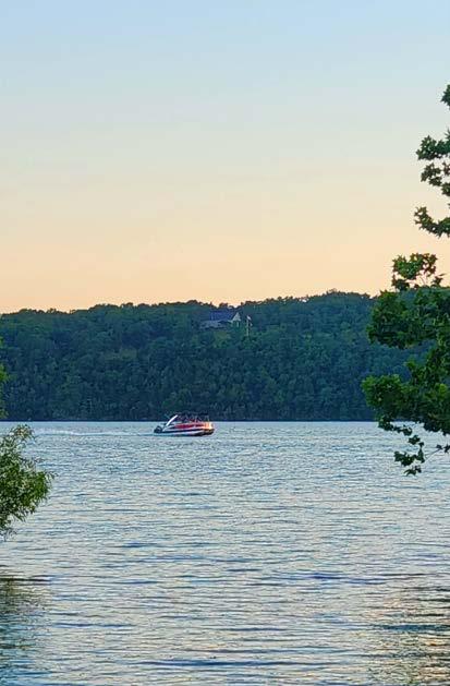
August on Table Rock Lake carries a magic all its own. The hum of boat motors begins early in the day as summer heats up. By afternoon, the lake comes alive with the vibrant energy of vacationers savoring these last golden days before fall whispers its arrival.
It’s a month of contrasts: stillness and celebration, leisure and adventure. Anglers find bass moving deeper into the cooler water, while families chase one more day of tubing, wakeboarding, and sunbathing. The restaurants along the shore buzz with sunset diners, and the sound of live music drifts across the water on weekend nights.
August reminds us why we love this lake—not just for its sparkling expanse or winding shoreline, but for the way it draws people together. Whether you’re docking for dinner, finding a hidden cove to swim, or simply watching the day fade into a fiery Ozarks sunset, Table Rock Lake in August feels like a celebration of summer’s very best.
So here’s to the lazy mornings, the big catches, the late-night laughter on the dock, and the memory-making days that remind us: life is better on the lake.
Be Happy,
Myra Thornton
A Summer Fishing Adventure
Table Rock Lake in August
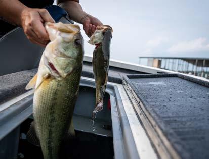
As summer peaks in the Ozarks, Table Rock Lake transforms into a warm-water haven for anglers. Nestled in the rolling hills of southern Missouri, this 43,000acre reservoir offers something for every fisherman, from seasoned bass chasers to families looking for a sun-soaked day of panfishing. Though August brings heat and high skies, the fishing remains rewarding — if you know where to look.
The Deep Summer Challenge
By August, Table Rock’s clear waters can reach surface temperatures in the low-90s, pushing most fish species into deeper, cooler layers. That means the easy shallow-water action of spring is long gone, replaced by a more tactical game. But don’t let that discourage you. Bass — largemouth, smallmouth, and spotted — are still feeding actively; they’re just holding tight to deep structure. Points, humps, ledges, and brush piles in 20 to 40 feet of water are prime territory.
The go-to method for summer bass is finesse fishing. Drop-shot rigs, football jigs, and soft plastic worms fished slowly over submerged structure are productive, especially early in the morning or just before dusk. Local pros also recommend flutter spoons and deep-diving crankbaits for suspended fish holding near thermoclines or deep bluff walls.
You’ve got to work a little harder in August. A good graph and a little patience and you’ll find them.
Beyond Bass
While bass may be the lake’s claim to fame, Table Rock’s other species are far from dormant. Bluegill and other sunfish remain aggressive throughout summer and are ideal for beginners and families. A simple worm under a bobber near docks, gravel points, or submerged timber often yields a mixed bag of panfish — plus the occasional goggle-eye (Ozark bass), a local favorite.
Catfish, especially channels and flatheads, offer solid nighttime action. Shorelines near Indian Point or the dam area are reliable hotspots. Using chicken liver, hot dogs, or nightcrawlers after dark can produce surprisingly big results.
Walleye are deeper still, often found in main-lake channels and river arms like the James or Long Creek. Trolling with spoons or bottom bouncers can be effective, though these fish require some hunting and the right gear.
Timing and Tactics
In August, timing is everything. The best bites typically occur
at first light or the hour before sunset, when fish rise slightly in the water column and feed more aggressively. During midday heat, focus on deeper water or take a break and enjoy the lake’s clear swimming coves and shaded shorelines.
Boat anglers definitely have an edge this time of year, but shore fishing isn’t out of the question. Public access points and parks offer opportunities for panfish and catfish without ever stepping foot on a boat.
Hooked on the Ozarks
Despite the challenges of sum-
mer fishing, Table Rock Lake delivers in both scenery and species. Whether you’re scan ning deep structure for a tro phy smallmouth or pulling pan fish with your kids off a dock, August fishing here is a rich and rewarding experience.
Just don’t forget your sunscreen — and your drop-shot rig.
Need more advice, bait tips, or a local guide recommenda tion? Drop me a line — Table Rock has a fish with your name on it.
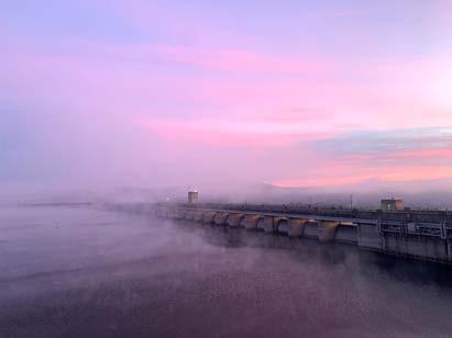
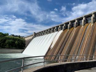
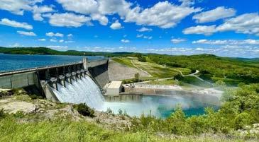
Why Table Rock Lake Empties First
Photo by: SWL-PAO
By Erin Jimenez Little Rock District USACE
The U.S. Army Corps of Engineers (USACE) hydropower mission is to provide a reliable source of electricity, reduce the amount of greenhouse gases produced, and reduce the dependence on fossil fuels such as coal, oil, and natural gas.
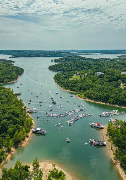
If you’ve ever spent time around Table Rock Lake when the lake level is high after repeated heavy rainfall events, you may have noticed something curious. The water levels here start dropping before you see any change at nearby Beaver Lake or even the massive Bull Shoals Lake downstream.
The gradual drop in lake levels after reservoirs fill up might seem random, but it’s part of a deliberate pattern. Behind this carefully managed drop lies a story of geography, topography, engineering and a flood control strategy that protects thousands of people across northwest Arkansas and southern Missouri.
Although Table Rock has more storage than Beaver, it also receives more uncontrolled local runoff, meaning it will fill up nearly twice as fast for the same storm. This makes lowering Table Rock’s flood pool first, a priority.
White River Water Control
Table Rock, Beaver and Bull Shoals are three of five major flood control reservoirs located along the White River, each serving multiple roles. These include reducing flood risks, generating hydropower, supplying drinking water and offering popular spots for recreation. These three lakes sit like stepping stones along the main river’s path and work to-
gether as a coordinated system. The other two reservoirs, Clearwater and Norfork, also provide these important benefits but sit outside the main stem of the White River.
However, anyone familiar with lake level changes may notice a pattern: Table Rock tends to be drawn down first, well before Beaver and Bull Shoals. This is not a coincidence, it’s a deliberate part of a larger flood risk management strategy controlled by the U.S. Army Corps of Engineers, Little Rock District.
The water control plan behind reducing floods in the White River Basin centers on Table Rock. Beaver, located near Rogers, Arkansas, is the first and most upstream reservoir in the chain. Farther downstream sits Table Rock near Branson, Missouri, followed by Bull Shoals near Mountain Home, Arkansas. During heavy rains, water flows downhill through this system, filling Beaver first, then Table Rock, and finally Bull Shoals.
That order is critical. Releasing from Beaver too early pushes the problem downstream before the system is ready to handle it. To prevent that, between heavy rains, engineers intentionally lower Table Rock’s levels faster than Beaver’s or Bull Shoals’. This “first to fall” strategy gives Table Rock room to catch rising floodwaters, helping prevent the river from spilling over its banks and threatening communities downstream.
If Table Rock didn’t make space first, additional water from Beaver could overwhelm the system, leading to dangerous flooding both locally and further downstream near Bull Shoals.
Table Rock acts as the middle “catch basin” in the chain due to its central location. Beaver releases water upstream, Table Rock absorbs that flow in the middle and Bull Shoals manages what remains downstream.
If USACE were to empty Beaver be-
cont. pg 14
fore Table Rock, it would disrupt this delicate balance. Since Beaver is upstream, any large release from it flows directly into Table Rock. If Table Rock hasn’t been drawn down enough to receive that surge, it could quickly reach capacity, forcing emergency releases and increasing flood risk downstream.
The same principle applies to Bull Shoals. As the final reservoir in the chain, it’s designed to hold water from both Beaver and Table Rock. If Bull Shoals is lowered too early, it may begin to refill rapidly once inflows arrive from upstream. Without careful timing, it could lose the ability to buffer floodwaters and be forced into high-volume releases, threatening downstream communities.
That’s why preserving Bull Shoals’ capacity, and managing Table Rock first, is essential. The system operates best when floodwaters are passed downstream in a controlled, stepwise fashion, maintaining enough storage in each reservoir to adapt to future storms.
White River Flood Control Development
These lakes weren’t built all at once. The construction of the Table Rock, Bull Shoals and Beaver were authorized through a series of Flood Control Acts passed by Congress. Bull Shoals got the green light first in 1938 and was completed in 1951. Table Rock followed with authorization in 1941 and completion in 1958 and Beaver was authorized in 1954 and completed in 1966.
Bull Shoals and Table Rock were prioritized earlier because, at the time
of their authorization, controlling floods closer to larger populated areas and the main river channel was urgent. Building those dams first helped reduce the most immediate flood risks downstream.
By the time Beaver was authorized in 1954, the earlier dams had already significantly improved flood control. However, as northwest Arkansas grew in the mid-20th century, especially near Rogers and Springdale, the need for more drinking water and flood protection upstream led to Beaver Lake’s creation.
Today, all three lakes work as a team, managed by hydraulic engineers in the Little Rock District. They carefully monitor water levels, weather forecasts and river flows. Their goal is to keep communities safe, provide reliable water and support power generation while preserving these beautiful lakes for recreation.
While Table Rock, Beaver and Bull Shoals form the backbone of flood control along the White River, the system as it stands today isn’t exactly what engineers originally envisioned.
Between the 1920s and 1940s, engineers collected flood data that clearly demonstrated the need for additional dams to better manage the White River Basin. As part of early flood control planning, 11 more dams were proposed. Five in the upper White River Basin and six in the Black River Basin, which feeds into the White. These projects were intended to complement the existing reservoirs by adding extra layers of flood protection and improving overall water management.
However, a combination of funding shortfalls, public opposition and logistical hurdles ultimately prevented those dams from being built.
“The dams we have now along the White River provide only about 45% of the total flood control capacity needed,” said Mike Biggs chief of hydraulics & technical services branch for the Little Rock District. “The Black River Basin is actually our largest uncontrolled area. That’s important because Newport serves as the key regulating point, everything flows down to Newport, and that’s where we manage flood stages.”
This year, the Little Rock District recorded a stage of 33.3 feet at Newport, the third highest since the dams were first built in the region in the 1940s.
This level is comparable to the historic flood of 2011 which was also driven entirely by uncontrolled flows. In the 1950s, the regulating stage at Newport was set at 25 feet during the winter and spring, and 21 feet to
18 feet during the agricultural season. Over time, legislative changes have adjusted these stages to the current levels: 21 feet, 14 feet and 12 feet, respectively.
Because the additional dams were never constructed, the current flood control system operates without those planned buffers. As a result, managing Table Rock and the other key reservoirs has become even more critical. It’s a strong reminder that while the White River flood control system is effective, it’s far from perfect. Its continued success relies on careful coordination, real-time decision-making, and the ability to adapt to changing conditions.
So, the next time you’re standing on the shores of Table Rock Lake, watching the water slowly recede after a storm, know that you’re witnessing more than a natural cycle you’re seeing a strategy in motion. This isn’t just a lake draining; it’s a calculated move in a decades-old engineering choreography designed to shield thousands from harm.
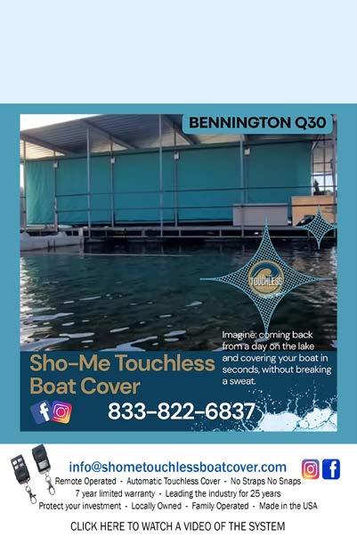
27-Years of Innovation Comes Down to One Button
Protect Your Investment and Your Back will Thank You
Protecting your investment is our priority! For 27 years, Touchless Boat Cover has been the leader in remote-operated boat covers, known for quality, durability, and innovation. We’re not just another boat cover; we’re the original and the best! Our covers are built to last, backed by an industry-leading 7-year manufacturer’s warranty. Choose from 10 stock colors and 10 custom colors to match your boat and style. Plus, with lead times of only 4 weeks, you’ll be covered in no time! See the difference quality makes.
Shelled Sunbathers
Table Rock Lake
Shelled Sunbathers
Lake Water TurtleS
Table Rock Lake is home to several freshwater turtles that thrive in its sheltered coves, rocky outcrops, and calm backwaters. If you’ve ever noticed a sudden plunk as something slipped off a log into the water as your boat approached, chances are you’ve startled a basking turtle — a common but often overlooked resident of this scenic reservoir.
Meet the ReSidentS: MiSSouri’S MoSt Common Lake TurtleS
Red-Eared Slider (Trachemys scripta elegans)
The red-eared slider is arguably the lake’s most visible turtle. These mid-sized turtles are easy to spot thanks to the distinctive red or orange stripe behind each eye. They’re avid sunbathers, often seen lined up like soldiers on logs, rocks, or even dock pilings. Redeared sliders are omnivores and will happily eat aquatic plants, insects, fish eggs, or even bits of bait left by anglers. In Missouri, they’re abundant — and in Table Rock Lake, they’re practically everywhere.
Common Snapping Turtle (Chelydra serpentina)
Lurking beneath the water’s surface with only its eyes and nostrils exposed, the snapping turtle is the lake’s heavyweight bruiser. These prehistoric-looking turtles can grow up to 18 inches long and weigh over 30 cont page 20
pounds. Their strong jaws and tough demeanor make them fascinating — but not friendly — to encounter. Unlike sliders, snappers rarely bask and prefer murky bottoms or submerged debris for concealment. Though they look intimidating, they’re generally shy and would rather retreat than confront humans.
Eastern River Cooter (Pseudemys concinna)
A more streamlined and graceful turtle, the river cooter is often mistaken for the red-eared slider. It has a dark green shell with yellow markings and a strong preference for clean, flowing water — making Table Rock’s clearer tributaries an ideal habitat. Cooters are mostly herbivorous, feasting on aquatic vegetation and algae. They’re shy and quick to dive when disturbed, but they’re frequently seen basking solo on mid-lake rocks or tree stumps.
True to its name, the map turtle’s shell is etched with swirling, map-like patterns that look almost hand-drawn. These turtles prefer rocky shorelines and deeper water, where they hunt small crustaceans and insects. Map turtles are the most skittish of the bunch — good luck getting close. They’re sensitive to motion and will slide off their perch at the slightest hint of approach. However, patient observers, especially those in kayaks or canoes, might catch a closer glimpse.
Life on the Lake: Habitat, Behavior, and Nesting
Turtles are cold-blooded, meaning their activity depends on environmental temperatures. In the summer, they bask to regulate their body heat, and Table Rock offers an abundance of
perfect basking spots — from sun-soaked rocks to floating branches. Most turtles here are diurnal, active during daylight hours and retreating into the water to rest or avoid predators.
Spring through early summer is the nesting season. Female turtles often emerge from the water to find sandy or loose soil, where they dig shallow nests and lay their eggs — sometimes near trails, boat ramps, or the edges of campgrounds. Hatchlings emerge late summer to early fall, but many face threats from predators like raccoons, birds, and even fish before they make it back to the water.
In winter, turtles don’t migrate. Instead, they hibernate beneath the surface, burrowed into the muddy lakebed. Their metabolism slows dramatically, and they can absorb oxygen through specialized tissues in their throat and cloaca, allowing them to survive for months without surfacing.
Respecting Their Role
Turtles play a vital role in maintaining the lake’s ecological balance. They help control insect populations, recycle nutrients, and keep aquatic vegetation in check. While it may be tempting to handle or feed a basking turtle, it’s best to observe from a distance. Feeding wild turtles can disrupt their diet and increase risk from predators and human interaction.
Table Rock State Park is one of the best places to spot turtles in action. Whether you’re a nature lover, photographer, or just curious, take a moment this summer to slow down and appreciate these ancient reptiles.
In a world that seems to move faster each year, Table Rock’s turtles offer a reminder: sometimes the best way to experience the lake is at a turtle’s pace.
Fresh Recipe The Rogue Chef
Grilled Cajun Fish Bowls
Time: 35-45 Minutes
Servings: 4 Servings
Preheat your oven to 350°F.
Ingredients
For the Cajun Fish:
● 11⁄2 Lbs Firm Cod
● 11⁄2 T Cajun Seasoning
● 1 T Olive Oil
● Salt and Black Pepper, to taste
● Lemon Wedges, for serving
For the Bowls:
● 2 C Cooked White Rice
● 1 C Corn, thawed frozen
● 1 C Black Beans, rinsed and drained
● 1 Avocado, sliced
● 1 C Cherry Tomatoes, halved
● 1⁄2 C Red Onion, thinly sliced
● 1⁄4 C Chopped Fresh Cilantro
● Lime Wedges, for serving
Cajun-Lime Sauce:
● 1⁄2 C Greek Yogurt or Sour Cream
● 1 T Lime Juice
● 1 tsp Cajun Seasoning
● Pinch of Salt
● Splash of Water, to thin
Instructions
Season the Fish
1. Pat the fish dry with paper towels.
2. Rub each fillet with olive oil on both sides.
3. Sprinkle Cajun seasoning evenly over the fillets and press it in gently.
4. Add salt and pepper to taste.
Grill the Fish
5. Preheat a grill or grill pan over medium-high heat.
6. Brush the grates lightly with oil to prevent sticking.
7. Place the fish on the grill and cook for 3–4 minutes per side, or until the fish is opaque and flakes easily with a fork.
8. Remove from heat and squeeze lemon over the top.
Make the Sauce
9. Whisk together yogurt, lime juice, Cajun seasoning, and a pinch of salt in a small bowl.
10. Thin with a splash of water until drizzle consistency is reached.
11. Set aside until ready to serve.
Build the Bowls
12. Scoop rice into four serving bowls.
13. Top with equal portions of grilled fish.
14. Add corn, black beans, avocado slices, cherry tomatoes, red onion, and cilantro.
15. Drizzle with the Cajun-lime sauce.
16. Serve with lime wedges for squeezing.
Go Rogue by swapping the fish for grilled shrimp, tofu, or chicken. Use quinoa or shredded cabbage instead of rice for a low-carb base.
Want The Rogue Chef to prepare this dish or any other meal for you? Contact us at: www.TheRogueChef.com.
Understanding Straight-Line Winds
When most people hear the word storm damage, they immediately picture a tornado twisting across a field, pulling trees from the earth and throwing debris into the sky. But what if the wind comes with the same fury—just without the spin?
Meet the straight-line wind, nature’s unsung powerhouse. Lacking the rotational drama of tornadoes, these winds often go unnoticed in headlines, yet they’re responsible for some of the most widespread and costly storm damage across the United States each year.
What Exactly Are StraightLine Winds?
Straight-line winds are just what they sound like: powerful winds that travel in a single direction. They’re typically born from severe thunderstorms, when masses of cool air plummet downward from the storm and hit
the ground with explosive force, spreading out horizontally at speeds that can exceed 100 miles per hour.
While tornadoes twist destructively in a narrow column, straight-line winds barrel forward in a broad swath—sometimes dozens or even hundreds of miles wide. The result? Massive, often unrelenting damage that can mimic or exceed that of smaller tornadoes.
Types of Straight-Line Wind Events
There’s a spectrum of straightline wind events, but a few deserve special mention:
Microbursts:
These are small but intense downdrafts of air that descend rapidly and fan out when they hit the ground, producing powerful, localized wind damage. Pilots dread them—microbursts
cont page 26
have been responsible for multiple aviation disasters due to the sudden, violent wind shear they cause.
Derechos:
These are the titans of straight-line wind events - massive, long-lasting windstorms produced by fast-moving bands of thunderstorms. To qualify as a derecho, the storm must leave behind a trail of damage over at least 250 miles, with wind gusts of at least 58 mph, and numerous reports of gusts over 75 mph.
How Can You Tell It Was Straight-Line Wind?
While the damage may look similar at first glance, meteorologists can usually distinguish between tornadoes and straight-line winds by examining the direction of debris.
Tornado damage often appears scattered and chaotic, with debris flung in multiple directions. Straight-line winds, by contrast, tend to knock trees and structures in the same direction, creating a pattern that looks like a giant hand swept across the land.
Why You Should Take Them Seriously
Straight-line winds are often underestimated by the public. Tornado warnings grab attention because of their drama,
but straight-line winds are frequently stronger, longer-lasting, and more widespread. They’ve knocked down entire forests, toppled power grids, and damaged hundreds of homes in a single sweep.
In August 2020, a derecho slammed through the Midwest, with wind gusts over 140 mph in some areas. It flattened crops across Iowa, leaving over $11 billion in damage—more than many hurricanes or tornado outbreaks that same year.
Staying Safe
Because they often accompany severe thunderstorms, straightline winds usually come with a Severe Thunderstorm Warning—but not always a Tornado Warning. That can create a false sense of security.
Here’s what to do if straight-line winds are approaching:
Get indoors and stay away from windows.
Avoid trees or large open areas like fields or lakes.
Secure or bring inside loose outdoor items—grills, patio furniture, and trampolines can become dangerous projectiles.
Stay alert for fallen power lines and never assume they’re safe.
The Bigger Picture
As climate change brings more extreme weather patterns, meteorologists are seeing an increase in high-intensity wind events, including derechos and severe thunderstorm outbreaks that produce strong straight-line winds.
Understanding the risks these winds pose is critical—not just for storm chasers and emergency planners, but for everyday people who may only get minutes of warning.
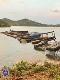
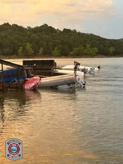
Recent damage to local docks in Shell Knob due to high winds. Always pay attention to warnings and weather when on the water.
Photos By: Central Crossing Fire Protection District, Shell Knob, MO
Financial Focus
DOES THE 4% RULE STILL MAKE SENSE FOR YOUR RETIREMENT?
You may have heard of the “4% rule” when it comes to retirement. The idea is simple: After you retire, you withdraw 4% of your investment portfolio each year. In theory, this helps ensure your savings last for your lifetime. While this rule can be a helpful starting point, it’s not a one-size-fits-all — and it’s definitely not a substitute for a plan tailored to your specific needs, wants and wishes.
The truth is, how much to withdraw in retirement depends on factors like when you retire, if you’ll work part time, how long you expect retirement to last, your lifestyle goals, inflation and whether you want to leave a financial legacy to heirs. So, the 4% rule should be viewed as more of a guide than a strict rule.
Let’s start with age. The 4% rule is often based on someone retiring at 65 and expecting to live until about 92. But if you retire earlier, you may want your portfolio to stretch further. In that case, you might need to start with a lower withdrawal rate, maybe closer to 3%. And if you retire later, you might safely withdraw a little more — perhaps 4.5% to 5% — depending on your financial situation.
Your retirement lifestyle also plays
a big role. Are you planning to travel the world or spend more time at home? If you expect higher spending in the early years of retirement, you may need to adjust your withdrawal rate or plan to reduce spending later to balance things out.
Your financial flexibility matters too. If you have less wiggle room with your expenses, rely heavily on your portfolio for income or want to preserve wealth for your heirs, a more conservative approach might be wise. In this conservative scenario, your portfolio withdrawals may be met from interest and dividends. Think of your withdrawal rate as existing on a spectrum from more conservative to less conservative, with your personal situation determining where you land.
Then there’s inflation. A well-built strategy usually includes small annual increases in withdrawals to keep up with rising costs — about 2.75% per year. But you don’t need to take a raise just because the calendar says so. If the markets have had a tough year or you don’t need the extra income, it might be smart to skip an increase. Being flexible can improve the chances your money will last.
It’s also important to understand
what’s known as your “portfolio reliance rate” — how much of your retirement income comes from your investments versus other sources like Social Security or pensions. The higher this percentage, the more conservative you may want to be with withdrawals.
And don’t forget the IRS. If you’re drawing from a traditional IRA or 401(k), you’ll need to take required minimum distributions (RMDs) once you reach age 73. Your RMD for any year is the account balance as of the end of the prior calendar year divided by a life expectancy factor according to the IRS. These RMDs need to be accounted for in your strategy.
The bottom line? The 4% rule is a useful starting point, but it’s just that — a starting point. A good financial advisor can help you build a strategy that reflects your age, your goals and your full financial picture. By revisiting your plan regularly and staying flexible, you’ll give yourself the best shot at turning your savings into a secure, fulfilling retirement.
This article was written by Edward JonesforusebyyourlocalEdward Jones Financial Advisor. Edward Jones, Member SIPC
Edward Jones, its employees and financial advisors cannot provide tax or legal advice. You should consult your attorney or qualified tax advisor regarding your situation.
Presented by our local Edward Jones Financial Advisor: Grant Beasley 417-739-5575
Not So Naked... Nakedpalooza 2025
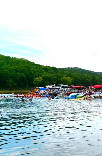
Where:
Naked CoveTable Rock Lake
Aka Whites Branch
When:
12 PM – 5 PM
Ready to soak up the sun and celebrate summer with good vibes and great company? Head to Whites Branch Cove— known by locals as “Naked Cove”—for an adult float party that’s sure to make waves!
No, it’s not a “naked” party— but you will see plenty of folks dressed in next to nothing and enjoying generous amounts of adult beverages. This is a float and tie-up gathering, so consider leaving the kids at home.
Safety & Courtesy First:
• Approach slowly: Boats will be anchored along the edges with large tie-ups in the center.
• Treat the entire area as a no-wake zone to protect swimmers, paddlecraft, and anchored vessels.
• Be respectful: This is an informal gathering-keeping things fun and safe is on all of us.
• Law enforcement may be present—so make sure your boat is legal, your drinks are responsibly managed, and everyone knows the lake rules.
• Bring your floaties, coolers, and party playlists—but most importantly, bring good energy. Let’s keep NakedPalooza the kind of legend worth repeating every summer.
Photo By: Matt Lekawa Photography
Evergreen CryStal Palace
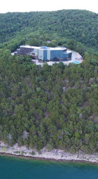
What Is That Thing on the Bluff?
If you’ve ever spent time on Table Rock Lake, chances are you’ve looked up at the ridge and asked: “What on earth is that building?”
That striking structure looming 200 feet above the water is the Evergreen Crystal Palace, also known as the Evergreen Lake Estate—a sprawling, surreal, and somewhat controversial architectural landmark. With its glass walls, green marble, and golden brass finishes, it sits on approximately 350 acres of wooded bluffland, boasting one of the most commanding views in the entire Ozarks.
Designed by architect Dennis Spencer in the early 1990s for businessman Robert W. Plaster, this five-level, 25,000–28,000 sq ft compound was envisioned as both
a lavish private residence and a high-end corporate retreat. Today, it feels more like a time capsule—frozen in an era of early-90s grandeur and unrestrained ambition.
At the center of the home is a multi-story glass atrium that blurs the line between architecture and nature, offering panoramic lake views from nearly every angle. The interior is a labyrinth of opulent features:
• Two master suites
• Over a dozen guest rooms
• Multiple kitchens
• Caretaker quarters
• Conference rooms and offices
• An indoor shooting range
You can move between levels via elegant marble staircases or the built-in elevator.
Photos by: Evergreen Investments
Additional highlights include:
• A sprawling 8,000 sq ft garage that fits up to 20 vehicles
• A helipad for private arrivals
• A private boat dock and four lakefront peninsulas
• Two time capsules, sealed in the atrium, scheduled to be opened in 2042 and 2092
Love it or loathe it, the Evergreen Crystal Palace is no ordinary lakeside mansion. Some have compared it to an office park or a movie set—half corporate HQ, half opera house. Reactions from locals and visitors run the gamut from “a Table Rock legend” to “what was he thinking?” But one thing everyone agrees on: it breaks every rule in the design book.
Last listed for around $49 million, the estate has been on and off the market for years, waiting for the right buyer—someone as eccentric, bold, and visionary as the estate itself.
Whether restored to its original glory or reimagined entirely, the property offers 360-degree views, unmatched privacy, and endless potential for transformation.
More than just a home, the Evergreen Crystal Palace is an idea carved into glass and stone—a relic of wild dreams, frozen ambition, and unapologetic scale. For the right buyer, it’s a once-in-a-lifetime chance to own one of the most unique pieces of real estate in the American heartland.
Whether it’s investing some extra income, preparing a future for your family with your retirement secured, or saving for a home or education costs, we’re here to coach you through it.
Contact us today to start creating a financial strategy tailored to your specific needs.