Live Flood Ready
Plan. Prepare. Act.

Plan. Prepare. Act.
Lismore is built on a floodplain. While we all hope we will never see a repeat of the February 2022 natural disaster, one thing is certain – Lismore will flood again. This begs the question – are you and your family flood prepared? This document provides lots of information and debunks some common myths and misconceptions.
While Council operates an extensive network of levees, pumps and gates to keep the city safe, there is only so much mitigation measures can do. Climate change means we all must make sure we are prepared for the next flood.
The NSW State Emergency Service (SES) is the lead agency for floods and storms, but several agencies work together to support the NSW SES during flood events.
As a quick guide, this is the job of each agency during floods:
• Bureau of Meteorology – provides weather warnings, storm warnings, flood watches and flood warnings
• NSW SES – provides local advice relevant to the latest BOM flood warnings, including evacuation warnings and orders
• Council – repairs damage to public spaces and infrastructure such as roads
The NSW SES is the organisation to turn to if you have damage from floods or storms to your home or property. All calls for help should go to 132 500 and in an emergency situation, always call Triple Zero (000).
Other agencies such as Council and our local ABC North Coast radio station will share advice from the SES, but the SES is always the source of truth in flood and storm events.
Council supports the SES by distributing information and our job is to keep essential services working throughout a flood. For instance, while the SES might come to fix a leak in your roof caused by a falling branch, it is Council’s job to remove trees blocking roads.
Council works throughout flood and storm events to ensure public infrastructure continues to operate and once the water recedes, we help in recovery by cleaning and rebuilding our public spaces.
We hope you find some useful information in this special edition of Local Matters. Please remember if you live or work in a flood city such as Lismore, you need to know your risk and have a plan for floods.
Lismore will flood again. That’s a fact!
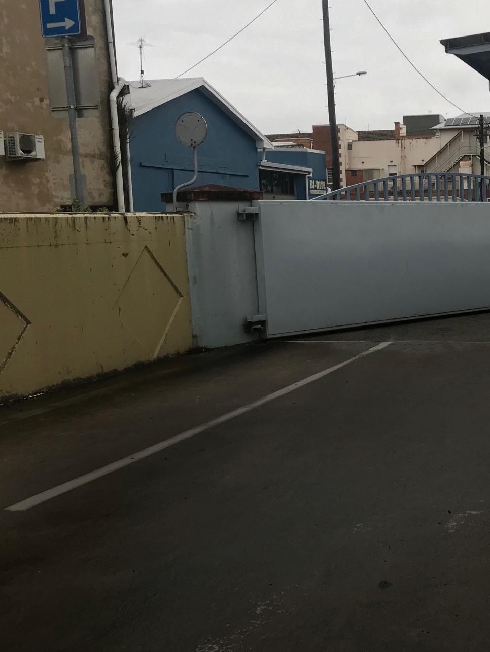
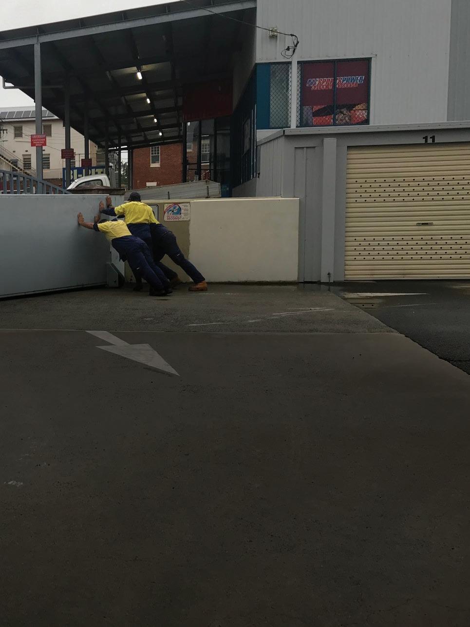
There are 32 gates along the levee that Council staff close at varying stages depending on the river level.
The first three gates at Upper and Lower Hollingworth Creek (South of Kyogle Road and at Riverview park) and Gasworks Creek are closed when the river reaches 4m. All other gates are closed in a specific sequence when the river reaches or is predicted to reach 5, 6 and 7m. The final gates under 11 Molesworth Street are closed at 9m.
The temporary pop up deflector walls in Keen Street and Richmond Lane are constructed when it is predicted that the levee will over-top.
Timing of the closure of some gates can vary depending on whether cars are still parked in the Kirklands Riviera, Rowing Club, and the Upper and Lower Hensley carparks behind the levee wall.
When severe weather is predicted, motorists should not park in carparks on the river side of the levee as vehicles may be damaged by rising flood waters.
There are five Deflector Walls within the Brown Creek Floodway.
These are designed to provide some protection to the buildings within the floodway from fast flowing water when the levee overtops through the Browns Creek Floodway.
They are at the Clive Campbell Carpark toilet block, the driveway to bottle shop behind Mary G’s, Keen Street at Singh’s Tyre and Mechanical and Lismore Antiques and Richmond Lane.
The CBD and South Lismore 10% Average Exceedance Probability
Since it was built, it has only overtopped three times in March 2017, and February and March 2022.
The lowest and first overtopping point is at the spillway opposite the old Police Station in Molesworth St. However, even though the design height of the levee is 10.95m at the spillway, the levee may actually overtop when the official Wilsons River Height gauge at the Rowing Club is around 10.2 – 10.6m (with 10.2m being possibly the worst case). This depends on the amount of rain falling in the Leycester and Wilson catchments and the downhill slope of the surface of the flood water. The slope varies from flood to flood. The variable level at which the river will overtop is due to the overtopping point being located some 500m or so up river from the official gauge site.
Lismore levees are designed to protect the city from a
event (formerly referred to as a 1-in-10-year flood).
The second overtopping point is at Gasworks Creek south of the CBD which has a design level of 11.3m. The third overtopping point is in Spinks Park where the levee wall has a design level of 11.6m. The inundation is staged and the overtopping points positioned in order to minimise the impacts of fast flowing water on properties and infrastructure as it flows in.
Our second levee is designed to protect South Lismore also from a 10% AEP. It has two sections which are between the Bruxner Highway and Wilson Street (4.7km) and Riverview Park to Wardell Street (400m).
The South Lismore Levee is designed to overtop at Caniaba Street, north of Three Chain Road at 11.55m, flowing into Hollingworth creek, but can overtop anywhere north from here, depending on flows from Leycester Creek.
There is a range of large and small pumps that are activated during a flood to extract rainwater from within the levee walls and pump it into the Wilsons River.
All pumps have been restored to pre-February 2022 conditions.
The largest two pumps are at the Browns Creek Pump Station. They are the original pumps from the 1960s when Browns Creek was first filled in and the carpark built over the tunnel that the creek now runs though. When the CBD levee was constructed, the pumps were refurbished and upgraded to increase their capacity.
Once the river height reaches 5.2m, the Browns Creek gate is closed and the first pump automatically kicks in. If the height reaches 5.4m, the second pump automatically starts. They both operate until the height of the river drops below 5.4m, when pump 2 stops, with pump 1 continuing until the height drops to 4.8m. If the height rises again to 5.2m, the cycle restarts and will do so while ever the gates are closed.
The levels are dictated by the intake levels of the pumps and the depth of water required to operate the pumps without damaging them.
Each pump has a capacity of 3000 litres per second.
In the event of the CBD gates being closed and we experience more than 5mm of rain per hour, the capacity of these pumps will be exceeded and some flooding in the basin should be expected.
The Gasworks Creek gate is closed at 4m and also has two pumps that operate on the same principle at Browns Creek pumps but start at different heights. Pump 1 starts at 6.4m and pump 2 at 7m. Both stop at 5.5m. Each pump has a capacity of 2000L/s
Lower Hollingworth and Upper Hollingworth Gates close at 4m. The one pump at the Lower Hollingworth Gate starts at 4m. This pump is designed to keep water out of South Lismore.
These three pumps are now connected to our Telemetry 24/7 monitoring system, which means they can be controlled remotely.
There are six additional smaller pumps in the CBD near the old RSL (currently non-operational), Bowling Club/Spinks Park, the Transit Centre, Glasgow Lane, Woodlark Street (near bridge) and an optional one at Three Chain Road (near Coates Hire) if required.
Contingency plans are in place should we experience flooding before the RSL pump is operational.
Residents can sign up for a flood warning SMS Text Alert by going to www.lismore.nsw.gov.au
In the event of the SES issuing an evacuation order, they will door knock affected areas and disseminate it through the media.
Southern Cross University is the Evacuation Centre for Lismore in times of natural disaster. The SES and other emergency services will direct affected residents to the university when the Evacuation Centre is operational.
If you evacuate, please register with the Red Cross' Register.Find.Reunite at www.register.redcross.org.au so that your family and friends know you are safe and emergency services will know you are not in danger.
CBD
North – Keen Street then Leycester or High Street. East – Conway Street then Wyrallah Road.
South Lismore
Casino Street – Ballina Street Bridge then Ballina Street and Wyrallah Road.
North Lismore
Bridge Street or CBD then north through Keen Street and Leycester Streets. Residents furthermost away from the river may have access to Dunoon Road through the showground.
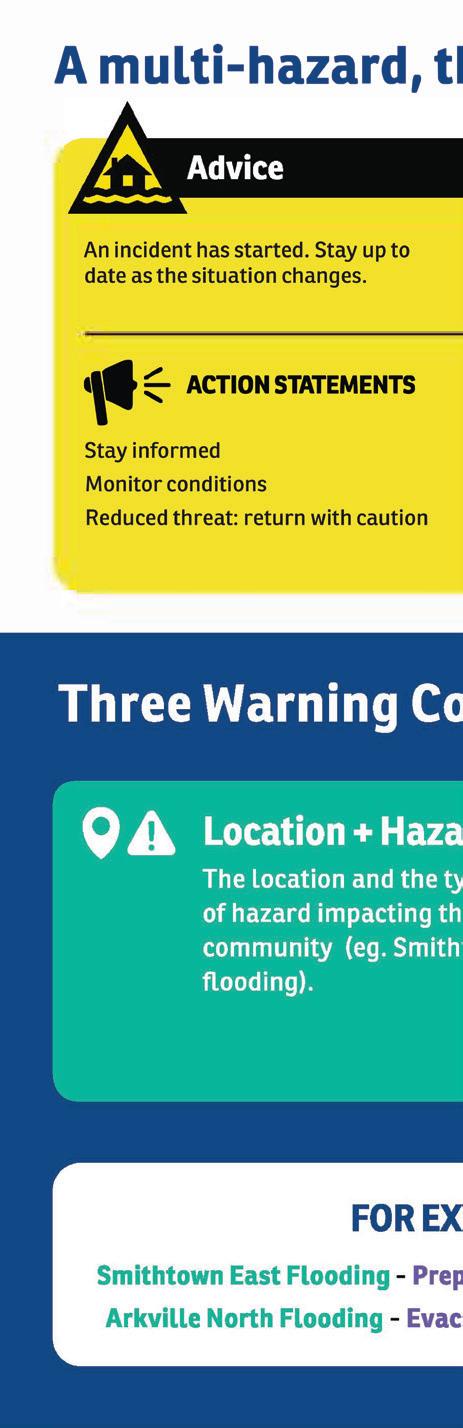
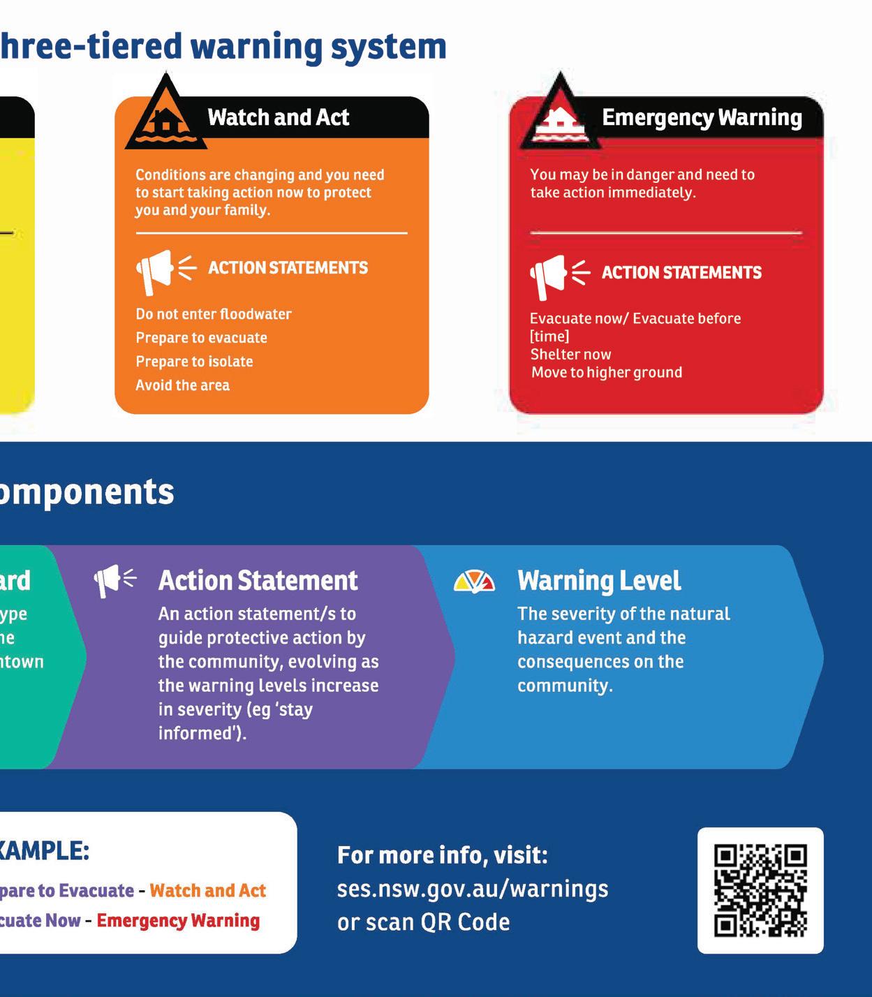
Early warnings enable and empower residents of flood prone communities to take action ahead of severe weather events, saving lives and building stronger, more resilient communities.
The NSW SES is transitioning to the Australian Warning System (AWS) - a national, multi-hazard, three-tiered approach to warning communities likely to be impacted by severe weather events.
The new warnings have clear action statements which will better support communities to take actions and make safe decisions.
The NSW SES is investing in new systems to support communities receive and understand warnings.
The new multi-hazard warning platform HazardWatch www.hazardwatch.gov.au provides a comprehensive view of all NSW SES flood warnings on a map, with many more features coming soon.
• Know your escape route. It could be flooded long before your property is affected, preventing you from leaving.
• If in doubt, leave early.
• The SES does not have enough rescue boats to send to every property. Everyone needs a plan of what to do to keep safe.
Follow flood warnings, alerts and advice, visit www.ses.nsw.gov.au or tune into your local radio station
• Keep up to date with flood warnings and know where you will go if you are asked to evacuate
• Prepare an emergency kit with essentials, medication, drinking water, mosquito repellent, important documents, valuables, a battery-operated radio, a torch, phone chargers and batteries, clothing and personal hygiene items with a waterproof bag or container
• Make a plan for keeping your animals and livestock safe. Know what to take for your animals and how to relocate or transport your animals
• If you are living with a disability, identify a support person or carer in your plan
• Have a list of important numbers ready
• For a personal detailed emergency plan that you can download, email or print, visit www.seshomeemergencyplan.com.au
• Never drive, ride, walk or swim through floodwater
• Share your emergency plan with your family and neighbours
• Listen to your local radio station or go to www.ses.nsw.gov.au for flood warnings, evacuation orders and other information
• Check road closures and traffic conditions: www.livetraffic.com or call 132 701
• Secure objects that are likely to float, place possessions and electrical items on tables or benches, and relocate waste containers or chemicals above flood levels
As our community recovers from the impacts of extreme weather and floods, it's important to know what support and information is available.
To find flood recovery and clean-up advice, including accommodation and financial support, visit www.nsw.gov.au/floods/recovery
Staying safe during flood clean-up: Floodwater and mud can contain garbage, chemicals, debris, sewage and other hazardous contaminants, such as disease-causing bacteria, fungi and viruses. Flooding can also lead to an increase in spiders and snakes. If you are bitten, stay calm and call Triple Zero (000).
Cleaning up debris and waste: Council can help direct residents to dispose of flood-damaged rubbish and other waste. The waste levy can be waived for waste arising as a result of storms and floods subject to a natural disaster declaration. Check Council’s website www.lismore.nsw.gov.au under Households, then Waste for opening hours and whether there are special requirements for disposing of flood-damaged waste. For more advice and information on cleaning your flood affected property, and dealing with chemical waste and hazardous materials, visit www.epa.nsw.gov.au.
Dealing with asbestos in flood-affected areas: Be aware and stay safe around asbestos after emergencies and disasters. Asbestos is hazardous but you can manage it safely. It is found in many parts of homes built before 1990 including walls, ceilings and roofing, or in products such as pipes, electrical conduits, eaves, or backing under vinyl flooring. Visit www.asbestos.nsw.gov.au to find a licensed asbestos assessor, removalist, or accredited testing lab, or call the Asbestos hotline on 1800 272 378.
How to remove asbestos immediately after a flood or storm: Using a licensed asbestos removalist is the best way to remove asbestos, but this may not be possible following a flood or storm. For more information and advice download the fact sheets at www.asbestos.nsw.gov.au.
During a flood, it’s crucial to know where to get the latest up-to-date information and where to go for help if needed.
We suggest, you keep this list in a handy place in case of emergency.
For emergency assistance in floods, call SES on 132 500. For life threatening emergencies. call Triple Zero (000).
The websites below provide up-to-date information during floods.
NSW SES website: www.ses.nsw.gov.au
Disaster Dashboard: https://disaster.lismore.nsw.gov.au
Facebook: NSW SES Lismore City Unit
Facebook: Northern Rivers NSW SES
Facebook: Lismore City Council
Bureau of Meteorology (BOM): www.bom.gov.au
Road Closures: www.livetraffic.com
For businesses: www.smallbusiness.nsw.gov.au
Other numbers and websites for recovery:
Flood support and services, call 13 77 88, or visit www.nsw.gov.au/floods
Council: www.lismore.nsw.gov.au
Facebook: Lismore City Council
Beyond Blue: 1800 512 348
Lifeline: 131 114