TOWARD A SUSTAINABLE FUTURE


SPATIAL SCIENCES INSTITUTE


“I invite you to join our talented and committed students, faculty, staff and alumni as we unlock the power of geospatial data that supports solutions, answers and decisions leading to healthier populations in more sustainable environments.”
John P. Wilson, Professor and Founding Director, Spatial Sciences Institute
SSI master’s students undertake a week-long spatial data acquisition field experience at USC’s research facilities on Catalina Island.
TURNING GEOSPATIAL DATA INTO ACTIONABLE INFORMATION
Since its founding in 2010, the Spatial Sciences Institute has been using the power of spatial thinking and literacy—the ability to connect place, space and time— to help address our most challenging global issues, including those connected with population growth, urbanization, environmental sustainability and human well-being.
Through our innovative research and academic programs, we educate and empower today’s and tomorrow’s spatial problem solvers to deploy spatiotemporal perspectives and insights across every possible discipline and industry. Members of our internationally-recognized faculty contribute to the rapidly-evolving body of geospatial knowledge and technology. From our home base in the USC Dornsife College of Letters, Arts and Sciences, we collaborate with faculty colleagues and students throughout the University of Southern California and with other prestigious institutions around the world on funded research that links SSI faculty and students with decision makers and citizens and combines knowledge with action. We promote the analysis, modeling and visualization of location-based data through interdisciplinary use-inspired and integrated research and teaching.
In the USC Urban Trees Initiative, USC spatial scientists are providing the City of Los Angeles with analyses needed to double the number of shade trees in the most tree-poor areas in the Eastside of Los Angeles to mitigate heat stress and to promote walkability and social networks. The team has built a series of mobile sensors to measure the air quality within a tree canopy. Early findings indicate that individual species of trees may affect air quality differently.

1
We harness geospatial sciences and technologies to foster collaboration, build consensus, reach decisions and take actions that create a sustainable future.
SPATIAL SCIENCES INSTITUTE

Founded July 1, 2010
FY23 REVENUE
INSTRUCTIONAL $11 MILLION
FUNDED PROJECTS AND GIFTS $5 MILLION
TOTAL $16 MILLION
of
BY THE NUMBERS
224 percentage increase in instructional revenue from FY20 to FY23
378 M.S. in Geographic Information Science and Technology (GIST) degrees awarded 2010-2022

7
M.S. GIST students who have won the prestigious UNIGIS International Academic Excellence Prize
688 Student awards and prizes 2010-2022
4,535
Undergraduates taught in SSI general education courses 2010-2022
280
Inducted members of the USC Nu Theta Chapter of Gamma Theta Upsilon, the honorary geography society 2018-2023
2,837 John Wilson’s LinkedIn connections
2
Field biologist Bryna Mills (M.S. GIST ’21) won the 2021 M.S. GIST First Place Thesis Prize, the 2021 Los Angeles Geospatial Summit Esri Student Poster Competition Prize and the 2023 UNIGIS Academic Excellence Second Place Prize for her thesis “An Exploration of the Spatiotemporal Distribution
Snow Crab in the Eastern Bering Sea: 1982-2018.”
“Bryna’s poster stands out among others as she creatively used the space-time cube to visualize and analyze the spatiotemporal data of the snow crab, to understand their abundance and distribution pattern over space and time, and whether climate change has an impact on it.”
Canserina Kurnia, Senior Solution Engineer | Education, Esri
Number of SSI Academic Programs: 19
PROGRAMS IN THE USC DORNSIFE COLLEGE OF LETTERS, ARTS AND SCIENCES


● Minor in GIS and Sustainability Science
● Minor in Human Security and Geospatial Intelligence
● Minor in Spatial Studies
● B.S. in GeoDesign
● B.S. in Global Geodesign
● B.S. in Human Security and Geospatial Intelligence
● Graduate Certificate in Geographic Information Science and Technology
● Graduate Certificate in Geospatial Intelligence
● Graduate Certificate in Geospatial Leadership
● Graduate Certificate in Remote Sensing for Earth Observation
● M.S. in Geographic Information Science and Technology
● M.A. in Global Security Studies
● M.S. in Human Security and Geospatial Intelligence
● M.S. in Spatial Data Science
● M.S. in Spatial Economics and Data Analysis
● Doctoral Graduate Certificate in Spatial Analysis
● Ph.D. in Population, Health and Place
PROGRAMS IN OTHER USC SCHOOLS
● GeoHealth concentration, USC Master of Public Health, Keck School of Medicine of USC
● Geographic Information Systems specialization, USC M.S. in Transportation Systems Management, USC Viterbi School of Engineering
COLLABORATING ORGANIZATIONS INCLUDE
● Addiction Research Center
● American Association of Geographers (AAG)
● Enhancing Neuroimaging Genetics through Meta Analysis (ENIGMA)-Environment Working Group
● Southern California Center for Latino Health (SCCLH)
● Southern California Clinical and Translational Science Institute (SCCTSI)
● Southern California Environmental Health Sciences Center (SCEHSC)
● University Consortium of Geographic Information Science (UCGIS)
● UNIGIS, the worldwide consortium of online graduate GIS programs
● United States Geospatial Intelligence Foundation (USGIF)
● URISA, the Urban and Regional Systems Association
● USC Information Sciences Institute (ISI)
● USC Institute for Creative Technologies (ICT)
● USC Leonard D. Schaeffer Center for Health Policy and Economics
● USC Norris Comprehensive Cancer Center
3
CREATING SUSTAINABLE SOLUTIONS
Reducing Urban Heat with Trees

In partnership with the City of Los Angeles, an SSI-led research team is using advanced mapping technology, air quality measurements and landscape visualizations to develop the most effective tree canopy in neighborhoods around the USC Health Sciences and University Park campuses. The initiative provides decisionmakers with data-driven and community-informed insights into where, how many and what type of new trees will maximize health and equity benefits to residents in tree-poor areas of South and East Los Angeles. The project leadership includes the USC Dornsife Public Exchange and SSI faculty affiliates Esther Margulies, USC School of Architecture, and William Berelson, USC Dornsife Department of Earth Sciences.

SSI student researchers under the direction of John P. Wilson and Beau MacDonald have included Rachel Ablondi, Naman Casas, Eileen Chen, Charles Curtin, Jackson FitzGerald, Jillian Gorman, Erik Huisman, Emma Johnson, Runzi Kang, Carolyn Koh, Joan Lee, Alyssa Ng and Seher Randhawa. The student research teams won the 2021, 2022 and 2023 USC Schwarzenegger Institute for State and Global Policy first prize award and the 2022 and 2023 USC Sustainability second prize award.
Achieving Climate Neutrality at USC
2025: the year by which USC President Carol Folt intends the university to be climate neutral. In support of the university’s Assignment: Earth initiative, SSI faculty, staff and students with the USC Office of Sustainability have launched the USC Sustainability Data Hub for members of the USC community to engage with sustainability data and build out sustainability solutions. Elisabeth Sedano, assistant professor (teaching) of spatial sciences, and Laura C. Loyola, assistant professor (teaching) of spatial sciences, with John P. Wilson and Beau MacDonald, lead undergraduate student researchers in expanding the data hub that SSI hosts. The 2021-2022 student team of Rachel Ablondi, Nicole Carrera, Anna Curtis, Kelley Green, Carolyn Koh and Jessica Zhang won the 2022 USC Provost’s Undergraduate Research Symposium Digital Media first prize and 2022 USC Sustainability first prize award.
4
Asgmt Earth USC
Planning for a Livable Region

The Southern California Association of Governments (SCAG), the largest metropolitan planning organization in the nation, is responsible for developing long-range transportation plans and sustainable community strategies for Imperial, Los Angeles, Orange, Riverside, San Bernardino and Ventura counties. Since 2020, SSI student researchers have been contributing to SCAG’s GIS-based projects, providing spatial database management, geoprocessing, data analysis and mapping.
Protecting a Fragile Environment
Jason T. Knowles, adjunct associate professor of the practice and CEO/founder of GeoAcuity, joins SSI students every semester at the USC Wrigley Marine Science Center (WMSC) near Two Harbors, Catalina Island, to demonstrate novel unmanned aerial systems capabilities and to support specialty data collections, such as kelp mapping and underwater bathymetry. Since 2017 SSI researchers have been assembling a comprehensive data collection of the WMSC campus. Maintained in the Open GeoData Hub by the USC Institute for Creative Technologies, SSI and GeoAcuity, these free resources show the capabilities of cutting-edge technologies. They document environmental impacts on the island and how its ecologies are changing over time.


5
L-R, first row: Mingyu Zong, M.S. Spatial Data Science student; Xiaoxiao Li, Ph.D., Regional Planning Specialist; Jung Seo, Program Manager, GIS; Tom Minh Vo, Program Manager, Local Info Services; Jonah Pellecchia, Associate Regional Planner
L-R, second row: Kelly Kwok, B.S. GeoDesign student; Frank Wen, Ph.D., Manager of Planning Strategy; Sandeep Kahlon, M.S. Spatial Data Science student; Hsi-Hwa Hu, Ph.D., Manager of Modeling and Forecasting
“
The Spatial Sciences Institute does a great job in preparing their students to step into professional work. We give them some background and they take off. They have produced sophisticated solutions that we could not have imagined.”
Tom Minh Vo, Program Manager, Local Info Services, SCAG
PROMOTING HUMAN WELL-BEING Population, Health and Place

Optimizing Food Security
The lack of timely, integrated and accessible information about fluctuations in the food system and the risks these pose to food and nutrition security has stymied the ability to improve food resilience.
Advancing Precision Medicine

When it comes to a baby’s health, the air its mother breathes makes a critical difference. Rima Habre and other SSI researchers have found that Hispanic women living in neighborhoods with high levels of air pollution early in their pregnancies have babies with lower birth weights. Habre, associate professor of population and public health sciences and spatial sciences, is a lead investigator with the USC Maternal Developmental Risks from Environmental and Social Stressors (MADRES) Center for Environmental Health Disparities. With funding from the National Institute of Environmental Health Sciences, Habre’s team is using innovative geospatial technology to capture personal exposures and genetic makeup to formulate individual analyses of disease risk and aid prevention efforts, expanding the boundaries of precision medicine. Population, Health and Place Ph.D. alumni Yan Xu and Li Yi contributed to this study.
Funded with a $2-million National Science Foundation grant, interdisciplinary USC scientists led by Kayla de la Haye, associate professor of population and public health sciences and spatial sciences; Wändi Bruine de Bruin, provost professor of public policy, psychology and behavioral science; and John P. Wilson, are working with Los Angeles County leaders, community organizations and private partners to build a comprehensive data portal that will give stakeholders the ability to understand the dynamics of a county food system, enabling them to flag the issues most in need of intervention. The portal will serve as a prototype for cities and counties across the U.S. to increase food system resilience. SSI researchers include Population, Health and Place Ph.D. candidates Leo Lerner, Michelle Livings and Mengya Xu, M.S. Spatial Data Sciences students Dominic Borelli and TianLiang Zhao and M.S. Geographic Information Science and Technology student Matthew Bauer
6
1 in 4 in L.A. County experienced food insecurity in 2021-2022
Improving Health Equity


The World Health Organization considers geographic access to pharmacies to be a key determinant of access to essential medicine access. And yet, proximity to pharmacy services is generally not factored into the analysis of health care accessibility. One-third of neighborhoods in the largest U.S. cities—including Los Angeles—are a pharmacy desert, with Black or Hispanic/Latino communities being the most impacted neighborhoods. SSI faculty affiliate Dima M. Qato, associate professor of pharmacy, is leading an initiative to generate real-time information with spatial computing and analysis capabilities for national, state and local policy officials, health care academics, industry professionals and others. Qato, Robert O. Vos, associate professor (teaching) of spatial sciences, and Taylor Robinson (M.S. GIST ’22), in collaboration with others in the Program on Medicines and Public Health, have developed an interactive mapping tool that shows the location of every pharmacy in the United States and pharmacy shortage areas. Their goal is to support policymakers and other leaders in developing strategies to improve pharmacy access in underserved communities with historically marginalized populations on a national scale. Their collaborators include the USC Leonard D. Schaeffer Center for Health Policy and Economics and the National Community Pharmacists Association, which represents independent pharmacies around the country.

Jonathan M. Tan, assistant professor of clinical anesthesiology and spatial sciences, is spatially analyzing economic and environmental data with individual pediatric patient electronic health records to provide a deeper understanding of the social determinants of health risk factors that patients experience. Tan and undergraduate researcher Alicia Adiwidjaja determined that patients who came from census tracts of high social vulnerability were more likely to miss or cancel telehealth appointments and opt out of caudal epidural injections during general anesthesia. Their findings are foundational for developing intervention strategies that address health care inequities; their novel methodology of using geospatial analysis with patient population data linkage techniques has application beyond the pediatric pain unit.

7
Dima M. Qato (left) and Robert Vos (right) review their map application that shows how far historically marginalized populations must travel to their nearest pharmacy to fill their prescriptions.
At the 2022 Esri User Conference Map Gallery, Alicia Adiwidjaja (right) discussed the results of her research with Leilei Duan, lecturer of spatial sciences (left).
“ This research opportunity was so special because I was using GIS to change lives.”
Alicia Adiwidjaja (B.S. GeoDesign ’22 , summa cum laude)
FOSTERING STABLE AND SAFE COMMUNITIES Human Security and Geospatial Intelligence
Preparing the GEOINT Workforce


Our undergraduate and master’s programs in human security and geospatial intelligence (HSGI) provide workforce-focused leadership, management and technical knowledge that gives graduates the skills and expertise to lead and manage new initiatives in the rapidly shifting landscape of GEOINT applications, data collection systems, analytic methods and mission support.
The United States Geospatial Intelligence Foundation (USGIF) has accredited all of SSI’s academic HSGI programs. This accreditation indicates that our HSGI programs comply with the highest standards for GEOINT curriculum, faculty expertise, novel research approaches and availability of adequate resources for state-of-the-art teaching and learning.

FROM 2015 TO 2022:
● 125+ students have graduated from SSI HSGI academic programs
● 80+ of these have been active duty personnel, Department of Defense (DoD) support agency personnel or veterans
● 75+ of these transitioned into intelligence, security or public safety work at the national, state and local levels
● 20+ graduate certificate and masters students completed DoD-focused projects and theses while at USC

8
“I am extremely grateful for all the opportunities I’ve had to learn and develop, all thanks to the resources at SSI.”
Jong Su Kim (USC ROTC Air Force Cadet; B.A. International Relations ’ 19; M.S. Human Security and Geospatial Intelligence ’20), Information Integration Officer, Second Lieutenant, U.S. Air Force
Christy Monaco, USGIF vice president of programs, presents John P. Wilson with the accreditation certificate for SSI’s HSGI programs.
Even before USC became a university partner of the U.S. Space Force, the newest division of the Armed Forces, the Spatial Sciences Institute has been placing graduates in roles that support national security objectives in the space domain. Examples of SSI graduates serving in the U.S. Space Force include Rebecca Bosworth (M.S. Geographic Information Science and Technology ’23), Jillian Combs (M.S. Human Security and Geospatial Intelligence ’21) and Ben Miralia (M.S. Human Security and Geospatial Intelligence ’20). SSI faculty are part of USC’s new Center for Research in Space Technologies (CREST).

Selected SSI Student Recipients of USGIF Scholarships and Awards
● Courtney Fassett: 2017 Graduating High School Senior Scholarship
● Richard Windisch: 2018 Golden Ticket (young professional award)
● Kevin Mercy: 2019 Golden Ticket; 2020 RGi Scholarship for Geospatial and Engineering
● Elin Henningsson: 2020 Golden Ticket

● Jong Su Kim: 2020 Graduate Scholarship
● Mia Poynor: 2020 Most Promising Female GEOINTer Award recipient
● Tristan Pekron: 2022 Ken Miller Scholarship for Advanced Remote Sensing Applications
● Jacob Spear: 2022 Graduate Scholarship
Developing Global Security Leaders
The tragic and troubling events taking place around the world are unfortunate evidence that global security is under threat. In Fall 2022, SSI launched the M.A. in Global Security Studies Program to prepare professionals for leadership roles in global governance and security. Working with faculty from SSI, the USC Dornsife Department of Political Science and International Relations, the USC Shoah Foundation and the USC Wrigley Institute for Environment and Sustainability, students develop a unique combination of competencies in the acquisition, analysis and interpretation of testimony and geospatial data.
Diana Ter-Ghazaryan, associate professor (teaching) of spatial sciences, specializes in the transformation of post-Soviet and Armenian urban landscapes, the digital humanities and use of geospatial technologies to preserve cultural heritage. Her GEOINT background includes leading a geospatial data curation team responsible for a data hub of resources supporting security of Latin American and Caribbean partner nations of U.S. Southern Command.

9
Top: Steven L. Lamy, professor emeritus of international relations and spatial sciences, chairs the Global Security Studies Program Board.
Bottom: Diana Ter-Ghazaryan has a Ph.D. in international relations and geography.
Lt. Gen. Michael A. Guetlein looks on as USC President Carol L. Folt signs the agreement to have USC join the U.S. Space Force’s University Partnership Program.
CREATING RESILIENT ENVIRONMENTS Geodesign


Since 2014, the Spatial Sciences Institute has offered USC undergraduates an opportunity to experience and apply geodesign principles and practices in intensive comparative international contexts. Under the leadership of Darren M. Ruddell, associate professor (teaching) of spatial sciences, and Laura C. Loyola, assistant professor (teaching) of spatial sciences, students In the summer course SSCI 350: International Geodesign have worked with local governments, community members and urban design

practioners to create plans for a mixed-use green zone in the Amstelland region of the Netherlands, a renewable energy program for residents in Amsterdam Noord, and an urban renewal strategy that both increases density and green space in the Schallmoos district of Salzburg, Austria. In the summer of 2023, Guoping Huang, associate professor (teaching) of spatial sciences, has joined Professors Ruddell and Loyola in expanding future SSCI 350 locations to China, Africa and South America.
Cass Kalinski (M.S. GIST ’ 18) won the 2019 UNIGIS Academic Excellence Prize and the 2020 Esri Education Development Center Student of the Year Award for his thesis “Building Better Species Distribution Models with Machine Learning: Assessing the Role of Covariate Scale and Tuning in Maxent Models.” Using the bristlecone pine (Pinus longaeva) as his example species, Kalinski developed a novel approach that has contributed to the advancement of species distribution models currently used by a diverse community of biologists, land and wildfire managers, environmental scientists and others working to protect endangered species.
Guoping Huang and Robert O. Vos are 2023 USC iPodia Faculty Fellows, selected by the USC Office of the Vice Provost of Academic Programs, to develop new pedagogical approaches to offer SSI’s global geodesign curriculum and experiential learning opportunities to students and faculty at partner universities around the world.

10
In recognition for her perfect 4.0 GPA, Jasmine Siyu Wu (B.S. GeoDesign ’22 , Minor in Architecture, summa cum laude) received the 2021 USC Emma Josephine Bradley Bovard Award, given to graduating senior women who have attained the highest grade point average and contributed the most extracurricular service to the university. Jasmine was also recognized as a USC Discovery Scholar, a distinction that recognizes graduating seniors who have excelled academically while making a meaningful contribution to their field of study through exceptional new scholarship. She pursued research interests in urban informatics, spatial data science, environmental justice, and sustainable design and transportation planning.

She co-authored the article “Locations of Licensed and Unlicensed Cannabis Retailers in California: A Threat to Health Equity?,” published in Preventive Medicine Reports (September 2020), with co-authors Robert O. Vos and members of the faculty with the Keck School of Medicine of USC. Her internship experiences included working as a GIS/Data Analyst for the City of Los Angeles Department of Transportation, providing analytical support for Mayor Eric Garcetti’s “Vision Zero” program, the datadriven initiative to eliminate traffic fatalities in Los Angeles by 2025
Jasmine is completing a Master of City Planning at the University of Pennsylvania.
Alexa Weintraub (B.S. GeoDesign ’22 , magna cum laude) was one of 10 finalists in the student category of the 2020 ArcGIS StoryMaps Competition for Sustainable Development Goals (SDGs), sponsored by GIS technology company Esri and the United Nations Sustainable Development Solutions Network to increase awareness of the SDGs and to foster action towards their achievement.
Alexa’s StoryMap “Eating on the Streets: A New Pandemic Lifestyle” focuses on SDG 8: Decent Work and Economic Growth and the impact of outdoor dining in New York City as an adaptation method due to COVID-19. Alexa posits that altering the layout of one of the world’s busiest cities by adding outdoor dining to restaurants will produce a mix of positive and negative impacts, including consequences that will play out for years to come. She produced her StoryMap as the final project in SSI’s course SSCI 402 : Geospatial Technology Management for Sustainability Science taught by Leilei Duan

11
“
During my time with the Spatial Sciences Institute, GIS has laid a solid foundation for me to do good for people in the city and beyond.”
FINDING ANSWERS IN BIG DATA
Spatial Data Science
Spatial Economics and Data Analysis
In his book, Spatial Data Science (Esri Press, 2023), John P. Wilson outlines why and how spatial scientists and data scientists complement one another in their thought processes and methods. He calls for scientists across academic
disciplines and practioners in diverse application domains to adopt and utilize the latest advances in computing, new geospatial data streams and the latest spatial methods.

12
THEORY PLACE SPACE + TIME SPATIOTEMPORAL INFORMATION PRACTICE TECHNOLOGY
Yi Qi (center) shows his faculty colleague Leilei Duan (left) and student Meihong Dong (M.S. Spatial Data Science ’23)(right) two of the drones that he uses to teach spatial data acquisition and remote sensing.
“
The focus on place, space, time and spatiotemporal information and the complementary roles of theory, practice and technology in the spatial sciences offer hope that we can achieve the United Nations’ Sustainable Development Goals before the world as we know it is irreversibly changed.”
John P. Wilson
HARRISON KNAPP
(B.S. GeoDesign and B.A. Earth Sciences ’20, cum laude; M.S. Spatial Data Science ’22), Remote Sensing Scientist, The Aerospace Corporation, El Segundo, CA
“Courses in spatial design and thinking led to others in GIS programming and customization in Python, data analysis for the earth sciences, and advanced cartography. I ventured outside the classroom into research and internships that allowed me to work with all kinds of geospatial datasets: satellite imagery and oceanographic data at the NASA Jet Propulsion Lab, composite snow data products and climate indices at the NOAA Pacific Marine Environmental Lab, and light pollution metrics from both remote and in situ sensors at the USC Spatial Sciences Institute. With an understanding of the nuances of data architecture, the power of machine learning, and experience working with geospatial big data, I am motivated to continue developing as a data scientist.”
AMANDA RAGO
(B.S., Applied and Computational Mathematics ’21; M.S. Spatial Economics and Data Analysis ’23)


“ What drew me most to the M.S. Spatial Economics and Data Analysis program was the ability to dive into data analytics with an economic frame of reference that is both holistic and scientific. After I graduate in May 2023, I’ll be joining Deloitte’s Government and Public Service division. This career path will use my SEDA degree as multiple projects will leverage spatial software and will have a heavy focus on data analytics.”
CHUN-LUN KAO
(Bachelor of Business Administration with Honors, Management Science and Finance, National Dong Hwa University ’18; M.S. Spatial Economics and Data Analysis ’22), Student, Ph.D. Program in Geographic Information Science, Arizona State University
“ The training I received at the USC Spatial Sciences Institute prepared me with strong spatial modeling skills and the ability to independently perform complex spatial analyses with diverse expertise. The M.S. SEDA program provided me with extensive GIS training such as suitability analysis, accessibility analysis, spatial regression modeling and agent-based models. I also was able to take economics courses and familiarize myself with regression models to analyze business activities. As a Ph.D. student with Dr. Stewart Fotheringham, I am exploring possible adjustments to current spatial models.”
OLIVIA V. LEWIS
(B.A. Economics ’21, cum laude; M.S. Spatial Economics and Data Analysis ’22), Associate Analyst, NERA Economic Consulting, San Francisco, CA


“
The M.S. SEDA program was a perfect continuation of my undergraduate degree and allowed me to take challenging courses related to economics in a spatial capacity. All of the concrete tools and skills I developed throughout the program are directly applicable to my career working in antitrust litigation and mergers and acquisitions. I use my spatial analysis knowledge to understand the catchment areas of businesses and whether their movement can be considered anti-competitive.”
13
IN THE COMMUNITY
Since 2018, USC students, faculty and staff have teamed up with UCLA counterparts and other universities and organizations around the world to conduct a mapathon during Earth Week that contributes entries in OpenStreetMap (OSM) humanitarian projects with an environmental and sustainability focus. By rallying school spirit to work together, the annual mapathon consistently ranks as one of the OSM’s largest mapathon events.


In celebration of the annual GIS Day, the Spatial Sciences Institute student organization SC Mappers leads student volunteers in mapping projects on the University Park campus. For the 2022 GIS Day project, student volunteers collected data on the location and condition of waste bins on campus for the USC Sustainability Data Hub. This information supports the analysis of the usage and distribution of waste bins to improve bin access and to promote proper recycling/ composting methods.
Every February we present the annual one-day Los Angeles Geospatial Summit, a unique event that brings together industry leaders, subject matter experts, students, young professionals and scholars in a Southland geospatial community of practice.
14
“
The mapathon was such a fun and rewarding experience! Being able to team up with other students to make a difference in humanitarian mapping efforts is an amazing opportunity.”
Madeline Rouse (B.A. Linguistics and Cognitive Science, Minors in Choreography for Stage and Screen and Human Security and Geospatial Intelligence ’22 , summa cum laude; M.S. Human Security and Geospatial Intelligence ’23)
SSI Managing Director Susan H. Kamei is recognized today as one of our country’s most prominent and visible scholars on the Japanese American incarceration during World War II and one whose work has significantly influenced the study of political, social and Asian American history. Her book


When Can We Go Back to America? Voices of Japanese American Incarceration during World War II (Simon & Schuster 2021) has received critical acclaim for its riveting, meticulously researched and comprehensive historical narrative of this tragic episode in our nation’s history. She has appeared in broadcasts by NPR, BBC Studios, France 24, NBC, and C-SPAN, and her op-ed pieces and other articles have been published in the Los Angeles Times, The Conversation and Discover Nikkei. Kamei created and teaches a popular USC undergraduate history course on the incarceration and its constitutional and social implications today, the first of its kind to take a comprehensive and interdisciplinary approach to this complex subject. In recognition of her scholarship and contributions to USC, she received a 2022 USC Phi Kappa Phi Faculty Recognition Award, the 2022 USC Dornsife Communicator of the Year Award for the Humanities and the USC Undergraduate Student Government 2018 Community Achievement Award.

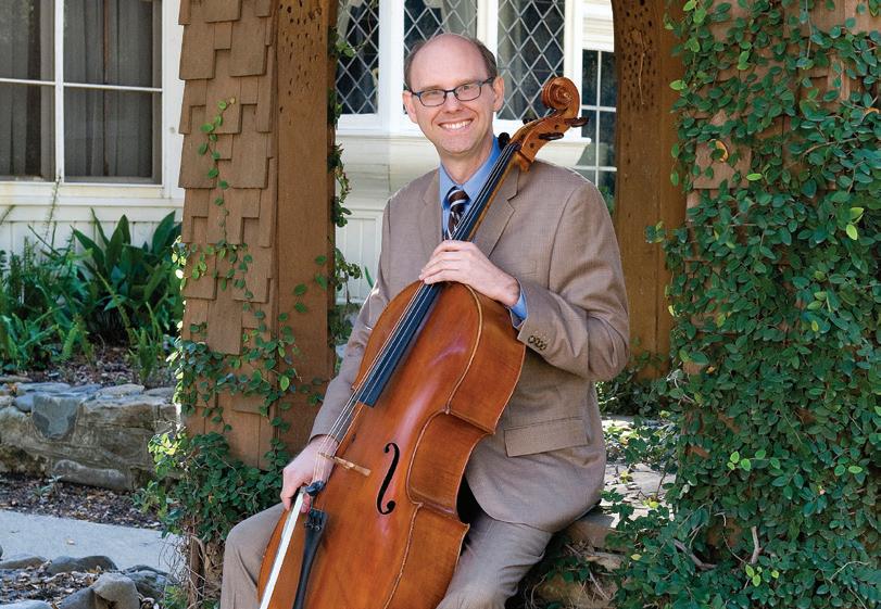
Robert O. Vos could be called a triple threat. In addition to his distinguished career as a geospatial educator and researcher, he is a world-class cellist who has been performing with the Orange County-based Pacific Symphony since 2003. Vos, who studied cello at the USC Thornton School of Music, has USC M.A. and Ph.D. degrees in political science and a USC interdisciplinary B.A. in the study of the city. He provides inspiration to students and those who seek to harmonize numerous passions and pursue excellence in multiple endeavors.
15
“
The Spatial Science Institute’s annual Geospatial Summit provides us with an important opportunity to recruit the best GIS talent to join our team.”
Joel Farrier, West US Strategic Growth Leader and Regional Environment Manager, Burns & McDonnell
Leadership
John P. Wilson
Founding Director
Susan H. Kamei
Managing Director
Darren M. Ruddell Director of Graduate Studies
Laura C. Loyola (until January 7, 2024)
Diana Ter-Ghazaryan (as of January 8, 2024) Director of Undergraduate Studies
Staff
Dairon Caro Academic Program Administrator
Timothy Lu Distance Education Operations Specialist
Beau MacDonald GIS Project Administrator
Myron Medalla Systems Administrator III
Monica Pan Academic Programs Director
Stephanie N. Tran
Senior Analyst, Budget Management
Faculty
Leilei Duan
Lecturer of Spatial Sciences
Guoping Huang
Associate Professor (Teaching) of Spatial Sciences
Laura C. Loyola
Assistant Professor (Teaching) of Spatial Sciences
Yi Qi
Associate Professor (Teaching) of Spatial Sciences
Darren M. Ruddell
Associate Professor (Teaching) of Spatial Sciences
Elisabeth Sedano
Assistant Professor (Teaching) of Spatial Sciences
Jennifer N. Swift
Associate Professor (Teaching) of Spatial Sciences
Diana Ter-Ghazaryan
Associate Professor (Teaching) of Spatial Sciences
Robert O. Vos
Associate Professor (Teaching) of Spatial Sciences
John P. Wilson
Professor of Spatial Sciences, Sociology, Architecture, Civil and Environmental Engineering, Computer Science and Population and Public Health Sciences
An-Min Wu
Assistant Professor (Teaching) of Spatial Sciences
Affiliated, Adjunct and Emeriti Faculty
Hoda Abdel Magid
Assistant Professor of Population and Public Health Sciences and Spatial Sciencews
Jennifer A. Ailshire
Associate Professor of Gerontology, Sociology and Spatial Sciences
François Bar Professor of Communication and Spatial Sciences
William M. Berelson Professor of Earth Sciences, Environmental Studies and Spatial Sciences
Marlon G. Boarnet
Professor of Public Policy and Spatial Sciences
Geoff Boeing
Assistant Professor of Urban Planning and Spatial Analysis and Spatial Sciences
Myles G. Cockburn
Professor of Population and Public Health Sciences, Dermatology and Spatial Sciences
Elizabeth Currid-Halkett
James Irvine Chair in Urban and Regional Planning and Professor of Public Policy and Spatial Sciences
Kayla de la Haye
Associate Professor of Population and Public Health Sciences and Spatial Sciences
Maged M. Dessouky
Professor of Industrial and Systems Engineering and Spatial Sciences
William F. Deverell Professor of History, Environmental Studies and Spatial Sciences
Lynn Swartz Dodd
Professor of the Practice of Religion and Spatial Sciences
Philip Ethington
Professor of History, Political Science and Spatial Sciences
Laura Ferguson
Associate Professor of Population and Public Health Sciences and Spatial Sciences
Brian Finch
Professor (Research) of Sociology and Spatial Sciences
Steven D. Fleming
Adjunct Professor of the Practice of Spatial Sciences
Yolanda Gil
Research Professor of Computer Science and Spatial Sciences
Sophia Gruskin
Professor of Population and Public Health Sciences, Law and Spatial Sciences
Rima Habre
Associate Professor of Population and Public Health Sciences and Spatial Sciences
Daniel A. Hackman
Associate Professor of Social Work and Spatial Sciences
Jill Johnston
Associate Professor of Population and Public Health Science and Spatial Sciences
Matthew E. Kahn
Provost Professor of Economics and Spatial Sciences
Karen K. Kemp
Professor Emerita of the Practice of Spatial Sciences
Jason T. Knowles
Adjunct Associate Professor of the Practice of Spatial Sciences
Craig A. Knoblock
Research Professor of Computer Science and Spatial Sciences
Lon Kurashige
Professor of History and Spatial Sciences
Steven L. Lamy
Professor Emeritus of International Relations and Spatial Sciences
Lihua Liu
Associate Professor of Population and Public Health Sciences and Spatial Sciences
Esther Margulies
Associate Professor of the Practice of Landscape Architecture and Spatial Sciences
Ryan McAlinden
Adjunct Assistant Professor of the Practice of Spatial Sciences
Rob S. McConnell
Professor of Population and Public Health Sciences and Spatial Sciences
Paulina Oliva
Associate Professor of Economics and Spatial Sciences
Michael Orosz
Associate Research Professor of Civil and Environmental Engin eering and Spatial Sciences
16
Spatial Sciences Institute students, alumni, faculty, staff, corporate partners and research collaborators gathered at the 2022 Los Angeles Geospatial Summit.

Ann Owens
Professor of Sociology and Spatial Sciences
Nathan Perl-Rosenthal
Associate Professor of History and Spatial Sciences
Dima M. Qato
Associate Professor of Pharmacology and Spatial Sciences
Alexander Robinson
Associate Professor of Architecture and Spatial Sciences
Kelly Sanders
Associate Professor of Civil and Environmental Engineering and Spatial Sciences
Jefferey M. Sellers Professor of Political Science, Public Policy and Spatial Sciences
Cyrus Shahabi
Helen N. and Emmett H. Jones Professor in Engineering and Professor of Computer Science, Electrical Engineering and Spatial Sciences
Emily Smith-Greenaway
Associate Professor of Sociology and Spatial Sciences
Lucio Soibelman
Fred Champion Estate Chair in Engineering est. 1967 and Professor of Civil and Environmental Engineering and Spatial Sciences
Jonathan Tan
Assistant Professor of Anesthesiology, Critical Care Medicine and Spatial Sciences
Gregory F. Treverton
Professor of the Practice of Political Science and International Relations and Spatial Sciences
Editorial direction: Susan H. Kamei
Creative design: ETCH Creative
Photo and Image Credits:
INSIDE FRONT COVER
Laura C. Loyola
PAGE 1
USC Urban Trees Initiative
PAGE 2
Bryna Mills
PAGE 3 [TOP LEFT]
Susan H. Kamei
PAGE 3 [BOTTOM RIGHT]
Anne Marie Maltes
PAGE 4 [TOP]
USC Urban Trees Initiative
PAGE 4 [BOTTOM]
Susan H. Kamei
PAGE 5 [TOP LEFT]
Susan H. Kamei
PAGE 5 [BOTTOM RIGHT]
Laura C. Loyola
PAGE 6 [TOP LEFT]
John Davis
PAGE 6 [BOTTOM RIGHT]
Mengya Xu
PAGE 7 [LEFT]
Susan H. Kamei
PAGE 7 [RIGHT]
Dairon Caro
PAGE 8 [TOP LEFT]
Susan H. Kamei
PAGE 8 [BOTTOM RIGHT]
U.S. Air Force/Jong Su Kim
PAGE 9 [TOP]
University of Southern California/ Steve Cohn
PAGE 9 [MIDDLE]
Mike Glier
PAGE 9 [BOTTOM]
Susan H. Kamei
PAGE 10 [TOP]
Laura C. Loyola
PAGE 10 [BOTTOM]
Cass Kalinski
PAGE 11 [TOP]
Jasmine Siyu Wu
PAGE 11 [BOTTOM]
Ben Hon
PAGE 12 [TOP]
Joe Gaylor
PAGE 12 [BOTTOM]
Esri Press
PAGE 12 [TOP TO BOTTOM]
Harrison Knapp
Amanda Rago
Chun-Lun Kao
Olivia V. Lewis
PAGE 14 [TOP]
Laura C. Loyola
PAGE 14 [LEFT]
Susan H. Kamei
PAGE 14 [BOTTOM RIGHT]
Timothy Lu
PAGE 15 [TOP]
Timothy Lu
PAGE 15 [MIDDLE LEFT]
Greg Stadnyk
PAGE 15 [MIDDLE RIGHT]
Rebecca Little
PAGE 15 [BOTTOM]
Robert O. Vos
PAGE 17
Timothy Lu
17
Spatial Sciences Institute
3616 Trousdale Parkway, AHF B55
Los Angeles, California 90089-0374
213.740.5910
spatialsciences@dornsife.usc.edu
spatial.usc.edu
USC Spatial Sciences Institute
twitter.com/USC_SSI
USC Spatial Sciences Institute
