URBAN PORTFOLIO
Lancelot Comrie
Professional Works
01
Academic Works Table
Climate Resilience Neighborhood Strategies
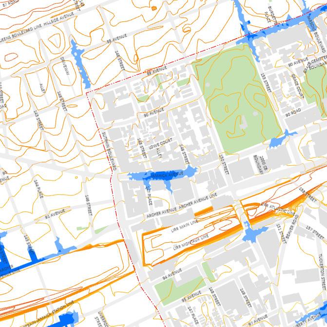
Jamaica, Queens
Joint Venture between Cornell University and MOCEJ | 2023
02
Waterscapes: Forming Community in Fi Di
Financial District, New York
Planning Studio | MRP | 2023
03
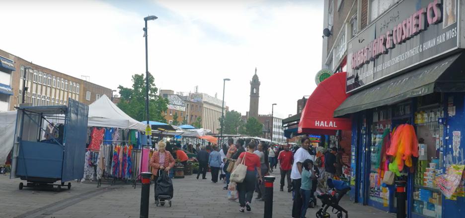
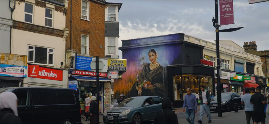
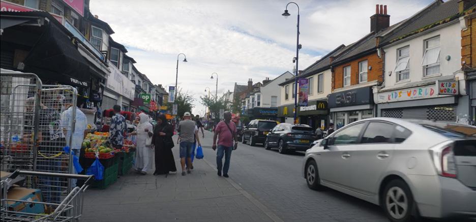
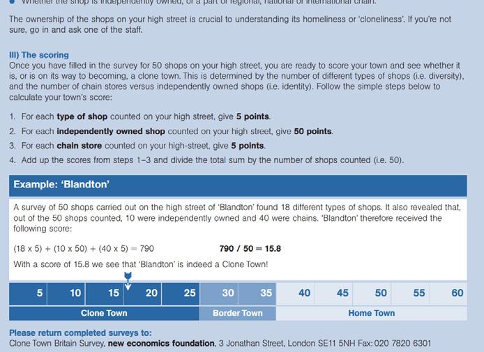
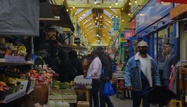
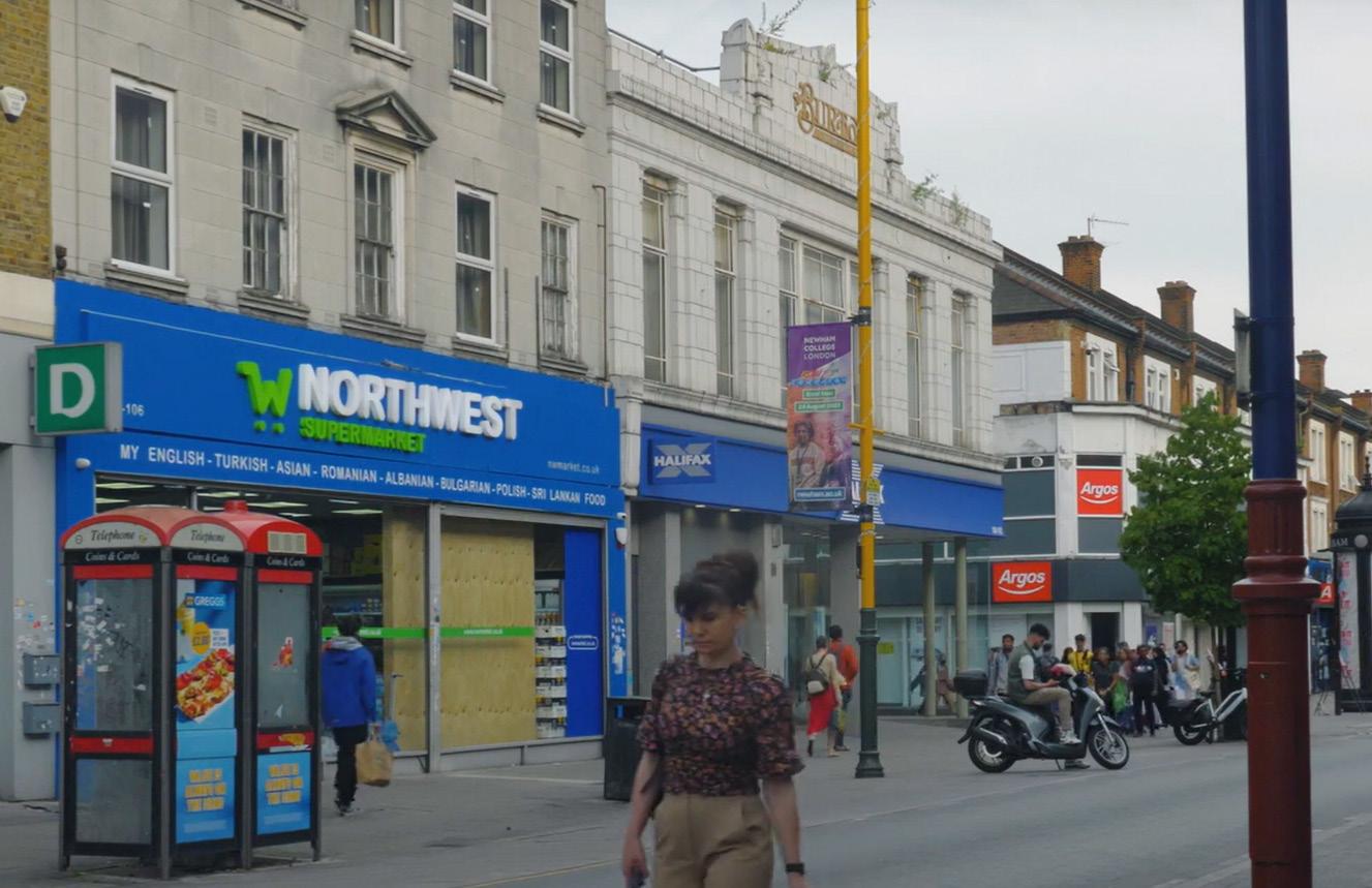
Understanding Sustainability in Clone Town Britain
London, United Kingdom
Final Year Dissertation | MRP | 2023
04
Axi Corridor: Reimagining Woolwich
Woolwich, London
Planning Studio | MRP | 2022
of Contents
01 Climate Resilience Neighborhood Strategies
Proect Type: Joint Venture
Subject: Climate Resilience
Location: Jamaica, Queens
Group Members:
Evelyn Escoboza (Urban Planner)
Wendy Bae (Landscape Architect)
Lancelot Comrie (Urban Planner)
Year: 2023-2024
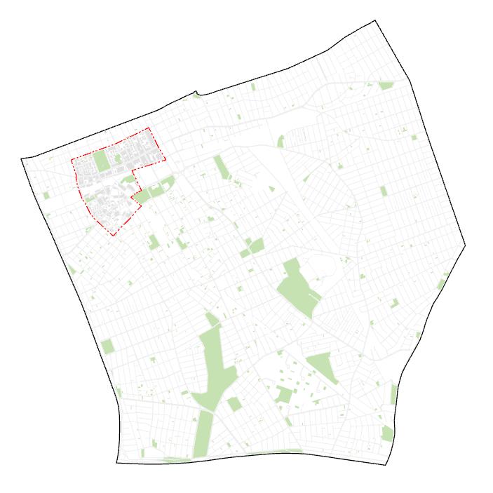
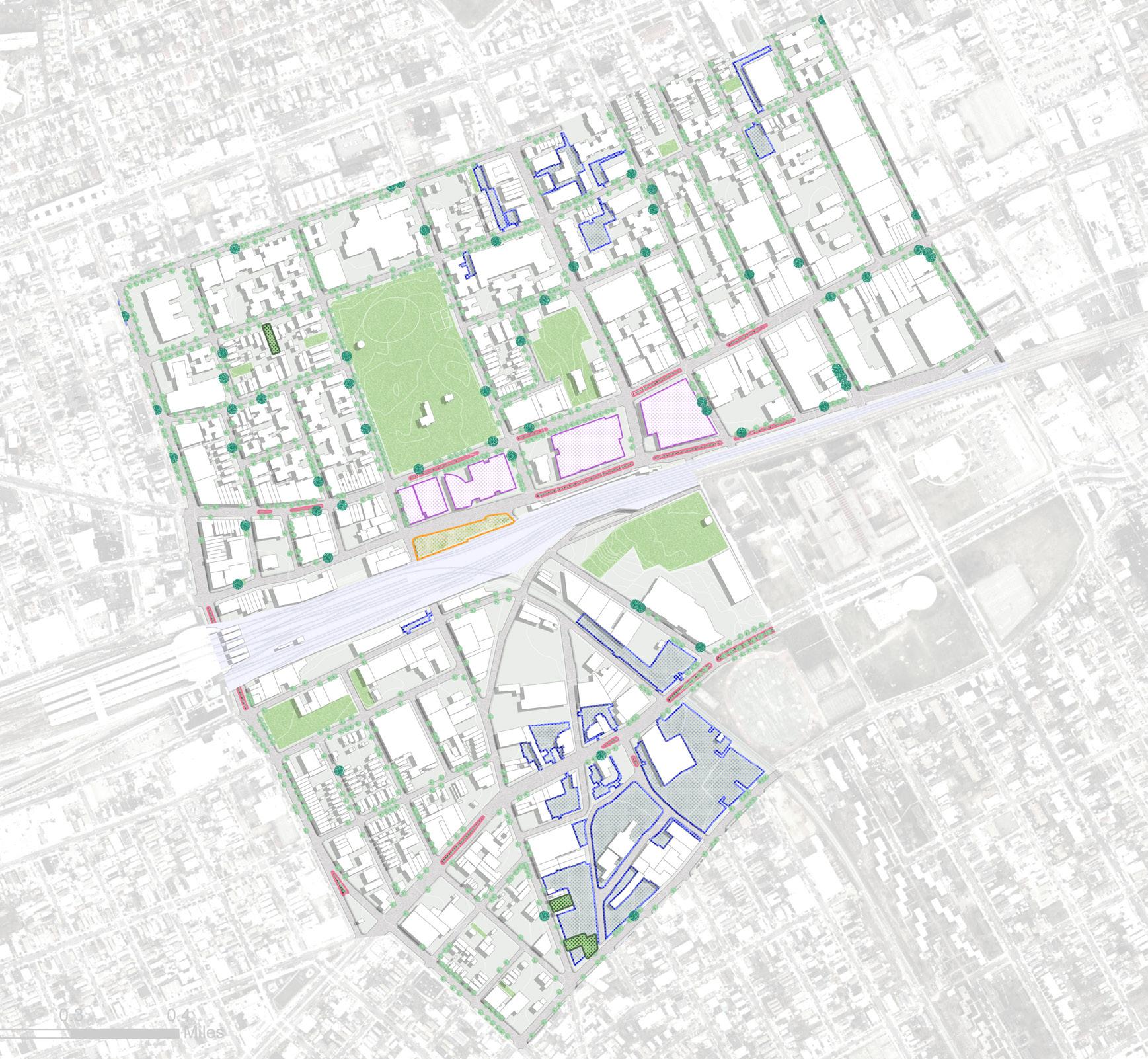
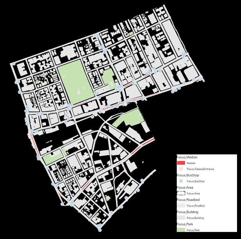
Context
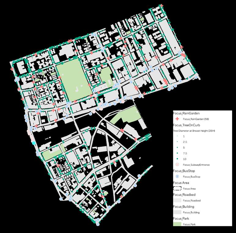
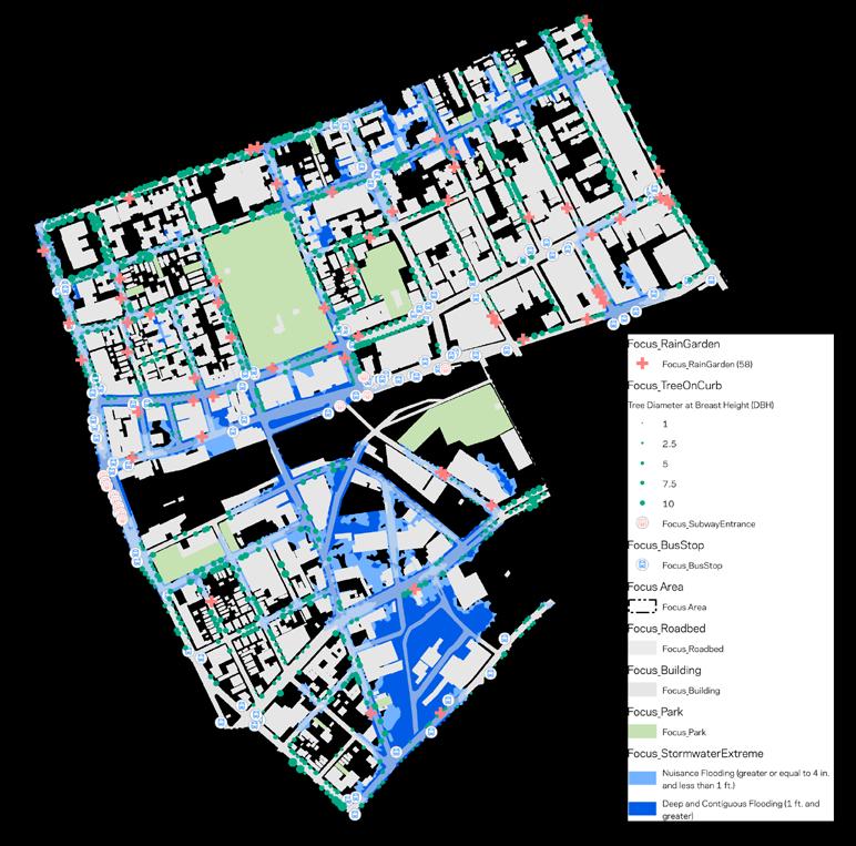
FOCUS AREA: OPPORTUNITIES & CONSTRAINTS
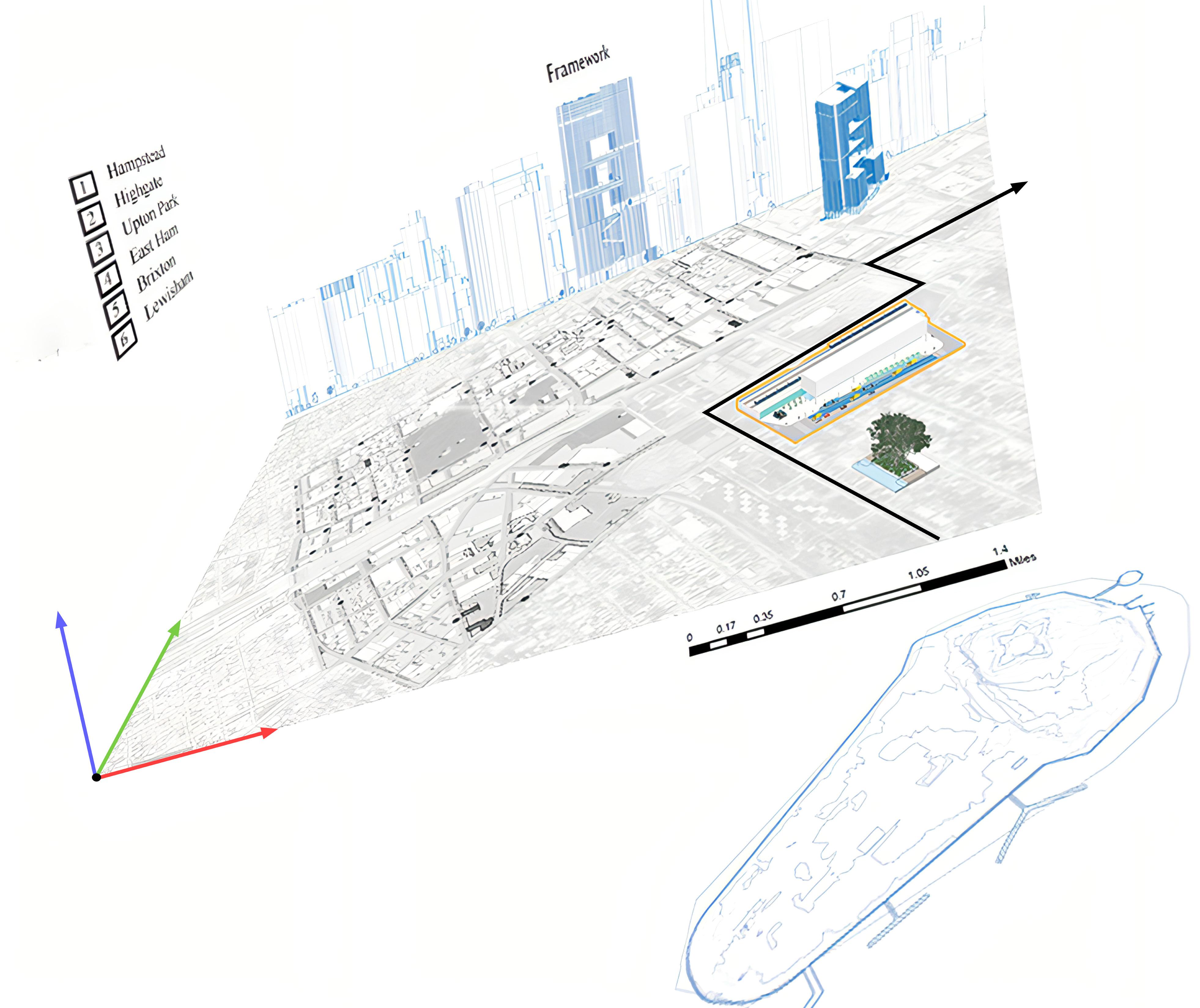
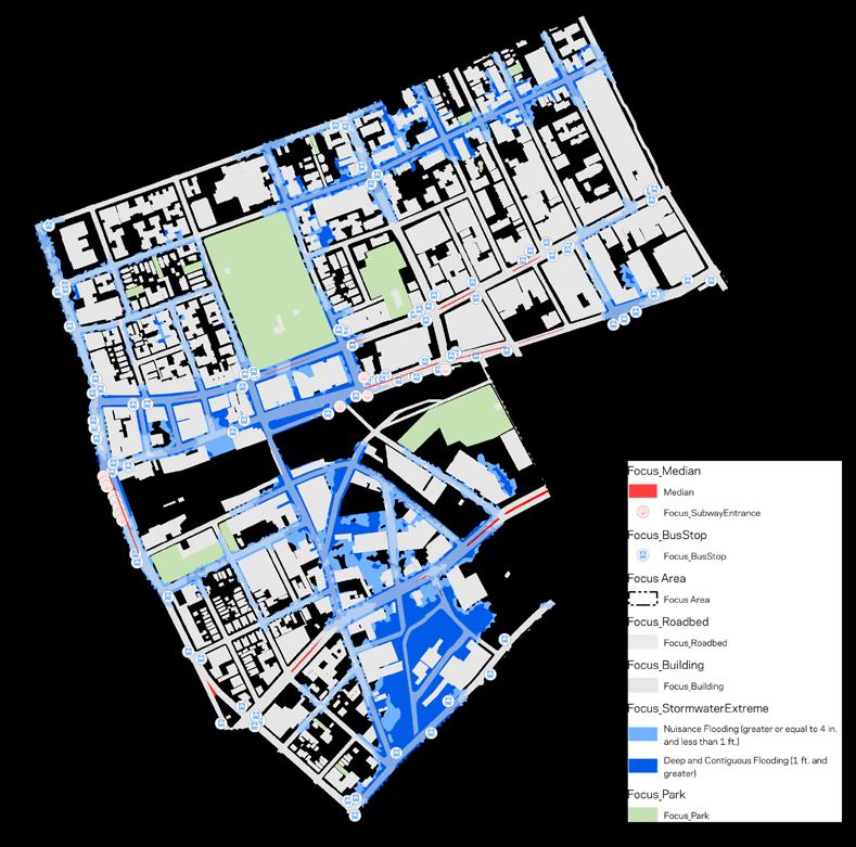
The Jamaica Climate Resiliency project targets urban design strategies for Queens Community District 12's Jamaica neighborhood. Aligned with NYC Mayor's Office of Climate & Environmental Justice's (MOCEJ) vision for New York City's resilience, the project addresses environmental issues like stormwater flooding, illegal dumping, and safety concerns in Downtown Jamaica. Key interventions include district-wide stormwater management, a green transit hub, a solar microgrid, and recommendations
DOWNTOWN JAMAICA
Climate Strong Communities: Inwood | MOCEJ CRP 5172: NYC Urban Planning Workshop LAND USE
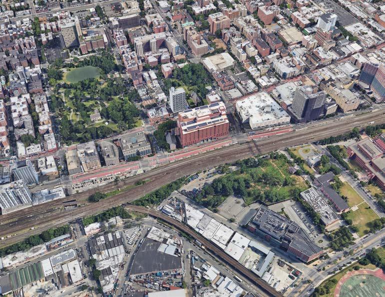
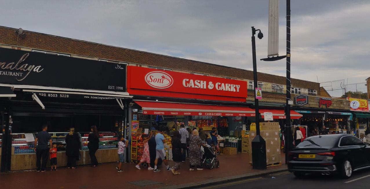
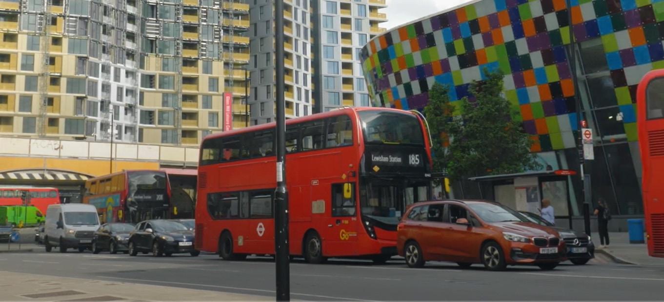
Downtown Jamaica boasts several defining features: firstly, its extensive railway connectivity provides residents easy access to various transportation options, including the Long Island Rail Road (LIRR), three subway lines (E, J, and Z). and the JFK AirTrain. Secondly, the area thrives with a bustling commercial corridor along Jamaica Avenue marked by numerous Black and immigrant owned businesses, alongside a diverse culinary experience within its food court. Lastly, the vicinity surrounding downtown Jamaica hosts a diverse industrial landscape, featuring low-story industrial sites such as steel manufacturing, ready-mix concrete suppliers, auto repair and car wash facilities, and even a poultry farm. The multi-faceted and vibrant identity of Downtown Jamaica sets it as an area that will see an increase in development and economic investment.
Downtown Jamaica stands out for its robust transportation links, vibrant commercial corridor along Jamaica Avenue with diverse businesses, and a mixed industrial landscape including steel manufacturing and auto repair facilities. This unique blend positions the area for ongoing development and economic growth.
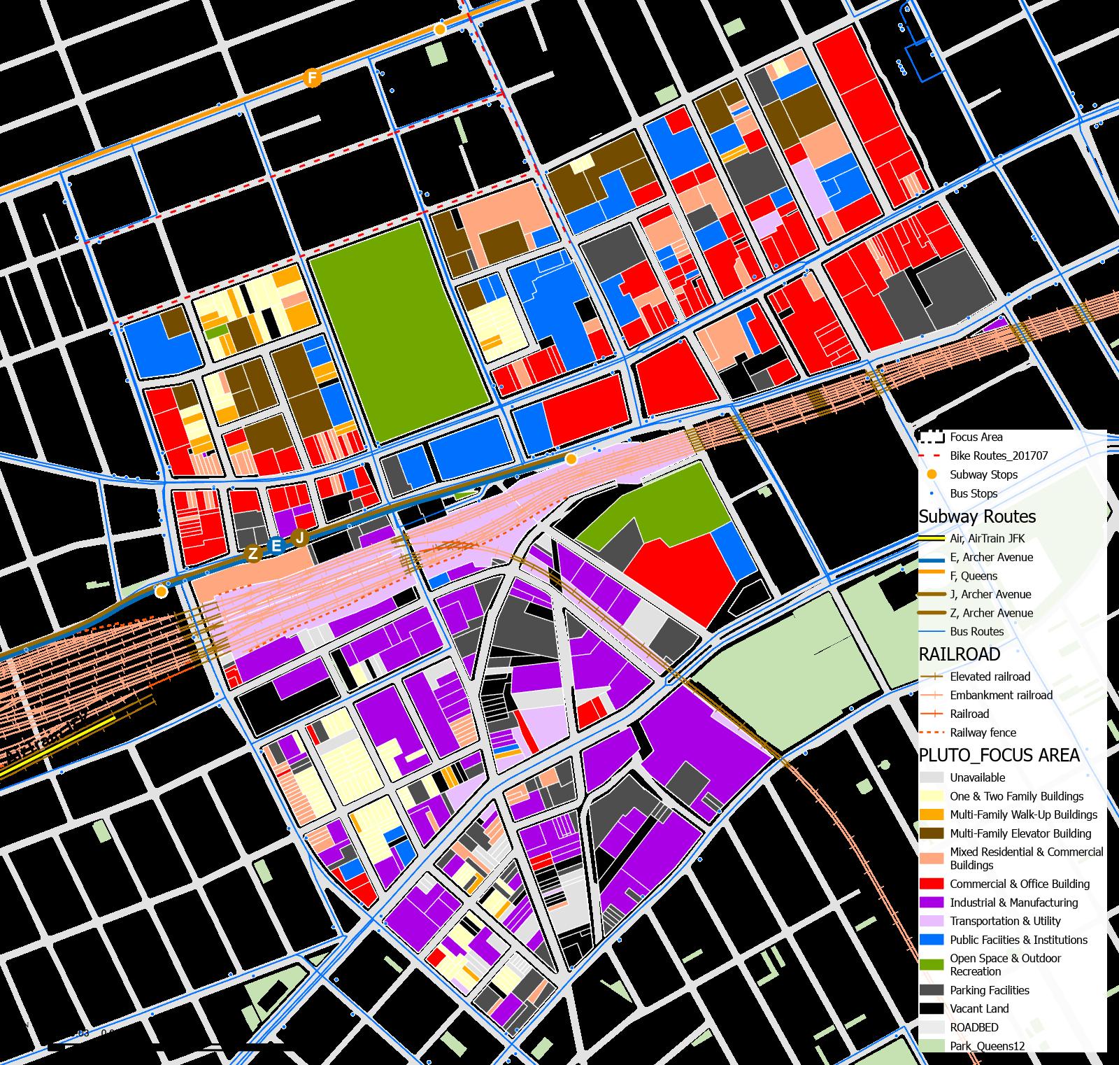
In Downtown Jamaica, Queens, land use zoning displays a distinct pattern: the northern half of the downtown district, particularly along the Jamaica Avenue corridor, is predominantly occupied by Commercial & Office spaces, providing a bustling retail and business environment. This area also hosts a significant concentration of Multi Family Elevator Buildings and Public Facilities & Institutions, reflecting a dense urban mix of residential and community services. In contrast, the southern portion of Downtown Jamaica contrasts sharply, characterized mainly by Industrial & Manufacturing zones and Transportation & Utility parcels. This division highlights the area's multifaceted urban landscape, where commercial vibrancy and industrial functionality coexist, underpinned by a rich cultural tapestry and accessible transportation network, including proximity to JFK Airport and robust public transit options.
DOWNTOWN JAMAICA
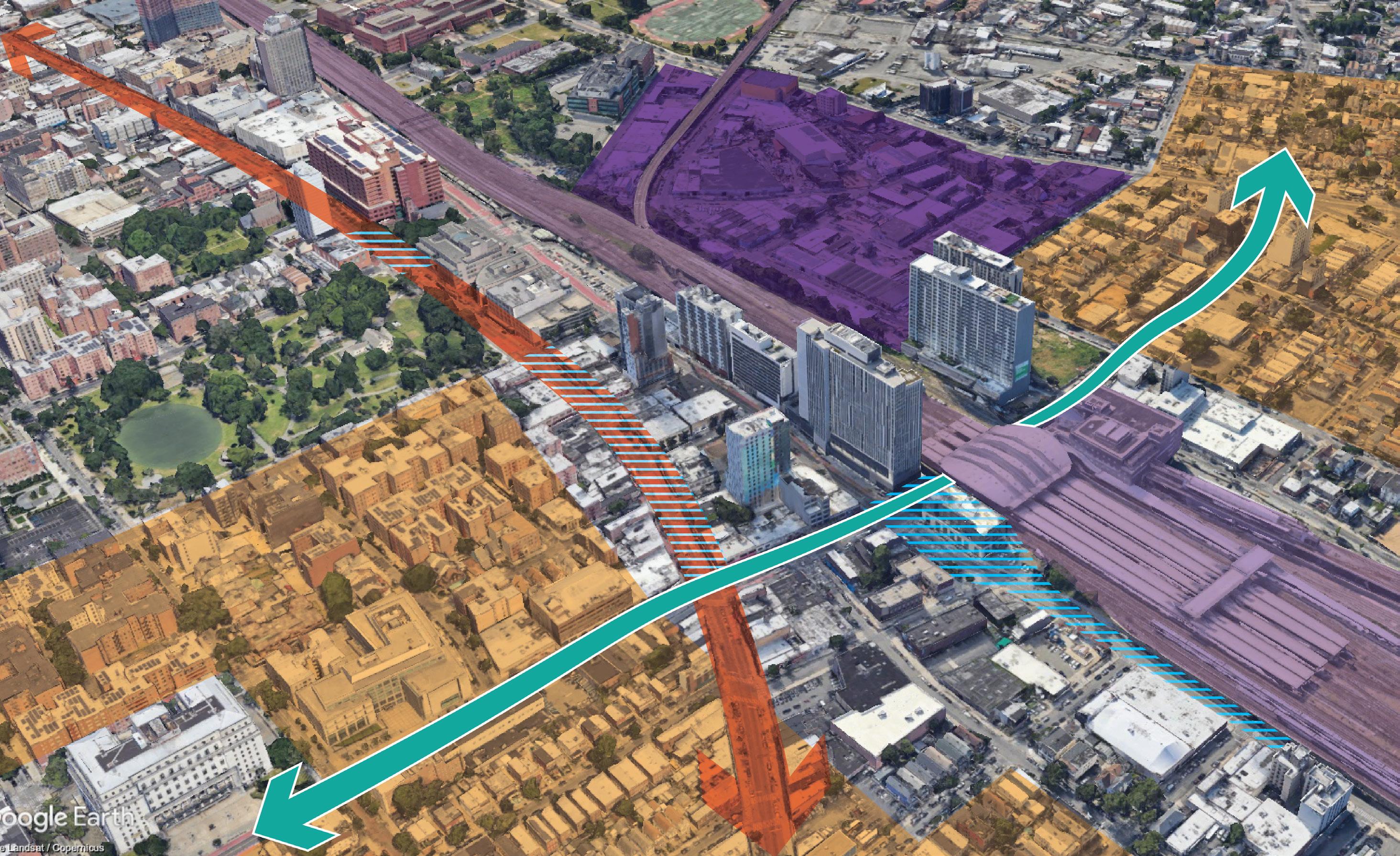
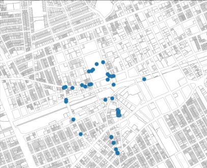
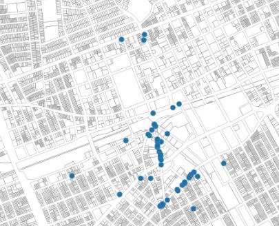
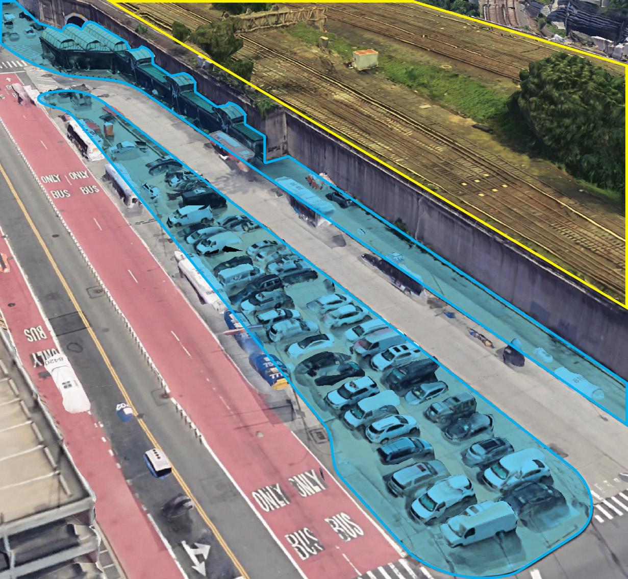
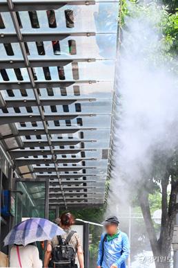
Jamaica Station serves as a central hub for the community, yet the presence of railroad tracks acts as a dividing boundary. On one side, there's a low-density residential area near Jamaica Avenue's commercial center, anchored by Rufus King Park and government buildings. On the opposite side of the tracks lies an industrial neighborhood with a neighboring residential area. This clear division poses challenges for residents to move between these areas. The industrial zone lacks public spaces or activities, except for a few churches. Both sides face stormwater issues due to an overworked sewer system, inadequate trash collection, and irregular street paving. This complex scenario requires targeted interventions tailored to each issue and site.
adjacent to railroad, industrial blocks limit direct accss to residential areas, rising safety issues in their surrounding conditions Enables the district to serve as transit hub, but its surrounding retaining walls limits pedestrian access to travel within the district Constant stormwater flooding issues along with absensce of green infrastructures and permeable pavements in the area In response to disconnected accessibility within the neighborhood, potential site for adaptation of green infrastructures along with streetscape interventions
AREA
AREA
FLOODING
FLOODING
FLOODING LACK OF CONNECTIVITY
CORRIDOR, JAMAICA AVE
PROXIMITY 18 Climate Resilience Neighborhood Studies: JAMAICA | MOCEJ CRP 5172: NYC Urban Planning Workshop
INDUSTRIAL AREA Situating
RESIDENTIAL
RESIDENTIAL
RAILROADS STORMWATER
STORMWATER
STORMWATER
COMMERCIAL
CRITICAL
CRITICAL Acting Jamaica also act two distinct characterized adjacent Avenue. Park On the industrial residential makes from incentive spaces from are plagued an overworked collection, factors. diverse each CRITICAL PROXIMITY
to: amounts bussinesses.
culinary industrial
8
2
01
Climate Resilience Neighborhood Strategy


Fieldwork
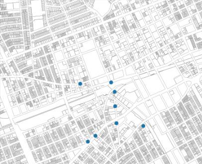
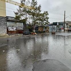
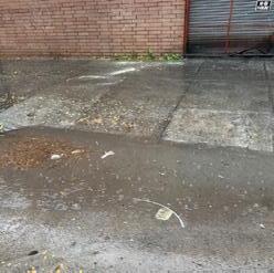
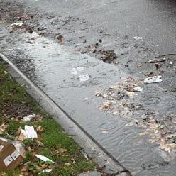
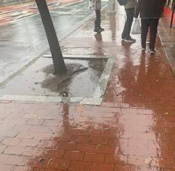
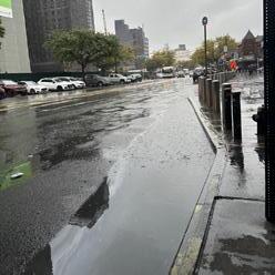
A site visit in mid-October 2023, during rainy weather, provided insights into on-the-ground conditions. The collected photographic data highlighted prevalent stormwater issues, including significant trash and illegal dumping concentrated in industrial and residential zones. Overall, the data aligned with the team's flood stormwater maps.
FRAMEWORK
CORRELATION OF SITE CONDITIONS AND MAPPING ANALYSIS
In order to gain an understanding of on-theground site conditions, a site visit was conducted in mid-October 2023 amidst rainy weather. This inclement weather provided a clear view of prevalent stormwater issues, shedding light on potential underlying causes. Analyzing the photographic data collected revealed a concerning prevalence of trash and illegal dumping, notably concentrated in the industrial and residential zones. The industrial area, in particular, showcased severe flooding issues and exhibited a higher incidence of graffiti and vandalism, aligning with community feedback regarding safety concerns within this zone expressed by residents. All in all, the photographic data collected aligned with the flood stormwater maps the team developed.
MASTERPLAN
This masterplan outlines three main buckets of resiliency interventions: district-wide stormwater management, a green transit hub, and a solar microgrid. The stormwater toolkit containing rain gardens among other interventions is to serve at a multitude of locations where right-of-way construction and stormwater issues are in alignment. The green transit hub is to take place at the intersection of Archer Avenue and 150th Street, with the solar microgrid being right across in the government-owned properties.
To address challenges like stormwater flooding, unsafe streets, and potential gentrification, a comprehensive approach is essential. The resilient framework focuses on climate resilience, a green transit hub, and preserving the industrial heritage.
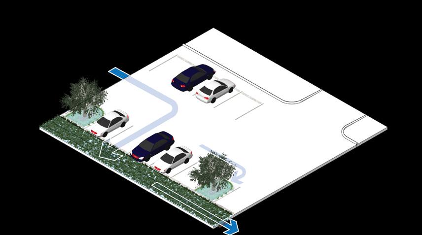
GREEN TRANSIT HUB 01 RAIN GARDEN 03 PERMEABLE SURFACE PARKING 01 TRANSIT PLAZA 02 BIOSWALE MEDIAN 04 DRY DETENTION TURF 02 COMMUNITY CENTER MASTERPLAN 20 Climate Resilience Neighborhood Studies: JAMAICA MOCEJ CRP 5172: NYC Urban Planning Workshop MASTERPLAN This
serve
way
the intersection
with in the government-owned
masterplan resiliency management, microgrid. rain gardens
at
construction alignment. at
Street,
DRAINAGE ISSUE MAJOR ILLEGAL DUMPING GRAFFITI SIVE VISIT REPORT 19 Climate Resilience Neighborhood Studies: JAMAICA MOCEJ CRP 5172: NYC Urban Planning Workshop
Climate Strong Communities: Inwood MOCEJ CRP 5172: NYC Urban Planning Workshop
SITE
FOCUS AREA: OPPORTUNITIES & CONSTRAINTS 2 17 Climate Strong Communities: Inwood MOCEJ CRP 5172: NYC Urban Planning Workshop DOWNTOWN JAMAICA Green Transit Hub Climate Resilience Community Heritage Unsafe Street Stormwater Flooding Fear of Displacement Street Pavement Improvement Rain Garden on Street Tree Bed Permeable Parking Lot Bioswale on Median Increased Green Spaces Street Maintenance Potential Gentrification Declining Manufacturing Industry Increased Tree Canopy Transit Hotspot Widen Pedestrian Road Greenstreets More street lights Introducing New Industries Conversion of Vacant Lots Engagement of Private Sector Enhanced Accessibility Cleaned Street Drainage Synthetic Turf Bioretention Increased Bike Lane Reuse of Pocket Lots Local Business Support Community Engagement Neighborhood Branding Green & Blue Roofs FRAMEWORK 17 Climate Resilience Neighborhood Studies: JAMAICA MOCEJ CRP 5172: NYC Urban Planning Workshop FROM ISSUE TO SOLUTION Tackling multifaceted challenges like stormwater flooding, unsafe streets, fear of displacement, potential gentrification, and a declining manufacturing industry requires a comprehensive approach. The resilient framework centered on climate resilience, a green transit hub, and honoring the area's industrial heritage aims to fortify the community against flooding, enhance safety, prevent displacement, safeguard against potential gentrification, and revitalize the manufacturing industry, fostering a resilient and thriving Downtown Jamaica.
VISIT
PROPOSED INTERVENTIONS 6 29 Climate Strong Communities: Inwood MOCEJ CRP 5172: NYC Urban Planning Workshop
02
Toolkit 1 & 2
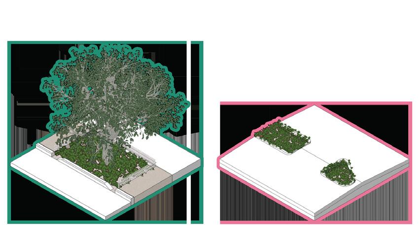
The first part of our resiliency strategy primarily focuses on repurposing existing tree beds into rain gardens and transforming numerous medians into bioswales in Downtown Jamaica. Rain gardens will manage surface water runoff while enhancing biodiversity and the pedestrian experience, adhering to NYC DEP guidelines. Bioswales mitigate stormwater flooding and the urban heat island effect, promoting resilience in high traffic areas.
By integrating green infrastructure, we aim to create a more sustainable and vibrant urban environment. These initiatives prioritize environmental stewardship. Through thoughtful interventions, we envision Jamaica thriving with sustainability, fostering a healthier and more livable urban ecosystem for residents and visitors alike.
Climate Resilience Neighborhood Strategy
TOOLKIT 1: RAIN GARDENS
TOOLKIT 1: RAIN GARDEN
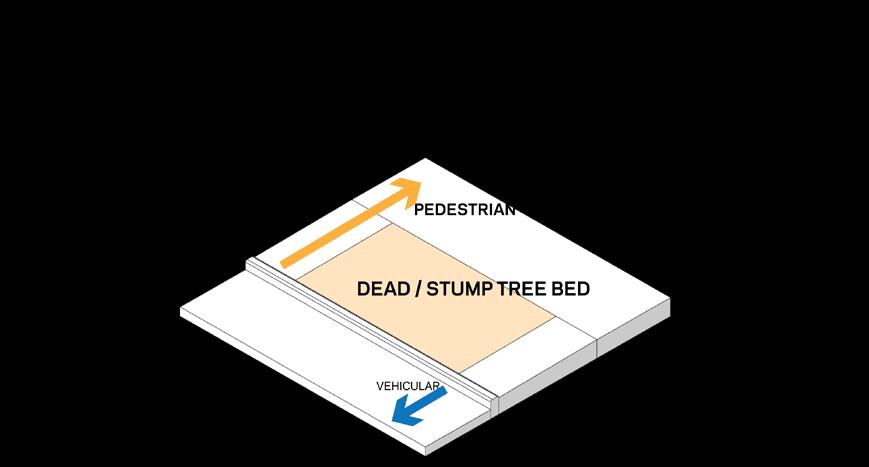
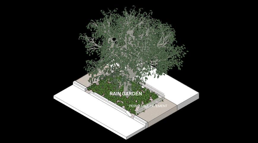
OVERVIEW OF RAIN GARDENS
The initial step of our resiliency strategy is the transformation of existing tree beds, particularly those with dead or stumped trees, into functional rain gardens. This selection was made after a detailed evaluation process, where these specific tree beds were chosen for their ease of adaptation and construction. Additionally, our criteria was further refined to select tree beds situated directly on the curb, rather than those set back from it. This deliberate choice ensures that the creation of rain gardens does not interfere with pedestrian flow on the sidewalks. The installation of rain gardens in these chosen locations is poised to offer multiple environmental benefits. Primarily, they will serve as effective solutions for managing surface water runoff from both pedestrian pathways and adjacent roadways. This is a key component in our approach to sustainable stormwater management within the urban landscape. Furthermore, these rain gardens are expected to contribute to the increase in local biodiversity. They will also augment the tree canopy in the area, providing enhanced shade and thus improving the pedestrian experience. This initiative represents a significant step towards fostering a more sustainable and livable urban environment.
Climate Resilience Neighborhood Studies: JAMAICA MOCEJ CRP 5172: NYC Urban Planning Workshop
33 Climate Strong Communities: Inwood MOCEJ CRP
The first intervention transforms tree beds into rain gardens on curbs, managing surface water for sustainability. These gardens enhance biodiversity, augment the tree canopy, provide shade, and improve the urban pedestrian experience. This initiative marks a significant step towards fostering a more sustainable and livable urban environment.
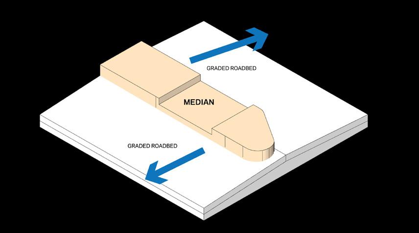
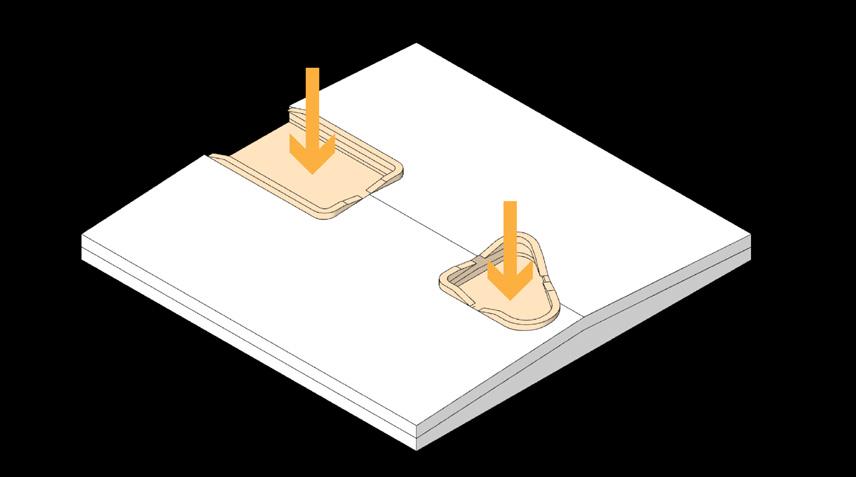
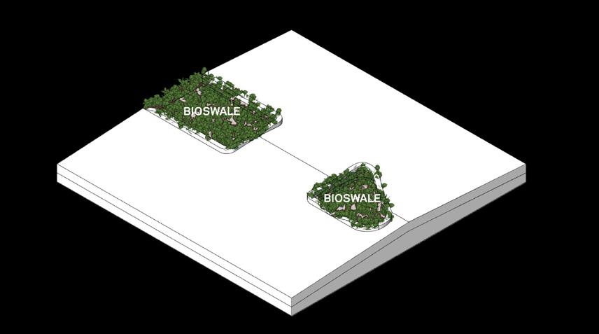
TOOLKIT 2: BIOSWALE MEDIAN
Climate Resilience Neighborhood Studies: JAMAICA MOCEJ CRP 5172: NYC Urban Planning Workshop
The second intervention in Downtown Jamaica proposes transforming barren medians into bioswales, addressing inadequate maintenance and stormwater flooding. This strategy, focused on major roads, aims to enhance environmental resilience in high-traffic areas near industrial zones, contributing to downtown Jamaica's overall infrastructure.
Climate Strong Communities: Inwood MOCEJ CRP 5172: NYC Urban Planning Workshop
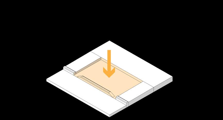
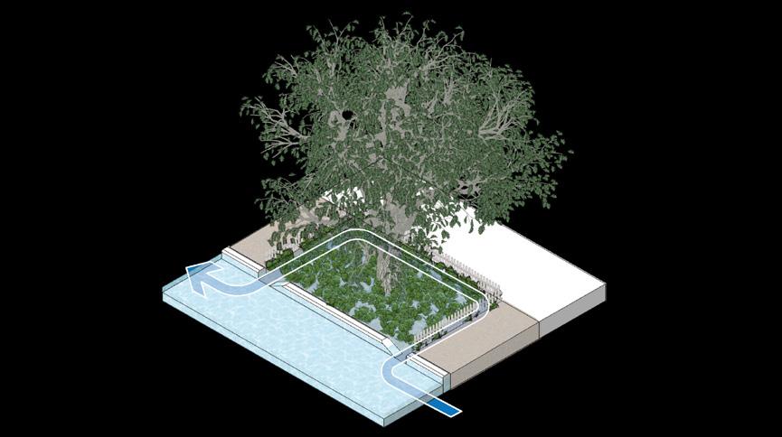
Pedestrian streets with dead tree beds on the curb will become rain gardens, marked on the map with red points. Following NYC DEP guidelines, the excavation and installation process will ensure a minimum length of 10 feet, with protective fences. These rain gardens aim to absorb and contain overflow, contributing to effective stormwater management.
RAIN GARDEN DESIGN
The existing condition are marked by a dead located on the curb side. these sites will be the shown by the red points contents of the empty excavation. The subsequent garden will adhere to the the New York City Department Protection (NYC DEP), length of 10 feet. Additionally, will be erected around the the likelihood of littering.
The overarching goal is to absorb and contain roadbed, taking into account Subsequently, the released discharged gradually, stormwater management.
PROPOSED INTERVENTIONS
TOOLKIT 2: BIOSWALE MEDIAN
OVERVIEW OF BIOSWALES
The second intervention involves the transformation of existing medians into bioswales. Downtown Jamaica, being a transit-oriented district, features wide roads with multiple lanes, leading to the presence of medians in the center of these vehicular pathways. Observations made during our site visit revealed that these medians are primarily composed of concrete or asphalt and lack any form of planting. Furthermore, they suffer from inadequate maintenance and are often littered with trash.
The introduction of bioswales in these medians presents an opportunity to mitigate the effects of inland stormwater flooding, particularly on major roads with high traffic volumes where medians are more common. This strategy is especially relevant in areas with wide roads near industrial and commercial zones. The implementation of bioswales in the heart of downtown Jamaica is anticipated to significantly alleviate flooding issues, contributing to the environmental and infrastructural resilience of the area.
Climate Strong Communities: Inwood MOCEJ
PROPOSED INTERVENTIONS 6 35
CRP
The diagram shows downtown Jamaica's medians extending to pedestrian crossings with graded roads. Concrete medians will be excavated for bioswales installation on high points, avoiding tall trees for visibility. Bioswales address drainage challenges and mitigate floods, while adding green elements to roadbeds reduces the urban heat effect.
BIOSWALE DESIGN
The initial diagram illustrates existing conditions of medians, which often extend crossings. The adjacent roads by a graded surface. As part existing concrete or asphalt excavation.
The installation of bioswales these medians, typically the graded roadbed crowns. planting tall trees in these clear visibility for vehicle drivers. stormwater flooding leads graded vehicular roads due to drainage infrastructure The introduction of bioswales supplementary solution to aiming to contain and enhanced flood mitigation.
Furthermore, incorporating elements into the roadbeds alleviating the urban heat roads with higher traffic medians. This holistic approach both drainage challenges considerations in urban planning.
21
TOOLKIT 01 RAIN GARDEN
INTERVENTIONS 6
PROPOSED
5172: NYC Urban Planning Workshop
01 RAIN GARDEN 22 Climate Resilience Neighborhood Studies: JAMAICA MOCEJ CRP 5172: NYC Urban Planning Workshop
TOOLKIT
PROPOSED
BIOSWALE
23
TOOLKIT 02
MEDIAN
Climate Strong Communities: Inwood MOCEJ CRP 5172: NYC Urban Planning Workshop
02 BIOSWALE MEDIAN 24 Climate Resilience Neighborhood Studies: JAMAICA MOCEJ CRP 5172: NYC Urban Planning Workshop
TOOLKIT
5172: NYC Urban Planning Workshop
03
Toolkit 3 & 4
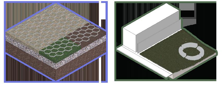
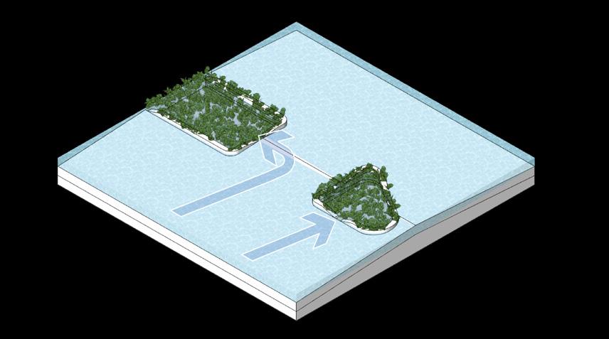
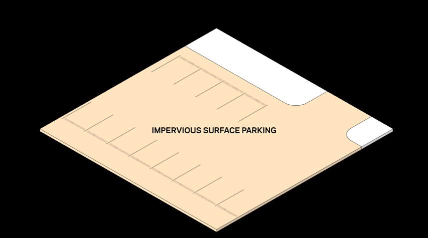
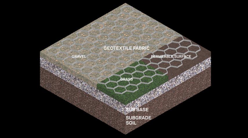
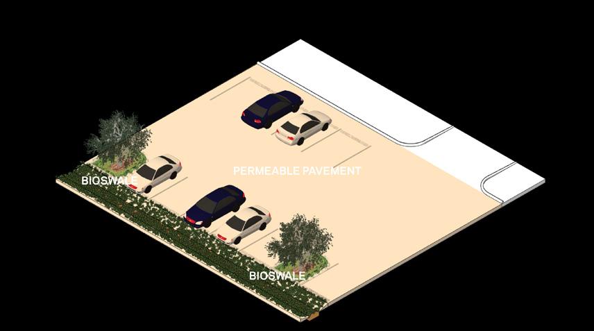
In the downtown area, where many large surface parking lots dominate the landscape, our intervention will target these areas for transformation into permeable parking lots. Priority is given to specific lots especially susceptible to extreme stormwater flooding,. The proposed transformation involves utilizing geotextile fabrics to create permeable surfaces, complemented by bioswales at lot edges to enhance permeability and introduce greenery.
Both of these interventions not only address flooding concerns but also contribute to heat mitigation. By leveraging Digital Elevation Model data and identifying vacant lots, we aim to target areas of surface runoff accumulation during flooding events, prioritizing publicly owned parcels for implementation. This strategy illustrates our commitment to sustainable and resilient urban development in downtown Jamaica.
PROPOSED INTERVENTIONS
Climate Resilience Neighborhood Strategy
TOOLKIT 3: PERMEABLE PARKING
TOOLKIT 3: PERMEABLE PARKING
OVERVIEW OF PERMEABLE PARKING
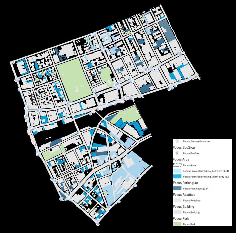
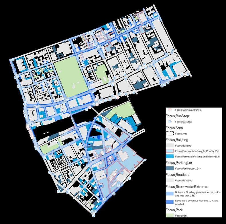
Downtown Jamaica, distinct from areas with high-rise buildings predominantly situated in the commercial corridor, features an abundance of surface parking lots. The third intervention focuses on these parking areas, aiming to transform them into permeable parking lots. In a comprehensive assessment of the 134 surface parking locations, we have categorized these lots into two priority groups for potential intervention.
The first priority group includes parking lots that coincide with areas of moderate inland flooding. These are considered urgent cases for intervention due to their susceptibility to regular flooding issues. The second priority group consists of lots that intersect with regions prone to extreme stormwater flooding. This categorization is strategic, highlighting parking areas that are in dire need of flooding solutions.
PERMEABLE PARKING
By prioritizing in this manner, we propose a focused approach where interventions initially target lots with the most urgent need for flood mitigation. This plan allows for an effective and gradual expansion of the initiative, addressing the flood risks in a systematic and impactful way.
Climate Resilience
Climate Resilience Neighborhood Studies: JAMAICA MOCEJ CRP 5172: NYC Urban Planning Workshop
37 Climate Strong Communities: Inwood MOCEJ CRP 5172: NYC Urban Planning Workshop TOOLKIT
25
The third intervention focuses on these parking areas, aiming to transform them into permeable lots. In an assessment of 134 surface parking locations, we've prioritized two groups: urgent cases in flood-prone areas and those vulnerable to extreme stormwater flooding.
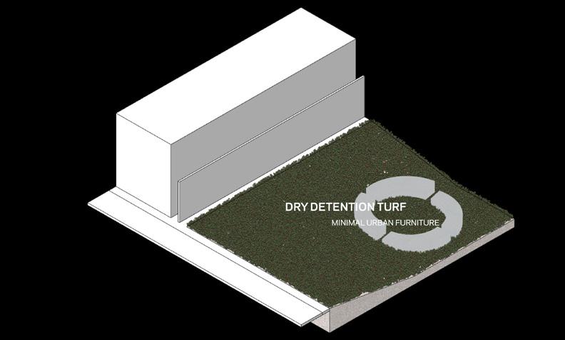
TOOLKIT 4: DRY DETENTION TURF
Stormwater flooding in Jamaica persists despite a $2 billion budget in 2021. We turned to natural methods using Digital Elevation Model data due to drainage system construction delays. Our proposed dry detention turf validates our natural intervention strategy for enhanced resiliency.
The prevailing condition parking lots in downtown characterized by impermeable Our proposal involves approach, incorporating create permeable surfaces. their permeability and properties, these fabrics laid to establish a durable surface. The geotextile membrane, permit water passage while larger particles, will be the underlying drainage system. then be finalized with a layer permeable pavement, supported sub-base and subgrade with the permeable pavements, the integration of bioswales parking lots, especially with pedestrian streets This addition not only but also introduces additional shade, thereby mitigating surfaces and parked vehicles. inland flooding, these permeable bioswales will play a pivotal overflow. Notably, the bioswales mitigating water overflow greenery into the urban landscape.
Downtown Jamaica's surface parking lots are slated for transformation, adopting geotextile fabrics to instill permeability and ground stability. This innovative approach incorporates bioswales at lot edges, not only enhancing permeability but also offering resilience during inland flooding.
TOOLKIT 4: DRY DETENTION TURF
DRY DETENTION TURF LOCATION
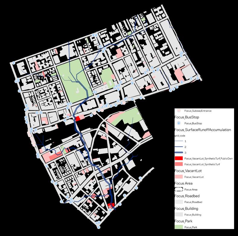
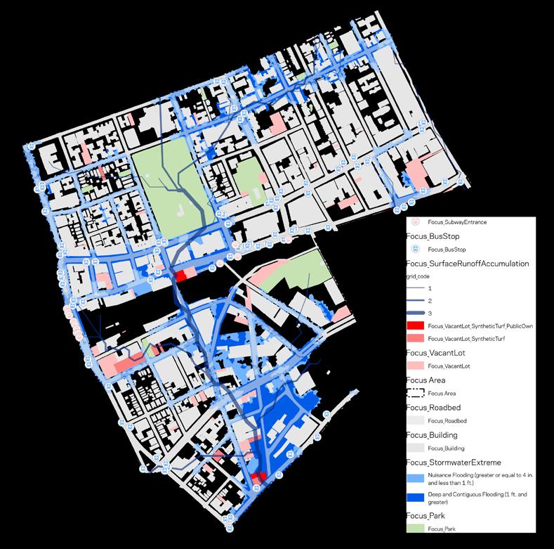
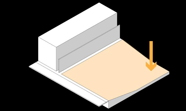
We propose the installation of dry detention turf on selected parcels in downtown Jamaica, specifically targeting areas where water naturally flows during street-level overflows. This strategy aims to minimize direct interventions on existing grey infrastructure, focusing instead on leveraging the area's natural conditions to effectively manage severe inland stormwater flooding.
The first step in this process involves identifying vacant lots in downtown Jamaica. Once these lots are located, we will analyze which ones overlap with areas of surface runoff accumulation during flooding events.
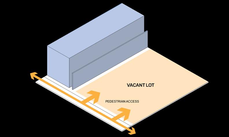
An important consideration in this process is the ownership of these parcels. Publicly owned parcels are prioritized as they typically offer greater potential for implementing such installations. By distinguishing between publicly and privately owned lots, we can more effectively plan and execute our intervention strategy.
PROPOSED INTERVENTIONS 6 40
DRY DETENTION TURF
The first diagram outlines of selected vacant lots, to occupied areas with access from pedestrian is to repurpose these stormwater flooding mitigation, our previous interventions. will undergo grading to navigation of accumulated the lot. Following this, we lot's surface, opting for a grass that requires trimming maximize the utility of the furniture may be placed on it not only into a vacant open area for recreational
Our objective is to maintain turf under normal conditions. heavy rain or overflow in these turfs will serve absorbing and containing flooding event subsides, release the stored water. only effectively manages revitalizes underutilized into functional and beneficial community.
PROPOSED Climate
The diagram outlines repurposing vacant lots for stormwater mitigation through grading and low-maintenance turf. These spaces double as detention basins during heavy rain, managing stormwater and creating functional community areas. Thus this strategy aims to revitalize underutilized spaces for the benefit of the local residents.
TOOLKIT 03 PERMEABLE SURFACE PARKING
6
03 PERMEABLE SURFACE PARKING
26
Neighborhood Studies: JAMAICA MOCEJ CRP 5172: NYC Urban Planning Workshop
PROPOSED INTERVENTIONS Climate Strong Communities: Inwood MOCEJ CRP 5172: NYC Urban Planning Workshop TOOLKIT 04 DRY DETENTION TURF 28 Climate Resilience Neighborhood Studies: JAMAICA MOCEJ CRP 5172: NYC Urban Planning Workshop Detention_Turf Detention_Turf_Public_Own Detention_Turf Detention_Turf_Public_Own
Climate Strong Communities: Inwood MOCEJ CRP 5172: NYC Urban Planning Workshop TOOLKIT 04 DRY DETENTION TURF 31 Climate Resilience Neighborhood Studies: JAMAICA MOCEJ CRP 5172: NYC Urban Planning Workshop
Strong Communities: Inwood MOCEJ
5172: NYC Urban Planning Workshop
CRP
04
Transit Hub
Climate Resilience Neighborhood Strategy
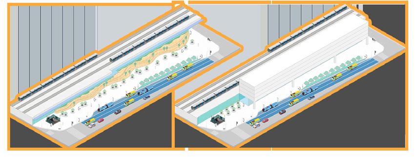
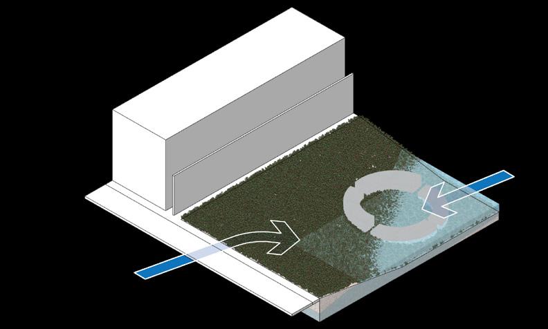
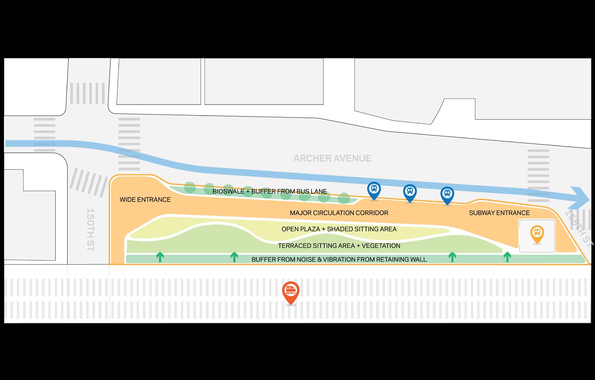
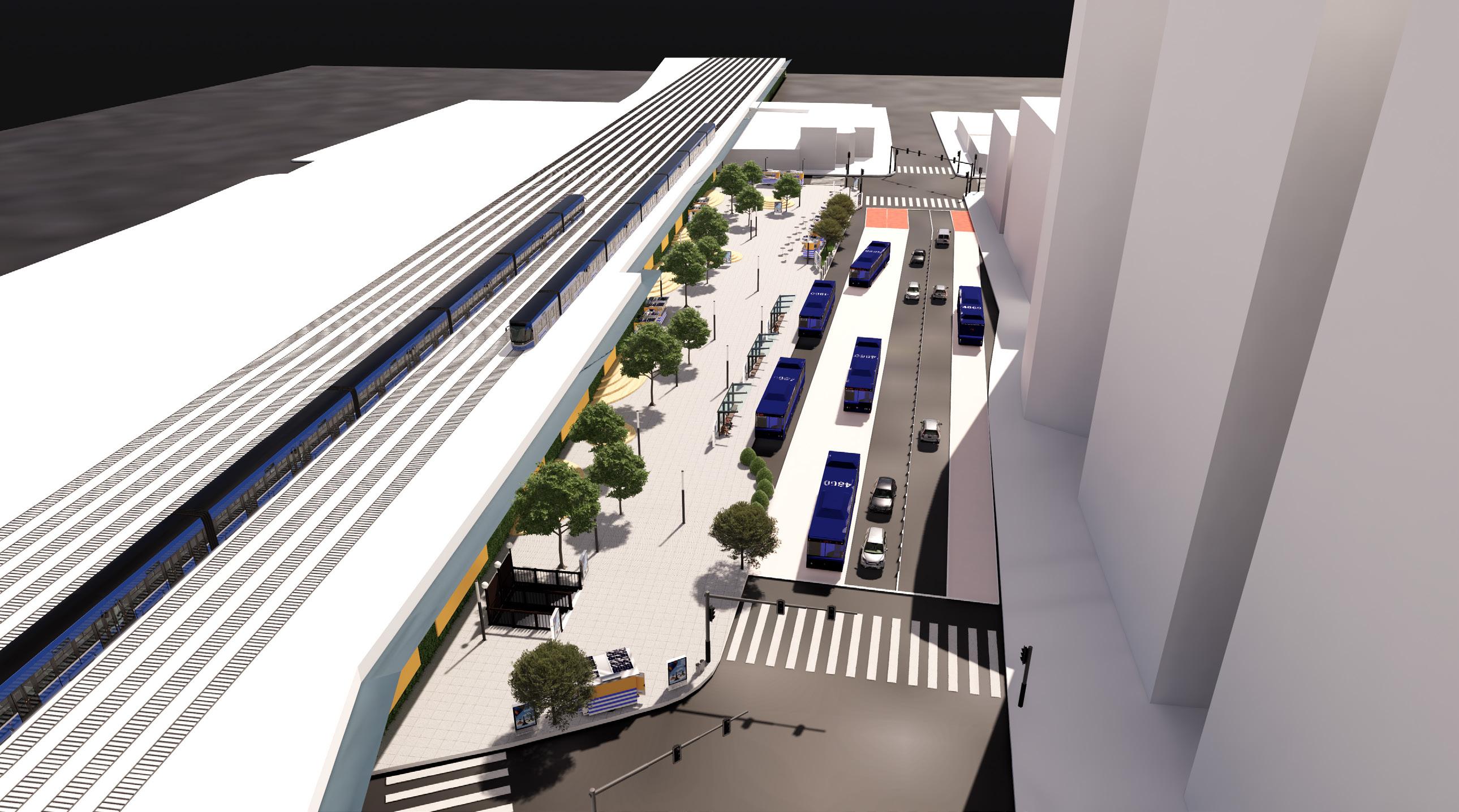
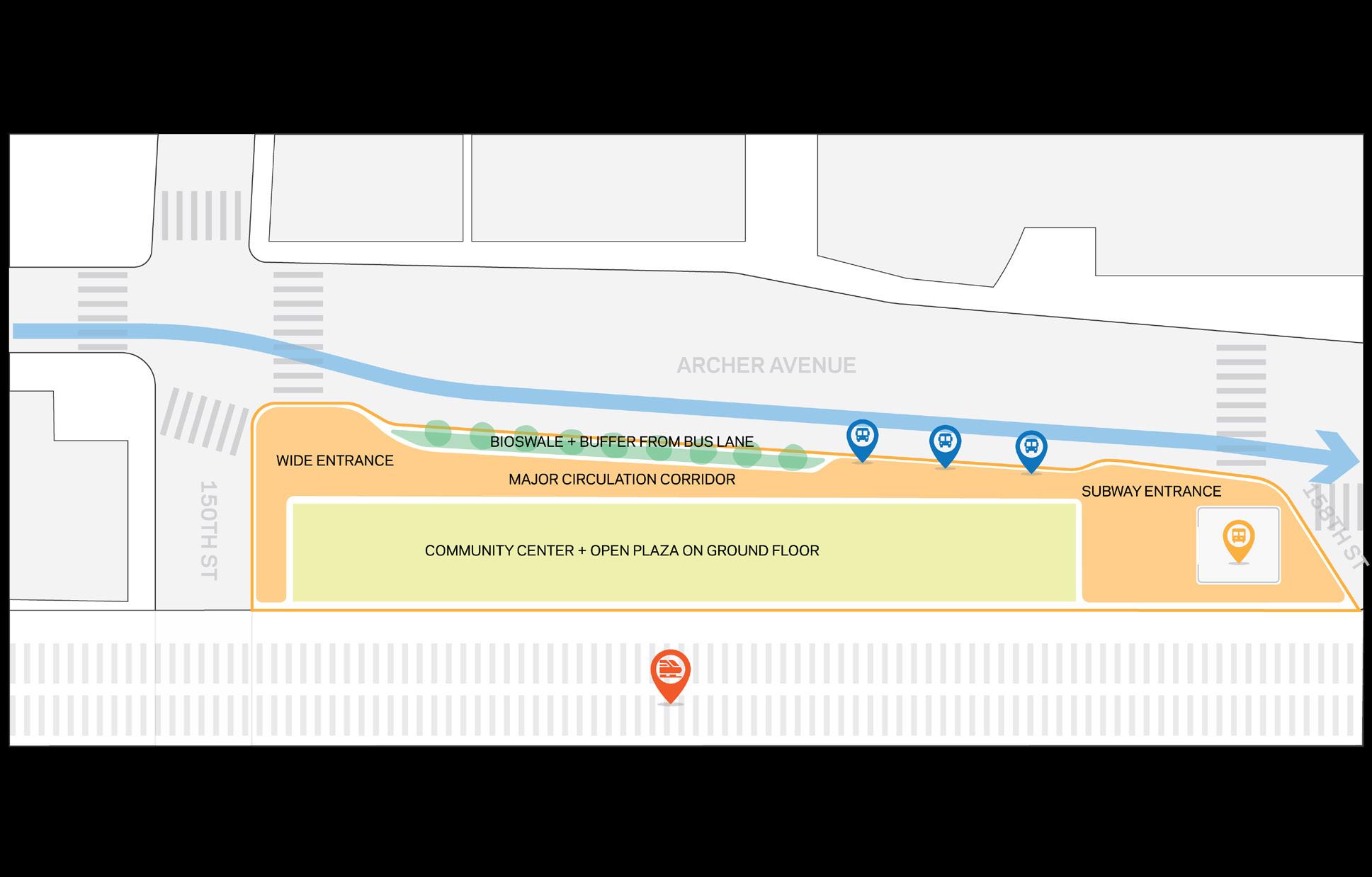
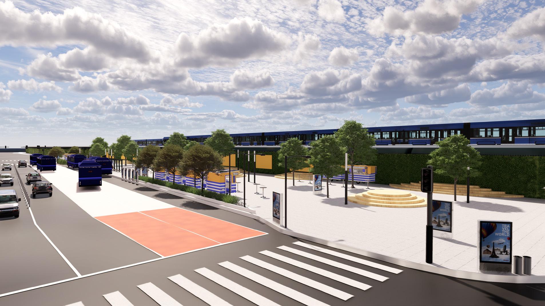
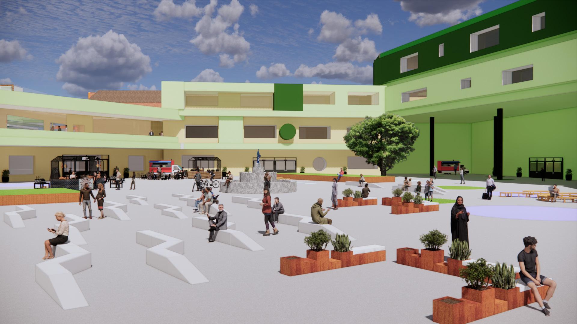
Transforming an existing bus station and adjacent parking lot near Jamaica Avenue into a green bus hub, strategically located near LIRR and AirTrain stations, provides a unique opportunity to enhance urban transit, support local businesses, and address environmental concerns. The project emphasizes flood risk mitigation through elevated structures, advanced drainage systems, and the use of permeable materials for road pavements. Parking areas are redesigned with permeable surfaces and bioretention facilities. Additionally, the plan includes a green roof by the railroad to reduce noise pollution, provide shade, enhance pedestrian connectivity, and prioritize sustainable materials and technologies, forming a holistic approach to elevate the commuter experience while addressing urban challenges such as flooding, noise, and heat islands.
GREEN TRANSIT HUB: PROXIMITIES
TRAFFIC ORIENTED
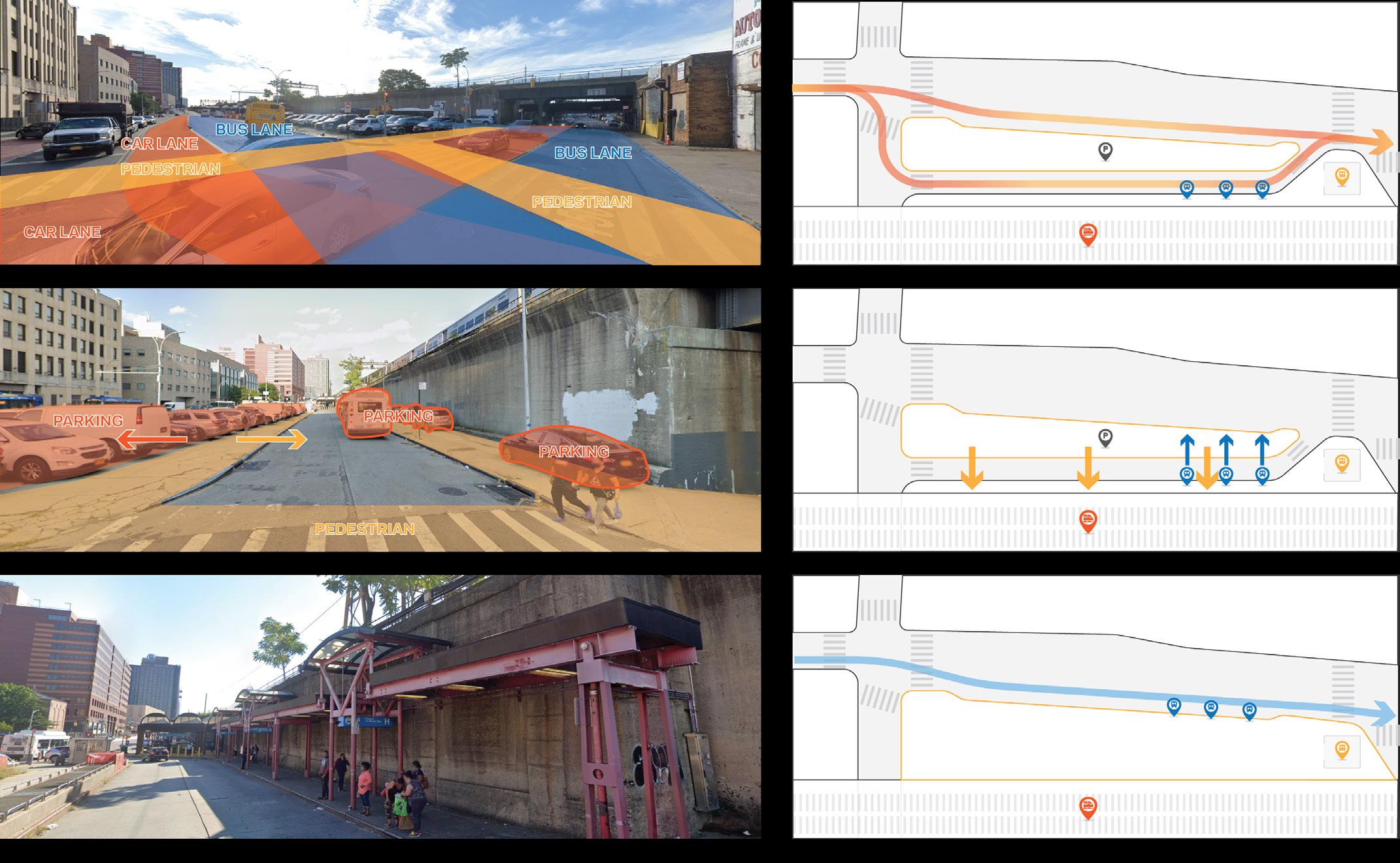
The current configuration places the parking lot on the same level as the pedestrian street, lacking any curbs. Additionally, the existing bus stations adjacent to the elevated railroad suffer from poor maintenance and inadequate lighting. Upon closer inspection of this intersection, a significant traffic issue becomes apparent, with congestion occurring at the bus pick-up and drop-off zone. The current layout necessitates buses to navigate two tight turns for access, prompting the team to propose extending the island and relocating the bus stop zone to the main street level. This adjustment aims not only to alleviate congestion but also to provide a safer waiting area for pedestrians. Given the current state of the site, featuring multiple parking areas that impede pedestrian movement and compromise safety while waiting for buses, this proposal becomes crucial for overall traffic flow and pedestrian well-being.
GREEN TRANSIT HUB: SITE OVERVIEW
Transforming a bus station and parking lot near Jamaica Avenue into a green bus hub addresses flood risk and urban challenges. The holistic approach enhances transit, supports local businesses, and incorporates sustainable features like permeable surfaces and green roofs to improve the overall commuter experience.
The current layout lacks curbs, causing bus pick-up congestion. The proposal suggests extending the island and relocating the bus stop to the main street level for improved traffic flow and pedestrian safety, aiming to enhance overall traffic experience and create a secure waiting area.
Revamping an existing bus station and adjacent parking lot into a green bus hub located near Jamaica Avenue, in proximity to LIRR and AirTrain stations, presents a distinctive opportunity to improve urban transit, bolster local businesses, and address environmental issues. The project focuses on flood risk mitigation by employing elevated structures and advanced drainage systems, using permeable materials to upgrade road pavements, and transforming parking areas into spaces with permeable surfaces and bioretention facilities. Additionally, the plan involves incorporating a green roof by the railroad to diminish noise pollution and offer shade, improving pedestrian connectivity to the nearby commercial corridor, and ensuring the use of sustainable materials and technologies in the design. This holistic approach aims not only to elevate the commuter experience but also to tackle pressing urban challenges such as flooding, noise, and heat islands.
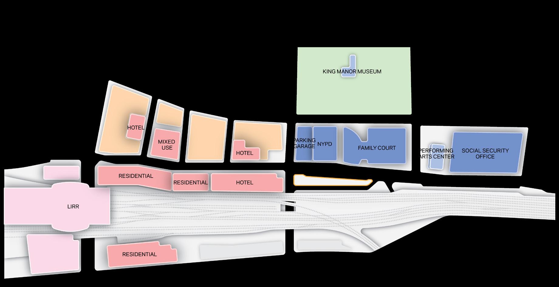
The Archer Avenue transit hub, conveniently located, allows for a quick walk to Jamaica Station and nearby government offices in under 10 minutes. The central location attracts new residential and commercial developments, benefiting from the high traffic of daily commuters and residents.
TRANSIT HUB POTENTIAL 34 Climate Resilience Neighborhood Studies: JAMAICA MOCEJ CRP 5172: NYC Urban Planning Workshop TRANSIT HUB POTENTIAL The Archer Avenue transit location where one is able Station and several government than 10 minutes. Alongside a multitude of new residential developments capitalizing on location and the thousands and residents that pass through
Climate Strong Communities: Inwood MOCEJ CRP 5172: NYC Urban Planning Workshop TRAFFIC ORIENTED TRANSIT-ORIENTED INTERSECTION BUS LANE TRAFFIC CONGESTION UNPROTECTED PEDESTRIAN CIRCULATION EXPANSION OF THE LOT CURRENT BUS STATION CONDITION REROUTED BUS LANE 35 Climate Resilience Neighborhood Studies: JAMAICA MOCEJ CRP 5172: NYC Urban Planning Workshop
PROPOSED INTERVENTIONS 6 47 Climate Strong Communities: Inwood MOCEJ CRP 5172: NYC Urban Planning Workshop Transforming an existing bus station and adjacent parking lot into a green bus hub near Jamaica Avenue, close to LIRR and AirTrain stations, presents a unique opportunity for enhancing urban transit and supporting local businesses while addressing environmental concerns. The project will focus on mitigating flood risks through elevated structures and advanced drainage systems, improving road pavements with permeable materials, and converting parking areas into spaces with permeable surfaces and bioretention facilities. The plan includes installing a green roof by the railroad to reduce noise pollution and provide shade, enhancing the pedestrian connection to the nearby commercial corridor, and ensuring the design integrates sustainable materials and technologies. This comprehensive approach not only aims to enhance the commuter experience but also contributes to solving critical urban challenges like flooding, noise, and heat islands. ELEVATED RAILROAD POTENTIAL GREEN ROOF EXISTING PARKING LOT EXISTING BUS ROUTE PERMEABLE SURFACE ADJACENT COMMERCIAL CORRIDOR ADJACENT TRAIN STATION HIGH COMMUTE VOLUME POTENTIAL FOR BIORETENTION POTENTIAL FOR GREEN TRANSIT HUB NOISE RESTRICTED PEDESTRIAN MOVEMENT POTENTIAL INVERTENTION 32 Climate Resilience Neighborhood Studies: JAMAICA MOCEJ CRP 5172: NYC Urban Planning Workshop
GREEN TRANSIT HUB: CURRENT TRAFFIC
CURRENT SITE
PROPOSED INTERVENTIONS 6 44 Climate Strong Communities: Inwood MOCEJ CRP 5172: NYC Urban Planning Workshop
05
Climate Resilience Neighborhood Strategy
OPTION 1: RESILIENT TRANSIT HUB
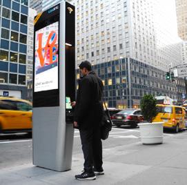
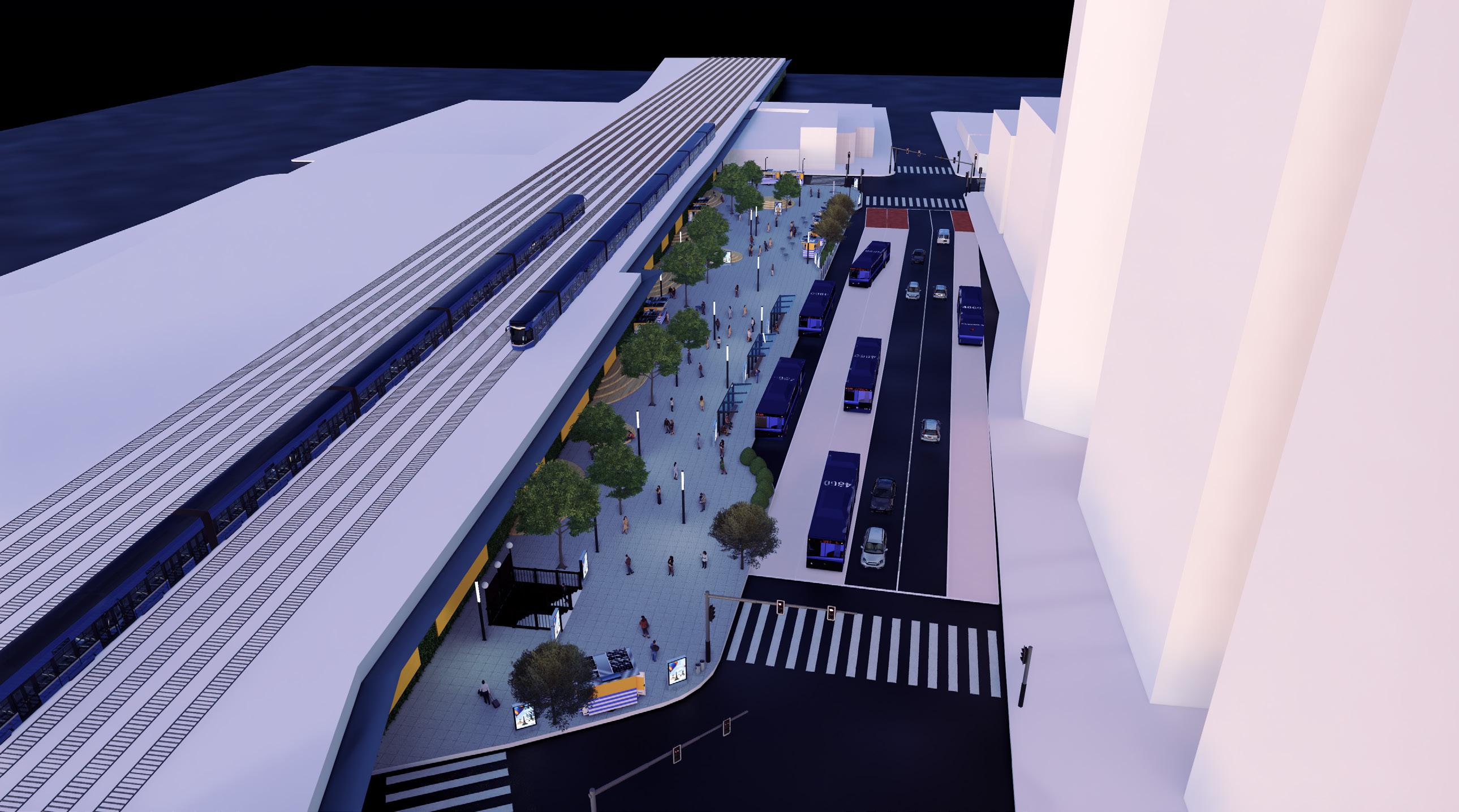
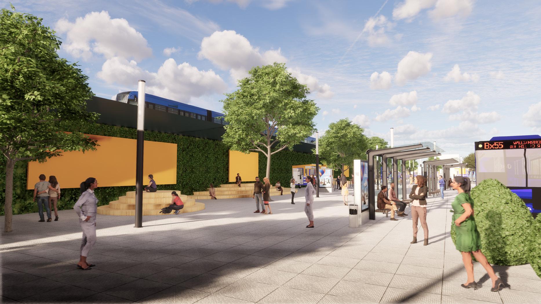
Option 1: Resilient Trasit Hub To enhance the resiliency aspects of the transit hub, features such as a tilted roof to collect and divert water to the green wall will be implemented. By doing this, water will not only be captured but reused within the same space. Some of this water will also be used to power the cooling misters located at the bus shelters at the newly adjusted bus stops. This will act as a method of cooling, especially as extreme heat days become more common. To improve the wayfinding capabilities, LinkNYC kiosks will be added to provide navigation information, charging ports and Wi-Fi for those waiting for extended periods of time. To ensure users are able to slow down and have multiple modes of seating, wide step-seating will be provided. Additional thought can be given to active programs that can occur in this space, such as farmer's markets or seasonal streets. This rendering highlights the increased shading the additional canopy can provide, along with the new placement of the bus stops which allow for more efficient pick-up and drop-off of passengers.
OPTION 1: RESILIENT TRANSIT HUB


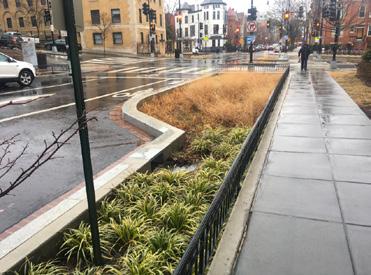
In proposal one, the transit as a public plaza with walking paths that allow interact with the space. the form of trees, bioswales, is to add not only a feature but also tranquility busy area. A green wall is to act as a water retention to dampen the vibrations overhead trains.
OPTION 1: RESILIENT TRANSIT HUB
OPTION 1: RESILIENT TRANSIT HUB
Proposal one transforms the transit hub into a user-friendly public plaza with curvilinear paths and green elements for tranquility. A green wall on the elevated railroad acts as both

Ovierview of features and programs of the Resilient Transit Hub. This
OPTION 01 CLIMATE RESILIENCE TRVANSIT HUB 37 Climate Resilience Neighborhood Studies: JAMAICA MOCEJ CRP 5172: NYC Urban Planning Workshop
RESILIENT TRANSIT
COOLING MISTER Railroad runoff collection flowing down to green wall Existing 20ft high elevated railroad + retaining walls below Roof/canopy providing shades + Concealing trains EV charging stations powered by solar microgrid for buses MTA Zero-emission bus Curvilinear sitting areas by the green wall Street lights enhancing safety issues Trash cans for better streetscape maintenance LINK NYC kiosk + Displays for real time arrival information
along the curb Green wall + Public art exhibitions Cooling misters toward bus lane to enhance urban heat effect Open plaza with local street vendors Existing bus lanes + routes Wide entrance near the street cross Wide entrance near the subway entrance + street cross Relocated bus stops with cooling misters on roofs GREEN WALL LINK NYC KIOSK LOCAL PUBLIC ART BIOSWALE
TRANSIT
Bioswale
RESILIENT
HUB
PROPOSED INTERVENTIONS 6 Climate Strong Communities: Inwood | MOCEJ CRP 5172: NYC Urban Planning Workshop
rendering
shading the
canopy
along
new
of the bus stops which allow for more efficient
of
highlights the increased
additional
can provide,
with the
placement
pick-up and drop-off
passengers.
Climate Strong Communities: Inwood MOCEJ CRP 5172: NYC Urban Planning Workshop
Climate Strong Communities: Inwood | MOCEJ
06
Option 2: Resilient Community Hub
Climate Resilience Neighborhood Strategy
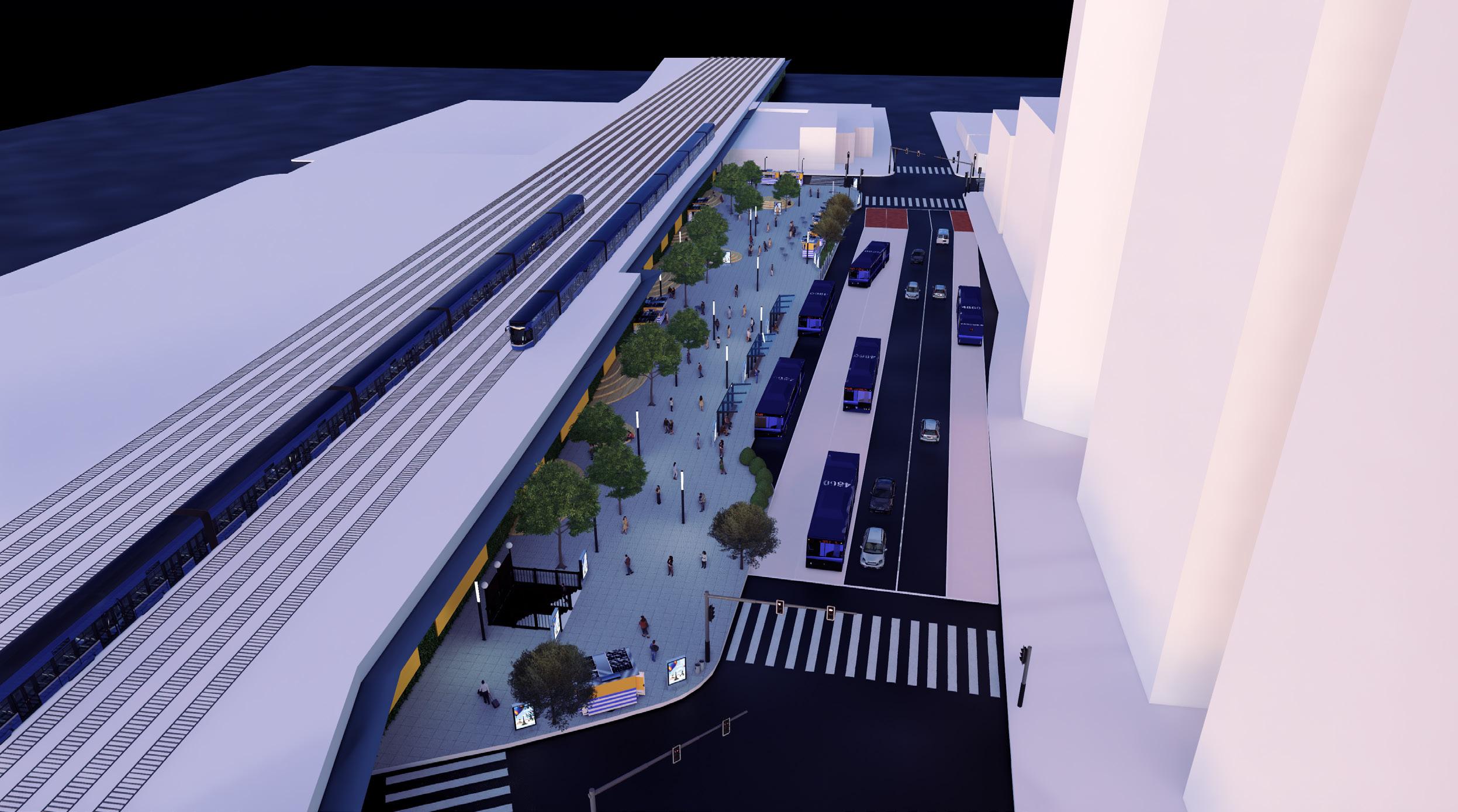
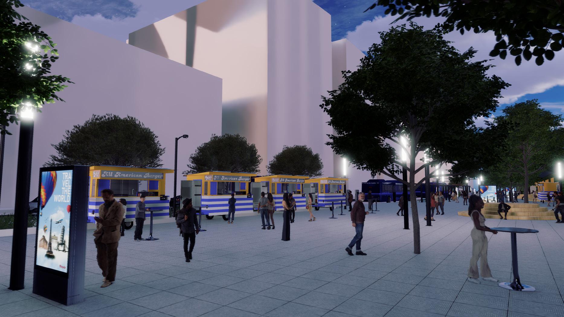
In conjunction with the resilient transit hub, the transit typology remains where bus stops are shifted to be located on Archer Avenue to ensure easier pick-up and drop-off. The creation of a building to provide cultural space filled with local public art and other services is essential for Jamaica's vision of turning the area into a cultural hub as was outlined in the Jamaica NOW! Plan. Similar elements as in option 1 are proposed including a green wall, LinkNYC kiosks, cooling misters, rain gardens, bioswales, solar-powered lamps, and more. In an effort to provide multiple community benefits, the resilient transit hub can be explored in a phasing method beginning with the redesign and implementation of resiliency strategies. Thus this will establish a cultural center offering access to social services, fostering resilience, sustainability, economic investment, and job creation.
OPTION 2: RESILIENT COMMUNITY CENTER RESILIENT


Ovierview of features and programs of the Resilient Community Hub.

The second phase entails establishing a cultural community center within the transit hub, offering residents access to facilities like job training and meeting areas. Exploring leasing opportunities to private businesses could be pursued for revenue generation.
OPTION 2: RESILIENT COMMUNITY
This rendering visualizes the potential of this center as an opportunity for food trucks, leisure strolls, and comfortable seating areas for those waiting for their buses to arrive.
OPTION
RESILIENT COMMUNITY CENTER RESILIENT COMMUNITY A second proposal and/or hub is to provide a cultural Within this space, residents to facilities such as job and more. The possibility to private businesses should avenue for revenue generation. COOLING MISTER Existing 20ft high elevated railroad + retaining walls below EV charging stations powered by solar microgrid for buses MTA Zero-emission bus Community center Public library + Conference hall + Job center + Daycare Street lights enhancing safety issues Trash cans for better streetscape maintenance LINK NYC kiosk + Displays for real time arrival information Bioswale along the curb Cooling misters toward bus lane to enhance urban heat effect Open space on the ground level Existing bus lanes + routes Wide entrance near the street cross Wide entrance near the subway entrance + street cross Glass walls on the ground floor Relocated bus stops with cooling misters on roofs GREEN WALL LINK NYC KIOSK COMMUNITY CENTER RUNOFF COLLECTION BIOSWALE
2:
COMMUNITY CENTER
conjunction with the resilient transit hub, the transit typology remains where bus stops are shifted to be located on Archer Avenue to ensure easier pick-up and drop-off. The creation of a building to provide cultural space filled with Climate Strong Communities: Inwood MOCEJ CRP 5172: NYC Urban Planning Workshop
In
07
SOLAR MICROGRID: OVERVIEW
Climate Resilience Neighborhood Strategy
MICROGRID: SUN STUDY
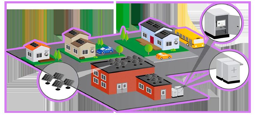
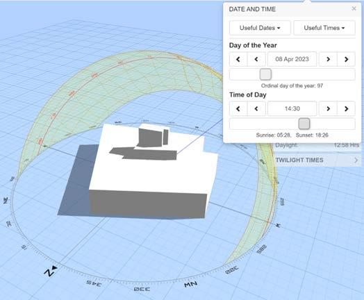
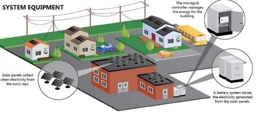
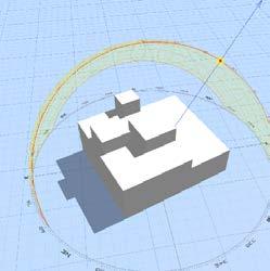
positioned on publicly owned structures, aligning with the city's commitment to carbon reduction through established initiatives such as the Clean Energy Program, overseen by the Department of Citywide Administrative Services. Functioning as a compact, localized energy system, the microgrid integrates solar power generation and battery storage to provide a sustainable and reliable electricity supply to the neighboring community. The implementation of the microgrid system holds numerous benefits for the city. Foremost, it stands to yield substantial financial savings, amounting to $825,238 annually. Beyond monetary gains, this initiative will significantly reduce the city's carbon footprint by 3,548,525 pounds of CO2 emissions per year. Despite the initial installation costs, the project showcasesa promising payback period. Without grants, it's estimated to take 8 years for the solar panels' generated savings to offset the setup expenses.

SOLAR MICROGRID: SUN STUDY

on publicly owned structures. utilization of established Clean Energy Program Department of Citywide Services, this undertaking
JAMAICA CENTER
SOLAR MICROGRID: OVERVIEW

Climate Strong Communities: Inwood | MOCEJ
CRP 5172: NYC Urban Planning Workshop
| MOCEJ
CRP 5172: NYC Urban Planning Workshop
the optimal amount of sunlight, a sun study building were impacted the most by shade. sunlight that can be absorbed by the solar
SOLAR MICROGRID: SUN STUDY
SOLAR

PUBLIC BUILDINGS THAT WILL HAVE NEWLY INSTALLED SOLAR PANELS
CRP 5172: NYC Urban Planning Workshop
Situated next to the resilient transit hub, the solar microgrid is strategically positioned on publicly owned structures. A visual representation has been thoughtfully integrated to illustrate the seamless assimilation of the proposed solar microgrid into the community
QUEENS COUNTY FAMILY COURT
Climate Strong Communities: Inwood | MOCEJ
QUEENS COUNTY FAMILY COURT
In order to ensure the solar panels absorb the optimal amount of sunlight, a sun study was conducted to see which areas of the building were impacted the most by shade. Shade significantly reduces the amount of sunlight that can be absorbed by the solar panels. It is important to note that peak sunlight typically occurs from 10 AM to 2 PM and this would where much of the solar power energy would be captured. Thus areas of the building that contained shade during these hours would be avoided in the placement of the solar panels.
QUEENS COUNTY FAMILY COURT
QUEENS COUNTY FAMILY COURT
Public buildings will strategically install newly installed solar panels to optimize solar power coverage. The image on the far right is the Social Security building whilst the central image is the Queens County Famiily Court. Finally the image on the far left is the NYPD Forensics Laboratory.
SOLAR MICROGRID
City's objectives to diminish and shift towards renewable visual depiction is included proposed solar microgrid into the community. Designed localized energy system, integrates solar power generation storage to supply electricity community. Monocrystalline affixed to three public buildings the microgrid with sustainable This endeavor is geared towards carbon footprint of the transportation
To ensure that these this strategy, the team to determine what sides the most sunlight to determine placing.
QUEENS COUNTY FAMILY COURT
QUEENS COUNTY FAMILY COURT
Situated next to the resilient solar microgrid is strategically on publicly owned structures. utilization of established Clean Energy Program administered Department of Citywide Services, this undertaking is City's objectives to diminish and shift towards renewable visual depiction is included to proposed solar microgrid seamlessly into the community. Designed localized energy system, the integrates solar power generation storage to supply electricity community. Monocrystalline affixed to three public buildings the microgrid with sustainable This endeavor is geared towards carbon footprint of the transportation
The existing solar panels Building will be smoothly microgrid system, ensuring supply to the community. microgrid surpass the main in terms of reliability and cost-effectiveness, it also collaborates with the provide electricity to the downtown
SUN STUDY
To ensure that this strategy, to determine the most sunlight
The existing solar panels on Building will be smoothly integrated microgrid system, ensuring supply to the community. microgrid surpass the main in terms of reliability and cost-effectiveness, it also collaborates with the provide electricity to the downtown
To ensure that these buildings were optimal for this strategy, the team conducted a sun analysis to determine what sides of the building received the most sunlight to determine the solar panel placing. The image on the far right is the Social Security building whilst the central image is the Queens County Famiily Court. Finally on the image on the far left is the NYPD Forensics Laboratory.
COST: $6,180,600 (not including state
IMPACT: The microgrid would generate would generate enough eletricity to
The Microgrid
solar on utilization
and
the This carbon
SOLAR Situated
Clean Department Services, City's
visual proposed into localized integrates storage community. affixed
D W mage Lands mage Lands mage Lands
SOLAR MICROGRID
Climate Strong Communities: Inwood
MICROGRID
Lands Image Lands Image Lands SOCIAL SECURITY BUILDING QUEENS COUNTY FAMILY COURT NYPD FORENSICS LABORATORY JAMAICA CENTER RESILIENT TRANSIT HUB
mage
mage Lands mage Lands mage Lands
COURT NYPD FORENSICS LABORATORY RESILIENT TRANSIT HUB
QUEENS COUNTY FAMILY
08
Waterscapes: Forming Community in Fi Di
Urban Design


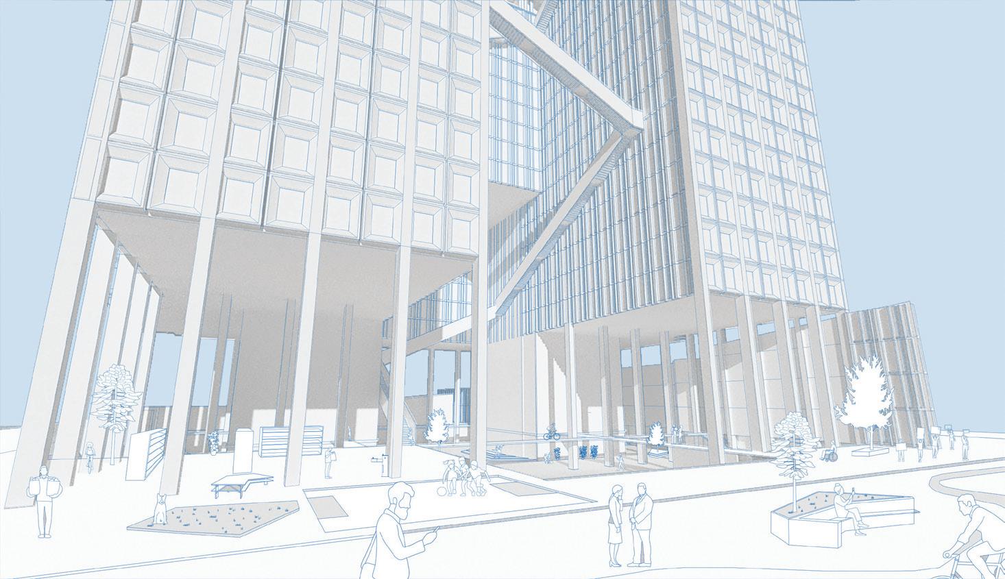
The area in front of the Battery Maritime Building (BMB) stands as a crucial gateway to the new East River esplanade, but its current layout creates a challenging pedestrian link between Battery Park and East River Park. With the convergence of the Battery Park Underpass tunnel entrance, a traffic turnaround, bus drop-offs, and traffic bound for Whitehall Terminal, the space in front of the BMB spans roughly one acre. The redevelopment of One York Plaza building will address this by relocating the tunnel entrance about 350 feet northeast, facilitating the creation of a new pedestrian plaza at the BMB entrance. This not only enhances traffic flow but also establishes a welcoming space for loading and unloading passengers, transforming the BMB into the gateway to Governors Island. The result is a public space that beckons residents, office workers, and visitors alike, providing an inviting destination along a route currently dominated by cars and a narrow


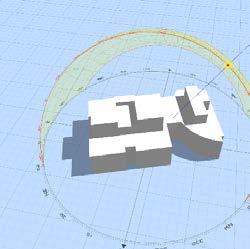
The proposed Waterscapes building located at the southern tip of the Financial District
Due to the high risk of flooding in the foreseeable future, it was imperative to improve the flood defense infrastructure in the immediate site. The proposed flood defense system comprises two levels: a lower one guarding the Financial District and Seaport by raising the shoreline (floodable during storms) and an upper level with 15-18 feet tall floodwalls. Floodgates are selectively used near the ferry terminals. The master plan advocates a blend of traditional and nature-based stormwater management. A pump station and pipes are suggested south of the Old Slip office building, minimizing conflicts and handling stormwater behind the defense. Green infrastructure, such as bioswales and permeable pavement, complements the pump station, managing stormwater before entering the sewer system.
1 NEW YORK PLAZA: WATERSCAPES BUILDING GAPS FILLING VOIDS FORMING COMMUNITY EXISTING BUILDING Building Information Date built: 1969 Height: stories Lot size: 111,382 sq Building size: 2,542,563 oor area: 1,887,925 sq Foot traffi 8,500 people per day Zoning C5-5, LM (High density offi locations) Commercial FAR: 15 Facility FAR: 15 Square feet over allowable area: 217,195 Site Plan: Interconnectivity Through Public Space BUILDING PROPOSAL Building Information Date completed: 2030 Height: 63 stories Lot size: 111,382 lot sq Building size: 1,899,000in lot sq Usable oor area: 1,887,925 Population: 2495 Zoning R10 (C5-5 equivalent) Residential FAR: 10 Commercial FAR: 15 Facility FAR: Square feet over allowable area: Ground Floor Plan: Embracing the Flood as Public Space Interconnectivity Diagram: Staten Island Governors Island and FIDI Resiliency Plan: Implementation with Proposal Site Plan: Interconnectivity Through Public Space Contextual Axonomteric: Financial District Southermost Point locations) 217,195 BUILDING PROPOSAL Building Information Date to be completed: 2030 Height: 63 stories Lot size: 111,382 in lot sq ft Building size: 1,899,000in lot sq ft Usable floor area: 1,887,925 sq ft Population: 2495 Zoning R10 (C5-5 equivalent) Residential FAR: 10 Commercial FAR: 15 Facility FAR: 15 Square feet over allowable area: Height: 50 stories Lot size: 111,382 in lot sq ft Building size: 2,542,563 in lot sq ft Usable floor area: 1,887,925 sq ft Zoning: C5-5, LM Residential FAR: 10 Contextual Axonomteric: Financial District Southermost Point. Site Plan: Interconnectivity Through Public Space. WATERSCAPES FORMING COMMUNITY BUILDING PROPOSAL Building Information Date to be completed: 2030 Height: 63 stories Lot size: 111,382 in lot sq ft Building size: 1,899,000in lot sq ft Usable oor area: 1,887,925 sq ft Population: 2495 Zoning R10 (C5-5 equivalent) Residential FAR: 10 Commercial FAR: 15 Facility FAR: 15 Square feet over allowable area: Height: 63 stories Lot size: 111,382 in lot sq ft Building size: 1,899,000in lot sq ft Usable floor area: 1,887,925sq ft Zoning: R10 (C5-5 equivalent) Residential FAR: 10 Waterscapes building.
10
One New York Plaza.
The section diagram illustrates the size of the proposed Waterscape building in comparison to well known buildings in Manhattan.

Program breakdown of the Waterscape site.


Programming In terms of programming, 75% of the space within the proposed Waterscape building will be allocated as residential, mostly catering to working class families with an average income ranging from $45,000 to $55,00. The proposal also aims to convert 10% of space within the Old New York Plaza building into Privately Owned Public Spaces (POPS). These outdoor areas provide opportunities for relaxation and socialization as well as outdoor amenities for recreational activities. Be it workers on lunch break, tourists between subway stations, midtown residents enjoying dinner, or anyone looking to step out of the busy streets, the proposal aims to designate thriving public spaces that are not constrained to the first five meters of the city. The community spaces, managed by the community association, will host diverse workshops and activities for residents and the public. A new non-profit organization will connect Manhattan, Staten Island, and Governors Island, facilitating dialogue and forming partnerships, including with Climate Exchange Stakeholders. The organization will provide valuable workshops, such as job training, financial literacy, and after-school education. Future residents are encouraged to access job training, including apprenticeships and English language skills. The proposal considers aquaculture apprenticeships within the job training program.


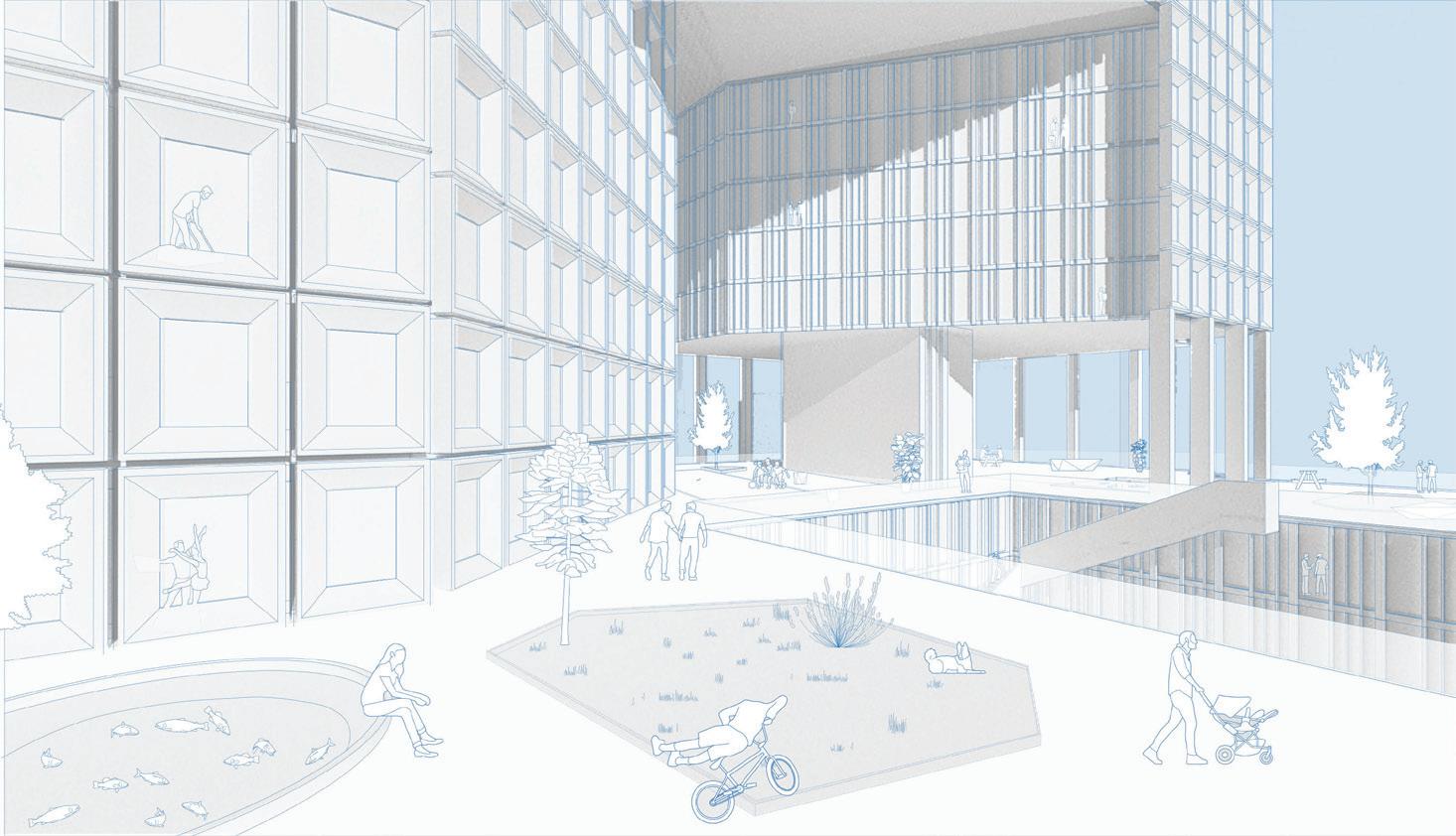
One superfloor is given over to outdoor green spaces and recreationional areas. A ground-level viewing window also allows the public to look into the research aquaculture floor.
A Building Section illustrating the building's important connection to wate.
Excavated public spaces at the building's base incorporate a lower platform and seating stairs, doubling as flood defense by capturing water and maintaining access with a platform bridge.
Food Waste stored degrees celcius freezer and then heated oven 40 edgrees 3-4 hour. Flies kept degree temperature and 65% humidity netted greenhouse. After 30 days the fly life cycle, black soldier flies the prepupae stage emerge from the greenhouse. These are then collected. Placed Oxen oven 60-100 degrees RSS water tanks closed aquculture systems where fish swim and feed. Minced meat placed plastic mixing tank. 2-3% industrial grade formic acid added mix. Sulphites added silage control oxidation and fungal growth chutes that travel down the building until reaching the food collection facility. 02 04 07 The dead fish collector system flushes out dead fish through bottom center drain Dead fish grinded 10-12TPH Grinder placed underneath RSS tank. pump Flour added to fish silage solidify then extruded pellets. Placed back into RSS 08 Black Solider Fly Dried Prepupae Aquaculture: Mechanics systems and Plans Building Section: Water Connection Residential Floor Plan: Living Across Scales Perspective: Public Space Above Perspective: Ground Floor Public Activation and Flood Adaptation Perspective: Ground Floor Public Activation and Flood Adaptation Ground Floor Plan: Embracing the Flood as Public Space RESIDENTIAL 75% PRIVATELY OWNED PUBLIC SPACE 10% AQUACULTURE 5% COMMUNITY 6% MAINTENANCE 4% Bedroom Bedroom Sports Barbecue Playground Tanks Pumps Plumbing Machinery Health Center Gyms Auditorium Assembly Hall Storage Solar Panels Program Breakdown Ground Floor Plan: Embracing the Flood Public Space RESIDENTIAL 75% PRIVATELY OWNED PUBLIC SPACE 10% AQUACULTURE 5% COMMUNITY 6% MAINTENANCE 4% Bedroom bedroom Bedroom Sports Gardens Barbecue Playground Tanks Pumps Plumbing Machinery Health Center Gyms Childcare Assembly Hall Storage Mechanical Solar Panels Program Breakdown Building Elevation: Void Penetration
11
Waterscapes: Forming Community in Fi Di
Proect Type: Dissertation
Subject: Suistainability
Understanding Sustainability in Clone Town Britain 03
Location: London, United Kingdom
Year: 2023-2024
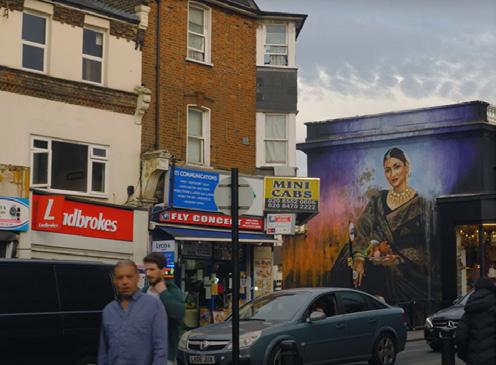
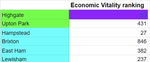
Context This paper investigates the relationship between Clone town scores and the economic, social, and environmental sustainability of six districts in London. The study pairs districts with similar socioeconomic conditions, labeling those with higher Clone town scores as Higher Clone town Score Town (HCST) and their counterparts as Lower Clone town Score Town (LCST). Over 400 surveys, 50 interviews, and ample amounts of data analysis from local databases were conducted to measure sustainability across these districts. Contrary to the New Economic Foundation's hypothesis in their Clone Town Britain Report, project findings show that LCSTs outperform HCSTs in economic vitality. Unsurprisingly HCSTs outperform their LCST counterparts in social sustainability due to strong community networks in these districts. Environmental sustainability was found to have no relationship to clone town scores. This research underscores the importance of understanding local dynamics and community engagement in promoting sustainable urban development across London's districts.
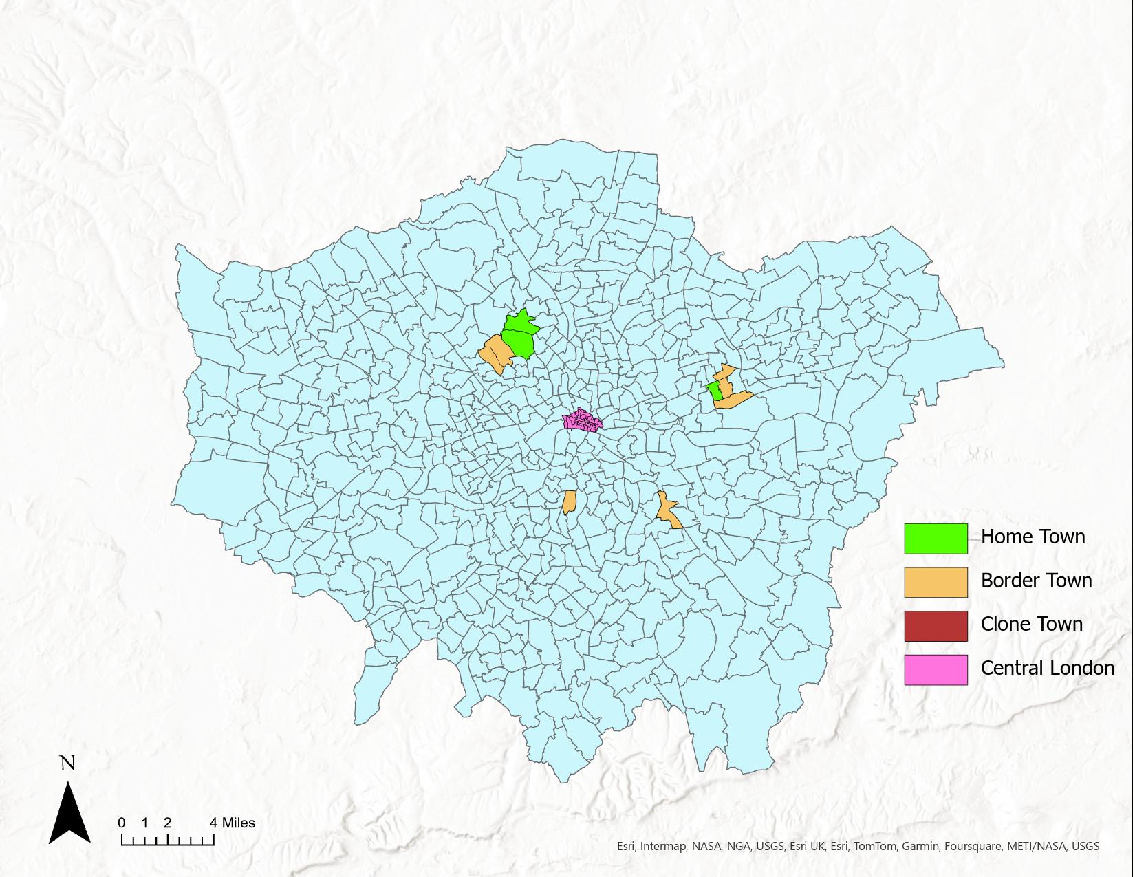
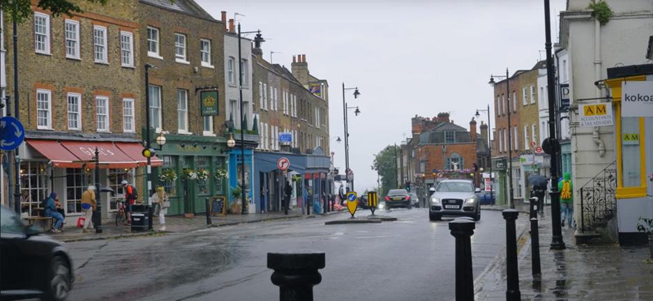
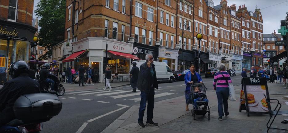
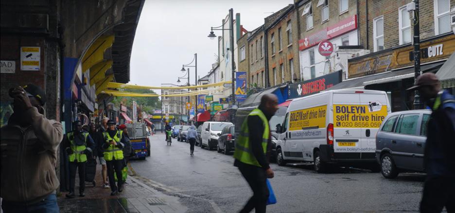
The analysis of London's high streets revealed a trend of traditional businesses closing down, leading to a loss of the city's unique character.
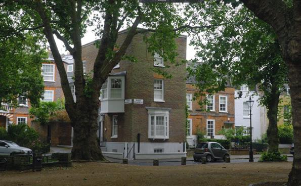
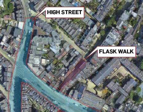
Highgate: Known its strong community networks and preservation efforts, with organizations like the Highgate Society playing a crucial role in maintaining local characteristics.
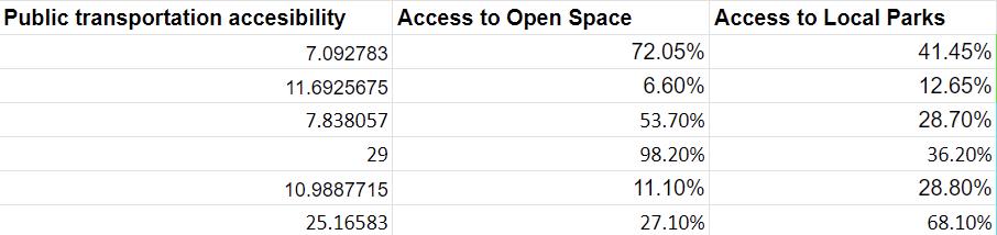
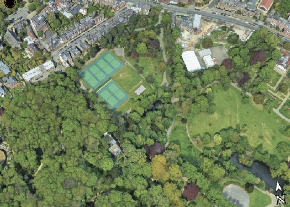
Hampstead: Famous for its Hampstead Heath, a protected green space that prevents development, ensuring residents have ample access to open areas.
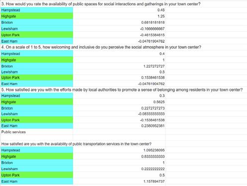
Brixton: Boasts Windrush Square, fiercely protected by local organizations, offering high accessibility to open spaces and parks for social interactions.
Lewisham: Residents express concerns about traffic affecting bus services, impacting their perception of public transportation accessibility negatively.
Upton Park: Faces challenges with public transportation accessibility, with residents experiencing dissatisfaction due to heavy traffic affecting bus services.
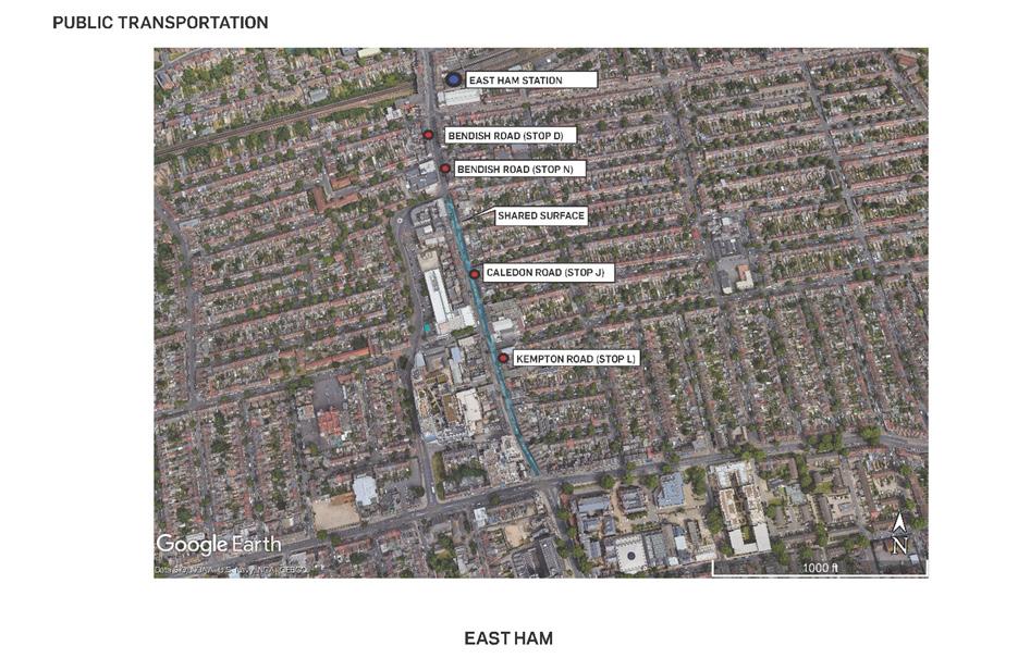
East Ham: Implements successful strategies like one-way shared spaces to improve transportation accessibility, leading to higher satisfaction among residents
13
Literature Review
a critical evaluation and synthesis of existing research and scholarship on a particular topic or research question
Social Sustainability Economic Sustainability Environmental Sustainability Understanding Sustainability in Clone Town Britain
First Space
capturing the built environment and its growth, form and function.
Second Space
explores how residents view the space around them
Third Space
explores how the first space and second place combines to illustrate a lived experience
Policy Recommendations
suggested actions to address specific issues or improve conditions within a community.
14
Social Sustainability Findings
Understanding Sustainability in Clone Town Britain

Community organizations such as the Highgate Society were often instrumenal in better preservation of local characteristic and higher participatory planning.
Economic Sustainability Findings
HCSTs scored lower in economical sustainability than LCSTs; high streets with more chain stores were more economically resilient to rising rents across London.
Environmental Sustainability Findings
Local history, rather than a town's clone town's score, influence its residents access to open spaces and parks.
Community hubs, which are comprised of library and a town hall, often facilitated community activities and often led to social inclusion.
Traditional indoor markets are struggling to stay afloat in modern day London. Many hawkers and business owners are fearful of being made vacant due to the high rents.
The level of affluence in a district significantly influences its ability to protect public services and maintain neighborhood character from changes imposed by developers.
Successful districts with traditional stores were often organized and collectively communicated their concerns to local government.
Transportation accessibility is influenced by a town's history and residents' perceptions, rather than its clone town score
Traffic congestion significantly affects residents' satisfaction with public transportation. Traffic jams lead to slower speeds for buses.
15
Axi Corridor: Reimagining Woolwich 04
Proect Type: Planning Studio
Subject: Urban Renewal
CORRIDOR AXI
Location: Woolwich, London
Year: 2022-2023
CORRIDOR AXI
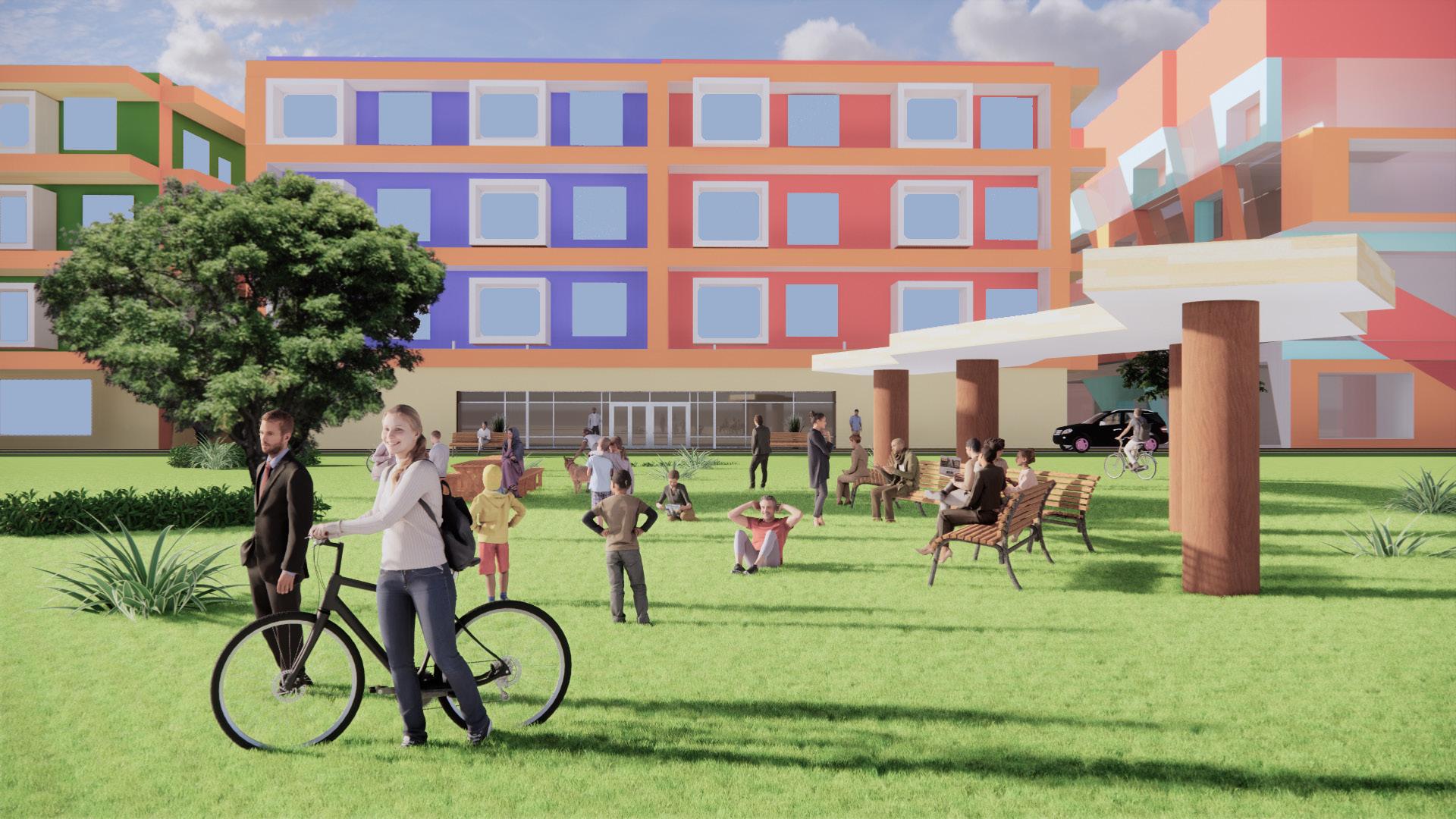
Axi Corridor, a 22-acre sustainable site in Woolwich, South East London, revitalizes while preserving diversity. Its mixed-use buildings, affordable housing, and public spaces promote social cohesion.This innovative project sets a precedent for urban renewal and sustainability.
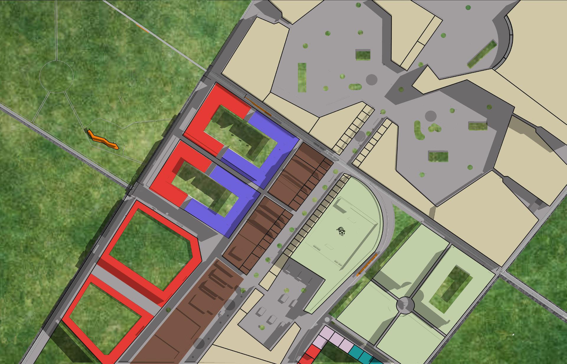

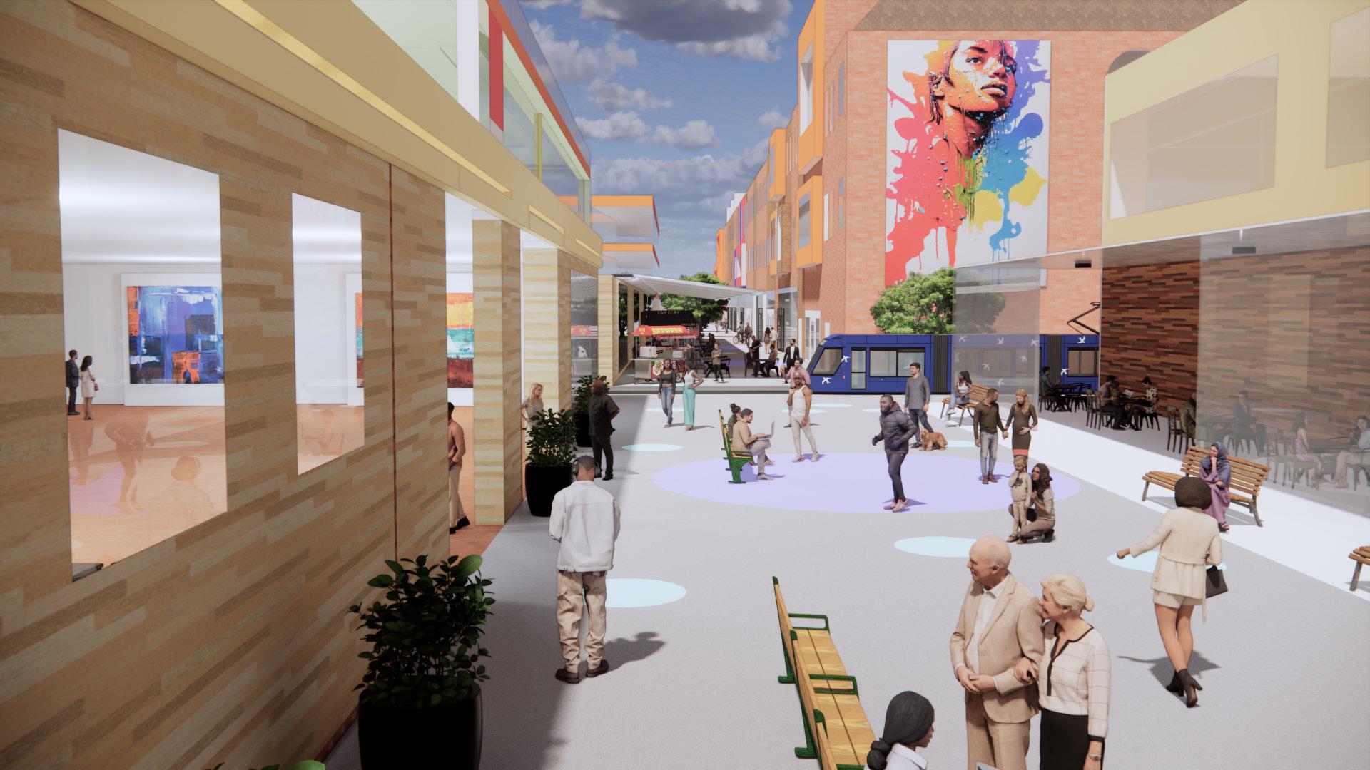
Corridor Stretching through the middle of the site is a long pedestrianized high street known as Corridor. This high street contains an endless number of places to shop, congregate, work, learn all within a 2 minute walk to the DLR tram line. The new Enterprise Trading Center, which sits in the middle of the corridor, contains a diverse range of dining options and over hundred retail spaces for local small businesses to set up shop. Its rooftop will also contain a 5 aside football court which will be great space for residents to participate in casual football games and tournaments. Nearby, the Sea Square space will contain a small street market offering affordable prices to local residents.
Stretching through the middle of the site is a long pedestrianized high street known as Corridor. This high street contains an endless number of places to shop, congregate, work, learn all within a 2 minute walk to the DLR tram line. The new Enterprise Trading Center, which sits in the middle of the corridor, contains a diverse range of dining options and over hundred retail spaces for local small businesses to set up shop. Its rooftop will also contain a 5 aside football court which will be great space for residents to participate in casual football games and tournaments. Nearby, the Sea Square space will contain a small street market offering affordable prices to
Stretching through the middle of the site is a long pedestrianized high street known as Corridor. This high street contains an endless number of places to shop, congregate, work, learn all within a 2 minute walk to the DLR tram line. The new Enterprise Trading Center, which sits in the middle of the corridor, contains a diverse range of dining options and over hundred retail spaces for local small businesses to set up shop. Its rooftop will also contain a 5 aside football court which will be great space for residents to participate in casual football games and tournaments. Nearby, the Sea Square space will contain a small street market offering affordable prices to
Corridor Stretching through the middle of the site is a long pedestrianized high street known as Corridor. This high street contains an endless number of places to shop, congregate, work, learn all within a 2 minute walk to the DLR tram line. The new Enterprise Trading Center, which sits in the middle of the corridor, contains a diverse range of dining options and over hundred retail spaces for local small businesses to set up shop. Its rooftop will also contain a 5 aside football court which will be great space for residents to participate in casual football games and tournaments. Nearby, the Sea Square space will contain a small street market offering affordable prices to local residents.
Running through the heart of the site is Corridor, an extensive pedestrianized high street. Offering a myriad of shopping, socializing, working, and educational opportunities, all within a mere 2-minute stroll to the DLR tram line, Corridor epitomizes convenience. At its nucleus lies the Enterprise Trading Center, boasting a diverse array of dining establishments and over a hundred retail spaces, providing an ideal platform for local small businesses to establish themselves. Moreover, atop the Center, a 5-aside football court awaits, providing residents with a recreational space for casual matches and tournaments. Adjacent to this, Sea Square will host a compact street market, catering to the needs of local residents at affordable prices.
Corridor Stretching through the middle of the site is a long pedestrianized endless number of places to shop, congregate, work, learn all within Center, which sits in the middle of the corridor, contains a diverse businesses to set up shop. Its rooftop will also contain a 5 aside casual football games and tournaments. Nearby, the Sea Square local residents.
Axi Corridor is a hypothetical 22-acre site designed as an exercise in sustainable development and urban renewal. Sitting in the industrial district of Woolwich in South East London, Axi Corridor seeks to revitalize and empower a forgotten section of London whilst preserving its diversity and character. Named after its ‘axe’ shaped frame, Axi Corridor will contain an eclectic array of mixed-use buildings, affordable housing, public spaces, parks and services located in its revitalized new high street. Its combination of human scaled buildings and narrow pathways mimics that of an urban village which will benefit social cohesion and cultural mixing amongst its residents. Sitting inside a major transportation hub, Axi Corridor will be served by the DLR electric tram which runs throughout the site and will allow residents to reach Central London in under thirty minutes. This development will also contain green roofs and constructed wetlands in order to reduce the risk of urban flooding in a neighbourhood that has had devastating floods in the past.
Axi Corridor is a hypothetical 22-acre site designed as an exercise in sustainable development and urban renewal. Sitting in the industrial district of Woolwich in South East London, Axi Corridor seeks to revitalize and empower a forgotten section of London whilst preserving its diversity and character. Named after its ‘axe’ shaped frame, Axi Corridor will contain an eclectic array of mixed-use buildings, affordable housing, public spaces, parks and services located in its revitalized new high street. Its combination of human scaled buildings and narrow pathways mimics that of an urban village which will benefit social cohesion and cultural mixing amongst its residents. Sitting inside a major transportation hub, Axi Corridor will be served by the DLR electric tram which runs throughout the site and will allow residents to reach Central London in under thirty minutes. This development will also contain green roofs and constructed wetlands in order to reduce the risk of urban flooding in a neighbourhood that has had devastating floods in the past.
birds eye view of Axi Corridor: A Transit Oriented Development lying in the industrial neighbourhood of Woolwich.
Canopy Large amounts of parkland await those seeking a refreshing reconnection with nature. Large amounts of green space will stretch across the site allowing for residents to go on walks, exercise or barbecue with their family and friends. The constructed wetland known as the Canopy in the southwestern section of the site will help absorb any excessive amount of rainwater which has increasingly plagued this part of London with flooding. Green Roofs located in many rooftops
Campus The site will contain a diverse range of community centers and services in its interconnected public spaces in order to empower the greater community as well educate them on the issues of sustainability. The new Emerald library located in the Campus
Center
Axi Corridor is a hypothetical 22-acre site designed as an exercise in sustainable development and urban renewal. Sitting in the industrial district of Woolwich in South East London, Axi Corridor seeks to revitalize and empower a forgotten section of London whilst preserving its diversity and character. Named after its ‘axe’ shaped frame, Axi Corridor will contain an eclectic array of mixed-use buildings, affordable housing, public spaces, parks and services located in its revitalized new high street. Its combination of human scaled buildings and narrow pathways mimics that of an urban village which will benefit social cohesion and cultural mixing amongst its residents. Sitting inside a major transportation hub, Axi Corridor will be served by the DLR electric tram which runs throughout the site and will allow residents to reach Central London in under thirty minutes. This development will also contain green roofs and constructed wetlands in order to reduce the risk of urban flooding in a neighbourhood that has had devastating floods in the past.
Canopy Large amounts of parkland await those seeking a refreshing reconnection with nature. Large amounts of green space will stretch across the site allowing for residents to go on walks, exercise or barbecue with their family and friends. The constructed wetland known as the Canopy in the southwestern section of the site will help absorb any excessive amount of rainwater which has increasingly plagued this part of London with flooding. Green Roofs located in many rooftops within the site also help to absorb any excess amount of rainwater.
also occupy these spaces so that residents can enjoy international cuisines during their breaks.
Canopy provides parkland for outdoor activities, with a wetland mitigating flooding and green roofs aiding in water absorption for sustainability. options.
Axi Corridor is a hypothetical 22-acre site designed as an exercise in sustainable development and urban renewal. Sitting in the industrial district of
Campus The site will contain a diverse range of community centers and services in its interconnected public spaces in order to empower the greater community as well educate them on the issues of sustainability. The new Emerald library located in the
Canopy Large amounts of parkland await those seeking a refreshing reconnection with nature. Large amounts of green space will stretch across the site allowing for residents to go on walks, exercise or barbecue with their family and friends. The constructed
any excess amount of rainwater.
Campus features diverse community centers to educate the community on sustainability, including the Emerald library which possesses cutting edge educational and event spaces.
Campus The site will contain a diverse range of community centers and services in its interconnected public spaces in order to empower the greater community as well educate them on the
within the site also help to absorb any excess amount of rainwater. Campus The site will contain a diverse range of community centers and services in its interconnected public spaces in order to empower the greater community as well educate them on the
of sustainability. The new Emerald library located in the Campus section
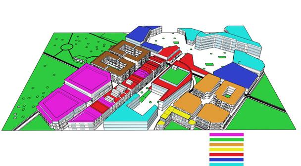
Corridor will contain over 10,000 books, 3 new educational spaces and 4 new event spaces to ensure the diverse needs of residents are met. Food trucks and market stalls also occupy these spaces so that residents can enjoy international cuisines during their breaks. The Enterprise Trading Center Aside Football Pitch Sea Square Emerald Library Canopy 2 3 4 100 200 300 Tram Line Tram Stop Two-way Street Bike Lane Collection Node Green Infrastructure Main Spine Public High density residential Parks and open space Commercial retail Office Medium density residential Low density residential Mixed-use
Lancelot Comrie CRP 5861| Fall 22
issues
of Axi
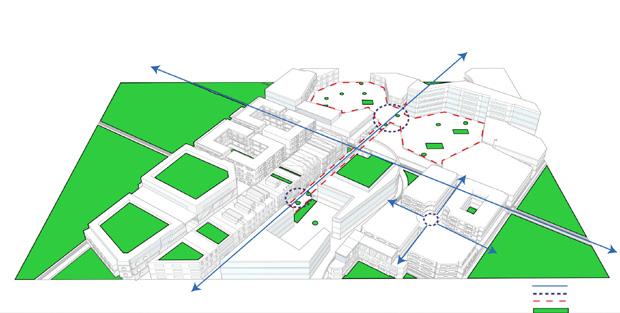
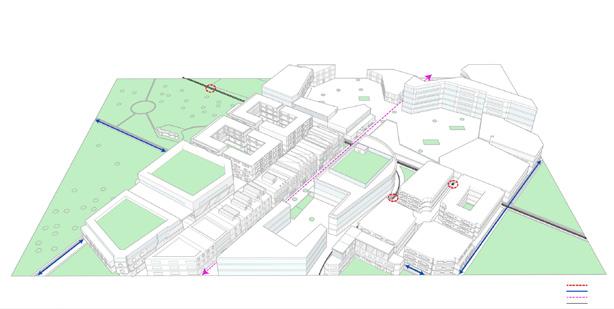
Land Use Framework Circulation Birds Eye View
1 Corridor Campus The Enterprise Trading Center Aside Football Pitch Sea Square Emerald Library Windrush Center Canopy 2 3 4 5 6 7 8 6 8 100 200 300 Land Use Framework Circulation Birds Eye View
urban renewal. Sitting in the
of London whilst preserving its
and
affordable housing, public spaces, parks and
industrial district
diversity
character.
Square
7
Emerald Library Windrush
Canopy 7 8
Aside
Sea
Emerald
Windrush Center Canopy 2 3 4 5 6 7 8 1 2 5 6 7 100 200 300
1 Corridor Campus The Enterprise Trading Center
Football Pitch
Square
Library
stalls
1 Corridor Campus The Enterprise Trading Center Aside Football Pitch Sea Square Emerald Library Windrush Center Canopy 2 3 4 5 6 7 8 1 2 3 4 5 6 7 8 100 200 300 Tram Line Tram Stop Collection Node Public Office Land Use Framework Circulation Birds Eye View
section of Axi Corridor will contain over 10,000 books, 3 new educational spaces and 4 new event spaces to ensure the diverse needs of residents are met. Food trucks and market
also occupy these spaces so that residents can enjoy international cuisines during their breaks.
CORRIDOR AXI A
A series of diagrams showing the community being visualized across different lenses within urban design.
16
