PRÉFACE D’ÉRIC LAGADEC
ASTROPHYSICIEN


PRÉFACE D’ÉRIC LAGADEC
ASTROPHYSICIEN
ENSEIGNANT CHERCHEUR
L’OBSERVATOIRE
Né à Sizun (Finistère) en 1980
Vulgarisateur | Auteur
Le Finistère est un petit coin de paradis de la nature situé, comme son nom l’indique, à la pointe de la péninsule bretonne. J’ai eu la chance d’y grandir avant de migrer vers la Côte d’Azur pour y découvrir l’astronomie. Laurent Laveder a fait le chemin inverse : il a passé son enfance dans les Alpes-Maritimes avant de s’installer au bout du monde pour, notamment, y photographier le ciel étoilé.
Quand on parle du Finistère, on pense généralement à la fin de la Terre et au début de l’immensité de la mer. Les photos de Laurent, mêlant la beauté des paysages finistériens et de la voûte céleste, nous rappellent que ce lieu est également une superbe porte d’entrée vers l’immensité de l’Univers. En tant qu’astronome, j’aime rappeler aux gens que lever les yeux vers le ciel est une source d’émerveillement constant. En tant qu’astronome finistérien, grâce à ce livre, je peux maintenant rappeler que dans le Finistère, les splendeurs visuelles se trouvent dans toutes les directions : Terre, Mer et Univers.
Éric Lagadec, astrophysicist / The Finistère is a little corner of paradise located, as its name suggests, at the tip of the Breton peninsula. I was lucky enough to grow up there before migrating to the French Riviera to discover astronomy. Laurent Laveder lived the opposite: he spent his childhood in the French Riviera before settling at the edge of the world to, most notably, photograph the starry sky.
When we talk of the Finistère, we generally think of the end of the Earth and the start of the infinite sea. Laurent’s photos, mixing the beauty of the Finistère’s landscapes and the celestial arch, remind us that this place is also a fantastic entryway to the immensity of the Universe. As an astronomer, I like to remind people that raising their gaze to the sky is a constant source of wonderment. As an astronomer from the Finistère, thanks to this book, I can now remind them that in the Finistère, the visual splendours are found in all directions: Earth, Sea, and Universe.
« [...] in the Finistère, the visual splendours are found in all directions: Earth, Sea, and Universe.»
POINTE DU VAN OCÉAN ATLANTIQUE
POINTE DU RAZ
PENTREZ
LOCRONAN PLOMODIERN
POULLANSUR-MER TRÉBOUL DOUARNENEZ
AUDIERNE PLOGOFF
PONT-CROIX
PORS POULHAN
SAINT-GUÉNOLÉ LA TORCHE TRÉGUENNEC PLOVAN
Summary / 9 paths towards the sky of the Southern Finistère. QUIMPERLÉ CLOHARS-CARNOËT KERFANY PONT-AVEN NÉVEZ
P. 4 > 7 | AVANT-PROPOS
P. 8 > 19 | DU POULDU À PONT-AVEN
P. 20 > 33 | DE NÉVEZ À CONCARNEAU
P. 34 > 45 | DE FOUESNANT À BÉNODET
P. 46 > 59 | DE QUIMPER À SAINTE-MARINE
P. 60 > 71 | DE L’ÎLE-TUDY À LOCTUDY
P. 72 > 83 | DE LESCONIL À PENMARC’H
P. 84 > 97 | DE SAINT-GUÉNOLÉ À AUDIERNE
P. 98 > 109 | DE PLOGOFF À POULLAN-SUR-MER
P. 110 > 123 | DE TRÉBOUL À PENTREZ
P. 124 > 125 | RÉALISATION D’UN PANORAMA
P. 126 > 127 | TRAITEMENT LIGHTROOM FRANCE
Avant de vous lancer dans la lecture de cet album photo, je souhaite vous aider à en comprendre les images. Car comment ne pas croire que l’astre orangé qui se couche est le Soleil, avec sa couleur caractéristique d’un coucher de Soleil et le ciel bleu plus haut comme si la journée touchait à sa fin ?
Le quiproquo provient de la perception de nos yeux qui se montrent peu performants la nuit lorsque la lumière vient à manquer. Nous voyons alors avec la périphérie de notre rétine, une zone riche en cellules photosensibles (les « bâtonnets ») capables de détecter la lumière, mais pas d’en voir la couleur. La nuit n’est donc pour nous qu’un monde noir et blanc, et seules les lumières vives de lampadaires ou des enseignes publicitaires demeurent colorées.
Before launching into reading this photo album, I would like to help you understand the images first. Because how could one not believe that the setting orange object is the Sun, with its characteristic colour of a Sunset and the blue sky above, as if the day were ending? The misunderstanding comes from the perception of our eyes that prove to perform poorly at night when the light level is low. We see then from the periphery of our retina, a zone rich in photosensitive cells (called “rods”) capable of detecting light, but not to see colour. The night is therefore for us just a black and white world, and only bright streetlights or advertisements remain colourful.
La réalité est tout autre. Un appareil photo numérique, qui n’a pas nos limites biologiques, perçoit tout avec acuité. La Lune qui se couche en pleine nuit est orange comme un Soleil, et le ciel, illuminé par la lumière blanche de l’astre sélène, se révèle bleu. Ce phénomène appelé « diffusion Rayleigh » est à l’origine du rougissement des astres proches de l’horizon et de la couleur bleue du ciel.
DIGITAL PHOTOGRAPHY REVEALS REALITY!
Reality is something else. A digital camera, without our biological limitations, perceives everything with accuracy. The Moon setting in the dark of night is orange as the Sun, and the sky, illuminated by the white light of the celestial body, comes out blue. This phenomenon named the “Rayleigh diffusion” is at the origin of the reddening of the stars close to the horizon and the blue colouring of the sky.
OUR EYES / DIGITAL PHOTOGRAPHY / INTERPRETATION / ONLY REALITY / THE LIGHT / NIGHTSCAPE
«To the naked eye [...] only the Moon seemed to have a colour!»
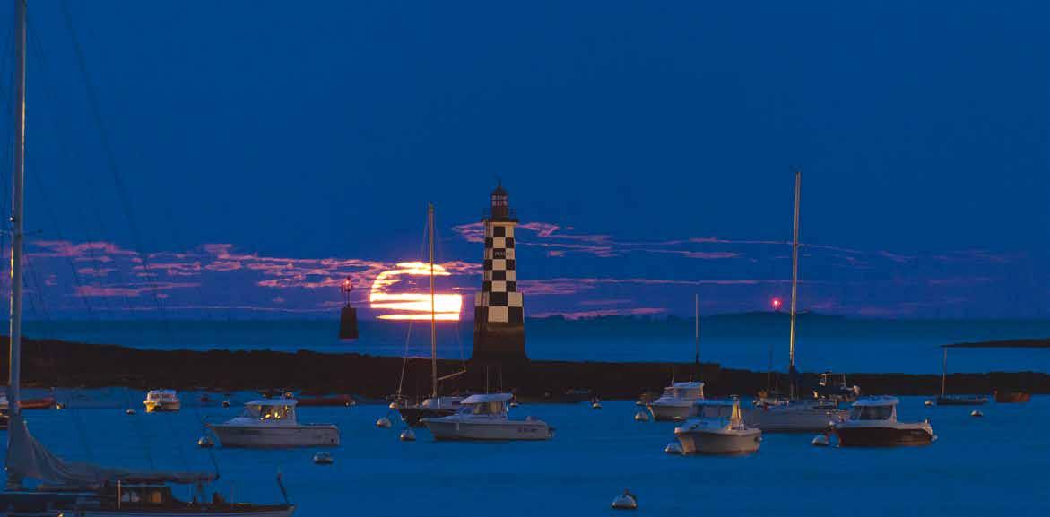
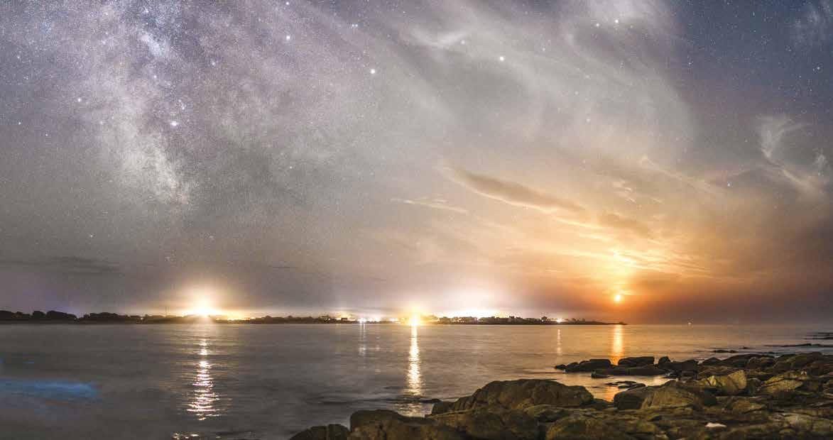
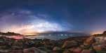
Ces préalables posés, décryptons une photo piégeuse (ci-dessous). À droite, le Quartier de Lune qui se couche est orange et le ciel est bleuté. Tout à gauche, le port du Guilvinec déploie un grand halo orange. Dans l’océan, des vagues bleues révèlent la présence de bioluminescence due au plancton phosphorescent. Des lumières ponctuent l’horizon.
De droite à gauche, nous voyons la lumière blanche du port de Saint-Guénolé, la source lumineuse orange
With these prerequisites set, let’s decrypt a tricky photo (below). To the right, the setting Quarter Moon is orange and the sky is blue. At the left, Le Guilvinec port deploys a big orange halo. In the ocean, blue waves reveal the presence of bioluminescence due to phosphorescent plankton. Some lights punctuate the horizon. Right to left, we can see the white light of Saint-Guénolé port,
d’une paillote, puis le phare d’Eckmühl jaunâtre et au-dessus du plancton, les phares d’une voiture. Dans le ciel, la Voie lactée se dresse à la verticale avec un voile de cirrus à sa droite.
À l’œil nu, je n’ai perçu que la lueur diffuse de la Voie lactée, tout comme je détectais à peine la lueur pâle incolore du plancton. Et si je voyais toutes les lumières artificielles, elles n’étaient pas colorées. Seule la Lune m’apparaissait en couleur !
the orange light source of a straw hut, then yellowy Eckmühl lighthouse, and above the plankton, car headlights. In the sky, the Milky Way stands vertical with a cirrus cloud veil to its right. To the naked eye, all I could see was the diffuse glow of the Milky Way, just as I could barely see the pale discoloured glow of the plankton. And if I saw all the artificial lights, they weren’t coloured. Only the Moon seemed to have a colour!
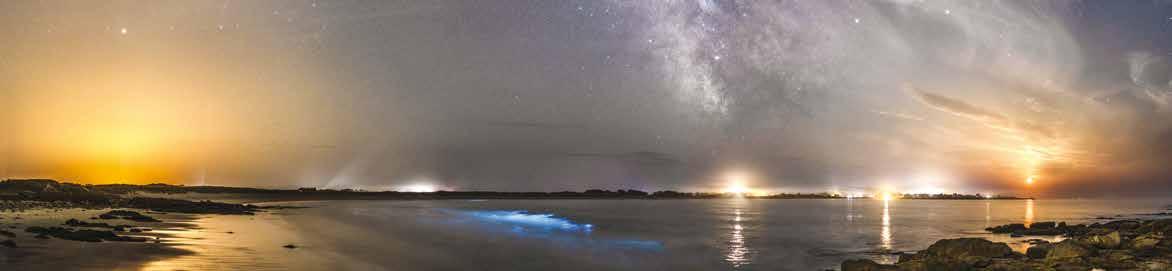
23/08/2023 | 23:35 | 50 mm | F/1.4 | 6 s | 1600 ISO LA TORCHE > DE LA BIOLUMINESCENCE À PORS CARN
Peu avant le coucher de la Lune, le ciel est bien bleu et bien sombre. Parfait pour la Voie lactée. À droite, les lumières de Port Manec’h.
Kerfany Beach / Shortly before the Moonset, the sky is very blue and very dark. Perfect to see the Milky Way. On the right, the lights of Port Manec’h.
47˚48’13.7566” N 3˚31’37.6601” W
17/04/2024 | 05:30 | 24 mm | F/2.0 | 1/4 à 10 s | 1600 ISO
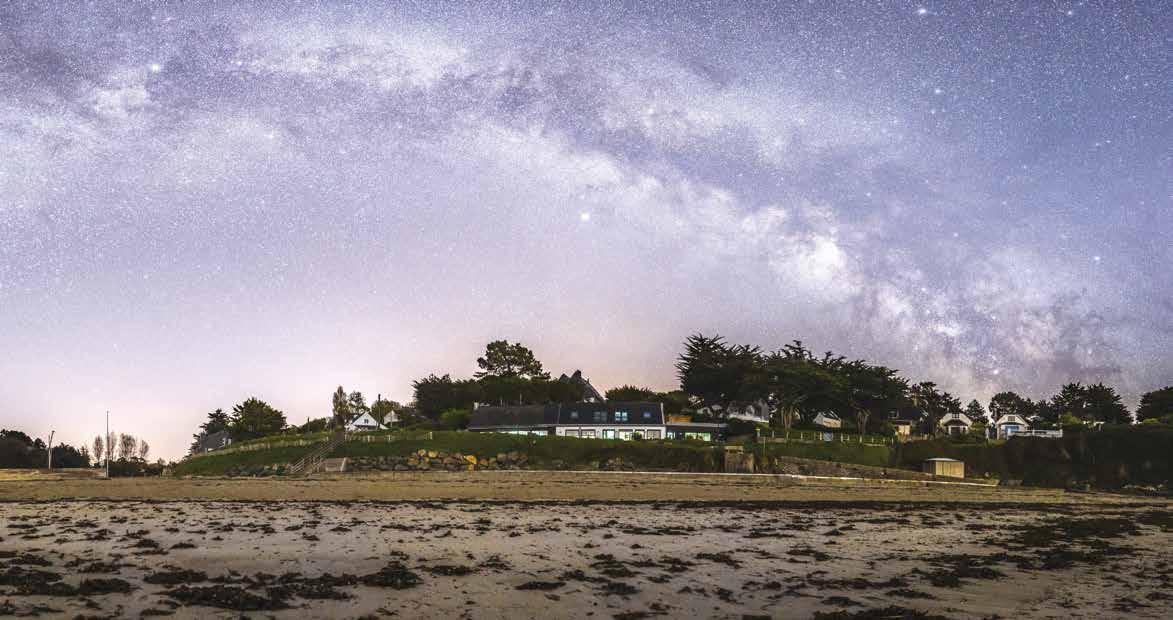
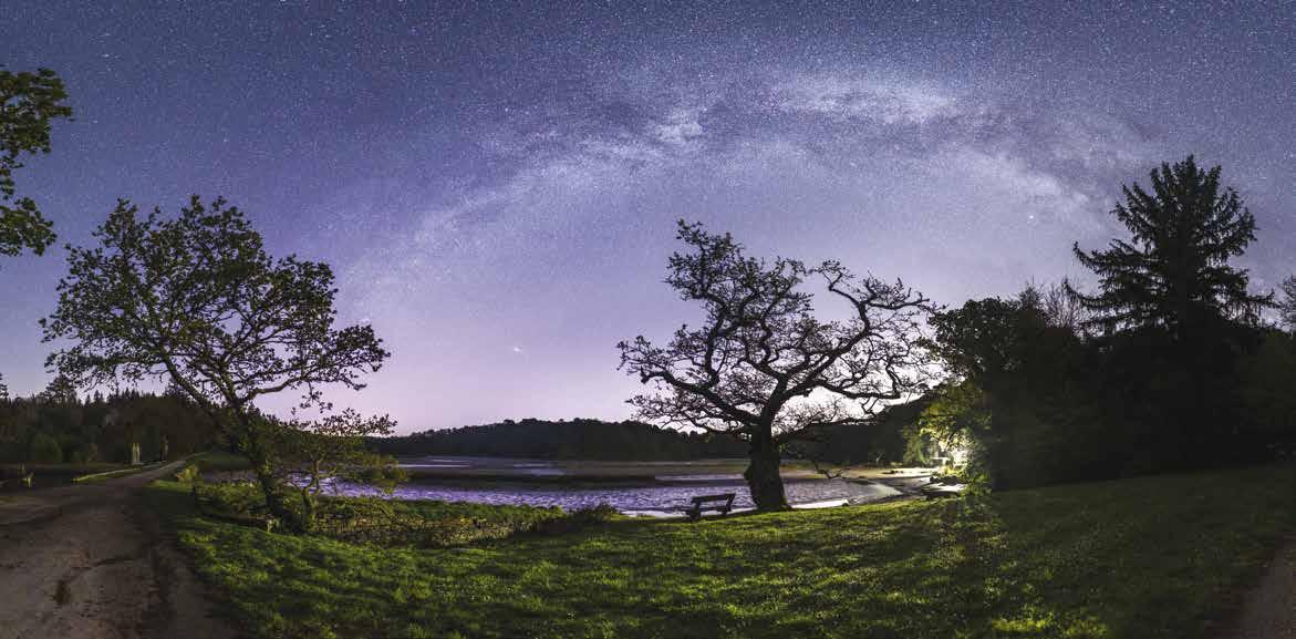
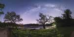
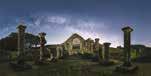
Le magnifique chêne pédonculé (élu « arbre de l’année » en 2024) au bord de la Laïta sous l’arche de la Voie lactée.
Saint-Maurice Abbey / The gorgeous English oak tree (voted “tree of the year” in 2024) along the Laïta River below the arch of the Milky Way.
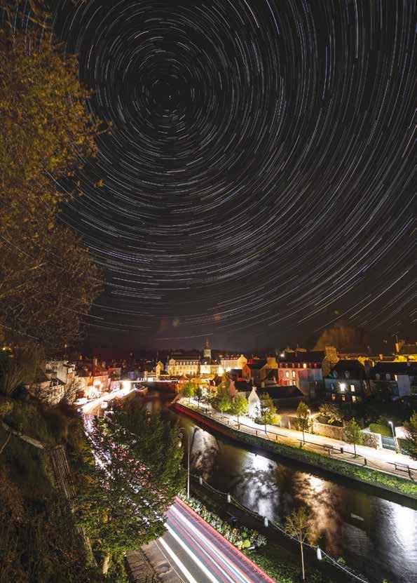
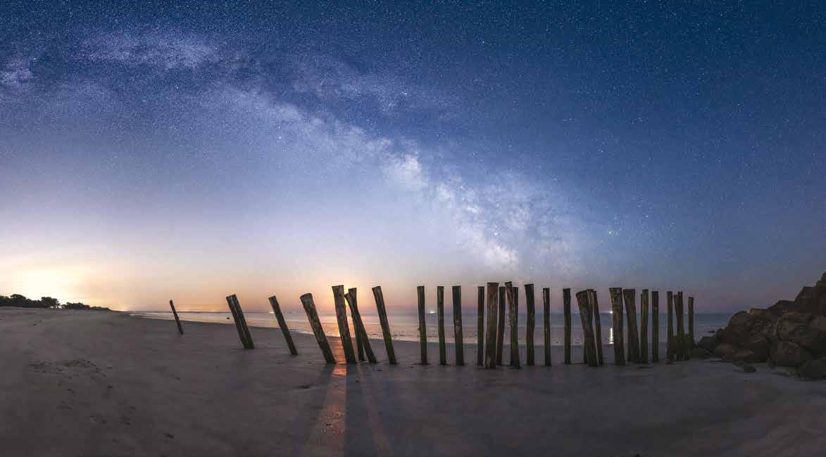
Une heure de pose suffit aux étoiles à tracer des arcs de cercle de 15° de long tandis que des voitures laissent des traces blanches et rouges en bas à gauche.
Star trails above the Laïta River / A one hour exposure time allows the stars to move circularly by 15° as cars leave white and red trails on the lower left.
47˚46’7.58” N 3˚35’15.72” W
18/04/2023 | 00:00 > 01:00 16 mm | F/8 |120x30 s | 200 ISO
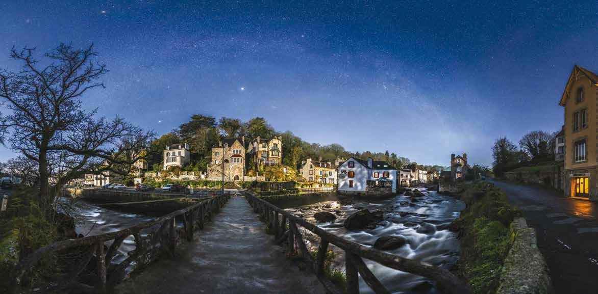
En janvier, c’est la Voie lactée d’hiver qui enjambe la rive droite de Pont-Aven en direction de l’ouest. Les maisons de maître accrochées aux flancs des collines sont caractéristiques du charmant petit bourg. La lumière ne saurait être plus favorable avec la Lune dans mon dos levée depuis une heure à peine et une lanterne orangée devant le Moulin du Grand Poulguin.
The right bank of the Aven river / In January, it’s the Winter Milky Way that spans the right bank of Pont-Aven towards the West. The mansions clinging to the hillsides are characteristic of this charming little town. Le light could not be more favourable with the Moon behind me having risen just an hour prior and an orange tinted lantern in front of the Grand Poulguin Mill.
En mai, c’est en se tournant vers l’est que je trouve la Voie lactée d’été au-dessus de la rive gauche de la rivière Aven. La Lune étant cachée par les arbres, c’est le flash de mon smartphone qui éclaire le pont et le reste du paysage.
The left bank of the Aven river / In May, it is by turning to the East that I find the Summer Milky Way above the left bank of the Aven River. The Moon is hidden by the trees, and it’s the flashlight from my smartphone that lights up the bridge and the rest of the landscape.
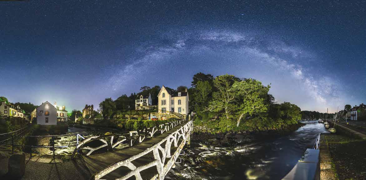
47˚51’11.2126” N 3˚44’51.6119” W
12/05/2023 | 04:20
24 mm | F/2.0 à 4.0 | 1/4 à 10 s | 1600 ISO
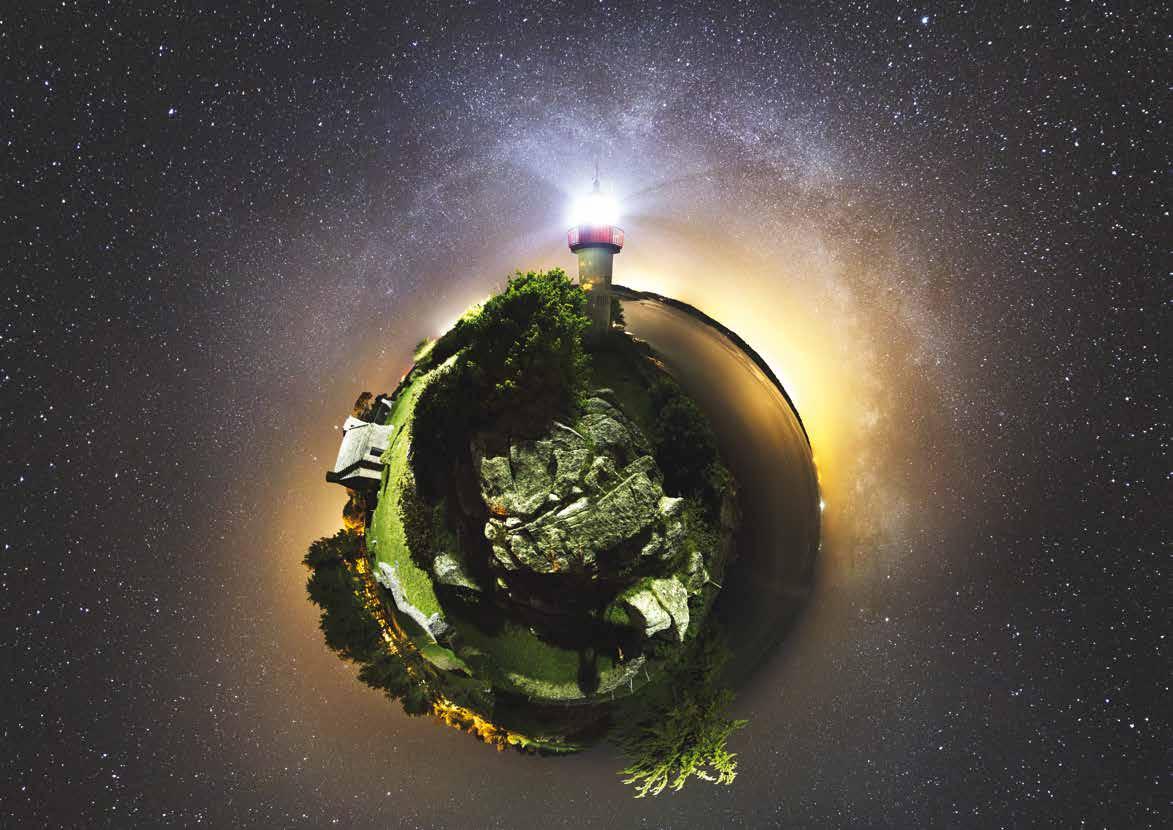
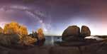
Cette projection à 360° de type « Petite planète » ressemble à l’astéroïde du Petit Prince.
Port Manec’h as a “little planet” / This “little planet” 360° projection reminds of the asteroid from The Little Prince.
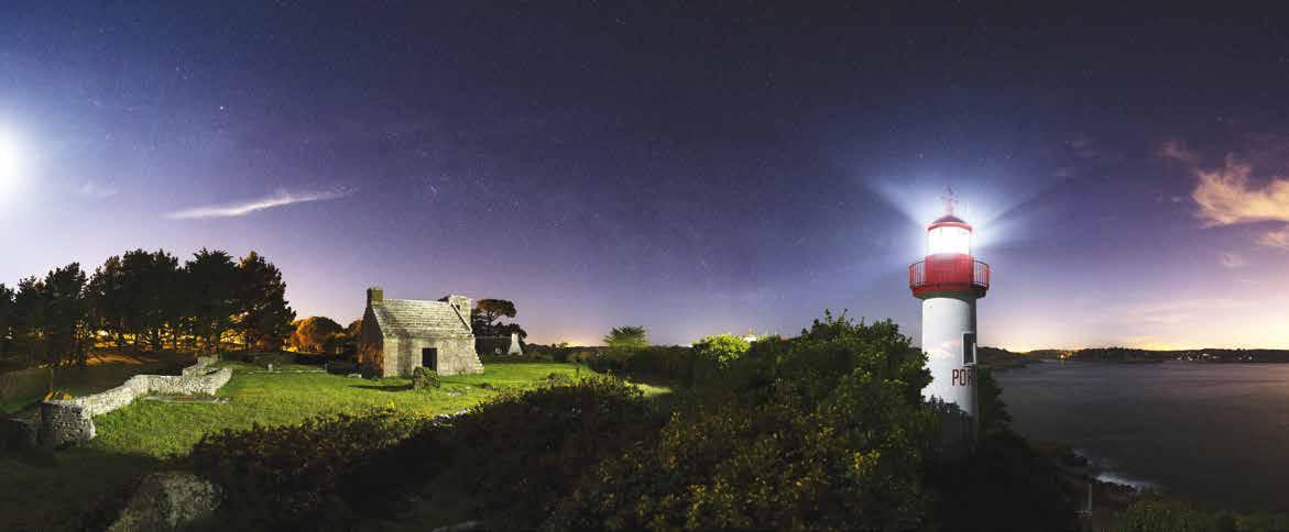
Le phare éclaire la pelouse comme en plein jour, tandis que la Lune (hors champ tout à gauche) illumine le pied du phare et donne au ciel cette belle teinte bleue qui contraste avec les couleurs orangées des villes de Quimperlé et Lorient (tout à droite). Encore une preuve qu’une belle lumière vaut mieux que plus d’étoiles.
Port Manec’h lighthouse / The lighthouse illuminates the grass as in broad daylight, while the Moon (out of frame to the left) illuminates the foot of the lighthouse and gives the sky this beautiful blue tint which contrasts with the orange colors of the towns of Quimperlé and Lorient (on the far right). Another case proving that good lighting is worth more than more stars.
L’antenne rouge du sémaphore teinte le sable, tandis que Concarneau à gauche et le Pays Bigouden (à droite) déploient leur halo orangé. Mais la Lune contrebalance avec ce beau ciel bleu. Quelques bateaux et deux phares (Penfret en rouge et Les Moutons en blanc) rythment l’horizon.
Dune and Kermyl beaches / The semaphore’s red antenna tints the sand, while Concarneau (left) and the Bigouden Country (right) deploy their orange halos. However, the Moon counterbalances these lights with this beautiful blue sky. A few boats and two lighthouses (Penfret in red and Les Moutons in white) punctuate the horizon.
47˚51’3.264” N 4˚1’18.792” W
03/05/2021 | 04:10
Le timing est parfait ! La Lune en Quartier (cachée au centre par des pieux) à peine levée dessine la silhouette des poteaux, mais sans masquer la Voie lactée dans un ciel bleuté. Les oppositions de couleurs (avec notamment Concarneau tout à gauche) sont superbes !
Cleut Rouz beach / The timing is perfect! The barely risen Quarter Moon draws the silhouettes of the posts while hiding behind them, but without masking the Milky Way in a blue sky. The opposing colours (thanks to Concarneau to the left) are superb!
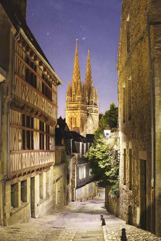
La rue du Lycée qui descend jusqu’à la Place au Beurre est le plus beau point de vue sur la ville. La pollution lumineuse permet tout de même d’entrevoir la Voie lactée et quelques nébuleuses (telle la Nébuleuse de la Lagune juste à droite du coq au sommet de la flêche).
Quimper’s most beautiful view / Lycée street which goes down towards the Place au Beurre is the most beautiful view in the city. The light pollution doesn’t completely obscure the Milky Way nor a few nebulae (such as the Lagoon Nebula to the right if the cockerel).
47˚59’51.71” N 4˚6’12.97” W
23/06/2018 | 01:00
50 mm | F/4.0 | 1/4 à 4 s | 1600 ISO
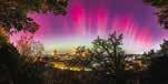
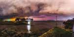
L’intense aurore boréale d’octobre 2024 m’a permis de tenter une photo inédite en pleine ville. De subtils faisceaux lumineux se déploient dans la fenêtre ouverte entre les arbres, avec la cathédrale en contrebas.
Aurora Borealis from Frugy / The intense Aurora Borealis of October 2024 enabled me to attempt an unseen photo in the city centre. Subtle beams of light unfold in the open window between the trees, with the cathedral below.
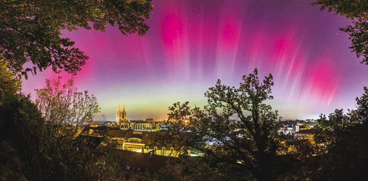
47˚59’37.206” N 4˚6’1.698” W
11/10/2024 | 01:15 | 24 mm | F/2.0 | 4 s | 400 ISO
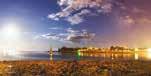
La Lune qui se lève à gauche parvient à contrebalancer la teinte orangée du paysage pollué par la lumière du port de Bénodet.
The Milky Way above the port / The rising Moon to the left counterbalances the orange-tinted landscape, polluted by the light from Bénodet port.
En masquant un gros projecteur du port de Bénodet, je suis parvenu à neutraliser la teinte orange (voir photo de la page précédente). Les bâtiments et l’arbre remarquable sont mis en avant à l’aide du flash de mon smartphone. À droite, un nuage à la verticale de Quimper se teinte d’orange. Enfin, les étoiles typiques du ciel d’hiver (Orion, le Taureau et les Pléiades) se mirent dans les eaux lisses du charmant petit port, surmontées par la Voie lactée.
The winter sky in the port’s waters / By masking a large light source from Bénodet port, I can neutralise the orange tint (see left page). The buildings and the remarkable oak are emphasised with the help of the flashlight on my smartphone. To the right, a cloud above Quimper is tinted orange. The stars, typical of a Winter sky (Orion, Taurus, and the Pleiades) are mirrored in the smooth waters of this charming little port, surmounted by the Milky Way.
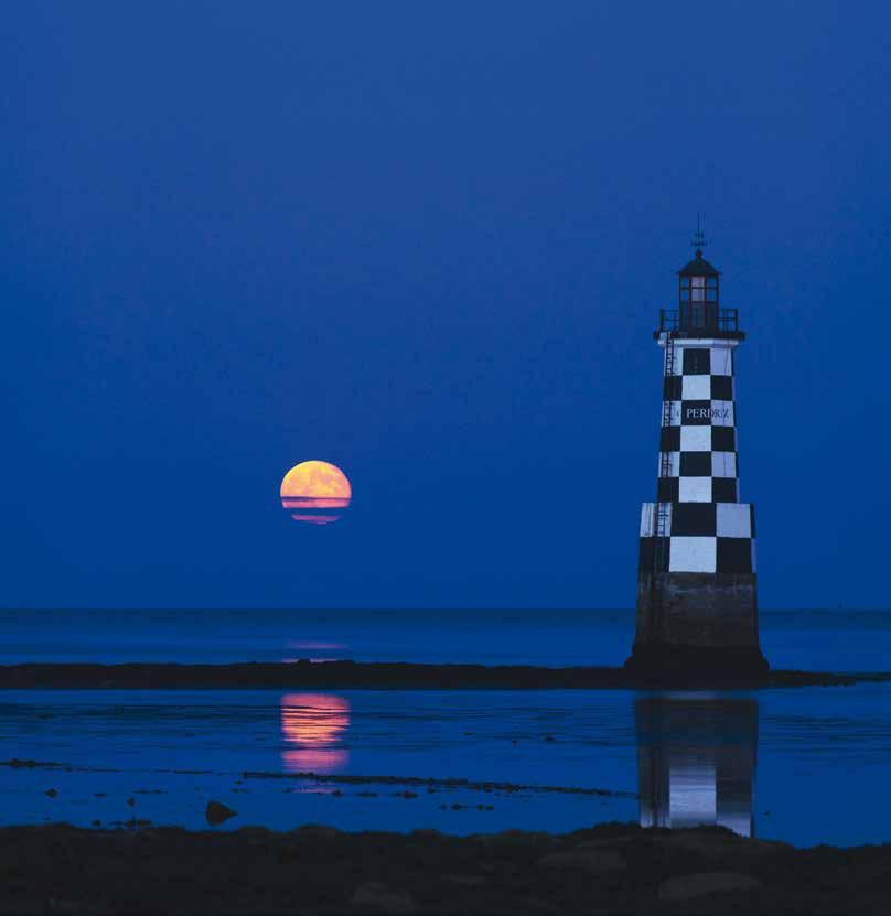
À l’heure bleue (une heure tardive du crépuscule où les teintes orange du coucher du Soleil ayant disparu, le ciel majoritairement bleu colore tout en bleu), ciel et paysage se teintent d’une couleur froide que seule la Pleine Lune réchauffe. L’opposition du cercle lunaire et du damier est très graphique.
Perdrix Turret / In the blue hour (a late hour of twilightwhere the orange tints of the Sunset have disappeared, the sky majority blue tints everything in blue), sky and landscape are painted by a cold colour that only the Full Moon brings warmth to. The juxtaposition of the lunar circle and of the checkerboard is very graphic.
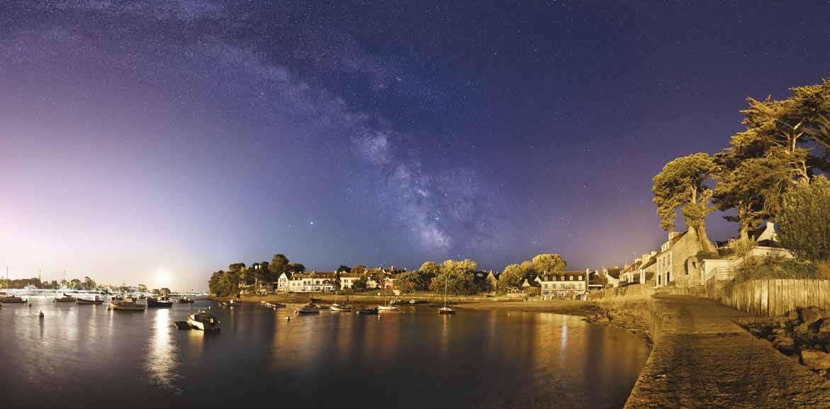
Quand le crépuscule est encore plus avancé que la photo précédente, les lumières provenant de l’Île-Tudy et Loctudy colorent alors les bateaux et la Tourelle des Perdrix. D’ailleurs, le ciel bleu n’est pas bleu ! Il s’agit de nuages teintés par le crépuscule à l’heure bleue. Remarquez à droite la lumière rouge du phare de l’Île aux Moutons.
View from Garo Island / When twilight is even more advanced than the previous photo, the orange streetlights from Île-Tudy and Loctudy colour the boats as well as Perdrix Turret. In fact, in reality, the blue sky is not blue! Those are rather clouds, tinted by the twilight at the blue hour. Notice on the right the red light from the Sheep Island lighthouse.
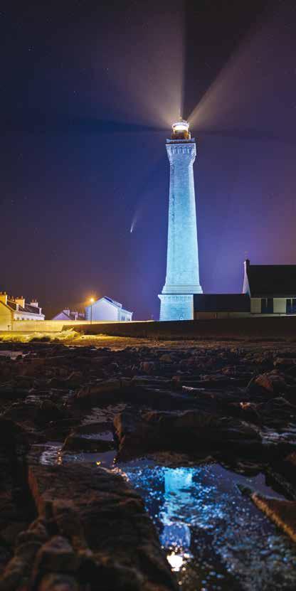
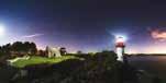
Par réflexe, je me place de telle sorte que le phare se reflète dans un trou d’eau, prolongeant ainsi sa silhouette élancée. Mais si je suis là, c’est pour profiter de la présence de la comète NEOWISE qui m’offre l’opportunité de photographier l’édifice sous cet angle, en direction du nord-ouest, là où le ciel est habituellement sans intérêt. L’opposition de couleurs orange/bleu est très esthétique.
Eckmühl Lighthouse and Comet NEOWISE / By reflex, I stand so that the lighthouse reflects in a pool of water, prolonging its elongated silhouette. The reason I am here in the first place is to make the most of the Comet NEOWISE , which offers me the opportunity to photograph this building in this angle, towards the North-West, where the sky is usually uninteresting. The opposition of the orange and blue colours is very aesthetically pleasing.
47˚47’50.7183” N 4˚22’19.8596” W
19/07/2020 | 00:20 50 mm | F/2.0 | 1/4 à 4 s | 1600 ISO
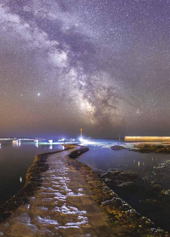
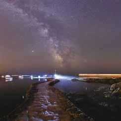
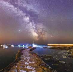
À quelques pas du lieu de prise de vue de la photo de gauche, je tourne maintenant le dos au phare pour faire face à la Voie lactée. Quelques pêcheurs au bout de la cale m’offrent une lumière rasante idéale qui révèle le relief de ce chemin qui mène aux cieux. Les lampadaires au pied d’Eckmühl teintent la digue en orange.
Saint-Pierre slipway / Just a few steps from where I took the photo on the left page, I turn my back to the lighthouse to face the Milky Way. Some fishermen at the end of the slipway provide an ideal low-angled light that reveals the relief of this path that leads to the heavens. The streetlights at the foot of Eckmühl give the seawall an orange hue. 47˚47’48.5648” N 4˚22’25.4407” W
19/07/2020 | 00:55 24 mm | F/1.4 | 13 s | 6400 ISO
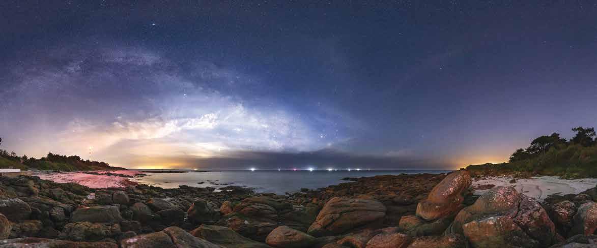
La lumière sublime ce paysage vide et plat. À gauche, nous pouvons voir l’orange du Guilvinec, puis le bleu du plancton phosphorescent, suivi du phare d’Eckmühl et de la paillote « Chez Marie-Cath », et enfin la lumière blanche du Port de Saint-Guénolé et la Lune en Quartier orangée.
Bioluminescence at Pors Carn / The light makes sublime this wide and flat landscape. To the left, the orange from Le Guilvinec, then blue from phosphorescent plankton, followed by Eckmühl lighthouse, by «Chez Marie-Cath», and finally the white light of the Saint-Guénolé port and the orange Quarter Moon.

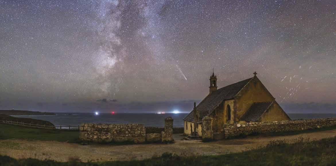
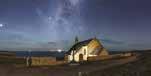
La Lune dans mon dos illumine le paysage et projette mon ombre sur le mur (à gauche) tandis que mon smartphone caché au pied du calvaire met en valeur la chapelle. Des phares (de gauche à droite, La Vieille, La Plate, Sein et Ar Men) et l’Île de Sein ponctuent l’horizon.
Saint-They Chapel / The Moon behind me lights up the landscape and projects my shadow onto the wall (left), while my smartphone, hidden at the foot of the statue, highlights the chapel. Some lighthouses (left to right: La Vielle, La Plate, Sein, and Ar Men) and Sein Island punctuate the horizon.
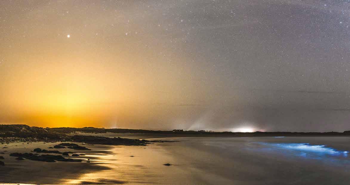
En l’absence de lumière, le paysage est nettement moins bien mis en valeur. Mais dans le ciel, outre la Voie lactée et la comète Tsuchinshan-ATLAS, de nombreux satellites Starlinks situés à 45° à la verticale du Soleil réfléchissent sa lumière dans ma direction, les rendant bien visibles pendant une bonne dizaine de secondes. J’efface habituellement les traces laissées par les satellites, mais ici, ils deviennent un phénomène lumineux à part entière.
Milky Way, comet and Starlinks / In the absence of light, the landscape is significantly less showcased. But in the sky, besides the Milky Way and Comet Tsuchinshan-ATLAS, numerous Starlink satellites situated at 45° vertical of the Sun reflect its light in my direction, making them very visible for a dozen seconds. I would normally erase trails left by satellites, but here, they become a special luminous phenomenon worthy of interest.
48˚3’36.306” N 4˚42’41.958” W
25/10/2024 | 22:40
50 mm | F/1.4 | 6 s | 3200 ISO
This is the ultimate step! The one that will reveal my photo! Technically, this is the easyest step.
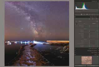
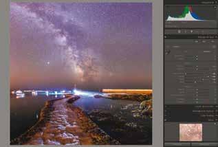
Photo brute qui contient déjà tout le nécessaire.
Mais il faut faire en sorte que tout ce qui est utile soit bien visible.
The initial file contains all the necessary information. But we have to make sure the most useful elements are clearly visible.
Réduction des hautes lumières et éclaircissement des ombres (généralement, Hautes lumières à -100 et Ombres à +100).
Reducing highlights and revealing details in the shadow (usually, Highlights at -100 and Shadows at +100).
Amplification des blancs et réduction des noirs (Blancs poussés à +55 et Noirs diminués à -15).
C’est à cette étape qu’on sait si la photo est réussie !
Boosting White and Reducting Black (Whites to +55 and Blacks to -15). At this step, we know if the photo is good!
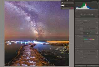
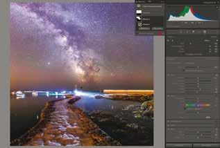
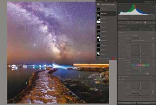
Retouche globale du ciel (dégradé linéaire sur le ciel avec amplification des Blancs +20, diminution des Noirs -30 et Clarté +10).
Global manual editing in the sky (linear gradient for the sky with Whites at +20, Blacks at -30 and Clarity at +10).
Retouche locale sur la Voie lactée (Pinceau sur la Voie lactée avec amplification des Blancs +20, diminution des Noirs -10 et Clarté +30).
Local manual editing on the Milky Way (Brush on the Milky Way with Whites to +20, Blacks to -10 and Clarity to +30).
Retouches locales pour dynamiser les détails (contraste plus fort sur la cale, réduction de la luminosité des pêcheurs, débouchage en bas à droite, correction d’une zone du ciel trop sombre, etc.).
Local manual editing to boost details (stronger contrast to the slipway, lower brightness of fishermen, lighting up on the lower right, correction of an area of the sky that is too dark, etc.).
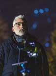
Laurent Laveder est un (astro)photographe professionnel qui partage 3 passions : l’astronomie, la photo et le Finistère (par ordre d’apparition dans sa vie !).
Il en fait la synthèse dans cet ouvrage, véritable hommage à la beauté et à la diversité des paysages finistériens ! Le livre est structuré en 9 territoires qui rythment le Finistère Sud, du Pouldu à Pentrez. Laurent choisit des sites uniques, avec un paysage particulier qui permet de capturer une photo exceptionnelle !
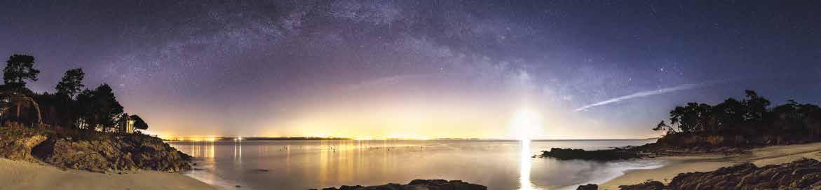
La qualité du ciel est remarquable en Finistère. Du fait d’un urbanisme maîtrisé, les nuits sont bien sombres et les étoiles parfaitement visibles. Mais la beauté d’une photo ne se mesure pas à la quantité d’étoiles présentes… C’est avant tout la qualité de la lumière qui fait la différence !
Et c’est là que Laurent se distingue avec près de vingt ans d’expérience dans le « nightscape » (la photo de paysage de nuit). Il sait quand, où et comment trouver la lumière qui sublimera ses paysages. Le Finistère, avec sa côte très découpée, ouvert sur tous les points cardinaux, donne ainsi accès à tous les phénomènes astronomiques : la Voie lactée d’été ou d’hiver, un lever ou un coucher de Lune, une aurore boréale... En somme, c’est en Finistère (littéralement « La fin de la Terre ») que commence le ciel !
Ce premier volume consacré au Finistère Sud sera suivi d’un autre tome dédié au Finstère Nord d’ici 2027.
Laurent Laveder is a professional (astro)photographer who shares three passions: astronomy, photography, and the Finistère (by order of appearance in his life!). He synthesises these in this piece, a true homage to the beauty and diversity of the Finistère’s landscapes! The book is structured in 9 territories that punctuate the Southern Finistère, from Le Pouldu to Pentrez. Laurent chooses unique locations, with a particular landscape that enables to capture exceptional photos!
The sky’s quality is remarkable in the Finistère. Thanks to a controlled urbanism, the nights are very dark and the stars perfectly visible. But the beauty of a photo isn’t measured by the quantity of stars present… It is mainly the quality of the light that makes the difference!
And it’s here that Laurent distinguishes himself, with close to 20 years’ experience in “nightscape” photography (photographing landscapes and the sky at night). He knows when, where, and how to find the light that will sublime his landscapes. The Finistère, with her choppy coast, open on all the cardinal points, offers access to all the astronomic phenomena: the summer or winter Milky Way, a Moonrise or -set, a Northern Light… In summary, it is at the Finistère (literally “the end of the Earth”) that the sky begins!
This first volume dedicated to the Southern Finistère will be followed by another volume dedicated to the North by 2027.

LIVRE DE 128 PAGES, 112 PHOTOS, CRÉÉ, RÉALISÉ ET IMPRIMÉ EN FINISTÈRE !
OUVRAGE BILINGUE FRANÇAIS / ANGLAIS ÉDITIONS LAURENT LAVEDER
€ galerie.tetesdelart.bzh