Idea 7
Linear element -Rivers and Manchester-
7
1
Border (river)
2
Districts
3
N 0
0.5km
1km
4
6
5 River Built environment that interacts with the building
Directly Indirectly Minimal Field of vision
N
0
0.5km
Field captured in sketches
1km
1:5000 @A2
River Crossing points
N 0
0.5km
1km
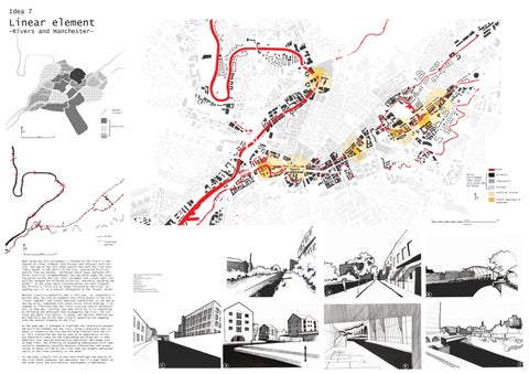
When targeting this assignment, I focused on the rivers in Manchester as linear elements that dissect and intersect with the city. The map on top left shows exactly how much the river acts like a border in the fabric of the city, separating districts sharply from one another. (Different hatch types represent different districts/ neighbourhoods) The map below shows the crossing points across the city ceter (bridges) that create small connections between the different districts, therefore ‘breaking the border’. In the areas where crossing points are more frequent, the district’s limits are no longer dictated by the river, expanding over it, as a natural consequence of the ‘broken’ border.
Maps created with data sourced from digimap Map Product: OS VectorMap® Local Raster Map Date: October 2020 Data Licence: OS Digimap Licence Map Projection: British National Grid (EPSG:27700) https://digimap.edina.ac.uk/roam/map/os
On the same map, I intended to highlight the interaction between the built environment and the river, using a grayscale that reduces in intensity the less the building interact with the river. This interaction may now be seen as an opportunity to create beautifull views out the highlighted buildings but it most definitely also implies dealing with additional challenges such as flood risks, the difficulty of expanding underground,(with tube stations, basements) possible mosquito infestations and accumulation of waste carried by the river that can produce unpleasant smells in the close proximity of the water. To conclude, I would like to once more highlight the duality of the river (both connector and separator) and it’s huge impact on the urban grain and architectural development in Manchester.
4
2
Whereas rivers are generally seen in this way - as ‘separators’ I believe they can also be elements that bring places in the city ‘closer together’ and create important connections. In the map on the top write, completed with seven serial vision drawings, I attempted to illustrate how the rivers crossing central Manchester are, in some way, ‘uniting’ the same districts it is separating. By following the walk-path that accompanies the river, one can cross the whole city centre, in maybe, not the most efficient way, but definitely one of the most visually appealing and engaging with the natural elements of the city.
6
1
1
3
5
7