Tewksbury Scenic Auto Tour


Tewksbury Scenic Auto Tour
Sponsored by the Tewksbury Historical Society
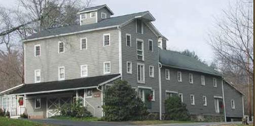
Starting point – Mountainville Meeting Hall, 60 Water Street, this is today’s Tewksbury Historical Society headquarters where you can browse our collection, purchase items, and visit the Fallen Veterans’ Memorial
The tour is designed to cover much of historic Tewksbury, including most of the Scenic Roads and places of interest. There are a few necessary short excursions outside of the township and some backtracking.
L = LEFT TURN R = RIGHT TURN C = CONTINUE STRAIGHT AHEAD
0.0 START - 60 Water Street, Mountainville Meeting Hall
HEAD EAST Towards Mountainville Village
0.1 Interesting historic house and decorated barn
C becomes Main Street after the bridge
Mountainville Meeting Hall


Mail Pouch Barn Next on your right, an old carriage works and blacksmith shop owned by James Apgar, and later an automotive repair shop and gas station.

Page 5
Former Carriage Works

Old Farley General Store, above, below as it is today

0.2 On your left, the old Farley General Store
On your left the house built by J. C. Farley in ~1870, later the Charles Philhower Homestead, and don’t miss the old barber shop, now a studio
Next on the left the Mountainville Hotel built in 1824 as an inn and tavern by Daniel Potter. After various owners, it returned to the Potter family in 1873, and Jonathan Potter, an entrepreneur, was an innkeeper,carpenter, distiller, blacksmith, horse trader, and a clothing merchant It was the center of town functions into the 1950’s, and the home of the fifth generation Meta Potter until the 1990’s
Old Barber Shop


Former Mountainville Hotel

On your left at Philhower Road, one of the Potter family houses
0.3 The ruin on your right is an old distillery
0.4 R SAW MILL ROAD (just over the bridge) Stone Cottage (circa 1840) on your left
0.6 KOVEN FARM former Lindabury Boarding House (from 1880s)


Old Distillery
1840 Stone Cottage
Koven Farm

1.4 Paleface Mountain Colony, on right at Water Wheel. A failed attempt to build Hell Mountain country resort in the 1940s, not a mill site
1.8 Mountain Road leading up to Hell Mountain
1.9 Old Hoffman Mill on right, then the millpond just above it
2.3 Pass over the Stone Bridge and the Vescelius tannery ruins are on the left with the millpond beyond This was a bark tanning operation which was an obsolete process by the 1890's when the organic chemical industry developed
2.5 L OLD TURNPIKE ROAD (517)

3.0 L FARMERSVILLE ROAD
Dairy farm to the right
The Old Sutton General Store is also at the intersection, having been moved twice at the crossroad
3.5 Pass through the old Smith's Family's Fieldcrest Farm

Smith Family's Fieldcrest Farm

Water Wheel at Paleface Mountain Colony
Vescelius Tannery Ruins
4.5 Look for the Old Farmersville Schoolhouse on the right (see bell tower). Moved here from near Fairmount Road
4.7 L Sutton Road
6.0 C Sutton Road straight ahead
6.3 Just past Guinea Hollow on the right is the 1726 Farmstead
6.6 Pass over newly restored Stone Arch Bridge
6.9 R Cokesbury-Califon Road
7.2 L Bear left at Philhower Road junction
7.7 C Cross over Rt. 512 to Main Street
8.0 Welcome to Califon Borough (formerly called California, seceded from Tewksbury in 1918. BEX's Cafe on the right
8.1 R Bank Street/Vernoy Road
9.2 Proceed to Historic Vernoy, along the South Branch of the Raritan, criss-cross the Columbia Trail, the abandoned Central RR of NJ High Bridge branch rail line, which served the dairy, farming, mining, and passenger trade This hiking/biking trail starts at Bartley in Morris County and terminates in High Bridge where it had connected to the CNJ Mainline until the early 1980s
9.4 Old Stone Building
9.9 R Valley Brook Road (truss bridge left)


Old Farmersville School
1726 Farmstead
Columbia Trail

Serenity Hills Farm


10.3 R Beavers Road (sharp turn)
10.9 Serenity Hills Farm on the right
11.3 C on Beavers Road
12.1 L Fairmount Road (512)
13.3 On the right the Christie Hoffman Farm, now township park
13.7 R Old Turnpike Road (517)
13.8 One of the many Historic Lime Kilns is seen on the right Lime for agriculture and mortar was made by heating ground up limestone using wood or charcoal as fuel.
14.7 L Hollow Brook Road
16.0 The author (Hardy Boys) Nancy Drew's Former Home on the right
17.0 R Homestead Road Seven Springs Farm (at the turn)
then
Serenity Hills house & barn
Seven Springs Farm
Lime Kilns, now and
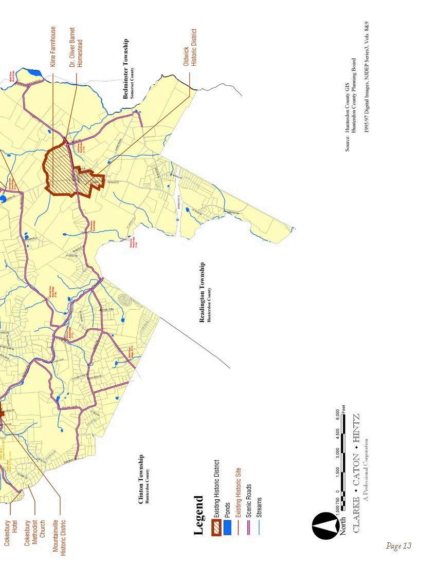
Homestead Road here is along the Society Line. this is the West New Jersey Society tract boundary established in 1691-92 that runs from Cushetunk to Pottersville
18.3 When you see the Palatine Road Stone Arch Bridge in front of you, turn left and continue on Homestead Road
18.8 Craigmar Farm on right
19.2 R Fox Hill Road Named for Johannes Peter Fuchs, an early German settler.
19.5 Stop after the first sharp right turn for a grand view, and you're back on the Society Line.
Craigmar Farm


Palatine Road Stone Arch Bridge
Grand View

20.3 Fox Hill Preserve- Lance Farm. Pass over new stone arch bridge
21.3 Just past Hollow Brook Road on the right you will come upon the Queen Anne Style Lincoln House, the low stone house next to it was a Speakeasy during prohibition.


21.7 R Old Turnpike (517)
22.4 R Fairmount Road/512
Former Speakeasy
The Methodist Church is on your right
23.0 Pascale Farm Park and Tewksbury Elementary School on your right
25.3 On the turn in Pottersville, the "In the Moon" Store, an 1830s era blacksmith shop. Dory Bush ran it until 1935, before converting it into an auto repair shop and filling station

Fairmount Methodist Church
Former Blacksmith Shop
Cross over the tail race of the Historic Wortman Mill Site, which is on your right
25.5 R McCann Mill Road, the Black River General Store is on the left at the turn.
Proceed past the Life Camp, a summer recreation facility for children
27.3 R Black River Road
27.7 View Rockabye RR bridge abutments on right
27.8 R Vliettown Road

27.9 The Vliet Family Farm on your left. The Rockabye RR crossed here
28.3 At the top of the hill on the right is the Seward Johnson Family's (J&J Company) Cedar Lane Farm
29.1 L Cold Brook Road
29.4 Cold Brook Farm on the right
30.2 L Lamington Road, immediate right on Felmley Road

Historic Wortman Mill Site
Vliet Family Farm
Cold Brook Farm
30.2 R Felmley Road
30.3 On your left is Pontefract Farm, the home of former Governor Christie Todd Whitman
31.1 Cross over the old Rockabye railroad roadbed
31.6 R Oldwick Road
31.7 L Rockaway Road
32.6 Colonel John Taylor's Grist Mill circa 1760 is on the left across from the Stavola Quarry, formerly the Houdaille and earlier the Preen Quarry. The tail race extends along the right side of the road.
33.8 New Truss Bridge replacing the historic one destroyed by an errant trucker
34.1 Kluge's Stone House and Thatched Cottage
Kluge's Stone House and Thatched Cottage

34.3 The Hill and Dale Farm, the previous property of Thomas J. Watson, of IBM fame.
35.9 Just before the Mountainville bridge, the old mill sites left and right.
36.1 L Main Street C Water Street (named change after bridge)
36.3 Mountainville meeting hall on the left
37.0 R Longview Road - historic farms on both corners
37.1 On the right a Log Cabin
38.1 L Philhower Road
38.4 L Sutton Road
38.7 L Cokesbury-Califon Road
40.6 L Cokesbury Road
40.8 At the next corner continue right at intersection with Water Street; on the left an historic Blacksmith Shop, Wheelwright Shop and Former Hotel. Just after the turn the Cokesbury Methodist Church on the left.
41.7 L Bissell Road
42.4 L Still Hollow Road
42.8 Old Distillery and Halsey Farm House
43.0 Obercian 1760/1820 House
43.2 Lindabury 1880 Farm


Hill and Dale Farm
Cokesbury Methodist Church
Lindabury 1880 Farm Page 17

43.7 R Rockaway Road (very sharp turn)
44.4 R Meadow Lane Pony Truss Bridge circa 1903
45.2 L Bissell Road
45.5 Don't miss the Old Bissell School House on your right
37.0 R RockawayRoad (re-route over to 517) Cross Society Line at Potterstown Road Your are at the Society Line, established in 1708, separating the southeast portion of the township chased from the Lenape Indians and the thwest portion purchased two years later by the st Jersey Society.

6 L North on Oldwick Road (523)
9 Melick's Town Farm - right, Oldwick Fire mpany left, Oldwick Village Historic District
6 On your left the Barnet Hall Academy, orginally t as a school, now the library and community ter, on your left the restored Zion Lutheron sonage (circa 1810)
6 R Joliet Street
ceed about .1 Miles; do not continue to the dead d. This is the former main road to Somerset unty. The white house across from the cemetery dden in the trees) is the site of the Rockaway ey Railroad Station. Built in the late 1800’s, the road connected Whitehouse to Oldwick, tersville, Gladstone, Ralston, Brookside, and the tnong section to Morristown
Old Bissell School House
Barnet Hall Academy
It was built on the cheap, and quickly became known as the “Rockabye Railroad ” due to its uneven roadbed It served the dairy,grain, feed, coal, and booming peach trade, as well as passengers,including travel to the Black River Glen, a popular park in Pottersville. The railroad was ripped up during WWI, and sold for scrap, the only profitable endeavour in its history
48.7 L William Street
48.9 L James Street
On the left is the historical society's restored carriage house Opposite the end of the street is the former Oldwick Methodist Church and the old cemetery is on your right.


Zion Lutheran Church whose congregation first gathered in 1714. Celebrating 300 years in 2014. The present building foundation and sanctuary walls date to 1749. The village was originally called Smithfield, but became Germantown, or New Germantown in 1753, with the influx of German Protestants, and the name was changed to Oldwick during WWI.
Page 19
Oldwick Methodist Church
Future headquarters of the historical society
Tewksbury Inn - dating 1743
General Store - (circa 1755) - lunch anyone?

49.1 The Van Doren Homestead (blue house) is on your left, followed by the Cold Brook Preserve, formerly part of the Van Doren Farm. The Magic Shop is on the right

49.3 Then farther on your left, Cold Spring Cottage, built in the 1700's, an early example of German-American architecture, and one of the oldest houses in Tewksbury.
49.8 R Homestead Road
Farley’s vault is at the corner, and is the burial place of Dr. Farley, a local physician in the mid-1800’s On your right (behind the fence) is the early Melick Homestead The barn across on the left (behind the stable) is a fine example of an old Dutch bank barn


50.4 Right, the Johnson family's Cedar Lane Farm

50.5 On your left the Miller Craig Farm, CRAIGMAR, dating back to the 1700s
50.6 On the right the 1786 Homestead Farm (formerly Rinehart)
50.9 The Clucas Corner (small plaque on tree) in memory of Fred Clucas, a well-known local farmer, whose family continues a long tradition of growing hay and grain crops
51.1 C Cold Spring Road (straight up the hill at Palatine intersection) John Mcguffin House (circa 1706) on your right
20
1786 Farm
John Mcguffin House
Vintage Photo of Van Doren House Magic Shop
Farley's Vault
51.8 Barlow Preserve on your left
52.2 Alder Creek Farm house right
52.5 R Fox Hill Road
52.5 L Wildwood Road (aka Pigturd Alley)

52.7 Old Stone Cottage left (circa 1820) Former Freeman Leigh (author of Fairmount Historic Notes) Cottage on right. The numerous stone fences were enclosures for pigs in the early farming days, hence the former name


53.0 C Sawmill Road You are now in the old commerical district of Lower Fairmount There were 5 saw mills, 1 grist mill, and the tannery run by the power of Sutton Brook The Vescelius Tannery is on the right
53.7 R Burrell Road On the right side just before the crest of the hill is a lime kiln, the last one operated in the township
54.3 On your left and right The Hart Farm, also a former vineyard, the Tewksbury Wine Cellars Winery
54.8 L Boulder Hill Road The adventuresome can turn right here and go a short distance to view the newest covered bridge in the state Don't forget to return
55.4 L Guinea Hollow Road Look to the right just before the next intersection, you will note the mill race that fed a saw mill
55.9 R Main Street (over the bridge) -- This concludes the Tour!
Page 21
Covered Bridge Barlow Preserve
Former vineyard, the Tewksbury Wine Cellars Winery