REVIEW OF WARD BOUNDARIES 2023
Ward Boundary Plan
ACKNOWLEDGMENT OF COUNTRY
Lake Macquarie City Council dhumaan Awabakala ngarrakal yalawaa, yalawan, yalawanan. Lake Macquarie City Council acknowledges the Awabakal people and Elders past, present and future.
Dhumaan ngayin ngarrakalu kirraanan barayidin. We remember and respect the Ancestors who cared for and nurtured this Country.
Ngarrakalumba yuludaka bibayilin barayida baaduka. It is in their footsteps that we travel these lands and waters.
Why are we reviewing our ward boundaries? 3 Our current wards and variance 5 Methodology for determining proposed ward boundaries 7 East Ward 9 North Ward 11 West Ward 13 Map of proposed alterations to ward boundaries 15 Map of proposed ward boundaries 16 Have your say 17 Appendix 1: Relevant sections of the NSW Local Government Act 1993 18
CONTENTS
Wording
by the Aboriginal Reference Group and translated by Miromaa Aboriginal Language and Technology Centre.
Plan 2023 2
Lake Macquarie City Council - Ward
Boundary
WHY ARE WE REVIEWING OUR WARD BOUNDARIES?
The NSW Local Government Act 1993 (the Act) requires councils to review ward boundaries to ensure that the difference in the number of electors across each ward does not exceed 10 per cent.
An August 2022 review of NSW Electoral Commission data identified a need for Lake Macquarie City Council to alter our ward boundaries to rectify a 11.28 per cent variance. The latest available data indicates this variance has grown to 13.49 per cent.


Under the Act, any alterations to ward boundaries must be finalised 10 months before the closing date for the next ordinary election (September 2024).
This document has been developed to help our community understand the proposed alterations to ward boundaries and how it may affect them.
The proposed alterations outlined in this plan will bring our three wards – East, North and West – back within 10 per cent or less variance.
We have considered future population growth – particularly in our North and West wards – when developing the proposed boundary alterations to help reduce the need for future alterations.
The proposed boundary alterations mainly impact suburbs in northern Lake Macquarie. Maps and information about the proposed changes to each ward boundary are included in this plan.
The Lake Macquarie community is invited to review this Ward Boundary Plan and make a submission via our online engagement platform, Shape Lake Mac, by email or by post. For more information on how you can have your say, see page 17 of this plan.
Submissions close on Wednesday 6 September 2023.
Submissions will be considered and a final Ward Boundary Plan will be presented to Council for adoption in late September 2023. The Ward Boundary Plan will then be forwarded to the NSW Electoral Commission for use at the next local government election in September 2024.
KEY DATES
24 July 2023: Council resolves to place the Ward Boundary Plan on public exhibition
26 July 2023: Public exhibition begins
6 September 2023: Public exhibition closes
25 September 2023: Report to Council with revised Ward Boundary Plan for adoption
Before 5 October 2023: Submit adopted Ward Boundary Plan to the NSW Electoral Commission
3
City Council - Ward Boundary Plan 2023 4
Lake Macquarie
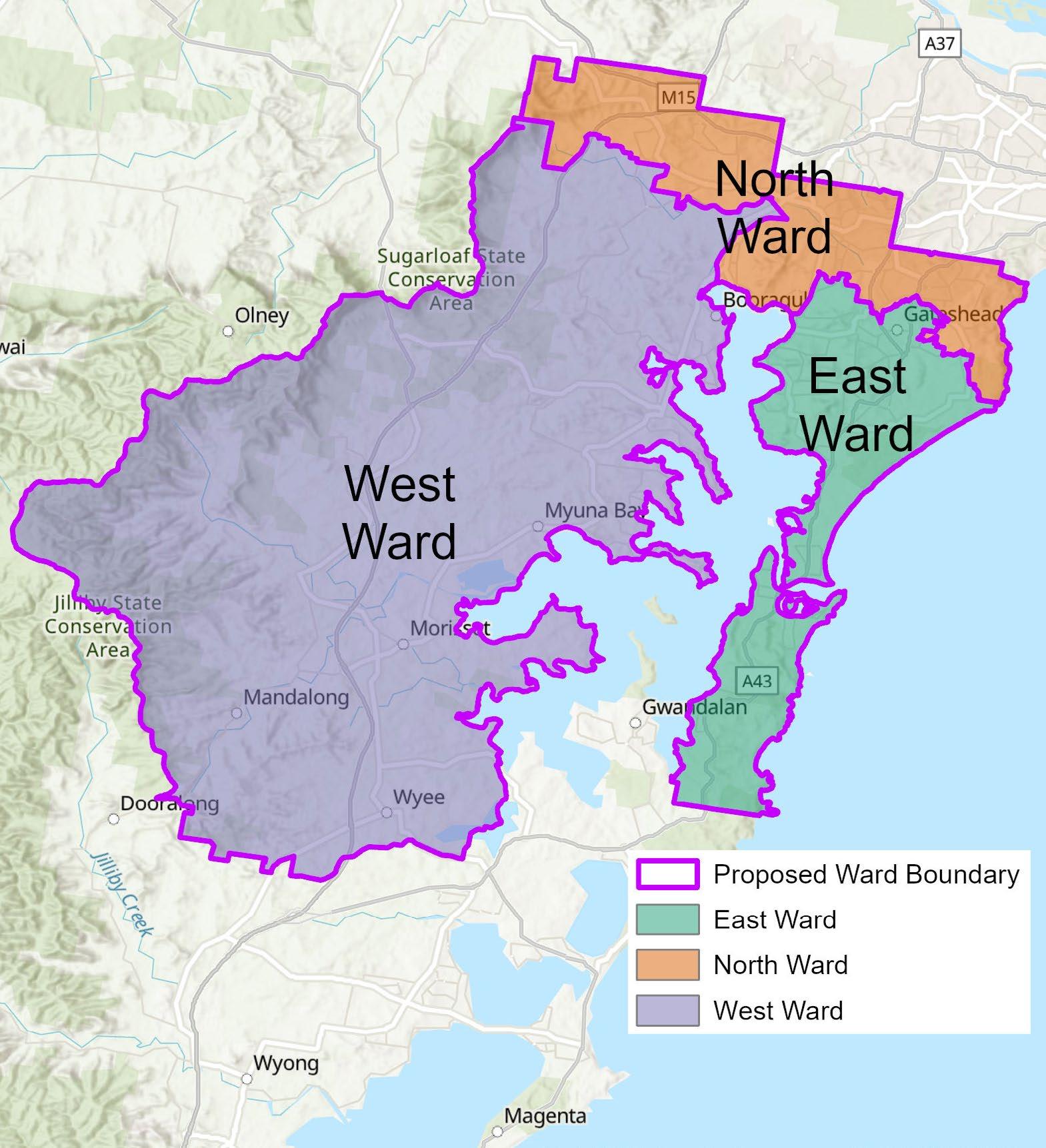
OUR CURRENT WARDS AND VARIANCE
Lake Macquarie City Council is divided into three wards: East, North and West. Each ward elects four Councillors, plus a popularly elected Mayor resulting in 13 Councillors.

The map below shows the current ward boundaries in Lake Macquarie.
The difference in the number of electors across our three wards was identified in May 2023 as 13.49 per cent.
The NSW Local Government Act 1993 requires the difference to be less than 10 per cent.
Making the boundary alterations proposed in this document will bring our wards within the required 10 per cent variance, and help reduce the need for future alterations over the coming decade.
Using elector data from May 2023, the table below illustrates how the proposed ward boundary alterations reduces the variance of the current wards.
Ward Electors in Electors in current wards proposed wards
Once adopted by Council, new ward boundaries will take effect for the next local government election in September 2024.
Did you know?
The current ward boundaries in Lake Macquarie City have not significantly changed since the NSW Local Government Act was established in 1993.
5
East 52,164 56,831 North 53,173 55,266 West 59,203 52,443 Total 164,540 164,540 Variance 13.49
8.37
per cent
per cent
Lake Macquarie City Council - Ward Boundary Plan 2023 6
METHODOLOGY FOR DETERMINING PROPOSED WARD BOUNDARIES
The following guidelines were used to develop our proposed ward boundaries:
FUTURE GROWTH
The number of electors in Lake Macquarie City is expected to increase by more than 25,000 by 2040, with significant growth forecast in West and North wards around Morisset and Cameron Park. The proposed ward boundaries account for this growth and will reduce the need for future boundary alterations.

SUBURB BOUNDARIES
Where possible, we have avoided splitting suburbs across wards to help make ward boundary information easier for our residents to understand and remember come election time.
The proposed boundary alterations will see some whole suburbs change wards to address elector variance, while in other cases only minor adjustments are proposed, affecting a small group of electors.
STATISTICAL AREA BOUNDARIES
Where possible, whole Statistical Area Level 1 Boundaries, as used by the Australian Bureau of Statistics, have been retained.
LAKE FRONTAGE
Lake Macquarie is the sparkling heart of our city, and reflects the lifestyle and values of our community. As such, the proposed boundary alterations retain lake frontage across all three wards.
7 Lake Macquarie City Council - Ward Boundary Plan 2023 8
EAST WARD
CURRENT WARD MAP
East Ward currently includes the suburbs of Belmont, Belmont North, Belmont South, Bennetts Green, Blacksmiths, Cams Wharf, Catherine Hill Bay, Caves Beach, Charlestown, Crangan Bay, Croudace Bay, Eleebana, Floraville, Gateshead, Jewells, Little Pelican, Marks Point, Moonee, Mount Hutton, Murrays Beach, Nords Wharf, Pelican, Pinny Beach, Redhead, Swansea, Swansea Heads, Tingira Heights, Valentine, Whitebridge and Windale.
PROPOSED CHANGE FROM EAST WARD
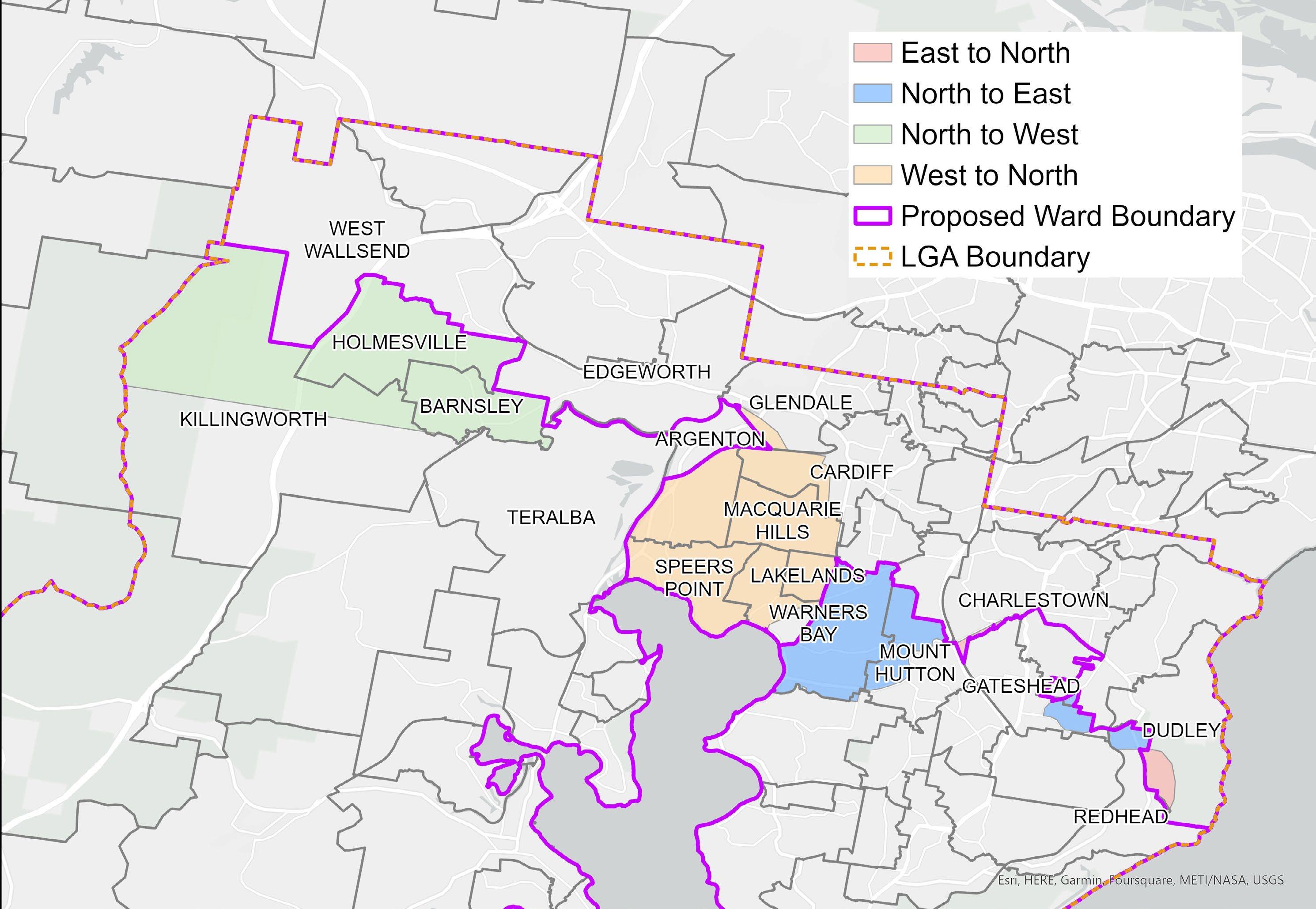
The proposed boundary alteration will see parts of Charlestown, Dudley and a small section of Whitebridge that are currently in East Ward move to North Ward.
PROPOSED CHANGE TO EAST WARD
Suburbs proposed to join East Ward include parts of Warners Bay, Mount Hutton, Gateshead, Redhead and Eleebana that are currently in North Ward.


PROPOSED EAST WARD MAP
9
NORTH WARD
CURRENT WARD MAP
North Ward currently includes the suburbs of Adamstown Heights, Barnsley, Cameron Park, Cardiff, Cardiff Heights, Cardiff South, Charlestown, Dudley, Edgeworth, Elermore Vale, Garden Suburb, Gateshead, Glendale, Highfields, Hillsborough, Holmesville, Kahibah, Killingworth, Kotara South, Mount Hutton, New Lambton Heights, Rankin Park, Redhead, Seahampton, Warners Bay, West Wallsend and Whitebridge.
PROPOSED CHANGE FROM NORTH WARD
The proposed boundary alteration will see the current North Ward suburbs of Holmesville, Barnsley and the northern part of Killingworth move into West Ward, while the parts of Warners Bay, Mount Hutton, Gateshead, Redhead and Eleebana that are currently in the North Ward will become part of East Ward.

PROPOSED CHANGE TO NORTH WARD
Suburbs proposed to join North Ward include current West Ward suburbs of Boolaroo, Speers Point, Macquarie Hills, Lakelands and parts of Cardiff, Warners Bay and Glendale, as well as parts of the current East Ward suburbs of Whitebridge, Dudley and Charlestown.
PROPOSED NORTH WARD MAP

11
Lake Macquarie City Council - Ward Boundary Plan 2023 12
WEST WARD
CURRENT WARD MAP
West Ward currently includes the suburbs of Arcadia Vale, Argenton, Awaba, Balcolyn, Balmoral, Blackalls Park, Bolton Point, Bonnells Bay, Boolaroo, Booragul, Brightwaters, Buttaba, Cardiff, Carey Bay, Coal Point, Cooranbong, Dora Creek, Eraring, Fassifern, Fennell Bay, Fishing Point, Freemans Waterhole, Glendale, Kilaben Bay, Killingworth, Lakelands, Macquarie Hills, Mandalong, Marmong Point, Martinsville, Marrabooka, Morisset, Morisset Park, Myuna Bay, Rathmines, Ryhope, Silverwater, Speers Point, Sunshine, Teralba, Toronto, Wakefield, Wangi Wangi, Warners Bay, Windermere Park, Woodrising, Wyee, Wyee Point and Yarrawonga Park.
PROPOSED CHANGE FROM WEST WARD
The proposed boundary alteration will see the current West Ward suburbs of Boolaroo, Speers Point, Macquarie Hills, Lakelands and parts of Cardiff, Warners Bay and Glendale move to North Ward, while other parts of Warners Bay that are currently in West Ward will become part of North Ward.


PROPOSED CHANGE TO WEST WARD
Suburbs proposed to join West Ward include the current North Ward suburbs of Holmesville, Barnsley and the northern part of Killingworth.
PROPOSED WEST WARD MAP
13
Lake Macquarie City Council - Ward Boundary Plan 2023 14
MAP OF PROPOSED ALTERATIONS TO WARD BOUNDARIES
MAP OF PROPOSED WARD BOUNDARIES
15
Lake Macquarie City Council - Ward Boundary Plan 2023 16
HAVE YOUR SAY
Submissions close Wednesday 6 September 2023.
If you have questions about the proposed boundary alterations, please contact our Customer Service Centre on 4921 0333 or email council@lakemac.nsw.gov.au.

APPENDIX 1
Appendix 1: Relevant sections of the NSW Local Government Act 1993
210 Division of areas into wards
1. The council may divide its area into divisions, called “wards”.
2. The council may abolish all wards.
3. The council may alter ward boundaries.
4. The council may name or rename a ward.
5. A council must not divide an area into wards or abolish all wards unless it has obtained approval to do so at a constitutional referendum.
6. A by-election held after an alteration of ward boundaries and before the next ordinary election is to be held as if the boundaries had not been altered.
b. prepare and publicly exhibit a plan detailing the proposed division or alteration (the “ward boundary plan”).
2. The council must give public notice of the following:
a. the place at which the ward boundary plan may be inspected,
b. the period for which the plan will be exhibited (being a period of not less than 28 days),
c. the period during which submissions regarding the ward boundary plan may be made to the council (being a period of not less than 42 days after the date on which the ward boundary plan is placed on public exhibition).
Lake Macquarie City Council welcomes feedback from the community on proposed alterations to our ward boundaries.

You can make a submission at shape.lakemac.com.au/wardboundaries
Alternatively, to make a submission you can: Email: council@lakemac.nsw.gov.au
Subject: Review of ward boundaries
Mail your written submission to:
Lake Macquarie City Council
Box 1906, Hunter Regional Mail Centre, NSW, 2310
KEY DATES
24 July 2023: Council resolves to place the Ward Boundary Plan on public exhibition
26 July 2023: Public exhibition begins
6 September 2023: Public exhibition closes
25 September 2023: Report to Council with revised Ward Boundary Plan for adoption
Before 5 October 2023: Submit adopted Ward Boundary Plan to the NSW Electoral Commission
7. The division of a council’s area into wards, or a change to the boundaries of a ward, must not result in a variation of more than 10 per cent between the number of electors in each ward in the area.
210A Consultation, public notice and exhibition of proposals regarding ward boundaries
1. Before dividing a council’s area into wards or altering a council’s ward boundaries, the council must:
a. consult the Electoral Commissioner and the Australian Bureau of Statistics to ensure that, as far as practicable, the proposed boundaries of its wards correspond to the boundaries of appropriate districts (within the meaning of the Electoral Act 2017) and census districts, and to ensure that the proposed boundaries comply with section 210 (7)
3. The council must, in accordance with its notice, publicly exhibit the ward boundary plan together with any other matter that it considers appropriate or necessary to better enable the plan and its implications to be understood.
4. Any person may make a submission to the council regarding the ward boundary plan within the period referred to in subsection (2) (c).
5. The council must consider submissions made in accordance with this section.
211 Ward boundaries
1. The council of an area divided into wards must keep the ward boundaries under review.
2. If:
a. during a council’s term of office, the council becomes aware that the number of electors in one ward in its area differs by more than 10 per cent from the number of electors in any other ward in its area, and
b. that difference remains at the end of the first year of the following term of office of the council, the council must, as soon as practicable, alter the ward boundaries in a manner that will result in each ward containing a number of electors that does not differ by more than 10 per cent from the number of electors in each other ward in the area.
3. Nothing in subsection (2) prevents a council that has become aware of the discrepancy referred to in subsection (2) (a) from altering its ward boundaries before the end of the first year of the following term of office of the council.
17 Lake Macquarie City Council - Ward Boundary Plan 2023 18
shape.lakemac.com.au/wardboundaries
