7 minute read
6. MOVEMENT INFRASTRUCTURE


6. MOVEMENT INFRASTRUCTURE
Infrastructure and land use planning that supports walking, assisted mobility, cycling and public transport will be critical to ensuring Morisset is an attractive place to live and work.
Advertisement
This section outlines the strategic planning framework that supports the Morisset Place Strategy, including the local, regional and state plans that apply to the area.
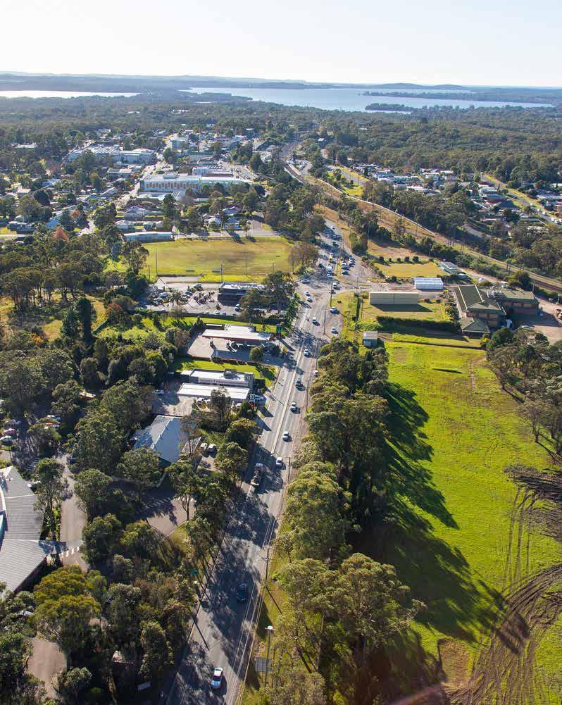
Morisset is uniquely located next to the bidirectional M1 Motorway interchange. Route B53 (also known as Main Road 217 or MR217) connects south-western Lake Macquarie to the M1 via Mandalong Road and Dora Street at Morisset. Parts of the road network currently experience high traffic volumes during peak periods.
Morisset railway station is located on the Main North line, and is serviced by InterCity trains (Central Coast and Newcastle Line services) travelling from Sydney Central and Gosford to Newcastle. In addition to school buses, the bus lines through Morisset offer bus connections of varying frequency to Cooranbong, Sunshine, Silverwater, Toronto, Cessnock and Lake Haven via Wyee.
most attractive and often the only realistic choice. However, the combination of low density, separated land uses and car-prioritising infrastructure decisions has consequences in terms of household costs, equity and choice. If we reduce car dependency, and vehicle ownership, we can reduce public health and infrastructure costs; reduce greenhouse gas emissions and air pollutants; improve the environment; and increase personal health and social equity.
This requires better walking, cycling and public transport networks, ideally that also integrate nature into neighbourhoods to get more people outdoors while creating wildlife corridors and stormwater solutions. These networks can lead to better placebased connections, where more people participate in and feel part of community life.
Council has adopted the Walking, Cycling and Better Streets Strategy and Urban Greening Strategy, identifying requirements for new pedestrian and cycling infrastructure, street trees, urban vegetation and supporting green infrastructure. identifying requirements for new pedestrian and cycling infrastructure, street trees, urban vegetation and supporting green infrastructure.
We can realise these outcomes by designing new communities, and retrofitting existing low density residential areas, into 15-minute neighbourhoods.
The 15-minute neighbourhood changes how we plan and design growth. It supports people who want to live and work locally and who seek to get around without a personal vehicle. It’s already a concept that we can see in the region, in more traditional towns and suburbs developed before the 1960s, including Maitland, Raymond Terrace and Cessnock.
Rather than cities, towns, villages and communities being separate zones for living, working, education, recreation and entertainment, they can be mixed neighbourhoods where people can generally access most everyday needs within a 15-minute walk or cycle from where they live.
Instead of residential growth radiating from a strategic centre, the 15-minute neighbourhood reestablishes the role and convenience of local centres, public areas and attractive, healthy streets, alongside the still-important centres that provide major concentrations of goods, services and employment.
Future growth will be intensified within a 15-minute walk of Morisset centre and other local centres, the Morisset railway station/transport interchange, schools, parks and community facilities. Within these areas, a high-quality pedestrian and cycling network should be prioritised.
Existing cycle routes
Off-road (shared path or other)
On-road low difficulty
On-road medium difficulty
On-road hard difficulty
Possible new cycle routes and upgrades*
New off-road path (shared path or other)
On-road low difficulty (upgrade)
On-road medium difficulty (upgrade)
On-road high difficulty (upgrade)
Possible new link or off-road trail
Possibilities for upgrades on existing roads are varied and due to site-specific considerations and may include widening of road shoulders, kerb adjustments, upgrade of crossings, and traffic/speed management.
Morisset Transport Scoping Study
Council commissioned a high-level transport scoping study to investigate the impact of different growth scenarios on the Morisset road network. The study followed an approach provided by the NSW Movement and Place Framework. Streets were sorted into four categories based on the vision for Morisset, and place intensity and movement function of the roads and streets. This provided a basis to consider transport network challenges and opportunities to achieve the intent of each street.
Key conflict areas have both high movement and high place value, such as the area around Dora Street. As prescribed by the movement and place logic outlined in the framework, on streets with a high place function such as main streets and civic spaces, place quality needs to be supported to enhance pedestrian safety, local amenity and improve local business activity. This may be done through design, speed limits and/or diverting through traffic.
Preliminary options to reduce traffic congestion through the centre and improve the place function of Morisset town centre have been suggested for investigation. These include consideration of an alternative route to the north of the city centre, possibly using Awaba Street, or an alternative route on the southern side of the railway using Macquarie Street. A range of other opportunities to enhance both place function and traffic movement were also explored in the study and suggested for further investigation. These are varied and include potential new road links, upgrade of roads and intersections, revision of speed limits, pedestrian crossings, and changes to streetscaping to enhance place and/or manage movement. The study also noted that the streetscaping opportunities identified in Councils DCP for Morisset town centre are effective for promoting the Place value of the centre and should be investigated further as to how to best incorporate them with other identified opportunities.
We will investigate these suggestions further in the next phase of the Place Strategy which will include an Infrastructure Delivery Plan. In the meantime, we would be keen to hear views on potential improvements to transport in and around the centre.
6. MOVEMENT INFRASTRUCTURE
Main roads
These roads and routes are central to the efficient movement of people and goods. They include motorways, primary freight corridors, major public transport routes, the principal bicycle network and key urban pedestrian corridors. Their place activity levels are less intense. However, these roads and routes can have significant meaning to local people.
To support these roads and routes we need to prioritise their strategic movement functions. We can limit negative impacts to place qualities or community severance through their planning, design and operation.
Local streets
These are the majority of the streets in our communities. They often have important local place qualities. Activity levels are less intense than for civic spaces, but these streets can have significant meaning to local people. Town and village main streets are usually ‘local streets’.
To support these streets we need to provide access for walking, cycling and private vehicles; safe, low-speed environments; easy access to public transport; and access for local deliveries while limiting through-traffic.
Main streets
These streets are some of the most vibrant places in our cities and towns. They have both significant movement functions and place qualities. Balancing the functions of these streets is a common challenge.
To support main streets we need to improve place qualities while providing access for walking and cycling and safe, low-speed environments, while also allowing for the efficient movement of people and freight. Trade‐offs and compromises may be required.
Civic spaces
These streets are at the heart of our communities and have a significant meaning, activity function or built environment. They are often in our major centres, tourist and leisure destinations and community hubs. They are places for people, with a priority on place.
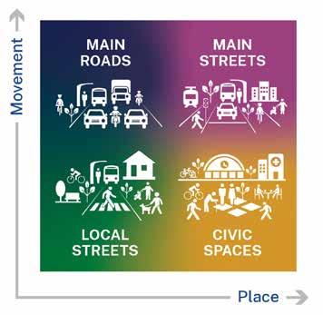
We support the place quality of these street environments by giving priority to pedestrians; providing safe, low-speed environments; managing freight and deliveries; providing easy access to cycle routes and public transport; and limiting through-traffic.
Street categories in Morisset town centre, with dashed lines show alternative bypass opportunities to reduce traffic through the centre and achieve the vision for a vibrant and attractive centre
Alternatives To Reduce Congestion In The Town Centre
To address the conflict between movement and place objectives along Dora Street between the town centre and the rail station, two route opportunities have been identified to reduce through traffic:
• via Macquarie Street, connecting to Dora Street at Stockton Street and Wharf Street
• via Awaba Street, including Awaba Street capacity upgrade with increases in speed to 70km/h
Both these options were considered in the preparation of the 2008 Structure Plan, but the link along the southern side of Morisset train line that connects Dora Street to Macquarie Street was preferred. Transport for NSW has undertaken preliminary investigations of this option and identified several geometrical constraints to its implementation.
The traffic scoping study therefore recommended that the alternative route in the northern part of Morisset via Awaba Street to be further considered.
These options are shown as dashed lines in the figure on page 67 and will be investigated further in the next phase of the Place Strategy.Street/Dora Street could be restricted to a left-out turn. This requires further investigation and alignment with proposed adjustments to Dora Street by Transport for NSW.
Mandalong Road upgrade
Today, a lot of traffic movement occurs between Morisset Peninsula and the M1 Motorway via Fishery Point Road, Dora Street and Mandalong Road. Mandalong Road is a state road and in 2022, the Federal Government and NSW Government announced funding towards an upgrade of Mandalong Road between Gateway Boulevarde and Wyee Road.
Transport for NSW is responsible for delivering the works which involve widening Mandalong Road between Gateway Boulevarde and Wyee Road to provide two travel lanes in each direction along with a new signalised intersection at the Wyee Road/Freemans Drive intersection and a new signalised intersection at the Gateway Boulevarde/ Mandalong Road Intersection.
Have your say
What do you think of the alternatives to reduce traffic through the centre?
Do you see opportunities or challenges in the greater Morisset transport system that should be further investigated in the next phase of the Place Strategy?
What can be done to make it easier for you to walk, cycle and take public transport in your everyday life?
Other Major Upgrades
In addition to the alternative routes for through traffic mentioned above, the study explores a range of other upgrades in Morisset and surrounds which will be further investigated in the next phase of the Place Strategy. For a full overview, see the report. Selected recommended upgrades in Morisset include:
• Mandalong Road/Dora Street upgrade (B53)dual lanes between M1 and Stockton Street, including a shared pathway and intersection upgrades: Mandalong Road/Dora Street / Freemans Drive and Mandalong Road/Gateway Boulevard intersections
• closing part of Kahibah Street and upgrading Doyalson Street and Newcastle Street to support new town park
• pedestrian and cycle upgrades at Dora Street
• streetscape improvements and speed reductions in town centre
• Fishery Point Road/B53 – upgrade to signalised intersection with Main Road (B53) with dual lanes on approach.


