NATIONAL CITY DOWNTOWN SPECIFIC PLAN
4
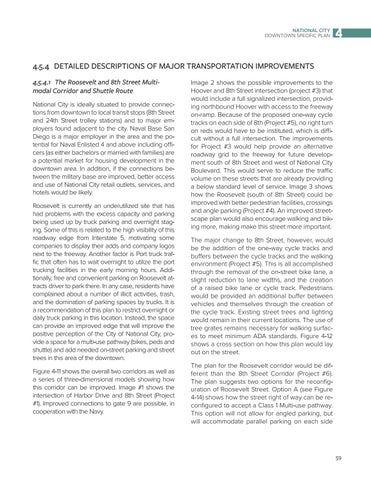
4.5.4  DETAILED DESCRIPTIONS OF MAJOR TRANSPORTATION IMPROVEMENTS 4.5.4.1  The Roosevelt and 8th Street Multimodal Corridor and Shuttle Route National City is ideally situated to provide connections from downtown to local transit stops (8th Street and 24th Street trolley stations) and to major employers found adjacent to the city. Naval Base San Diego is a major employer in the area and the potential for Naval Enlisted 4 and above including officers (as either bachelors or married with families) are a potential market for housing development in the downtown area. In addition, if the connections between the military base are improved, better access and use of National City retail outlets, services, and hotels would be likely. Roosevelt is currently an underutilized site that has had problems with the excess capacity and parking being used up by truck parking and overnight staging. Some of this is related to the high visibility of this roadway edge from Interstate 5, motivating some companies to display their adds and company logos next to the freeway. Another factor is Port truck traffic that often has to wait overnight to utilize the port trucking facilities in the early morning hours. Additionally, free and convenient parking on Roosevelt attracts driver to park there. In any case, residents have complained about a number of illicit activities, trash, and the domination of parking spaces by trucks. It is a recommendation of this plan to restrict overnight or daily truck parking in this location. Instead, the space can provide an improved edge that will improve the positive perception of the City of National City, provide a space for a multi-use pathway (bikes, peds and shuttle) and add needed on-street parking and street trees in this area of the downtown. Figure 4-11 shows the overall two corridors as well as a series of three-dimensional models showing how this corridor can be improved. Image #1 shows the intersection of Harbor Drive and 8th Street (Project #1). Improved connections to gate 9 are possible, in cooperation with the Navy.
Image 2 shows the possible improvements to the Hoover and 8th Street intersection (project #3) that would include a full signalized intersection, providing northbound Hoover with access to the freeway on-ramp. Because of the proposed one-way cycle tracks on each side of 8th (Project #5), no right turn on reds would have to be instituted, which is difficult without a full intersection. The improvements for Project #3 would help provide an alternative roadway grid to the freeway for future development south of 8th Street and west of National City Boulevard. This would serve to reduce the traffic volume on these streets that are already providing a below standard level of service. Image 3 shows how the Roosevelt (south of 8th Street) could be improved with better pedestrian facilities, crossings and angle parking (Project #4). An improved streetscape plan would also encourage walking and biking more, making make this street more important. The major change to 8th Street, however, would be the addition of the one-way cycle tracks and buffers between the cycle tracks and the walking environment (Project #5). This is all accomplished through the removal of the on-street bike lane, a slight reduction to lane widths, and the creation of a raised bike lane or cycle track. Pedestrians would be provided an additional buffer between vehicles and themselves through the creation of the cycle track. Existing street trees and lighting would remain in their current locations. The use of tree grates remains necessary for walking surfaces to meet minimum ADA standards. Figure 4-12 shows a cross section on how this plan would lay out on the street. The plan for the Roosevelt corridor would be different than the 8th Street Corridor (Project #6). The plan suggests two options for the reconfiguration of Roosevelt Street. Option A (see Figure 4-14) shows how the street right of way can be reconfigured to accept a Class 1 Multi-use pathway. This option will not allow for angled parking, but will accommodate parallel parking on each side
59