Hi
I am an architect and urban designer whose work navigates ways in which just urban transitions can be designed for and with our cities. My professional work revolves around architectural and infrastructure systems that are rooted in place while my research examines intersections of labor, platform urbanism and urban ecologies.
2
koushik srinath website koushik.srinath04@gmail.com ksrinath@andrew.cmu.edu (+1)- 4127854961
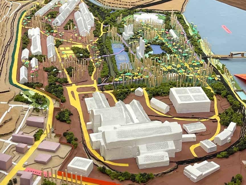
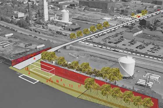
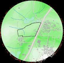
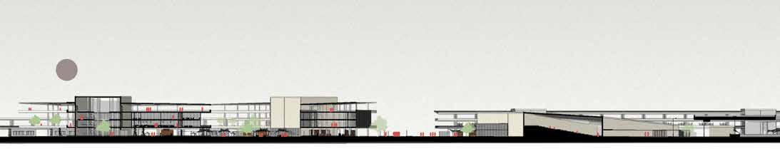
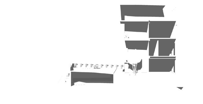
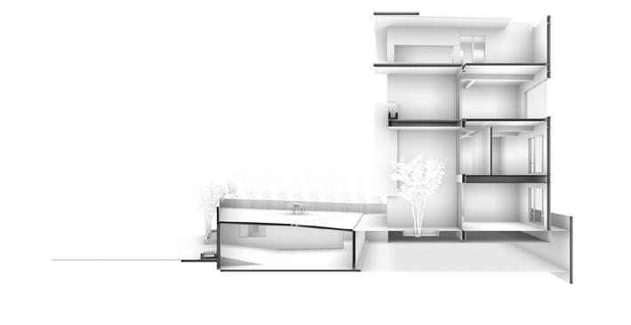
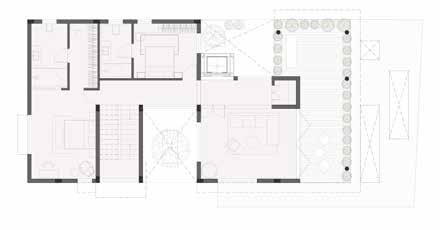
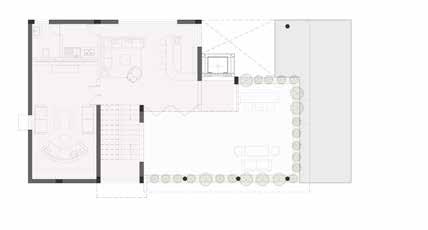
Braddock Futures
Rethinking the Edgar Thomson Mill
Location : Braddock, Pennsylvania
Type : Community Planning, Urban Design
Master of Urban Design; Studio Semester 2, MUD; Carnegie Mellon School of Architecture, Role - [Group Project] Research, Design, Model Making
Timeline- Jan 2023-May 2023
Area- multiple sites
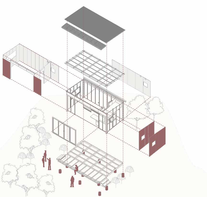
The proposal explores the transition of the ET site, beyond steel-making and towards a decarbonized future, starting with and keeping at its core, the needs and desires of the community — including for environmental and human health; reparative, environmental justice; community based social development; and historical and cultural specificity. The studio aims to develop design and research products towards ongoing community efforts of environmental repair and health. Students learn to bring together existing knowledge and to foreground community voices and histories in urban analysis and design. This includes conducting studies of the built environment and landscape and engaging with conversation and listening to critical voices to develop a contextual understanding of the ongoing history of the area, particularly on issues of ecology, toxicity, urban change, structural abandonment, and environmental justice.
Access the STORY MAP
3
4
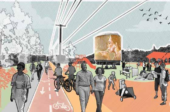
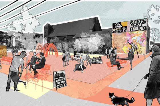
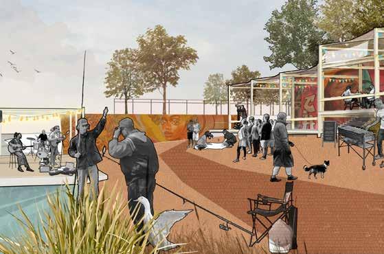
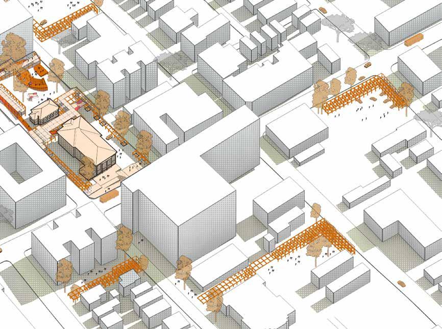
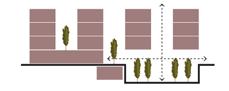
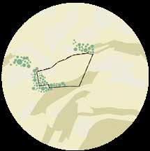
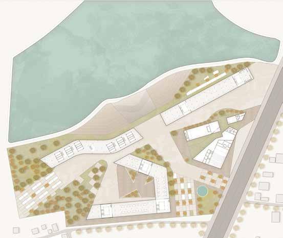
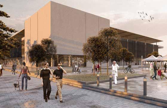
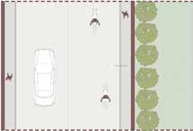
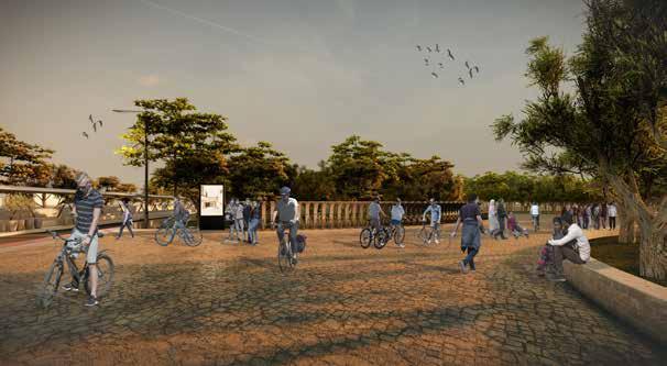
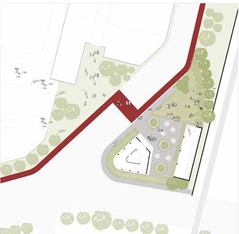
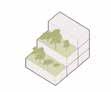
Reimagined trail at the Mononghahela riverfront
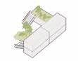
Repurposing Vacant, public lots along the peripheries of the mill
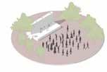
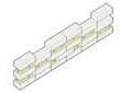
Reclaiming Braddock beach as a public space for performance and art
Working along the edges of the mill to redefine boundaries
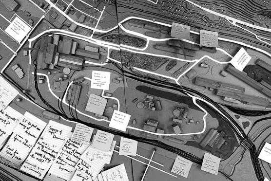
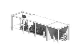
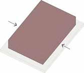
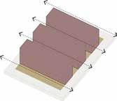
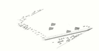
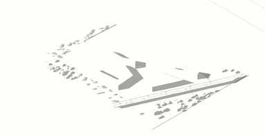
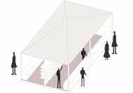
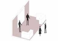
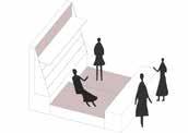
Hybrid Drawing as a Method
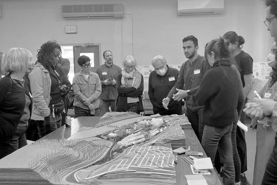
5
as
base
Model
a
for conversation and discussion.
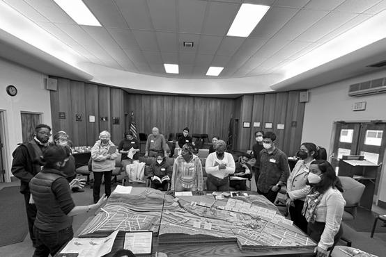
Third Community meeting with community leaders and updates made as per feedback.
Community Engagement
Notes and feedback during the community meeting
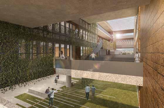
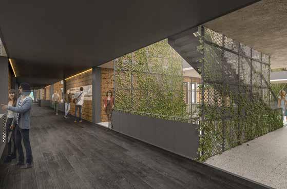
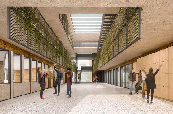
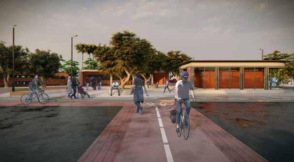
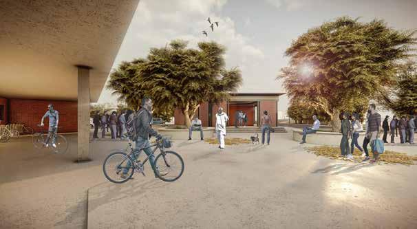
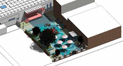
Community Service Hub at Herron Hill
community hub for North Oakland
Location : Pittsburgh, Pennsylvania
Type : Urban Design, Ecological Planning
Master of Urban Design; Studio Collaborator - Yash Parikh
Semester 1, MUD; Carnegie Mellon School of Architecture, Role - Complete Project Timeline- August 2022- December 2022
Area- multiple sites
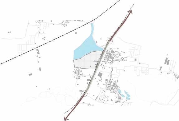
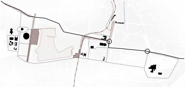
The Herron Hill CSH Proposal is an attempt in recognising the water infrastructure and providing and identity for North Oakland, a historical neighborhood in Pittsburgh. The location of the site is at the intersection of Center Avenue and Dithridge Street in the upper part of North Oakland. Center Avenue is a prominent East-West Connection corridor in Pittsburgh and due to this, the site and building have a high visibility. The buildings on site include the main pumping station which is still functional and the defunct laboratory at the rear. North Oakland and Upper Hill towards the North West have been segregated by geography and class throughout the last century and the impact of the separation exists today. Although separated through geography and administrative boundaries, this historical infrastructure network has connected neighbourhoods. The structure was determined viable for historical status as of 2020. Through various modes of mapping and analysis, interviews and other resources, the aim of the project was to propose a solution rooted in the dreams and aspirations of the community.
6
Strategy and Analysis
The strategy for the CSH of North Oakland is to create a well-connected node in the neighbourhood which also can be accessed by the surrounding areas. The diagram shows our primary intervention areas which are defined by the access corridors. We envision this intervention being a catalyst of change and allowing for varied modes of interaction, access and activity.
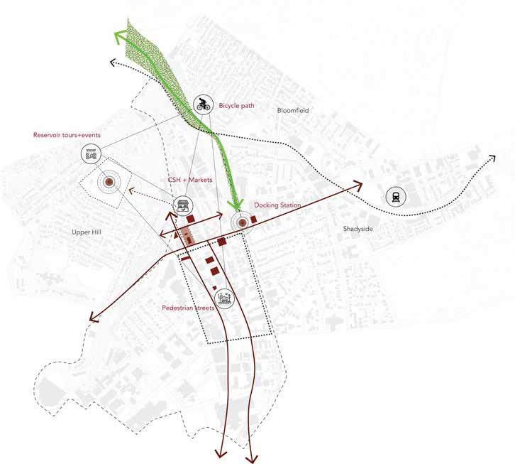
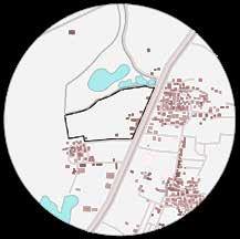
The population of North Oakland and the surrounding neighborhoods justify the location and provision of a community hub.
Most of the buildings in North Oakland are above 60ft in height and do not have access to public, open or green space.
North Oakland is fragmented by the presence of large open parking lots. These lots are mostly paid public lots which could be used for multiple functions.
7
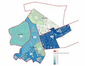
Population Analysis Building Heights Parking Lots
Site program and Adjacencies
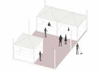
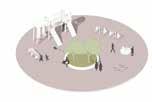
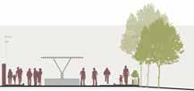
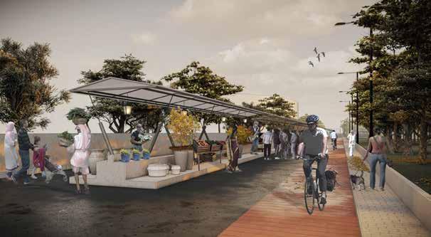
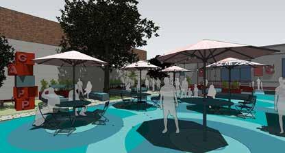
The Herron Hill site acts as a nucleus for the neighborhood and acts as a template for change. The site would have a multitude of functions including the performance space, the museum of water infrastructure within the lab building and meeting spaces for the community. The parking lots around the neighborhood would be provided with the scaffolding module which would provide frameworks for pop up markets, local groceries and other bottom up modes of culture production.
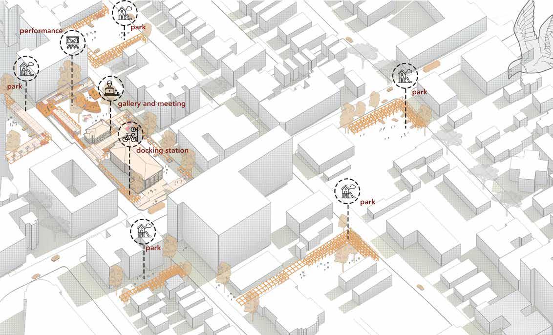
8
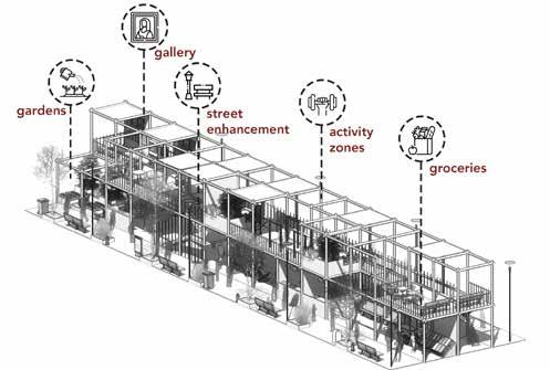
Modular Frameworks
The temporal nature of the scaffolding means that it would be lightweight, easy to transport and could be used for multiple functions. We understand the seasonal nature of such spaces, but over time we envision few of these pods and modules to be more permanent in nature based on feedback from the community.
Cafes and Pop up Stores
Local businesses would be provided with opportunities with the scaffolding network.
Outdoor Fitness Zones
Fitness zones for the community to promote a healthy lifestyle and access to the same.
Art Galleries
Open galleries for local artists to promote art and installations.
Allotment Gardens
Local businesses would be provided with opportunities with the scaffolding network.
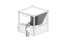
Docking Stations
Bicycle and scooter docking station to promote a green micro transit network.
Grocery stores and Farmers’ markets
Farm to table and local grocery stores for the community to promote bottom up distribution of food.
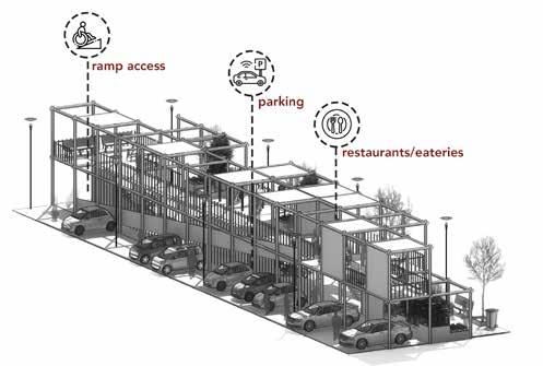
Repurposing Parking Lots
Huge Parking lots are repurposed as playful, active zones of community interaction while allowing the preliminary function of parking to remain.
9
10
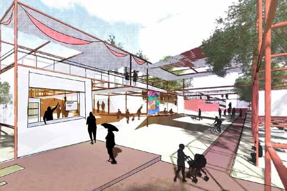
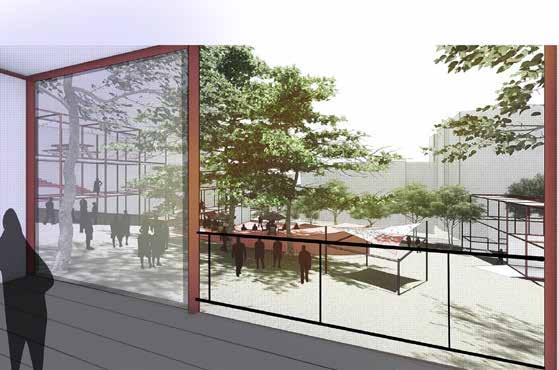
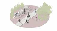
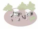
Entry to community space with modules within scaffolding
Pods within scaffolding that can be used for stalls, markets and small businesses.
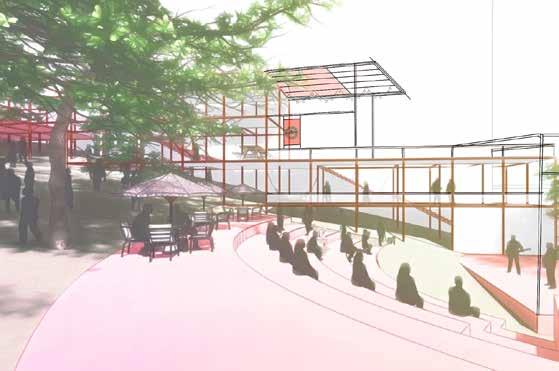
Amphitheater space with outdoor seating and display areas
Quick Sketch
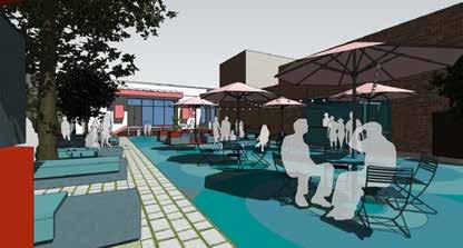
for Community Meeting
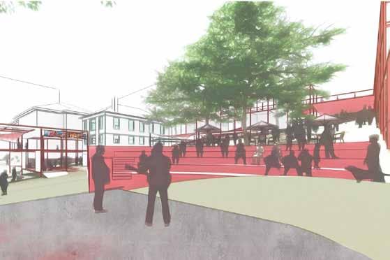
Performance space with Herron Hill Pumping Station in
the background
Renders
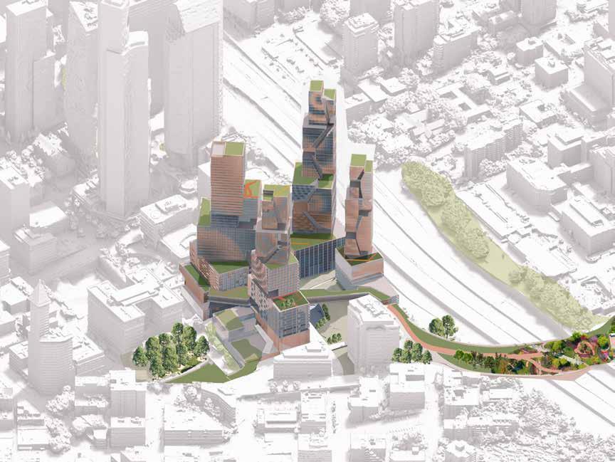
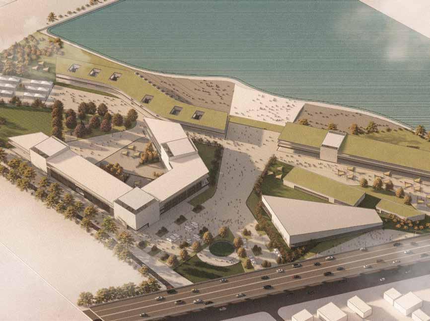
Seamless Seattle
reimagining Seattle’s Downtown
Location : Seattle, Washington
Type : Mixed use development, Adaptive Reuse, Transit design
Master of Urban Design; Competition
Collaborators : Autumn Chelsea, Shreya
Mathur, Yash Parikh, Srujan Gajjala
Semester 3, MUD; Carnegie Mellon School of Architecture, Role - Design and Presentation
Timeline- January 2024
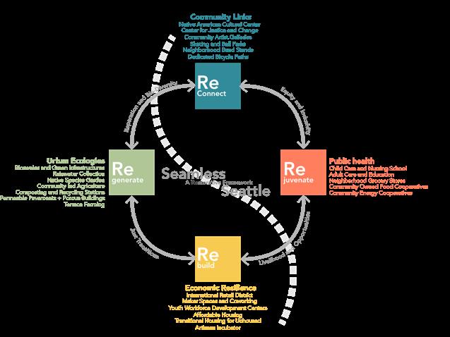
Seamless Seattle distinguishes itself by retaining vital civic functions on-site. The adaptive reuse of the jail into a museum and center for justice and change serves as an educational hub, shedding light on the justice system and inspiring societal progress. Area- 15.4 acres
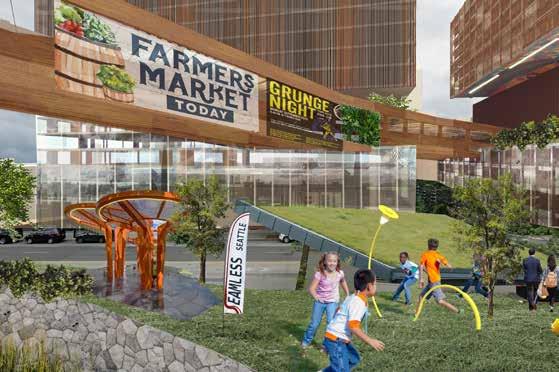
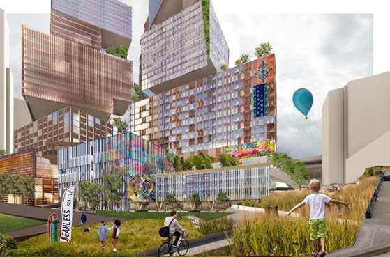
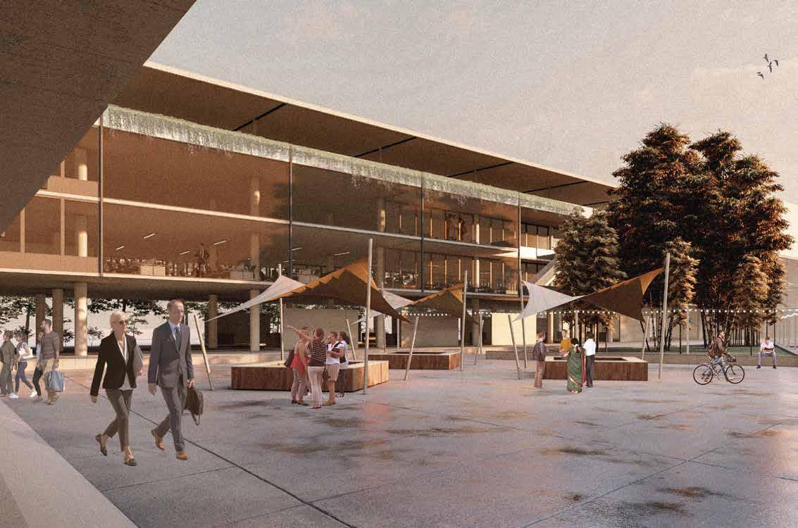
“Seamless Seattle” emerges as a transformative initiative, aiming to weave together, revitalize natural ecosystems, and breathe new life into the city’s core. Nestled amidst the innovation of diverse communities and rich ecologies, the project envisions bold and equitable change for downtown Seattle. At its core lies a vision of a cohesive, inclusive, and environmentally conscious city, breaking free from unjust historical frameworks. The project revolves around four key tenetsReconnection, Regeneration, Rejuvenation, and Rebuilding.

11
03
Strategy and Vision
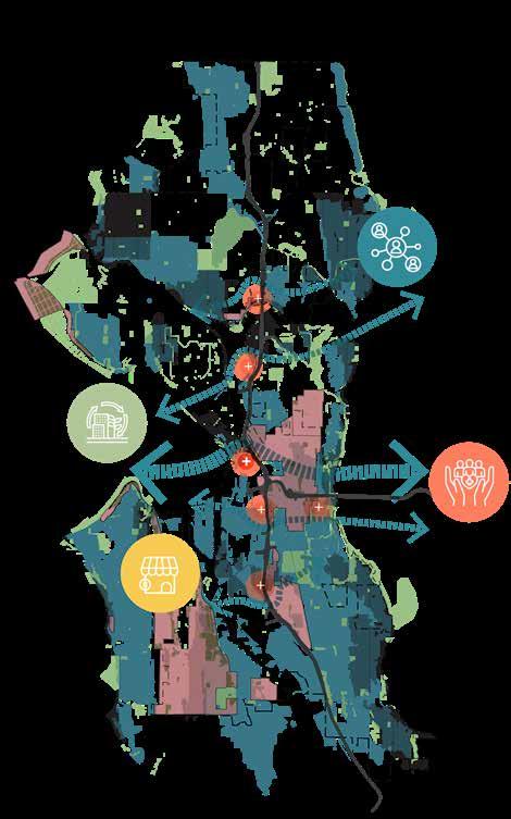
At a regional level, the project aims to stitch the seam created by the highway infrastructure which runs through Seattle. This would help redistribute and connect ecological systems on either side while also acting as public interfaces for the communities on either side.
Historically Redlined Neighborhoods
Drainage Basins
Intervention Zones
Parks and Green Zones
Highway Infrastructure
Environmental Justice Areas
Combined Sewer Overflows
12
LEGEND
13
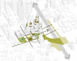
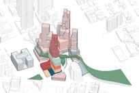
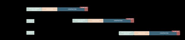
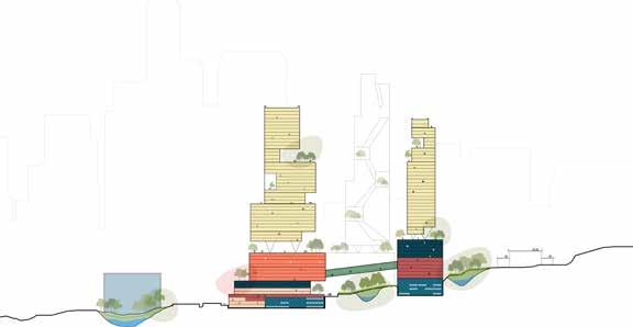
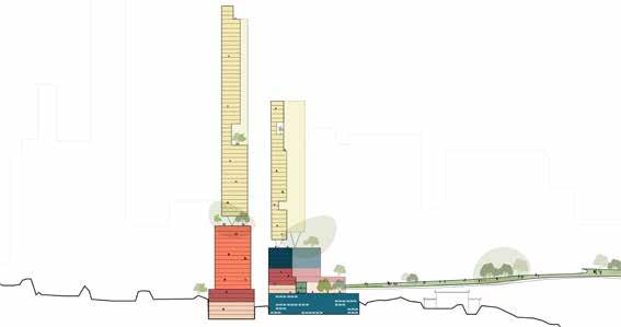
Program Distribution and Phasing
The project is divided into three phases, each functioning on its own. The first phase simultaenously addresses the adaptive reuse of the King County Courthouse and the historical Yesler building along with the construction of the largest tower block on site. The second and third phase are spread out over the construction of the three towers and the infrastructure of the Yesler linkway which is a highway lid connecting across to the neighborhoods on the other side. The entire project is spread out over
14
Residential Section A-A’ Section B-B’ Commercial Community Retail
Parking Retail Phase 1 Phase 2 Phase 3 A’ A B B’
and Care Hostel and Service Apartments

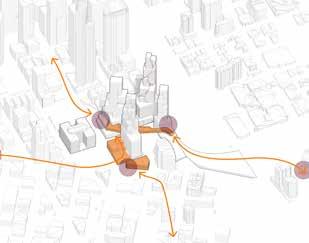
15 Pioneer
square is connected to the International District through a sloping plaza Yesler Linkway is reimagined as an accessible public space connecting neighborhoods.
The frontage of Goat hill Garage is envisioned as a performance space and amphitheater
Beyond the University
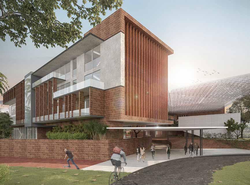
Location : Manipal, India
Type : Campus Planning, Institutional Architecture, Landscape Planning faculty of architecture campus
Competition Entry
Collaborators - Aditya Puri, Nihal Saldanha, Rashmi Ravishankar
Role - Design development, Modelling and Visualisation
Timeline- June 2018- August 2018
Area - 145000 sqft
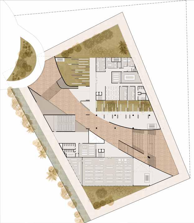
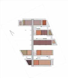
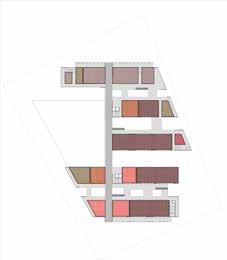
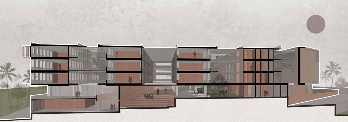
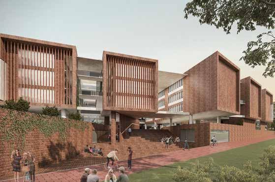
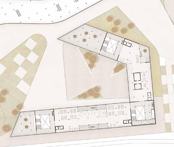
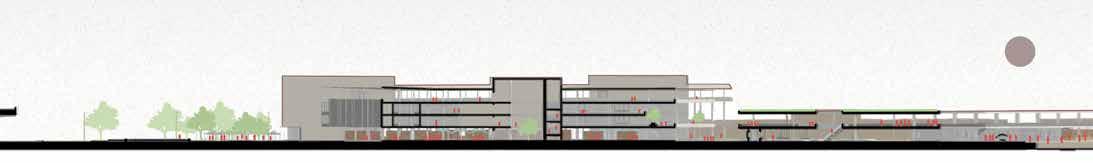
The competition was conducted by the Manipal trust, a well known educational institution in Southern India to design their new Faculty of Architecture block at the university town of Manipal along the western coast of India. The program was to cater to a total of 2500 students for a variety of tracks including architecture, interior design, urban design and fashion management. The site profile provided was a skewed rectangle and had a single approach road. The design sought to create a unique student experience which was based on a central spine which ran along the diagonal of the site. Using this as the datum, the faculty blocks were placed around and over it. Manipal has a hot and humid climate with heavy rainfall for 5 months of the year. Hence, the interaction zones are all enveloped by green and are semi covered. Green sleeves are provided in equal proportions in between the blocks to create more accessible scales between the user and built. The primary construction material used is laterite stone, available locally and is combined with concrete and metal frameworks to create a heterogenous aesthetic to the design. The entry plaza is covered by a space frame truss.
16
Planning and Massing Idea
Using site setbacks and building completely with only two floors.
Splitting up building blocks to create green corridors and reduce scale.
Recessing building block and increasing height to achieve 50% green cover.
Reorienting blocks along NESW direction to maximise natural ventilation .
Landscaped courts in between building blocks to allow for natural ventilation and light. Creating a seamless movement along the ground plane with the courtyards interacting with each other.
Shifting volumes to create courtyards at varying levels and allow for natural ventilation and light to lower levels.
17
1. Entry 2. Reception 3. Admin lobby 4. Consultancy cell 5. Quality and training 6. Joint Director 7. Director 8. Records 9. Board Room 10. Admin Office 11. Examination Office 12. Research and Collaboration 13. Toilets 14. Auditorium 15.Submission & Documentation 16. Library 17. Stock room 1 2 3 4 5 6 7 8 9 10 11 12 13 13 15 DN 16 17 18 14 GROUND FLOOR
Program and Sectional Logic
The building program is equally distributed among the first, second and third floor. While the first floor is mostly for undergraduate programs, the third floor is dedicated mainly to the graduate programs. The second floor in between is provided with workshops and common classrooms.
The admin block is also repeated on all floors as per the faculty with a direct connection to all the academic spaces. The green spaces act as buffers between the blocks and thereby provide individuality and identity to each space while still having an overall similarity in terms of aesthetic. These green zones act as interaction spaces between the classrooms.
The splitting of the blocks allows for crossventilation of all the classrooms and ample amount of sunlight throughout the day.
18
Administration +Faculty B.Des Interior Design Fashion Management Restrooms Masters - Architecture Masters - Urban Design Common Classrooms Canteen Library and outdoor deck Amphitheater Landscape court Faculty zone Interior Design Workshop
19
Amphitheater and view of blocks from southern side.
Shaded landscaped court and connecting spaces
Connecting corridor and green lung space between the blocks
Post
Locker and presentation zone on upper levels with skylight
Visualization and
Processing
The Threshold Hub
urban-rural interlink
Location : Bangalore, India
Type : Mixed use, Ecological Planning
Undergraduate Thesis
Semester 9, B.Arch; School of Planning and Architecture, Mysore
Role - Complete Project
Timeline- June 2016- December 2017
Area- 22.2 acres
Urbanisation is a process which reshapes the way a country functions and has the ability to affect their economies, both positively and negatively. This phenomenon occurs everyday, with each city growing in size, global outreach and demand. When the regional boundaries of these cities are increased to accomodate the growing demands of urban development, they consume the peri-urban and fringe areas in the process. The life of the people in these areas is often neglected citing a “better tomorrow”. However, it results in non inclusive growth which fails to integrate the various classes of population constituting the city. If we are to change this trend, we have to refine our outlook towards urban development and establish ways to create inclusive growth. The project deals with creating inclusive and integrated growth by providing equal opportunities and benefits of the urbanization process. The threshold hub refers to an urban-rural interface campus which is located at the urban rural threshold. The project aims to decongest the city center and provide a nucleus in the direction of sprawl. Instead of negating the existing population, the built framework is used as an instrument to bring people together.
20
The site is located to the north of Bangalore city on the way to the international airport opposite a town called Chikkajala. The Chikkajala lake is located north of the site. It is along the proposed hyper corridor from the city center to the airport and will be part of the economic boom by 2030. ©
STRATEGY PLAN
BUILDING HEIGHTS


21
Site Location and Analysis
Vemaps.com
TERRAIN CLASSIFICATION
ROAD NETWORK SLOPE ANALYSIS
Ground Agricultural land Ridge lines Highway Steep slope Low Income Group G+1 Unused Agricultural/Buildable Primary road Buildable/Intermediate Middle Income Group G+2 Quarry land/mound Secondary road Gradual High Income Group Public building G+3 Lake bed Tertiary road Man made trail +895M +900M +927M
TERRAIN
ECONOMY
THE URBAN CONDITION THE PERI-URBAN CONDITION 1. Proposed Site Location 2. Chikkajala Lake 3. Decathlon complex 4. Metro station 5. Quarry hillock 6. Agricultural land 7. Proposed town expansion 8. Proposed Apartments 9. Chikkajala town 1 2 3 9 4 4 5 6 7 8 Railway line Towards Bangalore centre Towards airport METRO LINE FARM LAND APARTMENTS EMPLOYMENT AIRPORT LAKE REJUVENATION
Design Development- Reconfiguring the grid
CONNECTING NODES-CREATING SPINES
CARVING PATHS AND SPACES
DISTORTING THE BUILT-FORMING STREETS

RAISING BUILT-BLURRING BOUNDARIES
22 SECTION A-A’ Coworking terrace Business Plaza Coworking spaces Main spine Auditorium Auditorium drop off Elevated highway Lobby and Atrium +18.0m +4.5m +11.0m
ESTABLISHING THE GRID BUILDING BLOCK ORIENTATION
Site Planning and Internal Program
23
1. Retail kiosks +landscape 2. Water feature 3. Coworking main lobby 4. Start up exhibition kiosks 5. Coworking inner plaza 1. Workstations 2. Restrooms 3. Meeting rooms 4. Outdoor meeting space 5. Lobby and Atrium 6. Art installation zone 7. Rural handicraft kiosks 8. Food court and kitchens 9. Multipurpose hall 10. Agrohub 6. Informal meeting area 7. Information 8. File storage 9. AV room 10. Outdoor deck 11. Loading/Unloading 12. Allotment Gardens 13. Waterfront Amphitheater 14. Library 15. Event lawns 11. Conference space +4.5m +8.5m +12.5m +18.0m 16. Auditorium pre function space 17. Auditorium 18. Event lobby SITE PLAN AT +1.2M SECTION B-B’ PLAN OF COWORKING HUB AT 4.5M (TYPICAL FLOOR) 1 1 1 1 2 3 4 4 5 5 5 6 7 8 9 10 10 11 4 2 4 5 6 7 8 9 10 11 12 13 14 15 16 17 18 19 3 B A A’ B’ Water feature+plaza Retail kiosks Louvered facade Coworking spaces Atrium Outdoor meeting area Food court green roof Viewing Deck Lakefront walkway
The Coworking Hub is designed as an open plan which responds to the on site grid and allows for green pockets in and around it. It is envisioned as an accelerator for start up businesses. The interiors are kept as flexible as possible and provided with plenty of natural light. The ground floor is kept open for the public to interact with the users of the space, thereby creating a unique experience. The ground floor comprises of start up exhibition kiosks and product launches around a business plaza which attract customers.
24
The spines are dotted with street furniture which have been designed keeping in mind the zones they are located in. They are a combination of a permanent base and a changeable, flexible add-on to suit the user’s needs. These furniture kit of parts add character to the open spaces.
RETAIL + SHOP KIOSK
This kiosk typology is placed along the spine at the entry to cater to smaller retail brands. The base is set up and temporal kiosk shelters can be fitted in modules.
HANDICRAFTS+ART DISPLAY KIOSK
The base with tensile roof is added to modular shelving and display units. The front desk also becomes a part of the modular system. These are located towards the town entry towards west to promote rural handicraft and art sales.
EXHIBITION AND PRODUCT LAUNCH
The base comprises of a metal framework which is clad over and is provided with electrical points. Front desk and a display screen are added to it. It is located below the coworking zone and is for startups to present their products to customers.
FARM PRODUCE STALL
The platform is designed in such a way as to replicate the traditional Indian vegetable or fruit seller’s stall standards. Display shelves and a front desk are added. This is located below the agro hub to help farmers sell their produce.
25
+ + + +
Entry
South
of
Street Furniture Typology
Interior space of a typical floor in the Coworking Hub
Plaza towards
with View
Coworking Hub
Navigable Neighbourhoods
Bicycle Mobility plan and Docking station Design
Location : Mysore, India
Type : Mobility Planning ,Transit Design
Academic School of Planning and Architecture in collaboration with DULT and Prof Vinayak Bharne, USC School of Architecture
Semester 8
Area- 4.5 acres
The Directorate of Urban Land Transport (DULT) conducted a workshop which revolved around developing a master plan for a bicycle network in Mysore. The masterplanning was done carefully taking into account various factors of the city including accessibility, heritage and existing transport services. As such, design interventions/ inserts were needed to help boost the masterplan at strategic locations. The two projects have been chosen by DULT for implementation after the masterplan and the Public bike sharing system got a nod of approval from the state government. This makes Mysore India’s first bicycle friendly city and these projects are an integral part of the same. The first intervention is converting the city’s university campus street into a pedestrian street which would host flea markets, events and art installations. The second intervention placed at the entry to the the lake, is the main docking station and information kiosk for the city which would help customers redeem their bicycle rides for coupons and gifts as an incentive. The location also repurposes an old horse carriage stand as the docking area for the cycles.

26
STRATEGY PLAN
PUBLIC MOBILITY
The areas of intervention are chosen based on their proximity to the State university, accessibility from residential neighbourhoods and interaction with the lake. The bicycle path is designed as an alternate network which takes the user from the palace located at the center of the city to main university campus street through residential neighbourhoods and green areas. The path has been designed so as to carefully avoid the state highway and allow access to it only when absolutely essential. Along the path, the experience is dotted by heritage buildings, green areas and well-lit paths. This strategy hopes to promote the use of bicycles in Mysore.
The lake becomes the focal point of the intervention with prime emphasis on the roads located adjacent to it. The lake road to the south and the campus road to the west are considered for the traffic analysis.


27 Site Location and Strategy
FIGURE GROUND 5 am - 9 am 11 am - 6 pm 7 pm - 11 pm 1. Mysore Palace 2. Commissioner’s office 3. Railway Junction 4. Kukkerhalli Lake 5a. Intervention area 1 5b. Intervention area 2 6. University Cricket ground 7. University Hostels 8. Heritage Museum 9. University Auditorium 10. Admin Office 11. State highway Docking station Bus stops Buses Cars Trucks Motorcycles Bicycles Intervention zone Primary bus route Secondary bus route Well lit streets Residential Institutional Dimly lit streets Proposed Plaza Docking station Bicycle path (palace road) Bicycle path (lake road) Heritage block Residential block 1 2 3 4 5a 5b 6 7 8 9 11 10
TRAFFIC ANALYSIS PEDESTRIAN SAFETY BUILDING TYPE
The Campus street - Pedestrian friendly neighbourhoods

PEDESTRIAN FOCUS
The campus street is reimagined as a pedestrian and bicycle friendly gathering space for the neighbourhood as opposed to a transition space. The setting up of temporary flea markets helps bring the community together. The proposal also promotes art events and installations which help the university students showcase their work. The street is provided with street lights throughout and thereby becomes an active public space.
The lakefront plaza is designed to create a subtle transition between the streetscape and waterbody through a series of public spaces, landscapes and event zones. The meandering path leads to a variety of activity zones such as the amphitheater, graffitti walls and kids’ play area. The docking station is located at the plaza and caters primarily to the students of the university. EXERCISE+PLAY
28
EXISTING ROAD SECTION PROPOSED ROAD SECTION
Plaza
Proposed landscape 5. Kids’ play zone 6. Amphitheater 7. Viewing area 8. Lake 9. Cricket Stadium 10. Bicycle path 1 2 3 5 6 7 8 9 10 4
COMMUNITY PERFORMANCE 1. Pedestrian street 2.
3. Landscape feature 4.
The Docking Station- Incentive to cycle
2. Information desk/server
3. Docking station
4. Public plaza
The main docking station is located at the primary entry to the Kukkerhalli lake which is thronged by visitors from the nearby residential neighbourhoods and various parts of the city. The location makes the docking station a landmark and easily accessible. The shaded plaza also provides a resting space for lake-goers after their walk. The information kiosk within would offer user details regarding the mobile app, theft, general maintenance, service and reclaiming their bicycle miles for gifts, coupons etc.
The docking station is placed within an old, dilapidated ‘tonga’ stand which is the local shelter for horse carriages. These shelters were found throughout the city during the rule of the Maharaja and have been abandoned. Repurposing the stand allows the idea of a transport oriented shelter to continue, albeit through bicycles. The connection between the two lake docking stations allows for people to cycle around the lake as well.
29
PLAZA + REST LAKE ACTIVATION INFORMATION
1 2 3 4 5 6 7 8 9
1. Information kiosk lobby
5. Bicycle and pedestrian crossing
6. Landscaped Lake entry
7. Car parking
8. Lake path
9. Railway crossing
The Insta Home
Location : Varied / across India
Type : Modular Homes/ Design for Dissassembly modular housing solutions for India
Professional+ Research Sanctuary Architects and Designers www.sanctuaryarch.com
Role - Core Design team; Cost optimisation; Visualisation; Branding; Detail drawings.
Timeline- March 2018- August 2021
Area - 160 sqft - 360 sqft
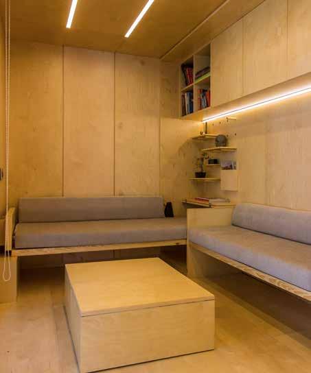
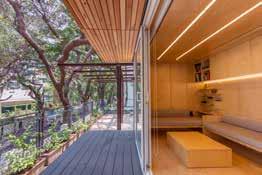
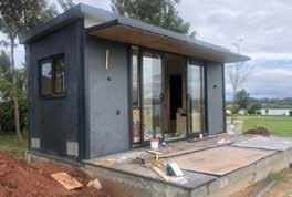
India in the last decade or so has been faced with a unique urban situation - where the urban fabric is transitioning towards a global economy while on the other side, the lack of effective building solutions to facilitate this change has hindered the process. Current residential typologies in Indian cities are still based on concrete and thereby lack flexibility of use and construction. The urban demographic are unwilling to accept a change in terms of construction methods and design language. The Zen Den project aims at providing a solution to this through an efficient and modular housing/building typology based on lightweight and fast construction, flexibility and adaptability to existing built contexts and a customisable interior. The design is envisioned as a symbiotic architectural language to existing urban and rural conditions. The project aims at providing a solution to this through an efficient and modular housing/building typology based on lightweight and fast construction, flexibility and adaptability to existing built contexts and a customisable interior.
30
The Construction
Part 7b. lightweight galvalume roof
Massing modules
Single unit
Part 7a. internal birchwood boards with expansion joints
Part 6. internal birchwood boards with expansion joints
Part 5. roof and false ceiling metal framework.
Part 4. vertical metal framework and supports
Part 3. exterior cement boards
Cluster Dwellings
Multi Storeys Landscaped modules
Reimagining the deck
Mixed-use iterations
Dimension variants
20x10 - live/social/work
36x10 - extended live
Part 2. floor and wood plastic composite deck framework
20x14 - resort
Part 1. concrete pilasters fixed to the ground
40x15 - entertainment lounge
31
+
The Details
30mm thick corrugated galvalume
primary galvalume roof fixed to 50 x 50 metal sections with polywool insulation
4mm thick continuous gutter provided on the rear side
flap provided in interior panelling to accomodate air conditioning unit
Sink and interior pantry counter fixed onto 9mm thick fiber
Air conditioning outdoor unit clamped onto external wall
secondary galvalume roof fixed to 50 x 25 metal sections with pine wood under-cladding
uPVC prefabricated doors with 8mm thick toughened glass shutters
18mm thick fiber cement board fixed over metal framework and finished with 12mm laminate flooring.
20 mm thick porous Wood plastic composite (WPC) planks fixed onto metal framework for decking.
50mm thick polywool insulation
50mmx100mm MS section for room framework
100mmx100mm and 200mm x 100mm MS sections used as lintel and fascia beam
uPVC sliding door section fixed to structural member
20mm thick plywood internal ceiling fixed to roof framework
uPVC sliding door section fixed to structural member
12mm thick laminate flooring fixed onto 18mm thick heavy duty fiber cement board
20mm thick WPC planks fixed onto 50mm x 25mm metal deck framework.
Detail B Detail C
400mm radius concrete pilasters
100mm x 100mm GI gutter fixed onto roof sheet
100mm x 200mm MS beam
9mm fiber cement board as internal board fitted with 20mm thick birch wood panelling
40mm x40mm vertical MS member as interior support
32
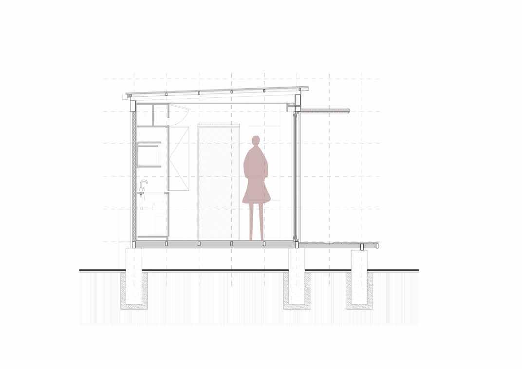
framework in 2’ x 2 ‘ grid modules assembled at site. Floor framework could either be a plinth or metal fabrication depending on the requirement. External weatherproof boards are fixed to the framework and 4mm thick insulation is provided in between and prevents excessive heat entering the den. The interiors and exterior cladding are added as the final step, with windows and doors completing the product. The timeline for the entire process is 30 days.
Structural
A
Detail A Typical Cross Section Process
B C
The interiors are designed to accommodate as many functional aspects as possible within a restricted space. By replicating the modular grid within, the interiors are easy to assemble.
By introducing flexible furniture such as fall down or murphy beds and movable tables, the den transforms as per functional and user based requirement.
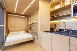
Flexible interiors which fit within an easy to assemble exterior make the den the right alternative for temporal structures.
33
Beyond the Residence 08
residential facelift
Location : Hyderabad, India
Type : Adaptive Reuse, Residential Architecture
Professional Sanctuary Architects and Designers www.sanctuaryarch.com
Role - Project lead
Timeline- August 2018- September 2021
Area - 10000 sqft
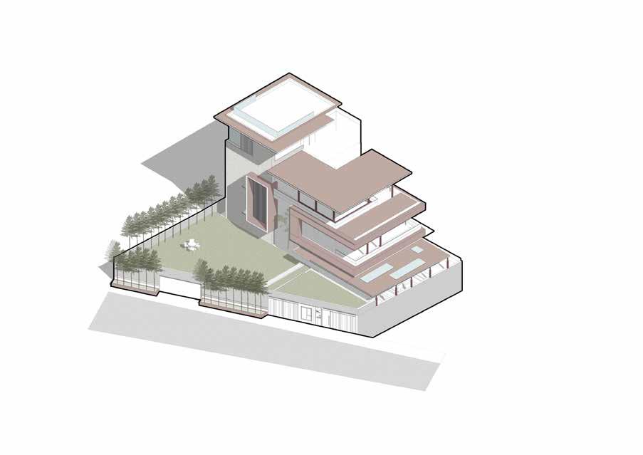
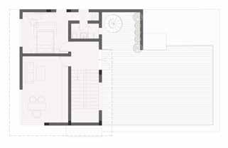
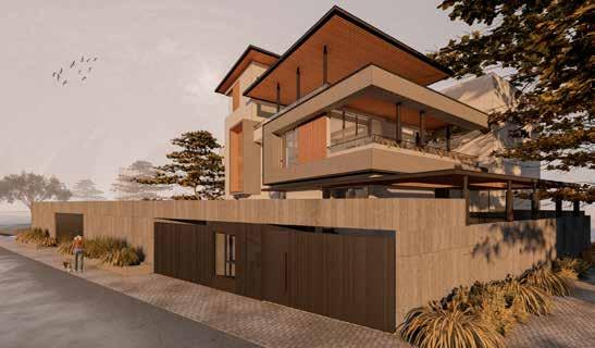
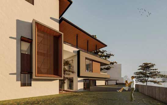
The project brief required an existing, dilapidated structure to be transformed into a private residence in an upscale neighbourhood of Hyderbad, India . The existing structure consisted of two main masses separated by a courtyard and lacked any aesthetic direction. The design proposal was in two stages, one which involved the structure itself and the other mainly towards the context. In terms of the building, an extra floor was added to the western mass and a series of roofs were juxtaposed onto the volumes to create a cascading terraced form. By introducing these terraces, the open terraces became usable shaded decks filled with landscape . Facade elements were introduced to cover and mute the staircase area and combine the volumes. A material palette of wood, concrete and local basalt stone was used for the exterior to achieve a contextual tropical modern style of aesthetic. In terms of the context, a basement was provided as a split level and the top of this basement was made a large lawn and spillout for the ground floor. On the opposite side of the street, with the client’s and government approval,the barren land was developed into a community park.
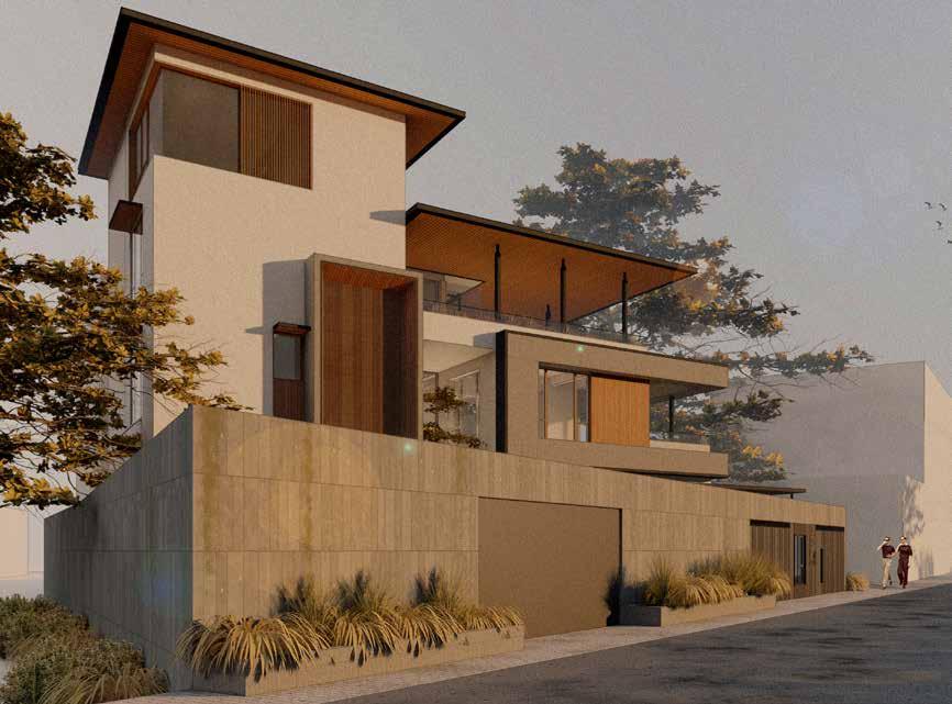
34
The Process
EXISTING STRUCTURE
The existing structure consisted of two main masses separated by an open court in between. The building itself was at a height of 1.5m above the road level and was oriented 45 degrees away from the road line. The surrounding landscape was barren and was home to anti social activities.
Added Canopies
Retrofit Facade
Split level podium
PROPOSED TRANSFORMATION
The proposed transformation is based on the utilisation of open terrace spaces as shaded decks through the introduction of canopies. These canopies add to the external aesthetic of the building and increase its scale. The split level podium provides the residence with a basement car park and a large lawn.
Existing massing
Added floor and slab
Added canopies
35
Added facade elements Lawn and lift core Extension of green as park
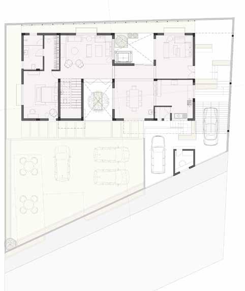
The transformation of the external volume was followed by the repurposing and repositioning of the interior spaces. The exsiting structure’s mass meant that functions had to be stacked on on top of the other. The ground floor was provided with social, living and dining spaces which opened into the lawn. The upper floors were more private with bedrooms and private entertainment zones.
36 Internal Program
GROUND FLOOR CROSS SECTION THROUGH COURTYARD -1.00 m +1.90 m +2.35 m +5.35 m +8.35 m +11.35 m +14.35 m 1. Car Park 2. Security Cabin 3. Entry Porch 4. Foyer 5. Sit-out 6. Dining 7. Kitchen 8. Utility 1. Car Park 2. Open Lawns 3. Double height courtyard 4. Formal living 5. Corridor 6. Son’s bedroom 7. Private Bar and Lounge 8. Outdoor Lounge 9. Courtyard 10. Elevator 11. Courtyard 12. Formal Living 13. Powder toilet 14. Bedroom 15. Bathroom 16. Open lawns 9. Clothes’ Drying yard 1 1 2 3 4 6 7 8 9 5 2 3 4 6 7 8 9 10 11 12 13 14 15 16 5
37 Internal Program FIRST FLOOR SECOND FLOOR THIRD FLOOR
Extended lawn from courtyard providing a private green space for the residents. 1. Staircase 2. Master Bedroom 3. Master Bathroom 4. Son’s Bathroom 5. Son’s Bedroom 6. Elevator 7. Prayer/Puja room 8. Family lounge 9. Outdoor deck 1. Staircase 2. Home theater 3. Powder room 4. Pantry 5. Bar and Lounge 6. Elevator 7. Outdoor lounge 1. Staircase 2. Home office 3. Guest Bedroom 4. Bathroom 5. Drying Yard 6. Future expansion of terrace 1 1 1 2 2 2 3 4 5 6 3 4 5 6 7 3 5 4 7 8 6 9
View from Eastern side with terraces and added canopies
The Transformation
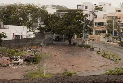
The existing parcel of land opposite the site was being used as a dump and was subject to anti social activities. Our proposal included the soft landscaping of the edge and allowing for the development of a park along with street lighting along the edge and corner
The existing structure was dilapidated and was open to the street resulting in illegal activities. By introducing a green buffer and raising the built on a podium, both privacy and an active green public interface were achieved.
Locally available teak and basalt were used as the main exterior materials and rooted the design to its place.
38
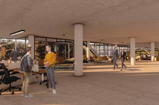
Summer Internship 2023
EvolveEA
Location : Pittsburgh, Pennsylvania
Type : Community Engagment, Urban Design, Graphic Design, GIS Mapping
Master of Urban Design; Role - Designer + Analyst
Timeline- May 2023-August 2023
evolveEA is a nimble multidisciplinary practice situated at the intersection of sustainability and the built environment. They help individuals, communities, and organizations take strategic action.
As part of my internship at this esteemed practice, I was able to work on a variety of projects ranging from architectural drawings , urban design and community planning to LEED building certification and GIS oriented analysis.
Areas of Involvement : 3d modelling, Community Charrettes, Architectural details, GIS analysis, LCA analysis, Presentation Graphics, Report writing.
39
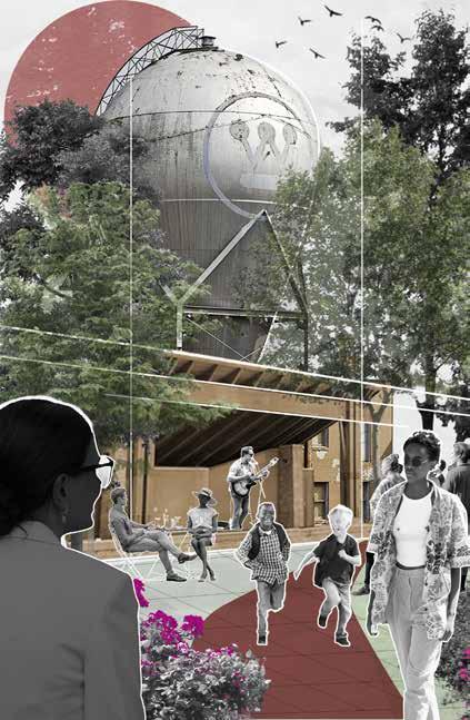
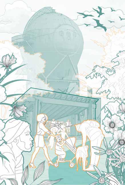
Posters made for a Community meeting and Charrette at Forest Hills, PA ; The plan was to reimagine the Westinghouse Atom Smasher and its surrounds as a vibrant community space.
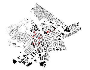
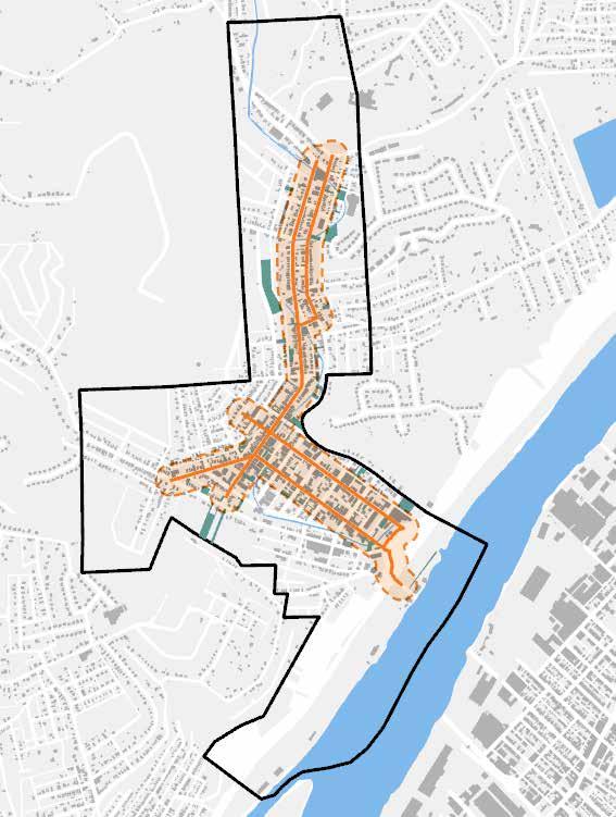
Reassessing Millvale’s Business District
As part of the ongoing vision of the Allegheny Together project, EvolveEA has played an important role in reassessing the business districts of many underserved communities across the county. One such community is Millvale. An important public anchor in the community is the Millvale Park which is currently underutilised.
40
Analysis of Millvale main street and potential city owned parcels that could be leveraged for transformation.
A vision for the Millvale Park as a vibrant public space and temporary music venue
LEED Oriented Work
EvolveEA are industry leaders and experts in addressing the sustainability requirements of various projects. As part of this, it involves accreditation of buildings for LEED certification. Neighborhood Density points and Life Cycle Analysis form two important ways of achieving the same. Athena wbLCA was used for the calculations.

LEED
LCA Measure Comparison Report Cradle to Grave (A to C)
Reference Design: UPitt Baseline Building
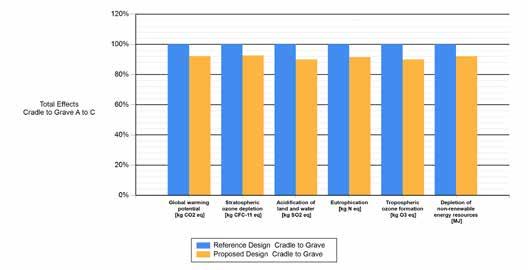
LEED LCA Measure Comparison Report Cradle to Grave (A to C)
Reference Design: UPitt Baseline Building
LEED Urban Density analysis conducted for a design scheme in Oakland, Pittsburgh.
Whole building Life Cycle Analysis successfully incorporated and calculated for design scheme in Oakland, Pittsburgh.
41 Residential Non-Residential Building Types Site Density Zone Boarder Site Density Zone Site Buildable Area within 1/4 mile of site: 172.4 Acres Residential Area: 1,089672 SqFt 6321 SqFt/Acre Non-Residential: 12,715238 SqFt 73,754 SqFt/Acre Building Area Combined: 13,804,910 SqFt 80,075 SqFt/Acre Green Space (Exempt) County of Allegheny, West Virginia GIS, Esri, HERE, Garmin, GeoTechnologies, Inc., USGS, EPA, Esri, HERE, Garmin, (c) OpenStreetMap contributors, and the GIS user community 0 0.22 Miles ¯
Page 1 of 2 Printed By: KOUSHIKLEGION\koush Printed On 7/6/2023 11:11:33 AM
UPitt SHRS Interior-01 Proposed Design: Summary Measure Unit Reference Design Total Effects Cradle to Grave A to C Proposed Design Total Effects Cradle to Grave A to C % Difference Global warming potential kg CO2 eq 4.84E+07 4.46E+07 -7.84% Stratospheric ozone depletion kg CFC-11 eq 4.19E-01 3.88E-01 -7.29% Acidification of land and water kg SO2 eq 2.40E+05 2.16E+05 -10.07% Eutrophication kg N eq 2.53E+04 2.32E+04 -8.44% Tropospheric ozone formation kg O3 eq 4.37E+06 3.93E+06 -10.03% Depletion of non-renewable energy resources MJ 7.05E+08 6.49E+08 -7.93%
UPitt SHRS
Proposed
Interior-01
Design:
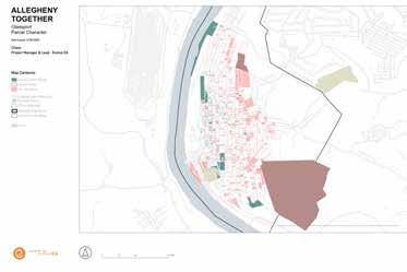
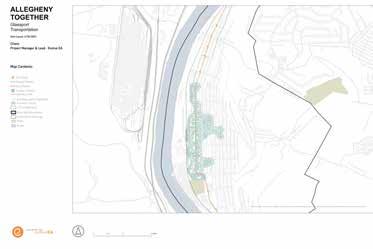
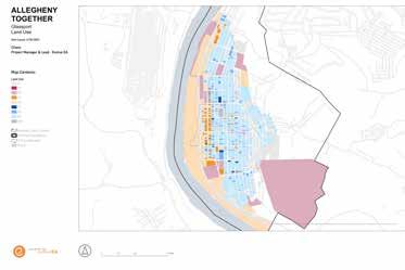
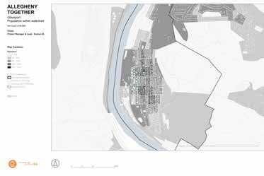
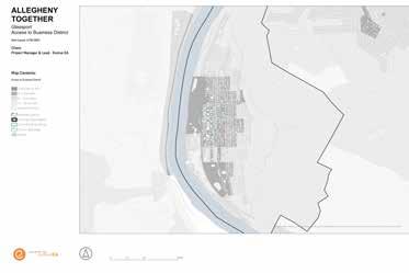
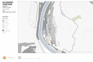
Allegheny Together - Mapping Vulnerable Communities
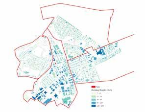
Allegheny Together is a program that provides strategic planning and technical support for traditional business districts throughout Allegheny County. EvolveEA helped reestablish the program with an updated model and provide on-going planning services to strengthen communities across the county. In my capacity of an analyst, I was able to use GIS as a method of conducting this for multiple communities including Glassport, PA shown here. These maps indicate building occupancy, mobility networks, building condition, ecological boundaries/zones , access to economic resources etc.
42
Reclaiming Platform Futures
Location : Bangalore, India
Type : Urban Design, GIS Mapping, Research
Master of Urban Design; Ongoing Thesis Semester 3+4, MUD; Carnegie Mellon School of Architecture, Individual Project
Timeline- August 2023-Ongoing
Awards : George W Anderson Award
Runner up; Microgrant secured for further research from the Studio for Creative Inquiry, Carnegie Mellon University Research into Platforms and their future in Bangalore, India
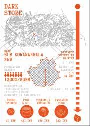
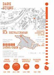
My thesis project explores the impacts and technological disruptions of platform urbanism in Bangalore, India. Platforms like Uber Eats and Swiggy have disrupted the ways in which citizens negotiate and interact with food. Food from 10-15 kilometers away can reach one’s home in less than half an hour. These platforms are not just present at the point of food delivery, but infact have made their way up the food supply chain – changing ways in which farmers and various other wholesalers and warehousers interact with consumers. All these disruptions are facilitated by the ever present ‘gig economy’ or gig worker.The establishment of warehouses on the outskirts which go beyond the land use and logic of regular/ open government markets – which are accessible to wholesalers and retailers alike. Analysis shows how the digital and physical spaces of the city intersect in a multitude of ways.


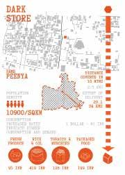
43
Industrial Warehouses and Storages Supermarkets and Hyperlocal Markets Consumer Dark Stores and Microwarehouses Neighborhood Stores Kiranas Local Restaurants Wholesale Dealers HORECA Farms and Farmers Industrial Warehouses and Storages Supermarkets and Hyperlocal Markets Consumer Dark Stores and Microwarehouses Neighborhood Stores Kiranas Local Restaurants Wholesale Dealers HORECA Farms and Farmers Industrial Warehouses and Storages Supermarkets and Hyperlocal Markets Consumer Neighborhood Stores Kiranas Local Restaurants Wholesale Dealers HORECA Government Markets/Mandi Distribution Centers/ Sub Yards Farms and Farmers Probable Future Existing Scenario Original Condition 10 km 20 km 10 km 20 km 5km min 10 min Average Time to Drive 10 km 40 mins Dollars per delivery hrs minimum daily kms minimum daily Dollars as daily income Dollars for fuel 0.35 12 160 12 Minimum Wage in Bangalore 6 5 15 min 5km Delivery Charges Restaurant Commissions Conceirge and Groceries Data Sales Modes of Income Platform Memberships 120 MILLION Orders per month 1.2 MILLION Orders cancelled 2.1 KILO TONNES Food waste every month 3000 PEOPLE could eat everyday for a year 9 LITRES WHAT’S IN AN ORDER?? Fuel Wasted on every cancellation 40 kms A Meal’s Distance 20 kms 10 kms Modes of Platform Intermediation Exchange between Buyer and Seller Value creation through “sharing” of goods and services Engineered conditions of exchange and data capture App owned Warehouses Platform owned storages and warehouses have substituted conventional markets and “mandis” and they are constructed on peripheral farm lands, usually on 10-20 year lease. Government Markets Mandi’s or Yards are government owned properties which rent spaces out for various agencies which function as intermediaries between farmers and wholesalers, HORECA and other buyers. They often feature large open space for gathering and auction. Motorcycle and bike repairs and accidents are common occurences on the job as the workers have to keep up with the time limit despite severe weather conditions and traffic. Delivery workers are extremely reliant on their cellphone connections and data service. They don’t have a dedicated space of refuge or gathering either. Bangalore has the second worst traffic congestion in the world. On an average, an individual spends 260 hours in traffic. Gig workers are forced to work in these conditions daily. Most gig workers in the food platform economy are migrant workers and reside outside the city limits. Despite being involved in the food industry, their own families do not have food security. In neighborhoods like Koramangala, food platforms have established strong customer bases and over time shifted their culinary preferences. These patterns have resulted in local stores having to join the platform economy to survive. Informal stalls and food vendors are often excluded from platforms. However, they play an important role in providing for the gig workers on daily basis. Mid Sized Dark Stores Many mid sized dark stores take up land in disinvested communities of Bangalore. These stores often stand in stark contrast to the context and utilise labor from the neighborhood. Many times, functions such as hostels and housing are provided on the higher floors The Neighborhood Dark Store Platforms such as Swiggy and Zepto have rented out office space in many neighborhoods and set up dark stores. There are no laws which govern the setting up of such stores as opposed to traditional warehouses. Often, they mimic office buildings and stay hidden. Cloud Kitchens and Restaurants At the front end of the FSC of platforms are restaurants and platform owned cloud kitchens. IWhile restaurants could have varied sources of supply, cloud kitchens have emerged in various neighborhoods and tilt the patterns of consumption in their favor.
Bangalore, India Koushik Srinath
RECLAIMING PLATFORM URBANISM
Actor Network Analysis and Speculative Futuring
Analysing the various actos of present along the food supply chain, it is evident that there is a parallel economy to one which exists on our phones.Using speculative futuring as a method, the project aims to look a wide range of ways in which the platform economy can be made equitable including data sovereignty, reinterpreting the dark warehouse as an architectural type and commoning of shared resources between platform cooperatives.


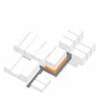


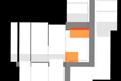


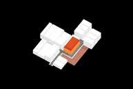


44 Industrial Warehouses and Storages Supermarkets and Hyperlocal Markets Consumer Dark Stores and Microwarehouses Neighborhood Stores Kiranas Local Restaurants Wholesale Dealers HORECA Farms and Farmers Existing Condition Neighborhood Impact and Thresholds of Counter Practice Artifacts of the Gig Economy Picking, Sorting and Treating Produce and harvest is sorted as per each platform aggregator’s daily requirement. Packaging and Placement Food is stored and placed in dark stores as per consumption patterns. The most in demand products are placed in the front. Gathering at Fuel Stations Fuel stations are points of contact for delivery workers as they are also locations of bike repair and conversation. Gig workers are required to pay for their own fuel Planning of the Dark Store Case of Dark Store in Koramangala Delivery Backpack Typical Packaging Modules Brand uniform and Helmet Mobile Data and Earphones Taping and Branding Food Street Carts and Motorcycles New Digital Districts Platforms have reorganized the city through the formation of new districts based on shifting proximities. Dark stores and restaurants have established radii based on consumption patterns and data analytics. Proximity Unpacking the Platformification of food has changed the nature of what local and locality mean, shifting it from one of physical proximity and local subjects to that of digital convenience and remote consumers. Interaction with Street Vendors Delivery and warehouse workers rely on street carts and informal vendors for their food, coffee etc. Local delivery as counter Many local supermarkets have started to use their own local delivery services which are slower but form a more reliable network and understanding. Speeding as Norm Storage and Office Loading Zone 1 1 4 Street Vendors Least Consumed Most Consumed The dark store typology operates typically in warehouses or buildings with an area of 5000 10000 sqft within neighborhoods. They have redefined standards within tighter space and automated sorting.The windowless facades have changed hollowed out neighborhoods, creating dark voids in the urban fabric. Order Reception and Packaging 2 Backend Storage 3 Office 4 Stacks and Shelves The gig worker Gig workers are veiled by the platform once they log in. Their lives are often dictated by the action of logging in and logging off. Waiting outside on benches/steps The thresholds outside restaurants and stores become important spaces of gathering for these workers. They form a new hybrid public space. Modular Packaging and quantities Restaurants are forced to buy food packaging from third party vendors. They also end up tailoring their food to the demands of platform consumers. Automobile Motorcycle 15 mins 0 miles 15 mins 0.75 miles Walking Cycling RECLAIMING PLATFORM URBANISM Bangalore, India Koushik Srinath RECLAIMING PLATFORM URBANISM Bangalore, India Koushik Srinath Reduced Proximities and Soft Mobility Data feedback between more proximate infrastructures, facilitating sharing of resources. Landuse Regulations and Byelaws Design guidelines and byelaws for the setting up of dark stores and other food facilities. Consistent Setback Efficient Energy Systems and Code Access to Open and Public Space or Roof Agro Building Height Restrictions Community based location Access to Food Storage Data Adapting Dark Stores, Thicker Thresholds What dark stores were reimagined with more porous thresholds, allowing for shop fronts for street vendors and waiting zones for delivery workers. Platform Co-operatives P2P and Co-op with Co-op as platform alternative to the current model, allowing for more localised platforms and distributed networks. Allows for price control and sharing of surplus among cooperatives. Producers Consumers State Regulation on Platform Intermediation Data used for restaurant resources. Taxation of platforms operating in neighborhoods or occupying commercial property. Delivery Charges Employee Salary and Benefits Restaurant Resource management State Tax, Local Municipal Tax Platform Conceirge and Groceries Restaurant Commissions Data Sales Modes of Income Memberships Fair work and Benefits Employee Status and Rights for gig workers. Consistent Pay irrespective of logging in or logging off. Medical leaves, vehicle and risk management, technical assistance. Gig worker Welfare Board and social security. Fair Work Platform Welfare Board Worker Organization Redressal Mechanisms Lateral Deep Scaling Respect and Privacy Participation in Decision making Medical coverage and Insurance Salary and Data Security Opportunity grow Rider Hubs and Worker Infrastructure Supportive facilities and spaces for the workers to meet, organize and other daily needs. These would be integrated into the planning of community food storage facilities Data Access and Sovereignty Producers Consumers Data feedback without capture, creating Producer to Consumer feedback loops. Consumer to Produser as model. Data Privacy and Security and new forms of digital infrastructure. Food Rescue Hubs and Neighborhood Food Commons Recovery of cancelled food orders and wasted food can be collected and redistribute throughout the neighborhoods. Integrated Community Farms and Gardens The rooftops of darkstores and open spaces around existing ones can be used to facilitate local farm programs. Years Years 2.5 Years 10 Years 10 Years 20 Years 20 Years 20 Years + + + + + + + + + + 25 Years
An Atlas of Commoning
Research and Field work to advance research on the urban commons
Location : Tbilisi, Georgia | Pittsburgh, Pennsylvania
Type : Urbanism, Community Engagement, Field work
Master of Urban Design; Ongoing Research Semester 2-4, MUD; Carnegie Mellon School of Architecture, Timeline- August 2023-Ongoing
Through intensive fieldwork in Tbilisi, Georgia, this ongoing research project aims to add to the already diverse range of examples found in An Atlas of Commoning, an effort at documenting and bringing to light various commoning practices from across the world.
As part of my research with Prof. Stefan Gruber, who heads this effort, I have also started to diagram and expand on various patterns of commoning which exist including spaces, practices and overarching concepts. The work is an attempt at documenting, analysing and bringing to light various, diverse practices which could provide new modes of resource sharing and the production of space, which is deeply rooted in the ideas of ownership-access , productionreproduction and rights-solidarity with the commons as a foundation.
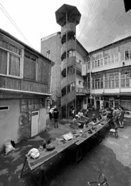
Due to a lack of funds and the complexity of its construction, the residents have been unable to maintain the staircase for several decades. Now with the staircase in an urgent condition, a conservation plan is not within their means of residents, even though some of the neighbors rely on the structure to access their homes. This presents the issue of losing valuable cultural heritage in a city which is rapidly losing its historical character, and an evident hazard to the community.
Since our project has been approved by both the municipal cultural heritage and architectural departments, our plan is to complete the project through crowdfunding in a year. We are organizing a conservation workshop in collaboration with the residents, carpenters, local architects, and conservationists.
The goal was not only to maintain the artefact itself but also to emphasize the significance of activating one element in the courtyard house that can serve to support and preserve the space’s social dynamics.
KIBE PROJECT
Tbilisi, Georgia, 2019
Kibe Project was started to restore an important staircase that was dilapidated within one of the communal courtyards in the historic district of Tbilisi, Georgia. Prior to the soviet period, these courtyard houses or “Ezos” were owned by a single wealthy family. During the soviet period, they were redistributed among multiple families and shared infrastructure such as staircases, courtyards and corridors became an integral socio-cultural aspect of these houses. After the Soviet period, hyper privatization of the courtyard and other communal spaces resulted in the lack of care and maintenance of shared infrastructure.
With many of these houses set for demolition due to gentrification and higher land prices, there was a fear that the architectural and cultural heritage of these Ezos would be lost. The Kibe project is a response to the lack of intervention from the state towards the maintenance and care of shared courtyards.
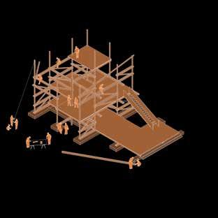
In collaboration with the local municipal government, residents of the homes and Conservation organizations, the project aimed to preserve the historic and cultural fabric of the city while also reconciling the relationships of the residents with the heritage value of the spaces. Through a detailed survey of the staircase, its structure and surrounding geology with the help of volunteers, the Kibe project successfully submitted an architectural proposal to the municipality which was approved. The restoration effort was taken forward with the help of the residents and other volunteers and was completed in a year.
For more information, visit Instagram: @kibe_projekt
45
11
U - Shaped Courtyard Kibe Project L - Shaped Courtyard Caravan Sarai We worked with the residents, architects and volunteers within this courtyard to repair the staircase. We were able to learn and understand historical carpentry techniques together. -Nika Gabiskiria I used to live here and the courtyard was used as a parking lot. The staircase was extremely damaged. We started the Kibe Project as a way to reconcile the residents’ relationships and social dynamicswith the courtyard. -Thomas Ibrahim After the restoration of the courtyard, we have started smaller repair works all around the Ezo. KIBE PROJECT TBILISI, GEORGIA NEGOTIATING EZO/ ITALIAN COURTYARD OWNERSHIP IN OLD TBILISI 19TH CENTURY SOVIET PERIOD POST 1991 Private During the 19th and 20th century, the Ezo houses were owned and occupied by a single, wealthy family. The Ezos were divided up during the Soviet period and distributed among worker class families. The courtyard was a shared space among the families. After the Soviet period, the Ezos have become privatized further through the slow land grabbing of the courtyard. Common/Shared Public AN ATLAS OF CO W W W W W W W W W W W W W W W W W W W W W W W W W W W W W W W W W W W W W W W W W W W W W W W W W W W W W W W W W W W W W W W W W W W W W W W W W W W W W W W W W W W W W W W W W W W W W W W W W W W W W W W W W W W W W W W W W W W W W W W W W W W W W W W W W W W W W W W W W W W W W W W W W W W W W W WWW WWW WWW W W W W W W W W W W W W W W W W W W ONING W W W WWW
COMMON GROUND
Excerpts from the Kibe Projekt, http://www.staircase.ge/about.html, Accessed November 9, 2023. An Atlas of Commoning Orte des Gemenschaffens An ifa exhibition in collaboration with ARCH+, ifa (Institut fur Auslandsbeziehungen) is Germany's oldest intermediary organisation for international cultural relations, having celebrated its centenary in 2017. ifa is supported by the Federal Foreign Office of the Federal Republic of Germany, the state of Baden-Wuttemberg adn its capital Stuttgart. www. ifa.de/ed ARCH+ is Germany's leading publication for discourse in the fields of architecture, urbanism, and related disciplines. www. archplus.net Graphics Design Heimann Schwantes, Berlin © 2018 Institut fur Auslandsbeziehungen e.V. (ifa), Stuttgart, Germany; authors; artists Posters This drawing collage by Koushik Srinath is based on fieldwork, secondary sources, and materials from 1. Kibe Project Website KIBE. (n.d.). http://www.staircase.ge/ kibe.html 2. Tbilisi as Palimpsest Ziaiemehr, Turan. “Tbilisi as Palimpsest: Patterns, History, and Perceptions, in the Formation of a Reactive City,” 2023. 3. Public interview with Thomas Ibrahim and Nika Gabiskiria conducted on October 15th, 2023, in Tbilisi, Georgia A research project by the Master of Urban Design at Carnegie Mellon Univeristy Photo Kibe Project, 2019 PROJECT Revitalizing community life in courtyards through preservation, maintenance and care of shared heritage. KIBE Access the Atlas
Research on Commoning
As part of my research for the Remaking Cities institute, I have started documenting and diagramming various patterns of commoining, broadly through the lens of concepts such as degrowth, community economies etc, practices such as scaling up,out and deep, mutual aid ect and spaces such as community laundries, cluster apartments, community ovens etc. These active examples represent diverse modes of resource production and sharing across the world. They will be captured together in a website which is currently under development.
46
Space : Community oven at R-Urban, France
Practice : Scaling Up, Scaling Out and Scaling Deep
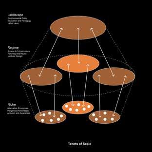
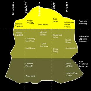
Concepts : Community Economies Iceberg
Space : Community Laundry at LaBorda Housing, Spain
Practice : Mutual aid through Barnraising, Prinzessinengarten, Germany
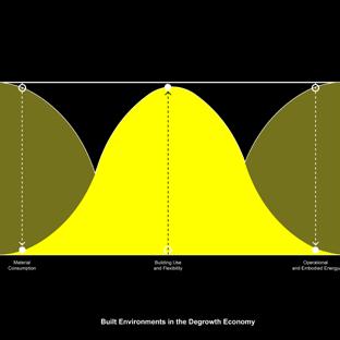
Concepts : Degrowth and the Built Environment
Media and Representation
Immigrant Stories through a Children’s Story Book
Location : Pittsburgh, Pennsylvania
Master of Urban Design; Prototyping Stories
Semester 3, MUD; Carnegie Mellon School of Architecture, Role - Individual Project
Timeline- Aug 2023-Dec 2023
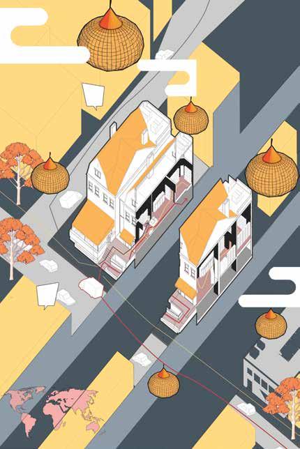
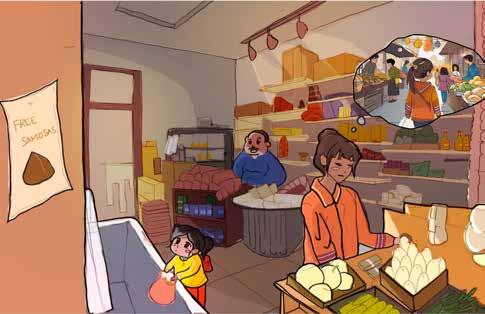
Through ethnographic research, this project aims to tell the story of an Indian grocery store in Oakland, Pittsburgh. The medium used is a children’s story book and the graphics were developed to intertwine fact with fiction.
The axonometric drawing aims to capture the immediate urbanity around the store while also deeply inspecting the many actors that are responsible for its working, including the owner and the workers of the stores. The two vignettes speculate the story of a little girl who is fascinated by the store during her visit with her mother. It captures the interior of the store and also the emotions associated with visit, which were related to the owner’s own story. The project aims to reimagine methods in which architecture and urbanism can be represented.


47
Media and Representation
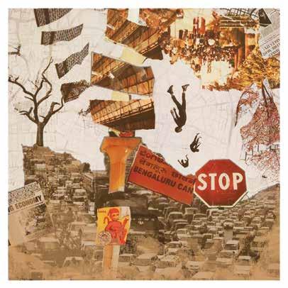
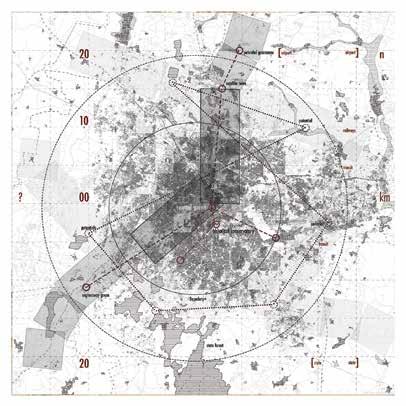
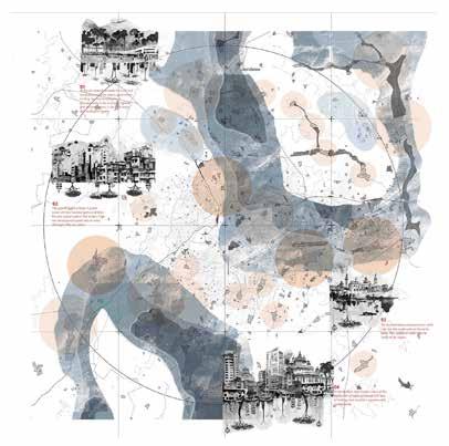
Exploring Mapping Techniques for Bangalore
Location : Bangalore, India
Master of Urban Design; Urban Design Media
Semester 1, MUD; Carnegie Mellon School of Architecture, Role - Individual Project
Timeline- Aug 2022-Dec 2022
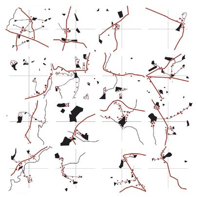
The prompt for this exercise was “analyse your hometown”. Through the semester, the mapping project aims to capture Bangalore in a variety of mediums including analog collage, field conditions and layered mapping, AI and hand sketching. These mapping modes also vary from highly data oriented through GIS to a more psychogeographical, speculative quality.
Data Driven Research | Academic [MUD]
Research projects analysing the bus system and equity of public transport; soil quality and its impact on public health in Pittsburgh, Digging Deeper : Investigating Pittsburgh’s Urban Soilscape
Bus Stop Distribution and Accessibility in Oakland
12
koushik.srinath04@gmail.com ksrinath@andrew.cmu.edu
