
9 minute read
Country walks around Duncow and Newlands

Country walks around Duncow and Newlands Estate
Two gentle low-level walks to introduce the walker to Newlands Estate and the village of Duncow with views across the surrounding area and beyond to Cumbria. The walks can be combined to make one longer walk. Be aware of farm vehicles on the track. Mainly quiet, country roads with a short stretch on a C class road. Although there are no steep inclines both walks involve long slopes (1.5 miles). Two benches have been provided on these walks to allow rest breaks.
Advertisement
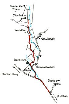
DG1 1TA Grid Ref NX965834 3.4 miles/5.5km
Allow 2 hours
Park in the King George V playing field or near the school. Please keep dogs on leads at all times on this walk. Be aware that newly calved cows, and bulls can be unpredictable and dangerous; do not enter fields where livestock is present. Keep safe and do not climb on unstable, derelict buildings.

Green Walk (Newlands)
1 From the parking place pass the school, and once over the bridge take the next road on the left signposted amongst other places for Newlands and Whitehall. On the left is a small copse of trees, the DK copse, planted by local children in Spring 2015. Head uphill following the Duncow burn to the ruins of the old water mill. See page 46 for further details about the mill, marked on the map as 5.
2 Continuing uphill past Sunnybrae, take the right fork along the public road. At Sunnybrae, to the side of the gable end of the building, you will see “Child of Day in the Womb of Night” by well-known artist Cyril Wilson. He and his wife, fellow artist Jane Fyfe, converted Sunnybrae into their gallery in 1962.
3
The next house on the left is Carrickrigg. Shortly after passing it, take the left fork. About 200 metres along this road, opposite Leap House is the site of the Glencarrick Distillery, a folly and a waterfall. The distillery was founded in 1831 but was only in production for a few years.
4 Follow the road round past Whitehall over Newlands Linn towards Newlands on the left. Bought in 1891 by Walter Duncan, a Glasgow tea merchant, extensions including the addition of a castellated lookout tower to the red sandstone baronial house were completed in 1911. During the Second World War, Newlands House was used as a hospital for Norwegian soldiers who were relocated to Dumfries during the occupation of Norway. Walk straight ahead, through the sandstone gateposts and follow the road round to the right. Continue along this winding road past Longbank. The steepest part of the road is known as Neckbreak. There is a tale of an estate worker who was killed in an accident involving a runaway carriage in this area and it may well be that this is how this area got its name.
5 On the right you will pass Quarrelwood House which was built around 1798 as a Cameronian manse, with an attached octagonal chapel. Subsequently the chapel fell into disrepair but in 1969 was rebuilt to form a private library for the house. Beside the ruined walls there was an ‘efficiently run’ hand laundry. Parcels of clothing arrived each week to be washed, ironed and parcelled up again to be returned to their owners within a few days. A Mrs Seaton who was employed at the laundry worked there for 33 years with only one half day absence from her work. Behind Quarrelwood is the site of another prehistoric fort. If you look across to the left you will see a large oak tree surrounded by a range of grassy knolls. This geological feature, known as terminal moraine, provided a safe area where Covenanters held their meetings. As you follow the road round you can get different views of this meeting place. Look out for the horse watering trough built into the wall. The rough field in front of Quarrelwood was a fairly large township with several cottages and about 70 inhabitants. This township predated Quarrelwood.
6 Continue on down the road to the T junction. In the field on your right there is a 1 metre high burial mound/cairn which would originally been up to 4m high but has been destroyed by Victorian treasure hunters. In the past an old road called the King’s Road ran from Quarrelwood to Dalswinton. Before you turn left at the T junction and walk along the main road to the school, look across the road. Recently excavated prehistoric barrows in this area contained burials from about 1,000 BCE. In the 19th century the first house on your left was the Free Church School. As you look along the main road you will see the primary school where the walk started.
Red Walk (Duncow)
Take the road signposted for Amisfield past the primary school which dates from 1878 and serves the whole parish. The houses on the left are all that remain of Duncow Village. The first house on the left was the village shop. Follow the road over a little bridge and carry straight on this rising, winding road with the Duncow Estate on your right. Further on you will see the ruin of a late 17th century windmill on your left. Until the beginning of the 20th century the now wooded triangle of land on the right is where cattle and sheep could be rested before being taken down the drove road to Amisfield station and then on to Lockerbie market. The windmill stump on the left is some 30ft high and is built of sandstone rubble. There are two doors, one of which has been blocked up. At the road junction, the field to your right is known as The Gallas Moor (the 1855 map shows it as Gallows Moor) and is thought to be the site of the gallows used for public hangings. Take the junction on the left and, if there are no animals in the field or silage crop being grown, go through the first gate on the left if you want to visit the windmill. The building was used in Victorian times for drying sheepskins. In this field and in the field to the right of the road are Neolithic standing stones which line up with the Cursus monument at Gallaberry. Many of these stones are used by farmers as rubbing stones for their cattle. Return to the road. In the field opposite is another standing stone. In the woods is the site of an old plantation called Perie’s Chest or Peerie’s Kist. This name denotes a fairy ring, and It is likely that stones here were part of an ancient stone circle
1
Continue along this road. As the road starts to climb, on your left is the site of an Iron Age fort at Castlehill. If you go through a gate to the left just beyond the two houses you can take a short detour to the site by following the track along the burn and going through the gap in the wall ahead. The site of the fort is the hill on your left. From the earthworks can be seen the sites of the forts at High Townhead, Mullach and others which allowed communication between forts over a vast area from Cumbria to Lanarkshire and probably much further afield. Return to the road and continue up the hill.
2
After about a kilometre, at Knowefoot Place, take the left turn signposted “Footpath to North Riddingwood”. This path takes you towards Auchenrath farm buildings. Bear right here and continue along the path swinging to the left further up the hill to the ruins of North Riddingwood. This part of the walk provides the walker with amazing panoramic views of the Solway and Cumbria. As you walk you will see many rounalls – walled areas of trees which are used to shelter the cattle and sheep in winter. Many of these have been extended to provide larger woodlands.
3
Turn left and head downhill past Carrickrigg. At Sunnybrae, to the side of the gable end 4 of the building, you will see “Child of Day in the Womb of Night” by well-known artist Cyril Wilson. He and his wife, fellow artist Jane Fyfe, converted Sunnybrae into their gallery in 1962.

Slightly further down the road on the right are the ruins of Duncow Mill. See below for information about the mill and a guide to the buildings which are still on the site. Continue down the hill, turning right at the junction and walking over the bridge again and past the old Smiddy to where you began the walk. There was a cottage on the hill behind the Smiddy where it is believed James V spent the night but the stone erected to mark this event disappeared many years ago.
5

Duncow Mill
Apart from grain milling, this was also the site of a cotton mill and blanket factory in the past and provides an interesting insight into the life of the villagers. There were five main mill buildings here in the past and the 1861 map also shows several other buildings. Follow the sign for Mill Cottage and stand on the bridge to get the best view of the ruin on the right at the end of the bridge which was the carding mill for the blanket factory and wool mill. Carding is the process of cleaning, separating and straightening out the wool fibres. It is the last stage in the process which prepares fleece for spinning. In the area you will see teasels growing. These were used to card the fibres until more advanced tools were developed. The ivy covered structure which looks like an enormous tree is actually the chimney. On the wall of the building you can also see the metal ring used to tether horses. Bear right between the gate posts past the mill buildings where you can see the wear marks of the mill wheel on the rear elevation of the building on the left. From here you can see some of the other mill buildings one of which contains the remains of the axle and wheel. Carry on past the building up the hill past the Christmas tree plantation to where the path bears round to the right. There is a small stone building here to the side of which are tanks which were the filtration system for the water supply for Duncow House. Retrace your steps and go up to the mill pond. This is a mainly man made structure built to hold the water used to run the millwheels via a ditch and mill race to the burn. Return to the path by the trees and turn right at the gateposts and head slightly uphill. On the lintel of the building on your right as you walk up the hill is the date 1797 although it is faint and may be covered by ivy. Rejoin the walk.


