3 minute read
Dalswinton Moor


The Dalswinton Moors
A walk on a very quiet country road and tracks from Dalswinton Village.
Advertisement
A circular walk through Pennyland Moor and Shaws Moor, mostly on metalled surfaces. Some short stretches may be muddy. There is one very small shallow ford. DG2 0XU Grid Ref NX934854 Distance 6.5 miles / 10.5km
Allow 3.5 hours
Jun - Oct
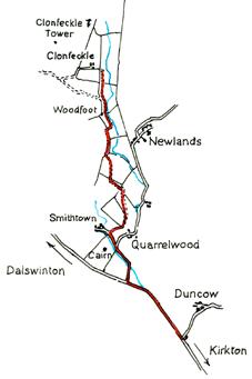
Park in Dalswinton Village. At the north end of the village is a minor road heading uphill between the old school and the school house. Walk up that road until you reach a fork and take the metalled track to the right. Continue walking up the road as it becomes less steep and forks to the left. Continue along the track to a stream. Cross this into Wildcat Glen. At the end of the glen, the track turns right and crosses the stream. The track then forks again. Take the right, uphill fork. Do not go through any gates here. As you reach the the top of the track go through the gate straight ahead but first look back down the glen at the view towards Criffel. As you proceed you will see the Dalswinton windfarm ahead to your right. Before you reach the very top of the track look back once more towards Criffel. In the distance you may be able to see the Cumbrian mountains across the Solway Firth. The track drops down towards the outbuildings of Pennyland farm. The farmhouse no longer exists. Continue along the track. Either go through the farm yard gates or to the left of the barn to rejoin the track which can be seen rising up towards the wind farm. Continue to follow the track across the shallow ford. A wooden fingerpost points the way up the hill path to Shaws. The track, which may be quite muddy, goes a few yards through a pine wood to a gate at the far end. Once you go through the gate, the track bears round to the left up the side of the wood. You will arrive at a gate with another finger post, pointing back towards Pennyland. Straight ahead you can see a low hill with a
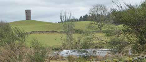
distinctive clump of trees on top. It is known as The Watchman. Continue to follow the track as it bears right downhill. As you drop down towards Shaw’s Farm you may again be able to see the Solway and Cumbria straight ahead. On your left in the distance is the flat top of Burnswark. The hill on your right here is Wardlaw. It was a frequent meeting place for Covenanters. Keep following the windfarm road generally downhill. In half a mile or so you will see Clonfeckle Tower in the field to your left. As you pass the flighting pond there is a gate into this field. If you take a short detour you can follow the clear track to visit the unusual circular tower which was erected in 1810. Continue down the road, going through the double gates and following the road as it bears right. A few yards further on, do not take the road straight ahead through the gate but keep right, soon passing a house on your right and then, a short distance further on as the road winds its way downhill, another on the left. The windfarm road will be on your left as you walk towards the T junction, where you ignore the track to the left and keep right towards Dalswinton Mill. Go left past Dalswinton Mill and follow the road down to the junction with the main road. Cross the road and immediately turn left into the cottages at Douganstyle. Just after you pass the cottages, turn right along the path through the trees. Make your way along this path, passing behind Dalswinton Church until you reach the south end of Dalswinton village. Dalswinton Church is a red painted ‘tin tabernacle’ bought from a catalogue. Many similar churches were shipped out as kits to new settlements in America during the nineteenth century. It is worth taking a detour to admire it.