

URBAN PLANNING PORTFOLIO MACKENZIE EBERHART

ABOUT ME
I am in my fourth year at the University of Cincinnati for a Bachelor in Urban Planning. I have four semesters of professional experience from working at a design center, a city community development department, an aviation consulting firm, and an urban design firm.
I have practice in community development and the non-profit sector, as well as in technical processes like site analysis and site planning. I have interest in landscape architecture, urban revitalization, and sustainable design.
I am a self-disciplined and wellorganized individual who works well in a collaborative setting. My communication and leadership skills allow me to initiate and carry-out difficult tasks. I have a natural drive to produce the best results which demonstrates my commitment.
SKILLS
Adobe Suite
Google Suite
Microsoft Office
ArcGIS Pro
QGIS
SketchUp
Rhino 3D
EDUCATION
University of Cincinnati | Cincinnati, OH College of Design, Art, Architecture, and Planning Class of 2025 | 3.98 GPA Bachelor of Urban Planning
EXPERIENCE
Common Ground Urban Design + Planning | Franklin, TN
January 2024 – April 2024
Urban Design Consultant Co-op| Full-time
Produced street sections from AutoCAD and Photoshop as well as a framework plan for a downtown urban design plan. Developed a design guidelines update document for a town historic district. Contributed data collection and ArcGIS mapping to a transitreadiness study for a local TOD project along with peer engineers, planners, and consultants. Assisted in the initial public engagment stages of the master plan update for a rural town. This included producing table maps and materials to guide a community charrette and design workshop.
Ricondo & Associates | Cincinnati, Ohio
May 2023 – August 2023
Aviation Consultant Co-op| Full-time
Contributed to the inventory and requirements chapters of the master plan update for a major international airport. Presented existing airport conditions as well as a gating and parking analyses to determine site capacities. Produced tables, charts, maps, and exhibits in AutoCAD and SketchUp to be used in official reports. Communicated directly with my client to produce packages of floor plans and lease outline drawings used to bid available leasing spaces.
Toledo Design Collective | Toledo, OH
January 2022 – April 2022
Urban Planning Co-op | Full-time
Constructed comprehensive and action plans for the Englewood and Junction neighborhoods within the city of Toledo. Designed maps, graphics, and brands using Adobe Creative and ArcGIS software to visualize demographic and historical data in the final reports. Researched patterns of the neighborhood target areas and summarized the findings. Performed suitability analyses.
CONTACT
Email | eberhame@mail.uc.edu
Phone | (859) 739-0053
105 Casagrande St. Fort Thomas, KY 41075
https://www.linkedin.com/in/kenzie-eberhart-98abaa200/
2


4 02 TABLE OF CONTENTS 06 05 01 20 SITE DESIGN & PLANNING 22 CURRENT CONDITIONS 23 SITE SUITABILITY 24 DEVELOPMENT PLAN ENGLISH WOODS SITE PLAN 6 HOUSING REPORT AFFORDABILITY STUDY 8 REQUEST FOR PROPOSALS AIRPORT CONCESSIONS 16 STREETSCAPE SECTIONS 18 FRAMEWORK PLAN 19 STREET SECTIONS DOWNTOWN PLAN


5 32 TRAIL DESIGN & PLANNING 34 SYNTHESIS 35 IMPLEMENTATION 36 STRATEGIC PLAN 26 HOUSING ACTION PLAN 28 FRAMEWORK 03 MILL CREEK TRAIL PROJECT JUNCTION 6-BLOCK AREA 07 04 12 IMPLEMENTATION PLAN REGIONAL PLAN 08 10 GATEWAY RENDERING SPRINGFIELD STREETSCAPE
ALTA VALLE CAMONICA AFFORDABILITY STUDY
HOUSING REPORT | FALL 2023 STUDIO
Last fall, I attended Politecnico di Milano through an international exchange taking master’s level courses at the School of Architecture. One of these classes was understanding the various housing and neighborhood issues across the world. The semester-long assignment was a group-effort to identify a unique situation of housing un-affordability, investigate that area, and after careful analysis, provide creative opportunities as potential future guidelines.
“The expensive price to pay to live in a ghost town” is a study aimed at understanding the relationship between depopulation and the housing sphere. The focus area is Alta Valle Camonica, a mountain region in the Italian Alps known for ongoing processes of depopulation. The research method is characterized by two phases: an analysis and a guidelines proposal. The first investigates where depopulation is taking place and deepens related facts and figures concerning demography, movements of people and economy. Then, housing and tourism are explored to understand why the empty house phenomenon is taking place in the valley. The results pointed to a need to attract permanent populations, which became the guidelines proposal objective. Two strategies, backed specific policies, were developed through actions and related case studies to support their feasibility as the report conclusion.
Milan, Italy
6
Visit RFP at SMF Food & Beverage 2023
relationship mountain why attract backed by feasibility level housing analysis,

Administrative division

7
Terrain National Parks PLIS
Hydrography Glacier Roads Railway Buildings Natural Parks
SACRAMENTO INTERNATIONAL AIRPORT CONCESSIONS
REQUEST FOR PROPOSAL | SUMMER 2023 CO-OP
Sacramento County Department of Airports (SCDA) seeks to provide a unique concessions experience. The goal is to “meet customer needs and preferences at different price points, exceed their expectations by surprising them with high-quality food and services, and offer a variety of choices and options.” The RFP visualizes the opportunity spaces and outlines their anticipated concept themes for potential tenants and proposers to choose from.
SCDA was my first co-op client. The team consisted of a senior consultant and director from another office location in addition to myself. I was tasked to complete the AutoCAD work requested by the client. Meetings were initially held to gather expectations and deliverables. Various progress meetings guided the project until the client was satisfied. SCDA’s project strengthened my technical and social skills by entrusting me with this large responsibility.
Sacramento, CA
8
Visit RFP at SMF Food & Beverage 2023


9 INTERNATIONAL CONCOURSE B CONCESSIONS
SPRINGFIELD PIKE STREETSCAPE PLAN
GATEWAY RENDERING | FALL 2022 CO-OP
An intentional gateway between Wyoming and the Village of Woodlawn jurisdictions does not currently exist. Our common goal is to improve the visual character and quality of this shared gateway, encourage redevelopment, soften the transition, and increase connectivity for the corporation line along the Springfield Pike corridor. The focus is on establishing a high-quality streetscape design that creates a welcoming and pedestrian-scale environment.
One major task from my co-op was to write and publish a Request for Proposals for the Springfield Pike plan. The Gateway is one of three focus areas outlined in that proposal. A personal objective of mine was to improve my skills in SketchUp. The gateway rendering was a collaboration between the work I was involved with at the City of Wyoming and intentions I had for myself.
Wyoming, Ohio
10
Visit RFP at Springfield Pike Streetscape Plan


11
SOUTHWEST OHIO REGIONAL PLAN
IMPLEMENTATION PLAN | SPRING 2023 STUDIO
The project investigates underutilized sites, once valuable and now in need of repair in the Greater Cincinnati area. Current development patterns favor blank slates over reclamation, which is not sustainable. The findings point to opportunity areas where alternative thinking can be implemented. The goal is innovative, resilient solutions.
A successful regional approach values micro and macro scales as effective design strategies are critical at both. The plan offers zoomedin example sites & communities within the overall study area, presenting implementation strategies recommended based on analysis and the current best practices. The objective of these site initiatives is to create a chain reaction in development patterns for more sustainable types of development.
Information was collected as a three person team effort for the overall regional plan. View the project here The site specific example was individual work.
Cincinnati, OH
12

13
GROUP PROJECT
OUR PROCESS
After pointing out vacant sites across the region, identifying their current factors and trends, classifying the data collected and studied, recognizing their opportunities and suitability of uses, we developed a regional plan to tackle vacancy as a whole. Our implementation strategies consisted of preservation, recreation, commercial, or residential use. Then each group member designed an approach to proposing each of these strategies through a simplistic site plan.
BELOW: Current conditions and proposals of the site.


14
INDIVIDUAL SITE
PROPOSED PLAN
One of the last lots available for development in the fast-growing neighborhood. Renovating the existing building footprint into a rent-controlled residential complex with a variety of unit types would provide necessary attainable housing in close proximity to more accessible public transportation.
This development pushes the boundaries of traditional social housing to eventually become the catalyst for the city in the longterm. Design elements include a lush green courtyard, thoughtfully surrounded by four main mixed-residential, and located behind a community center that fronts the main through-street. Concepts included green courtyard tree canopy leading into preserved forest area parking located in rear to buffer sound from interstate.


15
CAVE SPRINGS DOWNTOWN PLAN
STREETSCAPE SECTIONS | SPRING 2024 CO-OP
My most recent co-op was at a consulting firm, Common Ground Urban Design + Planning, located in the Nashville area. Due to the small team size, I was able to take on a role with responsility. Based out of Franklin, Tennessee, Common Ground works in numerous cities primarily throughout the south, including some local in the Nashville Area. I had the opportunity to work on various projects ranging from comprehensive plan updates to design guidelines documents, as well as travel to participate in charettes and collaboarte with other planner, engineers, and consultants on a TOD readiness study for the city of Nashville.
My final project for the semester was the Downtown Plan for the City of Cave Springs in Arkansas. I mapped the existing condtions of the study area, designed a framework plan, designed team maps for community engagment events, and measured and designed street section alternatives shown here on the right.
Cave Springs, Arkansas
16
Visit other projects at Common Ground’s
website

17
FRAMEWORK PLAN
WORKSHOP MAP

18 Study Downtown Traditional Traditional Mixed Rural Conservation City 1/4 Mile Main Parkway Roundabouts Major Trails Parks Potential Floodplain
STREET SECTIONS
DOWNTOWN PLAN ELEMENTS
EXISTING SECTIONS


PROPOSED SECTIONS


19 Study Area Downtown Core Traditional Mixed-Use Traditional Residential Mixed Residential Rural Conservation Center Mile Radius Main Street Parkway Roundabouts Major Roads Parks Potential New Parks Floodplain
Main Street at Watershed Midway Avenue
ENGLISH WOODS SITE PLAN
DEVELOPMENT OPPORTUNITY | FALL 2021 STUDIO
English Woods is one of the last neighborhoods within the city of Cincinnati to not be fully developed. This poses a unique opportunity. The objective was to look at the neighborhood’s history, strengths, weaknesses, and abilities then design a feasible plan with implementation phases. The challenge was to increase density, while also finding the balance between developed and preserved land.
Data was taken from the Hamilton County Auditor, Cincinnati Area GIS, as well as personal investigation and studies.
English Woods Neighborhood, Cincinnati, Ohio


20


N 0 0.25 0.125 0.5 mile
CURRENT CONDITIONS
English Woods is a Cincinnati neighborhood located about 5 miles northeast from Downtown. The site is conveniently located next to I-75, making it very accessible by car. The most efficient means of transportation to and from the neighborhood are through private vehicles and the public metro. The Bus Route 49 runs through the neighborhood on Sutter Ave. to serve the residents without private transportation.
Over half of the residents living in English Woods do not have access to a car, therefore they rely on the bus or sidewalks to get to their destinations. Due to the very small commercial base in the surrounding area, amenities are not in close proximity to pedestrians. This can create a sense of isolation for these residents. This map displays the closest amenities and provides the commute time to each from the center of the neighborhood.

Neighborhood Boundaries
22
NETWORK
CONNECTIVITY N 0 1 mile 0.5 English Woods Boundary Streets Bus Routes Bus Stops LEAP Academy Swartz Food Market Millvale Community Center Ethel M. Taylor Academy South Fairmount Playground Hopple Street Neighborhood Center
AMENITIES LEGEND
Exploring Excellence Learning Day Care Center Cincinnati State College Berry Library TRANSPORTATION SYSTEM MAP

SITE SUITABILITY
SLOPE & SOIL
SLOPE
English Woods sits atop a hill at an elevation ranging from 500 to 800 feet above sea level. The slope map displays where the percentage rise is greatest, the perimeter of the neighborhood, and least, in the center. The steeper regions of English Woods are less conducive to development than the flat areas on top of the hill. The slope is a determent to pedestrians.
Soil Type
EcD - 15% to 25% slopes
EdF - 40% to 60% slopes
SwC2 - 8% to 15% slopes
UAEXF - 25% to 60% slopes
UATXD - 12% to 25% slopes
UrUXC - 0% to 12% slopes
Soil types are directly related to slope. Erosion is often more present in steep slopes rather than flat. Generally loam is the most desirable soil for building due to its ability to evenly hold water. Previous development in English Woods has been built on UrUXC soil, which is a course texture for adequate drainage on areas with more than 2 feet of fill. Future development would thrive best on this soil.
23
Value <5% FLAT 6-10% 11-15% SLOPE 16-20%
VERY STEEP
>20%
SOIL COMMUTE TIME 3 minutes 17 minutes 17 minutes 3 minutes 15 minutes 15 minutes 4 minutes 19 minutes 31 minutes 6 minutes 37 minutes 37 minutes 5 minutes 29 minutes 29 minutes 4 minutes 16 minutes 17 minutes 4 minutes 23 minutes 24 minutes 8 minutes 52 minutes 53 minutes
DEVELOPMENT PLAN
FINAL SITE DESIGN
The final objective in the analysis portion of the project was to create a design development plan. This combined the land uses determined in the concept design with the specific site planning metrics including the number of additional buildings, square footage, and parking spaces. The built environment and road structures were carefully visualized for the next steps of implementation to be carried out.


N 0 0.25 0.125 0.5 mile
STREET SECTION


PROGRAMMING
Commercial - 28,131 total sq. ft.
- 8 Single story buildings
1. Retail (160’ x 85’)
2. Retail (75’ x 45’)
3. Office (58’ x 32’)
4. Food (40’ x 20’)
5. Retail l (55’ x 60’)
6. Food (32’ x 25’)
7. Food (40’ x 60’)
8. Gas station (40’ x 60’)
Community Center - 4,800 total sq. ft.
Community Garden - 13,600 total sq. ft.
Park - 40,000 total sq. ft.
Mixed-Use Office - 99,000 total sq. ft.
- 2 Five story buildings (165’ x 60’)
Apartment Buildings - 390,000 total sq. ft.
- 17 Three story buildings (80’ x 60’)
- 3 Four story buildings (120’ x 60’)
- 3 Five story buildings (100’ x 60’)
Multi-Family Homes - 28,700 total sq. ft.
- 7 Two story duplexes (82’ x 25’)
Additional Units - 309 units
Parking - 750 spaces
Conserved Land - 1,877,787 total sq. ft.
25
JUNCTION 6-BLOCK ACTION PLAN
HOUSING INITIATIVE | SPRING 2022 CO-OP
The Junction Neighborhood Master Plan was recently completed in 2018 to determine shared community goals and focus areas. One item called out in this plan was the renovation of existing housing and the development of new housing. As supplementary material, an Action Plan specifically targeting six blocks of the neighborhood was produced. This plan focuses primarily on housing and improving the quality of life for residents through a common vision.
My responsibilities on the project included community engagement, data analysis and presentation, and the rendering and mark-up of models and maps in Photoshop and Illustrator.
Information is derived from the Land Bank, recent study and evaluation of physical conditions, and neighborhood engagement.
Junction Neighborhood, Toledo, Ohio
26
Visit Plan at Junction 6-Block Action Plan


27
FRAMEWORK
OVERVIEW
This Framework is a guide to fulfill the visions that were created by Junction residents and stakeholders for the target area. This section is divided into the following 5 categories of action items. Below is the Framework Timeline.

28
VACANT
HOUSING EDUCATION & RESOURCES 2022-23 year 1 2023-24 year 2 2024-25 year 3 2025 year 4 2026 year 5 2027 year 6 2028-32 year 7-10 Short Term Intermediate Term Long Term
The education category ensures clear communication between residents, neighborhood partners, and stakeholders which helps to guide the other four categories.
The housing category creates opportunities for existing and future homeowners to stay within the neighborhood and improve their quality of life.
The vacant land category ensures sustainable maintenance of properties and blight elimination. An abundance of unoccupied space creates an opportunity for new housing and business development to be built with limited restrictions, which is an incentive for many investors. One strategy for tackling vacant land is identifying lots for long-term objectives like the addition of mixed-use projects to introduce a necessary commercial presence.

Nebraska Avenue was identified as a connector street since it runs from the neighborhood to downtown. The rendering was created to visualize the potential of a live, work, and play environment within the target area. Additionally, by focusing on these vacant lots along busy streets, the through traffic would benefit business owners with more customers.
29
VACANT LAND INFRASTRUCTURE & CONNECTIVITY
PARKS
Parks within the Junction neighborhood act as anchors for the community. Gunkel and Savage Parks border the east and west sides of the target area. There is an opportunity to use the traffic they generate to attract local business and investment. However, improved maintenance and programming are required to enhance usability. There is a lack of safety measures taken, especially to enforce crosswalks, which pose a threat to children using these amenities.


Renovate worn fields and equipment
Expand shelters, bleacher seating, and splash pad
Pedestrian only pathways
Pedestrian and vehicle entrance
New pathway
30 VACANT HOUSING EDUCATION & RESOURCES
GUNCKEL PARK
SAVAGE PARK
The infrastructure and connectivity category seeks to increase walkability and the flow of circulation to promote a sense of safety for all residents. Two major intersections were identified as opportunity sites and renderings were created to visualize the recommendation of the following improvements: sidewalk and pavement replacement, installation of crosswalk and respective signage, installation of street lighting, planting of trees in open spaces and along the street, and infill housing on vacant lots.


31 VACANT LAND INFRASTRUCTURE & CONNECTIVITY PARKS
NEBRASKA AVENUE & CITY PARK AVENUE
NEBRASKA AVENUE & COLLINGWOOD BOULEVARD
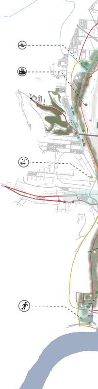
MILL CREEK ACCESS PLAN
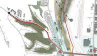
STRATEGIC PLAN | SUMMER 2022 STUDIO
The Mill Creek Alliance is leading an effort to expose its potential to be an ecological asset for the city of Cincinnati. The Mill Creek action plan envisions bridging the communities together through creek connections and trails to strengthen environmental and economic sustainability through the city.
Project criterion included a vision for the community, guiding principles, goals, and strategic plan based on access, equity, ecology and identity in the focus area. Requirements were a strategic plan, strategies synthesis, and an implementation plan.
Information was collected as a three person team effort from various case studies, Cincinnati Area GIS, Census data, Mill Creek Alliance reports, and historical references.
Cincinnati, Ohio
PROPOSED PARK

32
SYNTHESIS BACKGROUND
RECREATION CENTER

DOWNTOWN
33
STRATEGIC PLAN IMPLEMENTATION
SMALE PARK
SYNTHESIS STRATEGIES
Create a distinctive asset by bridging communities together through creek connections that strengthen the environmental and economic sustainability of Cincinnati’s west side.


34
Bridge Lower Price Hill to Downtown and the waterfront by pedestrian trails along 8th Street.
Bridge South Cumminsville to future development in Camp Washington through recreational creek trails.
SYNTHESIS
IMPLEMENTATION
PROJECT 1 - SITE PLAN
The group detailed the following three project approaches, one to align with each of the bridge concepts & strategies. My individual project was the recreational park located in Lower Price Hill

PROJECT 1 - PHASING
1. Acquire Grant Funding
• Parks and Recreation Department annual improvements budget
• Public grants from U.S. EPA,
• Private grants from Greater Cincinnati Foundation and Keep Cincinnati Beautiful
2. Demolish Infrastructure
• Clear and level existing, skate park, tennis court, basketball court, and shelter
3 months - 9 months
3. Construct Bioswale Splash Pads
• Dig storage cisterns and retention basins
• Install connecting piping for drainage system
• Construct splash pads above fountain plumbing.
35
N 0 200 ft 100 +/- 12 months +/- 1 month
IMPLEMENTATION
STRATEGIC PLAN
RECONNECTING OPPORTUNITIES TO AN URBAN CORRIDOR
Cincinnati’s Westside neighborhoods have the potential to be thriving community hubs again. However, the city must commit time, energy, and funding into the Mill Creek area in order to see this vision through and improve the quality of life for residents. This initiative of strengthening east-west connections can begin with the smallest of actions. The guiding objectives and strategies represent the path through which this target is achieved.

36
RECREATIONAL PARK

Opportunity Areas
Check Points
Model Architecture
Storm Water Pond
New Water Quality Testing
Water Quality Testing
Bioswale or Rain Garden
Bridge
Mill Creek
Existing Trail
New Connection
Bike Trail

Creek Recreation
Creek Trails
Rain Gardens
Recreational Park
Industrial Park
Bioswales
37
STRATEGIC
LINEAR PARK
PLAN

Email | eberhame@mail.uc.edu Phone | (859) 739-0053