Lakefront Barriers
We aimed to restore St. Clair –Superior and Hough’s historic lakefront access.
Capturing the future opportunity of CHEERS (Cleveland Harbor Eastern Embayment Resilience Strategy) program

A Centerpiece for the Necklace
Taking inspiration from the emerald necklace in Cleveland, we sought to integrate into the Cleveland’s future lakefront infrastructure.
Young and Old
Understanding co-benefits of interage socializing, we sought to integrate and benefit Horizon Academy
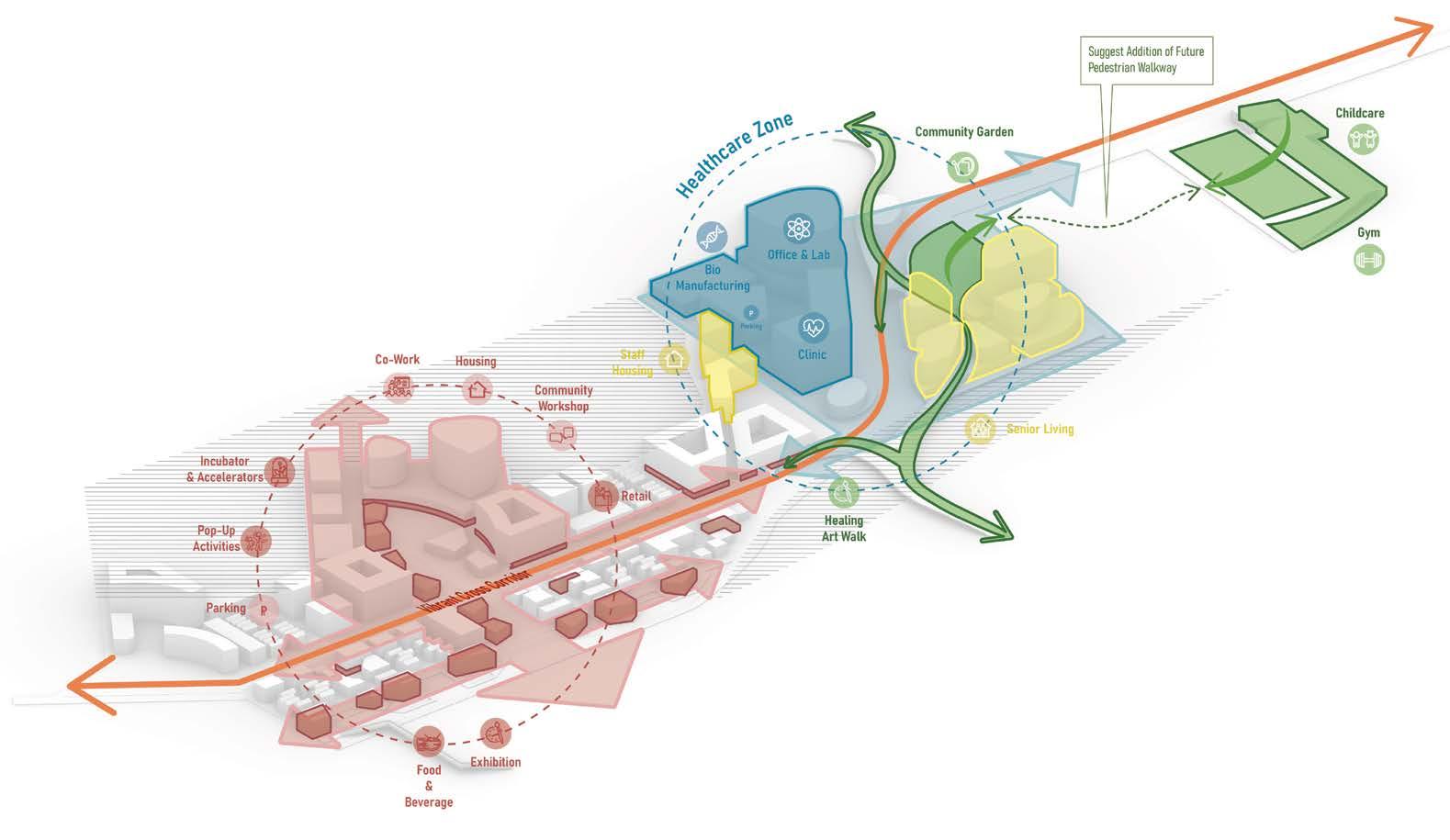
A DAY IN LIFE - ROUTE OF PROGRAMS - Inclusive for All, from Empty-nester to Startup Co-founder


LANDSCAPE STRATEGY - A Green Spline & A Green Landbridge


PHASE I (JAN 2026 - JUNE 2030)
Building a Market


PHASE II (JAN 2029 - JUNE 2033)
Creating a Destination


PHASE III (JULY 2033 - DEC 2036)
Leveraging the Location


On the “Erie Connect” To “CHEERS” Lake Erie Waterfront


02 Massport Going Crazy
01 Massport Going Crazy
Type: Urban Design
Type:
Elements of Urban Design Ex.1 , Harvard GSD
a Rational Plan for Non-government Lead Urban Design
a Rational Plan for Non-government Lead Urban Design
Instructors: Dana McKinney White, Peter Rowe, Michael Manfredi
Instructors: Dana McKinney White, Peter Rowe, Michael Manfredi
Collaboration with Mark Philip
Collaboration with Mark Philip South Boston is rapidly emerging as the hub of Boston – on its west is Downtown Boston bustling with various business activities, and on its east is the great port that at the epicenter of global trade. Massport is the largest landowner in South Boston. It faces the imperative of optimizing its assets to bring social and economic benefits to the area, given its dual roles as a public authority and a business owner. The design considers the perspectives of both the South Boston community and Massport. It aims to build connectivity and shape the South Boston waterfront to be a global destination, continuing the established “Massport” Model. The design is divided into three phases, building a green spine that connects South Boston with the Seaport waterfront by extending the Thomas J. Butler Memorial Park to link with Fort Independence and D Street. An estimated 6M sqft of public green land will be built and accessible to the community, a newly built 2.9 miles coastal line will be restored with a soft edge and a resiliency strategy for floods.
$1.7B, with each phase rolled out over a four-year period. Leveraging Massport’s strong balance sheet and access to capital, this plan offers Massport control over refinancing and capital return. It will stimulate economic development and cultivate a more dynamic and resilient community in South Boston.

Resilience
A more integrated South Boston Waterfront

Connectivity
Neighborhood Intergration Transform the original hard shorelines into marshland to tackle Sea Level Rise (SLR) flood, with boardwalks that can absorb inundation grant public access to the waterfront.


ALONG
THE GREEN
SPLINE
| AFFORDABLE HOUSING & MIXED INCOME HOUSING


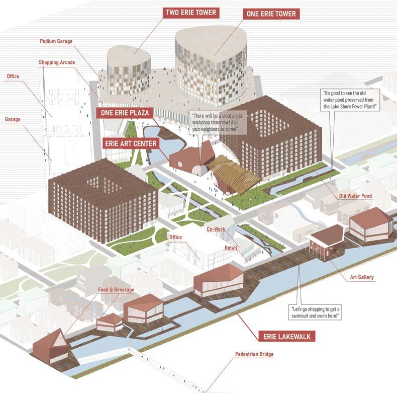
CENTRAL AXIS MIXED-USE CONVERTABLE COMPLEX


PHASE 3 SCENERIO - Waterfront Connected to the Convention Center

Convertable Program Types (Phase 3 - Flexible Core & Shell Structure) (fit out based on market needs - office, lab, housing)


PHASE 1
Newly constructed levee to protect the shoreline.


PHASE 2
A sedimentary wetland and tidal pond was formed and protected the upland area.

3
Housing units were constructed on the upland area, and the newly formed wetland took the place of the original shoreline.


Principal:Yan Meng
Dong, Ken Shukwan Tung


Qianhai Garden Neighborood Renovation Plan - Vertical & Mechanical Parking Research & Design
Neighborhood Revitalizing framework & Vertical Parking Studies
The Qianhai Garden Renovation is an experimental project located in Shenzhen, originally developed in the 1980s. At the time of its construction, the rapid increase in China's vehicle ownership was not taken into consideration, resulting in the community's public spaces being overwhelmed by parking needs. This project innovatively integrates multifunctional, vertical
solutions within the community, seamlessly blending with the existing architecture. By addressing the emerging parking demands, it also expands the community's usable activity spaces.
Contribution: Vertical Parking Research, Developing & Testing Parking Prototype, Assist with Architectural Schemetic Design, Rendering The Qianhai Garden Renovation is an experimental project located in Shenzhen, originally developed in the 1980s. At the time of its construction, the rapid increase in China's vehicle ownership was not taken into consideration, resulting in the community's public spaces being overwhelmed by parking needs. This project innovatively integrates multifunctional, vertical parking solutions within the community, seamlessly blending with the existing architecture. By addressing the emerging parking demands, it also expands the community's usable activity spaces.
Project: 'Qianhai Garden' neighborhood renovation
Team: Ting Wen, Qinxue Wang, Shiyao Yu, Wenhan Dong, Ken Tung
Contribution:
Developing


SCORE | Assessing the Ecological Suitability of Elephant Habitats Under Natural and Human-Caused Factors.


SUITABILITY TRANSFER CORRIDOR SLICE MODEL | Calculate the potential elephant migration corridor by estimating the cost distance of the Habitat Suitability Model ECOLOGICAL SENSITIVITY


potential elephant migration corridor by estimating the cost distance of the Habitat Suitability Model.


Calculate the potential elephant migration corridor by estimating the cost distance of the Habitat Suitability Model.
Methodology: Calculate cost distance of the migration