
Resume

Keerti Rath
keertirath297@gmail.com +19799697905, +918917310743 www.linkedin.com/in/keerti-rath
SKILLS
• ArcGIS Pro
• PTV VISSIM
• Autodesk Infra Works
• MS Office
• Adobe Creative Suite
• AutoCAD
• SketchUp
• Community engagement
• Data Analysis
• Design and Visualization
• Project coordination
EDUCATION
2022-2024 Master’s in Urban Planning Texas A&M University
• Certificate in Transportation Planning and Policy
• Developed a comprehensive transportation plan for the City of Columbus, TX, focusing on improving connectivity and mobility for residents.
• Created a strategic walkability and biking project plan for the City of Jefferson to enhance pedestrian and cyclist safety and accessibility.
• Designed a microtransit service model for College Station to improve first mile-last mile connectivity, enhancing overall public transportation efficiency.
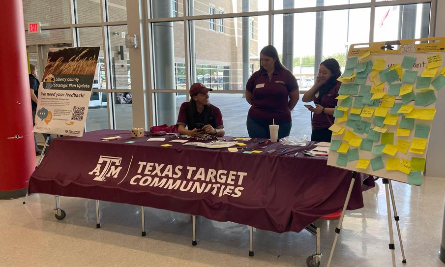
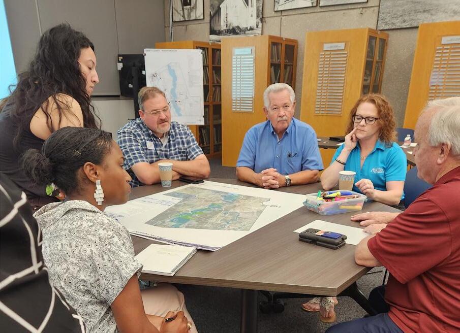
• Collaborated with Texas Target Communities and Liberty County to update the 2016-2036 Liberty County Strategic Plan, focusing on sustainable development and community resilience.
• Developed a comprehensive plan for the City of Jefferson, addressing urban growth, infrastructure development, and community services enhancement.
2017-2022 Bachelor’s in Architecture KIIT University, India
• Architectural and Heritage Study of Mukteshswar Temple Complex, India (Council Of Architecture Heritage Award)
• Historic Preservation and Community Development Design of Maniabandha Craft Village, Odisha, India – Annual Design Competition
• Post-Pandemic Public Spaces – Annual Design Competition
• Sundarbans Disaster Resilient Housing Development for Small Communities
WORK EXPERIENCE
Oct 2023 –Present
Program Assistant ENDEAVR Institute, USA
• Conducted research, collected data, and identified over 20 stops and access points for first-mile/last-mile services.
• Processed and analyzed traffic data to support traffic studies, inform project decisions, and improve service efficiency.
• Summarized and reported traffic-related studies and findings.
Apr 2023 –Present
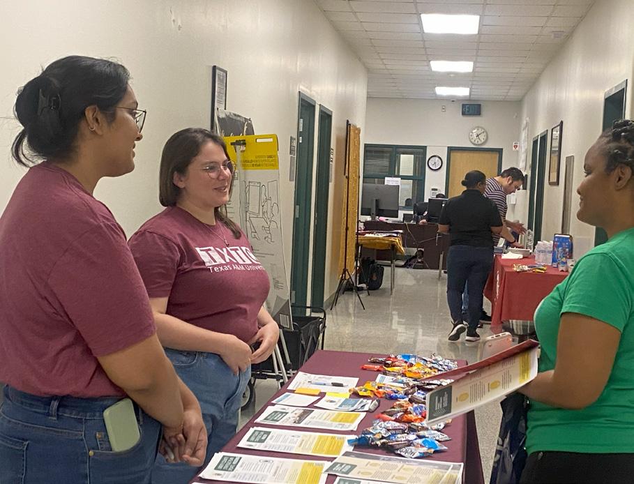
Urban Planning Intern Texas Target Communities, USA
• Facilitated community engagement and outreach programs for Cities and Counties reaching over 300 community members.
• Utilized ArcGIS Pro to develop and visualize over 20 Land Use, and Transportation Maps.
• Computed comprehensive demographic and spatial analysis using ArcGIS Pro.
• Illustrated and designed the City of Jefferson Comprehensive Plan using Adobe Creative
Jun 2023 –Dec 2023
Graduate Assistant
Texas A&M Department of Campus Planning, Construction, and Design
• Coordinated fieldwork at over 10 project sites to assess and analyze campus layouts.
• Collaborated with architects, engineers, and project managers to coordinate design efforts and site management.
• Created designs for landscaping and wayfinding projects enhancing campus aesthetics and functionality.
PROJECTS
Jan 2024May 2024
Transportation Plan
City of Columbus, TX
Structured transportation analysis and developed strategies for improving traffic flow, public transit, and mobility. Corresponded with +10 core committee members to gather input and feedback on proposed transportation solutions.
Jan 2024May 2024
Walking and Biking Plan
City of Jefferson, TX
Designed a plan to enhance pedestrian and cyclist infrastructure in Jefferson City. Analyzed current conditions and proposed safety and accessibility enhancements, covering 15 miles of city routes.
Apr 2023May 2024 APA Legacy Project 2023 Development of Washington Coles Neighborhood Corpus Christi, TX
Devised revitalization strategies for the Washington Coles neighborhood. Focusing on historical preservation and community engagement to create a sustainable development plan.
Apr 2023May 2024
Oct 2023Dec 2023
Comprehensive Plan 2044
City of Jefferson, TX
Illustrated an urban development strategy prioritizing nature, transportation, and land use; engaged with 70+ stakeholders to balance economic, environmental, and social considerations. Assist in updating the strategic plan to reflect current priorities and future goals. Interpreted data and facilitated +10 outreach programs to inform the plan’s recommendations.
Strategic Plan Update
Liberty County, TX
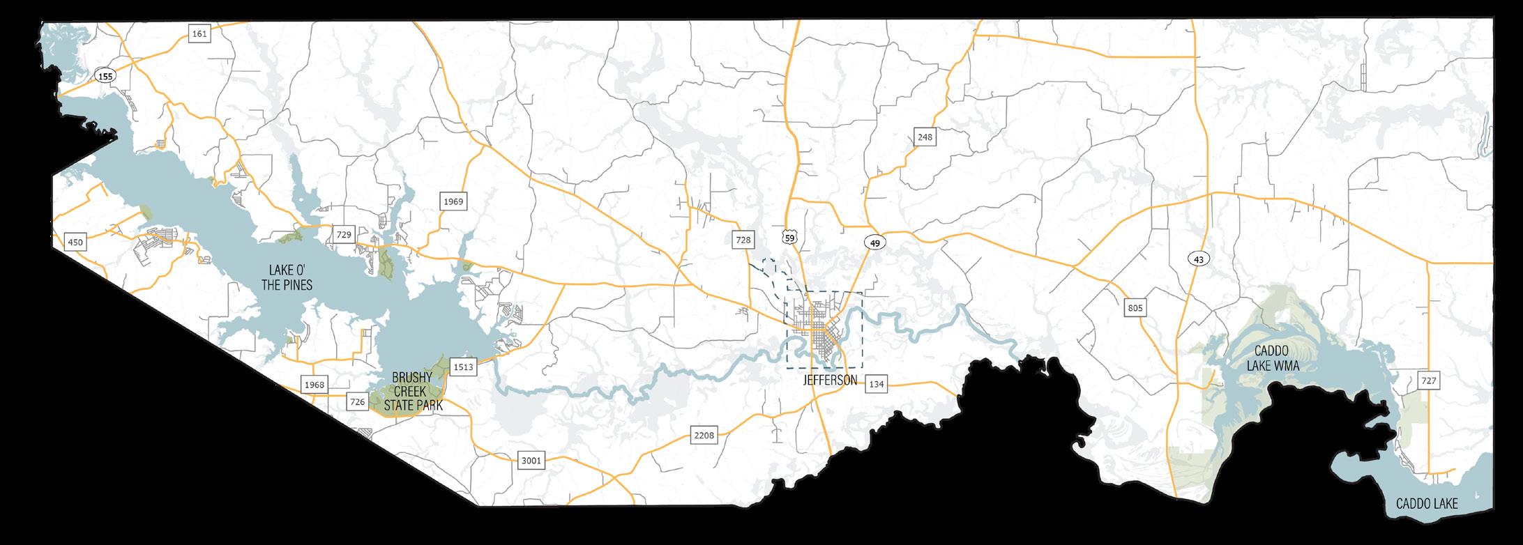
Comprehensive Plan - City Of Jefferson, TX
■ Project Information
Type: Professional Work
Location: Jefferson, Texas
Client: City of Jefferson, Texas
Project Scope: Initiates key projects promoting health, environment, community spaces, economic growth, and safety within 20 years.
■ Objectives
• Promote health & environment: Community gardens, composting pilot, native plant study for parks.
• Enhance community spaces: Parks board, design standards, historic preservation grants.
• Foster growth & well-being: Targeted business incentives, youth skills training, telemedicine.
• Increase safety & access: Fire risk management, public transit awareness, youth food insecurity programs.
■ Background
The Jefferson Comprehensive Plan 2044 serves as a roadmap for the city’s future. Recognizing the need to prioritize resident well-being, environmental sustainability, and economic prosperity, the plan outlines a vision for Jefferson’s development over the next two decades. This project directly addresses this vision by initiating key projects within four focus areas: health & environment, community spaces, growth & well-being, and safety & accessibility. By implementing these targeted initiatives, the project aims to translate the Comprehensive Plan’s goals into tangible improvements for Jefferson residents and businesses.
Key objectives include:
• Community Health and Involvement: Promote outdoor fitness programs and community gardens, and establish a “Friends of the Park” volunteer program.
• Emergency Management and Flood Mitigation: Update the County Hazard Mitigation Plan and strengthen building codes and permitting for flood-prone areas.
• Parks and Natural Spaces: Establish a Parks Board, develop a parks master plan, and implement a parkland dedication ordinance for new developments.
• Historical Preservation: Safeguard historical districts and structures, collaborate with historical societies, and establish a Historic Review Board.
• Economic Growth: Enhance employment, job creation, and support tourism, and implement workforce development programs.
• Health and Wellness: Expand healthcare services, telemedicine, and attract health professionals, and create wellness programs for aging-in-place.
• Youth Recreation: Develop programs for sports, arts, and afterschool activities.
• Public Safety: Enhance fire risk management and support police and firefighter services.
• Community Centers: Support Marion County Community Center and Jefferson Convention and Visitor Center.
• Transit Accessibility: Improve awareness and utilization of the GOBus service.
■ Nature
• Community Health and Involvement
Promote outdoor fitness programs and community gardens.
Establish a “Friends of the Park” volunteer program.
• Environmental Conservation Initiatives
Use native plants, create composting programs, and implement rainwater harvesting.
Establish tree planting and gardening programs focused on native species.
• Emergency Management and Flood Mitigation
Update the County Hazard Mitigation Plan and participate in the National Flood Insurance Program.
Adopt stronger building codes and implement a permitting process for flood-prone areas.
• Proactive Environmental Cleanup
Schedule regular cleanups for creeks and water bodies.
Develop an insect and pest prevention plan.
• Parks and Natural Spaces
Establish a Parks Board and include parks in the city budget.
Develop a parks master plan and adopt design standards.
Implement a parkland dedication ordinance for new residential developments.
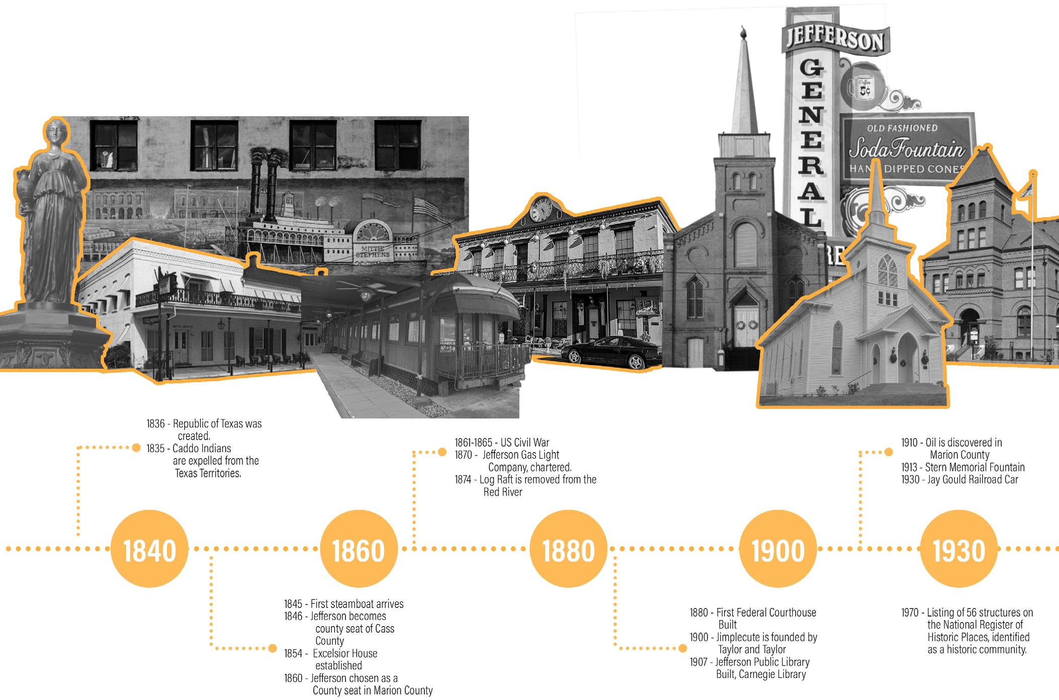
• Historical Landmarks and Community Pride: Jefferson is home to many historic landmarks and museums.
The community is committed to preserving its history, architecture, and cultural heritage.
• Early and Historic Native Americans
Multiple native groups, including the Osage and Caddo tribes, lived in the region.
The area was an important farming and hunting ground before being settled by Europeans.
• Historic and Cultural Assets:
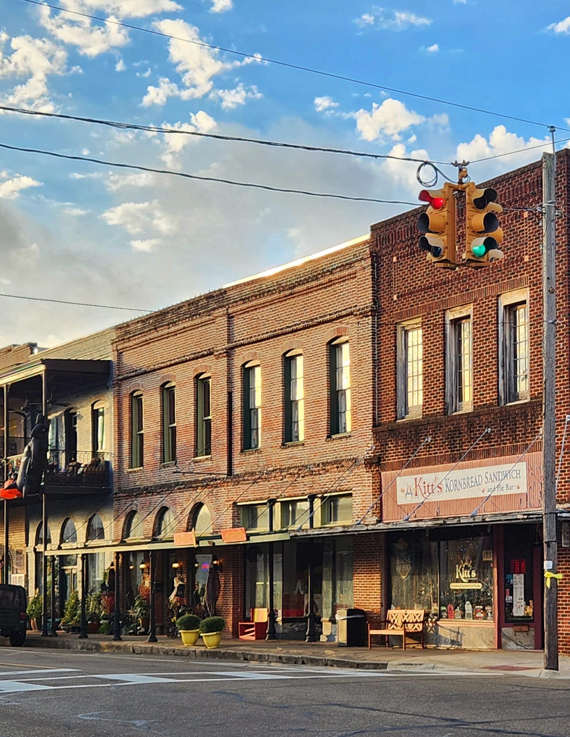
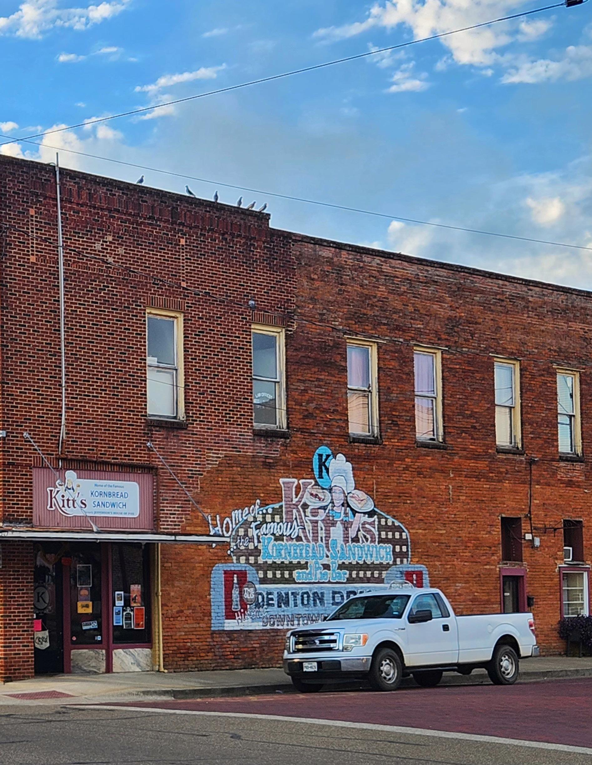
Jefferson has 70 sites listed on Texas State Historic Sites and 18 on the National Register of Historic Places.
Museums in Jefferson cover a variety of topics, contributing to historical tourism.
Significant Native American sites are in the area, requiring special consideration for preservation.
• Goals and Action Items:
Strengthen regulatory measures to safeguard historical districts and structures. Establish design guidelines for neighborhood character and a Historic Review Board.
Collaborate with historical societies and provide resources for preservation.
■ Economy
• Economic Growth:
Employment Trends: From 2008 to 2021, total employment in Marion County increased, with significant growth in Educational Services and Health Care.
Job Creation: Net increase in job creation rates from 2019 to 2021.
• Tourism:
Impact: Significant local travel-related spending, with fluctuations due to economic events (2008 Recession, COVID-19).
Employment: Decline in tourism industry employment post-pandemic.
Accommodations: Jefferson has numerous hotels, bed and breakfasts, vacation rentals, and RV parks.
• Workforce Development:
Education and Training: Need for more training and educational opportunities for youth and recent graduates.
Public Feedback: Desire for job diversification, better education, more restaurants, and improved wages.
■ Multigenerational Community
• Promoting Health and Wellness:
Expand healthcare services, establish telemedicine, and attract health professionals. Create wellness programs and resources for aging-in-place.
• Youth Recreation:
Various programs for youth development, sports, arts, and afterschool activities.
• Public Safety:
Six full-time and three reserve police officers; 24 volunteer firefighters.
Improved fire risk management and public safety needed.
• Youth Food Access:
High child food insecurity; free meals provided by Jefferson ISD.
• Community Centers:
Marion County Community Center and Jefferson Convention and Visitor Center are key hubs.
• Transit Accessibility: GOBus service exists but needs better awareness and utilization.
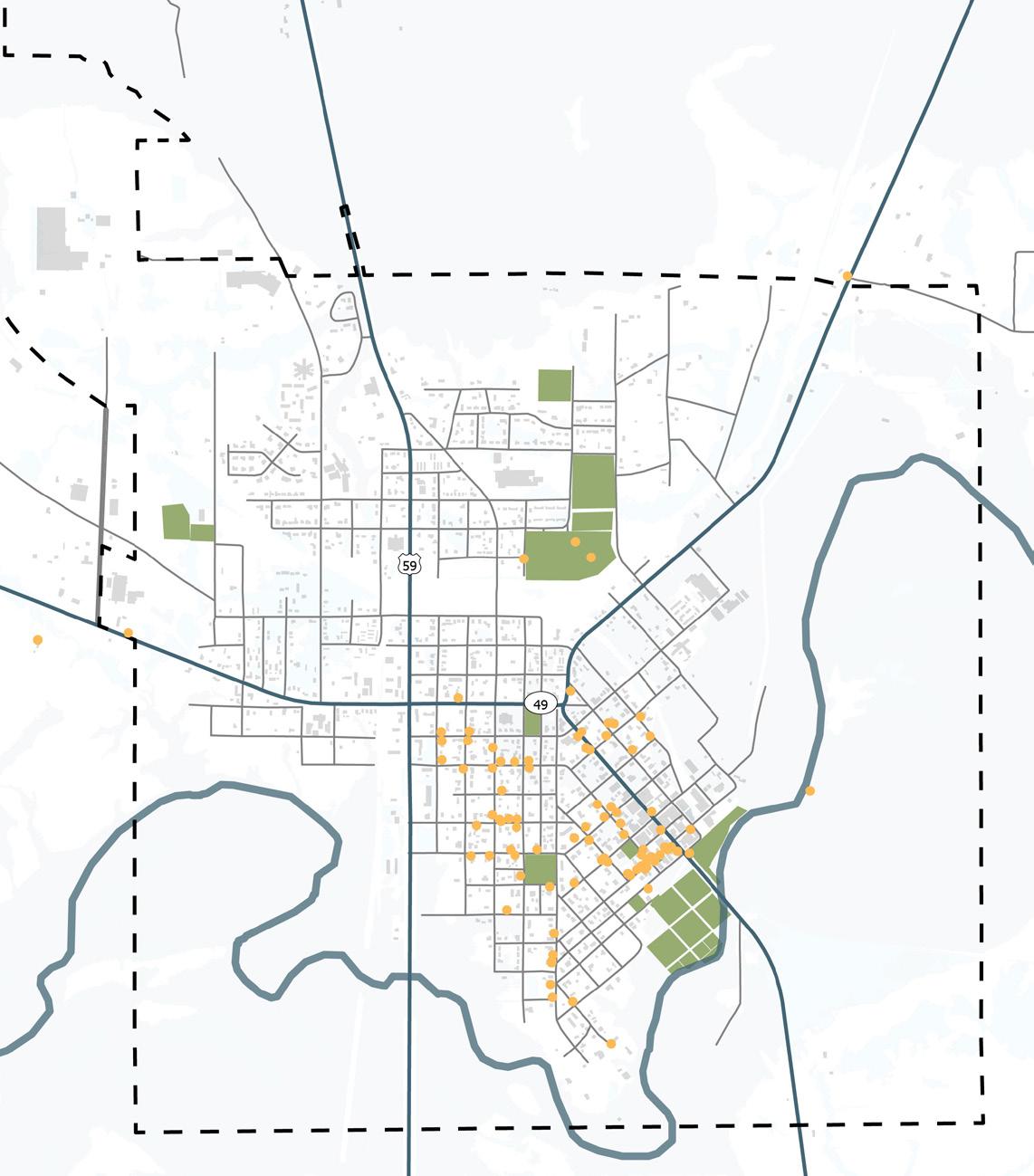
Walking and Biking Plan - City Of Jefferson, TX
■ Project Information
Type: Master’s Dissertation
Location: Jefferson, Texas
Client: City of Jefferson, Texas
Project Scope: Development and enhancement of walkability and biking infrastructure, including recommendations for pedestrian and bicyclist facilities, traffic calming measures, and wayfinding systems.
■ Background
■ Objectives
• Promote active transportation to improve public health and reduce traffic congestion.
• Implement “complete streets” concepts to address all users and abilities.
• Develop and enhance pedestrian and bicyclist infrastructure, including sidewalks, crosswalks, and street lighting.
• Implement traffic calming measures and wayfinding systems.
• Prioritize sidewalk development and ensure accessibility for all user groups.
Jefferson, Texas, with its population of 2,240 as of 2021, is renowned for its rich history and heritage tourism. Once a bustling riverport in the 19th century, the city now stands as a serene historic town with well-preserved antebellum architecture, cobblestone streets, and landmarks like the Jefferson Carnegie Library and Jefferson Historical Museum. Despite its cultural allure, Jefferson faces challenges in transportation and infrastructure. Issues include poor road conditions, high car dependency, and inadequate pedestrian and bicycle infrastructure, contributing to traffic congestion and safety concerns. To address these challenges, a comprehensive transportation plan is proposed.
Key objectives include:
• Enhancing Connectivity: Improving pedestrian and bicyclist infrastructure to better connect neighborhoods, commercial areas, and tourist spots, reducing reliance on cars.
• Promoting Sustainable Transportation: Encouraging walking and biking to reduce carbon emissions and promote environmental sustainability.
• Improving Public Health: Creating safe, accessible pathways to encourage physical activity among residents and visitors.
• Boosting Local Economy: Attracting tourists and supporting local businesses by enhancing walkability and biking infrastructure.
• Increasing Safety: Implementing measures like traffic calming, safe crosswalks, and adequate lighting to improve safety for all users.
The plan emphasizes community engagement, data-driven decision-making, inclusive design, clear wayfinding systems, and sidewalk development. These efforts aim to transform Jefferson into a more walkable, bike-friendly city that enhances the quality of life for all.
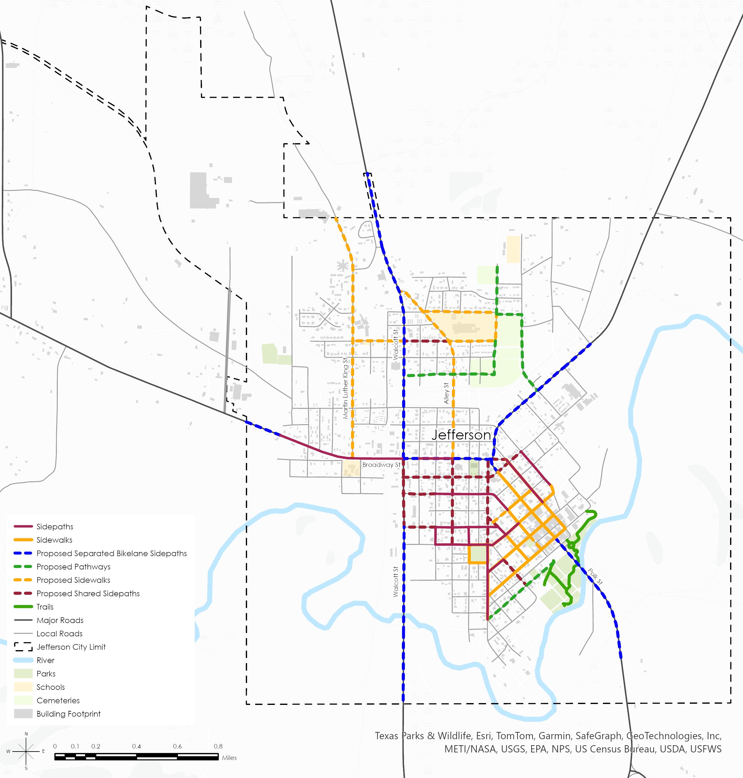
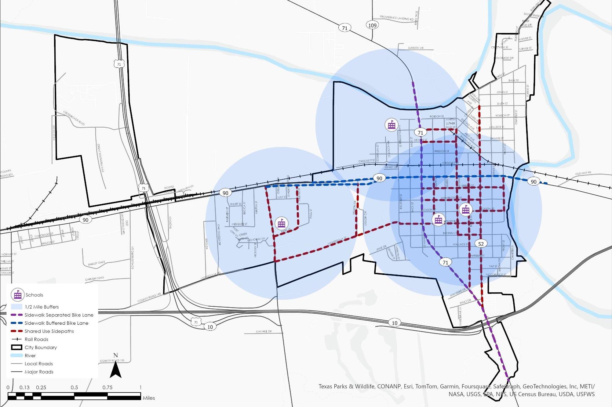
■ Recommendations
GOAL – IMPROVING MULTI-MODAL ACCESS AND SAFETY IN THE CITY
• Increase Network Coverage:
Build sidewalks and shared-use paths along major roads, prioritizing based on a sidewalk prioritization table.
• Enhance User Experience:
Improve existing sidewalks, bike lanes, and crosswalks to meet accessibility standards and ensure comfort for all users. Implement traffic calming measures and collaborate with schools for a Safe Routes to School plan.
• Improve Connectivity:
Enhance connectivity between neighborhoods and destinations by improving park trails, prioritizing connections, and collaborating with parks departments for funding. Implement signage and wayfinding systems, improve safety measures, and invest in multi-use paths and bike lanes.
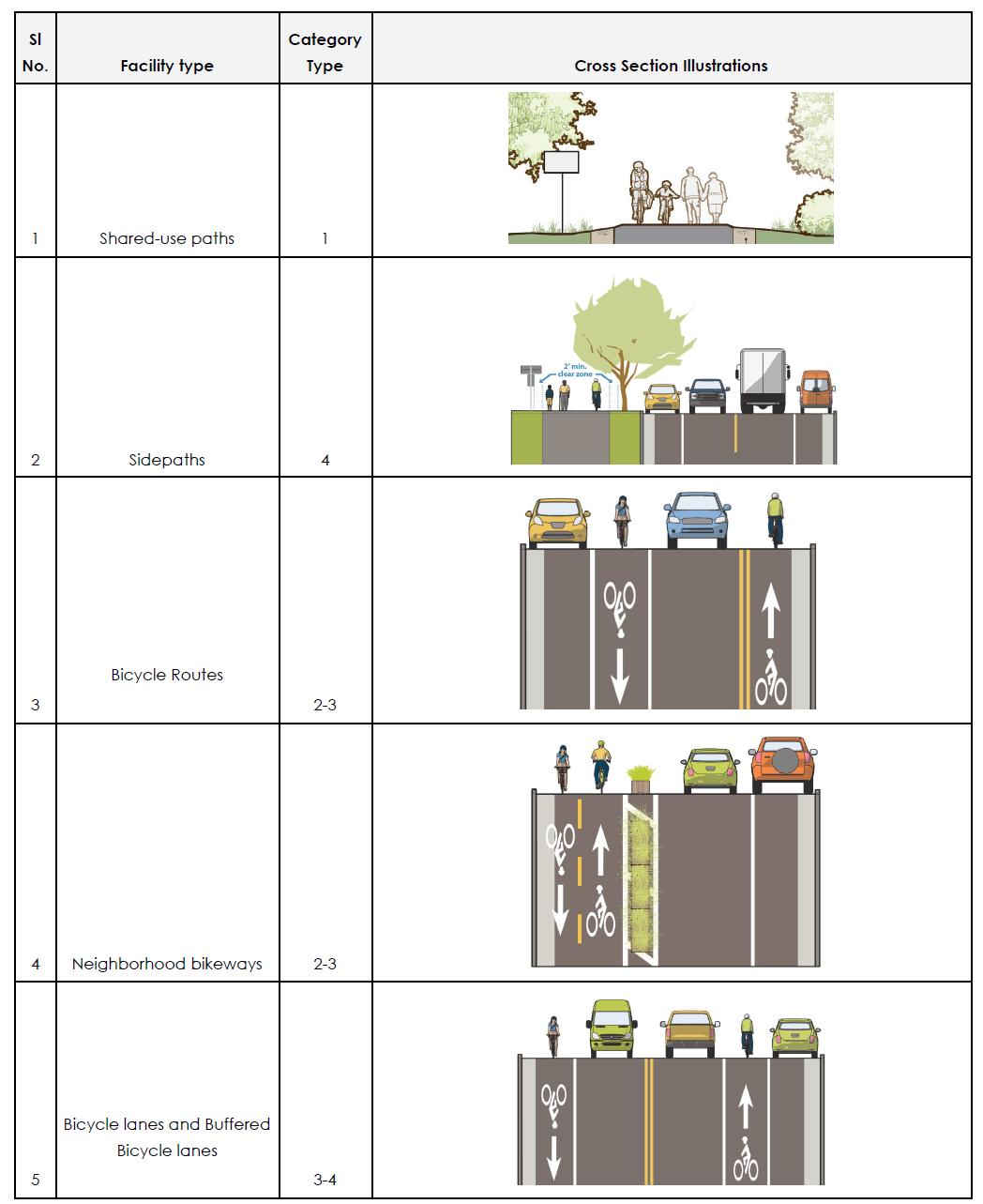
DESIGN TOOL KIT FOR FACILITIES
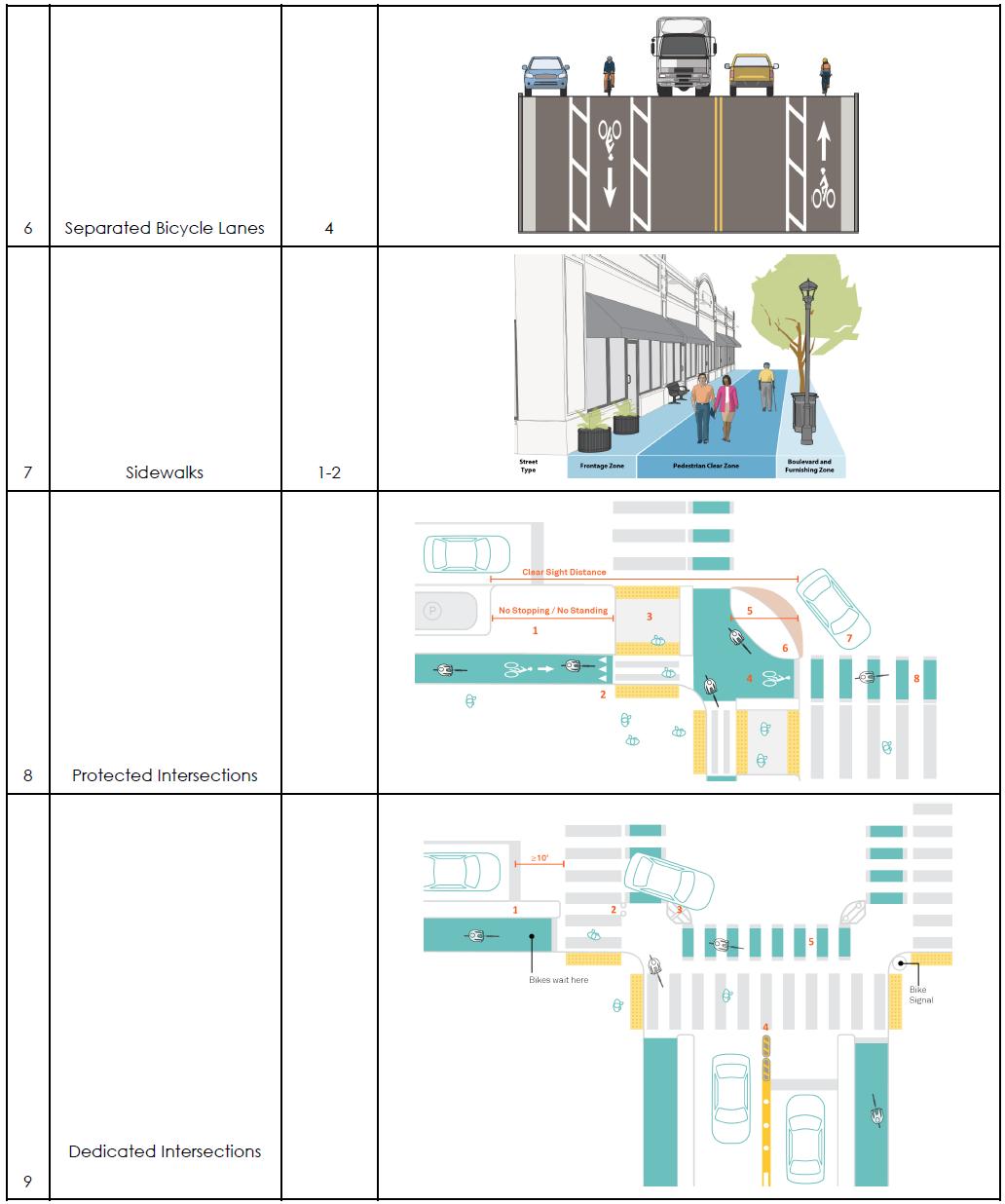
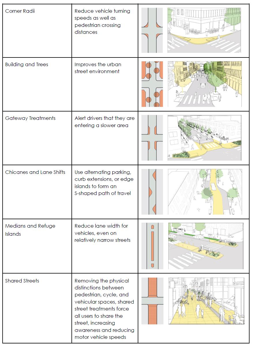
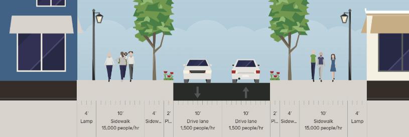
This street design guide goes beyond just prioritizing pedestrian safety and accessibility. It offers a comprehensive approach that respects the city’s unique character and history. By incorporating Jeff Speck’s walkable city principles, this provides practical recommendations for sidewalks, bike lanes, and intersections.
• Shared-use paths: Designed for recreation and commuting, with a minimum width of 10-12 feet.
• Sidewalks: Standard widths vary between 4 and 6 feet in residential areas, with larger widths along major roads and schools.
• Bicycle facilities: Include options like designated routes, neighborhood bikeways, bicycle lanes, and separated lanes.
• Intersections: Improvements include protected intersections, dedicated intersections, and minor crosswalks with traffic calming features.
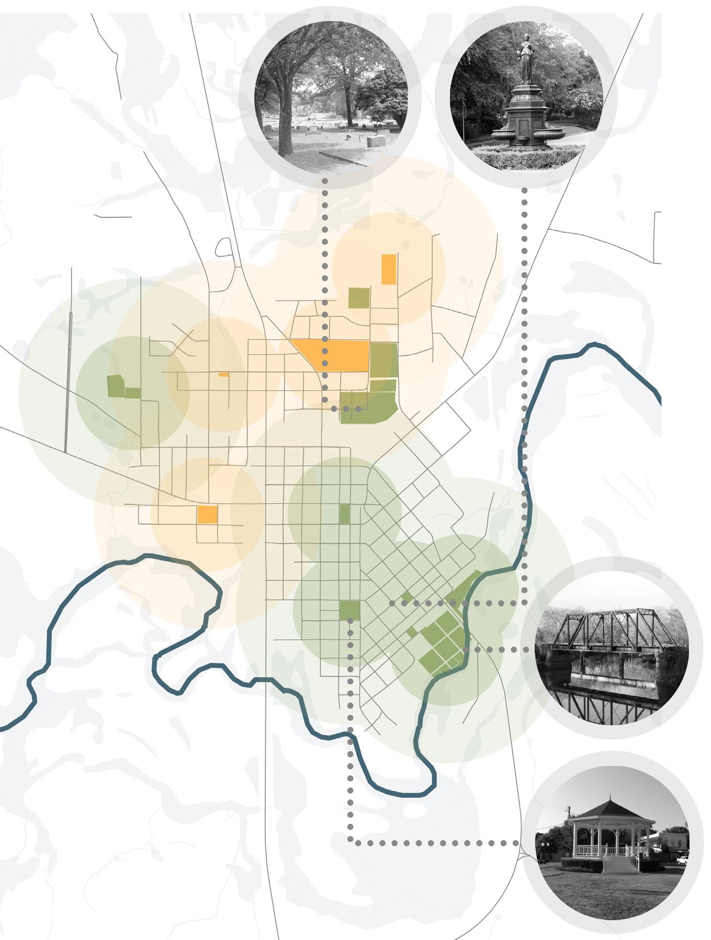
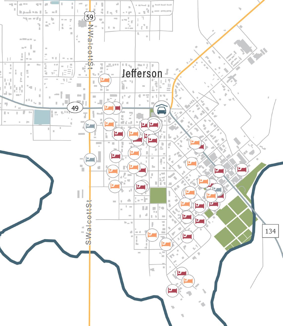
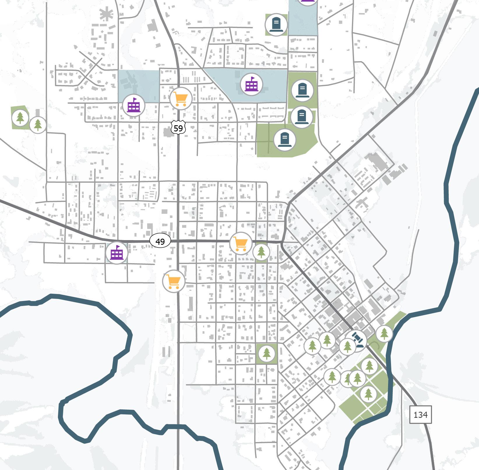
SIDEWALK PRIORITIZATION
• Method: Utilized data from site visits, community feedback, Google Maps Street View, and geographical information system software.
• Criteria: Scored each sidewalk segment based on various factors to prioritize improvements.
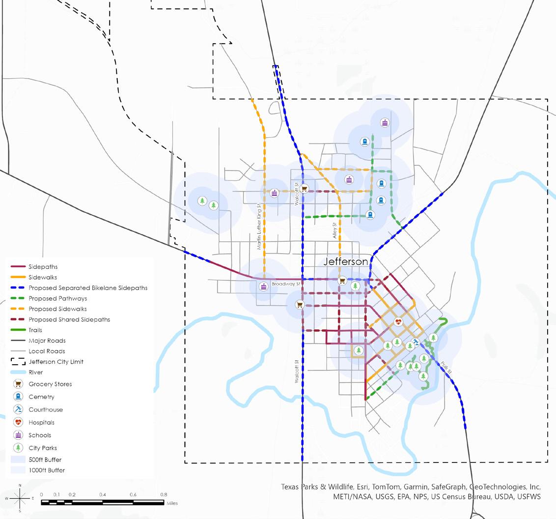
PRIORITY MATRIX
• Developed to provide unbiased prioritization for the City of Jefferson.
Assesses five weighted criteria based on proximity to amenities:
Schools (High Priority, Multiplier: 5)
Parks and Cemeteries (High Priority, Multiplier: 4)
Grocery Stores (Medium Priority, Multiplier: 3)
Churches and Landmarks (Medium Priority, Multiplier: 2)
Public Amenities (Low Priority, Multiplier: 1)
• Sidewalk Segment Scoring:
Segments within 500 ft of amenities: High priority. Segments within 1000 ft of amenities: Medium priority.
Segments more than 1000 ft from amenities: Low priority.
PHASING OF NETWORK DEVELOPMENT
Current Network: 19.59 miles (8.77 miles pedestrian, 10.82 miles bicycle facilities).
• Phase 1:
Focus on facilities within a 500-foot radius of schools, parks, landmarks, and other amenities. Includes bike lane segments less than 3 miles.
• Phase 2:
Develop facilities within a 1000-foot radius of schools, parks, landmarks, and other amenities.Prioritizes segments less than 5 miles.
• Phase 3:
Create facilities beyond a 1000-foot radius of schools, parks, landmarks, and other amenities.
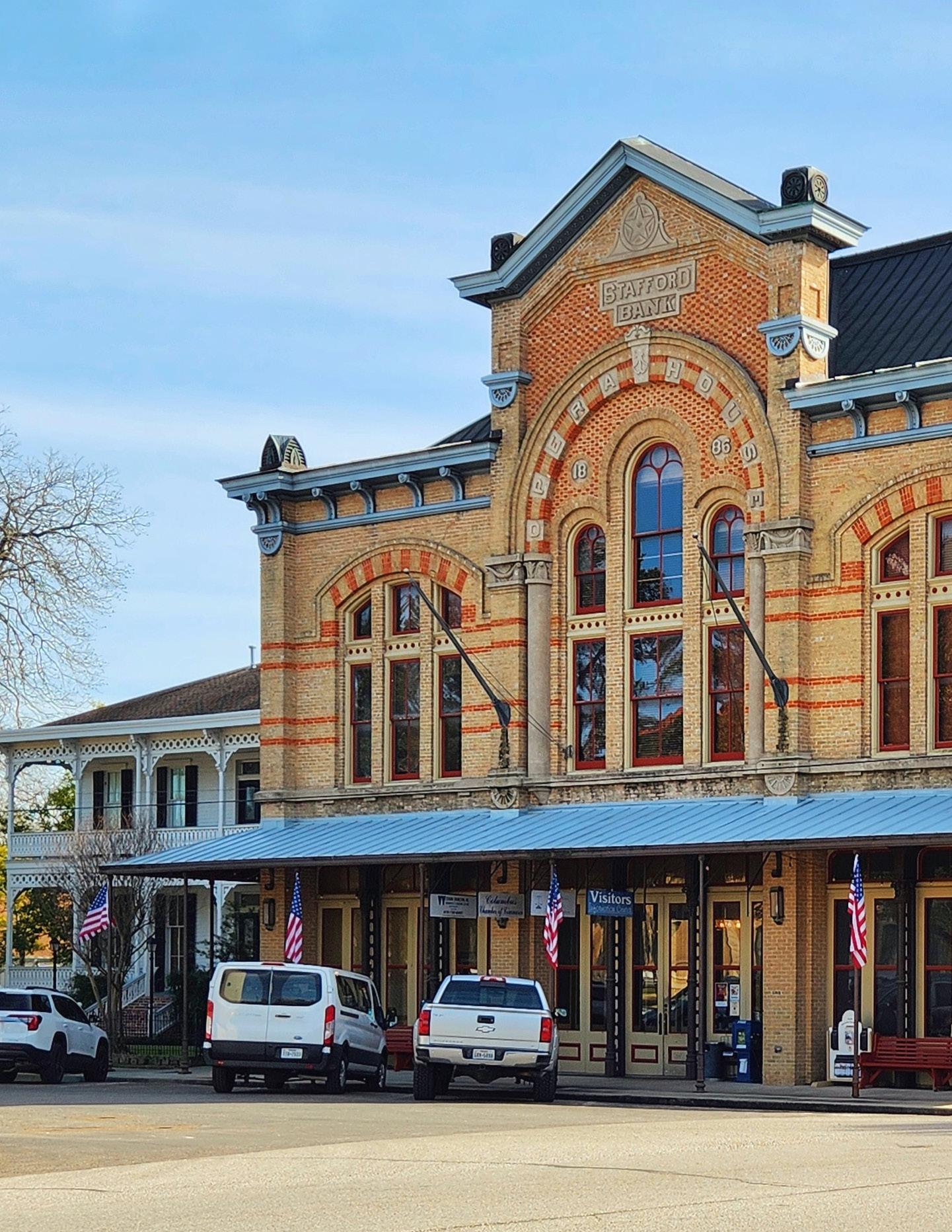
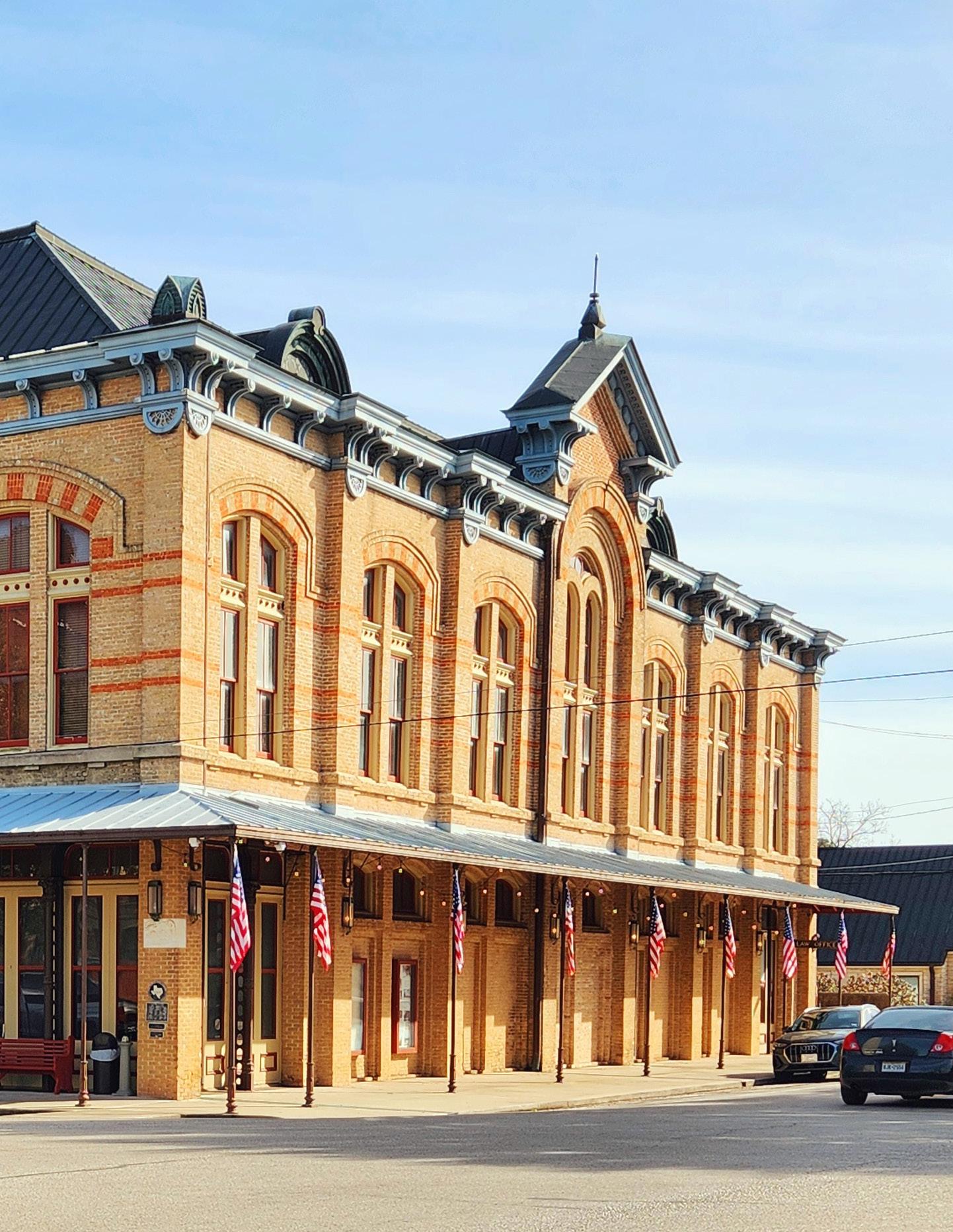
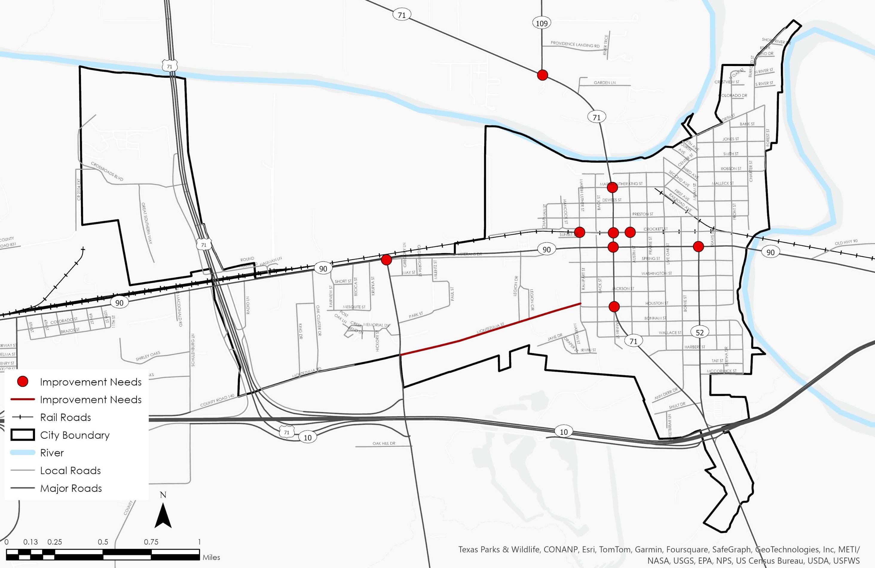
Transportation Plan - City Of Columbus, TX
■ Project Information
Type: Professional Work
Location: Columbus, Texas
Client: City of Columbus, Texas
Project Scope: Recommendation for thoroughfare and transportation strategies.
■ Objectives
• Assess current transportation infrastructure and document findings.
• Create before and after images to illustrate potential improvements.
• Develop a comprehensive plan focusing on pedestrian and bike lane enhancements.
• Promote and enhance pedestrian and bike infrastructure.
• Provide a structured plan for maintaining and improving transport facilities.
■ Background
The City of Columbus, Texas, located between Houston and San Antonio along the IH 10 corridor, has a population of 3,669 as of the 2020 Census. As the largest municipality in Colorado County, Columbus is seeking to improve its transportation infrastructure to enhance road safety and mobility for its residents. In collaboration with Texas Target Communities (TxTC), a program from the School of Architecture at Texas A&M University, the City of Columbus initiated the creation of a comprehensive transportation plan. TxTC’s mission is to support under-served communities by addressing various challenges through community engagement and providing technical assistance. Graduate students from Texas A&M University’s PLAN 678 Transportation Planning Studio and local stakeholders collaborated to identify transportation issues, needs, and opportunities.
Key steps included:
• Community Engagement: Gathering input through public meetings, surveys, and workshops to reflect community priorities.
• Existing Conditions Analysis: Assessing current infrastructure, including roads, pathways, bike lanes, and transit facilities.
• Identification of Issues and Opportunities: Using data analysis and community feedback to pinpoint critical transportation issues and opportunities.
• Development of Recommendations: Creating strategies to enhance road safety, promote multimodal transportation, and ensure reliable infrastructure maintenance.
The plan focuses on three main themes:
• Maintenance Reliability: Strategies for regular upkeep and improvements to ensure safe, long-lasting infrastructure.
• Multimodal Opportunities: Advocating for pedestrian and bike pathways, better public transit, and improved accessibility.
• Traffic Safety: Proposing measures to reduce accidents and enhance safety for all road users.
By implementing these strategies, Columbus aims to create a connected, accessible, and safe transportation system that supports growth and development. The plan serves as a roadmap for future investments, ensuring Columbus remains a thriving, well-connected community.
GOAL 1 – CREATE A RELIABLE AND EFFICIENT SYSTEM
Safe and reliable infrastructure is a priority for any transportation infrastructure. This is accomplished through regular maintenance and inspection to ensure that the quality of the road is at or above standard, and to mitigate damage that is caused by daily wear and tear. The system should also be suited to handle the demands that are placed on it by the traffic load, and other spatial considerations, such as adequate parking.
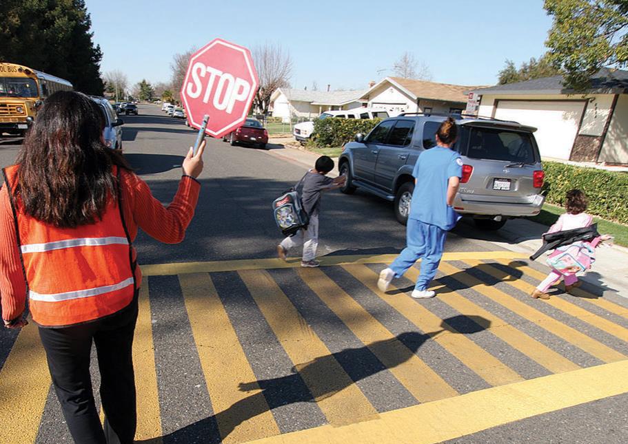
SAFE ROUTES TO SCHOOL
• Created by the U.S. Department of Transportation. Enhances pedestrian safety for school-aged children.
• Promotes physical activity and healthy exercise habits.
• Provides federal grants for walking and cycling infrastructure around schools.
• Supports educational initiatives for students and parents.
Benefits for Columbus
• Ensures safer commutes for students and the community.
• Reduces the risk of pedestrians in roadways.
• Enhances overall safety for drivers and pedestrians. ■ Recommendations
GOAL 2 – ENSURE TRAFFIC SAFETY FOR ALL ROAD USERS
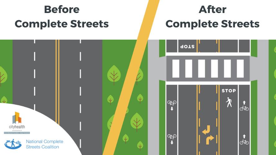
Providing safe routes that accommodate multiple modes of transportation is vital to creating a healthy and robust system. Pedestrians of all ages and abilities need their own space to move comfortably and with dignity to and from their destinations. These pedestrian paths should interact with the road system so that both drivers and walkers understand and appreciate each other’s space. Additionally, there are other services and programs that can help facilitate travel, such as ride and bike share programs, and public transit, that should be included in the multimodal system.
COMPLETE STREETS
• Approach for planning, building, operating, and maintaining streets for all ages, abilities, and mobility choices (pedestrians, cyclists, transit riders).
• Ensures safety and accessibility for everyone.
• Involves a process and approach, not just a single street type.
• Considers community needs, including sidewalks, bike lanes, bus lanes, accessible signals, curb extensions, and roundabouts.
• Tailors interventions to different contexts: rural, suburban, and urban areas.
GOAL 3 - PROVIDE MULTIMODAL OPTIONS AND OPPORTUNITIES
Themed Paths enhance pedestrian and bicyclist safety and accessibility, guiding the creation of streets for all ages and abilities. This approach supports city growth, focusing on safety, comfort, and equity. Implementing these designs improves traffic safety, reduces congestion, promotes healthy lifestyles, and boosts economic development. Map below shows proposed facility locations and types. Recommendations are based on national best practices, with key resources from the National Association of City Transportation Officials, the American Association of State Highway and Transportation Officials, and the Federal Highway Administration.
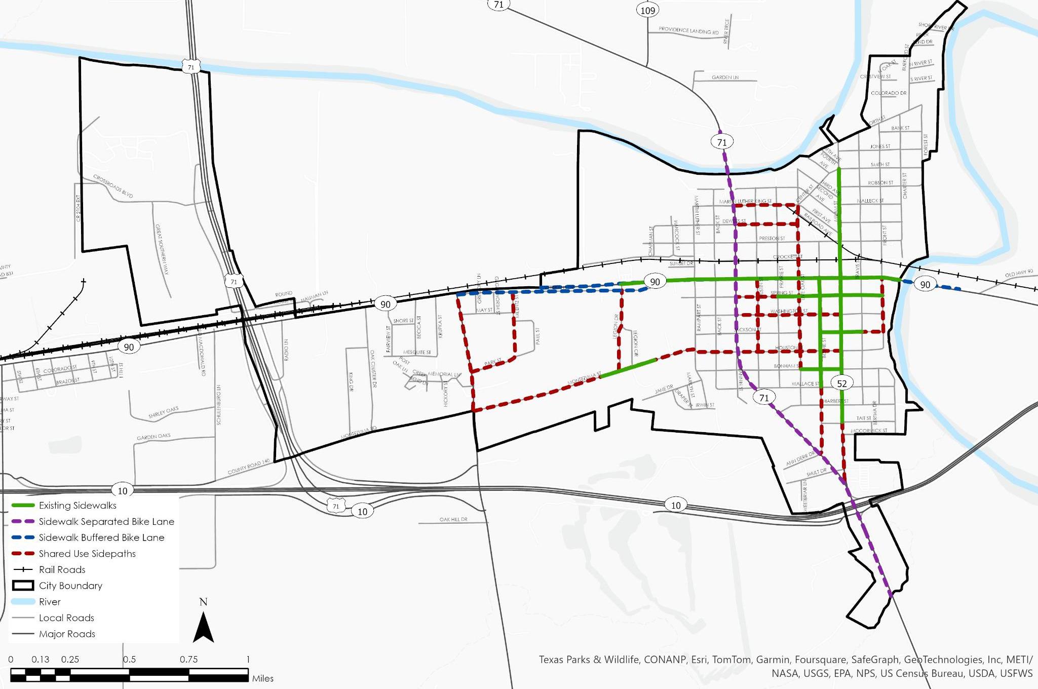
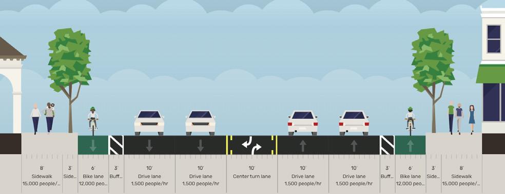
Local and Neighborhood Roads - Shared Use Side paths
Arterials - Sidewalks with Buffered Bicycle lanes
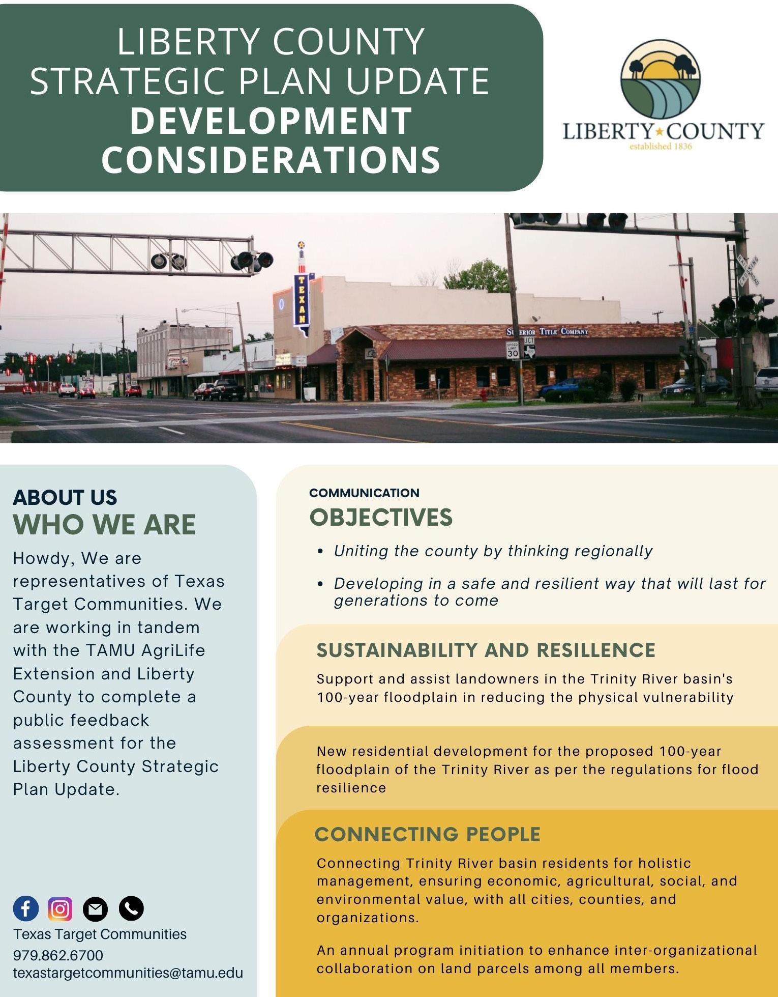
Strategic Plan Update - Liberty County, TX
■ Project Information
Type: Professional Work/PLAN 661
Location: Columbus, Texas
Client: Liberty County, Texas
Project Scope: Promote sustainable, resilient development through regional collaboration, community engagement, and flood-proofing initiatives.
■ Background
■ Objectives
• Gather public feedback to align the strategic plan with community needs and aspirations.
• Promote community engagement and inter-organizational collaboration for effective implementation of the plan.
• Encourage development that is safe, sustainable, and resilient to natural disasters, particularly flooding.
Liberty County is experiencing growth in population and land development. Historically reliant on natural resource extraction, the county now faces challenges related to sustainability, public infrastructure, and vulnerability to natural disasters due to its proximity to the Gulf Coast and the Trinity River. The existing 20162036 Strategic Plan addresses these challenges but requires an update to incorporate new insights, regional collaborations, and innovative solutions to ensure a resilient future.
The county’s transportation network facilitates the movement of people and goods, but gaps in public infrastructure, such as inadequate public hospital services, need to be addressed. Additionally, the threat of flooding and other natural disasters necessitates a focus on resilient development practices.
Key steps included :
• Establish an organization with membership open to all cities, counties, and organizations located in the Trinity River basin.
• Initiate an annual program to improve inter-organizational collaboration regarding land management.
• Promote new residential development in the 100-year floodplain of the Trinity River according to flood resilience regulations.
• Design a cooperative regulatory framework for new residential construction, including flood-proofing and drainage systems.
• Assist landowners in the 100-year floodplain in reducing the physical vulnerability of their buildings and infrastructure.
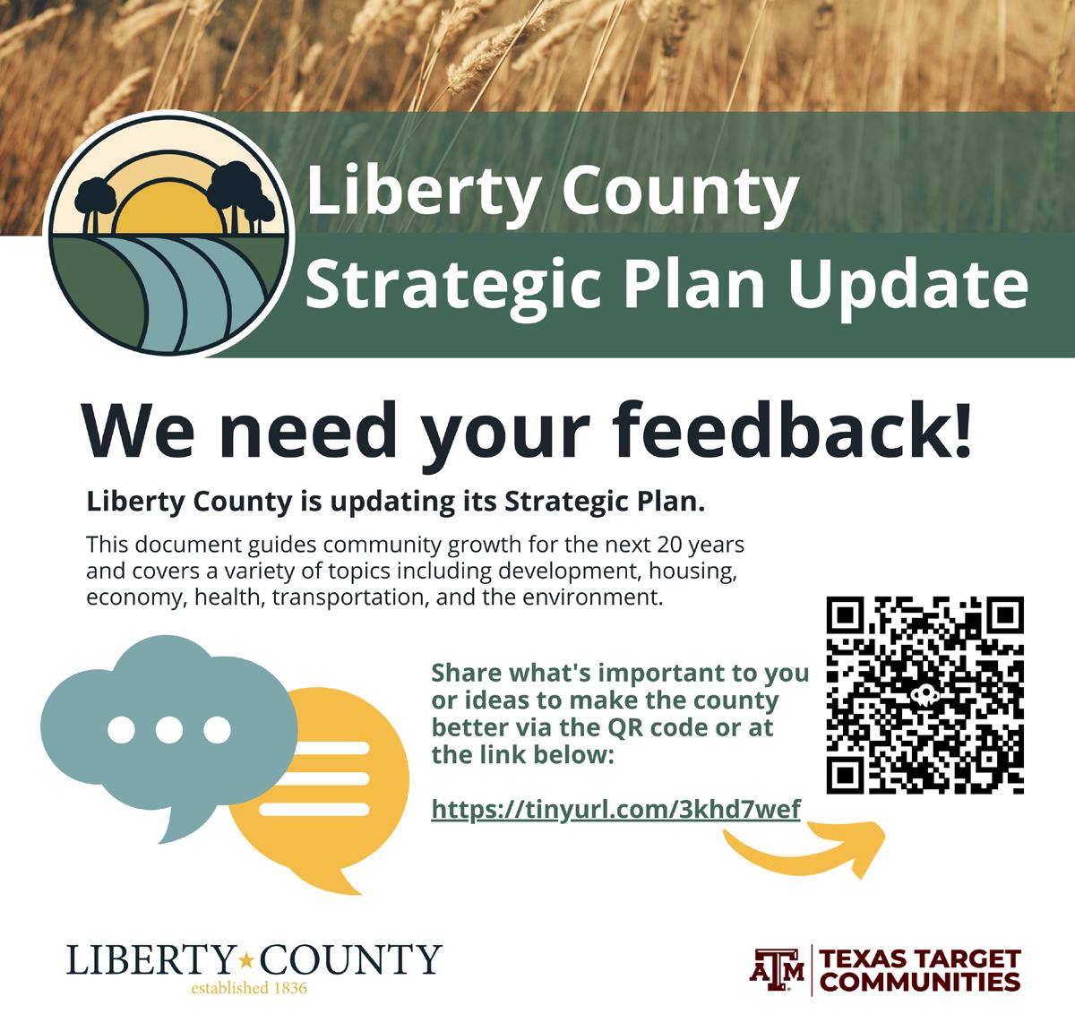
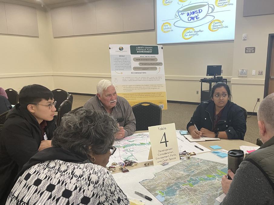
• Conduct public feedback sessions and use platforms like the Social Pinpoint Idea Wall to gather input from residents.
• Address concerns and incorporate community feedback into the strategic plan update.
• Develop an implementation timeline for the updated strategic plan.
• Establish monitoring mechanisms to ensure the effective execution of the plan and adjust strategies as needed.
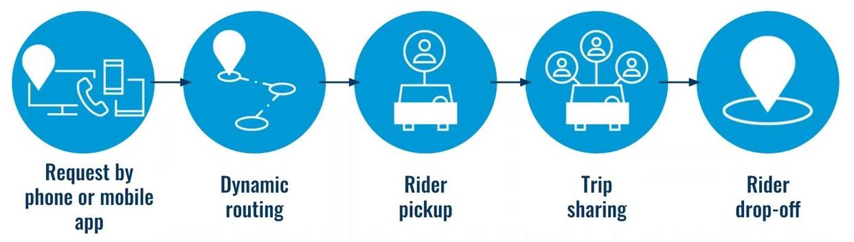
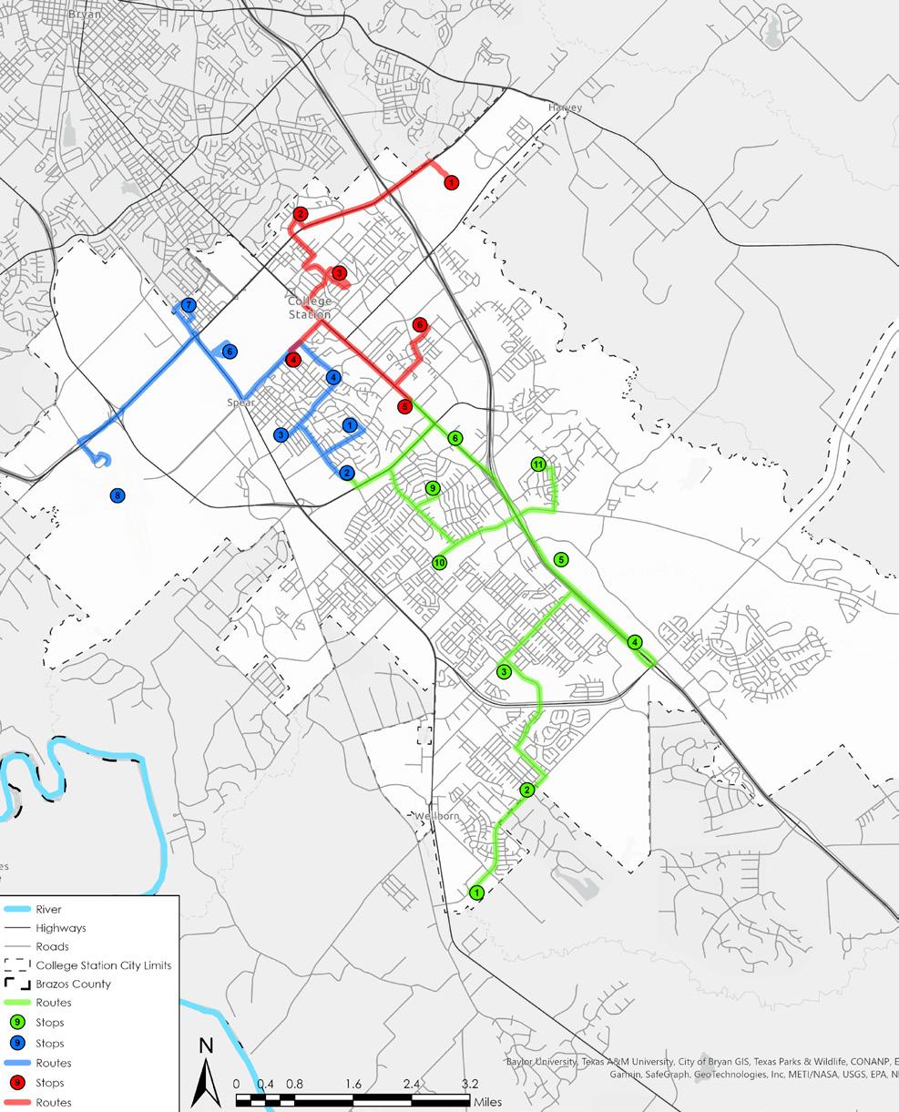
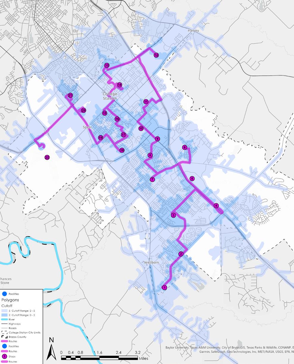
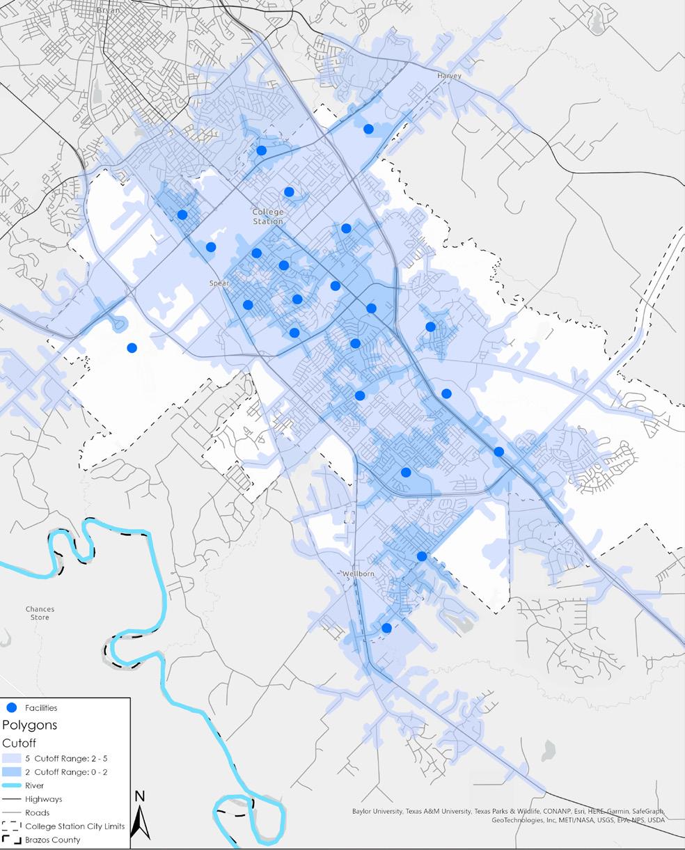
Micro Transit Service Solutions - College Station, TX
■ Project Information
Type: Professional Work
Location: College Station, Texas
Client: City of College Station, Texas
Project Scope: Recommendation for public transportation strategies to enhance first mile-last mile connectivity through microtransit solutions.
■ Background
■ Objectives
• Assess the challenges and benefits of microtransit in addressing first and last-mile connectivity in College Station.
• Develop a dynamic network analysis approach to optimize microtransit service areas and routes.
• Analyze the role of emerging technologies (e.g., ride-sharing services, autonomous vehicles, real-time data analysis) in enhancing microtransit services in College Station.
The city of College Station, home to Texas A&M University, faces unique transportation challenges due to its demographics and commuting patterns. With a significant portion of the population being students, the demand for flexible and efficient transportation solutions is high. Traditional fixed-route transit systems often fail to meet the diverse and dynamic needs of the community, particularly for short-distance travel between homes, the campus, and other local amenities.
Microtransit services, which offer on-demand, flexible routing options, present a promising solution for bridging the first and last-mile gaps in the city’s transportation network. This project aims to explore the feasibility and effectiveness of implementing microtransit solutions in College Station by leveraging case studies, demographic analysis, and technological advancements.
Key steps included:
• Data Collection and Preparation:
Acquire spatial data including road networks, amenities like schools, universities, local grocery stores, and parks.
• Network Dataset Creation
Develop a network dataset within ArcGIS using the collected data to specify stop locations and any restrictions.
• Data Integration and Attribute Assignment
Assign appropriate attributes to network elements such as time, distance, travel, facility points, etc.
• Service Area Analysis
Use the ArcGIS Network Analyst extension to find service areas around any location on a network. Create concentric service areas to evaluate accessibility at various intervals (e.g., 2-minute and 5-minute drive times).
• Route Analysis
Perform route analysis to determine the best routes based on the chosen impedance (e.g., time, distance).
Benefits for College Station
• Microtransit improves accessibility by filling gaps in traditional transit, making it easier to reach jobs, schools and amenities.
• On-demand service offers flexibility and efficiency, reducing wait times and long walks.
• Less traffic congestion due to fewer cars on the road.
• More sustainable with potentially electric vehicles.
• Boosts economic development by attracting new residents and businesses.
• Provides equitable transportation options for all.