
KPortfolioayaUmesh
VENKATRAMANANINTERNSHIPS ASSOCIATES Work Content parks, Revit 3D Modeling, Site visits Duration:Location:Position: KURIAN GEORGE ASSOCIATES Work Content drawings using Revit, Site Visits Duration:Location:Position: CENTRO COOPERATIVO DI PROGETTAZIONE Work Content Drafting, Photoshop Duration:Location:Position: CUrriCUlUm Vitae Kaya Umesh DOB: 14 Nationality:March,1995Indian MUDPROFESSIONALHIVESTUDIO Work Content: Design, Furniture Design, Project Working drawings, Site Position: Junior Architect Location: Dharmapuri, Duration: May 2018SCHOOL OF ARCHITECTURE Work Content: Student Position: Part-time Teaching Location: Vellore, India Duration: June 2018 LANGUAGESCONTACT SpanishItalianHindiEnglish20153,MilanoVia+39kayaumesh@gmail.com3313228957QuartoCagnino,02,


PROFESSIONAL EXPERIENCE Design, Landscape design, Project management, Site Dharmapuri,ArchitectinstructorIndiaAugust2019 ARCHITECTURE (V-SPARC) Student facilitator, Lecturer Teaching Assistant India- November 2018 POLITECNICOEDUCATIONDI MILANO, ITALY MSc in Sustainable Architecture and Landscape Design 2019- 2022 ANNA UNIVERSITY, INDIA Bachelor of Architecture 2013-2018 FRACTALWORKSHOPSWORKSHOP Instructor: AR.Takbir Fathima Location: Chennai, India Year: 2014 ADVANCE REVIT AND AUTOCAD COURSE Instructor: Autodesk Location: Chennai, India Year: 2015 CHAMPANEER HERITAGE PROJECT Instructor: AR. Karan Grover Location: Ahemdabad, India Year: 2015 I am an enthusiastic, hardworking and open-minded learner. I look forward to broadening my horizons in different architectural fields and gaining practical knowledge about the design and implementation of projects with sustainability at the core. I’m fascinated by the scope of landscape in vernacular architecture, incorporating indigenous techniques in the construction of buildings and native trees, herbs and medicinal plants into the living space so that the sustainability of communities can be addressed holistically.
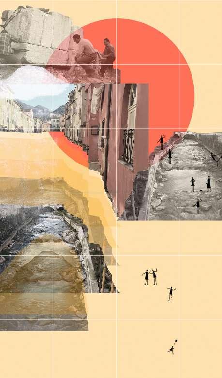
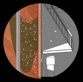
lsreimaginingtrUCtUandsC The case di mori geetha & sUresh residenCe An ExperimenT wiTh mud Contents 1 2


eimagining Post-indUstral Ures throUgh CaPe-Based strategies case of former monTecaTini in rovereTo, TrenTino refleCt/rejUVenate/reConneCt reviving The ciTy of carrara 3

a residenTial projecT in rural india ConstruCted ProjeCt Chief Architect : Meenakshi September, 2017- May, 2019 geetha & sUresh residenCe an exPeriment with mUd


This house is located on a farm in a small village called Nagar koodal, Dharmapuri, India. It is located in one corner of large flat farmland with views towards a small creek bordering the Theproperty.design scheme is in the shape of a spiral with a circular central courtyard. In the centre, there is the water harvest ing tank of 30000 litres beneath the circular courtyard. The entrance to the building is through the Living area. The bed rooms, kitchen and dining areas are arranged radially around the courtyard. The client wanted to reduce water consumption and cause minimal damage to the surrounding environment. For this reason, it was decided that the house would be constructed with locally available granite stone blocks and bricks using mud as the mortar. The roof of the ground floor was done using Laurie Baker’s filler slab technology. The walls on the first floor are also done using Laurie Baker’s rat-trap bond with country bricks. To minimize the water consumption of the household, dry composting toilets were proposed. Further, the grey water from the kitchen and bathing area is to be filtered and used in the kitchen garden.
design
oVerView site Plan & strategy 1. Garage 2. Outdoor siting 3. Chicken coop 4. Terraced Vegetable 5. Grey water outlet 6. House 7. Indoor 9.8.EntranceCourtyardRainwaterharvesting

1 2 4 4 4 5 7 9 8 6 3 0m 5m siting Vegetablearea Gardens outlet with plants Courtyardharvesting pond


Since the clients use natural soaps and detergents the grey water from the kitchen and bathrooms is directed into a filter. The filter is a concrete box with an inlet at the top and an outlet at the bottom. The concrete box is then filled with layers of charcoal, sand and gravel. The grey water is then allowed to filter through these layers before being used to irri gate the plants in the garden.
On the inside, the walls are plastered with traditional mud plas ters and artworks using different combinations of lime, earth colours and ash. Fixed furniture was proposed over the com mercially available counterparts to further reduce the impact on the environment.
Collecting Pit Water Outlet
Composting toilet is a type of dry toilet that pre dominantly uses an aerobic processing system to treat human excreta by composting or managing aerobic decomposition. These toilets generally use little or no water and may be used as an alternative to flush toilets. The human excreta is usually mixed with dry leaves, sawdust, coconut coir, soil or peat moss to facilitate aerobic processing liquid absorp tion and odour mitigation. Most composting toilets use slow, cold composting conditions. The toilets produce compost that will be used on the farm to enrich the soil.
GREY WATER TREATMENT
GreyCharcoalSandGravelWallFloorShutterWater Inlet Grey
COMPOSTING TOILET
design detail groUnd floor Plan


0m 5m Verandah CoUrtyard liVing sPaCedining sPaCe KitChen master Bedroom Bedroom ComPostingtoilet stUdy + 0.15m + 0.30m + 0.30m + 0.30m + 1.05m + 1.05m + 0.45m + +0.15m0.45m + 0.45m + 0.65m + 0.00mA'AB B'


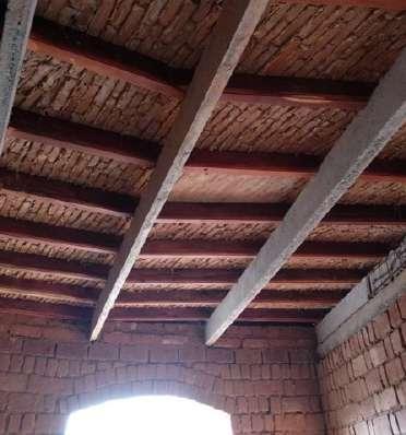
Madras Terrace roof is a traditional roofing/flooring tech nique practised predominantly in southern India. A small brick called “aachhikal”, wood and lime is used in the construction. The aachikal brick is laid on edge across in a diagonal fashion and plastered with lime over wood en beams. A layer of brickbat kadukai water and lime is applied over the bricks. Finally, a layer of tiles is laid to make the roof waterproof.
Wooden rafters (5cm x 12cm at 45 cm intervals) Wooden beam ( 12cm x 20 cm)cm20cm12cm305cm
Tiles
THE FILLER SLAB
Steel Bars 6mmØ Section of Filler slab Arrangement of tiles Steel Bars 8mmØ30cm 10cm Concrete
A Filler slab is a Reinforced Cement Concrete slab that uses filler material embedded in it so that the weight of the slab and amount of concrete used comes down. Pots, Terracotta tiles, Coconut shells and bottles are some of the materials used in the filler slab system. The technique works on the concept of removing unnecessary concrete in the tension zone and filling it with lightweight and in expensive materials. Revolutionised by Laurie Baker in India, these slabs increase the thermal comfort and add an interesting aesthetic to a
space.Mangalore
design detail first floor Plan
MADRAS TERRACE ROOF
45- 60 cm Terracotta tiles laid with lime Brickmortarjalli& lime with ‘kaduka’ water Brick laid with lime mortar Brick laid with lime mortar (inclined as well as diagonally in plan)
To reduce the amount of concrete used in construction roofing techniques like FILLER SLAB and the traditional MADRAS TERRACE ROOF are used. To further reduce the usage of concrete in the building it was decided to use arched openings and thereby avoid the need to cast a lintle beam.


oPen terraCe aV room/ familysPaCedining sPaCe Below oPen terraCe Bedroom Bedroom ComPostingtoiletBathroom liBrary + 3.45m + 3.45m + 3.90m + 3.90m + 3.90m + 0.45m + 3.45m CoUrtyard Below A'AB B'

0m 5m design detail eleVations & seCtions West elevation south elevation


section aa' 0m 5m


design detail
PersPeCtiVe seCtion
Permaculture techniques have been implemented in the gardens surrounding the house. Indigenous species of fruit trees and shrubs are planted along with seasonal vegeta bles. The kitchen garden is also part of the permaculture garden. This method is adopted since the project is located in a dry, arid region of India with scanty rainfall and using exotic species as a part of the landscape design would not be relevant to the context.

Madras Terrace Roof Rat-trap-bond Wall Filler Slab Cob wall with granite blocks in the rainwaterwatertoCanalOpencollectionUndergroundexteriorrainwatersumpCourtyardaroundthehousecollecttherunoffrainanddirectsittotheharvestingpond

Rainwater harvesting pipe en closed in a brick column View of the central courtyard during construction prewithwalls,cobandstonethick12” staircasecast theinlaidbrickarewallsfloorfirstThe insulation.theimprovetorat-trap-bond intoiletdryCompost floorFirstthe intoiletdryCompost floorGroundthe design detail PiCtUres - deVeloPment of the ProjeCt


Pouring concrete for a 6” thk filler slab Filler slab using Mangalore tiles Natural paints made by com bining lime, earth colours and ash are used to make murals on the wall. Mathesupportingbeamsconcrete&Wooden RoofTerracedras spacsittingin-builtwithspace,livingtheofView walltheinspacesstorageandes theandkitchentheofView tablediningin-built


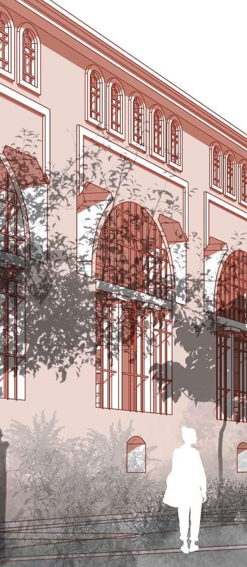
The case of The former monTecaTini di mori in rovereTo, TrenTino. Post Graduate thesis Supervisor : Gaia Piccarolo Partner : I-Chen Hung 0ctober, 2021- April, 2022 reimagining Post-indUstral strUCtUres throUgh landsCaPe-Based strategies


Site size: 170,000.sq m Site location: Mori(TN), Italy Typology: Industrial complex Period of construction: 1927-1928 Decomissioned year: 1983 Cause of abandonment: Environmental Pollution ProjeCt details site introdUCtion
Montecatini di Mori was built between 1927-1928 by the Milanese industrial group “Montecatini” in agreement with the German company “Vereinigte Aluminum Werke” as the factory to produce alu minium. It was the first plant in Trentino that was supported by hydroelectricity generated on-site. In March 1983, the closure of the plant became definitive due to the impact it had on the environment. This complex, which today is seen as one of the symbols of industrial archaeology, is a place slowly buried in the memories of the locals. Not only does the site have beautiful industrial structures, but it also represents livelyhood of the people who worked there in the post-war period. Hence, the building has obtained the recognition of the historical-artistic interest of law n ° 1089 of 1939 in tended as a landscape - monumental asset defined by article 94 of the provincial town planning law. Currently the site is abandoned, with old furniture, industrial objects scattering around, and the plants thriving freely. We were hoping the complexity of the surrounding condition can be turned into an advantage, that correlates with its historical identity, as well as its strategic location in Trentino’s scenic landscape, to provide the design opportunities. It also allows us to create a space which succeeds in keeping the past alive while providing new use and social values to the space through the adaptive reuse of the industry site.

Analysing the landuse maps of Montecatini di Mori and the surrounding valley helped in giving a better understanding of the site and the kind of activities that take place around the site. The conclusions we drew from the landuse maps helped in deciding the function that could take place in our site.
0 500m 1000m 2000m analytiCal maPPing- xl sCale land-Use maP


1-Project

0 500m 1000m 2000m analytiCal maPPing- xl sCale ConneCtiVity Studying the connectivity of our site to Rov ereto and the nearby valley was important to determine the effectiveness and accessibility of our design proposal at the ex- alu metal site .

1-Project

0 analytiCal maPPing- l sCale landUse, ConneCtiVity & aCCessiBility
The map depicts the landuse, connectivity and accessiblity around the site. The map also indicates the site’s relationship to the Natura 2000 and the existing entrances into the site. Overlaying the informations from landuse map, connectivity map and by analysing the accessibility to the site in a more zoomed in scale helped in understanding the complexity of the sites function, location and importance to the surrounding landscape.


Montecatini di Mori 1-Project


The new micro-ecosystem is formed through time on the hard pavement, espe cially after the cease of human activities. The moss came as the pioneer species, it’s a type of Bryophytes, that doesn’t require soil to survive, and it plays the role of a buffer for other plants, which live alongside and benefit from the water and nutrients that bryophytes collect.
maPPing- m sCale distriBUtion
analytiCal of Vegetation


0 50 100 200 TreesBushesMossGrassWaterBuildings


designProPosal ConCePt
De-industrialisation, one of the many consequences of industrialisation, has physically manifested itself in the form of abandoned, derelict industrial sites scatted across many urban and semi-urban areas in most industrialised countries. These spaces which we identify as “terrain vague” are niches in which alternative ecological processes take place, allowing certain species, which are no longer in a human-controlled environment, to take over the landscape and claim it as their own. These “terrain vague” become places of wildness and to fully appreciate this new kind of beauty and to respect the laws of nature we had decided to create a landscape out of the industrial ruin. We have used ideas like the “ smallest possible intervention” and “do as much as possible for, as little as possible against “ in an attempt to create a landscape made out of industrial debris where the existing buildings (architecture ) are perceived as elements of landscaping. The landscape proposal aims to be an open-ended design approach which responds to and accommodates natural process es. The design strives to nurture the spontaneous nature that already exists on site, encouraging the visitors to elicit an appreciation for nature, its wholeness and diversity. The project is a reflection and interpretation of ideas, principles and design philosophies put forward by Gilles Clément, Peter Latz, Michel Desvigne and Catherine Mosbach.
A proposal for man and nature to coexist in the site
The factories operating in the Industrial site
The site abandoned and nature taking over the site

& strategy maP
Redefine the limitation between human, architecture and nature -using a scientific method to introduce the outdoor landscape inside the architecture, and creating the ambiguity of the border. - stepping into the nature in a humble way.
Phasing of the project Site opened to the public in the first phase to encourage people to create a dialogue with the site and gradually change how the site is perceived by people. Physical Connection Create physical connections both within the buildings and outside the Proposebuildings.an elevated pathway which will provide an ever-changing perspective of the site and its Createsurroundings.aPath of Reminiscence that aids in narrating the history of the site to visitors.
Inside/ outside landscape
Community Participation A place where people from different backgrounds can come together to interact with the site and each other. Participatory activities like community gardens, orchards and beekeeping.Become a place to lean about landscape awareness.
mainProPosalstrategies
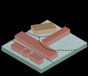
Boosting indigenous species Using the indigenous species and integrating existing plants and trees into the landscape design. Creating segments on the site Dividing the site into smaller segments based of the functions allotted to each building. Using landscape to transform the existing buildings both horizontally and vertically gradually through different intervention phases.
Smallest intervention Implementing the smallest possible intervention strategy to use minimal resources to transform the buildings and the surrounding landscape. Existing condition as backdrop Taking advantage of the dramatic industrial ruins against backdrop of surrounding mountains to create a unique performance area where the vegetation is the permanent performing artists and humans are the temporary artists.


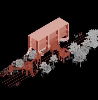
DivisionZoneDesignZoneBuilding1area2of2 zones NatureHumanhumanNaturalActivityPathElevatedElevatorStairsEntranceorramppathofreminiscencezoningzonewithinteractiontrailintonatureenterthe artificial area Building Zone 1 Design area Zone 2 Division of 2 zones Entrance Stairs or ramp ElevatedElevator path Path of reminiscence Activity zoning Natural zone with human interaction Human trail into nature Nature entering the artificial area


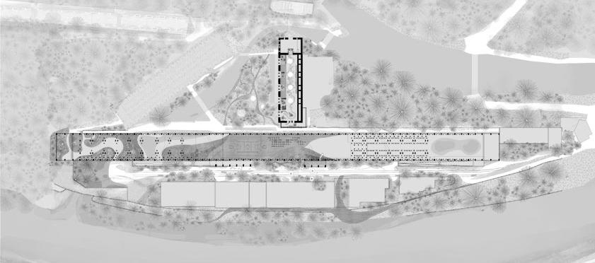
8 15 14 9 A 1. Office and Entrance 2.ZoneExhibition Room 3. Skatepark 4. Rock Climbing & 5.ParkourChildren's Indoor Park 6. Trampoline 7. Basketball 8. Cafe 9. Library11.10.IndoorRiverfrontClassrooms masterProPosal Plan

1 2 4 351067 20 16171819 13 11 12 A'BB'Trampoline Park Basketball Court IndoorCafe LibraryClassroomsRiverfrontLandscapeDeckand 12. Path of Reminiscence 13. Children's Outdoor 14.ParkBrick Riverfront15.InstallationWallsRamptowards 16. Reception of Wellness 17.ZoneElevated Platform 18. Indoor Contemplation 19.PathTea Room 20. Outdoor Meditation Zone 0 25 50 100


seProPosalCtion aa’ Keymap longitudinal section aa' plan
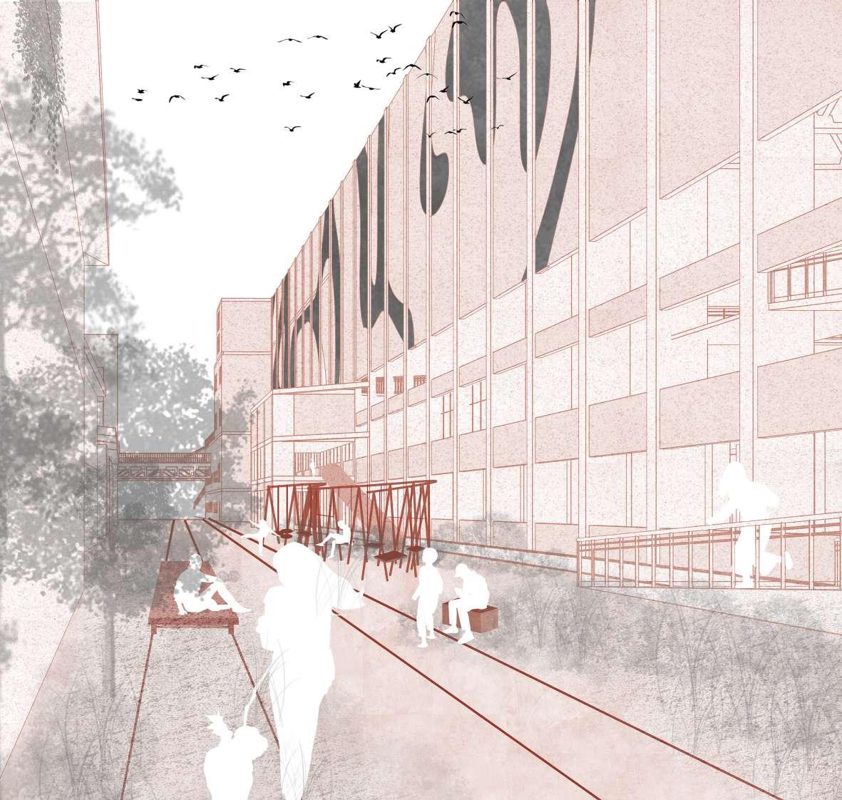
Bricks Installation: Acting as an extention of the brickwalls from the former Oven Room A, that is transformed into Sport zone. The two brick walls interact with the greenery, which provide different perspectives and ways for people to interact with the landscape.
Resting Area 2: With benches reusing concrete columns that are cut down asOventransformationduringoftheRoomA,andrailrestingfurnitures.


Path to the Riverfront: A division from the path of reminiscence to the riverfront, providing different natural scene to people.
Resting Area 1: Close to the entrance and next to the exhibition room, providing furnitures transformed from the relics for people to rest.
EntranceRoomExhibition
Children's Outdoor Park: Small playground elements extending from the indoor children's park, privide an active atmosphere, and a way for the children to interact with the landscape.
0 25 50 100 reusing the thethattheformerrailtrollies


BuildingsOfficeAdigeRiverHighwayA-22 CenterSport seProPosalCtion BB’ Keymap longitudinal section BB' The longitudinal section BB’ cut in the East- West direc tion, showing the how the site is surrounded by rich natural environment, and how it’s isolated from the other part of the valley by roads and Adige river. It also shows the entrance from Primary Road 90 and the sequence of experiencing the zone I design. from the moun tain to the river.


0 25 50 100 Wellness Center (Former Hydroelectric Plant) RoadPrimary90Entrance

design details sPort ComPlex

GREENNATURALROOF INTO THE BUILDING
LIGHT INTO THE BUILDINGARTIFICIALOPEN
OPENINTRODUCE PEOPLE INTO NATURAL LANDSCAPE ARTIFICIAL AREA NATURALSEMI-NATURALAREA
ARTIFICIALOPENCLOSE
SEMI-OPENCLOSEOPENINTRODUCE PEOPLE INTO NATURAL LANDSCAPE ARTIFICIAL AREA NATURALSEMI-NATURALAREA
TOP1FGF
GREENNATURALROOF
OPENINTRODUCE PEOPLE INTO NATURAL LANDSCAPE ARTIFICIAL AREA NATURALSEMI-NATURALAREA
design details sPort ComPlex strategies and sCheme TOP1FGF 0°0° 15°15°21° 15° 21° 0° 0° 0°0° 15°15°21° 15° 21° 0° 0° 0°0° 15°15°21° 15° 21° 0° 0° TOP1FGF Scheme of Functions Each floor has a variety of functions to keep the visitors engaged. Scheme of relative thermal comfort In each floor the ratio of the openings to the walls determines the thermal comfort of the area. Scheme of natural & artificial surfaces On each floor, the line between the natural and artificial surfaces is blurred resulting in a structure where there is no definitive distinction between the two.
SEMI-OPEN
SEMI-OPENCLOSE
LIGHT INTO THE BUILDINGARTIFICIALOPEN
LIGHT
GREENNATURALROOF
RooftopRampGF1F&Facade

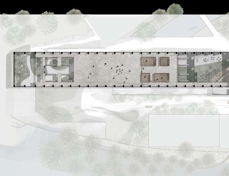
Indoor Natural Leisure Path: The path that guide people into more natural area of the site. Cafe: Provide people supplements after exercise, and a place to socialize. Basketball Court: In the semi-closed area, people a basketball court use all year. design details sPort ComPlex groUnd floor details Keymap ground Floor plan section cc' c Z oom in details


Children's Indoor Park: Taking advantage of industrial strructure to provide 3 different interesting slides for children Parkour: Taking advantage of the industrial structure, reusing the columns as parkour facilities, located in the roof open area.
Skatepark: Situated in the roof open area, street activity elements to invite people into the site. c'
0 20 40 80 area,courtprovidethatcan Trempoline: Trempolines part is in the semiclosed area, providing the use for all year.


Performing Area: Using the dramatic industiral building as backdrop, which gives it a different performing experience than other performing theatre. Dance Rooms: Closed rooms with opportunities to practice undisturbed. design details sPort ComPlex first floor details Keymap First Floor plan section cc' Z oom in details c


windows, giving practice inside Supporting volume: Volume with elevator, stairs and ramp connecting to different floors. It also contains supporting facilities like storage rooms, toilet, changing rooms. Rockclimbing wall: The dramatic industrial scale is perfect to be used for the indoor rockclimbing activities. 0 20 40 80 c'


Removing design details sPort ComPlex roof leVel details Keymap rooF plan Front elevation
Transition of the Moss Brick Wall: The perforated walls provides the light inside the building, giving an interesting experiences when the visitors walk on the ramp. Original brick wall


0 20 40 80 Removing bricks Applying moss paint Moss taking over the facade


design details sPort ComPlex tViewsheChildren’s Play area inside the sPort ComPlex has a mixtUre of natUrUal & artifiCial sUrfaCes. Keyplan


design details sPort ComPlex Views Keyplan the leisUre gardens - where natUre is BroUght ComPletely into the BUilding BlUrring the oUtside and inside.


design wellnessdetailsZone

21°21°21° 21°15°21° 15° 0° 46°30°12° GFGF1FGFOutdoorArea TOP1F1F design details wellness Zone strategy and sChemes Scheme Each floor of visitorsfunctionsengaged. thermalScheme In each floor of the openings walls area.thermaldetermines Scheme of natural & artificial surfaces On each floor, the line between the natural and artificial surfaces is blurred resulting in a structure where there is no definitive distinction between the two. The outdoor area is a zone where the presence of man is the artificial element. There are no built structures.
1FGF of Functions floor has a variety functions to keep the engaged. of comfortrelative floor the ratio openings to the determines the comfort of the

design gwellnessdetailsZoneroUndfloordetails 7 Keymap ground Floor plan

0 9 56 4 3 2 1 8 5 10 20 1 1. Entrance Zone 2. Transition Area 3. Relaxing Hammock 4. Tepidarium 5. Caldarium 6. Frigidarium 7. Changing Room and Toilet 8. Contemplation Platform 9. Contemplation Path


design fwellnessdetailsZoneirstfloordetails 6 First Floor plan section dd' Keymap d


0 5 10 20 1. Tea Room 2. Transition Area 3. Indoor Contemplation Path 1 2 3 4 44 5 4. Elevated Platform 5. Indoor Stream 6. Reception d'


design gVwellnessdetailsZoneiewsroUndfloorView of the former hydroeleCtriC Plant that is now the wellness Zone. the oPenings of the water tUrBines are CoVered with a net and Can Be Used as hammoCKs. Keyplan


design tVwellnessdetailsZoneiewshefirstfloorofthe former hydroeleCtriC Plant hoUses the Path of ContemPlation. a deliCate stream of water -a gentle reminder of the imPortanCe of water in this indUstrial site & iPso faCto to the City of roVereto -weaVes throUgh the BUilding floor. along this steam of water, Platforms of moss and grasses are PreCarioUsly PlaCed Creating different Kinds of sUrfaCes UPon whiCh the Visitors Can walK while meditating. Keyplan


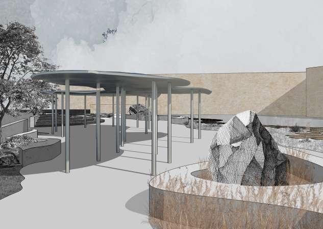
carrara, iTaly Post Graduate thesis Supervisor : Prof. Sara Protasoni Prof. Floriana Pergalani Partner : I-Chen Hung September, 2020- February, 2021 refleCt/rejUVenate/reConneCt


During the preliminary investigation of Carrara, we noticed that the river Carrione was often completely detached from the existing city fabric. This lack of integration into the city led to the degradation of the river, the polluted water being the biggest bane. While the flood walls are vital to the safety of the public during floods, it visu ally cuts off the river. This led us to our concept of making the river more visually accessible which guided us to explore the other kinds of barriers present at our sites, like the hydrological barrier and the anthropogenic barriers. The concept evolved from the river. The idea is to create a space where visitors experience the river without physically accessing the river. This is achieved by creating islands of tall grasses, which when swaying in the breeze, will create ripples similar to water.
Site location: Carrara, Italy details site introdUCtion
ProjeCt
Carrara has a long history of mining for marble. The marble extracted from Carrara has been used to create many masterpieces, like the David of Michelangelo. However, the activities of the quarry have polluted the river Carrione over time. The river Carrione is now cut off from the remaining city by flood walls or buildings which is why the river is isolated and desolated.


SURFACE PERMEABILITY
The river Carrione is prone to flooding. Analysing the areas at flood risk helped in understanding the importance of the flood walls. This study confirmed that removing the flood walls to create physical access to the river had potential risk, hence the proposal had to work within that parameter and create a space where people could interact with the river visually.
AREAS UNDER FLOOD RISK
Analysing the materials that cover the surface helps in understanding the permeability of the various surfaces. This aids in understanding the cause of flooding and provides solutions that could help avoid the catastrophe.
Vegetated surfaces
analytiCal maPPing PermeaBility & Barriers
Asphalted surfaces have very low permeability. Hence large parking lots can be redesigned to increase permeability.
Asphalted surfaces
The green areas have high water permeability, however the green areas are scattered and lesser in area. In order to avoid flooding the green ares must be increased. Cobblestoned surfaces
A major part of the historical center of Carrara is covered with cobblestones, which has a low permeability. This increases the flood risks.


Urban LimitingFabricBarriers- Buildings Limiting Barriers- Flood-wall Roads connecting
The river is not physically accessible at any point due to the flood walls. However, removing the flood walls increase the flood risk and hence the river cannot be physically accessible.
Lowest Permeability -Buildings Low Permeability -Cobblestones Low Flood Risk
Though the river runs close to the historic center of the city, it is visually cut out due to the high flood walls.
Lowest Permeability -Asphalt High Permeability -Vegetation High Permeability -River High Flood Risk Human-eyeLevel VISUAL BARRIERS
Human-eyeHuman-eyeLevel HeightRailingRailingHeight Base Line BaseLine VISUALLY ACCESIBLE Human-eyeLevel LevelHuman-eyeHuman-eyeLevel RailingHeight HeightRailingRailingHeight Base Line BaseBaseLineLine VISUALLY ACCESIBLE VISUALLY ACCESIBLE LevelHuman-eye Building Height HeightVegetation Base Line Base Line VISUALLY NON-ACCESIBLE CONNECTIVITY
The connectivity map analyses the roads that lead to the river and thereby has the potential to integrate the river into the historic centre. the Landmarks
to the River BuildingsVegetationas Visual Flood-wallsBarriers as Visual Barriers Road having potential visual accessibility PHYSICAL BARRIERS


River excluded life by the barriers Extending the Patterns on the the visitors to the New installations in negative areas the riverfront to the spacial qualityProposedlocations. design people's interactionTherivereffect of existing cutting people river is proposedmelteddesign NEW INTERVENTIONS- Places that oPen a dialogue with the river interProPosalVention Points & strategy

The Refection
This is the main proposal. The proposed space has two levels. The upper level (leisure zone) has the pavilion , the open air theater and marble benches. The lower level ( dynamic zone) is dedicate for childred and has playing facilities, a skating rink and many patches of vegetation. Each vegetation patch has a different tex ture inviting children to interact with them differently.
Over-The-Wall From our analysis it was clear that taking down the flood wall to make the river more viible was not a viable option. However the river can still be visually accessible by creating a ramp that takes the visitors higher from where they can see the river.
installationsbarriersriverfronttheroadtoguidetheriverfrontproposedareasclosetotoincreasequalityofthesedesignincreasesinteractionwiththeexistingbarriersawayfromthedownbythedesign
The Parklet
from the city
The existing car park will be converted into a park for children, bring ing the visitors closer to the river and becoming a place where they can visually interact with the river. The Portal The existing open area in front of the church will integrated into the proposal . It has a doway that frames views of the river and the mountains in the background.


design masterdetailsPlan & territorial seCtion A &Residenceshops RoadCarrionaVia Conardparkingunderground 7 master plan terretorial section


A' ViaRoadRossiViaRoadApuana Residences & shops Residences & shops Residences&shopsPiazza Albericaparkingunderground Conard parking The Reflection Private garden ResidenceRiver 0m 25m 50m 15 6 8 9 2 3 4 1. The Reflection 2. The Portal 3. The Parklet 4. Over-the- wall 5. Conard Parking 6. Conard Supermarket 7. 9.8.PiazzaChurchAlberciaRiverCarrione


design details Zoom-in Plans & seCtions ParkingSupermarket Cobble Stone Marble Bench around a installationstone Black Thorn TreeplantedNewly Stone parapetMoss wall Rock installation in the river Pavilion Children’s Play Area- Tunnel RiverBroken Asphalt with grass B B' plan - portion oF the pavillion in the reFelction section cc' Church Marble bench around a installationrock Grass & clusterReed Children’sPlayarea StoneExistingPine-Trees C C' Marble BenchThe Portal RiverRock Installation plan- the portal section BB'


vieW oF the portal From the road vieW oF the pavillion


Moss Carpet Children’s Play Area - Slide Children’s Play Area -Monkey bars Children’s Play Area Grass Mound Bench with plants thegrassBroken River ClusterGrass CarpetGrass ClusterReed D design details Zoom-in Plans & seCtions plan - the reFelction design elements section dd'


Children’s Play Area -Tunnel Benchplantswith Grass Carpet & Reed cluster Portion of the Pavilion Skate Park Stage & Open air theater Broken asphalt with grass growing in gaps Rock Installation Grass Mound Stage BenchMarble ClusterReed Pavilion Skate Park Open theaterair D'


design details View of the PaVilion


thanK yoU