
Report
Report

Prepared for the City of Kawartha Lakes by IBI Group May 17, 2021
DOWNTOWN PARKING STRATEGY Prepared for the City of Kawartha Lakes
CLIENT: City of Kawartha Lakes
PROJECT NAME: City of Kawartha LakesDowntown Parking Strategy
REPORT TITLE: Downtown Parking Strategy
IBI REFERENCE: 119180
VERSION: 6.0
DIGITAL MASTER: J\TO\119180_Kawartha_Prk\10.0 Reports\Parking Strategy Report
ORIGINATOR: FadiMadi
REVIEWER: Peter Richards
AUTHORIZATION: Peter Richards
CIRCULATION LIST:
HISTORY:
1.0 Draft Final Report
2.0 Final Report
3.0 Final Report
4.0 Final Report
5.0 Final Report
6.0 Final Report


Appendix A: Online Survey and Crowd Sourcing Map
Appendix B: Parking Utilization Study Results
Appendix C: Municipal Parking Lot Asset Registry
Parking is a municipal service highly valued by residents, businesses, and visitors, but it is particularly vital for downtown commercial districts. Parking policies and practices influence land uses, traffic conditions, travel behaviour, transit use, public safety, economic development, and municipalrevenues. When people plan where, when, and how they travel, theyoften take into account the anticipated quality, availability and costof parking near their destination. If parkingin a particular downtown district is perceived as insufficient, inconvenient, expensive, or difficult to find,prospective patrons of that district may take their business elsewhere. The location, availability, and cost of parkingcan also affect developmentand otherproperty investment patterns in downtown districts
Modification ofa downtown parking service can be a complex process, requiring the consideration of various user groups and geographic zones, responsiveness to pricing, and temporal variation in demand. Parking in downtown districtsmust accommodate various userssuch as employees, residents and visitors, all with different parking needs. Ideally, parkingshould serve this spectrum of needsas widely and cost-effectively as possible, recognizing that, because of scarcity of resources, not every demand for parking can be fulfilled.
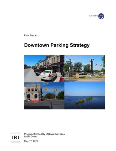
Given the importance of parking, the City of Kawartha Lakes (the “City”) has retained the services of IBI Group to prepare thisDowntown Parking Strategy for thedowntownareas of Lindsay, Fenelon Falls, and Bobcaygeon(the “Core Areas”), a need identified in the City’s Transportation Master Plan for the City’s largest urban centres. Vital to the City’s economic prosperity are these communities’ downtown parking systems, which are utilized by residents, employees and visitors. With that in mind, the objectof the Downtown Parking Strategy is to examine the current state and administration of parking, forecast future parking demand, determine future parking supply needs, and make recommendations accordingly.
It should benoted that the parking utilization surveys informing this study were conducted in 2018 and 2019, prior to the Coronavirus 2019 (COVID-19) pandemic and the transformative effects responses to ithave had on societies and economies. Massive shifts toward working from home coupled with unprecedented forced reductions in economic activityhave doubtless reduced parking demand for 2020-2021. While parking demand is anticipated to rebound as the pandemic abates and moves toward resolution, it is impossible to know at this time what will be the lasting effects of the pandemic on parking demand.
While some users of the CoreArea parking systems may perceive a shortage of parking at certain times, this study shows that, based on industry best practices and utilization data, the existing parking supply is adequate to meet existing demand. Rather than a shortage of supply, existing parking challenges have been found to stem principally from (i) uneven distributionof parking activity,(ii) deficient wayfinding and awareness of the availability of parking and (iii)
DOWNTOWN
restrictive notions of an acceptable walking distance Many of the recommendations made herein are designed to address such issues or take advantage of low-cost expansions to parking supply wherever possible Through to 2041, only the Lindsay Core Area is anticipated to require expansion to parking supply. Fortunately, half of that expansion entails no or minimal added capital cost, primarilybecause it coincides with capital works expected to occur anyhow.
This section summarizes a review of relevant background materials used to inform the Downtown Parking Strategy. The objective of this review is tooutline the broad policy context in which the study is prepared. The following background documents were reviewed:
• Downtown Lindsay and Oak Street HeritageDistrict Conservation Plans (2017);
• Lindsay and Fenelon Falls Downtown Revitalization Action Plans (2017);
• Strategic Community Improvement Plan (2018);
• Community-Specific Zoning By-Laws (2018, 2019);
• Growth Management Strategy (2011);
• Lindsay Transit Master Plan (2018); and
• TransportationMaster Plan (2012).

The Heritage Conservation District (HCD) Plans of both Downtown Lindsay and the Oak Street neighbourhood (located in Fenelon Falls) outline the goals, objectives, policies,guidelines, and processes associated with the conservation of natural and built features of heritage value The plans note that the HCDs are attractive to residents, businesses, and visitors, andthat as the demand for parking increases, there should be policies in placeto provide sufficient parking and access while conserving heritage features Specifically, the plans note the need for parking policies to address demands arising fromnew multiple-dwelling units andto consider theimpacts of new or expanded parking, particularly in front yards. The recommendations of this study are formulated with consideration forthe policies and guiding principles set out by the HCD Plans.

The Lindsay Downtown Revitalization Action Plan outlines the critical issues, opportunities, challenges, necessary actions, priority scheme, and proposed timelines associated with the revitalization of Lindsay’sCore Area. The action plan outlines eight goalsand associated tasks pertaining to economic development, leadership and management, marketing and promotion, and physical improvements, a set of recommendations, and an implementation strategy. One of theaction plan’s goals is to “improve transportation facilities and functionality in the Downtown”. Respecting that goal, the action plan identifies the following parking-related activities:
1
• Identify additional, adequate, available, and properly maintained parking throughout theCore Areato meet increased demands for parking from business owners and patrons;
• Record in the City’s geographic information system (GIS)the location of all currently available parking spaces, including accessible parking spaces, the site of the regional bus pick-up and drop-off location, and the City bus pick-up and drop-off locations;
• Address horse and buggy parking needs in theCore Area, engaging the area Amish and Mennonite communities to determine their needs;
• Consider incorporating “charging stations” for electric cars, scooters, and similarvehicles into the Core Area’s transportation facilities; and
• Identify the needs of active transportation (e.g. bicycling)in the Core Area and provide the facilities, inclusive of parking,necessary to accommodate suchneeds. 1
Similarly, the Fenelon FallsDowntown Revitalization Action Plan outlines nine goals and associated tasks aimed at fostering commercial activity and providing a vibrant and engaging environment for businesses, residents, and visitors. One of the goals withinthat plan is to “support existing and potential businesses to locate and expand in Fenelon Falls” Specific to parking, theaction plan proposes the following activities, among others, pertaining tothis goal:
• Conduct a parking inventory, including quality of parking area, lighting, and signage (including wayfinding signage to access parking);
• Identify parking deficiencies and needs; and
• Eliminate cash-in-lieu of parking.
Recommendations emanating fromthis study take into consideration the goals and activities set out inboth action plans

The City’s Community Improvement Plan (CIP) was prepared to support economic development within several targeted areas of the City, including the Core Areas of Lindsay, Fenelon Falls, and Bobcaygeon. The CIP outlines strategies and programs aimed at promoting revitalization and improvement of private property. Specific to parking, the CIP provides for the following programs:
• Accessibility Improvement – This program is available to assist eligible property owners with the cost of implementing measures to
improve the accessibility of their properties, including accessible parking spaces;
• Design Studies – This program is available to assist eligible property owners with the cost of preparing architectural or engineering plans and site plans for accessibility retrofits or otherproperty improvements; and
• Building Repair andRenovation – This program is available to assist eligible property owners with the costs arising from the conversion, intensification, repair orother improvement of their properties, including the creation of new residential units within existing mixeduse buildings.
Recommendations emanating from this study are consistent with theprograms and visionset out in the CIP.

Below are the Zoning By-Laws (ZBLs) relevant to the Downtown Parking Strategy:
• Town ofLindsay Comprehensive Zoning By-Law 2000-75 (January 2019);
• Village of Fenelon Falls Comprehensive Zoning By-Law 89-25 (June 2018); and
• Village of Bobcaygeon Comprehensive Zoning By-Law 16-78, Office Consolidation (January 2019).
Among other things, the ZBLs establish development-related parking requirements based on land use,regular and accessibleparking space standards, and loading space standards The community-specific ZBLsare an input into the Downtown Parking Strategy.

Based on theprovincial growth plan, the City’s Growth Management Strategy (GMS) lays the groundwork for the planning, servicing and financing of population and employment growth over an extensive planning horizon. In particular, the GMS informs the City’s Official Plan, zoning by-laws, development charges by-law and various service master plans.As one of those master plans, the Downtown Parking Strategy leverages the growth forecast in theGMS and the Provincial Growth Planto estimate anticipated future demand for parking in the Core Areas
Based on the GMS, theLindsay Transit Master Plan provides a framework to guide the growth of the Lindsay transit system to 2027. Objectives of the plan include improving the reliability andaccessibility of transit service, expanding the service area within the City where justified, and identifyingroute network
improvements The plan notesthe potential of a future downtown transportation hub. The recommendations formulated through this study are supportive of the objectives and visionset out by the Lindsay Transit Master Plan.

Based on the GMS, theTransportation MasterPlan determines the City’s growth-related transportation requirements to 2031. The plan identifies numerous growth-related capital needsrelating to expansion of bridge and road capacity (e.g. road widening), signalization and other intersection improvements, and needs forfurther investigation and study (e.g. corridor studies). One of the latter needs identified is that of a Downtown Parking Strategy. The recommendations formulated through this studyare supportive of, or complementary to, the broader transportation needs identified by the Transportation Master Plan.
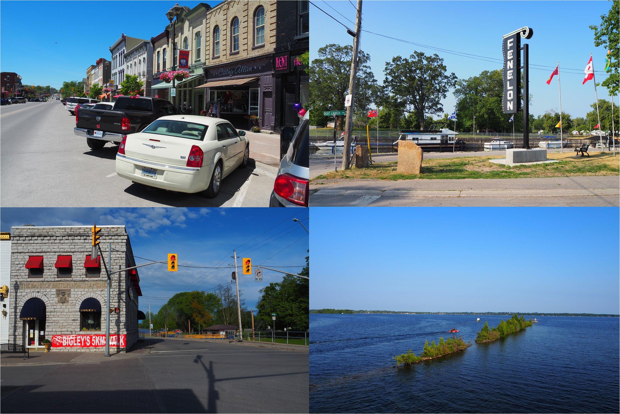
Stakeholder and public consultation for the Downtown Parking Strategy was completed in two phases. The first phase was conducted near the beginning of the study to obtaininformation onexisting parking operations, knowledge of existingparking issues, and desiredor expected study outcomes. The second phase was conducted toward the end of the study to presentthe study’s preliminary findings and recommendations, and obtain feedback from stakeholders and the public prior to finalization ofthe recommendations.

Phase 1of the stakeholder and public consultation planconsisted of the following consultation activities:
• One stakeholder meeting and one Public Information Centre (PIC) in each ofLindsay, Fenelon Falls, and Bobcaygeon; and
• An onlinesurvey and crowd sourcing map.
This section summarizesPhase 1 results.
As part of the consultation plan, IBI Group hostedstakeholder meetings and PICs in Lindsay on March 5, 2019, in Fenelon Falls on March 6, 2019,and in Bobcaygeon on March 7, 2019. In each of the six meetings,attendeeswere encouraged to share their thoughts onexisting parkingoperations, existing parking issues, and desiredor expectedstudy outcomes.
Common themesthat emanated from the stakeholder meetings and PICs were:
• Perception of inadequate parking availability, especially in summer;
• Poor wayfinding signage formunicipal parking lots;
• Unclear long-vehicle parking availability;
• Lack of proactive parking enforcement;
DOWNTOWN
• Lack ofaccessible parking; and
• Inconsistency in approaches to cash-in-lieu of parking.
A questionnaire was prepared and presented to the general public in the form of an online survey, which was active from the beginning of April 2019 tothe end of August2019. The survey resultsprovide asense of general parking behaviour and perceptionsin theCore Areas of Lindsay, Fenelon Falls, and Bobcaygeon.
Exhibit 3-1, Exhibit 3-2, and Exhibit 3-3 summarize indications of public satisfaction with parking in the three Core Areas. Greater detail on the survey results is provided in Appendix A.
Exhibit 3-1: Phase 1 PIC Results – Lindsay Core AreaParking Experience Satisfaction
Exhibit 3-2: Phase 1 PIC Results – Fenelon FallsCore Area Parking Experience Satisfaction
For the Lindsay Core Area, nearly half of those surveyed indicated they were satisfied or neutral about their overall parking experience. For the Fenelon Falls and Bobcaygeon Core Areas, the majority of respondents indicated that they were satisfied or neutral abouttheir overall parking experience.The survey results for Lindsay show that 52% of respondents would like to see a parking garage built in downtown Lindsay and that 51% would not support paid on-street parking. Approximately 84% ofFenelon Falls respondents would not support paid on-street parking in downtown Fenelon Falls Approximately 57% of Bobcaygeon respondents would not support paid on-street parking in downtown Bobcaygeon.
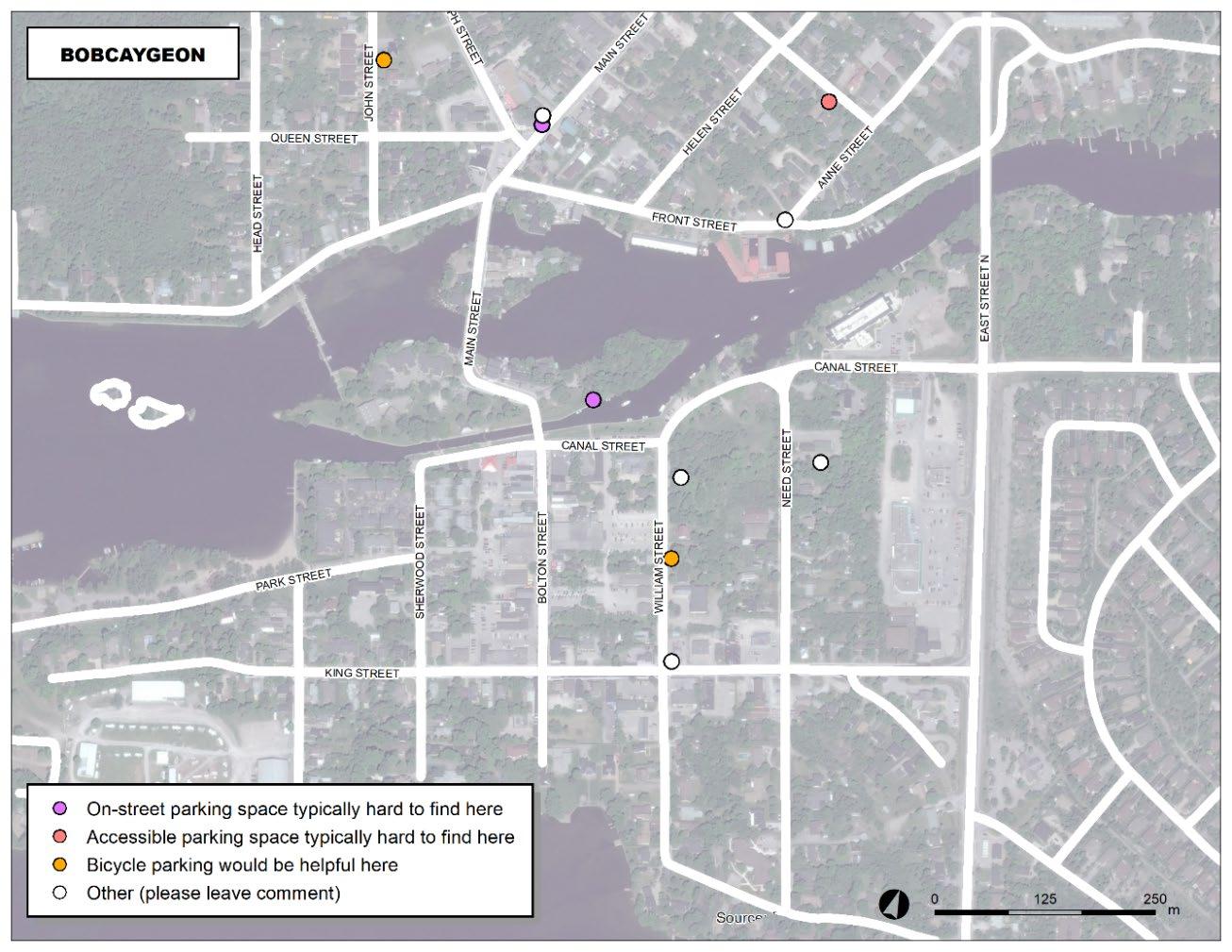
At the end of the online survey, respondents were given access to an interactive online crowd sourcing map to identify precise locations where they have experienced parking-related difficulties. Crowd-sourced information has been aggregated and mapped to provide asense of the nature and locations of various parking issues experienced by respondents, as illustrated in Exhibit 3-4, Exhibit 3-5, and Exhibit 3-6 With sufficient responses,parking “hot spots” were identified.
For Lindsay’s Core Area, many respondents noted they had difficulty finding onstreet parking on Kent Street, between Cambridge Street and William Street. Respondents also identified numerous locations where they wouldlike to see bicycle parking, particularly in close proximity to Kent Street. Moreover, there were several indications of areas perceived as unsafe or inadequately lit near the intersection of York Street / Kent Street, among others.
For the Fenelon Falls Core Area, respondents noted they experienced difficulty finding on-street parking near the intersection of Francis Street West / John
DOWNTOWN
Street. Additionally, it was indicated that bicycle parking was desired along Francis Street West, near the waterfront.
For the Bobcaygeon Core Area,respondents indicatedthey had difficulty finding parking on Canal Street east of its intersection withBolton Street, as well as in the Market Square area (i.e.the intersections of Queen Street / Joseph Street / Main Street and Front Street / Main Street. Respondents also identified several locations across the Core Area where the provision of bicycle parking would be useful.
DOWNTOWN PARKING STRATEGY
Prepared for the City of Kawartha Lakes
DOWNTOWN PARKING STRATEGY
Prepared for the City of Kawartha Lakes
3-5: Fenelon Falls Core Area Crowd Sourcing Map
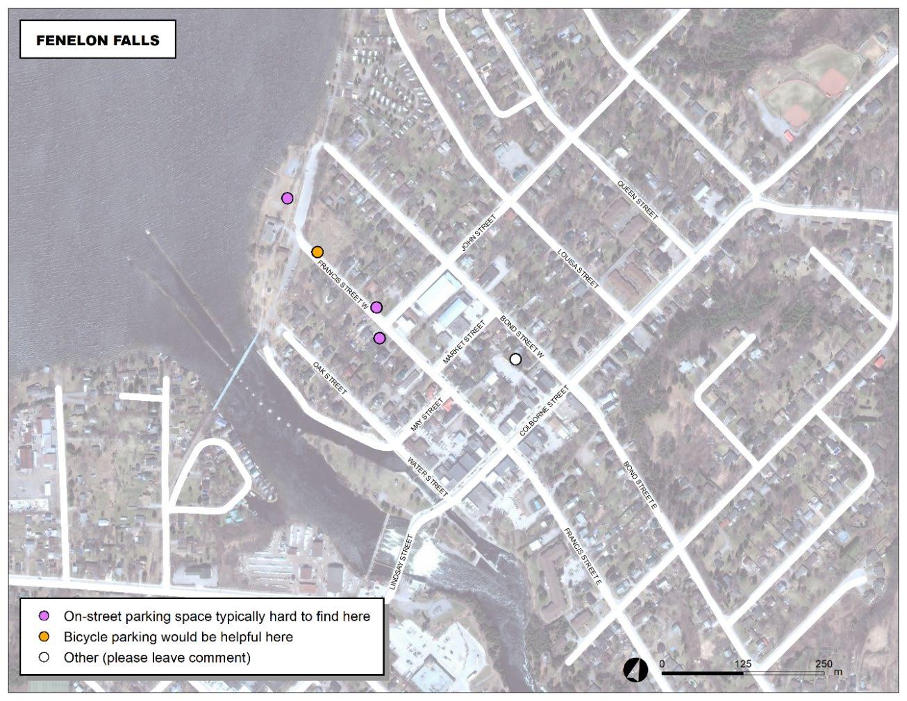
Exhibit 3-6: Bobcaygeon Core Area Crowd Sourcing Map

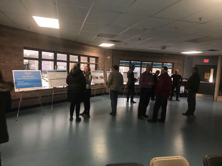
Phase 2 of stakeholder and public consultationconsisted ofa secondround of stakeholder meetings and a second round of PICs,this time to review the preliminary findings and recommendations of the studyand to obtain feedback on them.
IBI Group hosted a second round ofstakeholder meetings and PICs in Lindsay on October 15, 2019, in Fenelon Falls on October 16, 2019, and in Bobcaygeon on October 17, 2019.Similar to the first round, stakeholders and the public provided input regarding the state and operation of theexisting parking system, knowledge of existing parking issues, and desiredor expectedstudy outcomes. Additionally, attendees provided feedback on the study’spreliminary findings and recommendations. The following summarizes the preliminary recommendations discussed at the second round of stakeholder meetings and PICs:
• Lindsay-Specific Preliminary Recommendations:
o Make available to the public off-street parking spaces currently reserved for municipal employees;
o Repave and reconfigure existing parking lots;
o Introduce dynamic or locationalpricing tomore evenly distribute on-street parking utilization;
o Provide proactive enforcement of on-street parking using handheld license plate recognition (LPR) devices to better manage parking duration;
o Add at least one accessible parking space to each of Lots M4, M7, and M11; and
o Maintain free 2-hour on-street parking and monitor implemented recommendations for two years. If parking is not better distributed or managed, consider reinstating on-street paid parking.
• Fenelon Falls-Specific Preliminary Recommendations:
o Repave and reconfigure existing parking lots;
o Convert the former Fenelon Falls Arena lot into a paved and well-configured parking lotwith spaced reserved for long vehicles (e.g. trucks with boat trailers, buses,recreational vehicles etc.);
o Delineate on-street parking along the north side of Oak Street (from May Street to the western limit), and restrict parking on the other side of the street;
o Delineate on-street parking on both sides of Bond Street (from the eastern limit of the study area to just east of the curved segment, adjacent to Garnet Graham Beach Park, to the west);
o Issue parking permits via LPR to Colborne Street residents that have no parking, and allow them to park in Lot M3 with no time restrictions;
o Clean up and add lighting and pavement markings to Lot M3, and enforce encroachmentby-laws etc. prohibiting improper use of the lot;
o Add at least one accessible parking space to eachof Lots M1, M5, M6, and M7; and
o Monitor parking utilization and considerhandheld LPR technology if utilization increases over the next few years.
• Bobcaygeon-Specific Preliminary Recommendations:
o Introduce an on-street parking limit, starting with a 2-hour duration, actively enforced by the City’s Municipal Law
Enforcement Division, and determine if areduction in permitted duration is warrantedin future;
o Monitor parking utilization and consider handheld LPR technology if utilization increases over the next few years;
o Create regular and long-vehicle parkingas part of the redevelopment of Bobcaygeon Beach Park;
o Add at least one accessible parking space to each of Lots M3, M4, and M5;
o Create a long-vehicle route plan and advertise it online; and
o In consultation with theowners of Foodland and by by-law, introduce a time limit at the Foodland parking lot (Lot P2), and deputize Foodland owners and managers to empower them to enforce the parking lot themselvesmore effectively
• General Preliminary Recommendations:
o Make community-specific changes to cash-in-lieu of parking after further consideration;
o Add wayfinding signage;
o Add municipal parking lot locations to Google Maps;
o Create on online parking map for Kawartha Lakes;
o Introduce in-house winter maintenance ofmunicipal lots; and
o Increase parking fines for overtime parking and overnight parking.
The following is a summary ofinput received atthe Lindsay stakeholders meeting:
• If the parking needs of employees were met with a parking garage or pushed to the periphery of the Core Area, then prime parking spaces would bemore available for customers of downtown businesses;
• The Lindsay Downtown Business Improvement Association (“LDBIA”), in partnership with the City, should apply for government grants to fund parking-related capital projects. However, capital planning should not be contingent on grants;
• Dynamic off-street pricing would not resolve congestion of downtown parking facilitiesbecause driversare generally unwilling to park in the Core Area’s peripheryand walkto their destination. Furthermore, the existing LPR devices are inaccurate and there are a lot of problems with the LPR system, so dynamic pricing would only make things worse. New equipment would help;
• Existing parking durations should be monitored, and time limits adjusted according to observed rates of parking turnover;
• Optionsandinformationregarding parking forlong vehicles, such as buses, are inadequate;
• Peripheral parking lots should be better lit and made to feel safer in order to encourage people to park there;
• Rather than build a parking garage, drivers should be induced to more evenly distribute their utilization of downtown parking assets;
• There is a need to incentivize people to park elsewhere rather than build a parking garage;
• If a parking garage is nonetheless what stakeholders and thepublic desire, there are some options tofund it:
o Cash-in-lieu of parking;
o Community benefits charges(replaces development charges);
o LDBIA levy;
o Capital or local improvement charges;
o Paid parking, inclusive of reinstatement of paid on-street parking; and or
o General tax levy.
The majority of stakeholders thought that an LDBIA levy makes sense, but that it could be combined with other financingoptions where appropriate; and
• A well-enforced on-streetparking time limit and improvements to wayfinding signage may prove to be sufficient parking demand managementmeasures.
The following is a summary of the input received at the Fenelon Falls stakeholders meeting:
• Although Fenelon Falls doesnot require more parking overall, the conversion of the former Fenelon Falls Arena lot into a parking lot will provide an opportunity for long-vehicle parking. If the lot is already being paved, regular parking spaces could also be added, and the farmers’ market can continue operating there;
• This parking study is overestimating the projected growth, which is based on the Growth Management Strategy (GMS). Another parking study should be completedin futureto check if the population is growing according tothe projections made in the GMS before implementing any of the major growth-relatedrecommendations made in this study;
• The City shouldconsideradding electric vehicle parking spaces;
• If residential parking permits are introduced to downtownFenelon Falls, Municipal Law Enforcement Division should provide direction to permit holders regarding where to park (based on utilization) and permit holders should be prohibited from parking in Lot M2; and
• The existing cash-in-lieu of parking rateis insufficient to build surface parking, leaving the following options:
o Abolish cash-in-lieu of parking;
o Increase the cash-in-lieu of parking rate to a more appropriate level; or
o Replace cash-in-lieu of parking with development charges or similar charges
The majorityof stakeholders agreed that cash-in-lieu of parking should be eliminated
The following is a summary of theinput received at the Bobcaygeon stakeholders meeting:
• It is not idealfor the Foodland owners to enforce their own parking lot via deputized authority. However, whatever recommendations are made for public parking should also be made for the Foodland parking lot (Lot P2);
• Paid on-street parking should be introduced right away forthe summerseasonso as to generate revenueforproactive enforcement. All revenue frompaid parking should be used exclusively to benefit Bobcaygeon; and
• A three-hour maximum time limit should be introducedfor parking in downtownBobcaygeon, along with paid on-street parking. Both measuresshould be in effect only between Victoria Day and Labour Day long weekends. A two-hour maximum time limit for parking is too restrictive for patrons of downtown Bobcaygeon.
Becausethe Bobcaygeon stakeholder meeting ofOctober 17, 2019 was poorly attended, City staff hosted a supplemental meeting for Bobcaygeon stakeholders on December 4, 2019. The following is a summary of the input received at that meeting:
• That IBI Group’s recommendationsin the Downtown Parking Strategy reflect that:
o Parking assets arecongested only from Victoria Day to Labour Day.
o Approximately 450 homes are planned to be built in Bobcaygeon in the near future.
o The forthcoming island brewery will place considerable pressure on parking assets on Main Street between the canal and Front Street.
o There is an anticipated loss of parking spaces due to Canal Street reconstruction, although there is also an understanding among some stakeholders that, with the reconstruction of Canal Street, Lot M3 will be converted to green space, which will be compensated by an expansion to on-street parkingon Canal Street east of Lot M3 (confirmation from design engineers needed).
o The largest contributor to lack of parking space turnover is abuse of public parking by downtown employees.
o Parking issues differ in intensity across downtown.
• That there is little-to-no support for a time limit for on-street parking given:
o A general desire to not limit the duration of visits to downtown.
o Abuse ofprivate parking is already a significant issue in downtown.
o Limited appetite among business owners to issue parking tickets with deputized authority.
• That some stakeholders see value in keeping in place the defunct parking metres on Main Street because they function as “silent policemen”, encourage some level of turnover (especially among visitors), are low-cost and providethe City with some revenue.
• That a lack of municipal parking supply is placing pressure on private parking lots and that by increasingthis supply the challenges with private parking lots are anticipated to be significantly reduced.
• That the parking lot behind Tim Hortons (southwest corner of Canal Street / East Street intersection) would, if improved, provide an opportunity for long-term and long vehicle parking.
• That a combination of seasonal paid on-street parking, wayfinding signage and parking supplyexpansion is needed.
• That if paid parking is instated, the revenue thereby generated be used exclusively to support local parking services in Bobcaygeon.
• That downtown business owners need to better manage the parking patterns of their employees (e.g. encourage employees to park in public spaces on the periphery or in private parking lots, reserving prime parking for customers).
• Thatseasonally-targeted expansion of off-street public parking supply through leases with businesses, churches etc. with excess private
DOWNTOWN
parking capacity be considered before acquisition of land by the City for the same purpose.
• That the conversion of Main Street parallel parking into angle parking from the dam to Front Street be considered, although this is opposed by a small number of stakeholders whom expressed safety concerns about vehicles reversing into traffic.
• That more and improved wayfinding signage beinstalled to better inform visitors and distribute parking demand.
• That the quantity and distribution of accessible parkingspaces be reviewed and recommendations made accordingly.
• That a form of localized control of parking (e.g. parking authority, LDBIA model etc.) be considered.
This section quantifiesexistingparkingsupply for the Lindsay, Fenelon Falls, and BobcaygeonCore Areas For on-street segments without pavement markings, supplyon each side of the street was estimated by dividing the distance of parking lanesby 7 metres, which is the length of a typical parallel parking space. Areas of parking lanes where parking isnot permitted, such as loading zones or those frontingdriveways orfire hydrants, wereexcluded from that calculation
In the Lindsay Core Area, during 8:30am-4:30pm on weekdays, on-street parking is free for up to two hours and parking at municipal parking lots is free for 2-4 hours depending on the lot Municipal parking lot users who require greater daily parking durations are able to purchase City-issued parking permits for that purpose. In the Fenelon Falls and BobcaygeonCore Areas, on-street and off-street parkingaregenerally restricted to 12 hoursper day unless otherwise posted.
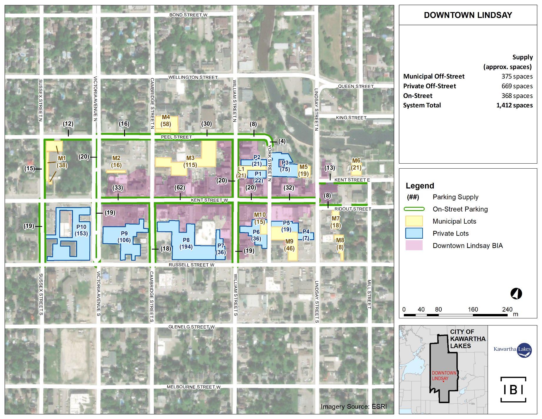
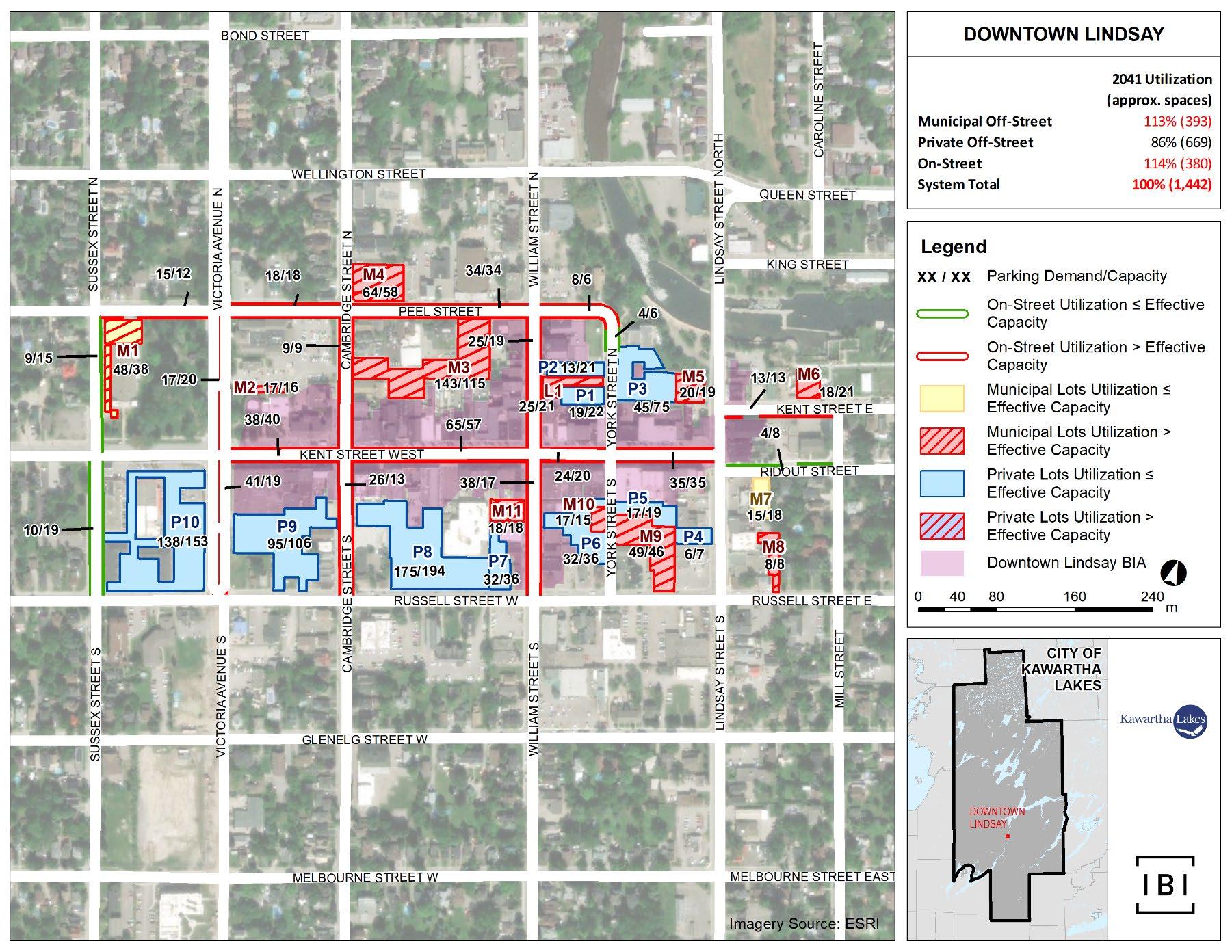
The surveyed LindsayCore Areaparking system consists of 10 private lots,11 municipallotsand 18 on-street segments. Among the municipal lots, one (M1) is theoreticallydedicated to the Victoria Park Armoury, but is still considered available for general public use, and one (L1) is leased by the City from CIBC. The parking spaces in municipal lot M2 that are reserved for municipal vehicles and employees were excluded from the existing parking supply, reducing the surveyed area of that lot to 16 parking spacesgenerally available for public use. Exhibit 4-1 shows a map of the Lindsaystudy area and the parking facilities surveyed therein.Parking supplydata provided by the LDBIAwere utilized to inform this study byenabling data validation and comparisons with historical parking trends.
DOWNTOWN PARKING STRATEGY
Prepared for the City of Kawartha Lakes
DOWNTOWN PARKING STRATEGY
Prepared for the City of Kawartha Lakes
Exhibit 4-2 and Exhibit 4-3 show the surveyed off-street and on-streetparking facilities, respectively, for the Lindsay Core Area.
Exhibit 4-2: Surveyed Lindsay Off-Street Parking Supply
DOWNTOWN
Exhibit 4-3:
Cambridge Street Kent Street to Russell Street 18
Kent Street
Cambridge Street to William Street 62
Kent Street Lindsay Street to Mill Street 13
Kent Street
Victoria Avenue to Cambridge Street 33
Kent Street William Street to York Street 20
Kent Street York Street to Lindsay Street 32
Peel Street
Cambridge Street to William Street 30
Peel Street Sussex Street to Victoria Avenue 12
Peel Street Victoria Avenue to Cambridge Street 16
Peel Street William Street to York Street 8
Ridout Street
Lindsay Street to Mill Street 8
Sussex Street Kent Street to Russell Street 19
Sussex Street Peel Street to Kent Street 15
Victoria Avenue Kent Street to Russell Street 19
Victoria Avenue Peel Street to Kent Street 20
William Street
Kent Street to Russell Street 19
William Street Peel Street to Kent Street 20
York Street Peel Street to Kent Street 4 Lindsay
*Note: The parking supply shown in Exhibit 4-3 does not reflect parking restrictions that may occur throughout the day.
As shown in Exhibit 4-2 and Exhibit 4-3, the Lindsay Core Areaparking supply is comprised of approximately669 private off-street spaces, 375 municipal offstreet spaces and 368 on-street spaces, for a total of 1,412spaces.
The surveyed Fenelon FallsCore Area parking system consists of 6 private lots, 7 municipal lots, and 15 on-street parkingsegments. Exhibit 4-4 shows a map of the Fenelon Fallsstudy area and the parking facilities surveyed therein
DOWNTOWN PARKING STRATEGY
Prepared for the City of Kawartha Lakes
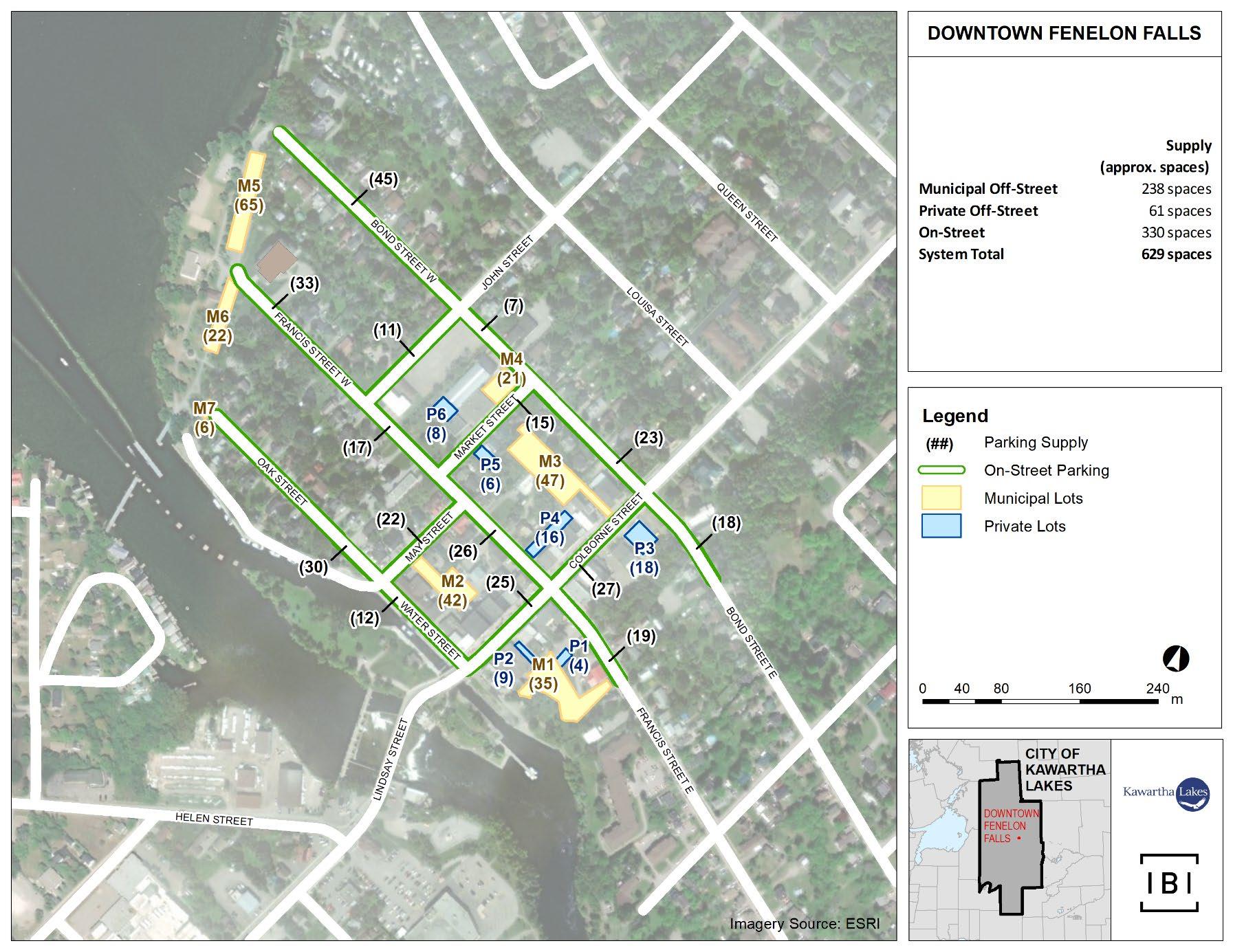
Exhibit 4-5 and Exhibit 4-6 show the surveyed off-street and on-streetparking facilities, respectively, for the Fenelon Falls Core Area.
Exhibit 4-5: Surveyed Fenelon Falls Off-Street Parking Supply
Exhibit 4-6: Surveyed Fenelon Falls On-Street Parking Supply
Bond Street Colborne Street to 100m east of Colborne Street 18
Bond Street John Street to Market Street 7
Bond Street Market Street to Colborne Street 23 Bond Street West End of Street to John Street 45
Colborne Street Bond Street to Francis Street 27
Colborne Street Francis Street to Water Street 25
Francis Street Colborne Street to 100m east of Colborne Street 19
Francis Street John Street to Market Street 17
Francis Street Market Street to Colborne Street 26
Francis Street West End of Street to John Street 33 John Street Bond Street to Francis Street 11
Market Street Bond Street to Francis Street 15 May Street Francis Street to Water Street/Oak Street 22 Oak Street West End of Street to May Street 30 Water Street May Street to Colborne Street 12 Fenelon Falls On-Street Total 330
*Note: The parking supply shown in Exhibit 4-6 does not reflect parking restrictions that may occur throughout the day.
DOWNTOWN
As shown in Exhibit 4-5 and Exhibit 4-6 the Fenelon FallsCore Area parking supply is comprised of 61 private off-street spaces, 238municipal off-street spaces and 330 on-street spaces, for a total of 629spaces.
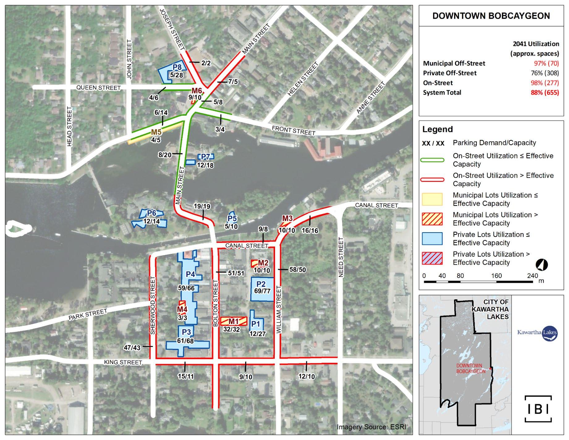
The surveyed Bobcaygeon Core Area parking system consists of 8 private lots, 6 municipal lots, and 15 on-street segments. Exhibit 4-7 shows a map of the Bobcaygeon study area and the parking facilities surveyed therein.
DOWNTOWN PARKING STRATEGY
4-7: Bobcaygeon Core Area ParkingSupplyMap
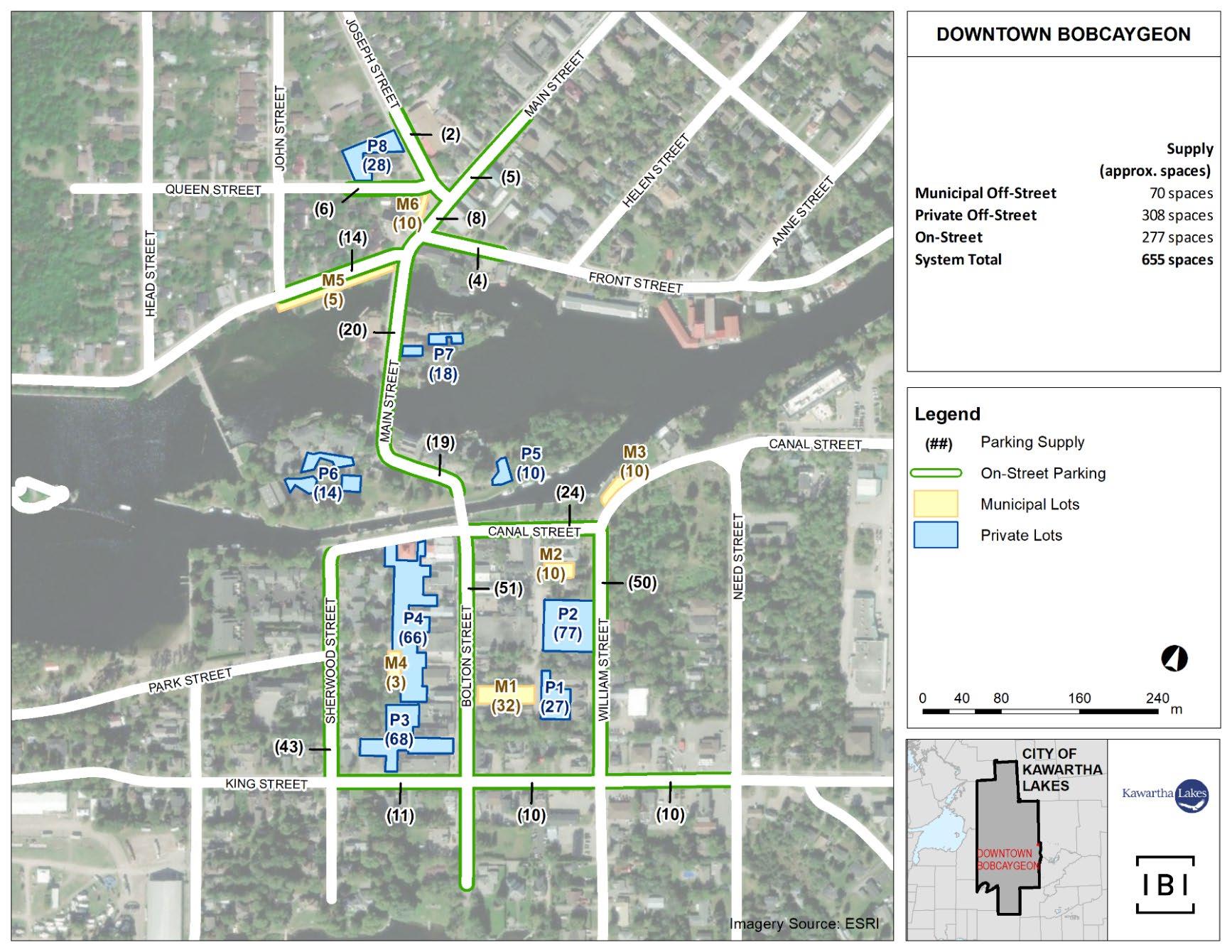
Exhibit 4-8 and Exhibit 4-9 show the surveyed off-street and on-streetparking facilities, respectively, for the Bobcaygeon Core Area.
Exhibit 4-8: Surveyed Bobcaygeon Off-Street ParkingSupply
Exhibit 4-9: Surveyed Bobcaygeon On-Street Parking Supply
*Note: The parking supply shown in Exhibit
As shown in Exhibit 4-8 and Exhibit 4-9, the BobcaygeonCore Area parking supply is comprised of 308 private off-street spaces, 70 municipal off-street spaces and 277 on-street spaces, for a total of 655 spaces.
This section estimates existing parking utilization for the three Core Areas, and highlights parking facilities for which utilization is approachingor exceeding effectivecapacity. The term “effectivecapacity” refers to thethreshold rate of peak utilization at which a parking facility is, on a service level basis, considered fully consumed.In other words, effective capacity defines the peak rate of utilization of total capacity beyond which excessivecongestion of parking facilities occurs from a service level standpoint. Based on industry best practices and generally acceptable service standards, effective capacity is defined herein as 85%and 90%of total capacity for municipal and private parking facilities, respectively. Based on its mix of municipal and private parking, a downtown parking system will therefore have an effective capacity between 85% and 90% of its total capacity. Once peak system-wideutilization exceeds this threshold, users typically experience excessive difficultywith finding available parking.
Parking utilization surveys of the Core Areas wereconductedduringvarious seasons, days and timesto capture utilization rates of on-street and off-street parking facilities.Survey data were collected on an hourly basis at all three Core Areas during the following daysand times:
• Tuesday, December 18, 2018: 7:30 AM to 4:30 PM (Winter);
• Saturday, December 22, 2018: 10:00 AM to6:00 PM (Winter);
• Tuesday, June 4, 2019: 7:30 AM to 4:30 PM (Spring);
• Wednesday, June 5, 2019: 7:30 AM to 4:30 PM (Spring);
• Saturday, June 8, 2019: 10:00 AM to 6:00 PM (Spring);
• Wednesday July 25, 2019: 7:30 AM to 4:30 PM (Summer); and
• Friday July 27, 2019: 10:00 AM to 6:00 PM (Summer)
The utilization data are disaggregated by parking facility in Appendix B As the surveys occurred in winter, spring and summer, and on weekdays and weekends, the utilization data collectedareconsideredtohavecaptured temporal fluctuations in parking demand without adjustment.In keeping with standard evaluative practiceand to promote a conservative approach herein, observed peak demandfor each Core Area is used for demand-supply assessment purposes.
DOWNTOWN
Hourly system-wide parking utilization trendswithin the Lindsay Core Area for the winter2018, spring 2019, and summer2019 survey periods are illustrated in Exhibit 4-10, Exhibit 4-11, and Exhibit 4-12
Exhibit 4-10: Lindsay Core Area System-Wide Parking Utilization (Winter 2018)
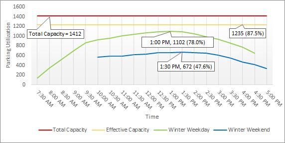
Exhibit 4-11: LindsayCore Area System-Wide Parking Utilization (Spring 2019)
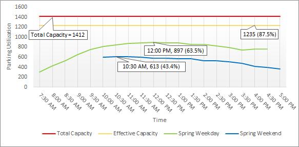
Exhibit 4-12: LindsayCore Area System-Wide Parking Utilization (Summer 2019)
Notableobservationsemanating from the Lindsay surveys include:
• Weekday utilization was consistently higher system-wide compared to weekend utilization;
• During weekdays, the winter season had the highest overall parking utilization (78.0% occupied), followed by summer (69.0%), and spring (63.5%);
• During weekends,the winter season had the highest overall parking utilization (47.6% occupied),followed by spring and summer (43.4% and 43.1%, respectively);
• The weekday peak time for the winter, spring, and summer seasons occurred at 1:00 PM, 12:00 PM, and 12:00 PM, respectively;
• The weekend peak time for the winter, spring, and summer seasons occurred at 1:30 PM, 10:30 AM, and11:30 AM, respectively; and
• While system-wide utilization remained below effective capacity at all times, utilization of particular lots and street segments was observed to exceed effective capacity for periods of time.
Exhibit 4-13 showshighest-observed peak-hour utilization by parking facility within the Lindsay Core Area.
DOWNTOWN PARKING STRATEGY
Prepared for the City of Kawartha Lakes
Exhibit 4-13: Lindsay Core Area| Peak-Hour Utilization Map (1:00 PM to 2:00 PM)
May 17, 2021
Basedon Exhibit 4-13, the following conclusions can be drawn aboutpeak-hour utilization of parking facilitieswithin the Lindsay Core Area:
• The system of municipal lots essentiallyoperates at effective capacity. The majority of municipal lots with utilization exceeding effective capacity are located in close proximity to the intersection of William Street / Kent Street;
• Several private lots operate below effective capacity; and
• The majority of street segmentsoperateabove effective capacity, although the on-street parking system operates below.
Based on the utilization survey results, it is concluded that, as a parking system, the Lindsay Core Area currently operates below effective capacity, and that a number of parking facilitieswithin an acceptable walking distance to downtown destinations areevidentlyunderutilized. Therefore, the existing parking system is considered sufficient to meet existing parking demand.
Hourly system-wide parking utilization trends within the Fenelon Falls Core Area for the winter 2018, spring 2019, and summer 2019 survey periods are illustrated in Exhibit 4-14, Exhibit 4-15, and Exhibit 4-16
Exhibit 4-14: Fenelon FallsCore Area System-Wide Parking Utilization (Winter 2018)
DOWNTOWN PARKING STRATEGY
Prepared for the City of Kawartha Lakes
Exhibit 4-15: Fenelon FallsCore Area System-Wide Parking Utilization (Spring 2019)

May 17, 2021
May 17, 2021
Exhibit 4-16: Fenelon FallsCore Area System-Wide Parking Utilization (Summer 2019)
Notable observations from the Fenelon Falls surveys include:
• Weekday and weekendutilization patterns were similarin winter and summer (43% ± 1%);
• During weekends, the spring season had the highest overall utilization (50.4%), followed by summer (43.4%), and winter (42.6%);
• Weekend peak utilization for the winter, spring, and summer seasons occurred at 11:30 AM, 1:30 PM, and 12:00 PM, respectively; and
• While system-wide utilization remained below effective capacity at all times, utilization of particular lots was observed to exceed effective capacity for periods of time
Exhibit 4-17 shows highest-observed peak-hour utilization by parking facility within the Fenelon FallsCore Area.
DOWNTOWN PARKING STRATEGY
Prepared for the City of Kawartha Lakes
Exhibit 4-17: Fenelon Falls Core Area | Peak-Hour Utilization Map (1:30 PM to 2:30 PM)
DOWNTOWN
Basedon Exhibit 4-17, the following conclusions can be drawn aboutpeak-hour utilization of parking facilities within the Fenelon Falls Core Area:
• Municipal lots operate well below effective capacity with the exception of Lot M2 and Lot M7;
• Lot P1 and Lot P2 operate at totalcapacity,however, Lot M1, which is adjacent to these private lots, operates well below effective capacity; and
• On-street segments operate well below effectivecapacity.
Based on the utilization survey results, the existing parking supply in the Fenelon FallsCore Area is considerably more thansufficient to accommodate existing parking demand.
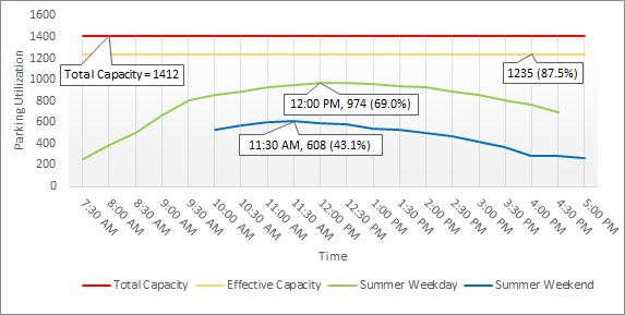
Hourly system-wide parking utilization trends within the BobcaygeonCoreArea for the winter 2018, spring 2019, and summer 2019 survey periods are illustrated in Exhibit 4-18, Exhibit 4-19, and Exhibit 4-20
DOWNTOWN
Exhibit 4-18: BobcaygeonCore Area System-Wide Parking Utilization (Winter 2018)
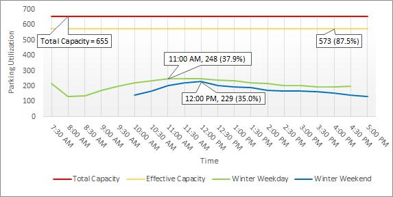
Exhibit 4-19: BobcaygeonCore Area System-Wide Parking Utilization (Spring 2019)
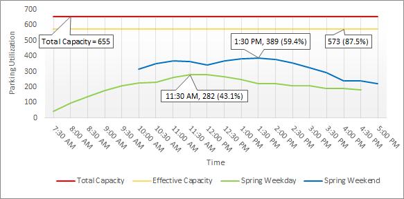
Exhibit 4-20: BobcaygeonCore Area System-Wide Parking Utilization (Summer2019)
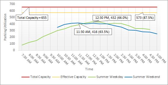
Notableobservations from the Bobcaygeon surveysinclude:
• Compared to weekends, weekday system-wide utilization was slightly higher during the winter, slightly lower during the spring, and was approximately equal during the summer;
• During weekdays, the summer seasonshowcased the highest utilization (66.0%), followed by spring (43.1%) and winter (37.9%);
• During weekends,the summer seasonshowcased the highest utilization (63.5%), followed by spring (59.4%) and winter (35.0%);
• Weekday peak utilization for the winter, spring, and summer seasons occurred at 11:00 AM, 11:30 AM, and 12:30 PM, respectively;
• Weekend peak utilization for the winter, spring, and summer seasons occurred at 12:00 PM, 1:30 PM, and 11:30 AM, respectively; and
• While system-wide utilization remained below effective capacity at all times, utilization of particular lots and street segments was observed to exceed effective capacity for periods of time
Exhibit 4-21 shows highest-observed peak-hour utilizationby parking facility within the BobcaygeonCore Area.
DOWNTOWN PARKING STRATEGY
Prepared for the City of Kawartha Lakes
Exhibit 4-21: Bobcaygeon Core Area | Peak Weekday Utilization Map (12:30 PM to 1:30 PM)
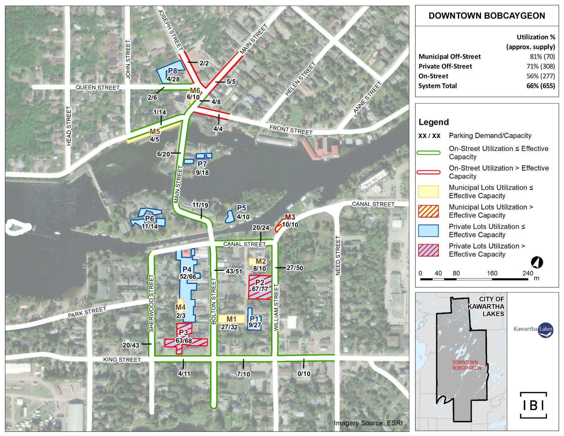
Based on Exhibit 4-21, the following conclusions can be drawn aboutpeakhour utilizationof parking facilitieswithin the Bobcaygeon Core Area:
• Private parking lots P2 and P3 and municipal lot M3 operate above effective capacity, while all other parking lotsoperate below;
• Demand for on-street parking is relatively highin the Market Square area, notably forJoseph Street, Main Streetand Front Street East
Based on the utilization survey results, the existing parking supply in the Bobcaygeon Core Area is sufficient to accommodate existing parking demand.
Based on the foregoing observations andfindings, the following conclusions are drawnabout existing parking supply and demand:
• The Lindsay Core Areaparking systemoperates with a peak utilization of 78%, with said peak occurring at 1:00 PM during the winter weekday. The systemof municipal lots essentially operates at effective capacity. The majority of municipal lots with utilization exceeding effective capacity are located in close proximity to the intersection of William Street / Kent Street. The system of on-street parkingoperates below effective capacity, although a number of segments operate above.Excess capacity in private parking lots and underutilization of peripheral on-street parking are such that system-wide peak utilizationin downtown Lindsayis below effective capacity.
• The Fenelon FallsCore Areaparking systemoperates with a peak utilization of 50%, with said peak occurring at 1:30 PM during the springweekend. While some municipal and private lots operateat or near total capacity, parking opportunities are available nearby.
• The Bobcaygeon Core Areaparking system operates with a peak utilization of 66%,with said peak occurring at 12:30 PM during the summerweekday. While some municipal and private lots operate at or neartotal capacity, parking opportunities are available nearby
For each of the Core Areas, and on a system-wide basis, existing parking supply is sufficient, in some cases significantly more than sufficient, to accommodate existing parking demand.
Through on-site inspections and informed by asset data provided by the City, IBI Group conductedcondition assessments of the City’s off-street parking facilities within the Core Areas.This exercise includes decomposing facilities into component assets, evaluating asset condition, estimating asset replacement timing and costs and developing recommendations relating to maintenance and capital improvements. This section highlights the recommendations emanating from thatexercise; the fullset of results is contained in the Municipal Parking Lot Asset Registry, which is Appendix C to this study
Population of theMunicipal Parking Lot Asset Registrywas informed by a combination of sources:data provided by the City, online research and field data collectionthrough on-site inspections. For each asset, the in-service year was estimatedusingjudgement based ona comparison ofobserved condition to expected service life. Assets observed to have failed were recommended for replacement, while assets observed to still be serviceable but in need of repair were recommended for maintenance.

IBI Group collected field data on Tuesday, July 30, 2019 in Bobcaygeon and Fenelon Falls, and on Wednesday, July 31, 2019 in Lindsay, where data on the following itemswas collected:
• Type of asset: pavement, lighting,storm sewers (catch basins), signs, and railings;
• Quantity: unit dependent on the asset;
• Condition rating: Scores of 1 through 10 were used, with 1 representing a new asset and 10 representing an asset that has failed; and
• Additional notes.
Exhibit 5-1, Exhibit 5-2, and Exhibit 5-3 summarize the asset condition assessment findings and recommendations for Lindsay, Bobcaygeon, and Fenelon Falls, respectively.
Exhibit 5-1: Lindsay AssetCondition Assessment Findings
Crack seal where appropriate, and consider patching around the northern catch basin.
Repaint pavement immediately including delineation and accessible parking spaces.
Patch asphalt in targeted areas where needed.
During patching, correct for identified drainage issue around catch basins.
Straighten poles and replace accessible parking signs with paint beginning to fade. Consider accessible signs similar to Lot M5.
Repaint pavement as the paint continues to fade.
seal and patch in localized areas where appropriate. Sweep the snow melt debris.
Restore the Lot's northern connection with Peel Street after construction is complete.
Repaint pavement as the paint continues to fade.
Replace the accessible parking signs that are missing. Consider accessible signs similar to Lot M5.
Repave after Peel Street road construction is complete.
Implement the appropriate amount of accessible parking spaces with pavement paint and signage identification.
Straighten parking signs, consider standalone signs to be similar to the accessible signs in Lot M5.
Storm Sewer 1
The garbage bins at the northeast corner of the parking are impedingparking supply. Relocate the bins to a location in the parking lot that will not impede parking supply.
Potential pooling observed around the catch basin indicating drainage problems. City should follow-up after a rain fall and correct as necessary.
Add parking information signs similar to the other municipal lots.
Install accessible parking signs at the accessible spaces. Consider accessible signs similarto Lot M5.
Straighten the bent parking information sign.
Implement the appropriate amount of accessible parking spaces with pavement paint and signage identification.
Lot M7 and M8.
asphalt pavement. Delineate parking spaces.
Implement the appropriate amount of accessible parking spaces with pavement paintand signage identification. Consider combining Lot M7 and M8.
Restore the Lot's southern connection once the Russel Street construction is complete. Straighten the bentinformation sign.
pavement as the paint continues to fade.
Install accessible parking signs at the accessible spaces. Consider accessible signs similar to Lot M5.
Consider installing asphalt pavement with parking spaces delineated.
Implement the appropriate amount of accessible parking spaces with pavement paint and signage identification.
Storm Sewer 1
L1
Repaint pavement as the paint continues to fade. Relocate the two parking information signs blocked by the flowers.
Install accessible parking signs at the two accessible spaces. Consider accessible signs similar to Lot M5.
*Scoring Range = 1 (new asset) to 10 (an asset that has failed)
Storm Sewer N/A
3
M1
Storm Sewer N/A
M2
M3
M4
Storm Sewer N/A
3
4
N/A
2
Storm Sewer 4
N/A
3
N/A
N/A
Storm Sewer N/A
3
M5
3
N/A
Sweep the snow melt debris.
Crack seal and patching in localized areas where appropriate. Potentially resurface asphalt pavement depending on observed condition after snow melt debris are swept.
Repaint pavement as the paint continues to fade. Straighten the two 3 hour limit parking signs.
Consider installing asphalt pavement with parking spaces delineated.
Implement the appropriate amount of accessible parking spaces with pavement paint and signage identification.
Consider installing asphalt pavement with parking spaces delineated.
Implement the appropriate amount of accessible parking spaces with pavement paint and signage identification.
Straighten the eastern No Parking sign's pole.
Consider installing asphalt pavement with parking spaces delineated.
Implement the appropriate amount of accessible parking spaces with pavement paint and signage identification.
Consider installing asphalt pavement with parking spaces delineated.
Signage N/A
Storm Sewer N/A
Implement the appropriate amount of accessible parking spaces with pavement paint and signage identification. M6
N/A
Replace the no parking between 11 PM and 7 AM signs as they deteriorate.
Install an accessible parking sign at the accessible space.
*Scoring Range = 1 (new asset) to 10 (an asset that has failed)
Storm Sewer N/A
Repave asphalt pavement.
Straighten the 2 hour limit parking sign.
Implement the appropriateamount of accessible parking spaces with pavement paint and signage identification.
Storm Sewer N/A
Sweep the snow melt debris.
Crack seal in localized areas where appropriate.
Repaint pavement as the paint continues to fade.
Sweep the snow melt debris.
Crack seal and patch in localized areas where appropriate.
Potentially resurface asphalt pavement depending on observed condition after snow meltdebris is swept. Consider repaving western limit of Lot M2 regardless.
Potentially repaint delineation following parking lot sweep depending on observed conditions.
Install an accessible parking sign at the accessible space, and reapply pavement paint.
Storm Sewer 3 Sweep the snow melt debris.
M5
M6
Surface 3
ASSET CONDITION RATING
N/A
2
2
Storm Sewer N/A
N/A
4
N/A
N/A
Storm Sewer N/A
N/A
3
N/A
N/A
Storm Sewer N/A
2
M7
M8
3
N/A Signage N/A
Storm Sewer N/A
2
3
N/A Signage N/A
Crack seal in localized areas where appropriate. Repaint pavement as the paint continues to fade.
Consider installing asphalt pavement with parking spaces delineated.
Implement the appropriate amount of accessible parking spaces with pavement paint and signage identification.
Repaint the parking delineation.
Implement the appropriate amount of accessible parking spaces with pavement paint and signage identification.
Repaint the parking delineation.
Implement the appropriate amount of accessible parking spaces with pavement paint and signage identification.
Repaint pavement as the paint continues to fade. Install an accessible parking sign at the accessible parking space.
*Scoring Range = 1 (new asset) to 10 (an asset that has failed)
While existing parking supplies in the Lindsay, Fenelon Falls, and Bobcaygeon Core Areas are sufficient to accommodate existing parking demand, each of theCore Areas is anticipated to experience growth in parking demandas well as changes in parking supply as aresult of committed City initiatives. Long-term planning is required to ensurethe sufficiency of downtown parking suppliesinto the future. To that end,this section conducts a future parking assessment that estimates future parking demand and correspondingsupply needs to 2041 by examining:
• Parking demand growth due to anticipatedpopulationgrowth, visitor growth and downtown areadevelopment;
• Changes in parking demand due to anticipated changes in transportation modal split; and
• Anticipated parking demand and supplychanges as a result of committed (i.e. ongoing,planned or recently completed) capital projects or relocations of City offices.
That examination is used toforecast2041 parking utilization for each of the Core Areasas it notionally would be if nothing else is doneby the City to influence parking demand orchange parking supply Recommendations regarding parking demand management(e.g. redistribution of parking patterns) and parking supply expansion are then developed with the aim of ensuring that future parking demand in the Core Areas is ultimately met by adequate parking supply
Thedemand for parking in the City’s downtown areas is expected to increase through the following growth-relatedchannels:
• Anticipated growth in the City’s permanent and seasonal populations;
• Anticipated growth in the City’s volume of visitors as a result of regional and provincial population growth; and
• Anticipated growth in downtown economic activity (e.g. employment) and residentialdwellingunits as a result of development, including conversion of use,of property in and on the periphery of the Core Areas.
IBI Group consulted the 2019 Provincial Growth Plan (to 2051), the City’s Growth Management Strategy (to 2031) and City staff to determine how each of these channels is expected to contribute to parking demand growth. With the City’s forecasted rate of population growth being comparable to the provincial average over the next 30 years, visitor-based parking demand in the City is expected to grow similarly to the City’s population. Likewise, based on the vison of the City’s Strategic Community Improvement Plan and known development plans, development in the Core Areas is anticipated to mirror
that of the City as a whole.These findings suggest that the demand for parking in the Core Areas can be expected to grow at a rate comparable to that of the City’s population.
With that approach taken,and based on the Provincial Growth Plan and the City’s Growth Management Strategy, Exhibit 6-1 summarizes the City’s population forecast to 2041 The City’s Development Charges Background Study accounts for differences in demand for municipal services between permanent and seasonal residents: As compared to a permanent resident, a seasonalresident is deemed to generate half the demand on municipal services. The same adjustment is adopted herein in order to estimate the total increase in parking demand arising from anticipated population growth.
As shown in Exhibit 6-1, thedemand for parking is expected to grow by 32.5% between 2019 and 2041.Accordingly, agrowth factor 1.325 was applied to all parking observations described in Section 4.2 on a lot-by-lot and segment-by-segmentbasis to forecast parking demand as it will be in 2041 without redistribution. The City should, however,monitor actual population growth over time,and adjust the parking demand forecast accordingly.
The Lindsay Transit Master Plan indicates that a number of expansionary transit improvements are expected by 2027, including additional transit routes in Lindsay, extended service on weekday evenings, and serviceextension to Bobcaygeon. Some of these have already been implemented, at least partially.
Historically, for every 1% in population growth, Lindsay Transit ridership has grown by 3%, according to the Lindsay Transit Master Plan. Moreover, improvements to the City’s walking and cycling infrastructure (e.g. trails, bicycle corrals etc.) will make non-automobile modesof transportation more efficient and more attractive to residents and visitors. Such improvements and related recommendationslie outside the scope of this study, but they will be
2 2019 permanent population determined based on a 1.41% compounded annual growth rate, 2016-2041.
3 2019and 2041 seasonal population determined based on a 0.69% compoundedannual growth rate, 2016-2031. Note: data was only available to 2031, so it was assumed that the same growth rate (compounded annually) would apply to 2041.
examined in the City’sforthcoming Active Transportation Master Plan and Forestry and Trails Master Plan.
While existing parkingusers are expected to shift somewhat toward nonautomobile means of travel, the resulting reduction in parking demand is likely to be offsetby an increase in parking demand byprospective users whose demand for parking is currently latent because theyperceive that parking is insufficiently available in the Core Areas. In the absence of detailed information on the latent demand, and with the shift to non-automobile travel expected to be minor, it is assumedherein that thechanges in parking demand arising from the anticipated increase in the non-automobile mode share and the resulting conversion of latent parking demand into active demandoffset one another.
Based on discussions with City staff and agents(e.g. design engineers), IBI Group understands that ongoing, planned and recently completed capital projects and City staff relocations haveimpacted or will impact municipal parking demand or supplyin the Core Areas.
As of the time of writing, the only known committed change to parking demand is that relating to the 2020relocation of the City’s MunicipalLaw Enforcement Division to outside of the Lindsay Core Area, which is estimated to reduce parking demand in that area by 10 spaces (this notionallyreduces2019peak demand for municipal off-street parking from 312to302spaces, prior to application of growth). While the administrative offices for the City’s Department of Engineering and Corporate Assets and Department of Public Works also relocated to outside of the Lindsay Core Area in 2020, thatmove is not expected to change long-term parking demand because, unlike with the Municipal Law Enforcement Division, the premises thereby vacated are expected to be reoccupiedby new tenants with comparable demands for parking in the Lindsay Core Area.
Based on information known as of the time of writing, anticipated committed changes to parking supply aredocumented in Exhibit 6-2. As shown in Exhibit 6-2, 30 parking spaces are expected to be gained in Lindsay, 6 parking spaces are expected tobe lost in Fenelon Falls and no change to parking system capacityis expected for Bobcaygeon.
For thepurpose of the future needs assessment, parking demands and supplies in the Core Areas are adjusted to account for the foregoing changes, given they are committedand largely ongoing.
Exhibit 6-2:AnticipatedMunicipal Parking Supply Changes Dueto Committed Capital Projects
Street (between Kent Street and Peel Street)
Cambridge Street (between Russell Street and Kent Street)
William Street (between Kent Street and Peel Street)
William Street (between Russell Street and Kent Street)
(between Victoria Avenue and Cambridge Street)
(between Cambridge Street and William Street)
Street (between William Street and York Street)
Street (between Peel Street and Kent Street)
Kent Street (between Victoria Avenue and Cambridge Street)
Kent Street (between Cambridge Street and William Street)
Kent Street (between York Street and Lindsay Street)
Vacant Lot at 7 William StreetSouth (identified as M11 in Exhibit 6-7)
Francis Street (between Colborne Street and 100m east of Colborne Street)
Canal Street (between William Street and Need Street)
Canal Street (between Bolton Street and William Street)
Bobcaygeon
Canal Street
Reconstruction 16
Canal Street Reconstruction (16)
Total for Bobcaygeon 0
Based on forecasted parking demand and existing parking supply, as adjusted for the committed parking demand andsupply changes noted in the previous section, this section forecasts 2041 peak parking utilization as it would notionally be if the City did nothing further to manage parking demand or expand parking supply.Existing 2019 and notionalforecasted 2041 peak utilization are summarized in Exhibit 6-3 by Core Area and parking type.
Exhibit 6-3: Existing and Notional Forecasted Peak Utilization
The distance travellers are willing to park from their destination varies depending on the type of destination and the type of parking facility. Research Core Area Parking Type Existing (2019)
By 2041, system-wide peak utilization is forecasted to reach total capacity in Lindsayand effective capacity in Bobcaygeon.Moreover, by 2027-2028, system-wide peak utilization is forecasted to reach effective
in Lindsay. Owing to its substantial
Fenelon Fallsparking system is forecasted to continueoperating wellbelow effective capacitythrough to 2041.
by Mary S. Smith, Thomas A. Butcher, and the Victoria Transport Policy Institute suggests the maximum walking distances presented in Exhibit 6-4 for the corresponding land uses in Exhibit 6-5, where LOS = Level of Service
Exhibit 6-4: Maximum Walking Distance
Exhibit 6-5: Walking Distance Targets
As suggestedby Exhibit 6-4 and Exhibit 6-5, and considering that an average person walks at a rate of about 100m per minute, an average walking distance of 240m to 360m is consideredgenerallyappropriate for the types of parking facilities and establishmentscommonly found inthe Core Areas However, based on the results of the online survey, a maximum walking distance of 300m seems to be preferred in Kawartha Lakes. This distancewas used in identifying opportunities to distribute parking demand more evenly throughout the Core Area parking systems. Nonetheless, provided that accessible parking is adequate and optimally located, a maximum (not average) walking distance of 400m is still considered generally appropriate for each of the Core Areas.
The parking demand redistribution exercise also accounts for the interaction, particularly the substitutability, between private and municipal parking. Through to 2041, parking demandand the density of economic activityin the Core Areas is forecasted to remain too low to justify the introduction of private or municipal parking structures, whetherabove or below ground.With land in
fixed supply, existing and newdevelopment in the Core Areas arenot expected to provide on-site the added parking supplyrequired tomeet the corresponding added demand. Indeed, the City’s experience is that proponentsof development in the Core Areas routinely request relief from private parking provision requirements in zoning by-laws, and thatsuch requests are routinely granted by the City.
Without a compelling reason toexpect otherwise, therefore, excess demand for private parking can be expected to eventually spill over to municipal parking assetsso as to maintain users’ indifference between private and municipal parking. With the supply of private parking expected to remain fixed through to 2041, the parking demand redistribution exercise shifts excess private parking demand to municipal parking assets. This redistribution is done so as tokeep peak utilization of private parking within effective capacity (90% of total capacity), leaving the recommendations hereinregarding parking demand management and supply expansion to address the resulting excess demand placed on municipal parking assets.
Considering the forecasted parking demand increases presented in Section 6.1, acceptable walking distances and expected fixity of private parking supply, parking demand was redistributed as summarized in Exhibit 6-6. Note that this redistribution is strictly a notional exercise to evaluate the sufficiency of parking supply Using the post-redistribution figures in Exhibit 6-6 as a starting point, the following sections outline recommendations aimed at balancing parking demand and supply in each of the three Core Areas through to 2041.
Exhibit 6-7 shows notional forecasted peak utiliztionfor the Lindsay Core Area, after parking demand redistribution. The parking system is anticipated to require a reduction in demand or an increase in supply, or some combination thereof, equal to approximately 221 parking spaces to keep peak utilization below effective capacity(85% for municipal parking, 90% for private parking and 87% for the entire parking system). Accordingly, the following solutions are recommended:
• Upon relocation of the administrative offices for the Paramedic Service from 4 Victoria Ave. N., convert into public municipal parking (10 regular spaces and 1 accessible space) the 11 spaces in Lot M2 currently reserved forParamedic Service vehicles and staff;
• Reconfigure Lot M5to increase parking supply by approximately 10 spaces 4;
• Upon reconstruction or resurfacing of Victoria Ave. from Kent St. to Peel St., widen the street,close the entrance to Lot M2 and convert the parallel parking into angle parking to increaseparking supply by approximately34 spaces (from 20 to 54spaces);
• Upon reconstruction or resurfacing of Kent St. from Victoria Ave. to Sussex St., widen the street andextend angle parking from Victoria Ave. to Sussex St., making allowance for turning lanes as needed, to increase parking supply by approximately 40 spaces;
• Upon reconstruction or resurfacing of Peel St. from Victoria Ave. to Sussex St., close the entrance to Lot M1,widen the street to the south, maintain prohibited parking on the north side and convert the parallel parking on the south side into angle parking to increase parking supply by approximately12 spaces (from 12 to 24 spaces); and
• Through a public-private partnership or other appropriate means, facilitate theconsolidation and reconfiguration of the vacant / underutilized lands comprising and adjacent to Lot P9 (northeast corner of Victoria Ave. / Russell St.) to increase parkingsupply by approximately 114 spaces (from 106 to 220 spaces) 5 .
Altogether, these solutions would be expected to add approximately 221 spaces to the parking supply, which is equal to the anticipated required expansion. To supportthese solutions, additionalrecommendations relating to parking demand management andenforcement are made as follows:
4 Based on a ratio of 1 parkingspace per 30 sq. m., which is a value that takes into account drive aisles and parking spaces based on industry research and previous project experience.
5 Based on a ratio of 1 parking space per 30 sq. m., which is a value that takes into account driveaisles and parking spaces based on industry research and previous project experience.
• Introduce dynamic permit pricing to municipal parking lots. Increase pricing for thecore lots (M2, M3, M4, and the forthcoming lot at 7 William St. S. 6), maintain pricing fortheintermediate lots (M5, M9, and M10), and reducepricing for theperipheral lots (M6 and M7);
• Reduce the duration for free off-street parking from 4 hours to 3 hours, where applicable,to increase demand for parking permits and help recoverthe cost of the LPR technology; and
• Maintain free 2-hour on-street parking and monitor implemented recommendations for two years. If parking demand is not better distributed or managed, consider reinstating paid on-street parking.
6 Identified as Lot M11 in Exhibit6-7.
DOWNTOWN PARKING STRATEGY
Prepared for the City of Kawartha Lakes
6-7: Lindsay Core Area | 2041 Peak Weekday Utilization Map
DOWNTOWN
Exhibit 6-8 shows notional forecastedpeak utilization for the Fenelon Falls Core Area, after parking demand redistribution. While utilization of theparking system is anticipated remain well below effective capacity, even through to 2041, demand is anticipated to exceed effective capacity for certain lots for which demand cannotbe redistributed to other parking facilities within an acceptable walking distance. To mitigate that challenge, the following solutions are recommended:
• Delineate parking along Oak Street, from May Street to the western limit, by adding pavement markings to the north side of the street and signage restricting parking on the other side (the street is too narrow to accommodate parking on both sides);
• Delineate parking on both sides of Bond Street, from the eastern limit of the study area to just east of the curved segment, adjacent to Garnet Graham Beach Park, to the west, by adding pavement markings;
• Upon reconstruction or resurfacing of Lot M1, reconfigure it to increase parking supply by approximately 35 spaces 7; and
• Incorporate into the municipal parking system the site of the former Fenelon Falls Arena (southeast corner of Bond Street / John Street) to increase parking supply by approximately 70 spaces. 8 Via a long vehicle routing plan andwith the support ofwayfinding signage, encourage long vehicles (e.g. trucks with boat trailers, buses, recreational vehicles etc.)to park in this lot.
Altogether, these solutions would be expected toimprove parking distribution and increase parking supply by approximately 105 spaces, focusing the expansion in areas anticipated to otherwise operate beyond effective capacity.Complementary to the foregoing are the following recommendations regarding parking demand management and enforcement:
• Introduce a 3-hourparking duration limit to prime parking assets (e.g. Colborne St , Water St., Lot M2 etc.) for the busy summer months (roughly Victoria Day to Labour Day), actively enforced by Municipal Law Enforcement Division or the Fenelon FallsChamber of Commerce. Adjust the duration limit basedon utilization and turnover;
• Issue residential parking permits via LPR technology to Colborne Street residents who have no access to private parking (i.e. those
7 Based on a ratio of 1 parking space per30 sq. m., which is a value that takes into account drive aisles and parking spaces based on industry research and previous project experience.
8 Recommended long vehicle routing plan: launch boats at the western limits of Water Street, take May Street to Francis Street and then to John Street and park in the new lot.
DOWNTOWN
presently reliant on on-street parking) and allow them to park anywhere in Lot M3 with no time restrictions;
• Introduce proactive enforcement;
• Where Oak Street intersects Water Street and May Street, install signage at all approaches that restricts long vehicles from entering Oak Street; and
• Create a long vehicle route as follows: Launch boats at the western limit of Water Street, take May Street to Francis Street to John Street and park in the new lot. Signage should be installed at all intersections along this route to direct drivers with trailers to the new lot after launching their boats.
DOWNTOWN PARKING STRATEGY
Prepared for the City of Kawartha Lakes
6-8: Fenelon Falls Core Area | 2041 Peak Weekday Utilization Map
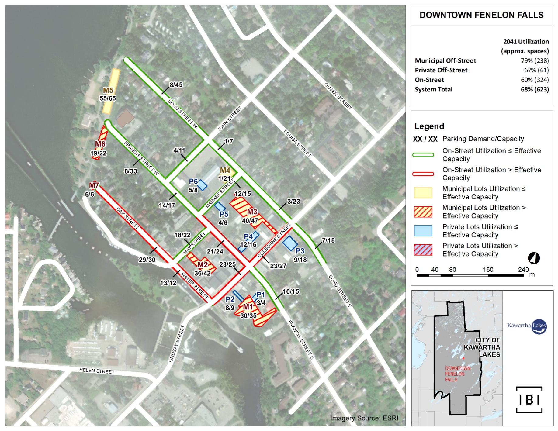
Exhibit 6-9 shows notional forecastedpeak utilization for the Bobcaygeon Core Area, after parking demand redistribution At peak demand, the parking system is anticipated to operateessentially ateffective capacity in 2041. While no opportunities for parking supply increases through reconfiguration of existing parking lots are evident, there are a few opportunities to increase on-street parking supply modestly through revision of pavement markings
Furthermore, there is a widely-recognized need for more long-vehicle and longterm parking on the periphery of the Core Area. Through a combination of duration-limited on-street parking, proactive enforcement and improved wayfinding, it is expected thatdemand for long-vehicle and long-term parking can be shifted toappropriate off-street parking assets within a reasonable distance of the Core Area.
Accordingly, it is recommended that the City implement the following measures relating to parking supplyin and around the Core Area:
• Revise pavement markings on Bolton St. and other streets, as may be applicable, to eliminateunnecessary “no parking” zones and optimize configuration, thereby increasing on-street parking supply modestly;
• Ensure the redevelopment of Bobcaygeon Beach Park provides ample space designated for long-vehicle and long-term parking to help alleviate congested parking assets in the Core Area during summer; and
• Expedite the paving of the Bobcaygeon Arena parking lot, whichis a project approved throughthe City’s 2020 Tax-Supported Capital Budget.
It is also recommended that the City implement the following parking demand management and enforcement measures in an effort tokeep peak utilization below effective capacity system-wide:
• Introduce a 2-hour parking duration limit to prime parking assets (e.g. Bolton St., Canal St., Lot M6 etc.) for the busy summer months (roughly Victoria Day to Labour Day), actively enforced by Municipal Law Enforcement Division or the Bobcaygeon Chamber of Commerce. Adjust the duration limit based on utilization and turnover. If parking demand is not better distributed or managed, consider instating paid on-street parking;
• Introduce proactive enforcement;
• Relocate the Farmers Marketfrom the Bobcaygeon Arenato Bobcaygeon Beach Park and, through a wayfinding system, direct long-vehicle and longterm parking to Bobcaygeon Beach Park and, during the summer months, the Bobcaygeon Arena; and
• Deputize Foodland owners andmanagers to empower them to enforce their parking lot. In consultation with Foodland, a parking time limit should be introduced to the lot as well.
DOWNTOWN PARKING STRATEGY
Prepared for the City of Kawartha Lakes
Exhibit 6-9: BobcaygeonCore Area| 2041 Peak Weekday Utilization Map
May 17, 2021
This section evaluates the City’s parkingservice in terms ofpolicies and administration, and develops related recommendations aimed atsupporting those made in Sections 5 and 6

Clear service level standardsare crucial to setting general expectations around municipal services and identifying the triggers for service expansion As previously discussed, three service level standards have guided the analysis and recommendations herein:
• Maximum system-wide peakparking utilization for municipal parking: 85%;
• Maximum system-wide peak parking utilization for private parking: 90%;and
• Maximum acceptable walking distance from parking location to destination: 400m
As a general rule, the City should observe maximum system-wide parking utilization rates of 85% and 90% for municipal and private parking facilities, respectively. Depending on the parking system size and layout, thesethresholds represent the point at which usersgenerally begin to experience excessive difficulty in finding available parking, leading to user frustration and excessive congestion caused by users searching for available parking for an extended period of time. In other words,these thresholds can be consideredto define “effective capacity”of a parking assetor system of such assets
As previously identified, an averagewalking distance of 240m to 360m from outdoor / uncovered parking facilities to adowntown destination is considered acceptable for the land uses within the three Core Areas.Based on that standard, a maximum walking distance of 400m between parking and destinations should be observed wherever reasonable, provided that accessible parking is adequate and optimally located.
To ensure service level standards are being met, the City should periodically complete the following process:
• Collect parking utilization data: Conduct hourly parking utilization counts during the winter or spring months in Lindsay and thesummer months in Fenelon Falls and Bobcaygeon. For all Core Area parking assets, this should be done between8:00 a.m. and 6:00 p.m. over two consecutive weekdays and 8:00 a.m. and 8:00 p.m. over two
May 17, 2021
consecutive Saturdays to ensuredaily parking demand fluctuations are captured.
• Assess existingconditions and forecast future conditions: Identify parking assets operating beyond effective capacity during the period of peak parking demand, as well as alternative parking opportunities within an acceptable walking distance of these assets Then forecast future parking demand to arrive at one of the following scenarios for each Core Area:
o The parking systemis projectedto operate below effective capacitywhereby all parking assets operatebelow effective capacity or particular parking assets operate above effective capacity but arewithin an acceptable walking distance of underutilized parking assets able to absorb localized excess demand.
Recommendation: No action needed.
o The parking system is projected to operate below effective capacity whereby particular parkingassets operate above effective capacity andare notwithin an acceptable walking distance of underutilized parking assets able to absorb localized excess demand.
Recommendation: Adopt strategies aimed at bringing about a better distribution ofparking demand, such as variable parking prices or duration limits,or dynamic wayfinding.
o The parking system is projected to operate above effective capacity.
Recommendation: First adopt strategies aimed at managing parking demand such asintroduced / increased parking prices, introduced / reduced maximum parking durations or enhanced parking enforcement. In the eventthat such measures are inadequate or politically infeasible, consider parking supply expansion.
7.1.1
The City is recommended tomaintain the following servicelevel standards in each of the Core Areas:
• Maximum system-wide peakparking utilization for municipal parking: 85%;
• Maximum system-wide peak parking utilizationfor private parking: 90%;and
• Maximum acceptable walking distance from parking location to destination: 400m
May 17, 2021
Four fundamental parking sign typesare known to enhance the experience of parking asset users:
Introduction: The first level of parking signage alerts drivers approaching parking areas. The signage should be distinct in both colour and size, and it can be characterized by unique logos. The signs should display the names of the lots and perhaps who the intended users are (e.g. permit holders, pay-as-youuseusers, long vehicles etc.). These signs are located on the street, and are mounted on poles at standard heights.
Directional: Directional parking signage is distinct in colour, size, and image and directs drivers tothe parking areas. The signs are mounted on poles at standard heights.
Identification: Identification signage is placed at the entry of each parking lot. The name of the parking area is identified and the type of parking available at the parking area is listed on the signage. The identification signage is distinctive in colour and size, andit is located on a pole at arelatively low height.
Pedestrian Wayfinding: These types of signs are placed at locations easily found and viewed bypedestrians, typically parking facility entry and exit points, and are intended to help pedestrians orient themselves in the Core Area.
Exhibit 7-1 shows examples of each of the four sign types discussed above.
Exhibit 7-1: Examples of Sign Types
May 17, 2021
Among thequalities of good signageare the following:
• The appearanceor themeof all signage is consistent;
• Use of common images, logos and colours;
• Placement at or near eye levelif intended for pedestrians;
• Use of reflective and durable material;
• All four wayfinding sign types (introduction, directional, identification, and pedestrian)are integrated toguide motorist and pedestrian activity;
• All primary entrances to the Core Areas have introduction signage;
• All major routes through the Core Areas have directional signage;
• All parking areas have identification signage;
• All pedestrian routes to and from major parking areas have wayfinding signs;
• The identification signs located at parking areas need to convey parkingprices, hours of operation, and maximum durations; and
• Exhibit lettering with a height of about 10 centimeters for urban streets (varies according to traffic speed).
While improved static signage to parking facilities helps reduce parking-related traffic congestion, more powerful tools are available through smart parking management systems, or dynamic wayfinding systems. These provide users with real-time parking occupancy data, enabling them to targetparking assets
May 17, 2021
with excess capacity, and with directional information to assist in wayfinding. Exhibit 7-2 shows a dynamic wayfinding sign that displays the number of spaces available per level within a parking garage.
Exhibit 7-2: Dynamic Wayfinding Sign
Dynamic wayfinding is an effective methodby which toimprove the parking experience for drivers searching for a space in a parking facility with multiple levels or among several adjacentlots. Drivers are able to see the real-time parking vacancies, and can go where the most parking is available to find a space. Dynamic wayfinding signs are ideally complemented with static directional signage at critical junctions to provide users with further guidance.
Complementary to signage and wayfinding systems would beonline maps showing all parking assets in the Core Areas. Municipal parking lot locations could also be added to Google Maps. These serviceswould improve awareness and utilization of Core Area parking systems, which is likely to result in improved distribution of parking demand. The webpage for the mapscould also encourage users (e.g. employees) requiring long-term parking to use off-street and peripheral parking assets, leavinghighly-valuableon-street assets for short-term uses with higher turnover rates, which is desirablefor both businesses and customers. The services of an online parkingmap could be augmented with a mobile parking applicationthrough whichusers can view parking facilities and their respective capacities.
7.2.2Recommendations
A wayfinding and signage strategy should be completedwith the following considerations in mind:
• Introduction signs at major entry points to the Core Area;
May 17, 2021
• Directional signs located in advance of anticipatedturning maneuvers;
• Identification signs located at all parking lot entrances – this would include naming / numbering, descriptions to aid in users’ spatial understanding, and a colour scheme on the identification signage to delineate municipal and private parking assets;
• Pedestrian signs located at eachparking lot’spedestrian access points;
• Addition of municipal parking lot locations to Google Maps; and
• Creation ofonline parking maps.
The parking requirementsprescribed bythe Lindsay, Fenelon Falls, and Bobcaygeon Zoning By-laws were compared to peer municipalities. The comparator municipalities are as follows:
• Township of King;
• Township of Uxbridge;
• Town of Georgina;
• Town of Orangeville;
• Municipality of Clarington;
• Town of Whitchurch-Stouffville;
• City of Woodstock;
• Town of Grimsby; and
• Town of Innisfil
The residential, office, retail, and restaurant land usetypes were selected for the comparison as theseland uses are considered most representative of land use in the City’s Core Areas
Exhibit 7-3 shows the comparison results.Based on the comparison, the City’s parking requirements are generally consistent with those of the comparator municipalities on average.
Exhibit 7-3: Comparison of Municipal Parking By-Law Requirements for Downtown Areas
(less than 1,200 m2) 2.0 per 100 m2 of GFA (more than 1,200 m2) 1 per 4 person or 10 per 100 m2 of GFA (whichever is greater)
Woodstock 1.1 per unit 2.0 per 100 m2 of GFA
Innisfil 1.75 per unit Ground floor: 3.6 per 100 m2 of GFA
floor: 2.7 per 100 m2 of GFA
per 100 m2 of GFA 1 per 4 person or 12.5 per 100 m2 of GFA (whichever is greater) Lindsay (Kawartha Lakes) 1.55 per unit (incl. visitor) 4.0 per 100 m2 of GFA
Fenelon Falls (Kawartha Lakes)
floor: 4.0 per 100 m2 of GFA
floor: 2.9 per 100 m2 of GFA 9.1 per 100 m2 of GFA
Bobcaygeon (Kawartha Lakes) 2 per unit 1 per business + 4.0 per 100 m2 of GFA 3.3 per 100 m2 of GFA 20.0 per 100 m2 of GFA
*Requirements with different formats were not included in the average.
May 17, 2021
May 17, 2021
• Consideration of site-specific applications to have parking requirements reduced for any particular development ought to have regard for the impact of such a reduction on the parking system of the relevant Core Area; and
• In cases of proposed developments for which provision of adequate onsite parkingis economically infeasible, the City should consider permitting development proponents to mitigate anticipated parking deficiencies throughagreements with owners of privateparking lots located within a walkable distance to the proposed development. Suchagreements should be made perpetualand robustthrough registration on title to all involved lands
The provision of funds necessary to operate, maintain, upgradeandexpand parking systems is a commonchallenge faced by municipalities. Cash-in-lieu of parkingpoliciespermitdevelopers to pay cashto municipalitiesas an alternative to providingsome orall of theminimum number of parking spaces required by the applicable zoning by-law. The fundsthereby collected are typically placed in a reserve fund used for the improvement and expansionof municipal parking systems.
Cash-in-lieu of parking is used by many Canadian municipalities as a mechanism tomitigate private parking supply deficiencies associated with development by increasing municipalparking supply, given the substitutability between private and municipal parking. It is principally used to address the challenges that arise when provision of on-site parking by developersis either impractical or prohibitively costly, but is also known to be used to:
• Encourage shared or short-term parking arrangements, discourage vehicle use, and promote and potentially fund transit;
• Intensify andor revitalize downtown cores (especially former surface lots); and
• Assure property owners that sufficient parking opportunities will be available.
Cash-in-lieu of parking usually applies toa specific geographic area, often a downtown or another area targeted for intensification or redevelopment, in which there is an acute public interest in ensuring adequate parking supply. Cash-inlieu of parking is most commonly applied tooffice developments, but in some municipalities it is also applied toretail and residential developments Upgrade and expansion of municipal parking supply in tandem with development may encourage a desirable mix of landuses in downtowncoresas well as support related economic development objectives. Some municipalities use a cash-in-
DOWNTOWN
May 17, 2021
lieu rate that represents approximately 50% of the costto provide a municipal parking space. Such an approach recognizes the spillover benefitof municipal parking to nearby properties.
Historically, the City has practiced cash-in lieu of parking in downtownLindsay, but with no established or consistent rate of payment. In downtownFenelon Falls, cash-in-lieu of parking is set at a rate of $4,000per parking space.Acashin-lieu of parking policydoes not exist for downtown Bobcaygeon. Through consultation with peer municipalities, cash-in-lieu of parkingrates were gathered, as shown in Exhibit 7-4 As indicated by Exhibit 7-4, approximately half of the consulted municipalities either do not have a cash-in-lieu of parking policy or levy a rate in accordance with a formula or the municipality’s discretion. For the peer municipalities that have a cash-in-lieu of parking policy, the rates range from $562 to $6,056 per space, with the average rate being $2,855 per space.
Whitchurch-Stouffville
Bobcaygeon
No current cash-in-lieu policy.
No current cash-in-lieu policy.
Based on required number of spaces, estimated land cost, estimated construction cost, and number of parking spaces missing.
Cost is at the discretion of the Town, depends on location and type of development.
Based on required number of spaces, estimated land cost, estimated construction cost, and number of parking spaces missing.
Cost is at the discretion of the City.
No current cash-in-lieu policy.
May 17, 2021
Based on the review’s results,Fenelon Falls’rate of cash-in-lieu of parking ($4,000 per space) is higher than the averageobserved in the peer municipalities. However,$4,000 is much lower than the cost to providea space of surface parking (approximately $15,000 to $20,000 per space).If municipal parking funded by cash-in-lieu of parking tends to benefit more than contributing developments, anappropriate cash-in-lieu rate could be $7,500 to $10,000 per space, assuming surface parking is built and a spillover rate of 50% With Fenelon Falls’ downtown municipal parking system exhibiting substantial excess capacity, even to 2041, it does not require the support of a cash-in-lieu of parking policy A similar conclusion holds for downtown Bobcaygeon, although thatprescription should be re-examined beforeutilization reaches effective capacity toward 2041.
Based on public and stakeholder comments, there is some community interest in having the City emplace an above-ground parking garage in downtown Lindsay to accommodate future parkingdemand. At a capacity of 200-400 parking spaces, such a facility is estimated to cost upwards of $45,000 per space, or $9M to $18Min total depending on size. Even at a contribution rate of 50%,the cash-in-lieu of parking ratefor such a facility would be upwards of $22,500 per space. However, actual rates of cash-in-lieu of parking levied in Lindsay have been a fraction of this anda fraction of even the amount needed to providea surface parking space. For example, according to City of Kawartha Lakes Council Report PLAN2018-046, it was recommended that cash-in-lieu of 100 parking spacesbe set at$76,362.64 (or$763.63 per parking space) for the proposed redevelopment of 171-183 Kent Street West, and Council supported that recommendation
Eventually, the municipal parking system in downtown Lindsay will need to be expanded, even if demand management measures areimplemented in the meantime. Regardless of the form (e.g. parking garage, surface parking etc.) it ultimately takes, that expansion will need to be funded somehow. As noted in Section 3.2.1, that funding could be raised throughone or more of the following:
• Cash-in-lieu of parking;
• Community benefits charges (replaces development charges for parking services as per the More Homes, More Choice Act);
• LDBIA levy;
• Capital or local improvement charges;
• Paid parking, inclusive of reinstatement of paid on-street parking; or
• General tax levy
As development in theCity is not sufficiently dense to make community benefits charges viable, as per City of Kawartha Lakes Council Report CA2020-001, that option can be eliminated from further consideration. Based on commentary
May 17, 2021
made atthe stakeholder and public consultations, the generally preferred option is an LDBIA levy, which aligns with the LDBIA having been the most vocal proponent for a parking garageand with the notion that expansion of the municipal parking systemwould chieflybenefit downtown businesses.
Recognizingthis, the significant contributionsof redevelopment to parking demandand the benefits conferred by municipal parking to the City as a whole, a case couldbe made to jointly fund municipal parking expansion with a combination of an LDBIA levy, cash-in-lieu of parking, paid parking and or general tax levy. Local capital or improvement charges could be used in place of an LDBIA levy or cash-in-lieu of parking.Determination of the optimal combination of financing instrumentsis, however, beyond the scope of this study. Until such a determination is made,it would be prudent to maintain some form of cash-in-lieu of parking policy in Lindsay.
• Abolish cash-in-lieu of parking for Fenelon Falls anddo not introduce cash-in-lieu of parking for Bobcaygeon;
• Determine the optimal mix offunding instruments to support the expansion of the municipal parking system in the Lindsay Core Area. Until that determination is made, maintain for downtown Lindsay some form of cash-in-lieu of parking in a consistent manner, and ensure the proceeds thereby raised are deposited into a parking reserve fund to be used exclusively for the upgrade and expansion of municipal parking in downtown Lindsay; and
• Payment of cash-in-lieu of parking should remain at the discretion of City Council to ensure that excess parking demand generated by proposed developments can be met by the municipal parking system.
This section examines theexisting administrative structure for the City’s parking service, reviews alternatives and modifications to that structure and develops recommendations accordingly.
7.5.1
In many ways, the existing manner in which the City’s parking service is administrated is a legacy of the amalgamationof the County of Victoria with its 16 constituent municipalities, which is the restructuring that formed the singletier City of Kawartha Lakes in 2001. Prior to amalgamation, parking services in the Town of Lindsay were provided by the Lindsay Parking Authority, an agency acting on behalf of the Town, while parking services in Fenelon Falls and Bobcaygeon were provided directly by the local municipalities through a combination of staff and contracted resources.
After amalgamation, the City dissolved the Lindsay Parking Authority and assigned responsibility for parking services to the Municipal Law Enforcement Division, Roads Operations Division and Engineering Division. Generally speaking, thesedivisions, respectively, provide for the enforcement, maintenance and capital aspects of the parking service. Much of the enforcement function in downtown Lindsay was delegated to the LDBIA upon removal of paid parking in late 2015 at the request of the LDBIA. Moreover, various property owners in downtown Lindsay were empowered by the Town of Lindsay to issue fines etc. to enforce parking by-laws applicable to their private lots, a practice continued by the City today.
Through discussions with City staff and consideration of industry best practices, IBI Group has identified opportunities for improvement to the City’s parking service. In large part, the intended outcomes of the improvements would be increased efficiency and or effectiveness. To inform recommendations made in that context, the following sections examinealternative service models that could point to potential improvements to the City’s parking service.
A parking division is a distinct part of the municipal administration led by a manger and dedicated exclusively to providing all aspects of a municipality’s parking service. The division would therefore be responsible for all capital and operating functions of the parking service, inclusive of policymaking and enforcement. Such adivision is appropriate when the scale and complexity of the parking service exceed that manageable by a multifunctional division but not that which would warrant a parking authority. Determination of a parking service’s scale and complexity should accountfor seasonality, especially in municipalities who routinelyexperience large influxes of seasonal residents and tourists.
A parking authority is a municipally-owned agency or corporation accountable to a governance board anddedicated exclusively to providing all aspects of a municipality’s parking service. An example is the Toronto Parking Authority, which manages on behalf of the City of Toronto approximately 59,000 parking spaces comprised of 19,000 on-street spaces, 22,000 off-street spaces, and 18,000 spaces owned by third parties such as the Toronto Transit Commission, Exhibition Place, and Toronto’s Parks, Forestry, and Recreation Divisions. The Toronto Parking Authority also manages Bike Share Toronto which consists of approximately 2,750 publicly available bicycles.
A municipality’s parking authority is governed by a board of directors, where directors are appointed by and accountable to the municipal council. Such a governance structure confers considerably more autonomy than isafforded to a parking division. A parking authority service model is appropriate when the scale and complexity of the parking service are sufficient to warrant autonomous administration and specialized expertise.
A public-private partnership (P3) is an arrangement, based on an agreement between a government and private-sector entity, for the purpose of financing, constructing and or operating public infrastructure and services. For municipal parking services, a typical P3 involves having the private sector partner emplace or upgrade parking facilities at its own expense, granting the private sector partner the right to operate and earn income from the facilities for a specified period and having the municipality resume operationsonce that period expires. Obviously, such an arrangement would require instatement of paid parking.
The potential benefits of partnering with a private entity are evident throughout the P3 agreement’s lifecycle. Overall, if everything goesas planned and the agreement is structured correctly, efficient and effective parking operations are achieved whereby the public is provided with a high-quality parking experience at a reasonable cost. Benefits associated with P3s include:
1. Access to Funding: Capital improvements to parking, such as new technologies and infrastructure upgrades, can be very expensive. Private entities may have access to forms and levels of capital financing to which municipalities do not.
2. Expertise: Private parking entitiesoften have experience and expertise not possessed by government; their knowledge of how to provide highquality parking cost-effectively can be leveraged.
May 17, 2021
3. Industry Networks: The private entity has likely worked in the industry long enough to have established relationships that can be leveraged. These relationshipshelp mitigate risk and manage costs.
4. Harnessing of Profit Motive: The private entity’s motive to earn profit can be harnessed to bring about efficiency and effectiveness in the provision of parking services.
5. Risk Management: There are a number of risks associated with constructing and operating a parking facility. A risk-averse municipality can transfer some or all of these risks to the private entity.
Although P3s present a number of benefits, there are also a number of drawbacks that must be considered:
1. Insufficient Return on Investment: Based on the level of risk associated with the P3, the private entity will have a minimum acceptable rate of return on investment in mind. If the market for parking services or the municipality’s political climate is such that that rate of return is difficult to meet (e.g. aversion to paid parking), a typical P3 may not even be feasible.
2. HighRiskPremium: The transferring of risk from the municipality to the private entity will come at a premium on theprivate entity’s required rate of return on investment. If that premium is sufficiently high, the municipality may be better off without a P3.
3. Costly Legal Fees: Depending on its term, scale and complexity, a P3 can entail significant legal costs for themunicipality, not only to establish the agreement but also to manage any disputes arising under it.
4. High Borrowing Costs: Financial institutions typically charge higher interest costs to private entities than to governments, given the taxing power of thelatter group.
5. Long-Term and Inflexible Agreement: The term of a P3 agreement typically ranges from 15 to 40 years, but it could be longer. Turnover in political leadership could result in the municipality seeking to move in directions contrary to the agreement. Moreover, in order for the P3 to work, the municipality must to some degree relinquish control of the subject parking facility. The degree of relinquishment is governed by the agreement, and is typically inversely related to the degrees of risk and responsibility transferred to the private entity.
7.5.5
The existing administrative structure of the City’s parking service is known to create inefficiencies and inconsistencies. Examples of such problems include
DOWNTOWN
May 17, 2021
excessive costs of removing snow in parking lots, insufficient attention to conditions (e.g. pavement markings, encroachments etc.) in parking lots, inadequate resources to enforce parking in Fenelon Falls and Bobcaygeon during peak demand in summer, and excessively divided attention across parking and non-parking by-law enforcement.Perhaps the principal challenge is that, while all Municipal Law Enforcement officers are able to enforce parking, the existing administrative structure and level of resources allowfor only a reactive approach to enforcement However, a proactive approach is needed, especially during seasons of heavy demand for parking.
Given the scale and complexity of the City’s parking service,and the general aversion to paid parking, neither a parking authority nor a typical P3 service model would be appropriate. While at thistime even a parking division would not be warranted, the existing administrative structure would do well to move somewhat in that direction.Specifically, a supervisory human resource should be added to the Municipal Law Enforcement Division, who would, among other things, manage the day-to-day enforcement and related operationalneeds of the City’s parking service. Suchan additionwould provide for a more proactive, consistent and focused approach to parkingenforcement and operations, as well as a more coordinated approach to the various beneficial nuances to service delivery such as those relating to delegated and private enforcement.
7.5.6Recommendations
• Create a supervisory position reporting to the Manager of Municipal Law Enforcement, and shift all day-to-day responsibility for parking enforcement and relatedoperations to the former position;
• Maintain responsibility for parking-relatedmaintenance (e.g. repair, painting, sweeping, signage replacement,inspection etc.) andcapital work (e.g. resurfacing, reconfiguration, drainage improvements, lighting improvements etc.)in the Roads Operations Division and Engineering Division, respectively;
• Maintaindelegation of parking enforcementin downtown Lindsay to the LDBIA, and provide thesame option to the local chambers of commerce in Fenelon Falls and Bobcaygeon;
• In lieu of paying the LDBIA directly forparking enforcement services, the City should permit the LDBIA to retain parking fine revenues it generates. Should parking fine revenue be insufficient to offset the cost of the service, the LDBIA has recourse to its own tax levy to make up the shortfall.This change will promote accountability and proactive parking enforcement in downtown Lindsay, given the LDBIA asked to be delegatedresponsibility for the service;
DOWNTOWN
May 17, 2021
• Continue to provide private property owners with the option to obtain the authority to enforce parking by-laws applicable to their parking lots;
• Increase the overtime parking fine to $40 andovernight parking fine to $30 to matchprevailing fines in peer municipalities;
• Adopt handheld license plate recognition (LPR) software to improve on-street parking enforcement in Lindsay. LPR-basedenforcement can be adopted in Bobcaygeon and Fenelon Falls in the future as parking demand grows;
• Provide snow removal with internal resources or by adding the service to an existing cost-effective outsourcing arrangement, such as that managed by Roads Operations Division or the Department of Community Services; and
• Undertake another Downtown Parking Strategy in 2029.
May 17, 2021
Through Exhibit 8-1, Exhibit 8-2, Exhibit 8-3, and Exhibit 8-4, this section summarizes the recommendations made in Sections6 and 7and outlines recommendationsdeveloped based on the findings of Section 5. The recommendations are organized by Core Area and those applicable City-wide, as well as by theme. Each recommendation is associated with a suggested timeline for implementation: short-term(1-2 years), medium term (3-5 years), long-term (beyond 5 years) and ongoing.To guide and qualify implementation of the recommendations, the City should conduct annual parking utilization surveys and continue to monitordevelopment activity and population growth. In particular, the City should be careful to trackparking supply changes and deficiencies arising from development activity in the Core Areas
While some users of the Core Areaparking systems may perceivea shortage of parking at certain times, this study shows that, based on industry best practices and utilization data,the existing parking supply is adequate to meet existing demand. Rather than a shortage of supply, existing parking challenges have been found to stem principally from (i) uneven distribution of parking activity,(ii) deficient wayfinding and awareness of the availability of parking and (iii) restrictive notions of an acceptable walking distance. Many of the recommendations made herein are designed to address such issues ortake advantage of low-cost expansions to parking supply wherever possible. Through to 2041, only the Lindsay Core Area is anticipated to require expansion to parking supply. Fortunately, halfof that expansion entails no or minimal added capital cost, primarilybecause it coincides with capital worksexpected to occur anyhow.
DOWNTOWN
Theme Recommendation
Lot M1
• Repaintthepavement markings
• Add signage to better identify the accessible parkingspaces.
Lot M2
• Repaint thepavement markings.
• Add signage to better identify the accessible parking spaces.
Lot M3
• Repaint thepavement markings.
• Add signage to better identify the accessible parking spaces.
Lot M4
• Repave the lot and paint new pavement markings.
May 17, 2021
• There are currently no accessible parking spaces in this lot. Delineate one accessible parking space through the use of pavement markings and signage.
Lot M5
• The garbage bins at the northeast corner of the parking are impeding parking supply. Relocate the bins to a location in the parking lot that will not impede parking supply.
• Paintnew pavement markingsso as to reconfigure the area and thereby gain approximately 10 spaces.
• Add a colour scheme or signage to distinguish Lot M5 from Lot P3 so that users are aware of the boundary between the lots
Lot M6
• Add signage to better identify the accessible parking spaces.
Short Term / Medium Term
DOWNTOWN
Theme Recommendation
Lot M7
• Repave the lot and paint new pavement markings.
• There are currently no accessible parking spaces in this lot. Delineate one accessible parking space through the use of pavement markings and signage
Lot M8
• Repave the lot and paint new pavement markings.
• Add signage for the 6 newly leased spaces in Lot M8 for Dr. Sun Dentistry to identify them as reserved spaces.
• Combine the remaining 2 unreserved spaces from Lot M8 with Lot M7.
Lot M9
• Repaint the pavement markings.
• Add a colour scheme or signage to distinguish Lot M9 from Lots P4 and P5 so that users are aware of the boundary between the lots.
Lot M10
• Add signage to better identify the accessible parking spaces.
May 17, 2021
DOWNTOWN
Theme Recommendation
• Upon relocation of the administrative offices for the Paramedic Service from 4 Victoria Ave. N., convert into public municipal parking (10 regular spaces and 1 accessible space) the 11 spaces in Lot M2 currently reserved for Paramedic Service vehicles and staff.
• Reconfigure Lot M5 to increase parking supply by approximately 10 spaces.
• Upon reconstruction or resurfacing of Victoria Ave. from Kent St. to Peel St., widen the street, close the entrance to Lot M2 and convert the parallel parking into angle parking to increase parking supply by approximately 34 spaces (from 20 to 54 spaces)
ParkingSupply Expansion
• Upon reconstruction or resurfacing of Kent St. from Victoria Ave. to Sussex St., widen the street and extend angle parking from Victoria Ave. to Sussex St., making allowance for turning lanes as needed, to increase parking supply by approximately 40 spaces
• Upon reconstruction or resurfacing of Peel St. from Victoria Ave. to Sussex St., close the entrance to Lot M1, widen the street to the south, maintain prohibited parking onthe north side and convert the parallel parking on the south side into angle parking to increase parking supply by approximately 12 spaces (from 12 to 24 spaces).
• Through a public-private partnership or other appropriate means, facilitate the consolidationand reconfiguration of the vacant / underutilized lands comprising and adjacent to Lot P9 (northeast corner of Victoria Ave. / Russell St.) to increase parking supply by approximately 114 spaces (from 106to 220 spaces).
Medium Term / Long Term
Parking Demand Management and Enforcement
May 17, 2021
• Introduce dynamic permit pricing to municipal parking lots. Increase pricing for the core lots (M2, M3, M4, and the forthcoming lot at 7 William St. S.), maintain pricing for the intermediate lots (M5, M9, and M10), and reduce pricing for the peripheral lots (M6 and M7)
• Reduce the duration for free off-street parking from 4 hours to 3 hours, where applicable,to increase demand for parking permits and help recover the costof the LPR technology.
• Maintain free 2-hour on-street parking and monitor implemented recommendations for two years. If parking demand is not better distributed or managed, consider reinstating paid on-street parking
Short Term / Medium Term
DOWNTOWN
Theme
Improvements to Parking Lots
Lot M1
Improvements to On-Street Parking
May 17, 2021
Recommendation
• Repave the lot and paint new pavement markings so as to reconfigure thelot and thereby gain approximately 35 spaces.
• There are currently no accessible parking spaces in this lot. Delineate one accessible parking space through the use of pavement markingsand signage.
Lot M2
• Repaint the pavement markings.
Lot M3
• Clear out all junk and unauthorized vehicles. Issue encroachmentnotices and warnings to all adjacent property owners. Issuefines for dumping,overnight parking etc. and practice proactive enforcement to keep the lot clean and operational.
• Add lighting to the parking lot to enhance visibility and public safety.
Lot M4
• Repaint the pavement markings.
Lot M6
• There are currently no accessible parking spaces in this lot. Delineate one accessible parkingspace through the use of pavement markings and signage
Lot M7
• Thereare currently no accessible parking spaces in this lot. Delineate one accessible parking space through the use of pavement markings and signage
Lot M8
• Repaint the pavement markings.
• Add signage to better identify the accessible parking spaces.
• Delineate parking along Oak Street, from May Street to the western limit, by adding pavement markings to the north side of the street and signage restricting parking on the other side (the street is too narrow to accommodate parking on both sides).
• Delineate parking on both sides of Bond Street, from the eastern limit of the study area to just east of the curved segment, adjacent to Garnet Graham Beach Park,to the west, by adding pavement markings.
Short Term
Short Term
DOWNTOWN
Theme Recommendation
• Upon reconstruction or resurfacing of Lot M1, reconfigure it to increase parking supply byapproximately 35 spaces.
Parking Supply Expansion
• Incorporate into the municipal parking system the site of the former Fenelon Falls Arena (southeast corner of Bond Street / John Street) to increase parking supply by approximately 70 spaces. Via a long vehicle routing plan and with the support of wayfinding signage, encourage long vehicles (e.g. trucks with boat trailers, buses, recreational vehicles etc.) to park in this lot.
• Introduce a 3-hour parking duration limit to prime parking assets (e.g. Colborne St , Water St., Lot M2 etc.) for the busy summer months (roughly Victoria Day to Labour Day), actively enforced by Municipal Law Enforcement Division or the Fenelon Falls Chamber of Commerce. Adjust the duration limit based on utilization and turnover.
Parking Demand Management and Enforcement
May 17, 2021
• Issue residential parking permits via LPR technology to Colborne Street residents who have no access to private parking (i.e. those presently reliant on on-street parking) and allow them to park anywhere in Lot M3 with no time restrictions
• Introduce proactive enforcement
• Where Oak Street intersects Water Street and May Street, install signage at all approaches that restrictslong vehicles from entering Oak Street
• Create a long vehicle route as follows: Launch boats at the western limit of Water Street, take May Street to Francis Street to John Street and park in the new lot. Signage should be installed at all intersections along this route to direct driverswith trailers to the new lot after launching their boats.
DOWNTOWN
Theme
Improvements
Lot M1
Parking Supply Expansion
May 17, 2021
Recommendation Implementation
• Repaint the pavement markings.
Lot M2
• Delineate accessible parking spaces with pavement markings and signage
Lot M3
• There are currently no accessible parking spaces in this lot. Delineate one accessible parking space through the use of pavement markings and signage
Lot M4
• There are currently no accessible parking spaces in this lot. Delineate one accessible parking space through the use of pavement markings and signage
• Add a colour scheme or signageto distinguish Lot M4 from Lot P4 so that users are aware of the boundary between the lots
Lot M5
• There are currently no accessible parking spaces in this lot. Delineate one accessible parking space through the use of pavement markings and signage
Lot M6
• Add signage to better identify the accessible parking spaces.
• Revise pavement markings on Bolton St. and other streets, as may be applicable, to eliminate unnecessary “no parking” zones and optimize configuration, thereby increasing on-street parking supply modestly
• Ensure the redevelopment of Bobcaygeon Beach Park provides ample space designated for long-vehicle and long-term parking to help alleviate congested parking assets in the Core Area during summer
• Expedite the paving of the Bobcaygeon Arena parking lot, which is a project approved through the City’s 2020 Tax-Supported Capital Budget.
Short Term
DOWNTOWN
Parking Demand Management and Enforcement
• Introduce a 2-hour parking duration limit to prime parking assets (e.g. Bolton St., Canal St., Lot M6 etc.) for the busy summer months (roughly Victoria Day to Labour Day), actively enforced by Municipal Law Enforcement Division or the Bobcaygeon Chamber of Commerce. Adjust the duration limit based on utilization and turnover. If parking demand is not better distributed or managed, consider instating paid on-street parking
• Introduce proactive enforcement
• Relocate the Farmers Market from the Bobcaygeon Arena to Bobcaygeon Beach Park and, through a wayfinding system, direct long-vehicle and long-term parking to Bobcaygeon Beach Park and, during the summer months, the Bobcaygeon Arena
• Deputize Foodland owners and managers to empower them to enforce their parking lot. In consultation with Foodland, a parking time limit should be introducedto the lot as well.
• Maximum system-wide peak parking utilization for municipal parking: 85%;
Service Level Standards
• Maximum system-wide peak parking utilization for private parking: 90%; and
• Maximum acceptable walking distance from parking location to destination: 400m.
A wayfinding and signage strategy should be completed with the following considerations in mind:
• Introduction signs at major entry points to the Core Area.
• Directional signs located in advance of anticipated turning maneuvers.
Wayfinding Improvements
Parking Requirements
May 17, 2021
• Identification signs located at all parking lot entrances – this would include naming / numbering, descriptions to aid in users’ spatial understanding, and a colour scheme on the identification signage to delineate municipal and private parking assets.
• Pedestrian signs located at each parking lot’s pedestrian access points
• Addition ofmunicipal parking lot locations to Google Maps.
• Creation ofan online parking maps.
• Consideration of site-specific applications to have parking requirements reduced for any particular development ought to have
DOWNTOWN
Theme Recommendation
Implementation Timeline in Zoning ByLaws regard for the impact of such a reduction on the parking system of the relevant Core Area.
• In cases of proposed developments forwhich provision of adequate on-site parking is economically infeasible, the City should consider requiring development proponents to mitigate anticipatedparking deficiencies through agreements with owners of private parking lots located within a walkabledistance to the proposed development. Such agreements should be made perpetual and robust through registration on title to all involved lands.
• Abolish cash-in-lieu of parking for Fenelon Falls and do not introduce cash-in-lieu of parking for Bobcaygeon.
Cash-in-Lieu of Parking Policies
May 17, 2021
• Determine the optimal mix of funding instruments tosupport the expansion of the municipal parking system in the Lindsay Core Area. Until that determination is made, maintain for downtown Lindsay some form of cash-in-lieu of parking in a consistent manner, and ensure the proceeds thereby raised are deposited into a parking reserve fund to be used exclusively for the upgrade and expansion of municipal parking in downtown Lindsay.
• Payment of cash-in-lieu of parking should remain at the discretion of City Council to ensure that excess parking demand generated by proposed developments can be met by the municipal parking system.
Short Term
DOWNTOWN
Theme Recommendation
• Create a supervisory position reporting to the Manager of Municipal Law Enforcement, and shift all day-to-day responsibility for parking enforcement and related operations to the former position
• Maintain responsibility for parking-related maintenance (e.g. repair, painting, sweeping,signage replacement, inspection etc.) and capital work (e.g. resurfacing, reconfiguration, drainage improvements, lighting improvements etc.) in the Roads Operations Division and Engineering Division, respectively.
• Maintain delegation of parking enforcement in downtown Lindsay to the LDBIA, and provide the same option to the local chambers of commerce in Fenelon Fallsand Bobcaygeon
Parking Service Administration
• In lieu of paying the LDBIA directly for parking enforcement services, the City should permit the LDBIA to retain parking fine revenues it generates. Should parking fine revenue be insufficient to offset the cost of the service, the LDBIA has recourse to its own tax levy to make up the shortfall. This change will promote accountability and proactive parking enforcement in downtown Lindsay, given the LDBIA asked to be delegated responsibility for the service
• Continue to provide private property owners with the option to obtain the authority to enforce parking by-laws applicable to their parking lots;
• Increase the overtime parking fine to $40 and overnight parking fine to $30 to match prevailing fines in peer municipalities.
• Adopt handheld license plate recognition (LPR) software to improve on-street parking enforcement in Lindsay. LPR-based enforcement can be adopted in Bobcaygeon and Fenelon Falls in the future as parking demand grows.
• Provide snow removal with internal resources or by adding the service to an existing cost-effective outsourcing arrangement, such as that managed by Roads Operations Division or the Department of Community Services.
• Undertake another Downtown Parking Strategy in 2029.
Short Term / Medium Term / Long Term / Ongoing
May 17, 2021
Online Survey and Crowd Sourcing Map Results
Lindsay ‐Summer 2019 ‐Lot P3
Lindsay ‐Summer 2019 ‐Lot P10
Lindsay ‐Winter 2018 ‐Cambridge St from Kent St to Russell St
Lindsay ‐Summer 2019 ‐Cambridge St from Kent St to Russell St
Lindsay ‐Spring 2019 ‐Cambridge St from Kent St to Russell St
Lindsay ‐Winter 2018 ‐Kent St from Cambridge St to William St
Lindsay ‐Summer 2019 ‐Kent St from Cambridge St to William St
Lindsay ‐Spring 2019 ‐Kent St from Cambridge St to William St
Lindsay ‐Winter 2018 ‐Kent St from Lindsay St to Mill St
Lindsay ‐Summer 2019 ‐Kent St from Lindsay St to Mill St
Lindsay ‐Spring 2019 ‐Kent St from Lindsay St to Mill St
Lindsay ‐Winter 2018 ‐Kent St from Victoria Ave to Cambridge St
Lindsay ‐Summer 2019 ‐Kent St from Victoria Ave to Cambridge St
Lindsay ‐Spring 2019 ‐Kent St from Victoria Ave to Cambridge St
Lindsay ‐Winter 2018 ‐Kent St from William St to York St
Lindsay ‐Summer 2019 ‐Kent St from William St to York St
Lindsay ‐Spring 2019 ‐Kent St from William St to York St
Lindsay ‐Winter 2018 ‐Kent St from York St to Lindsay St
Lindsay ‐Summer 2019 ‐Kent St from York St to Lindsay St
Lindsay ‐Spring 2019 ‐Kent St from York St to Lindsay St
Lindsay ‐Winter 2018 ‐Peel St from Cambridge St to William St
Lindsay ‐Summer 2019 ‐Peel St from Cambridge St to
Lindsay ‐Spring 2019 ‐Peel St from Cambridge St to William St
Lindsay ‐Winter 2018 ‐Peel St from Sussex St to Victoria Ave
Lindsay ‐Summer 2019 ‐Peel St from Sussex St to Victoria Ave
Lindsay ‐Spring 2019 ‐Peel St from Sussex St to Victoria Ave
Lindsay ‐Winter 2018 ‐Peel St from Victoria Ave to Cambridge St
Lindsay ‐Summer 2019 ‐Peel St from Victoria Ave to Cambridge St
Lindsay ‐Spring 2019 ‐Peel St from Victoria Ave to Cambridge St
Lindsay ‐Winter 2018 ‐Peel St from William St to York St
Lindsay ‐Summer 2019 ‐Peel St from William St to York St
Lindsay ‐Spring 2019 ‐Peel St from William St to York St
Lindsay ‐Winter 2018 ‐Ridout St from Lindsay St to Mill St
Lindsay ‐Summer 2019 ‐Ridout St from Lindsay St to Mill St
Lindsay ‐Spring 2019 ‐Ridout St from Lindsay St to Mill St
Lindsay ‐Winter 2018 ‐Sussex St from Kent St to Russell St
Lindsay ‐Summer 2019 ‐Sussex St from Kent St to Russell St
Lindsay ‐Spring 2019 ‐Sussex St from Kent St to Russell St
Lindsay ‐Winter 2018 ‐Sussex St from Peel St to Kent St
Lindsay ‐Summer 2019 ‐Sussex St from Peel St to Kent St
Lindsay ‐Spring 2019 ‐Sussex St from Peel St to Kent St
Lindsay ‐Winter 2018 ‐Victoria Ave from Kent St to Russell St
Lindsay ‐Summer 2019 ‐Victoria Ave from Kent St to Russell St
Lindsay ‐Spring 2019 ‐Victoria Ave from Kent St to Russell St
Lindsay ‐Winter 2018 ‐Victoria Ave from Peel St to Kent St
Lindsay ‐Summer 2019 ‐Victoria Ave from Peel St to Kent St
Lindsay ‐Spring 2019 ‐Victoria Ave from Peel St to Kent St
Lindsay ‐Winter 2018 ‐William St from Kent St to Russell St
Lindsay ‐Summer 2019 ‐William St from Kent St to Russell St
Lindsay ‐Spring 2019 ‐William St from Kent St to Russell St
Lindsay ‐Winter 2018 ‐William St from Peel St to Kent St
Lindsay ‐Summer 2019 ‐William St from Peel St to Kent St
Lindsay ‐Spring 2019 ‐William St from Peel St to Kent St
Lindsay ‐Winter 2018 ‐York St from Peel St to Kent St
Lindsay ‐Summer 2019 ‐York St from Peel St to Kent St
Lindsay ‐Spring 2019 ‐York St from Peel St to Kent St Spring Weekday
Fenelon Falls ‐Winter 2018 ‐Bond St from Colborne St to 100m east of Colborne St
Fenelon Falls ‐Spring 2019 ‐Bond St from Colborne St to 100m east of Colborne St
Fenelon Falls ‐Summer 2019 ‐Bond St from Colborne St to 100m east of Colborne St
Fenelon Falls ‐Winter 2018 ‐Bond St from John St to Market St
Fenelon Falls ‐Spring 2019 ‐Bond St from John St to Market St
Fenelon Falls ‐Summer 2019 ‐Bond St from John St to Market St
Fenelon Falls ‐Winter 2018 ‐Bond St from Market St to Colborne St
Fenelon Falls ‐Spring 2019 ‐Bond St from Market St to Colborne St
Fenelon Falls ‐Summer 2019 ‐Bond St from Market St to Colborne St
Fenelon Falls ‐Winter 2018 ‐Bond St from West end of street to John St
Fenelon Falls ‐Spring 2019 ‐Bond St from West end of street to John St
Fenelon Falls ‐Summer 2019 ‐Bond St from West end of street to John St
Fenelon Falls ‐Winter 2018 ‐Colborne St from Bond St to Francis St
Fenelon Falls ‐Spring 2019 ‐Colborne St from Bond St to Francis St
Fenelon Falls ‐Summer 2019 ‐Colborne St from Bond St to Francis St
Fenelon Falls ‐Winter 2018 ‐Colborne St from Francis St to Water St
Fenelon Falls ‐Spring 2019 ‐Colborne St from Francis St to Water St
Fenelon Falls ‐Summer 2019 ‐Colborne St from Francis St to Water St
Fenelon Falls ‐Winter 2018 ‐Francis St from Colborne St to 100m east of Colborne St
Fenelon Falls ‐Spring 2019 ‐Francis St from Colborne St to 100m east of Colborne St
Fenelon Falls ‐Summer 2019 ‐Francis St from Colborne St to 100m east of Colborne St
Fenelon Falls ‐Winter 2018 ‐Francis St from John St to Market St
Fenelon Falls ‐Spring 2019 ‐Francis St from John St to Market St
Fenelon Falls ‐Summer 2019 ‐Francis St from John St to Market St
Fenelon Falls ‐Winter 2018 ‐Francis St from Market St to Colborne St
Fenelon Falls ‐Spring 2019 ‐Francis St from Market St to Colborne St
Fenelon Falls ‐Summer 2019 ‐Francis St from Market St to Colborne St
Fenelon Falls ‐Winter 2018 ‐Francis St from West end of street to John St
Fenelon Falls ‐Spring 2019 ‐Francis St from West end of street to John St
Fenelon Falls ‐Summer 2019 ‐Francis St from West end of street to John St
Fenelon Falls ‐Winter 2018 ‐John St from Bond St to Francis St
Fenelon Falls ‐Spring 2019 ‐John St from Bond St to Francis St
Fenelon Falls ‐Summer 2019 ‐John St from Bond St to Francis St
Fenelon Falls ‐Winter 2018 ‐Market St from Bond St to Francis St
Fenelon Falls ‐Spring 2019 ‐Market St from Bond St to Francis St
Fenelon Falls ‐Summer 2019 ‐Market St from Bond St to Francis St
Fenelon Falls ‐Winter 2018 ‐May St from Francis St to Water St / Oak St
Fenelon Falls ‐Spring 2019 ‐May St from Francis St to Water St / Oak St
Fenelon Falls ‐Summer 2019 ‐May St from Francis St to Water St / Oak St
Fenelon Falls ‐Winter 2018 ‐Oak St from 100m west of May St to May St
Fenelon Falls ‐Spring 2019 ‐Oak St from West end of street to May St
Fenelon Falls ‐Summer 2019 ‐Oak St from West end of street to May St
Fenelon Falls ‐Winter 2018 ‐Water St from May St to Colborne St
Fenelon Falls ‐Spring 2019 ‐Water St from May St to Colborne
Fenelon Falls ‐Summer 2019 ‐Water St from May St to Colborne St
Bobcaygeon ‐Spring 2019 ‐Lot M1
Bobcaygeon ‐Winter 2018 ‐Lot M4
Bobcaygeon ‐Spring 2019 ‐Lot M4
Bobcaygeon ‐Spring 2019 ‐Lot M5
Bobcaygeon ‐Winter 2018 ‐Lot P2
Bobcaygeon ‐Summer 2019 ‐Lot P2
Bobcaygeon ‐Spring 2019 ‐Lot P2
Bobcaygeon ‐Winter 2018 ‐Lot P3
Bobcaygeon ‐Summer 2019 ‐Lot P3
Bobcaygeon ‐Spring 2019 ‐Lot P3
Bobcaygeon ‐Winter 2018 ‐Lot P4
Bobcaygeon ‐Summer 2019 ‐Lot P4
Bobcaygeon ‐Winter 2018 ‐Bolton St from Canal St to King St
Bobcaygeon ‐Spring 2019 ‐Bolton St from Canal St to South end of street
Bobcaygeon ‐Summer 2019 ‐Bolton St from Canal St to South end of street
Bobcaygeon ‐Winter 2018 ‐Canal St from Main St / Bolton St to William St
Bobcaygeon ‐Spring 2019 ‐Canal St from Main St / Bolton St to William St
Bobcaygeon ‐Summer 2019 ‐Canal St from Main St / Bolton St to William St
Bobcaygeon ‐Winter 2018 ‐Front St from John St to Main St
Bobcaygeon ‐Spring 2019 ‐Front St from John St to Main St
Bobcaygeon ‐Summer 2019 ‐Front St from John St to Main St
Bobcaygeon ‐Winter 2018 ‐Front St from Main St to 50m east of Main St
Bobcaygeon ‐Spring 2019 ‐Front St from Main St to 50m east of Main St
Bobcaygeon ‐Summer 2019 ‐Front St from Main St to 50m east of Main St
Bobcaygeon ‐Winter 2018 ‐Joseph St from 50m north of Queen St to Queen St
Bobcaygeon ‐Spring 2019 ‐Joseph St from 50m north of Queen St to Queen St
Bobcaygeon ‐Summer 2019 ‐Joseph St from 50m north of Queen St to Queen St
Bobcaygeon ‐Winter 2018 ‐King St from Bolton St to William St
Bobcaygeon ‐Spring 2019 ‐King St from Bolton St to William St
Bobcaygeon ‐Summer 2019 ‐King St from Bolton St to William St
Bobcaygeon ‐Winter 2018 ‐King St from Sherwood St to Bolton St
Bobcaygeon ‐Spring 2019 ‐King St from Sherwood St to Bolton St
Bobcaygeon ‐Summer 2019 ‐King St from Sherwood St to Bolton St
Bobcaygeon ‐Winter 2018 ‐King St from William St to Need St
Bobcaygeon ‐Spring 2019 ‐King St from William St to Need St
Bobcaygeon ‐Summer 2019 ‐King St from William St to Need St
Bobcaygeon ‐Winter 2018 ‐Main St (Island) from 90 degree turn to Canal St
Bobcaygeon ‐Spring 2019 ‐Main St (Island) from 90 degree turn to Canal St
Bobcaygeon ‐Summer 2019 ‐Main St (Island) from 90 degree turn to Canal St
Bobcaygeon ‐Winter 2018 ‐Main St (Island) from Front St to 90 degree turn
Bobcaygeon ‐Spring 2019 ‐Main St (Island) from Front St to 90 degree turn
Bobcaygeon ‐Summer 2019 ‐Main St (Island) from Front St to 90 degree turn
Bobcaygeon ‐Winter 2018 ‐Main St from 50m north of Queen St to Queen St
Bobcaygeon ‐Spring 2019 ‐Main St from 50m north of Queen St to Queen St
Bobcaygeon ‐Summer 2019 ‐Main St from 50m north of Queen St to Queen St
Bobcaygeon ‐Winter 2018 ‐Main St from Queen St to Front St
Bobcaygeon ‐Spring 2019 ‐Main St from Queen St to Front St
Bobcaygeon ‐Summer 2019 ‐Main St from Queen St to Front St
Bobcaygeon ‐Winter 2018 ‐Queen St from 50m west of Main St to Main St
Bobcaygeon ‐Spring 2019 ‐Queen St from 50m west of Main St to Main St
Bobcaygeon ‐Summer 2019 ‐Queen St from 50m west of Main St to Main St
Bobcaygeon ‐Winter 2018 ‐Sherwood St from Canal St to King St
Bobcaygeon ‐Spring 2019 ‐Sherwood St from Canal St to King St
Bobcaygeon ‐Summer 2019 ‐Sherwood St from Canal St to King St
Bobcaygeon ‐Winter 2018 ‐William St from Canal St to King St
Bobcaygeon ‐Spring 2019 ‐William St from Canal St to King St
Bobcaygeon ‐Summer 2019 ‐William St from Canal St to King St
Municipal Parking Lot Asset Registry