
LANDSLIDE MITIGATION
GUIDELINES FOR SAFEGUARDING KONKAN VILLAGES
Under the Guidance of Ar.Abhijit Kondhalkar
Karishma RawoolLANDSLIDE MITIGATION GUIDELINES FOR SAFEGUARDING KONKAN VILLAGES
 Karishma Rawool
Under the Guidance of Ar.Abhijit
KondhalkarAcknowledgment
I extend my profound gratitude to Ar. Abhijit Kondhalkar, an eminent figure in the realm of urban design and architecture, whose invaluable guidance and steadfast support have been instrumental throughout the entirety of my academic pursuit, particularly in the development of my thesis, "Landslide Resilient Architecture for Konkan Region: Case of Gothvewadi," and the subsequent creation of my comprehensive guidelines booklet aimed at mitigating landslides and safeguarding the villages of Konkan
Ar Kondhalkar's extensive experience, garnered over years of dedicated practice and research, has served as an invaluable resource, enriching my understanding of the intricate complexities inherent in addressing the challenges posed by landslide-prone settlements. His astute insights and perceptive feedback have not only illuminated the path of my research but have also catalyzed a deeper exploration into the underlying issues and potential solutions.
Moreover, it is through his unwavering commitment to effecting tangible change in the urban landscape that I have been inspired to delve beyond the confines of theoretical discourse and embark on a journey towards pragmatic action His unwavering dedication to bridging the gap between academia and practice has encouraged me to transform my academic endeavors into actionable proposals with the potential to effect meaningful change in real-world scenarios.
Beyond his role as a mentor and academic guide, Ar. Kondhalkar has been a source of unwavering encouragement and motivation, instilling in me a sense of confidence and purpose that transcends the confines of academia. His belief in my abilities has not only bolstered my academic pursuits but has also imbued me with the courage to pursue innovative approaches and challenge conventional wisdom in the pursuit of impactful solutions.
I am deeply grateful for Ar. Kondhalkar's patience, sage advice, and unwavering support, which have served as pillars of strength throughout the arduous journey of academic research and thesis development. His mentorship has not only shaped my academic trajectory but has also instilled in me a profound sense of responsibility towards addressing critical societal issues and effecting positive change in the world around me
In summation, I extend my heartfelt appreciation to Ar Abhijit Kondhalkar for his unparalleled guidance, unwavering support, and unwavering belief in my abilities. It is through his mentorship that I have been empowered to push the boundaries of academic inquiry, strive for excellence, and make meaningful contributions towards the betterment of society, particularly in the realm of landslide mitigation and village safety in the Konkan region.
3
Introduction
Chapter 1: Development of Regional Hydrology Plan
Chapter 2: Demarcation of Landslide Risk Villages
Chapter 3: Assessment of Heavy Rainfall Patterns
Chapter 4: Monitoring Soil Water Saturation
Chapter 5: Landslide and Mudslide Hazard Mapping
Chapter 6: Soil Testing and Analysis
Chapter 7: Implementation of Vegetative Strategies
Chapter 8: Sustainable Retaining Wall
Chapter 9: Settlement Mapping and Vulnerability Assessment
Chapter 10: Drainage System Mapping
Chapter 11: Material Testing for Lightweight and Sustainable Solutions
Chapter 12: Integration of Structural Resilience Strategies
Table of Contents
……………………………………….....………………………………..05 ..………………………………06 ………………………………….08 ………………………………….10 ……………………………………….12 ……………………………….13 ………………………...………………………15 ………………...………………..16 …………..……………………………………18 …….………………21 ……………………………………………23 ….……….24 ………………………..25 4
Introduction
In recent years, the Sahyadri hills of the Konkan region have seen an alarming increase in landslides, posing serious dangers to the safety and sustainability of the villages located within these settings. Recognizing the vital need for taking preventive steps to address this severe problem, this booklet seeks to present a complete set of instructions designed specifically for landslide mitigation in the Konkan region.
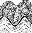
Landslides, which are defined as the downward movement of rock, soil, and debris along a slope, not only results in loss of life and property damage, but also have longterm socioeconomic consequences for the communities affected. Therefore, the need of developing effective mitigation guidelines is highly essential
Development of Regional Hydrology Plan Demarcation of Landslide Risk Villages
Soil Testing and Analysis Implementation of Vegetative Strategies
Integration of Structural Resilience Strategies
Assessment of Heavy Rainfall Patterns
Landslide and Mudslide Hazard Mapping
Monitoring Soil Water Saturation
Sustainable Retaining Wall Wherever Necessary
Material Testing for Lightweight and Sustainable Solutions
Settlement Mapping and Vulnerability Assessment Drainage System Mapping
This booklet is intended to serve as a definitive resource for engineers and individuals involved in the evaluation, mapping, and mitigation of landslide risks in the Konkan region The study establishes a systematic process for identifying landslide-prone villages by thoroughly investigating the geological, topographical, and environmental aspects inherent in this terrain
Furthermore, the booklet dives into the complexities of mapping landslide risk zones, including the methodology and technologies required for proper risk assessment. By identifying the primary causes and triggers of landslides in the Sahyadri mountains, including as geological instability, precipitation patterns, and human interventions, this booklet offers the framework for effective landslide mitigation decisions.
Furthermore, the guidelines provided below include both structural and vegetative approaches to landslide mitigation, catering to the different needs and constraints faced by the Konkan region. From construction requirements that prioritize slope stability and resilience to vegetation methods that improve soil retention and erosion control, this comprehensive strategy aims to promote sustainable development practices while protecting the region's ecological integrity Furthermore, the booklet focuses on the necessity of proactive measures by providing universal standards for slope development, ensuring that future construction projects take landslide vulnerability into consideration.
5
Chapter 1: Development of Regional Hydrology Plan
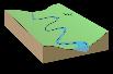
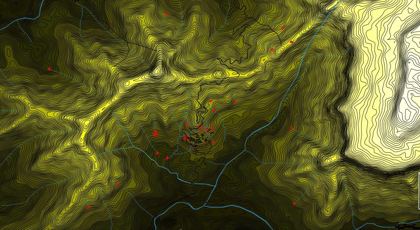
A regional hydrology map can help identify settlements at risk of landslides in the Sahyadri mountain ranges by identifying areas prone to water saturation, which is an important factor contributing to landslides. The map identifies locations where soil is vulnerable to sliding by highlighting regions with significant water saturation, making it easier to map landslide risk zones. This vital data will enable authorities to prioritize disaster management efforts, implement preventive measures, and notify vulnerable communities, reducing the effect of possible landslides and protecting lives and infrastructure
The process to create a regional-level hydrology map involves the following steps:
STEP 1
Data Compilation

STEP 3
Division of Contours and Color Legend


STEP 2
Contour Map Creation
STEP 4
STEP 5
Delineation of Water Flow Paths
STEP 7
Integration of Hydrological Features


STEP 6
Valleys & Ridges Identification
Water Accumulation Area Mapping
1. Data Compilation: The first stage is to collect relevant data, such as topographic maps, satellite photos, and rainfall records, in order to precisely define the region's terrain
2. Contour Map Creation: Using the data gathered, a regional contour map is created that depicts elevation changes across the landscape. Contours are lines that connect places of equal elevation and allow you to see how steep the terrain is and how the slopes vary.
3. Division of Contours and Color Legend: Contour map is separated into distinct elevation bands or height intervals, as indicated by the color legend. A color legend assigns a unique hue or shade to each interval, making it easier to identify elevation differences across the region
4. Valleys and Ridges Identification: The contour map distinguishes valleys, which are low-lying areas between hills or mountains, from ridges, which are raised landforms between valleys. These features are important in creating hydrology map and are significant predictors of landslide susceptibility.
5. Delineation of Water Flow Paths: Water Flow Paths are mapped using the contour map as a reference, tracing the region's natural drainage patterns. This entails determining the direction of surface water flow from higher to lower altitudes, usually through valleys and depressions.
6
6. Water Accumulation Area Mapping: Natural topographic characteristics such as depressions or concave slopes cause water to gather or stop in particular areas. These locations are prone to water saturation, which increases soil moisture and reduces slope stability, raising the danger of landslides.
7. Integration of Hydrological Features: The water flow channels and accumulation regions found on the hydrology map are combined with other relevant data, such as soil properties and land use patterns, to comprehensively assess landslide vulnerability.
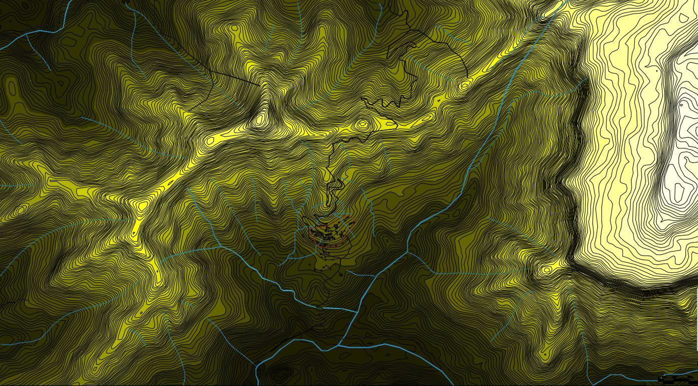
The creation of a regional level hydrology map represents a pivotal phase in identifying villages susceptible to landslides within the Sahyadri mountain ranges. Through meticulous data compilation and analysis, incorporating topographic maps, satellite imagery, and rainfall records, this process facilitates the visualization and interpretation of critical hydrological features pivotal in influencing slope stability. By precisely delineating water flow paths, accumulation areas, and other hydrological nuances, the hydrology map emerges as an indispensable tool for comprehensively assessing landslide susceptibility.
Such detailed insights lay the groundwork for the formulation of robust landslide mitigation strategies and informed land use planning initiatives. The hydrology map furnishes invaluable information that serves as the cornerstone for proactive measures aimed at enhancing the resilience of communities residing in landslide-prone regions In the next chapter, our focus shifts towards the demarcation of villages at heightened risk of landslides, leveraging the insights garnered from the regional level hydrology map to prioritize and implement targeted mitigation efforts. By aligning our actions with the data-driven insights provided by the hydrology map, we endeavor to fortify the safety and well-being of the inhabitants inhabiting these vulnerable areas, underscoring our commitment to proactive risk management and sustainable development practices.
7
Img No. 01 Regional Level Hydrology Map Source: Author
Chapter 2: Demarcation of Landslide Risk Villages
Demarcating villages susceptible to landslides in the Sahyadri mountain ranges involves a systematic approach, integrating insights gleaned from the regional level hydrology map. The process encompasses the following steps:
Utilizing Hydrology Map Data
Defining Susceptible Zones
Mapping Susceptible Villages
Prioritizing Mitigation Efforts
Avoiding Construction in Vulnerable Areas
Community Awareness and Preparedness
1. Utilizing Hydrology Map Data: Begin by referencing the hydrology map to identify areas within valleys where water accumulates, leading to saturation of the soil and increased landslide susceptibility Mark these points on the map as they indicate regions prone to heightened risk of landslides.
2. Defining Susceptible Zones: Establish a buffer zone around the marked points, extending to a radius of 5 meters This zone delineates the immediate vicinity where soil destabilization and increased water saturation heighten the risk of landslides Recognize this area as particularly susceptible to landslide occurrences.
3. Mapping Susceptible Villages: Overlay the delineated susceptible zones onto the map of the Sahyadri mountain villages Identify villages located within or adjacent to these zones as potentially vulnerable to landslides. Consider factors such as proximity to steep slopes, soil composition, and historical landslide occurrences to refine the demarcation process further.
Step 1 Step 2 Step 3 Step 4 Step 5 Step 6
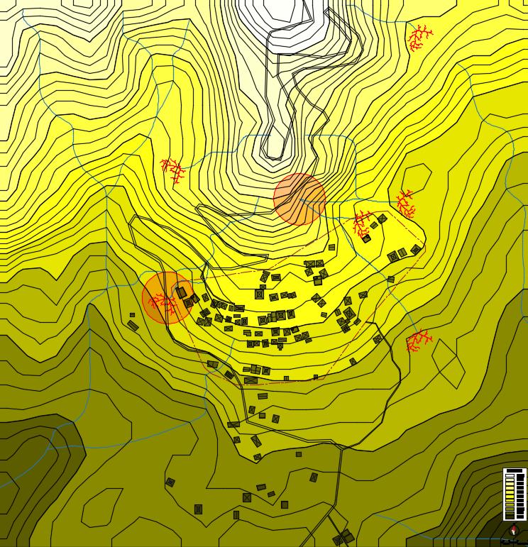
. 8 Img No. 02 Regional Level Landslide Risk Zone Map Source: Author
4. Prioritizing Mitigation Efforts: Prioritize villages located within the identified susceptible zones for targeted landslide mitigation efforts. Allocate resources and implement strategies aimed at enhancing slope stability, reducing water saturation, and minimizing the risk of landslide-induced destruction.
5. Avoiding Construction in Vulnerable Areas: Establish guidelines prohibiting construction activities within the delineated susceptible zones and advocate for land use policies that discourage development in landslide-prone areas. Emphasize the importance of proactive measures in safeguarding communities and infrastructure from the potential devastation wrought by landslides.
6. Community Awareness and Preparedness: Engage local communities residing in vulnerable villages, raising awareness about landslide risks and imparting knowledge on preventive measures. Foster community involvement in disaster preparedness and response initiatives, empowering residents to take proactive steps in mitigating landslide hazards.
In conclusion, the demarcation of landslide risk villages in the Sahyadri mountain ranges represents a critical endeavor in proactive risk management and community safety. Leveraging insights from the regional level hydrology map, areas prone to heightened landslide susceptibility have been identified, delineating zones where increased water saturation and soil destabilization pose significant hazards. Through this process, villages within these susceptible zones have been prioritized for targeted mitigation efforts, emphasizing the importance of avoiding construction activities in vulnerable areas and fostering community awareness and preparedness Transitioning to the next chapter, the Assessment of Heavy Rainfall Patterns, underscores the intrinsic link between rainfall dynamics and landslide occurrences Examining the patterns and intensities of heavy rainfall events in the region aims to further refine our understanding of the underlying factors contributing to landslide susceptibility, thereby informing more effective mitigation strategies and enhancing the resilience of communities inhabiting landslide-prone areas.
9
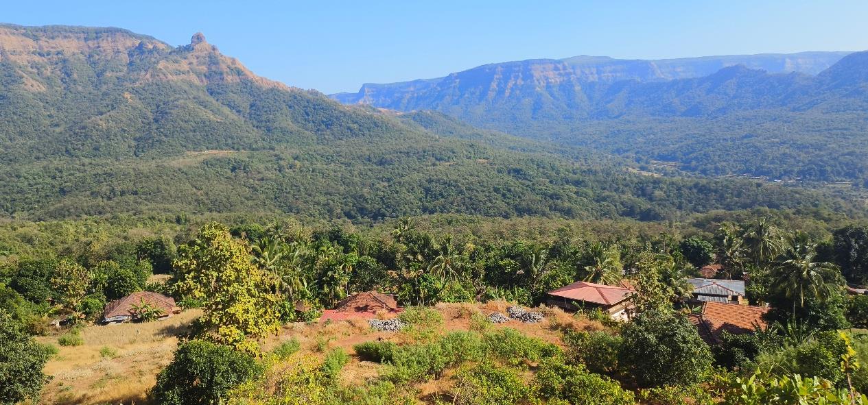
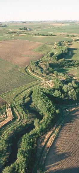
Img No. 03 Gothvewadi (A Village Prone to Landslide Risk in the Sahyadri Mountains)
Source: Author
Chapter 3:Assessment of Heavy Rainfall Patterns
Assessing heavy rainfall patterns is essential for understanding landslide-susceptible villages in the Sahyadri mountain ranges due to the direct correlation between rainfall dynamics and landslide occurrences. Heavy rainfall events play a significant role in triggering landslides by saturating the soil, increasing pore water pressure, and reducing slope stability. Therefore, analyzing rainfall patterns provides crucial insights into the frequency, intensity, and duration of precipitation events, which are pivotal factors influencing landslide susceptibility.
To conduct an assessment of heavy rainfall patterns, several key steps are involved:
Collection


Analysis
Analysis Rainfall Threshold Analysis
with Hydrology Data

Mapping
1. Data Collection: Gather historical rainfall data from meteorological stations located within or in close proximity to the Sahyadri mountain ranges. This data should span multiple years to capture seasonal variations and long-term trends in rainfall patterns.
2. Spatial Analysis: Utilize Geographic Information Systems (GIS) to spatially analyze rainfall data and identify areas experiencing high-intensity rainfall events Overlay rainfall data with topographic maps to discern spatial patterns of rainfall distribution across the region
3. Temporal Analysis: Conduct temporal analysis of rainfall data to discern trends and patterns in the timing and frequency of heavy rainfall events. Identify seasons or periods characterized by increased rainfall intensity, which may coincide with heightened landslide susceptibility.
4. Rainfall Threshold Analysis: Determine rainfall thresholds associated with landslide initiation in the Sahyadri mountain ranges. Establish thresholds for rainfall intensity, duration, and antecedent moisture conditions that are indicative of landslide-triggering conditions
5. Integration with Hydrological Data: Integrate rainfall data with hydrological information, such as soil moisture levels and groundwater fluctuations, to assess the combined influence of rainfall and hydrological factors on landslide susceptibility.
6. Risk Mapping: Develop risk maps depicting areas of heightened landslide susceptibility based on the analysis of heavy rainfall patterns. These maps can guide land use planning, infrastructure development, and disaster risk reduction efforts in landslide-prone regions.
By comprehensively assessing heavy rainfall patterns, we can enhance our understanding of the factors contributing to landslide susceptibility in the Sahyadri mountain ranges. This knowledge is instrumental in developing proactive measures and effective mitigation strategies to mitigate the impacts of landslides on vulnerable communities and infrastructure.
Spatial
Temporal
Risk
10
Data
Integration
Over the years, rainfall levels in the Konkan region across the Sahyadri ranges have fluctuated significantly, impacting landslide susceptibility Recent shifts in rainfall patterns, marked by intensified and erratic events, have heightened the vulnerability of villages in the Sahyadri mountain ranges to landslides These changes underscore the urgency for robust assessment and mitigation measures. Integrating data on changing rainfall levels with comprehensive landslide susceptibility assessments enables adaptive risk management, fostering resilience in the face of evolving climatic conditions.
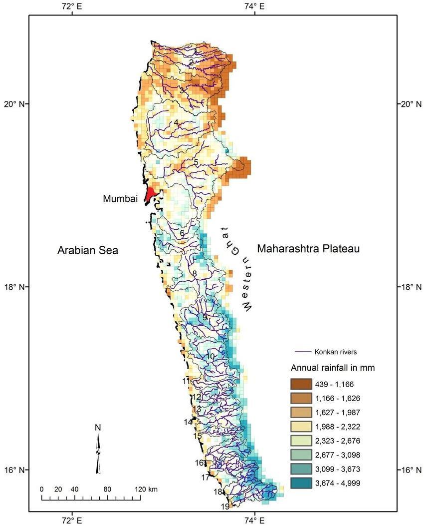
No. 04 Annual
Region Source: ResearchGate
Img
Rainfall in Konkan
Chapter 4: Monitoring Soil Water Saturation
Monitoring soil water saturation is crucial for landslide mitigation in villages prone to landslides in the Sahyadri mountain ranges. Here's how to do so without relying on high-tech equipment:


Observation by Farmers Crop Health Assessment Field Surveys

Marking Water Accumulation Points Improving Drainage
1. Observation by Farmers: Local farmers often possess invaluable knowledge of soil conditions, as they can observe changes in crop health due to water saturation
Utilize this expertise by engaging with farmers to identify areas where water accumulation occurs and soil saturation is likely
2. Crop Health Assessment: Monitor the health of crops and vegetation, as wilting or yellowing may indicate waterlogged soil. Identify areas where vegetation shows signs of stress or decline, as these can serve as indicators of potential landslide hazards.
3. Field Surveys: Conduct regular field surveys to visually inspect soil conditions, looking for signs of waterlogging such as standing water or muddy patches
Document areas prone to soil saturation and prioritize them for mitigation measures
4. Marking Water Accumulation Points: Use simple markers or flags to delineate areas where water accumulates and soil saturation occurs. This helps in spatially identifying vulnerable zones and facilitates targeted mitigation efforts
5. Improving Drainage: Once water accumulation points are identified, implement measures to improve drainage and redirect excess water flow. This could involve constructing swales, trenches, or channels to channel water away from vulnerable areas.
Relating this approach to the previous chapter on the Assessment of Heavy Rainfall Patterns, monitoring soil water saturation complements the understanding of rainfall dynamics. By correlating heavy rainfall events with observed soil saturation, villages can anticipate landslide risks and implement timely mitigation measures.
Furthermore, considering the presence of olivine in basaltic soils prevalent in the Sahyadri mountain ranges, it's essential to acknowledge its role in exacerbating soil erosion. While olivine itself may not be the primary cause of landslides, its contribution to soil breakdown can weaken slopes, making them more susceptible to landslides.
Therefore, integrating soil water saturation monitoring with proper land management strategies, including vegetation cover and erosion control measures, is crucial for mitigating landslide risks in these regions. This holistic approach, combined with hazard mapping in the next chapter, forms a comprehensive strategy for landslide mitigation in villages within the Sahyadri mountain ranges.
12
Chapter 5: Landslide and Mudslide Hazard Mapping
Landslide and mudslide hazard mapping on a micro (village) level is crucial for identifying landslide-prone villages in the Sahyadri mountain ranges and developing targeted strategies to enhance their resilience. Here's how to conduct this mapping process
Step 6
Consider Soil Type

Step 5
Identify Vulnerable Structures


1
Obtain Contour Map


Step 4
Mark Water Accumulation Areas
Landslide & Mudslide Hazard Mapping

Divide by Heights


Step 3
Identify Ridges and Valleys
1. Obtain Contour Map: Acquire a contour map of the village settlement from relevant authorities or conduct a survey to create one. This map depicts the elevation variations across the settlement, aiding in the identification of slopes and valleys.
2. Divide by Height: Divide the contour map into distinct elevation bands or height intervals, assigning each interval a unique color or shading according to a color legend. This facilitates visualizing the terrain's steepness and identifying potential landslide-prone areas
3. Identify Ridges and Valleys: On a micro level, identify ridges (elevated landforms) and valleys (low-lying areas) within the settlement. Valleys are particularly vulnerable to landslides due to water accumulation and soil saturation.
4. Mark Water Accumulation Areas: Locate areas within valleys where water accumulates and marks those prone to landslides. These areas are susceptible to soil saturation and increased landslide risks during heavy rainfall events.
5. Identify Vulnerable Structures: Mark areas with construction, rivers, streams, wells, and farmlands on the map Structures built in vulnerable areas or near water bodies are at increased risk of landslides.
6. Consider Soil Type: Understand the soil type of the settlement, especially if it contains olivine-rich basaltic soil, which can exacerbate erosion and landslide hazards. Additionally, areas near farmlands are prone to landslides due to soil disturbance from farming activities
7. Overlay Hazard Zones: Overlay the identified hazard zones, including water accumulation areas, vulnerable structures, and areas with loose soil, onto the contour map This creates a comprehensive hazard map highlighting the areas at risk of landslides and mudslides within the village settlement.
13
Step
01 02 03 04 05 06
Step2
In conclusion, conducting landslide and mudslide hazard mapping on a micro level is paramount for identifying vulnerable villages in the Sahyadri mountain ranges and devising tailored strategies to bolster their resilience. By utilizing contour maps and identifying key terrain features such as ridges, valleys, and water accumulation areas, communities can pinpoint areas prone to landslides and mudslides. Integrating factors like soil type, proximity to water bodies, and human activities such as construction and farming further refines the hazard mapping process, providing a comprehensive understanding of landslide risks within the village settlement. Moving forward, the next chapter on Soil Testing and Analysis plays a pivotal role in enhancing the effectiveness of landslide resilience strategies. By analyzing soil characteristics such as composition, texture, and permeability, communities can assess the stability of slopes and identify areas susceptible to erosion and landslides. Soil testing enables informed decision-making regarding land use planning, construction practices, and vegetation management, thereby contributing to the development of robust mitigation measures The insights gained from soil testing and analysis complement the findings of landslide hazard mapping, enabling villages in the Sahyadri mountain ranges to adopt proactive measures that mitigate the impacts of landslides and safeguard the well-being of their inhabitants.
14
Img No. 05 Settlement Level Hydrology Map
Source: Author
Chapter 6: Soil Testing andAnalysis
Soil testing and analysis are integral components of landslide mitigation guidelines for safeguarding villages in the Konkan region, particularly those situated at the base of the Sahyadri mountain ranges. Despite the predominant presence of metamorphic rock in the Konkan region, villages adjacent to the Sahyadri mountains are often characterized by basalt rock formations, giving rise to basaltic soil. Basaltic soil contains minerals such as olivine, which, while not the primary cause of landslides, can exacerbate soil erosion and increase landslide susceptibility. Therefore, understanding the composition and properties of the soil through testing and analysis is paramount for effective landslide mitigation strategies.
To conduct soil testing and analysis without relying on high-tech equipment, the following steps can be employed:
Field Tests
Soil Composition Visual Inspection
Infiltration Tests
pH Testing Consult Local Experts
1. Visual Inspection: Begin by visually inspecting the soil to assess its color, texture, and structure Basaltic soil is typically dark in color and may have a coarse texture due to the presence of mineral particles.
2. Soil Composition: Collect soil samples from various locations within the village settlement, including areas identified as potentially susceptible to landslides. Examine the composition of the soil, paying attention to the presence of minerals such as olivine, which may contribute to soil erosion
3. Field Tests: Perform simple field tests to assess soil properties such as permeability and stability. For example, the hand-texture method involves squeezing a handful of soil to determine its moisture content and cohesion.
4. Infiltration Test: Conduct an infiltration test to assess the soil's ability to absorb water Dig a hole in the soil, fill it with water, and measure the rate at which the water infiltrates into the soil. Slow infiltration rates may indicate poor drainage and increased landslide risk.
5. pH Testing: Use a simple pH testing kit to determine the acidity or alkalinity of the soil. Soil pH can affect the stability of slopes and the availability of nutrients for vegetation
6. Consult Local Experts: Engage with local experts, such as agricultural extension officers or geologists familiar with the region, to gain insights into soil characteristics and their implications for landslide susceptibility
By conducting soil testing and analysis using these low-tech methods, villages in the Konkan region can gather valuable information to inform landslide mitigation efforts. Understanding the properties and behavior of the soil enables communities to implement targeted measures such as erosion control, slope stabilization, and vegetation management, thereby reducing the risk of landslides and safeguarding the lives and livelihoods of residents.
15
Chapter 7: Implementation of Vegetative Strategies
Implementing vegetative strategies is vital for landslide treatment and mitigation by stabilizing slopes, reducing erosion, and bolstering resilience. These methods utilize vegetation to anchor soil, absorb moisture, and mitigate runoff, minimizing landslide hazards sustainably. Combining vegetative and structural techniques ensures comprehensive landslide mitigation, safeguarding communities and ecosystems effectively
The map illustrates vegetative strategies to be implemented in specific landslide risk zones identified at the regional level through analysis of the hydrology map discussed in the initial chapter.
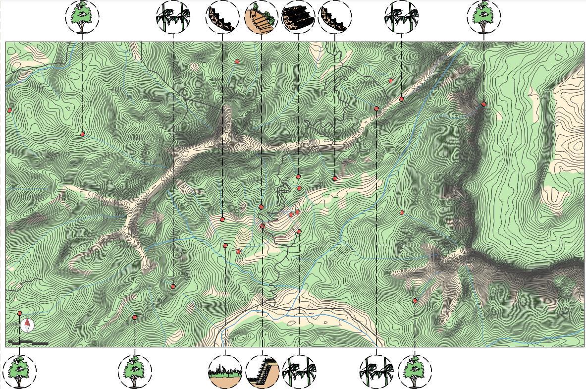
The illustration below outlines strategies derived from the hydrology map discussed in Chapter 5, tailored for implementation at the settlement level.
16
Img No. 06 Regional Level Vegetative Strategies
Source: Author
Img No. 07 Village Level Vegetative Strategies
Source: Author
The table below outlines the strategies for implementing vegetative measures along with their respective limitations.
Sr.
1. Grass Planting
2. Mulching for slope stabilization
1. Protects surface from rain by providing ground cover.
2. Enhance infiltration to lessen runoff.
3. Catch soil particles and strengthen slopes.
1. Protects soil from raindrop erosion, heat, frost, and wind.
2. Reduces evaporation thus conserves moisture.
3. Armors soil temporarily
Labor intensive. Only good for shallow small landslips.

Requires huge quantity of mulching material.
Labor intensive.
3. Bamboo Planting
1. Reinforces soil against erosion.
2. Provides excellent support to the slope if planted at the base / toe slope.
3. Reduces the velocity of run-off water.
4. Traps soil eroded from up slope.
5. Works as a fence.
4. Buffer Strip
1. Intercepts runoff and sediment from adjoining (up-slope) lands and reduce impact on downslope area from runoff and sediment
2. Protects adjoining land from bank erosion such as along the stream or lake or sea.
3. creates effective barrier to reduce impacts such as pollution
Nothing else can grow close to tall bamboo, mainly due to shading and nutrients and moisture competition. Bamboo seeds may not be available during need.
Difficult to establish in steep slopes. (>50 degrees)

No. Title Function
Limitations Image
17
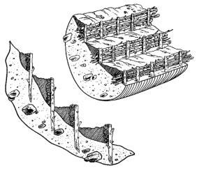
Chapter 8: Sustainable Retaining Wall
A sustainable retaining wall crafted with gabions, live tree branches, and thoughtful design not only fortifies landscapes against the threat of landslides but also enriches communities with vibrant open spaces. This innovative strategy merges ecological consciousness with practical infrastructure, offering multiple benefits beyond its primary function.
At its core, the sustainable retaining wall stands as a bulwark against erosion and landslides, safeguarding vulnerable terrain. Gabions, sturdy wire cages filled with rocks or stones, form the backbone of this structure, providing stability and support. Their porous nature facilitates water drainage, reducing hydrostatic pressure and minimizing the risk of soil instability. Live tree branches integrated into the gabion framework further enhance its eco-friendliness, promoting biodiversity and natural aesthetics. These branches not only beautify the wall but also contribute to soil stabilization through their root systems, bolstering its resilience against environmental forces.
Beyond its role in hazard mitigation, the sustainable retaining wall transcends conventional infrastructure by incorporating elements of community engagement and recreation. Open play areas for children foster a sense of belonging and encourage outdoor activities, promoting physical health and social interaction Likewise, designated community spaces serve as gathering points for residents, fostering bonds and strengthening the social fabric of neighborhoods Vegetation strategically incorporated into the wall not only beautifies the landscape but also enhances air quality, providing an oasis of greenery amidst urban environments
The process of creating such a multifaceted structure involves meticulous planning and collaboration between various stakeholders Here's a simplified outline of the construction process:

Site Assessment & Planning Material Selection Gabion Installation

Integration of Live Tree Branches Community Engagement & Amenities Vegetation & Landscaping

1. Site Assessment and Planning: Conduct a comprehensive assessment of the terrain to identify areas prone to landslides and erosion. Develop a detailed plan that integrates the retaining wall with existing landscape features and community needs.
2. Material Selection: Choose high-quality gabions, ensuring they meet structural requirements and environmental standards Select live tree branches suitable for the local climate and soil conditions, prioritizing species with strong root systems and aesthetic appeal
3. Gabion Installation: Begin by preparing the foundation for the retaining wall, ensuring proper drainage and stability. Assemble the gabions according to the design specifications, filling them with durable rocks or stones Stack the gabions systematically, reinforcing key sections as necessary to withstand lateral pressure.
18
4. Integration of Live Tree Branches: Incorporate live tree branches into the gabion framework, weaving them securely to create a cohesive structure. Ensure proper spacing and distribution to maximize their stabilizing effects and aesthetic impact.
5. Community Engagement and Amenities: Integrate open play areas and community spaces into the design, considering factors such as accessibility, safety, and functionality. Involve local residents in the planning process to ensure their needs and preferences are addressed.
6. Vegetation and Landscaping: Plant vegetation along the retaining wall, selecting species that thrive in the local climate and complement the surrounding environment. Implement sustainable landscaping practices, such as mulching and drip irrigation, to promote plant health and conserve water
7. Monitoring and Maintenance: Regularly monitor the retaining wall for signs of erosion, settlement, or structural damage Implement proactive maintenance measures, such as vegetation management and debris removal, to preserve its integrity and effectiveness over time
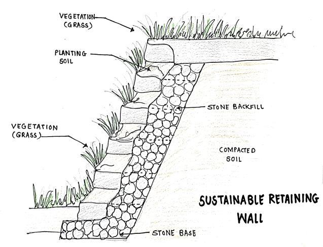
By embracing the principles of sustainability and community-centric design, a sustainable retaining wall transcends its traditional role as a mere structural element, becoming a symbol of resilience, harmony, and inclusivity within the built environment.
19
Img No. 08
Sustainable
Retaining Wall Source: Author
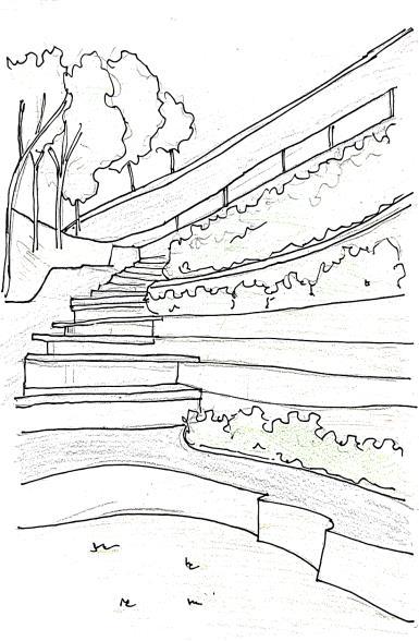
Img No. 10 Conceptual Sustainable Retaining Wall with Community Spaces Source: Author
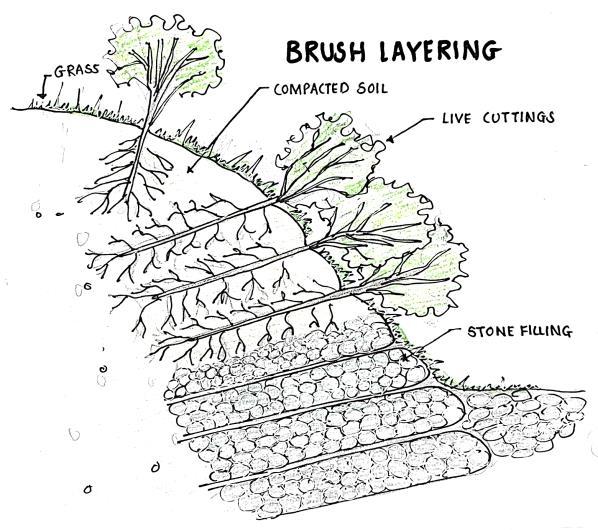
Img No. 09 Brush Layering Source: Author
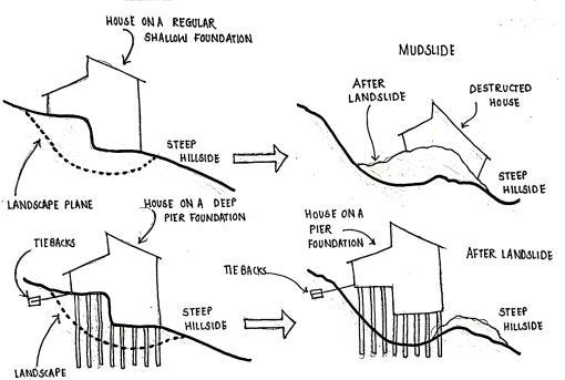
Slope Stabilization Techniques:
In order to stabilize slopes against landslides, a variety of techniques such as nails, anchors, gabion or retaining walls, and slope reinforcement techniques are typically used.
Sr.
1. Watlin g Catches debris moving down the slope Reinforces the slope Modifies the slope
1. Stakes 1 m long, 8-10 cm diameter, and 50 cm long, 68 cm diameter. Sharpen all stakes at the bottom.
2. Woody cuttings of long and flexible plants which root easily (more than 150 cm long and 3 – 5 cm diameter)
3. If sprouting materials are not available, material like bamboo could be used.
4. Jute or coir string or wire to bind

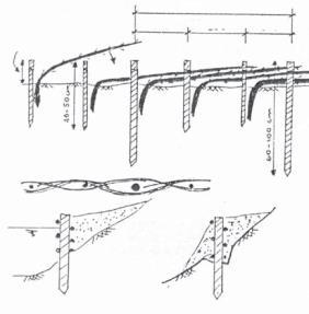
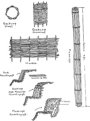
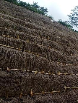
Wattling, a traditional technique, serves as a sustainable alternative to costly retaining walls for slope stabilization It involves weaving branches or twigs into a lattice structure, which is then filled with soil or vegetation. This method not only reinforces slopes but also promotes soil retention and minimizes erosion. By utilizing locally available materials and simple construction techniques, wattling offers a cost-effective solution for stabilizing slopes in areas where conventional retaining walls may be financially prohibitive.
20
Function Material Image
No. Title
Chapter 9: Settlement Mapping & Vulnerability Assessment
Settlement mapping and vulnerability assessment on a micro level are crucial for understanding the specific risks and vulnerabilities faced by communities in landslideprone areas. By conducting such assessments, communities can identify vulnerable areas within settlements, assess the potential impact of landslides, and develop targeted mitigation and preparedness strategies. Here's why settlement mapping and vulnerability assessment are important, along with steps on how to conduct them:
1.Localized Risk Identification: Settlement mapping enables the identification of specific areas within a community that are vulnerable to landslides This includes areas with steep slopes, areas near water bodies, or locations with poor soil stability. By pinpointing these areas, communities can prioritize mitigation efforts and allocate resources effectively.
2.Community Engagement: Involving local residents in the mapping and assessment process fosters community awareness and ownership of landslide risks Community members can provide valuable insights into local hazards and vulnerabilities, contributing to a more comprehensive assessment.
3.Tailored Mitigation Strategies: Vulnerability assessment helps tailor mitigation strategies to address the unique challenges faced by each settlement. This may include implementing vegetative measures, improving drainage systems, or relocating vulnerable infrastructure away from high-risk areas.
4.Emergency Preparedness: Understanding settlement vulnerabilities allows communities to develop emergency response plans and evacuation procedures By identifying evacuation routes, safe shelters, and vulnerable populations, communities can better prepare for landslide events and minimize the impact on lives and property
To conduct settlement mapping and vulnerability assessment on a micro level, follow these steps:
1.Gather Data: Collect relevant data, including topographic maps, land use records, historical landslide data, and community input.
2.Identify Vulnerable Areas: Use mapping tools or conduct field surveys to identify areas within the settlement that are susceptible to landslides This may include steep slopes, areas with poor drainage, or locations near rivers or streams.
3.Assess Infrastructure: Evaluate the vulnerability of critical infrastructure such as roads, bridges, schools, and healthcare facilities to landslides Consider factors such as proximity to landslide-prone areas and structural integrity.
4.Engage Community: Involve local residents in the assessment process to gather firsthand knowledge of local hazards and vulnerabilities. Conduct community meetings or workshops to raise awareness and solicit input.
5.Analyze Risks: Assess the potential impact of landslides on lives, property, and infrastructure within the settlement. Consider factors such as population density, building density, and socioeconomic vulnerability.
6.Develop Mitigation Strategies: Based on the assessment findings, develop tailored mitigation strategies to address identified vulnerabilities. This may include implementing structural measures, land use planning, or community education
21
7. Continual Monitoring and Evaluation: Regularly monitor and evaluate the effectiveness of mitigation measures and update vulnerability assessments as needed Stay engaged with the community to ensure ongoing awareness and preparedness.
By conducting settlement mapping and vulnerability assessment on a micro level, communities can proactively identify and address landslide risks, ultimately enhancing their resilience to these natural hazards.
Source: Author
Source: Author
Source: Author
Source: Author
Source: Author
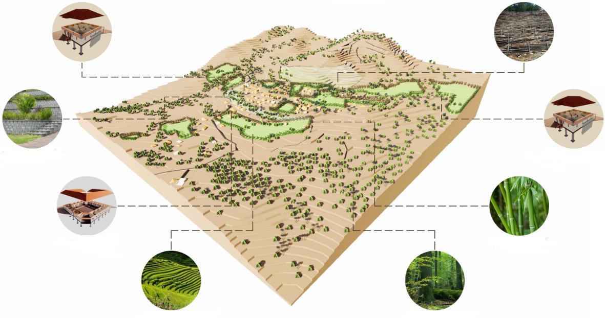
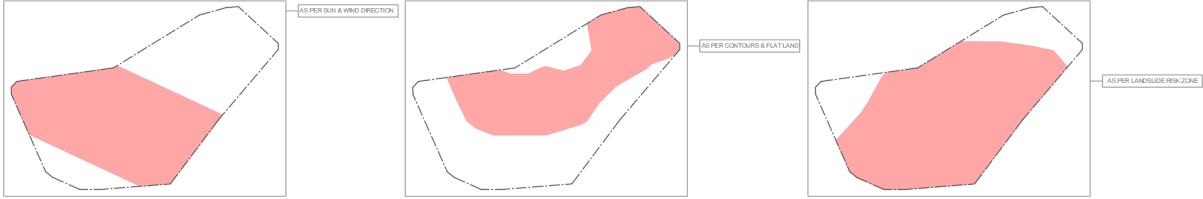
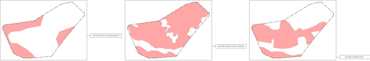
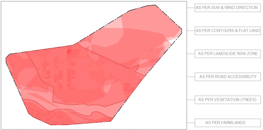
The maps above offer a comprehensive view of settlement's buildable space, integrating factors like sun and wind direction, topographic contours, flat land availability, landslide risk zones, road accessibility, vegetation cover, and farmlands. This integration optimizes land use planning and boosts resilience against landslides The combined map below highlights a safe buildable space, consolidating insights from the individual maps
Settlement mapping and vulnerability assessment empower communities to address landslide risks, safeguarding lives, property, and infrastructure Collaboration fosters sustainable development and resilience. Continuous monitoring ensures effective mitigation in evolving conditions, emphasizing ongoing engagement and preparedness in landslide-prone areas.
22
Img No. 12 As Per Contours
Img No. 13 As Per Landslide Risk Zone
Source: Author
Img No. 14 As Per Road Accessibility
Img No. 15 As Per Vegetation
Img No. 16 As Per Farmlands
Img No. 11 As Per Sun & Wind
Img No. 17 Buildable Space According to all the above Maps Source: Author
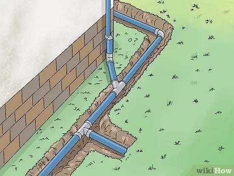
Chapter 10: Drainage System Mapping
Drainage system mapping on a micro level is crucial for effective landslide mitigation as it provides insights into the flow of water within a village settlement, helping to identify areas prone to soil saturation and landslide hazards. By understanding the drainage patterns and vulnerabilities, communities can implement targeted measures to improve drainage, reduce water accumulation, and mitigate the risk of landslides. Furthermore, drainage system mapping enables the identification of natural and manmade drainage features, such as streams, culverts, and ditches, which can be optimized or maintained to enhance slope stability and resilience
To conduct drainage system mapping without high-tech equipment, communities can employ simple yet effective methods:
Field Surveys: Conduct field surveys to visually inspect the terrain and identify natural drainage features such as streams, gullies, and depressions. Walk the settlement and observe how water flows during rainfall events to delineate drainage pathways.
Topographic Maps: Utilize existing topographic maps or create rudimentary sketches of the village settlement to map out elevation contours and identify potential drainage channels and low-lying areas prone to water accumulation.
Community Engagement: Engage with local residents and farmers who possess firsthand knowledge of the settlement's drainage patterns Gather insights from their observations and experiences to supplement the mapping process.
Marker Placement: Use simple markers or flags to denote key drainage features, including areas of water accumulation, natural drainage channels, and man-made drainage structures such as culverts and ditches.
Manual Measurements: Take manual measurements of distances and elevations using basic tools such as measuring tapes and hand-held altimeters This information helps in accurately mapping the terrain and identifying potential drainage issues.
Documentation: Document the findings of the drainage system mapping exercise, including the location of drainage features, observed drainage patterns, and areas prone to soil saturation and water accumulation.
By conducting drainage system mapping using these low-tech methods, communities can gain valuable insights into the drainage dynamics of their village settlement This information serves as a foundation for implementing targeted drainage improvement measures, such as clearing blocked channels, constructing new drainage structures, or enhancing natural drainage pathways, ultimately reducing the risk of landslides and enhancing the resilience of the community to rainfall-induced hazards.
23
Img No. 18 Drainage Strategies Source: Author
Chapter 11: Material Testing for Lightweight and Sustainable Solutions
Material testing for lightweight and sustainable solutions is crucial for ensuring the structural integrity and resilience of construction in landslide-prone areas By utilizing local materials and implementing innovative building techniques, communities can minimize costs while maximizing safety and durability The importance of material testing lies in verifying the suitability and performance of these materials under varying conditions, including the potential impact of landslides and heavy rainfall
Incorporating only local materials ensures affordability and accessibility, making construction feasible for communities in landslide-prone regions. For instance, utilizing thick and sturdy materials like laterite stone for outer walls provides strength to withstand external forces, such as those exerted during a landslide event Inner walls constructed with lightweight materials such as bamboo covered in cement mortar offer additional protection while minimizing the risk of structural collapse Pier foundation, connecting the base of the foundation, enhances stability and distributes the load evenly, further fortifying the structure against landslides
To conduct material testing for lightweight and sustainable solutions, communities can employ various methods. This includes subjecting materials to stress tests to evaluate their strength and durability, assessing their performance under simulated landslide conditions, and analyzing their resistance to heavy rainfall. Additionally, field testing can be conducted to observe how materials behave in real-life scenarios and to validate their suitability for construction in landslide-prone areas. By rigorously testing and evaluating materials, communities can ensure the safety and resilience of their structures, mitigating the risks posed by landslides and enhancing overall disaster preparedness.

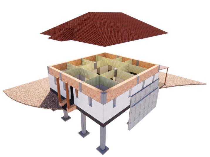
This is an example of material testing conducted on bamboo for inner walls within a small prototype structure. When bamboo was covered in mud mortar, cracks appeared in the walls, indicating a lack of durability and resilience As a result, bamboo covered in cement mortar emerged as a superior option, offering enhanced strength and stability for inner wall construction
24
Img No. 19 Bamboo wall Unsuccessful Prototype
Source:
Author
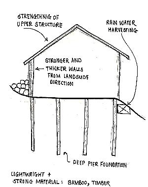
Chapter 12: Integration of Structural Resilience Strategies
Integration of structural resilience strategies is paramount for mitigating landslide risks and ensuring the durability of infrastructure in vulnerable areas By incorporating various measures and techniques into construction practices, communities can enhance their resilience to landslides and other natural hazards
Here's how to integrate structural resilience strategies effectively:
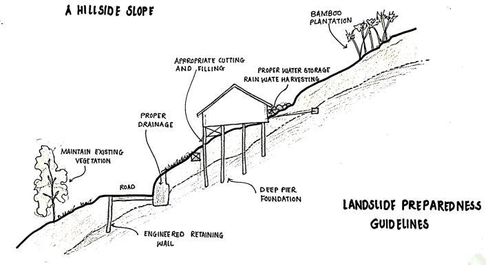
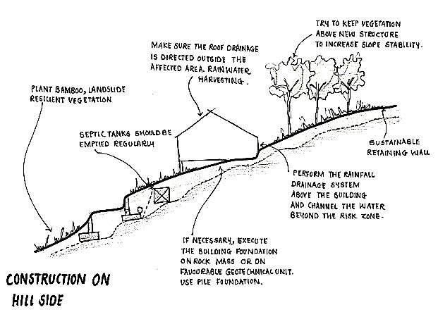
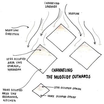
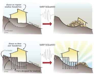
1. Orientation and Foundation: Orienting houses at a 45-degree angle to redirect landslide flow and implementing pier foundation connected to each other for stability
2. Lightweight Walls: Constructing bamboo walls for lightweight yet sturdy structures, minimizing the impact of landslides.
3. Improvements in Land Usage: Implementing agroforestry, conservation plantations, and grass plantations to enhance soil stability and reduce erosion.
4. Drainage Management: Installing surface and subsurface drainage systems to prevent runoff from feeding into landslides and draining surplus water Techniques include construction of diversion waterways and gravel-filled subsurface drainage trenches
5. Surface Erosion Control: Utilizing erosion control methods such as jute netting, mulching, and planting grass or tree saplings to mitigate surface erosion.
6. Erosion Management in Rills and Gullies: Employing techniques like fascine, contour grass planting, and check dams to manage erosion in rills and gullies effectively
7. Slope Stabilization: Implementing crib walls, retaining walls, and toe walls to prevent slope failure caused by cutting or steep slopes.
8. Deep-Seated Landslide Mitigation: Bolting the rock bed of deep-seated landslides and excavating to remove rock and soil from the head of the slide to minimize driving force.
9. Building Components: Ensuring the strength of buildings during landslide incidents by considering factors such as foundation, walls, roof, and drainage system. Following design and construction fundamental checklists is essential for minimizing structural destruction.
Author
By integrating these structural resilience strategies into construction practices, communities can build infrastructure that is more resilient to landslides and other geological hazards, safeguarding lives and property effectively
25
Img No. 20 Construction Strategies for building on Slope Source:
The table given below shows what parameters one should look for while construction of the building.


In conclusion, adopting house-level construction strategies is essential for mitigating landslide risks and ensuring the safety of residents. By implementing these measures, households can fortify their structures against the destructive forces of landslides, contributing to overall community resilience. As communities continue to confront the threat of geological hazards, prioritizing resilient construction practices at the household level remains imperative for building safer and more sustainable living environments
26