

FOLIO

Selected Academic & Professional Works

Contents
M.Arch Final Thesis Studio
02 Decolonization of Urban Space
Seeking New Denition for Dhaka’s Urban Residential Neighbourhood through Critical Regionalism
05 Hope Is Good
M.Arch First Year Design Studio
Takhayal Ramallah 2070
B.Arch Final Year Thesis
07 Karnaphuli Riverside Celebration Of A River To Inspire A City
09
B.Arch Fourth Year Design Studio
Visioning Sustainable village Study and Design of Ethnic Rural Settlement
11
13
Professional Architectural Work (BUILT)
bidyanondo sampriti anathalaya school
Exploring Vernacular Craftsmanship to Design an Elementary Children Space
Professional Architectural Work (AWARDED COMPETITION ENTRY)
Golpahar Mohashawshan Temple Complex
Spiritual Landmark x Urban Plaza
Decolonization of Urban Space
SEEKING NEW DEFINITION FOR DHAKA’S URBAN RESIDENTIAL NEIGHBOURHOOD THROUGH CRITICAL REGIONALISM
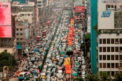
The con�nuous socio-economic transforma�on in Dhaka in the recent decades has created new economic classes and urban residen�al landscapes, where profit-oriented development has neglected the humane quali�es- aliena�ng people from each other in the process. This 'architecture of aliena�on' is contradic-tory to the historically prac�ced communal living culture in the region where shared collec�ve spaces and socio-spa�al hierarchy created resilient neighbourhoods. The current residen�al scenario in Dhaka is dominated by the tall apartments that are detached from the surrounding urban fabric, are mostly produced by copying western colonial scholarship and standards; which have failed in several ways to reflect the local climate, culture, and social pa�erns. The death of common collec�ve spaces and effec�ve communi�es resulted in more vulnerable urban popul-a�on and social stra�fica�on. It is high �me to rethink alterna�ve urbanism models with cri�cal evalua�on of local history and cultural lifestyle, and the upcoming urban challenges. There is an opening to explore how to bring back the lost intermediate spaces in our residen�al areas to recreate social cohesion and sustainable communi�es, preven�ng the consistent social fragmenta�on and economic pressure on marginalized people. In my postgraduate thesis, I discussed the current urban reality of Dhaka and the regional historic se�lement pa�erns, to examine the possibili�es of reintroducing social reproduc�on as the key ingredient of the urban residen�al place-making process. In the design phase, I have made an a�empt to face the challenge by designing policy and codes to define a future of sustainable residen�al neighbour-hood crea�on in Dhaka.
Formal Informal
40% of total GDP in Dhaka
47,400/sqkm popula�on density
only 7% of total housing stock is public
Govt. Employee Housing
Public Housing Private Housing
Serviced Plots for Upper Economy Class
Lower Economy Class Mass Housing
Housing Co-operatives
Real Estate Development
Serviced Plots for High Income People
Owned House
Housing by Tenancy Apartments
Housing by Mess (Barrack houses)
Slums
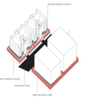
Dark Ground Floor Vehicular road
Unused setback spaces
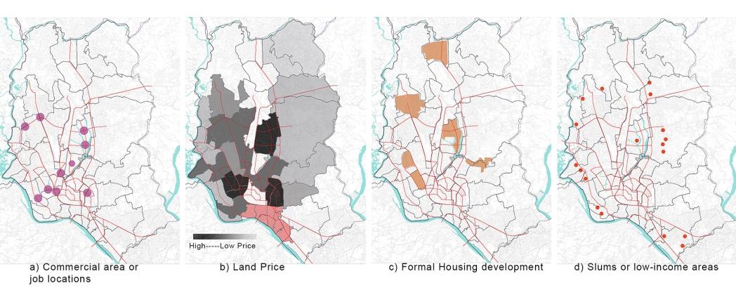
Compara�ve maps show how the core areas of the city are expensive and low income people are pushed to the periphery
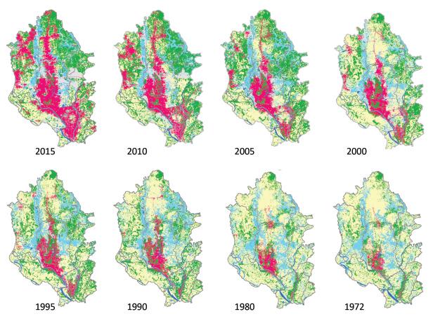
Maps show expansion of built area and diminishing Green/Wetland
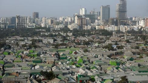
 The Unequal City Skyline shows slums and luxurious areas side by side
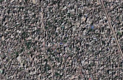
A haphazard congested unplanned informal Residen�al Area Traffic jams and high pollu�on level are regular suffering
The Unequal City Skyline shows slums and luxurious areas side by side
A haphazard congested unplanned informal Residen�al Area Traffic jams and high pollu�on level are regular suffering
.Arch Final Thesis Studio
M
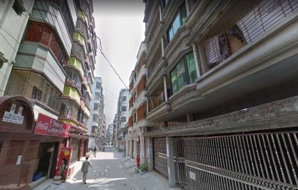
Photo showing newly developed area with narrow dead vehicular street,boundary walls
2
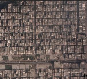
Google aerial view of U�ara Housing Area, one formal developed housing
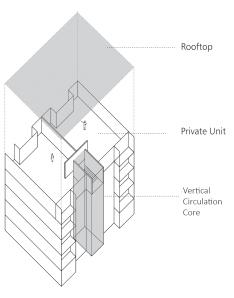
Core
High Boundary Wall Rooftop Individual Unit Vertical Circulation
Rigid formal development produces unused/non-interac�ve spaces
Key Housing Typology in Dhaka
Built Area Waterbody Wet Land
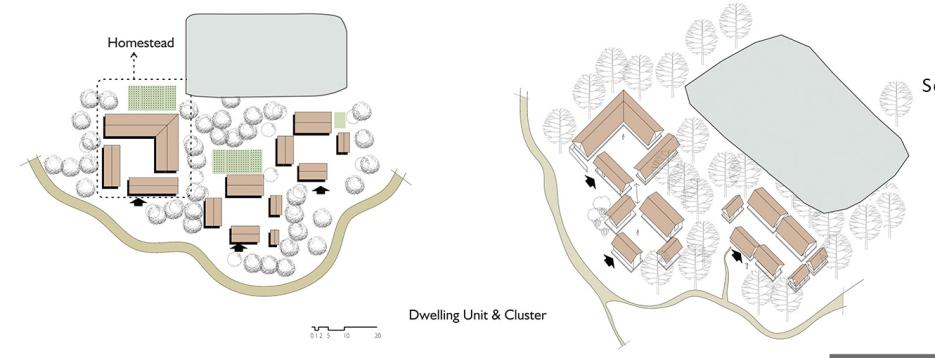
The Tradi�onal Rural Living in Bengal
One can find four major hierarchical elements for proper livable se�lements in tradi�onal rural se�lement; star�ng from the private house, secondly the in�mate contact spaces, thirdly the neighbourhood mee�ng places and lastly the larger scale principal urban area like Bazar (marketplace) or open field. In our tropical hot-humid climate many of the daily life chores and mee�ngs happen in open or semi-open shaded spaces. The in-between spaces of in�mate contact, the shaded gathering places have always been a major considera�on in communal rural neighbourhoods.
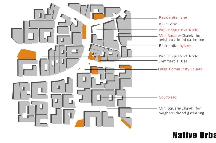
The Indigenous Urban Sprawl: Old Dhaka
The na�ve urban living example can be found in the older parts of Dhaka, famously known as 'Puran Dhaka', where an indigenous urban living pa�ern grew with �me. The indigenous urban fabric suggests it adapted and transformed into a denser urban spa�al pa�ern from rural se�lement pa�erns. Low height mul�-storied houses are generally owner occupied, home to an extended joint family where people from three genera�ons live together.
The socio-spa�al hierarchy and closely bonded community find their socio-spa�al hierarchy in the sequence of spaces: private house - bylanes - lanes - mini gathering spaces in the nodes (Morh) - Larger gathering spaces (Chawk) - major market street as the axial spine. The narrow lanes are vibrant with street life and the shops, making it what Oscar Newman said a 'Defensible space' (Newman, 1996).
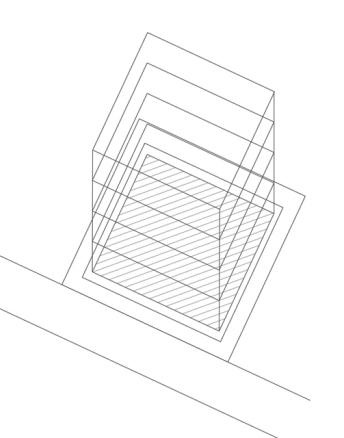
Existing Building Codes
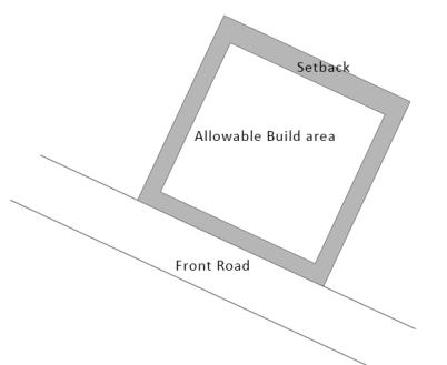
Setback Rule: This is rule which governs the minimum setback spaces for each plot, where the plot owner in no way build. This is to ensure that the built form leaves a minimal space from the surrounding built form or plot.
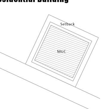
Maximum Ground Coverage (MGC):
This rule defines the maximum built area, or in other words the maximum floor area. This is generally less than the space that is le� a�er leaving setback, unless the plot is very small(less than 150 sqm).
As an example, for a 300 sqm site MGC is 62.5 %.
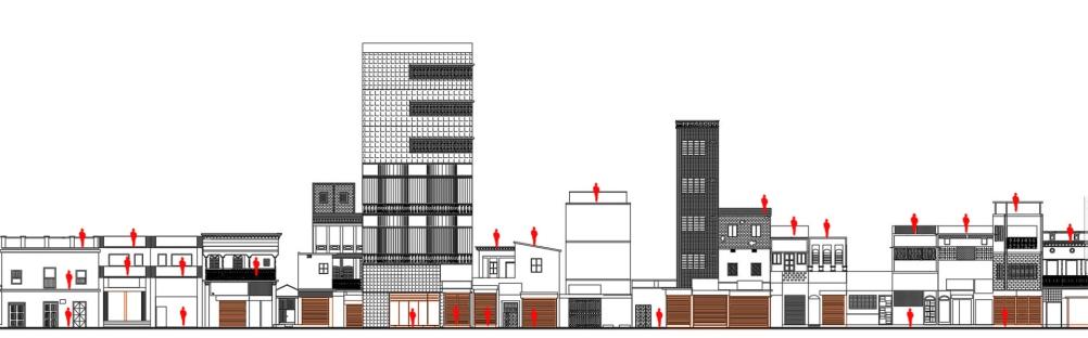
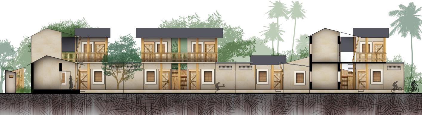
Street Sec�on showing lowrise, compact, in�mate se�ng of Old Dhaka; with interac�ve roo�op, terraces, and street level
Floor Area Ra�o (FAR):
This rule defines the number of floors. It is generally a quo�ent. As an example, for a 300 sqm site FAR is 3.50. That means maximum floor space allowed to build will be= Land Area x Far
= 300 x 3.5
=1050 sq m
So if anybody uses MGC as floor size, the number of floors will be = 1050/187.5 = 5.6 floors
Privacy based zoning and spa�al arrangement in different house types
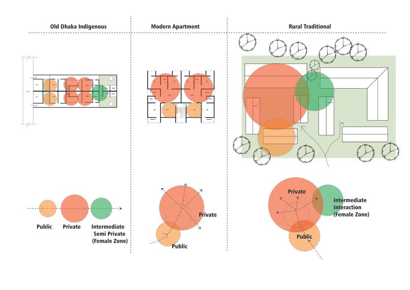 Spa�al Hierarchy in Old Dhaka Neighbourhood
3
Spa�al Hierarchy: Rural Se�lement
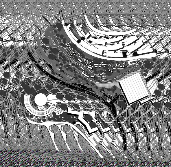
Design Development:
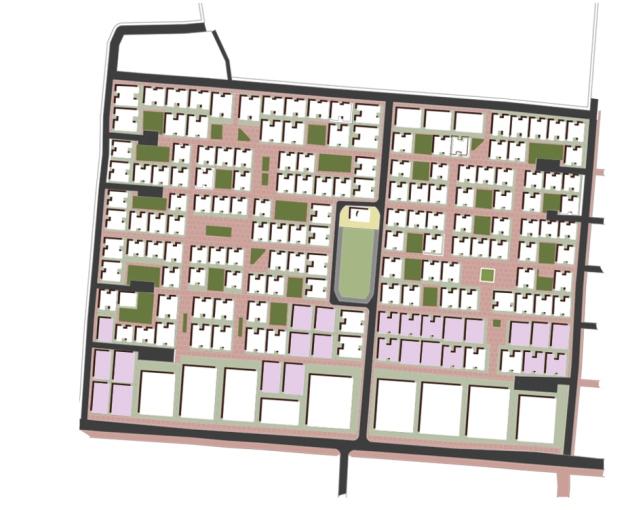
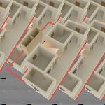
The selected site for design interven�on was ‘A�ab Nagar Housing Project, where real estate group already sand infilled the land and built the roads and some of housing block are completely sold out and built.
The design started with the exis�ng infrastructure situa�on and the a�empt was to improvise the housing blocks that are s�ll not sold out. Re-thinking of exis�ng building codes and implying them to make a be�er housing condi�on that helps to grow a stronger community with customized economic opportunity was the design concept.
Mini-square inside Housing area
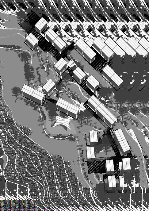
 Visualization:
Housing Block Plan
Visualization:
Housing Block Plan
4
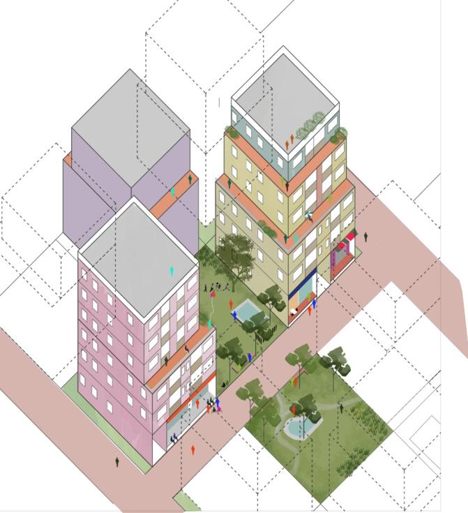
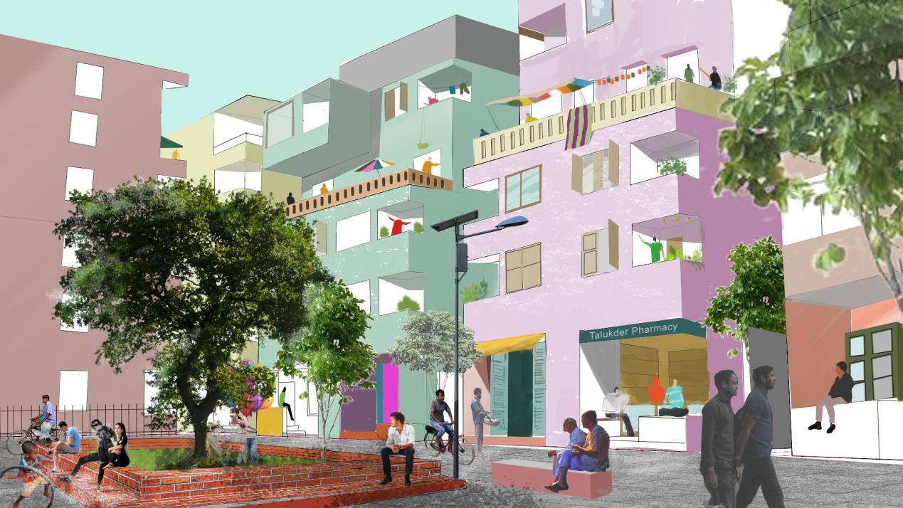
Axonometric view showing residen�al yards, terraces and street life
Hope Is Good
TAKHAYAL RAMALLAH 2070
This Studio was focused on cri�cally re-thinking city- and place-making,and processes of producing socio-poli�cally symbolic spaces. Developed designs were done to work through scenarios for a radical reconfigura�on of exis�ng reali�es in the city of Ramallah, through re-imagining the rela�onship between subject, �me and space.
We plan and design ci�es while we assume a moment of rupture (e.g. earthquake, flood)as extraordinary, excep�onal. But what if we start looking at moments of rupture as periodic, inherent to the system, and therefore think of possibili�es and alterna�ves in producing the ci�es of tomorrow around such moments?.... That said, this is what theinsurance system is built on, and is a founda�onal tool of neoliberal capitalism, and therewith, contemporary city-making.
In this studio we conducted some short readings, research and watched short films to develop an analysis, and therefrom imaginary scenarios for how the city of Ramallah could look like in the futuree.g. in 2046 or 2084. Scenarios were build on a set of assump�ons that were worked in the studio, and centralised the goal of climatechange adapta�on. We worked from the exis�ng reali�es to produce futuris�c, specula�ve, and wildly imagina�ve proposals.
Idea of future city
foci / ASSUMPTIONS / targets for 2070
Economically
- Need to break economic dependency by crea�ng alterna�ve forms of civic economies
- Need to create measures to protect against colonial mechanism, and Disaster Capitalism
- Think of poten�al of circular economy and loca�onal recycling of resources with food security
Socially
- Lack of Social Infrastructure and maldistribu�on >> Improve availability and accessibility
- Otherness and fragmenta�on – Improve socialisa�on possibili�es in everyday city spaces
Environmentally
- Re-think infrastructures to cope with climate change and issues of disaster(flooding) risk reduc�on.
- Create infrastructures that provide be�er and just access to basic resources (water, electricity).
Poli�cally
- Emergencies and herbicide >> normalise 'uncertainty' in urban planning discourses.
- A changed percep�on on urban land ownership enabling commoning / collec�vising ownership
Spa�ally
- Planning new neighbourhoods to have a density of 150 Persons / Hectar
- Produc�ve ci�es + the need for hybrid spaces to foster diversity and survive uncertain�es
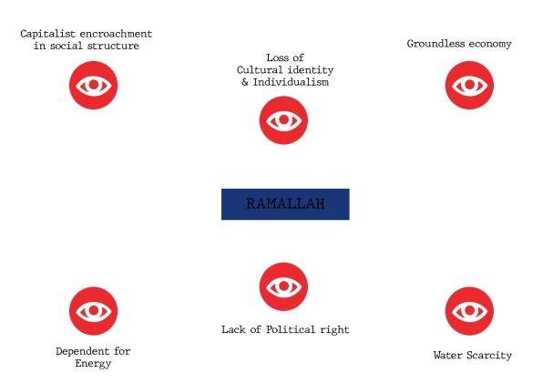
Challenges for Ramallah
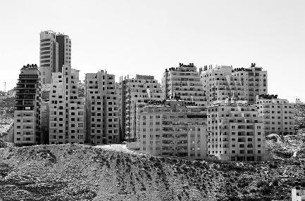
Self-sufficient


highrise
destroying community Housing
not respect local culture and living
Unplanned
development
development that does
Timeline The Unrest The New Formation & Planning Building of Infrasturces
and disparity ge�ng higher than ever A protest from the mass and students
of exis�ng Authori�es and a new mass governance introduced Forma�on of new economic strategies
budget on educa�on and research
planning with community crea�on and energy efficiency Dedicated farming areas across valley
Cra�s sector Biomass and research areas for materials and energy
vehicular movement and conges�on A city with more sustainable socio-economic features Carefully planned network of public places The Unrest The New Formation & Planning Building of Infrasturces 2020-2035 2035-2050 2050-2070
The Site Surrounding with the valley
Scarcity
Collapse
More
Residen�al
Priori�ze
Less
communi�es connected by cultural corridors and Public spaces.
and in�mate Communi�es designed for child-friendly spaces.
efforts on educa�on and research
city areas for Renewable energy produc�on and research
typologies based on efficiency and needs, wireless monitoring of energy use
Reuse & Rainwater Harves�ng
Stronger
Maximum
Dedicated
Building
Recycle,
M. Arch First Year Design Studio
5
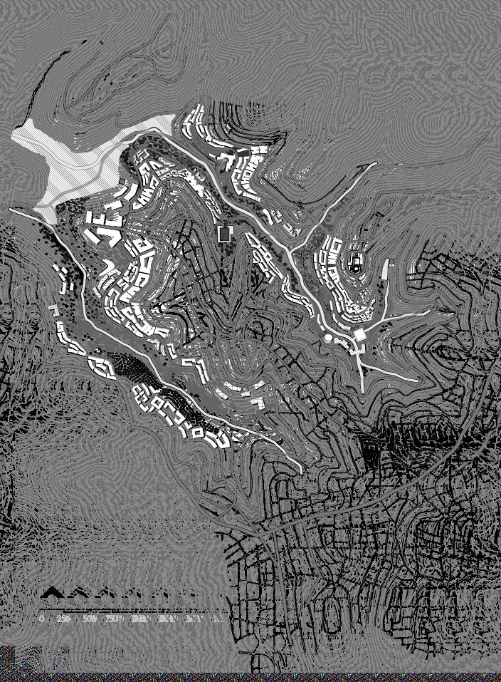
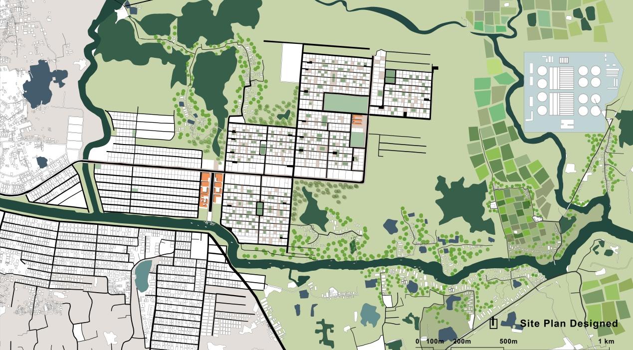
Site Plan
Top of hills preserved for wind power generation
Key Zoning Ideas
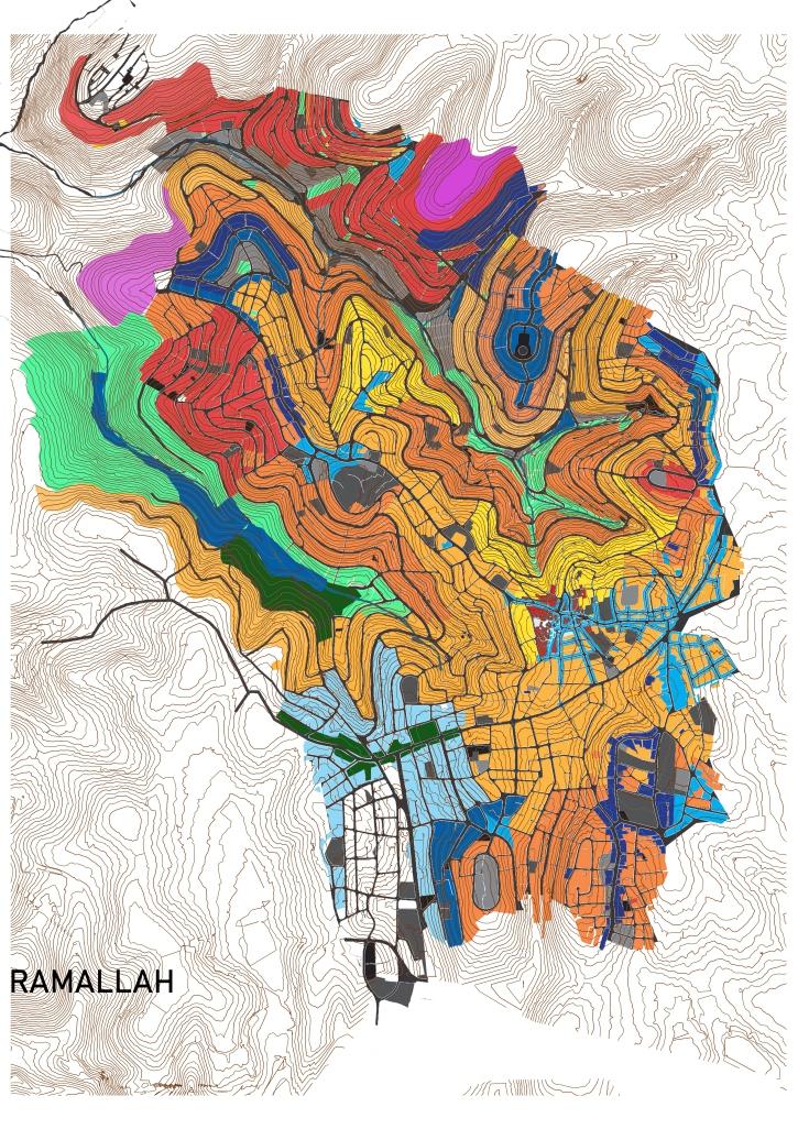
Design Concept
“If your plan for one year, plant rice. If your plan is for 10 years, plant trees. If your plan is for 100 years, educate children.”
-Confucius
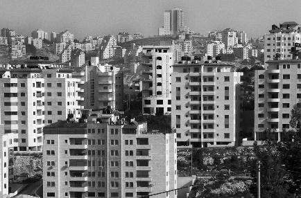
Ramallah, the de-facto capital of Pales�ne needs to make its way out from the ‘Consump�on-heavy’ and ‘Class-driven’ urban landscape it has now. With no proper poli�cal rights, not even rights on their own land and movement, it is difficult to see light at the end of the tunnel. But when I am asked to imagine, I can not lose hope, I imagine an uprise to upside down the corrupted authority, and people invest all their resources and efforts for a be�er future. Build great communi�es, be strategic on energy use and produce, design a city for kids. So that these kids can change the socio-economic scenario in future, can fight for the long cherished sovereignty, break Israeli chains with innova�ve approach.
Proposed Master Plan
agricultural
Preserved land for
production
& agricultural housing on the outskirt of city
0 250 500 750 1km Community Center Field+ Fitness center Local Market Public Park Central Water reserve + Waste Water treatment Cinema+ Galleries Agricultural Research Material + Energy Research Biomass Plant Local market + Community Center Olive Plantation Craft Zone (Weaving+ Olivewood craft)
New craftsman
Opening up valleyside area for social housing and educational facilities
Zoom in 1 Zoom in 3 Zoom in 2 Authentic Palestine Food Open to sky Coffe shop Weaving workshop A Playspace Café with Internet? Zoom in 3
corridor Open Amphi Shopping Area Public places Cinema + Gallery 0 10 20 50 Parking Cycle Pedestrian way
Axonometric
View of the cultural
Seasonal agriculture on at valley Public Park High rise zone Low rise housing Biomass & Research Craft (Housing+Workshop+ Sell) Educational institution 6
Karnaphuli Riverside
CELEBRATION OF A RIVER TO INSPIRE A CITY
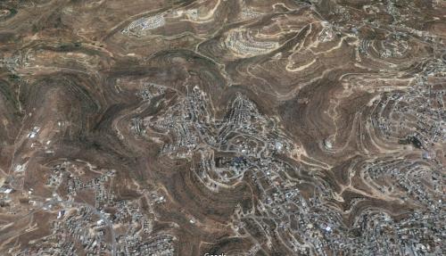
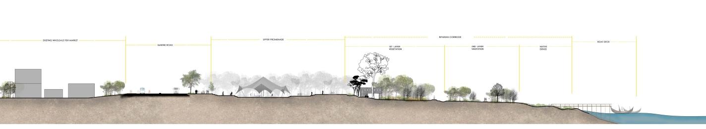
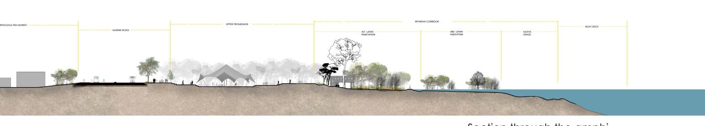
The river Karnaphuli is one of the important Trans-boundary river systems in the South Asia. Origina�ng from the Lushai hill in Mizoram, India, it flows through Chi�agong Hill Tracts and Chi�agong into the Bay of Bengal. The mouth of the river hosts Chi�agong seaport, the main port of Bangladesh. The Chi�agong city has been developed on the west bank of the Karnaphuli River.
Karnaphuli was always an integral part and cultural backdrop for the city. Oldest locali�es and communi�es grew along the river. Many people’s livelihood are s�ll related to the river.
At present, the river itself became inaccessible to the majority of the city’s residents. Becauseof illegal private ownership of some riverside land and the informal se�lements, there are few public access points to the river. The River bank, between the port and Shah Amanat bridge has been encroached by individuals and groups for residen�al and industrial use. Pollu�on is caused by dumping of solid waste by adjacent land users and also through oil spills from country boats. Li�le or zero awareness about the importance of water channels connected to the river made them dirty and narrow. The city, needless to say, is suffering fromunplanned urbaniza�on and lack of proper public place/open spaces.
Therefore, I decided to choose a 2 km stretch from the con�nuous riverbank beside the city. That par�cular site was chosen for there live the oldest urban locali�es, who have some emo�onal and cultural connec�on with the river, also a new Marine road was just built along the river crea�ng some poten�al land pieces beside river to be excellent public places.
River health
-Dredging
-Waste treatment
-Eviction of illegal structures
-Urban river beach
Shrubs and herbs
Riparian vegetation
Birds Playground
-Vetiver grasses
-Boats -Open play space
at dry season
-Brick pave
-Riverview -River edge protection
Landscape
-Defining river edge
-Riverbank protection
-Planned riparian vegetation
Infrastructure -Recreation & Entertainment facilities
-Safety & security
Big trees
Local trees
Relaxing, calm walkway
Soft pave
Seating
Shaded green
1st level vegetation
Relax and rest
Upper promenade
-continuous pedestrian
-Street shops
-Shading trees
Upper promenade
-Food court
-Entertainment
Marine Road
Urban Issue
-Relive the ghats
-Improve connectivity
-Protecting natural green & waterbodies
Green slope
Boat gallery Riverside pave View deck
Shading trees
-Pedestrian
-Cycle track
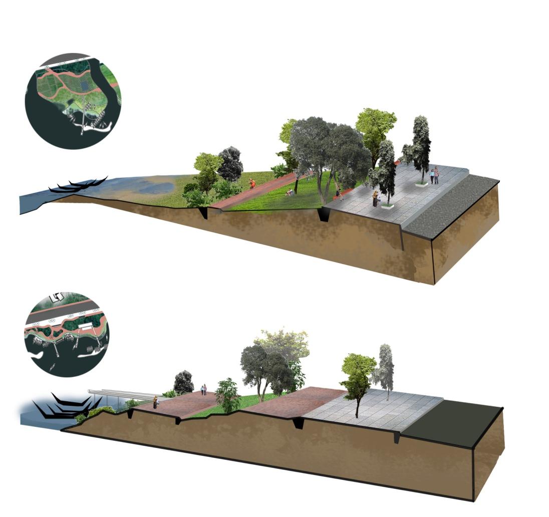
Waterfront designing should take into account seasonal changes. Different scenarios and ac�vi�es are designed for summer/rainy/winter season.
The low wetland area will help building a resistance against flood, using and retaining the extra water. On dry days, this lower spaces along river will work as green urban parks and play fields, even event space.
Sec�on through the road, site and river
Winter high water scenario
Sec�on through the road, site and river
Monsoon flood scenario
City area Marine road Upper promenade Riparian vegetation zone Wetland
7
Expansion of city Chi�agong area with �me, origina�ng from riverside, expanding inwards.
Marine road Upper promenade Riparian vegetation zone Wetland flooded Native Grass Fishery zone
B. Arch Final Year Thesis
RECREATION & TOURISM
Local Boat display
Gallery Info Center
Riverside walk Viewing deck Ghats
COMMUNITY FUNCTIONS
Con�nuos pedestrian Open Amphi Market/Fair area Boa�ng pla�orm Open playspace & Green
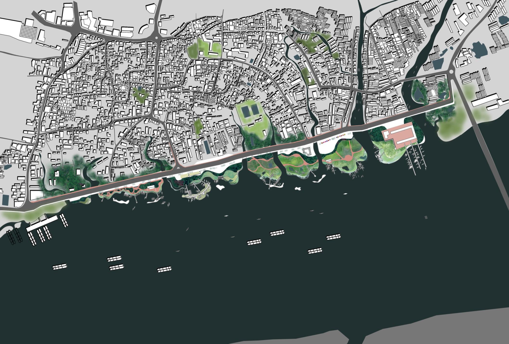
Fishery boat area
Res�ng place for fishermen
Cold storage & processing
Evic�on of illegal structuresbeside channels, and protect as valuable vegeta�on area.
Protec�ng exis�ng green spaces and connect them to achieve a green network along river and road.
Old fishery market and cold storage place turned into community park.
New loc�on of fishery market and fishery ghat, minimizing transport hassle and jam 0m 100m 200m 500 m
FISHERY GHAT1 2 3 4 1 2 3 4
8
Master Plan
B. Arch Fourth Year Design Studio
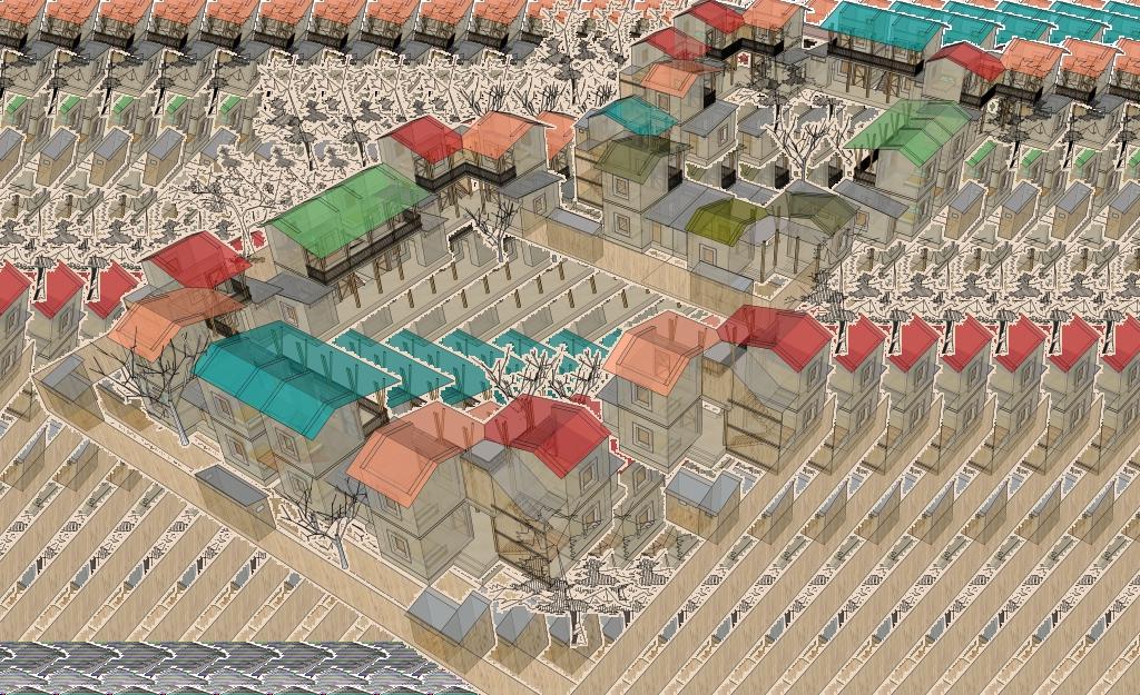
Visioning Sustainable Village STUDY AND DESIGN OF ETHNIC RURAL HUMAN SETTLEMENT
Site: Hobuarchala, Gosaibari.
Kaliakoir, Gazipur
Distance from main town: 8.12 km
Distance from reserved forest area: 0.6 km
Current Se�lement Pa�ern: Rural. Amorphous. Sca�ered. Profession: Agriculture, Livestock, Small business.
Sal Forest is a forest type dominated by a single plant species, commonly known as Sal tree (Shorea robusta). It belongs to the category 'Tropical Moist Deciduous Forest'. Just 100 years ago, this invaluable forest land occupied a lot more land area. Con�nuous unplanned deforesta�on for human need, as well as spread of sca�ered se�lement through the area has been detrimental to the forest ecology.
One of the main objec�ve of the project was to save the forest land, proposing acompact rural se�lement pa�ern which will coexist with the forest not crea�ng any harm to the trees and bio-diversity.
The another objec�ve was to inves�gate the common rural housing pa�ern of Bangladesh, and see how ideas of ‘Compact township’ can provide be�er opportuni�es and create a more sustainable future for a country which is suffering to accommodate its huge popula�on. Also, design decisions were made with precision to ensure the new design solu�ons do not compromise with the essence of rural life, but promotes opportuni�es for future development.
The village site we worked on was home to ethnic people, who had a close rela�onwith the forest. Notably, a range of tribal people(Garo and Koch) has been dwelling and they are dependent on Sal forests for their total livelihood.
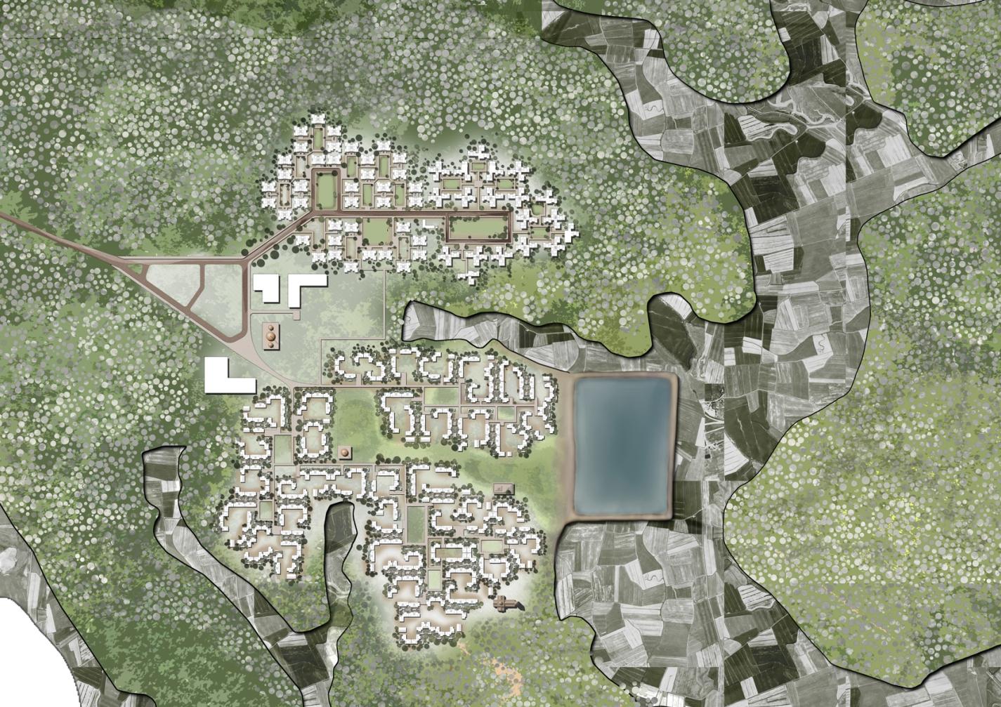
1 Rural road
2 Cluster Housing Unit with inner yard
3 Common playground/Community place
4 Central Pubic zone with -School & playground -Mosque -Community Club -Church
5 Shal forest
6 Baid -low land areas/ Agricultural land
masterplan 0 100’ 200’ 300’ 1 2 2 2 3 4 3 5 5 6
Sec�on through the courtyard of a community cluster of houses
9
The excessive amount of popula�on and its fast growth rate has already created serious problems in Bangladesh, including loss of agricultural land, less livable ci�es and deforesta�on. Compact township is a notable idea, from Economist Professor Salim Rashid. The idea is basically a futuris�c planned approach of rural se�lements, where a number of ‘se�lement units’ will be formed with all basic facili�es and housing. They will replace the exis�ng sca�ered rural homesteads, and preserve valuable cul�vable land and will be flood resilient. The design idea is highly inspired from the compact township theory, applying the concept in ethnic rural village to save the forest land around.
Expandable Housing Unit
Axonometric View of the small clusters of family houses
Phase 1 Phase 2 Phase 5 Phase 4 Phase 3
10
Professional Architectural Work (BUILT)
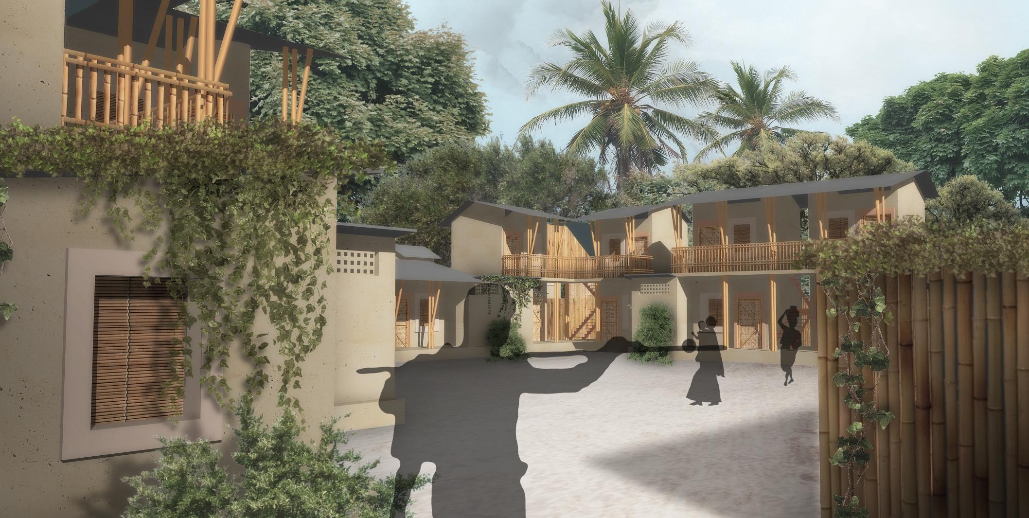
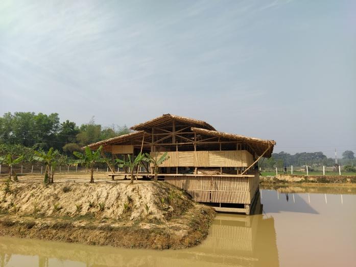
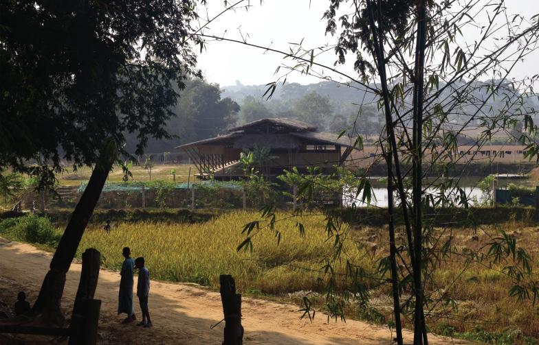
Bidyanondo Sampriti Orphanage School
EXPLORING VERNACULAR CRAFTSMANSHIP TO DESIGN AN ELEMENTARY CHILDREN SPACE
Loca�on: Baidyapara, Idgarh, Ramu, Cox Bazar
Client: Bidyanondo Founda�on
Site Area: 3300 sqm/ 0.81 acre
Year of Commencement: 2019
Year of Comple�on: 2020
Architect[s]: Kanak Saha , A.K.M. Saleh Ahmed Anik, Sayon Sur
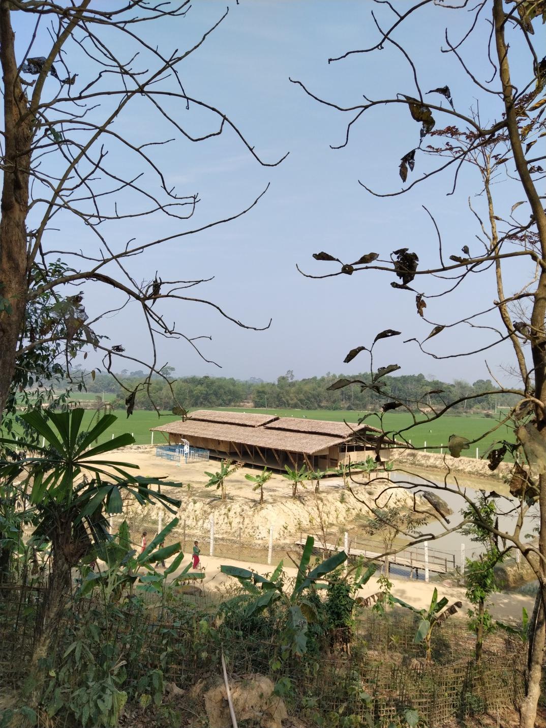
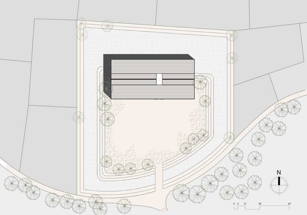
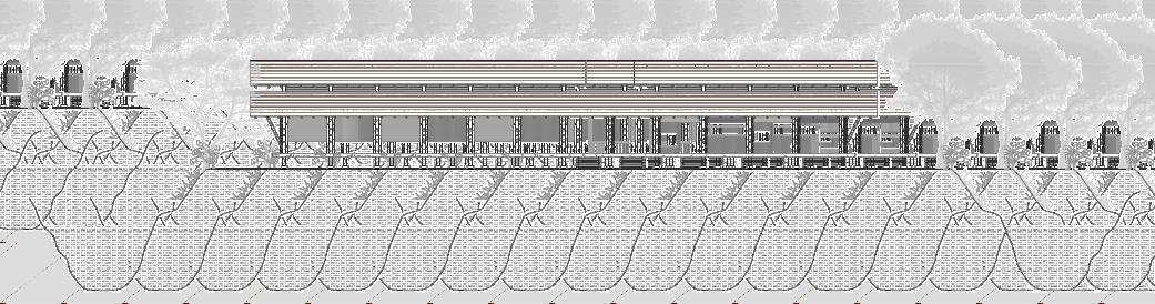
The school building is a bamboo-built structure on a raised �mber pla�orm, measuring roughly 28 m x 13 m. The pavilion-like school is placed carefully along the waterbody in a way that it can have enough space for assembly and playing space on the front yard, and also have a visual connec�on with the surrounding water and farmlands. The classrooms are arranged in a staggered manner to open up two semi-outdoor study/recrea�on areas on the front and back. The regional architecture of the southern part of Bangladesh and in the hill tracts are iden�cal in the use of a series of open, semi-open and interior closed spaces; par�cularly for the hot-humid clima�c features. The raised pla�orm is a major architectural element in hill tracts, which helps here to let flow the rainwater on the ground coming down from the hills and to protect the �mber.
11
Front Eleva�on
The ponds surrounding the built form are well protected and used for fish and water lily farming, adding to the sustainability and versa�lity of the school. The school here, not only imagined as a typical one, consists of classrooms and fields. But as a utopian idea where children learn not only from books, but also from the nature surrounding it and prac�cal knowledge like fishing or farming inside the school territory. Hence, openness and connec�on to the agricultural landscape was a key considera�on. The foyer has a metaphorical hearth at the center which is meant to grow a tree inside the built form, to celebrate the local spirit of living close to nature.
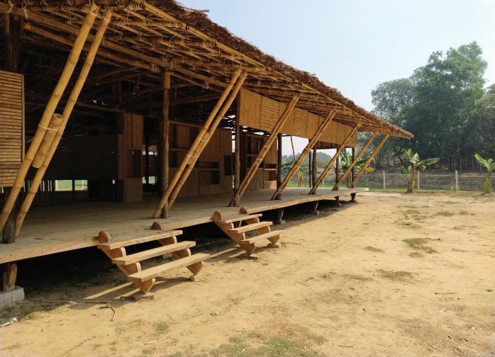
The basic materials-bamboo and wood were sourced locally. The roof was covered with Golpata (collected from the Sundarbans area), as we needed a roofing material that keeps the interior cool enough in the hot humid weather of Cox's bazar and is compara�vely low maintenance, also it creates a beau�ful combina�on with the other materials used. In the end, the local cra�smen did an excellent job and even improvised some of the solu�ons themselves. The elegant bamboo truss structure holds the built form, and the facade was also built of bamboo, where the facades were used to create shelves and recesses for mul�ple uses. The bamboo walls were designed in simple pa�erns and can be removed to create con�nuous open space inside to be used as a mul�purpose hall.
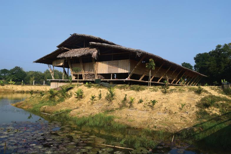
The landscape was more func�onal in a sense because the beau�ful ponds and the trees that were planted around the built form - were meant to add economic benefit as well as merge with the greenery of site surroundings. The plants were mostly fruits and vegetables which will be used to feed the children only. The fish farming and water lily pond also came with the idea of prac�cal learning of children and producing food for them. We planted some bigger tree plants on the periphery to create shade, most of them are s�ll growing.
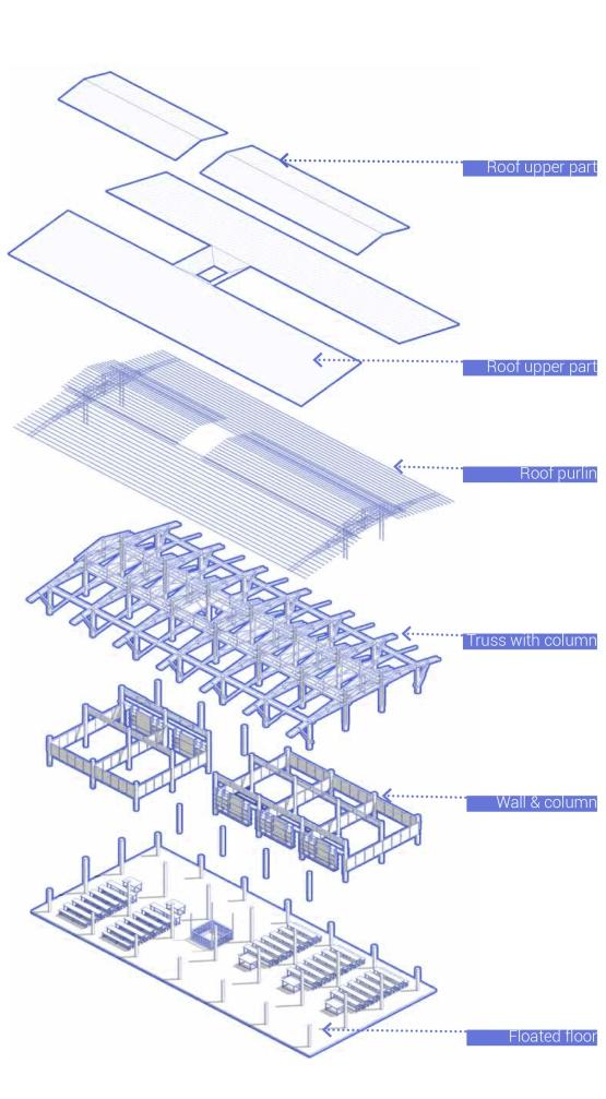
12 Exploded Axonometric View
Professional Architectural Work (COMPETITION ENTRY)
Golpahar Mohashawshan Temple Complex
SPIRITUAL LANDMARK X URBAN PLAZA
Awarded Special Mention
Na�onal Design Compe��on Arranged by IAB - 2021
Design Team : Kanak Kan� Saha, Jhalak Ranjan Das, Sayon Sur, Kwoshik Kumar
Site : Golpahar mor, Chi�agong.
Site Area : 0.33 Acres.
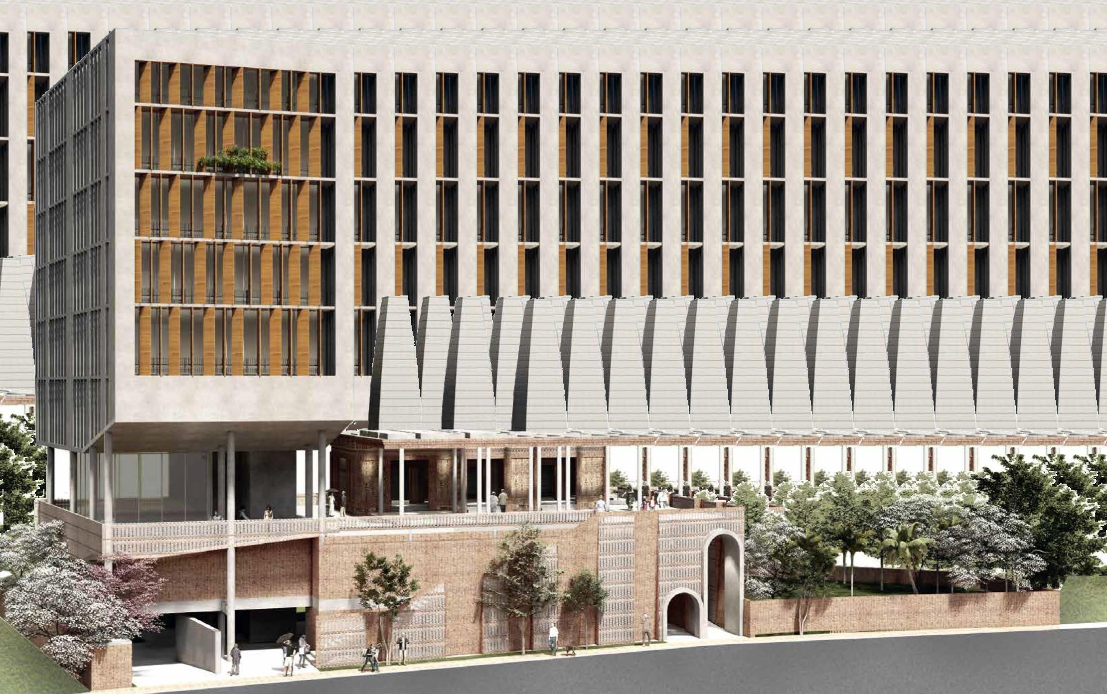
Golpahar Mohashawshan Temple has a deep rooted history and a special place in every Chi�agong ci�zen heart, the idea was to create a special religious landmark that revives the place not only as a religious complex but also as a place for ci�zens to gather and interact. To connect to people with their spiritual side, we arranged the temple plaza in respect with both Hindu & Bengal Culture. The temple plaza is designed in such a way that it not only encourages an individual to a�end a religious ritual but also helps to be engaged in a social interac�on. The open 2nd floor or the temple plaza is kept as an unobstructed open space, welcoming urban residents of the densely built city to enjoy a breathing space well above road level. Inspired from massive public plazas (like the Jama Mosque public plaza in Delhi) the idea is to let people come and connect to reduce the religious hatred and polariza�on. Also the plaza along with large mul�purpose hall, allows arranging fes�vals and gatherings. As one of the most prominent & old temple complexes of Cha�ogram, Golpahar Mohashawshan Temple has a duty to strengthen the bond among people of different culture. We believe, the more we explore our visions & ideas, be open to each other, the more we become helpful & understanding towards other people.
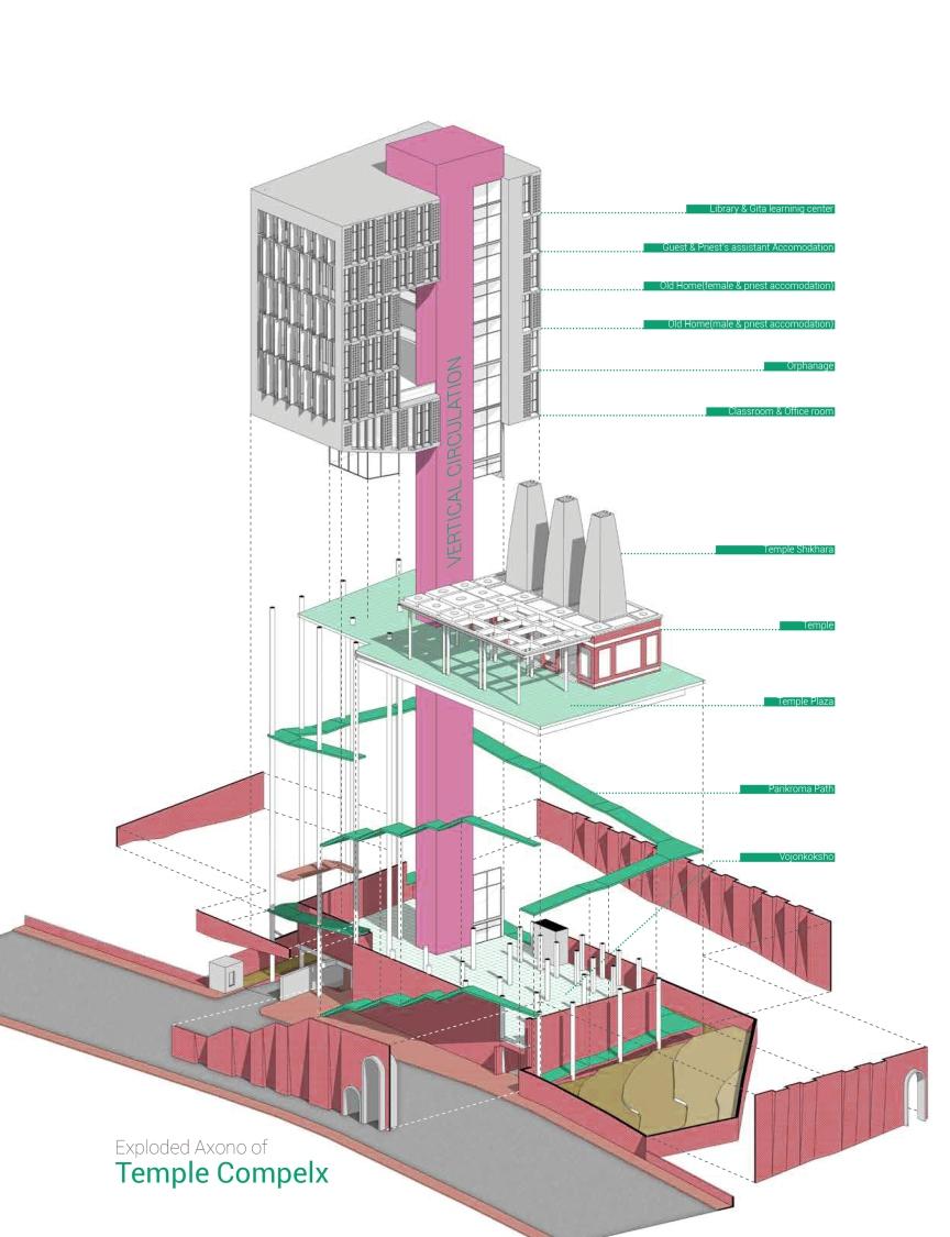
Exploded Axonometric View of Temple Complex
13
TRADITIONAL BENGAL TEMPLE:
Roo�yope: Dochala, Chouchala
Small Garbhagriha surrounded by open Pradakshina Path.
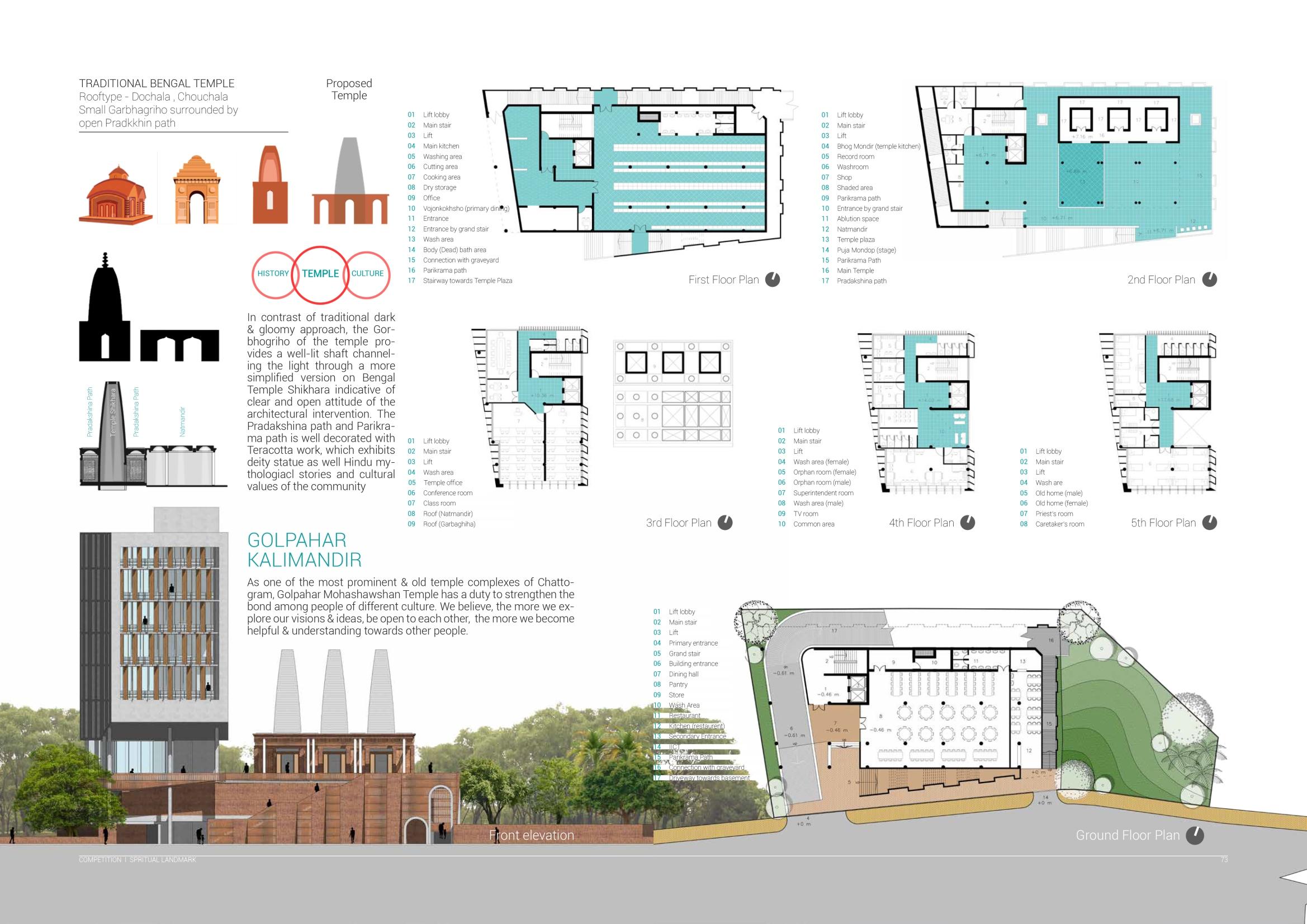
In contrast of tradi�onal dark & gloomy approach, the Gorbhogriho of the temple provides a well-lit sha� channeling the light through a more simplified version on Bengal Temple Shikhara indica�ve of clear and open a�tude of the architectural interven�on.
There are 3 different ways to the temple plaza. One is universal, more appropriate for the physically challenged people; going through building lobby & using the li�s. The second is more invi�ng way, the front open staircase decorated with brick jali. It dominates the roadside eleva�on to welcome people to seek & explore to the temple complex on the 2nd floor. The third is the most exci�ng one, resembling a Porikroma Path, a ramp corridor that goes around the temple complex. The journey will allow people to really devote themselves to a spiritual goal.
14
I +8801748137412