1 João Ferreira Curriculumvitae Portfolio
2 João Ferreira ArchitectandUrbanPlanner Contactinfo Porto,Portugal jgabrielmf@gmail.com +351938393321 portfolio: https://tinyurl.com/2kajm6jm EducationalBackground FacultyofArchitectureandUrbanismofUniversityofBrasília UnB2010-2016 MastersinSpatialPlanningandUrbanProject-FEUP-UniversityofPorto UP2020-2022 Achievements UndergraduateThesis ParkWay: UmBairroSustentávelParaaCidadedoFuturo •PublisehdinRevistaArqui#6 FAU-UNBPublication •HighlightedinIAB-DF(ArchitectsInstituteofBrazil) •Highlightedasoneofthe bestFAU-UNBstudentprojectsin1º/2016 •Honorablemention inthe28th OperaPrimaNationalContest2016 •Published inProjetoDesignMagazine#436,2016 •Exhibited inFAU-UNBGallery2016 re-RouteProject •Publishedin13th CITTAAnnualConferenceBook •Presented inthe13th CITTAAnnualConference2021-PlanningforHuman Scales MasterDissertation TheRoleofChildreninUrbanPlanning:Contributionsfromanexperimental ApproachinaSchoolinMatosinhos •Presented inthe14th CITTAAnnualConference2022-Safe,equitableand Justcommunities •PresentedintheInternatinalConferenceonChangingCitiesV2022Spatial,Design,Landscape,Heritage&Socio-economicDimensions. Softwares Languages English-advanced PortugueseBR-native Spanish-basic German-basic Archicad -Advanced Autocad2D -Advanced Sketchup/Layout -Advanced Vray -Advanced Lumion -Advanced AffinityPhoto -Advanced AffinityDesginer -Advanced AffinityPublisher -Advanced Photoshop -Proficient InDesgin -Proficient Illustrator -Proficient QGIS -Proficient Rhinoceros -Developing Desingbuilder -Developing portfolio:https://linktr.ee/jgabrielmf

UrbanDesignerandIllustrator-Drawingmapsandsiteanalysisandcreating3D illustrationsforsmallinterventions.
Internship - Responsiblefortheproductionofresidentialandcommercialarchitectural drawings;Conceptsin3Dand2D,draftsandtechnicaldrawings(interiorandexterior); elaborationofpresentationlayouts,measurementssurveys,andsitevisits.
Realizations BimColaborativo project: Coordinator ofMAAIArquiteturaIntegradaintheBimColaborativoProject-DF2019, promotedbySinduscom-DF.Thismultidisciplinaryeffortwasconceivedwithmultiple representativesoftheconstructionsectorincollaborationwithlocalauthorities.The objective,whichwastoacceleratetheimplementationofBIMtechnologiesinalllevels oftheconstructionsectorinDistritoFederal,wassuccessfullyachieved. Speaker ResponsibletorepresentMAAIArquiteturaIntegradainthefinalconference whichincludedanexpositionoftheyieldsoftheendeavor.
ProfessionalExperience MAAIArquiteturaIntegrada09/2013-06/2016
ProjetoViradaSustentávelBrasília2016-CidadeEstrutural: Volunteer- Responsibleforprovidingthenecessarytechnicalexpertiseandthe illustrationsneededinaco-designprojectfortherevitalizationofasmallalleyinthe disadvantagedneighborhoodof CidadeEstrutural inthecityofBrasília MAAIArquiteturaIntegrada04/2019-06/2020
MAAIArquiteturaIntegrada07/2016to04/2019
BIMManager - Responsibleforthecreationandimplementationofacustomized templateaswellasanewworkflowforthearchitecturalstaff,specificallycreatingnew librariesofobjectsandtextures(materialsandsurfaces),inadditiontothe reorganizationoftheoperationalstepsofarchitecturalprojectsandthestandardization ofprojectpresentation. Self-employedandFreelancer-07/2020-current Architect residentialprojectsinBIMonallstagesofproject.
Architect- Responsibleforthemanagementofarchitecturalprojects(residentialand commercial),inthesenseofleadingateamofinterns,handlingdeadlinesand customers'needs,moreoveractivelytakingpartcreativelyintheconceptionand elaborationofnewarchitecturalprojects.
3
DigitalArtist - Workingonmodelsandrenderingpicturesandvideosforarchitectural projects,urbaninterventionsandfestivals
4 Selectedworks
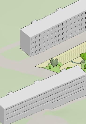
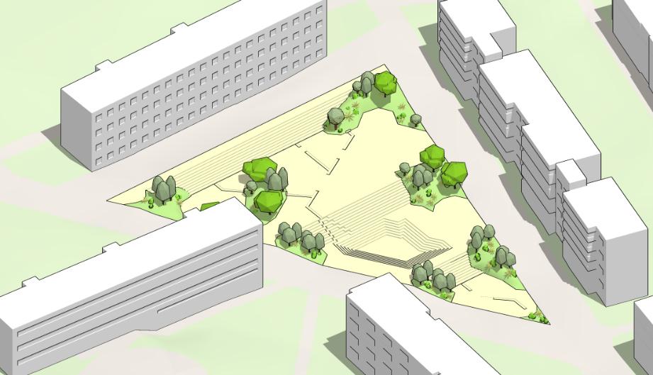
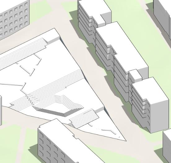
5 BrasíliaCineDrive-in RestorationandInterventionClass-FAU-UnBin Brasília,Brazil RainySeasonProgram UrbanStudioProject-StudyCase-MPPU-FEUPin Porto,Portugal re-Route/Masterdissertation Exploratorypractices RAParkWay Undergraduatethesis Largescaledevelopmentforaurbanneighborhoodin Brasília,Brazil 30 42 54 06
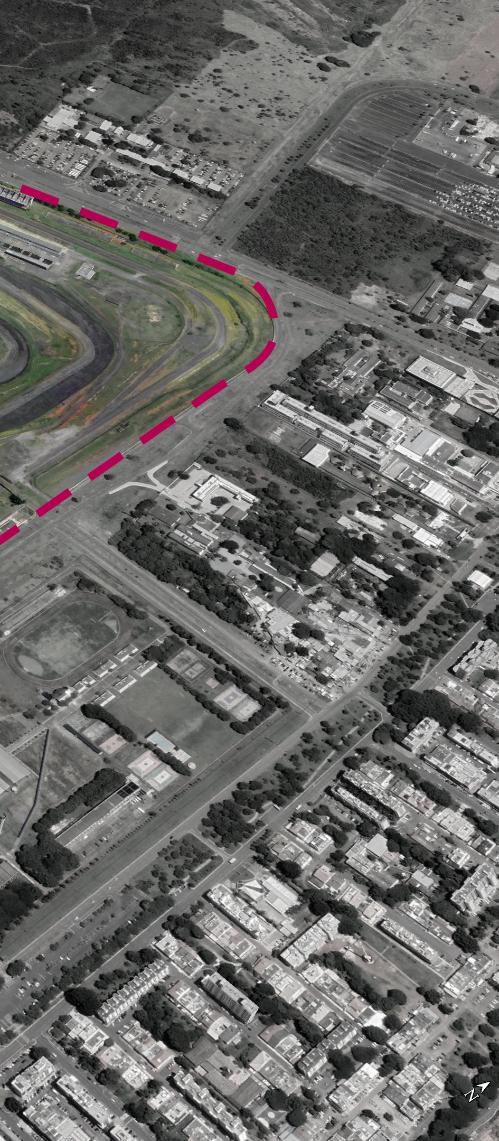
Undergraduatethesis-FAU-UnB Role:Student/Author- Urbandevelopment planforParkwayneighborhood Honorablemention inthe28th OperaPrima NationalContest2016 PublishedinProjetoDesignMagazine#4362016

Umbairrosustentávelparaacidadedofuturo
Introduction
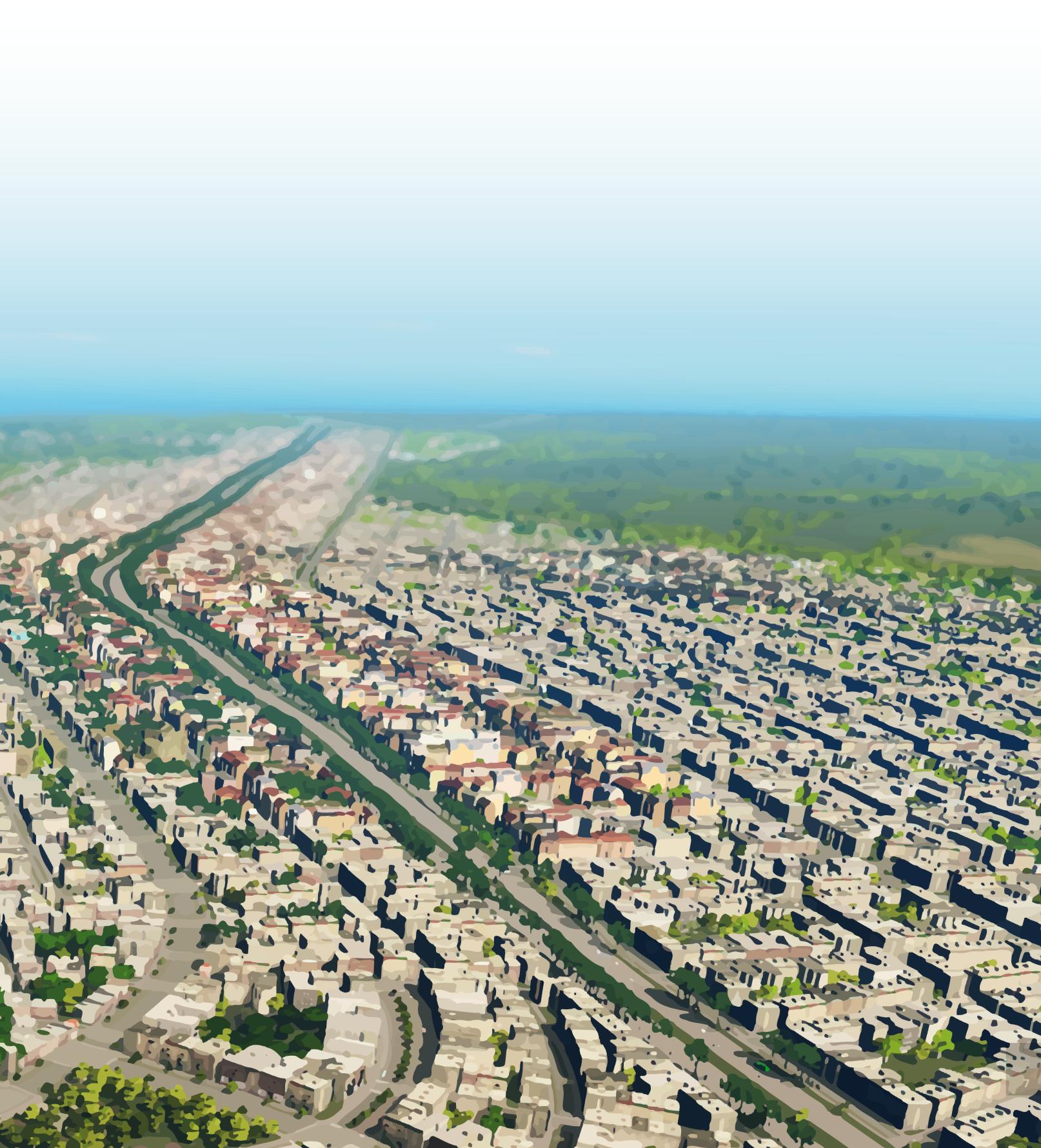
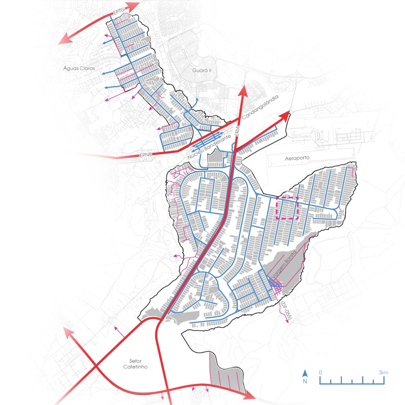
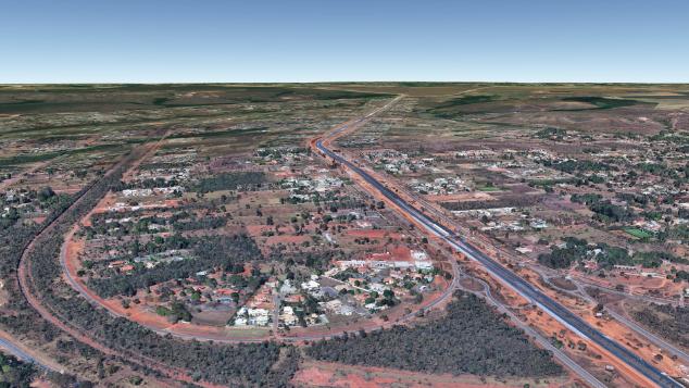
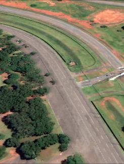
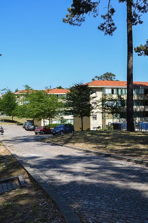
8 Location: Brasília-DF
TheParkWay standsoutamongitspeersforthehighrangeofissuesinits territory: Conflictswithenvironmentalzones,sprawl,irregular settlements,andsoilpollution,amongmanyothers.This neighborhood'schoicerevolvesaroundexploringthesymbolic aspectthatconstitutesatransformationofasprawled suburbancommunity,anexampleofthe20th-century urbanizationmodel,inacontemporaryurbansettingcapable ofholdingsomeofthevaluesthattheplanninganddesign disciplineshaveacquiredinrecentdecades.Undertheright conditions,theneighborhoodcanbeexploredtobecomean excellentexampleofsustainableurbanismforthecityof BrasiliaandBrazil.
ThisworkapproachesParkWay,oneofthemostextensive andoldestneighborhoodsofthecityofBrasília,fromthe perspectivethatoneofthechallengesofthe21stcenturyis theadaptationofourcitiestoasustainablesystemableto affordsocial,energetic,andenvironmentalresponsibilities.As theBrazilianfederalcapitalandahistoricalmodernistmark, Brasília-seekingtomaintainitsmostvitalessenceofbeing theexemplarymodeltotherestofthecountry-musthavea remarkablebastionintheBrazilianclimateadaptationeffort.
parkway


Themapillustratesthelevelofdegradationofriparian forestswithintheParkWayterritorycomparedtothe existingforestsinthesurroundingenvironmental reserves. Thegreenareasinsidethereserveshavemoremass andcontinuity,whiletheurbansectionspresent dwindlinganddispersesegments.
RiparianForests
Waterresources StreamsgenerallylimitthebordersofParkWay.The streamsofsection01(RibeirãodoGammasub-basin) areordinaryandlocatedinareasofanadvanced stageofurbanization.Thestreamsofsections02and 03(RiachoFundosub-basin)arepartiallyorentirely insertedinareasofecologicalreservesandare essentialforpreservingthewaterresourcesofthe cityofBrasilia.
ParkWayhasverygentlerelief.Atastraightline, tracedfromitshighestpointtowardthethelowest, theslopeisapproximately1.5%.
EnvironmentalReserves
9 SiteAnalysis
Theneighborhoodplacementintheregionisolates theeastconservationareasfromthewest environmentalreserves.Thissamebarriereffectis alsopreventingtheexchangeofbiologicalmaterial betweenBrasilia'sBotanicalGardenandBrasília's RoadSystem Theneighborhoodhasastreetsystemoflow connectivity,resemblingthestructureofatree.Trunks (primarypathways)distributethetraffictobranches (secondarypathways). Allroadshavesimilarcharacteristics,evenifthey meetdifferentfunctionsinthesystem:extensive laneswithtinysidewalksandbigyardsisolatingthe housesfromtheroadways.
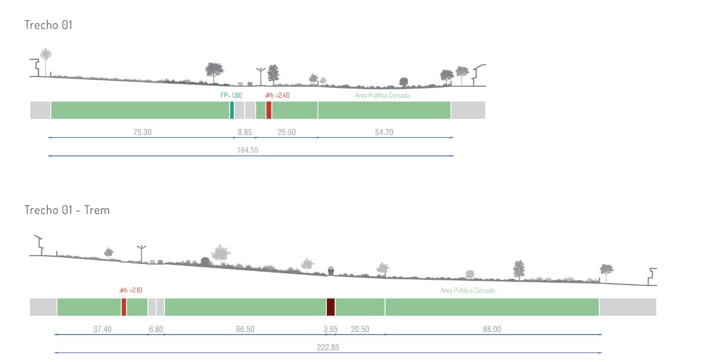
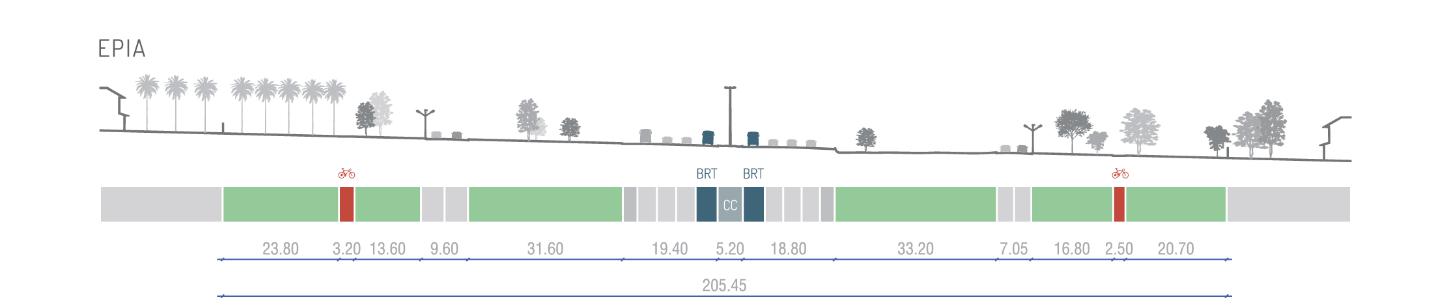
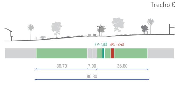
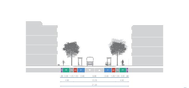
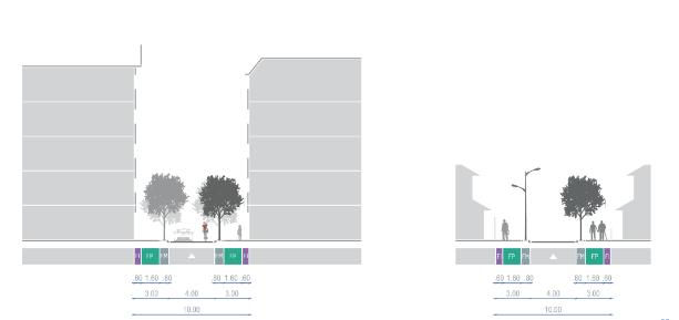
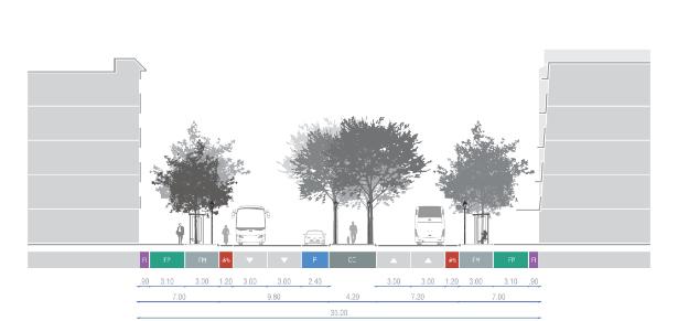
StreetCross-sectionsmap Thechoiceofroadcross-sectionsaimedat representinglocalcharacteristicsand,atthesame timedepictingthesubtledifferencesbetweenPark Waystreets. Inadditiontostandardstreets,twoothersections targeteduniqueplaces:theEPIAhighwayandthe roadsparalleltothetraintracks.Bothofthose symbolizemeaningfulelementsoftheneighborhood territory'sstructure.
Theregionswithroughestterrainarelocatednearthe watercourses.Themainformofoccupationinthese areasarechácaras(smallfarms)orillegalresidential plots.
NationalPark
Topography


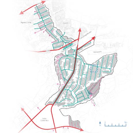
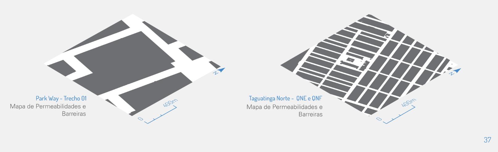
10 SiteAnalysis EPIA Trecho01 Trecho01-(traintracks) Trecho02 Trecho03

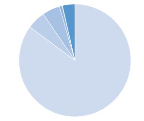
11 Over85%ofParkWay residentscurrentlyuse carsastheirmain transporttowork, school,shopping,and leisure Car85,1% Onfoot5,3% Bus5,1% Motorcycle0,8% Bike0,1% Others3,6% Only9,5%ofParkWay residentsworkinthe neighbohood PlanoPiloto62,2% ParkWay9,5% NúcleoBandeirante3,4% Others24,9% Only6,4%ofParkWay childrenstudyin schoolslocatedinthe neighbohood PlanoPiloto57% NúcleoBandeirante18,8% Taguatinga6,9% ParkWay6,4% Others10,9% Despitebeinglegallyurban,the densityoftheParkWayis comparabletothatofruralareas. Evenneighboringdistrictswiththe samesingle-familyresidential typologiesarecompletelydifferent intermsofthecomplexityofthe urbanfabric. 3streets 2connections 32streets 67connections


LandUse Despitenotallowingcommercialuse,ParkWayhasa fewscatteredstoresandservicesinitsterritory,often intheformofstallsortemporarystructuresina precarioussituation.Twoiconicexamplesarethe coconut-waterstand(01)onViaEPIAandthePark WayFreeMarket(02),locatednexttothebuildingof theofficeoftheassociationofParkWayresidents. TheParkWayFreeMarkerhappenstwiceaweek,and partoftheproductsofferedarelocallygrown. Landusewasmainlyorganizedaccordingtotheroad hierarchy.Theprimarystreetshavemorepotentialto developcommercialestablishments,somixed-useis permittedinthelandplotsadjacenttotheseroutes. Areasdestinedforinstitutionssuchasschoolsand hospitalsshouldbelocatedinmixed-useparcels.The onlyexceptionisthecampusareauniversitynextto FazendaÁguaLimpa,whichreceivedspecial permissionsandbuildingcodes. MapofProblems Inresume:ParkWay'smainproblemisthe homogeneouscharacteristicsofitslanduse.Beyond theproblemsderivingfromthistypeofsettlement, likewastedresourcesandbadharnessingofthe potentialofeacharea,thetypicalsuburbandesign encouragesbadhabits,suchastheexcessiveuseof carsandinformalsettlements.
12 SiteAnalysis
BuiltareacomparisonbetweenParkWayandanotherresidentialneighbohoodofBrasília
LandCover


ParkWay'sextensiveterritorydeliversa remarkablediversityofopportunities.Its territoryiscrossedbyarailroad,ametroline, andaBRTline,whichcouldbefully integratedintotheneighborhoodandevolve tonewcentralitiesgivenitslocationand elevatedaccessibility. Theregionpossessesmanysubdivisions withthepotentialfordifferentspecialties, dependingonitsclosestneighborsandits locationreferencedinBrasíliacitycenter.
Fencedvsacessibleareacomparison.Sameareasontheleft.
Diagnostic
13
MapofPotentialities

11.VargemBonitaRuralDistrict Specialization: Ruralactivities SpecialProjects: Eco-villagesandPermaculture
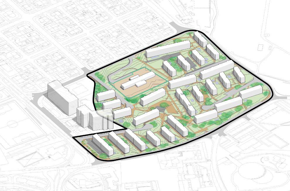
Project:SubdivisioninDistricts AmongtheproblemsobservedinParkWay,the generalizationofthelanduseandcoverofthe regionstandsout.Althoughtheneighbourhood possessesanincredible79km²,ithasfewtono offersofserviceswithinitsterritory.Theprimary landuseoftheregionishousingforBrasilia's middleclass.Thesubdivisionofthe neighbourhoodinminordistrictsaimsto carefullyconsidereachsectionofthesite followingitsparticularities,whether environmental,spatial,socialoreconomic. Theproposeddistrictsarecompletein themselvesandcapableofmeetingtheir residents'demands-forservices,businesses andinstitutions-proportionaltotheextentof theirterritories.However,theyshouldnotwork inisolationbutaspartsofoneunity.Eachdistrict shouldbeabletoarticulateorganicallyand dynamicallywithitsimmediateneighboursinside andoutofParkWay. TheuniqueconditionsofsomepartsofParkWay contributedtoestablishingfunctionsspecificto eachsite.Thisspecializationenablesthecreation ofspecificpublicpoliciesforeachregionthat couldpositivelyimpactthedistrict'sidentity. Theseelementsshouldaffectthepolitical engagementofthepopulation,thepermeating issuesoftheneighbourhood,andstrengthenthe community'stiesandrelationships. TheVargemBonitaRuralDistricthasan exceptionalcharacterbecauseitwillcontaina ruralcentrefortheregionandspacesdedicated toecovillagesandpermaculture.Thisproposal doesnotintendtointerveneinthespatial organizationoftheruralareasofParkway.Butit aspirestoreinforceexistingBrazilianlawsof wildlifeprotection.
3.FloricultureDistrict Specialization: Commercial Density: Medium,andlow LandUse: Mostlyresidentialwithnon-obligatory mixeduseinmainstreets.Exclusivecommercial buildingsareallowed. SpecialProjects: InterventioninBRTinterchanges
10.Mato-SecoDistrict Specialization: Eco-sportsactivities Density: medium LandUse: Mostlyresidentialwithnon-obligatory mixeduseinmainstreets.Specialpermissionsfor sport-clubsinstalations. SpecialProjects: BrasíliaCountryClubregeneration andintegrationwiththeurbanfabric.
SpecialProjects: WastewaterTreatmentPlant
5.IpêDistrict Specialization: Residential Density: High,medium,andlow LandUse: Mostlyresidentialwithnon-obligatory mixeduseinmainstreets. SpecialProjects: Shared-spaceinthelocalcenter 6.CentralDistrict Specialization: Localcommercial,servicesand offices Density: High LandUse: Mixed.Exclusivecommercialbuildings areallowed. SpecialProjects: GrandCentralStreet 7.RailroadDistrict Specialization: Residential Density: Medium,andlow LandUse: Mostlyresidentialwithnon-obligatory mixeduseinmainstreets.Exclusivecommercial buildingsareallowed. SpecialProjects: LinearPark 8.CedarDistrict Specialization: Suburbanresidential Density: low LandUse: Mostlyresidentialwithnon-obligatory mixeduseinmainstreetsandlocalcenters.
1.Metro-parkDistrict Specialization: Urbanparks,andlocalcommercial center Density: High,medium,andlow LandUse: Mostlyresidentialwithnon-obligatory mixeduseinmainstreets SpecialProjects: Newmetrostationonthelinethat alreadycrossestheregion.Restorationofthe BernadoSayãotrainstation.
14
9.VargemBonitaEco-TecDistrict Specialization: Tech-Cluster Density: Mixedwithspecialpermissionsfor campus,researchcentersandgovernment institutions. LandUse: Mostlyresidentialwithnon-obligatory mixeduseinmainstreetsandlocalcenters.
2.BernardoSayãoDistrict Specialization: Lowimpactindustry,andoffices park Density: Medium,low,andspecial LandUse: Mostlyresidentialwithnon-obligatory mixeduseinmainstreets.Officesandlight industry.
4.EpiaDistrict Specialization: Commercial,andregionalservices Density: High,andmedium LandUse: Mixed.Exclusivecommercialbuildings areallowed. SpecialProjects: Transformationofthehighway intoaurbanavenue.
1 2 3 4 5 7 8 9 10 11 6 15 Mostlyresidentialwithnon-obligatory mixeduseinmainstreets.Specialpermissionsfor BrasíliaCountryClubregeneration Eco-villagesandPermaculture Mixedwithspecialpermissionsfor campus,researchcentersandgovernment Mostlyresidentialwithnon-obligatory mixeduseinmainstreetsandlocalcenters. WastewaterTreatmentPlant

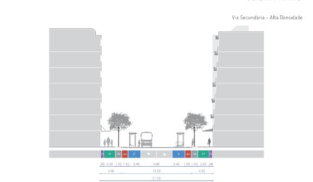
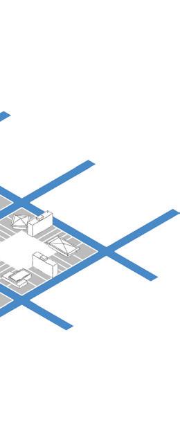
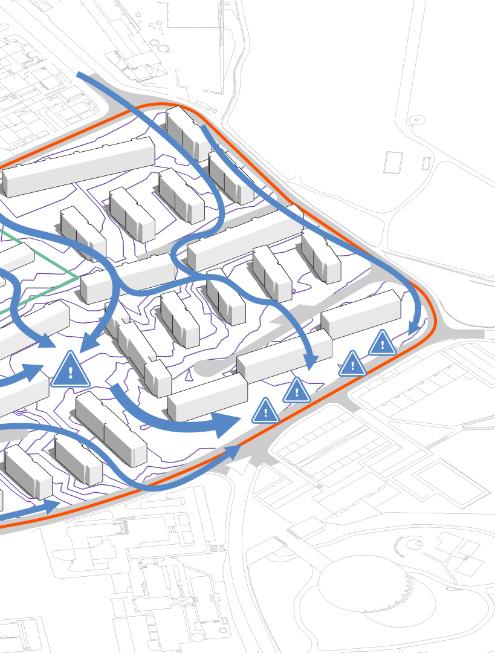
16 Project:StreetNetworkDevelopment Current -2016 Theneighborhoodhasastreetsystemoflow connectivity,resemblingthestructureofatree.Trunks (primarypathways)distributethetraffictobranches (secondarypathways). Allroadshavesimilarcharacteristics,evenifthey meetdifferentfunctionsinthesystem:extensive laneswithtinysidewalksandbigyardsisolatingthe housesfromtheroadways. Project -2060 Thenewnetworkdesignhasthreecentralpillars: Facilitatewalking through afabricadjustedtothe scaleofpedestrians.Adjustthenetworktoatransitfocusedstrategy.Andbindthenetworkinfrastructure capacitywiththeimportanceofthestreetandits degreeofcontinuity. Roadswithahigherdegreeofcontinuityand connectivitybecametheprimaryways,withbetter infrastructuretoaccommodatethemainbuslines. Followingthelatter,thesecondarypathsare responsibleforlocalbuslines,whilethetertiary routesareshortandonlyregardresidentsinthearea. 1 3


17 2 1 4 Junctionbetweena primarystreetwitha secondaryroad.


18 2 3 4 Junctionbetween EPIAstreetanda primaryroad Junctionbetweena secondarystreetand aterciaryroadina highdensitysector Junctionbetween twoprimaryroads (regularandsharedspace).


19 Junctionbetween twoprimaryroads (regularandshared-

20 MediumandLowDensity-PrimaryStreets MediumDensity-PrimaryStreet HighDensity-TertiaryStreet Project:StreetSections Existent: Trecho01(traintracks) Project:Trecho01(traintracks) Existent: EPIA Project: EPIA HighDensity-PrimaryStreet

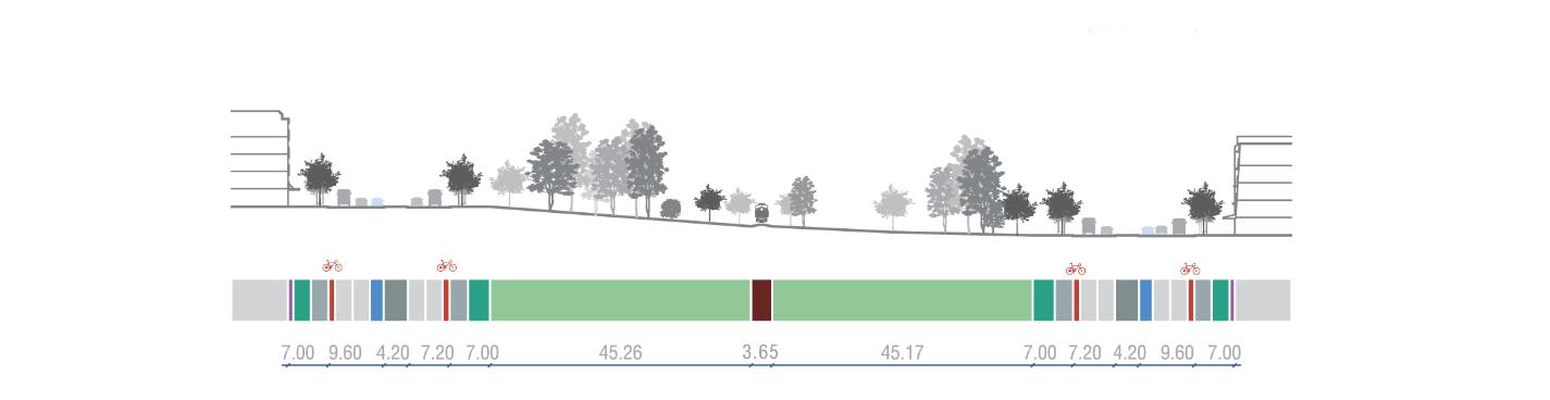


21 HighDensity-SecondaryStreet MediumandLowDensity-PrimaryStreetsLowDensity-SecondaryStreet MediumDensity-PrimaryStreet HighDensity-TertiaryStreet HighDensity-PrimaryStreet


22 Current -2016 Despitenotallowingcommercialuse,ParkWayhasafewscattered storesandservicesinitsterritory,oftenintheformofstallsor temporarystructuresinaprecarioussituation.Twoiconicexamples arethecoconut-waterstand(01)onViaEPIAandtheParkWayFree Market(02),locatednexttothebuildingoftheofficeofthe associationofParkWayresidents.TheParkWayFreeMarkerhappens twiceaweek,andpartoftheproductsofferedarelocallygrown. Project -2060 Landusewasmainlyorganizedaccordingtotheroadhierarchy.The primarystreetshavemorepotentialtodevelopcommercial establishments,somixed-useispermittedinthelandplotsadjacent totheseroutes.Areasdestinedforinstitutionssuchasschoolsand hospitalsshouldbelocatedinmixed-useparcels.Theonlyexception isthecampusareauniversitynexttoFazendaÁguaLimpa,which receivedspecialpermissionsandbuildingcodes. Project:LandUseDevelopment


23
Landusewasmainlyorganizedaccordingtotheroadhierarchy.The primarystreetshavemorepotentialtodevelopcommercial establishments,somixed-useispermittedinthelandplotsadjacent totheseroutes.Areasdestinedforinstitutionssuchasschoolsand hospitalsshouldbelocatedinmixed-useparcels.Theonlyexception isthecampusareauniversitynexttoFazendaÁguaLimpa,which receivedspecialpermissionsandbuildingcodes.


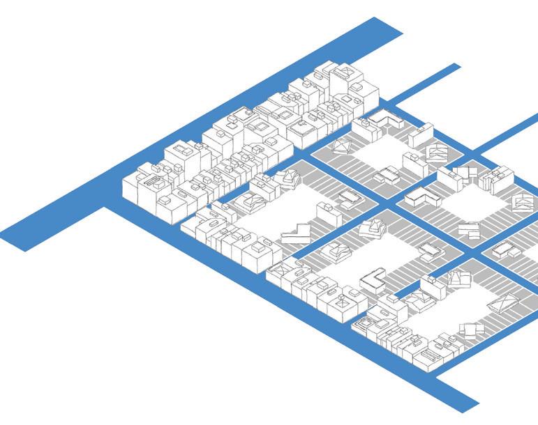
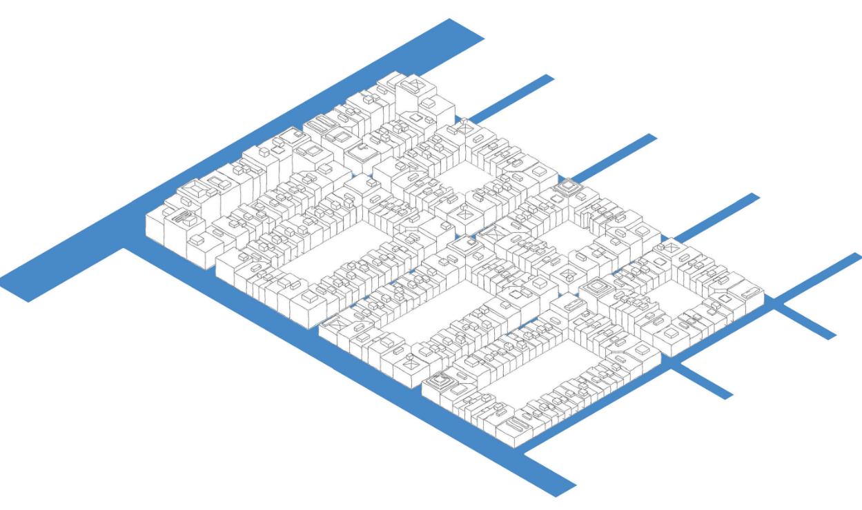
24 Project:LandUseDevelopment Current -2016 ThemapaboveshowshowsparsethebuildingsareinParkWay. Despitethesprawling,theedificationaredistributedhomogeneously throughouttheterritory.Thereisnodifferentiationinthebuilt structuresintheregion.Thetypeofhousingisthesame,nomatter thelocation.Theemptinessintheneighborhoodisaresultofthe originalprojectthataimedatemptypreservedstretchesofland. However,mostofthesespaces'originalfaunaandflorahavebeen replacedwithmanicuredlawns. Project Heightcontrol-2060 Controllingthebuilding'sheightwasoneoftheformsusedto managepopulationdensitythroughoutParkway'sdistricts.Central regionsareplannedtobethecenterofpopulationmass,witha gradualdecreaseindensityastheyapproachtheenvironmental reservessurroundingtheneighborhood.Anotherparametertothe building'sheightsistheproximitytoprimarystreetssincethosehave spacetosupportatransitsystems.


25 Heightcontrol-2060 Controllingthebuilding'sheightwasoneoftheformsusedto managepopulationdensitythroughoutParkway'sdistricts.Central regionsareplannedtobethecenterofpopulationmass,witha gradualdecreaseindensityastheyapproachtheenvironmental reservessurroundingtheneighborhood.Anotherparametertothe building'sheightsistheproximitytoprimarystreetssincethosehave spacetosupportatransitsystems.

26 1.Currentsituation 3.Newparcelsprojection Project:Developmentsteps 2.Newroadsprojection 4.Buildingemptyspace 5.Subdivisionofexistinglots 5.Consolidatethedevelopment


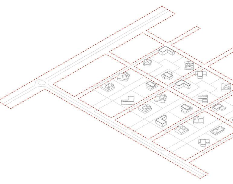


27 5.Developmentconcluded Project: Developmentsteps ThissmallscenariodemonstratesParkWay'stransformationprocess. Thegoalistoreachthemaximumpotentialdensityforeseeninthe projectinthedensestcentralregionoftheneighborhood:Buildingsup tosixfloors.TheexampleshowsasmallportionofParkWaywhereall parcelsreachedtheirmaximumpotentialforlandcoverfollowingthe currentrules. Thefinaldesignoftheroadsystemwillbeusedasareferenceforthe entiredevelopment.Theexistinggapbetweenthebuildingsandthe landparcelslimitswillbeusedtocreatethetertiarystreets(10meters total).Thiswillensurethatexistingbuildingscanco-existwiththe futureroaddesignoftheneighborhoodforawhile.Conflictsbetween thenewsystemroadandexistingconstructionswillbeminimizedby prioritizingemptyareas. Thenextstepisdefiningtheparcelsformedfromthesplitofexisting lotsandendorsingthenewbuildcodeforthearea.Current landownerswillparticipateindividingexistingpropertiesand influencingtheirpace.Afterthesplitting,sellingunits,renovations,and anyothertypesoftransformationsmustconformtothenewrulesfor landuseandoccupation.Uponcompletingtheroadsystemandthe infrastructure,theneighborhoodshouldbefreetodevelopatitspace. Before After


28 Metro-parkDistrict 1 BernardoSayão District 2 CentralDistrict 6 Epia District 4 5 IpêDistrict Project:Districtsfinalform


29 10 MatoSecoDistrict 9 VargemBonita Eco-TecDistrict 11 CentralDistrict RailroadDistrict 7 FloricultureDistrict 3 CedarDistrict 8


Role:Student/Author- Acessibilityplanand restaurationofaCineDrive-inbuiltinthe1970s.
ArchitectureandUrbanProject-Restauration andInterventionClass-FAU-UnB


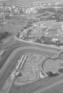
TheCineDrive-InofthecityofBrasíliaisamanifestationofitstime andplace.Thecinemawasbuiltin1973whenthemodernisttrendsof ametropolisengineeredforandsolelyforcarswerestillhighinBrazil. Despiteitsdeclineinthesubsequentdecades,partiallybecausethe conceptsofurbantransportationwererevised,thecinemapossesses historicalandmaterialvalue.In2017thecinemareceivetheprotection statusofCulturalHeritageofthecityofBrasília.
Themainobjectivesofthisrestorationprojectweretorevitalizethe materialstructuresofthecinema(theprojectionbuildingandthe screen),tocreateanewadministrationbuildingforthecomplex,to
Location:Brasília-DF
betterintegratethecinemawiththeurbanfabric,creatingnew possibilitiesofaccessfortheonesthatdon'twanttoarrivebycar,and tomakebetteruseofthespaceavailablesincetheareadestinedto thepublicwasneveroccupiedformorethanthehalfofitstotal capabilitiessincetheinauguration. Somepossibilitieswerediscussedwiththeownersandthelocal populationtodefinetheusesofthenewfacilities.Intheend, everyoneagreedthattheplacecoulduseanewgymnasiumsincea groupofindividualsalreadyusetheopenflatsurfaceofthedrive-into practicephysicalexercises.
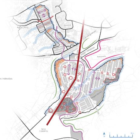
Introduction SRPNTrecho01Street SRPNTrecho01Street AerialView SRPNTrecho01andacessbridge
32 EixoMonumental SetorNoroeste AsaNorte LagoParanoá Autódromo SportComplex CineDrive-in


autódromo Closebusstops Commonpedestrianstreams Existentcyclepaths Proposedcyclepaths CineDrive-Inaccess Surroundsand MajorConnections CineDrive-in Estádio Nacional Ginásio NilsonNeslon ASANORTE SRPNTrecho01andacessbridge


34 Brasília’sSportComplex NationalStadium SportComplex IndoorArena Motorracingcircuit Kartcircuit CineDrive-in AquaticCenter Caraccess AccessBridge SportComplexboundaries Pedestrianpathproposal Legend


35 TheCurrentCineDrive-in


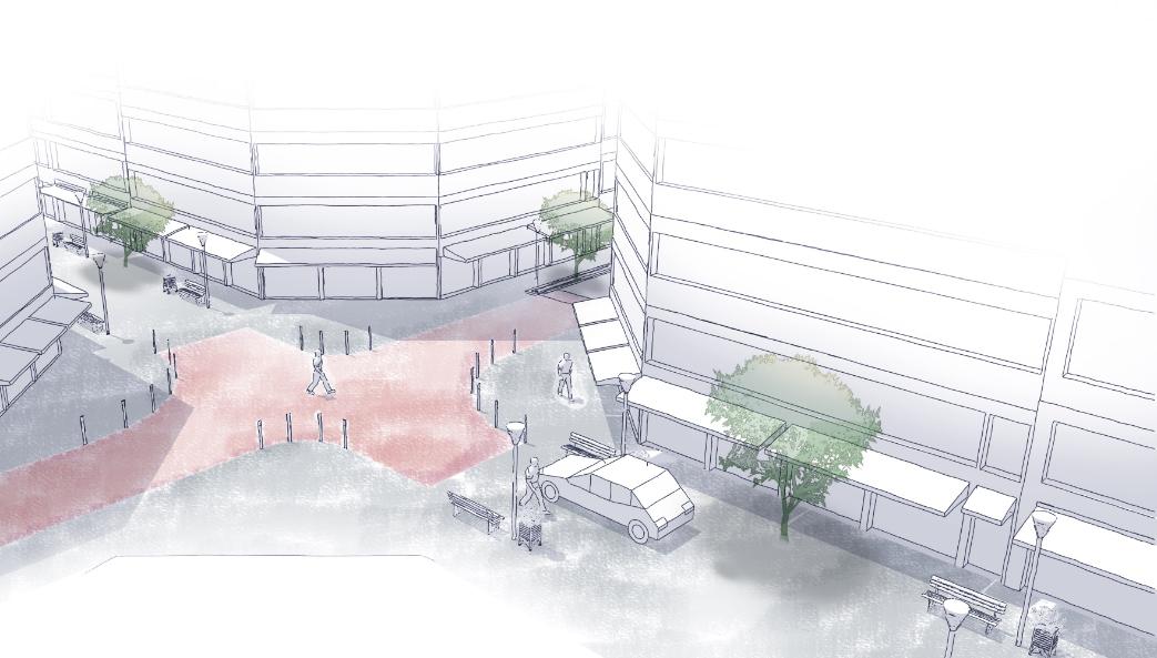
crossingthecomplex'sheart.Itstransformationintoashared spacewillcreateanewoptionforspecialusesduringsports eventsorotherfestivities.Theinterventionwillpromotearoad diet,removingonecarlanetomakeacyclelane.
Aninterventioninthecinema'ssurroundingsisnecessaryto improveitsaccessibility.Sincethedrive-inislocatedinBrasília's sportscomplex,thedesignmustbebeneficialforallthepublic equipmentintheregion(Footballstadium,AquaticCenter,Indoor Arena,Motoracetrack,etc).SRPNTrecho01isalargeroad
Concretewasimplementedinsmallstrechesfornewsidewalks, andinthecaseofeventsandsimilaroccasions,theutilizationof differentandnewtypesofurbanfurniturewouldberequired.
36 SRPNTrecho01Street SharedSpace
Theresultingspaceisversatileenoughtobeusedinmyriad waysdependingontheneedsofeachequipmentorevent,while atthesametimemarkstheentranceoftheCineDrive-In, offeringanewexperienceforthevisitors.
Sincetheproject'soriginalscopewastorehabilitatethecinema; theexternalinterventionsweremademainlyusingpaint.


Challenges: Keepthecostsofimplementationdown.Toreintegratethecinemawiththecityfabricimprovingitsaccessibilitiesconditions.
Spaces: PartoftheNationalStadium'sParkingLot;theSRPNTrecho01Streetanditsparkingspaces.
Concretewasimplementedinsmallstrechesfornewsidewalks,andinthecaseofeventsandsimilaroccasions,theutilizationofdifferent andnewtypesofurbanfurniturewouldberequired.
TheNewCineDrive-in NewPath Motorracecircuit
Materials: Sincetheproject'soriginalscopewastorehabilitatethecinema;theexternalinterventionsweremademainlyusingpaint.


38

Materials: Thestructureswererehabilitatedwiththeiroriginalmaterials.Thenewstructuresreceivednewmaterials inordertodifferentiatethemfromtheoriginalones.
Spaces: Thecinemaitself,withthescreen,theprojectionbuilding,andtheareaformoviegoers.Theadministration building,withthepublicbathrooms,andthegymnasiumbuilding.
39
Challenges: Toproportionateabettersensorialexperiencetothemoviegoers.Tomakebetteruseoftheareaofthe complex.


40


41


(
Role:Student/Co-Author(Groupof4) all elementsdisplayedinthis portifoliowereproducedbytheauthor) Programtoenhancethepublicspacestosupportthecommunityduring theseasonsofrainfocusingonaspectsofsocialandurbanresilience.
42
UrbanStudioProject-StudyCase MasterinSpatialPlanningandUrbanProject-FEUP
43 1.Therainyseasoncompromisesthecontinuityofdailylifeinexternalspaces,whichincreasesthelackofsocial contactandtheintegrationofcommunities. 2.Vulnerableneighborhoodsareparticularlyaffectedbythisproblemdueto: •Thedeficienthousingconditionsmakesthepopulationlookforalternativesinthepublicrealm. •Privatesolutionsarenotfeasibleforthesegroups. •Childrenandadultsrelyonthepublicspacesasaplaceofacquaintanceship. •Thelackofstructurestosecurecommunityencounters. •Theinefficiencyofinstrumentsofpublicparticipationneighborhoods. Manypublicspacesareincapableofsupport publiclifeduringtherain. IdentifiedIssue: Concept: Enhancethepublicspacestosupportthecommunity duringtheseasonofrainfocusingonaspectsof socialandurbanresilience. The mainobjective oftheRainySeasonprogramis: Thesecondaryobjectivesare: •ImplementhardmeasuresinaccordancewiththeprinciplesoftheNewUrbanAgenda(UN-Habitat,2020). •Designwithafocusonnature-basedsolutions,greeninfrastructure,climate-resilientdesign,andwater-management strategies.(GlobalCommunityAdaptation,2019) •Makeanactiveefforttoengagethetargetedpopulationinallstagesoftheprogramimprovingcitizenparticipation.
2.Theorganizationofaprogramofactivitieswithafocuson socialresilience
ImplementationofActivities ConDomuswillberesponsibleto managetheactivities.
1.Aninterventionintheinfrastructureoftheneighborhoodswithafocuson environmentalresilience
Toachieveitsobjectivestheprogramisorganizedaroundtwomainstrategies:
Implementationofinfrastructure: CâmaradoPortoandregional&urban developmentEUfundswilltake OrganizationofActivities: Thedevelopmentoftheiterativeseasonal itinerantstructureswillfollowabottom-up strategywithmultipleneighbohoods.
44
GeneralStrategies
ProgramImplementation
Choosingtheneighborhood: Theprogramwillfocusonvulnerableneighborhoodsand spaceswithinfrastructuredeficiencies.
Designofthebasicinfrastructure. Thedevelopmentofthecentralplaza,sidewalks,shelters, raingardens,lights,andurbanfurniturewillconformwith theprinciplesofEUadaptationstrategies.
Choosingthespace: Toestablishtheplazawillbenecessaryanopenspacewith thepotentialtoaggregateresidents(e.g.,anexistent square).

45 DesignElements MainPlaza Placeofencounterfortheresidentsandabasefortheproposediterativemodules. BasicInfrastructure Thisregardstoallfunctionsofthepublicspaces:drainagegardens,sidewalks,stairs, storm-waterfarming,urbanfurniture,busstops,clotheslines,etc… IterativeModules Modulesofactivitiescreatedthroughaiterativeprocesswithcitizensofmultiples vulnerablecommunities. 1.Pasteleira 2.Dr.NunoPinheiroTorres 3.BessaLeite 4.Aldoar 5.FontedaMoura 6.Campinas 7.Ramalde 8.Francos 9.Carvalhido 10.Regado 11.Carriçal 12.AgradoAmial 13.Outeiro 14.S.JoãodeDeus 15.PioXII 16.Contumil 17.EngenheiroMachado Vaz 18.S.RoquedaLameira 19.CercodoPorco 20.Falcão 21.MontedaBela 22.Lagarteiro LocationofpotentialvulnerableneighborhoodsinthecityofPortotoimplementtheprogram-source:authors

Thegeneralsupplyofcityamenitiesinits surroundingsmakesPasteleiraanidealtarget forourprogram.Sincethecommunityiswell servedbybasicfacilities,wecanfocusonthe improvementsthatourprogramhastooffer: theenhancementofthelocalinfrastructure andtheimprovementofthesociallifeduring winter. TheBairrodaPasteleira,builtbetween1958 and1960,wasoneofthefirstcollective housingcomplexesinthecityofPorto.It belongstothefirstphaseofthe“Planode MelhoramentosparaaCidadedoPorto” (ImprovementPlanfortheCityofPorto)and wastheneighborhoodwiththelargest numberofdwellingsatthedateofits construction.
ThePasteleiraneighborhoodfitsallthe criteriaestablishedbytheprogramtoreceive anurbanintervention.Despitebeinga vulnerablecommunity,PasteleiraiswellpositionedintheurbanfabricofPorto,which resultsinnumerousurbanamenities.The areahasanEscolaBásicawithinits boundaries.Itissurroundedbytwourban parksandonefootballfield.Besidesthat,the areaisservedbyasmallcommercialcenter andafewbuslines.
46 StudyCase:PasteleiraNeighborhood


47 SiteAnalysis Maps Clockwise:landuseandsurrounds;pedestrianpaths;bus routesandstops,parkingspacesandparkinglots;existing infrastructurededicatedtotransportandotherservices


GuideLinesforIntervention
Theneighborhood’sanalysisanditssurroundingsare importanttodeterminetheguidelinesfor implementingtheproject.IntheRainySeason’s program,itisimportanttoconsiderthepaththatthe rainwatertakesontheland.Pasteleira’sterrainisvery steep,whichcontributestothewaterrunningfast alongstreetsandsidewalks,makingitdifficultforthe greenareastoabsorbit.Withanalysis,itispossible todeterminethebestdesignforarainwaterdrainage system,anditisalsopossibletopredictplaces wherewaterretentionoccurs.Thesespacesare candidatesforreceivingraingardens,besidesthose proposedthroughoutstreetsandsidewalks. MainPaths
48 Newsidewalks Pasteleira School Sharedspaces Linesclothesspaces Newpathnetwork Pasteleira School existentpaths CurrentSituation Pasteleira School Waterpaths Retainzones Waterlines
Theprojectfocusonmakingthepublicspace attractivetopeoplewhenitisraining.So,itiscrucial tounderstandthemainpedestrianchoicespaths. Because,togetherwiththewaterlines,theywill determineprojectaspects,suchasthesidewalks design,theraingardenpositions,thebestplacefor themainplaza,andwheresecondaryrestingspaces withbenches.InPasteleira,themainpathsconnect theneighborhood’scentertothebusstopsand crosswalksaroundit. Newpathnetwork Togetherwiththesetwoanalyses,itispossibleto determinewhichisthebestnetworkpathforthe area,whichembracesthewaterlinesandthe previouspedestrian’schosenpaths.Theprojectalso maintainstheexistingsharedspacesthatarenearto thecenter,becauseitisanimportantstructureaxis. Inthisstudycase,theprojectproposesnewpaths
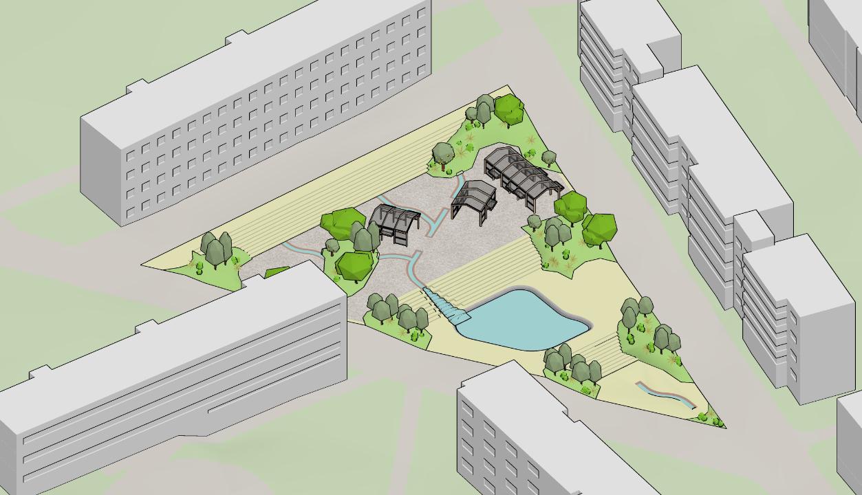
Withthenetworkpathestablished,itispossibleto allocatetheprincipalinfrastructureelements.The stairsandrampsmustbewell-positionedbecauseof theterrain’scharacteristics.Theymustbeaccessible andsafeforallresidents,especiallytheoneswith reducedmobility. InouranalysisfromthePasteleira,thebusstopsare inagoodnumberandlocation.Inothers neighborhoods,theycouldbere-positionedandnew onesmightbeneeded.Anyprojectshoulddesign themwithshelterstoprotecttheuserfromtherain. Theclotheslinesalsoreceiverainprotections,which willbedescribedinfurtherpages. Thecentralplazafunctionsasasurfacewaterstorage system,thatcontributestowardstheenvironmental qualityofurbanspace,aswellasstrengthening neighborhoodidentitiesandofferingagreeableleisure spacestothecitizens.Besidesitshydraulicfunction, thesquaregivesanewmeaningtothespaceand providesattractivefeaturesthatwouldappealto usersofthesurroundingbuildings.Thiskindof infrastructureisanexampleofthebenefitsthatcan accruewhenpublicfacilitiesareexplicitintheirutility, andwhentheyevenfreethespacefrombeing limitedtojustonefunction.Thankstotheirversatility andthevarietyofguisestheytakeonovertheyear,it bringsdynamismandinvitespeopletocomeand enjoyit.
thatpromotefacilitatedinnermobility,keepingthe connectionsbetweenthesurroundingsandthe neighborhood'scenter. Newelements
Waterlines


49 Pasteleira School Mainpaths Mainpaths Pasteleira Stairsorramps Raingarden Clotheslines Mainplaza School Busshelters Newelements


50 05 01 03 1.Thelimitsoftheplazapreviouslyestablishedbythegroup takesintoaccountthepositionoftheexistentbuildingsas wellpathsaroundthesquare.Thesitedrops5meters northtosouthwhichisachallengetodesignaccessible andcomfortablepacesforusers. 2.Toensurecomfortableandusablespacesweproposethe creationofplateausrelativetotheadjacentstreets. 3.Thedrainagesystemsareincorporatedinthedesignin ordertoraiseawarenessofthecitizensoftheimplications ofwaterinthecity.Besidesthedrainageroutes,small reservoirscanbehelpfultoreliefthesystemduring extremeevents. 4.Insomecasesthetopographycanbeadjustedtoform windbarriersensuringaadequatemicroclimateforthe populace.Itsimportanttoincorporatepassiveelementsin thedesignthathelpstoreliefconditionsimposedbythe localweather. 5.Intherainyseasonthelocaldrainagesystemisdirectedto theplazathatproceedstodrainthereceivedwaterina muchslowerrate.Thewatertankwouldbefullonlyin reallybigstorms. 6.Indryweathertheplazafunctionslikeanyotherplaza.The infrastructureisadaptedtobeusedduringsummer. 7.Withintheguidelinesmultipleapproachescanbetaken. Nature-BasedSolutions,forexample,arecost-effective, nature-inspiredstrategiesthatbringsocialandeconomic benefitsinadditiontohelpingtobuildamoreresilient society. 8.Thefinaldesignwouldbedefinedwithandbythelocal communityensuringthateachinterventionwouldfitthe needsofthelocalresidents. Newsidewalks MainPlaza School Sharedspaces Linesclothesspaces StudyCase MainPlaza


51 04 06 5m N 02


52 07 08


53 08 07


There-RouteprogramisaPersonalized TravelPlanninginitiativeaimedatthe temporaryresidentsoftheCityofPorto thatarealready,orwillingto,walkintheir commutes.Weencouragetheparticipants toexplorethecity,discoverbetterroutes totheirdailydestinations,acknowledge placesintheirneighborhoods,observe theconstructedenvironmentandreflect upontheactofwalkasadecisionrather thanalastresourceoption. Theprogram'smaingoalistoincentive theparticipantstoadoptwalkingasa genuinetravelmodethroughthe explorationofalternativetravelroutes.The initiativeiscomposedoftwostrategies withapersonalizedexperience.Thefirst oneisanaidprogramfortheparticipants tosearchforbetterordifferentwalking routesfortheirrespectivedestinies.Every participantreceivesoneormore alternativepathsaccordingtotheirneeds andavailability.Thesecondstrategyisto disseminateinformationregardingthe benefitsofwalking.Duringtheone-week durationoftheprogram,theparticipants willreceivedailypiecesofinformationina friendlyformat. Theexperimentwasconductedinthecity ofPorto,Portugal.Inthecity,thereisa broadcommunityoftemporaryresident students.Beinglocatedinacompactcity, theUniversityofPortopossesses campusesneareitherthehistoricalcenter ortosomeoftheresidential neighborhoodsofthecity.Thiscontext providesanopportunityformany internationalstudentstolivewithina walkabledistancefrommostoftheir classesandstillenjoyathrivingurban environment. There-Routeprojectisapullmeasurethat wouldserveasacomplementtoamore robustmobilityprogram.Thecityof Porto’spedestrianinfrastructurerequiresa reformulation.Allvolunteersinthe programshowedtheprecariousnessof theinfrastructureasabarriertowalking, andthiscompromisedtheirprogram experience.Someofthemajorchanges thatthecityneeds,accordingtothe opinionoftheparticipants,arethe improvementofintersectionsaimingat pedestriansafety;thereductionofthe speedofcarsincommercialareas;and theincreaseofthesidewalks’width.
54 re-RouteProgram

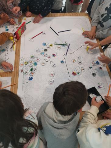
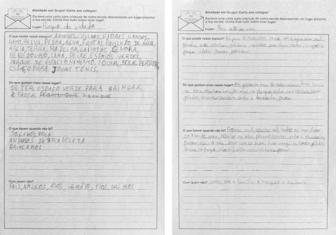
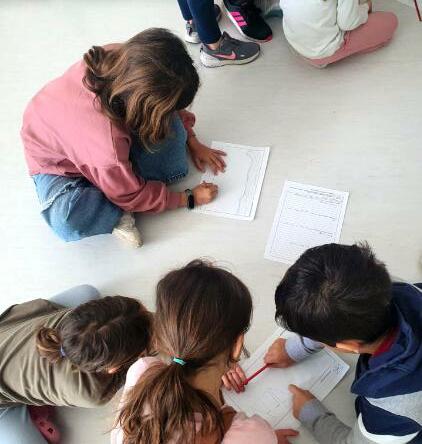
Theexploratoryexperimentpresentedin thisstudyaimedatinvestigatingchildren's responsestodifferentmediumsand approaches,multipleroles,andspatial scalesandevaluatinghowchildrencan contributetothepracticeofurban planninganddesign.Thefindingsindicate thatchildrencancontributetourban planninginnumerousways.Theycan produceandevaluatequalitative, quantitative,andspatialdatahelpfulfor improvingtheirandothers'environments. Childrenliketobeheardandparticipatein issuesrelatedtoactivities’methodologies. Theyarecapableofcontributingand discussingthesematters,offeringvaluable feedback.Theyareconcernedwiththe regulationsandproceedingsadoptedin theapproaches,theevaluationofdata, andthedecision-makingprocess.Ifasked, theywillhappilycommentontheactivities performed,indicatingmeritsandqualities, appointinglimitations,anddifficulties,and offeringsuggestionsforimprovingfuture endeavors.Childrenareinterestedinthe designofparticipatoryapproachesand havecontributionstooffer. Theyarecapableofworkingingroupsand achievingconsensusincomplex discussions.Theycanusedifferenttoolsin acomplementarymannertoexpresstheir needsandopinions.However,their contributionsshouldnotbeinterpreted withouttheirfeedback.Duetotheir nature,childrencanbeeasilymanipulated. Theytendtobelieveandagreewith adults'suggestions,especiallyiftheyhave apre-establishedrelationshipoftrust.The resultsoftheircontributionsfluctuate exerciseobjectives,andothers.Withouta constantandactiveeffortfromthe facilitatortoavoidshortcomings,children's participationcaneasilyleadtosituations ofmanipulationandtokenism.
H 11 P a 10 B ea h 9 P a a 3 N g hbo hoo d 3 S hopp g E a li h m e oo E a h m e C mm u P oo 1 10 P y 16 W a w h n m a s 5 F y 2 S w m W T V 2 S hop 2 P y w h sk a b k s oo e 2 A d m e a d sc p e 1 ee p 1 10 12 1 16 18 20 S en o y D sc m o 9 D K 8 a d equa o P a a d E x e e n e 5 B o n E p e e c D 3 P u on C w d d 10 12 1 16 18 20
accordingtotheapproaches,formsof communication,location,toolsemployed,
55
Masterdissertation: TheRoleofChildreninUrbanPlanning: ContributionsfromanexperimentalApproachinaSchoolinMatosinhos