
PORTFOLIO
JESSIE SUMMERS
ARCHITECTURELANDSCAPE
WORKS TABLE CONTENTSOF
SELECTED
integrating modern and historic design in paterson, nj planning play and education in englewood, nj
for students by students FLAT ROCK BROOK MASTER PLAN nature
revitalization of public open space in new york, ny
public performance space in woodland park, new jersey
GARRET MOUNTAIN RESERVATION
02 01 03 04 05 06
DUNDEE ISLAND resilient riverfront recreation in passaic, new jersey
RIFLE CAMP PARK AMPHITHEATER
RE-ENVISIONING CAMPUS master
HIGHBRIDGE
ANCHOR PARK
PARK
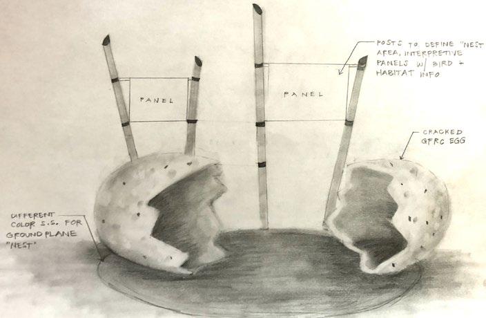
RIFLE CAMP AMPHITHEATERPARK 01
Rifle Camp Park is a 169-acre park within the historic Passaic County Park system. Located in the Borough of Woodland Park and adjacent to the expansive Garret Mountain Reservation, Rifle Camp Park is a beautifully forested park with varying topography that provides panoramic views of New York City and a forested respite for residents in a rapidly urbanizing area. The newly designed amphitheater is situated within an existing clearing in the park and replaces an outdated, underutilized existing block structure and lawn with a wood pavilion, decorative stone stage platform, and block stone seating to compliment the naturalized aesthetic of the park while increasing the programmatic function of the space. Taking advantage of the sloping topography of the lawn, the stone seating is thoughtfully arranged for multiple uses of varying attendees so that the space is utilized on a more frequent basis. The amphitheater will be home to various County events and summer concert series, as well as an outdoor classroom space for the John Crowley Nature Center and Observatory.
4
ROLE: DESIGNER (CONCEPT) / PROJECT MANAGER PASSAIC COUNTY rifle PARKcamp rifle PARKcamp CONCEPT DESIGN - VIEW TOWARDS SEATING


5 0 20'40' SCALE: 1" = 20'-0" DESIGN FEATURES 1 11109876543214 3 2 9 1110 5 6 7 8 AMPHITHEATER STRUCTURE ON DECORATIVE STONE STAGE STORAGE CLOSET + CHANGING ACCESSIBLESPACESTONE BLOCK SEATING STONE BLOCK GROVEPERFORMANCESEATINGLAWNFOROVERFLOW SEATING GRASS PAVER LOADING AREA (TWO 10 FT. X 20 FT. SPOTS) BOLLARD LIGHTING ALONG OVERHEADPATHWAY STRING LIGHTING A S PHA LT PAT HW AY BENCHES WITH COMPANION SEATING SCALE: 1”=20’-0” 0 20’ 40’ N

6 rifle PARKcampDESIGNFEATURES 1 4 32 9 10 5 6 7 8 20’ 0 10' 20' SCALE: 1" = 10'-0"rifle PARKcamp CONCEPT DESIGN - PROGRAMMATIC ELEMENTS OVERLOOK GROVEBENCH SEATINGPERFORMANCE LAWN SIGHT LINES MAIN SEATING AREADRESSING / STORAGE SMALL EVENT CAPACITY FIRST ROW AND BOULDER SEATING FOR OUTDOOR CLASSES APPROXIMATELY 100 SEAT CAPACITY HIGHEST VANTAGE POINT, EXTRA CAPACITY FOR OVERFLOW SEATING ACCESSIBLE TO PATH WITH COMPANION SEATING SLOPED LAWN FOR BLANKETS & CHAIRS APPROXIMATELY 300 PERSON CAPACITYPORTABLE CHANGING TENT FOR “DRESSING ROOM” AREA, ATTACHED STORAGE CLOSET SECTION PROGRAMMATICRENDERINGSECTION


7 rifle PARKcamp 0 20' 40' SCALE: 1" = 20'-0" OVERHEAD STRING LIGHTING GLULAM BEAM STRUCTURE ON CONCRETE STAGE STONE SEATING INTEGRATED INTO CANOPY TREES GRASS PAVER SERVICE ROAD OVERFLOW SEATING AREA ACCESSIBLE ASPHALT WALKWAY NEW PARK LIGHT POLE CONCEPT DESIGN PROCESS - ALTERNATE A


8 rifle PARKcamp 0 20' 40' SCALE: 1" = 20'-0" OVERHEAD STRING LIGHTING LOG STRUCTURE ON CONCRETE STAGE CONCERT LAWN GRASS PAVER SERVICE ROAD WITH PARKING AREA OVERFLOW SEATING AREA RELOCATE EXISTING BENCHES ACCESSIBLE ASPHALT WALKWAY STONE BENCHES WITH COMPANION SEATING


9 rifle PARKcamp 0 20' 40' SCALE: 1" = 20'-0" ARC STONE SEATING WITH UPPER CONCERT LAWN PREFABRICATED LEAF STRUCTURE & WOOD ELEMENTS GRASS PAVER SERVICE ROAD WITH PARKING AREA OVERFLOW GRASS SEATING ACCESSIBLE ASPHALT WALKWAY BOLLARD LIGHTING ALONG WALKWAY


ROLE: DESIGNER / PROJECT MANAGER MKW + ASSOCIATES, LLC RENDERING - ELEVATED FIELD HOUSE AND PLAYGROUND HARING RENDERING3D - AMPHITHEATER / NORTH END VIEW HARING 3D DUNDEE ISLAND PARK RECEIVED THE 2022 NJASLA HONOR AWARD, THE 2022 NEW JERSEY FUTURE SMART GROWTH AWARD, AND THE 2021 APA AWARD.


02
DUNDEE PARKISLAND
Dundee Island Park redesigns a neglected 6.73 acre park located in Passaic, New Jersey. Situated on a narrow strip of land partially within the active floodway of the Passaic River and adjacent to an abandoned railroad right-of-way, the park presents a unique set of regulatory, access, and flooding constraints. The new design includes an elevated field house, playground, splash pad, soccer field, fitness zone, amphitheater, and river walk arranged around a new vehicular loop. Native wet meadow plantings, rain gardens, and other green infrastructure methods are interwoven throughout the park in strategic locations and elevations to maximize floodplain storage and resiliency during storm events. The design not only adheres to NJDEP requirements, but also reflects the strong desires heard from the community for safety and accessibility, river access and resiliency, and multi-aged family focus. The project is the first phase of a multiphase movement to restore contiguous access to the river.
10
11 RENDERING - BIRD’S EYE VIEW HARING 3D


PHOTO CREDIT: EDWIN GANO PHOTO CREDIT: SEE PASSAIC COUNTY


PHOTO CREDIT: EDWIN GANO
12
13 COMMUNITY SCOPING COMMUNITYPROCESS FEEDBACK ANALYSIS RIVER COMMUNITY+RESILIENCYACCESS+FAMILYFOCUSEDSAFETY ACCESSIBILITY+ PARKING PLANTINGANDGREENSPACE LIGHTING ICESKATING ACCESSFROMMONROESTREET SOCCERFIELD NEW PARK ENTRANCES PICNICAREAS OBSTACLE COURSE COMMUNITYGARDENINGNATURE,HISTORIC, + STEM EDUCATION RAFTING,KAYAKING,+BOATING ADA INCLUSIVEPLAYGROUNDDESIGNENHANCEMENTS FLOODMANAGEMENT GRILLS/BBQAREA SECURITYCAMERAS GARBAGEANDRECYCLINGCANS GREENINFRASTRUCTURE TRACK AMPHITHEATER WITH RIVER VIEWSVISUAL CONNECTIONS FROM PULASKI PARK RIVERWALKACCESSTOPARKFROMACROSSTHERIVER/TROLLEYCONNECTIONSOVERRAILROADR.O.W.GAZEBO/SEATINGMOVIESINTHEPARKCONCERT/PERFORMANCEAREAVOLLEYBALL/TENNIS/BASKETBALLSIGNAGE DRINKINGFOUNTAINS/SNACKAMENITIES/CHARGINGSTATIONSFARMER’SMARKET DOCKANDBOATRAMP GAMETABLES


MOUNTAINGARRET RESERVATION
03
The Garret Mountain Reservation Phase II site is located within the 568-acre park located in Woodland Park and Paterson, NJ. The park was originally conceived by the Brothers firm as part of the Passaic County Open Space system, and the overall design balances current community needs while still maintaining important elements of the historic Olmsted Brothers layout. The project limits are broken into two main areas: the Auto Overlook and the High Meadow. The Auto Overlook improvements focus on increased accessibility, parking layout efficiency, and drainage improvements and enhancements. A new accessible route connects the Auto Overlook to the High Meadow, where a naturethemed playground sits atop the grade, punctuated with boulders, mounds, and planting. Other features include a shade structure, fitness area, and picnic grove. Both the High Meadow and Auto Overlook areas will include native plants exclusively which are suitable for Garret Mountain’s rocky soils and serve as habitat for migratory bird species.


14
ROLE: DESIGNER / PROJECT MANAGER MKW + ASSOCIATES, LLC 15’ 30’ N R H LINEMATCH LINEMATCH 25’ 50’ INITIAL CONCEPT DESIGN SKETCHES

15 0 15’ 30’ O H LINEMATCH LINEMATCH 25’ 50’ PLAYGROUND CONCEPT SKETCH PLAYGROUND DESIGN COORDINATION WITH MANUFACTURER


16 429 431 432 433 434 436 437 438 439 441 442 443 444 446 447 448449 451 452 453 446 447 448 449 441442443444 433 434 436 437 438 439 441 442443 444 446 447 448 449 452 448 449 451452 453 458457 456 456 457 458 459 458 457 456 454 453 452 451 449 447 448 449 452 453 454 456 457 458 459 458459 461 462 461 462 463 464 466 467 468 469 458 430 435 440 445 450 450 445 435 440 445 450 450 455 440 445 450 455 460 455 455 460 455 450 450 455 460 465 470 460 0 40' Scale: 1" = 40'-0" 20' 0 LINEMATCHSlope below 5% does not require landings and handrails Benches are accessible and provide higher views than existing Extend walkway to improve pedestrian access and circulation Create smooth surface for improved accessibility and Collectdrainagesurface runoff from parking lot, control erosion, and benefit 30pollinatorsParking spaces total ACCESSIBLE WALKWAY SEATING WALKWAY REPAVE WALKWAY RAIN REVISEDGARDENPARKING LAYOUT SCHEMATIC DESIGN PLAN


17 461 462 463 464 463 464 466 467 468 469 471 472 473 474 476 477 478 479 481 482 483 484 471 472 473 474 476 477 478 479 481 482 483484 466466 467 468 469 472471 473 474 476 477 479478 483482481 484 467 468 469 471 472464 466 467 468 469 471472 474 460 465 465 470 475 480 470 475 480 470 475 480 470 465 470 0 40' Scale: 1" = 40'-0" 20' 0 LINEMATCH Gateway experience with interpretive signage Not in contract Informal seating allows for performance opportunities, maximizes desirable views, and acknowledges site history Planting design prioritizes pollinators, native birds, deer resistance, fall color, and winter interest Accessible walkway with boulders and plantings to reveal site geologic value and history ENTRY PLAZA FUTURE COMFORT STATION GRANITE BLOCK SEATING PLANTING FITNESS AREA PICNIC AREA PLAY AGESAREA2-5 PLAY AREA AGES 5-12 QUARRY WALK SHADE STRUCTURE BIRD BLIND

RECEIVED THE 2020 NYASLA
RENDERING - ADVENTURE PLAYGROUND HARING 3D ADVENTURE PLAYGROUND (PHASE II) RECEIVED HONOR AWARD. PARK MASTER PLAN HONOR AWARD MASTER PLAN

AND THE 2020 NJASLA HONOR AWARD IN THE LANDSCAPE ARCHITECTURAL
As part of the Anchor Parks program, NYC Parks is investing $30 million “to bring new life” to Highbridge Park. It was selected for this major investment based on its potential for development, the needs of the large nearby user population and historical underinvestment. The intent of the master planning process was to document and develop a comprehensive plan for the development of Highbridge Park that addresses the needs of the local community and fulfills the aspirations for this iconic site to play a key role in New York City’s public open space system. Two capital projects were selected from the overall master plan and are currently under construction; Phase 1 reinstates access to a 10-block stretch of the park and includes pathway improvements and seating, new community gathering spaces, and a restoration of the historic Grand Staircase at Laurel Hill Terrace. The Phase 2 project scope includes the reconstructed Adventure Playground, a new comfort station, a new fitness area in the Sunken Playground and a new synthetic turf practice field north of the Highbridge Recreation Center.
04
THE HIGHBRIDGE ANCHOR
THE 2022 NJASLA
CATEGORY.
18 ROLE: PHASE 2 PROJECT MANAGER / ASSISTANT PLANNER FOR THE HBP MASTER PLAN MKW + ASSOCIATES, LLC
HIGHBRIDGE PARKANCHOR
ST. NICHOLAS AVEW160THSTREET STREET165THW BROADWAY STREET170THW STREET180THW STREET185THW STREET190THW SCOMFORTTATON PLAYGROUND WATER P AY DOG RUN BASKETBALL BASEBALL VOLLEYBALL HANDBAL POOL BMX COURSE SKATE PARK MOUNTA N B KE TRA LS H K NG TRA LS WA K NG PATHS CULTURAHSORC SPACESGATHERINGAL NTEREST NEIGHBORHOODRECREATIONAREAS 1 SOUTH END RECREATION FEATURE SUBAREA AMENITIES 12 11 10 9 8 7 654 32SUBAREA1 KEY MAP EXISTING PARK AMENITIES INVENTORY MASTER PLAN SCALE


Increase and upgrade spaces for outdoor gatherings and events
20 Five overall goals were identified to guide the development of the Highbridge Park Master Plan with recommendations for its implementation. To achieve these goals, a series of design objectives were identified.
Improve safety and individuals’ perception of personal security Improve connectivity within Highbridge Park Restore + preserve health and beauty of natural systems/ features and wildlife
To achieve these goals, a series of design objectives has been identified. As indicated in the matrix below, each objective addresses a primary goal yet may support various other goals.
Improve signage and physical connections to regional destinations and attractions
Address ADA issues and maximize universal accessibility throughout the park
Address issues of inadequate vehicular access for maintenance, security, and emergency staff
RECREATION PERCEPTION SECURITY CIRCULATION ECOLOGY
possible=PRIMARY
Restore views and vistas to the north and east through selective clearing of invasive vegetation
Goals and
Respect historic design intent and restore historic structures where
Implement sustainable design features
Create a connected, robust, park-wide system of paths and trails for pedestrians and bicyclists
Five (5) GOALS have been identified to guide the development of the Highbridge Park Master Plan and recommendations for its implementation:
Restore and protect forest habitat, unique features, and wildlife populations
Coordinate park-wide navigation signage
GOAL = SECONDARY GOAL
Upgrade quality of play Increase awareness and visibility of the Park’s resources
Improve east-west connections to the Park’s interior (restore and add stairways, create new trails)
HIGHBRIDGE PARK | 2018 MASTER PLAN 9
RECREATION PERCEPTION SECURITY CIRCULATION ECOLOGY OBJECTIVE
Enhance park entrances and gateway areas
Increase quantity and variety of playing fields
Increase quantity and convenience of public restrooms
INTRODUCTIONObjectives
Increase variety of recreational experiences
Incorporate green infrastructure
Improve lighting throughout the Park Open up views into the park from sidewalks
Open up views between spaces within the Park
Control (or eradicate) invasive plant species in active recreation areas
GOALS + OBJECTIVES MATRIX: Five overall goals were identified to guide the development of the Highbridge Park Master Plan with recommendations for implementation. To achieve these goals, a series of design objectives were identified.
Increase the recreation value of Highbridge Park Increase attraction and accessibility
Create an uninterrupted route for maintenance, operations, and security vehicles
21 New adventure-recreation features will be introduced and existing ones will be improved. City residents will be encouraged to try new sports, hone skills, and find fresh perspectives. Connectivity will be prioiritized with new entrances, path improvements, and maximum universal accessibility wherever feasible. A proactive management plan of its natural resources will be introduced as well as a visual park-wide design guide which will be informative and persuasive rather than regulatory. 59 Master Plan Map (continued) 58 STREET155TH STREET158TH STREET173RD HARLEMRIVERDRIVEWAY STREET164TH AMSTERDAM AVENUE EDGECOMBE AVENUE HARLEM RIVER DRIVE HARLEM RIVER 1.4 HIKING TRAILS 1.5 FITNESSFOREST 1.6 EQUIPMENTSEASONALRENTALS 5.5 SUGAR LUMINARIESHILLLAWN 2.1 MULTI-USENORTH-SOUTH/CONTINUOUSPATH 5.2 SUNKEN PLAYGROUND FITNESS 5.6 PATHSTRUCTUREDSEGMENTS 5.6 PATHSTRUCTUREDSEGMENTS 5.7 WATER TOWER TERRACE 5.3 PLAYGROUNDADVENTURE 5.4 FIELDPRACTICE Master PlanMASTERMap PLAN RECOMMENDATIONSMASTER PLAN RECOMMENDATIONS PLAN PHASE 2 - ADVENTURE PLAYGROUND PHOTO CREDIT: LANDSCAPE STRUCTURES


LOW POINT
22 FLAT ROCK BROOK | MASTER PLAN LEGEND WIND, SUN, + VIEW ANALYSIS
JONESROAD
FEMA SPECIAL FLOOD HAZARD AREA (SFHA) ZONE A EXISTINGLOWDIRECTIONFLATEXISTINGFLOODPLAIN)**(100-YEARSTRUCTURESROCKBROOKOFRUNOFFPOINTCONTOUR***
**SOURCE: FEMA NATIONAL FLOOD HAZARD LAYER (NFHL) DATASET. THE 1% ANNUAL FLOOD (100-YEAR FLOOD), ALSO KNOWN AS THE BASE FLOOD, IS THE FLOOD THAT HAS A 1% CHANCE OF BEING EQUALED OR EXCEEDED IN ANY GIVEN YEAR. THE SFHA IS THE AREA SUBJECT TO THIS FLOOD.
MER SUNPATH PM SUNSET SUNRISE PM AMAMMIDDAYMIDDAYBREEZESSUMMERWINTERWINDS
The Flat Rock Brook Master Plan for the Jones Road Picnic Area and Playground is the culmination of an iterative design process completed in close collaboration with the members of the Flat Rock Brook Nature Association to analyze the opportunities and constraints of the project site, identify primary project goals, and ultimately come to a holistic design plan that creatively integrates the needs and desires of Flat Rock Brook and its users. The new design invites all users to connect with nature in a variety of ways including a new outdoor classroom, nature-themed playground and forest play trail, picnic groves, gathering plaza, and access to new and existing trails. The Master Plan also identifies projected costs and an anticipated timeline and phasing plan that can be utilized for future construction. This document serves as a design intent guide as the project moves into the next phase of development.
LOW POINT 0 40' 80' Scale: 1" = 40'-0" 20'
NORTH 0 40' 80' Scale: 1" = 40'-0" 20'
FLAT ROCK BROOK | MASTER PLAN LEGEND WIND, SUN, + VIEW ANALYSIS
JONESROAD LOW POINT
LOW POINT U M
LOW POINT
LOW POINT
JONESROAD
LOW POINT NJDEP DECIDUOUS SCRUB / WETLANDSSHRUBDELINEATION*
EXISTING STRUCTURES FLAT ROCK SUN(SHIELD)WINTER(ENHANCE)SUMMERDESIRABLEBROOKVIEWSBREEZESWINDSPATHJONESROAD W I NTER SUNPATH S
LOW POINT
NJDEP DECIDUOUS SCRUB / WETLANDSSHRUBDELINEATION*
ROLE: DESIGNER / PROJECT MANAGER MKW + ASSOCIATES, LLC HYDROLOGICAL WIND, SUN, +
JONESROAD
NORTH 0 40' 80' Scale: 1" = 40'-0" 20'ANALYSIS
LOW POINT
FLAT BROOKROCK MASTER PLAN 05
***SOURCE: EXISTING CONTOURS WERE EXTRAPOLATED FROM THE NJDEP 10-METER DIGITAL ELEVATION GRID OF THE HACKENSACK AND PASCACK WATERSHED MANAGEMENT AREA (WMA 5).
**SOURCE: FEMA NATIONAL FLOOD HAZARD LAYER (NFHL) DATASET. THE 1% ANNUAL FLOOD (100-YEAR FLOOD), ALSO KNOWN AS THE BASE FLOOD, IS THE FLOOD THAT HAS A 1% CHANCE OF BEING EQUALED OR EXCEEDED IN ANY GIVEN YEAR. THE SFHA IS THE AREA SUBJECT TO THIS FLOOD.
*SOURCE: NJDEP BUREAU OF GIS LAND USE/LAND COVER (LULC) DATA. LULC MAPPED WETLANDS DATA IS BASED UPON INTERPRETATION OF AERIAL PHOTOGRAPHY, ON-SITE INVESTIGATIONS, AND OTHER EXISTING DATA.
NORTH 0 40' 80' Scale: 1" = 40'-0" 20'
***SOURCE: EXISTING CONTOURS WERE EXTRAPOLATED FROM THE NJDEP 10-METER DIGITAL ELEVATION GRID OF THE HACKENSACK AND PASCACK WATERSHED MANAGEMENT AREA (WMA 5). FEMA SPECIAL FLOOD HAZARD AREA (SFHA) ZONE A EXISTINGLOWDIRECTIONFLATEXISTINGFLOODPLAIN)**(100-YEARSTRUCTURESROCKBROOKOFRUNOFFPOINTCONTOUR***
ANALYSIS
VIEWS ANALYSIS
*SOURCE: NJDEP BUREAU OF GIS LAND USE/LAND COVER (LULC) DATA. LULC MAPPED WETLANDS DATA IS BASED UPON INTERPRETATION OF AERIAL PHOTOGRAPHY, ON-SITE INVESTIGATIONS, AND OTHER EXISTING DATA.
FLAT ROCK BROOK MASTER PLAN LEGEND HYDROLOGIC ANALYSIS
LOW POINT 0 40' 80' Scale: 1" = 40'-0" 20'
JONESROAD
NORTH 0 40' 80' Scale: 1" = 40'-0" 20'
JONESROAD LOW POINT LOW POINT EXISTING STRUCTURES FLAT ROCK SUN(SHIELD)WINTER(ENHANCE)SUMMERDESIRABLEBROOKVIEWSBREEZESWINDSPATHJONESROAD W I NTER SUNPATH S U M MER SUNPATH PM SUNSET SUNRISE PM AMAMMIDDAYMIDDAYBREEZESSUMMERWINTERWINDS FLAT ROCK BROOK MASTER PLAN LEGEND HYDROLOGIC
23 FLAT ROCK BROOK | MASTER PLAN NORTH 040' 80' Scale: 1" = 40'-0" 20' JONESROAD * * * * * 040'80'Scale:1"=20' PROPOSEDFEATURESDESIGN Picnic Groves 4321 Bridge Improvements and Overlook Deck with Picnic Tables, and Seating Nature Playground with Boulder Scramble 5 Entrance with Gateway Sign Information Kiosk Building Entrance Plaza with Accessible Route876 Forest Play Trail - Play Nodes Connected with Steppers Outdoor Classroom Pavilion Flora + Fauna Sculptures Children’s Trail Loop with Small Footbridge109 1 2 10 9 7 8 6 5 5 3 4

24 ** * 0 20' 40' Scale: 1" = 20'-0" 10' NATURE-THEMED PLAY: WOOD ELEMENTS FOREST PLAY TRAIL WILLOW HOOPS BOULDER SCRAMBLE TREE BENCHES OVERLOOKDECK BIRD’S NESTS NORTH 0 40' 80' Scale: 1" = 40'-0" 20' JONESROAD LOW POINT LOW POINT PLAY EXPERIENCE FLORA + FAUNA STATUES PLAY EXPERIENCE


OUTDOOR CLASSROOM SECTIONS * * * KEYPATHWAYPLAN TO MEET STRUCTURE ACCESSIBLEATSLOPE RUSTIC TIMBER POSTS, 8” DIA. TIMBER RAILING SEATS - 18” HT. X 24” DEPTH WOOD DECKING ELEVATED FROM GROUND TO LIMIT POTENTIAL IMPACTS OF MOISTURE AND FLOODING TWO TIER SEATING WITH STORAGE UNDERNEATH GREEN ROOF WITH SHADE TOLERANT PLANTS SUCH AS MOSSES 1’ 2’ 4’ 8’ SCALE: 1/4” = 1’-0” OUTDOOR CLASSROOM FLAT ROCK BROOK | MASTER PLAN * 26'-0" 26'-0" 2'-0"2'-0"2'-0" 0Scale: 3/16" = 1'-0" 5' 10'1'0 10' 20' Scale: 1" = 10'-0" 5' * 26'-0" 26'-0" 2'-0"2'-0"2'-0" 0Scale: 3/16" = 1'-0" 5' 10'1'0 10' 20' Scale: 1" = 10'-0" 5' TWO UNDERNEATHSTORAGESEATINGTIERWITHBREAKINSEATING FOR ACCESS TO UPPER TIER 27 CAPACITYPERSON STORAGE CLOSET WITH BOARD TABLETABLE EXISTING TREE (TYPICAL) MAIN ENTRANCE FROM PATHWAY


DECELERATIONPEDESTRIANSCRAMBLEZONEPOP-UPBIKE LANES
PROPOSE EXPERIENCE
MASTER PLANNING FOR STUDENTS, BY STUDENTS
WORK SAMPLES JESSIE WOODS BUS SYSTEMPATH
Consultants
LB Arthesia Strategy Consultants
RENTBIKENETWORKROUTES
AN ITERATIVE PROCESS STREETSCAPE FACTORS PROXIMITYBUILDING TRANSITPUBLIC LANEVEHICLEWIDTHBICYCLEINFRASTRUCTURESIDEWALKS & PATHS PLANTINGLIGHTINGBUFFER USER PROFILE 2015 STUDENT MERIT AWARD STREETSCAPE FACTORS USER PROFILE
DESIGN PROCESS DIAGRAM SOURCE: Archinect.com theOtherDada Architecture Lab, Beruit LB Arthesia Strategy Consultants
The main goal of the investigation was to create innovative ways to analyze the existing conditions of the current transportation system from an onthe-ground student perspective and explore how to visualize and convey sustainable transportation principles to various user groups. It aims to better understand where users are traveling to and from, the role of transportation within the campus culture, and where the prioritization of alternative methods of transportations will have the most influential impact.
Re-envisioning Campus: Master Planning for Students, by Students was created to reeval uate the current process of master planning to establish a more inclusive, student-inspired approach. Using an environmental behavior research framework, the goal was to simplify complex campus issues into digestible questions that could be explored through unique inventory and analysis and later solved through site-specific design interventions. My focus on sustainable campus transporation is conceived as an individual part of a three-focus collective analysis for the Rutgers University Cook/Douglass Campus (Michelle Hartmann, Sustainable Social Space and Rebecca Cook, Sustainable Stormwater Management Prac tices).
The main goal of my investigation was to create innovative ways to analyze the existing conditions of the current transportion system from an on-the-ground student perspective and explore how to visualize and convey sustainable transportation principles to various user groups. It aims to better understand where users are traveling to and from, the role of transportation within the campus culture, and where the prioritization of alternative meth ods of transportations will have the most influential impact. DIAGRAM SOURCE: Archinect.com theOtherDada Architecture Lab, Beruit
GEORGE H. COOK SENIOR HONORS THESIS RUTGERS UNIVERSITY
PROPOSE EXPERIENCE RESEARCH ANALYZESUSTAINABILITYSTUDIESLITERATURE REVIEW
RIDE WALK
AN ITERATIVE PROCESS STREETSCAPE FACTORS PROXIMITYBUILDING TRANSITPUBLIC LANEVEHICLEWIDTHBICYCLEINFRASTRUCTURESIDEWALKS & PATHS PLANTINGmasterLIGHTINGBUFFERplanning for students, by students RE-ENVISIONING CAMPUS NEW BRUNSWICK, NJ | SENIOR HONORS THESIS | 2014 In collaboration with Michelle Hartmann + Rebecca Cook RESEARCH ANALYZECASESUSTAINABILITYSTUDIESLITERATURE REVIEW UMASSPRINCETONOBERLINAMHERST BUS SYSTEMPATHRENTBIKENETWORKROUTES RIDE WALK DESIGN PROCESS
CASE
06
CAMPUSRE-ENVISIONING
Re-envisioning Campus: Master Planning for Students, by Students was created to re-evaluate the current process of master planning to establish a more inclusive, student-inspired approach. Using an environmental behavior research framework, the goal was to simplify complex campus issues into digestible questions that could be explored through unique inventory and analysis and later solved through site-specific design interventions. This focus on sustainable campus transportation is conceived as an individual part of a three-focus collective analysis for the Rutgers University Cook/Douglass Campus (Michelle Hartmann, Sustainable Social Space and Rebecca Cook, Sustainable Stormwater Management Practices).
UMASSPRINCETONOBERLINAMHERST

“RE-ENVISIONING CAMPUS” RECEIVED THE 2015 NJASLA STUDENT MERIT AWARD IN THE PLANNING AND ANALYSIS CATEGORY.
BUS SYSTEMPATHRENTBIKENETWORKROUTES

The main goal of my investigation was to create innovative ways to analyze the existing conditions of the current transportion system from an on-the-ground student perspective and explore how to visualize and convey sustainable transportation principles to various user groups. It aims to better understand where users are traveling to and from, the role of transportation within the campus culture, and where the prioritization of alternative meth ods of transportations will have the most influential impact.
Re-envisioning Campus: Master Planning for Students, by Students was created to reeval uate the current process of master planning to establish a more inclusive, student-inspired approach. Using an environmental behavior research framework, the goal was to simplify complex campus issues into digestible questions that could be explored through unique inventory and analysis and later solved through site-specific design interventions. My focus on sustainable campus transporation is conceived as an individual part of a three-focus collective analysis for the Rutgers University Cook/Douglass Campus (Michelle Hartmann, Sustainable Social Space and Rebecca Cook, Sustainable Stormwater Management Prac tices).
PEDESTRIANSCRAMBLEZONEPOP-UPBIKE LANES OPOSE DECELERATIONPEDESTRIANSCRAMBLEZONEPOP-UPBIKE LANES ROPOSEods of transportations will have the most influential impact. STREETSCAPE FACTORS PROXIMITYBUILDING TRANSITPUBLIC LANEVEHICLEWIDTHBICYCLEINFRASTRUCTURESIDEWALKS & PATHS PLANTINGLIGHTINGBUFFER USER PROFILE COMMUTERS STUDENTSRESIDENT FACULTY WORK SAMPLES JESSIE WOODS 8 RESEARCH ANALYZECASESUSTAINABILITYSTUDIESLITERATURE REVIEW UMASSPRINCETONOBERLINAMHERST BUS SYSTEMPATHRENTBIKENETWORKROUTES RIDE WALK DESIGN PROCESS DIAGRAM SOURCE: Archinect.com theOtherDada Architecture Lab, Beruit LB Arthesia Strategy Consultants DECELERATIONPEDESTRIANSCRAMBLEZONEPOP-UPBIKE LANES PROPOSE EXPERIENCE RESEARCH ANALYZECASESUSTAINABILITYSTUDIESLITERATURE REVIEW UMASSPRINCETONOBERLINAMHERST
DECELERATIONPEDESTRIANSCRAMBLEZONEPOP-UPBIKE
DECELERATIONPEDESTRIANSCRAMBLEZONEPOP-UPBIKE LANES
DESIGN PROCESS DIAGRAM SOURCE: Archinect.com theOtherDada Architecture Lab, Beruit LB Arthesia Strategy
26
LANES PROPOSE EXPERIENCE
RIDE WALK
27 9 master planning for students, by students RE-ENVISIONING CAMPUS 2015 STUDENT MERIT AWARD SOCIAL HOTSPOTS social media check-in data to establish building and space hierarchy ACADEMIC BUILDINGS COMMUNITY BUILDINGS RESIDENTIAL BUILDINGS ACADEMIC ANALYSISHOTSPOT ABSTRACT SPATIAL PATTERN HIGH FREQUENCY ACADEMIC AREAS FOOD SCI CDL ACADEMIC AREAS INCLUDED IN STUDYN LOREE HICKMAN RAB 0 350’ 700’ COMMUNITY ANALYSISHOTSPOT ABSTRACT SPATIAL PATTERN HIGH FREQUENCY COMMUNITY AREAS COMMUNITY AREAS INCLUDED IN STUDYN NEILSONCCC DCCMABEL 0 350’ 700’ RESIDENCE ANALYSISHOTSPOT ABSTRACT SPATIAL HIGH FREQUENCY COMMUNITY COMMUNITY AREAS INCLUDEDN NEWELL APTS GIBBONSSTARKEYDORMSAPTSJAMESON DORM 0 350’ 700’ # 6191 3434 103220372243 Hickman Hall Loree Classroom Ruth Adams Building Cook/Douglass Lecture Hall Food Sciences Building # 5524 4041 31183498 Douglas Campus Center Neilson Dining Hall Cook Campus Center Mabel Library # 992 485 384 Newell Apartments New Gibbons Res Hall Starkey Apartments Data taken on February 19th, 2014. Current values may be different. The frequencies of geospatially tagged social media “check-ins” were gathered to provide insight into campus culture and usage, creating a hierarchy of based on information supplied directly by the students.


HIGH
HIGH
CLUSTERS OF DEVELOPMENT FREQUENCY ACADEMIC AREAS FREQUENCY COMMUNITY AREAS FREQUENCY


HIGH
RESIDENTIAL AREAS
The abstract spatial diagram looks at how social hotspots are located in relation just to each other, absent of context, to see what patterns emerge. A large majority of the most important buildings can be reached within a 5 minute walk. Furthermore, the entire campus can be traversed in 20 minutes. The accessibility of these hotspots in relation to each other reinforces the notion that a bus dominated system is not necessary in this central core of activity.
28 WORK SAMPLES JESSIE WOODS 10 master planning for students, by students RE-ENVISIONING CAMPUS HIGH FREQUENCY ACADEMIC AREAS CLUSTERS OF DEVELOPMENT HIGH FREQUENCY COMMUNITY AREAS HIGH FREQUENCY RESIDENCE AREAS ABSTRACT SPATIAL PATTERN HIGH FREQUENCY ACADEMIC AREAS CLUSTERS OF DEVELOPMENT HIGH FREQUENCY COMMUNITY AREAS HIGH FREQUENCY RESIDENCE AREAS 105 MIN 1520 CENTRAL CORE 01/4mi TIMED WALKING DISTANCE
2015 STUDENT MERIT AWARD
29 WORK SAMPLES 11 master planning for students, by students RE-ENVISIONING CAMPUS ACHIEVABLE INTERVENTIONS SPEED AND SAFETY establishing transitory focus areas cone of vision study visibilitycyclist/pedestrian STORMWATER INTERVENTIONS SOCIAL SPACES BIKE & PEDESTRIAN ZONE REDUCED SPEED ZONE MEASUREMENT SOURCE: NATCO 2015 STUDENT MERIT AWARD


THANK YOU CONTACT
All icons can be copy and pasted into the provided templates. If needed, you can resize these icons easily in the Shape Format options. You can also edit the colour by selecting the icon and then right clicking and selecting format picture from the dropdown menu. There are plenty of options found there. copy and pasted into the provided templates. can resize these icons easily in the Shape Format options. edit the colour by selecting the icon and then


Linkedin.com/jessierwoods(862)jessiewsummers@gmail.com3779538