
‘RAYOND UNWIN STYLE’
reflection:
The ordered formality of the greenery in front of the Whitworth Hall echoes the grandeur of Whitworth Hall, it’s angular paths guiding people from the bustling Oxford Road to more secluded areas of informal nature , helping create a tranquil environment for learning; it’s free flowing paths indicative of natures free will along the large open connecting path between Oxford Road and Upper Brook Street.

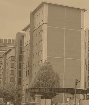
Brunswick Quad buildings follow a similar ordered aesthetic ,allowing their educational purpose to be easily identified through form, forming clustered through purpose . These buildings have a similar height to create a tranquil secluded peaceful environment, partially segregated from the busier pedestrian and transport routes either wide with Oxford Road acting as a central pathway into Manchester , acting the spine to which university buildings and clusters branch off. The park’s spaces are carefully designed with spaces between buildings with Unwinian principles with a fine balance between open spaces and nooks that are more intimate to establish a sense of repose and connection.


The symmetrical buildings act as portals, the regularity of buildings helps frame the architectural prowess of historic landmarks, establishing a sense of hierarchy along the street. The trees within the foreground with raised beds create undulations with the ground, establishing a sense of cohesion between the built and natural environment, between two prominent pathways and creating a natural order of progression and vertical distance, under Unwinian principles. Brunswick Park expresses Unwin’s vision of inter-twining functionality, beauty, and community. Trees adorn the surrounding spaces where people share conversations on benches, low-lying shrubs helping to enhance the human scale that risked being lost with the dominating surrounding buildings, where a fine balance is established. This demonstrates how sensitive design can enhance the human perception of space, transcending time, and spatial boundaries.


CALVINO’ STYLE’
reflection:
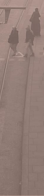
Cyclists glide the asphalt ribbon with meticulously practiced precision, their silhouettes effortlessly traversing the faint boundary between weary commuters and nonchalant amblers. Monoliths slowly trudge transits with a sense of indifference as destination and departure a blur , the pulse of the city beats with a silent synchrony. Complex lattices of movements weave footsteps like a tapestry of urban fabric in amongst variants of velocity. Here, Footsteps are a syncopated rhythm within the concerto of city life.
Personal narratives cast in the towering reflections of infrastructure ,culminations of glass ,brick and stone echoing airs of the fabric of time ,yet still sentinel they stand. Silhouettes blend effortlessly with sun rays piercing between the infrastructure’s crevices as silhouettes intertwine beneath the backdrop of concrete and glass; each their own protagonist in the transcendence of time. Their figures distant blurs succumbing to the marriage of innovation as the boundary between figure and facade becomes harmonised within artificial canyons of facades , bound by the complex interplay of angular geometry.
Raindrops create ballets of reflection upon the worn pavements , bearing witness to the surging waves of umbrellas, mere depictions of human’s ebb and flow of existence. Below the syncopated steps a newspaper flickers in the wind like a lantern in the depths of winter, it’s worn pages echoing disregarded dreams and aspirations, stories that suffocate in ignorance’s silence as it lay disregarded.
As rain lashes , wanderers seek solace beneath the overhangs of facade’s complex vertical labyrinths; their elusive shadows casting a partial dictation of congregations on the streets below, as the steady surge of people seek shelter, fleeting moments of tranquillity and comradery within the sanctuary of shelter, fleeting moments of eternity bound within the metropolis’s sacred heart.

MFRIEGHT ISLAND (FOCUS


BROWNFIELD SITE
PICADILLY TRAINS STATION
COMMUNAL ENTERTAINING AREA
FLAT COMMUNAL GREEN SPACE
CHILDRENS PARK
RESIDENTIAL HOUSING
OFFICE AND WORK SPACE
STUDENT ACCOMMODATION
HOTEL


ARDS FREIGHT ISLANDAND


reflection:


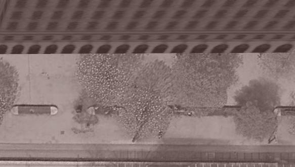
Built on one of Manchester’s former industrial heartlands the 6.5-acre Mayfield Park is the first public park built in Manchester in over a century, marking the desire for re-establishment of nature into bustling cities ; sanctuaries from city life as a prominent green lung for the city, increasing ecological diversity and restoration of riparian edges. Mayfield’s design strategy incorporates historic industrial artefacts from its station depot usage and mail distribution centre integrated into the contemporary landscape, the visualisation the natural restore with tangible reminders of the industrial past with cast iron beams woven within the landscape, indicating the re-emergence and harmony of nature with man.
Playing dynamic roles in people’s lives; Mayfield Park creates influxes and interactions of different demographics due to the diversity in peripheral building usages, exemplified in freight island (a popular cultural entertainment hub) opening onto the park and estate housing. The additional large children’s park (typically devoid in many areas within the central city,) amplifies the importance of nature for children in creating their future relationship to the environment ,shaping ways they live their future daily lives. Intertwining paths create networks of partially organic pathways encouraging free exploration. This is in stark contrast to the strict order of transport from the adjacent Piccadilly station.
A certain disparity is created between Mayfield park and piccadilly station exemplifying meticulous order; a deliberate replication attempt of nature under constraints, contrasting the hieracial order the meandering river has on the landscape in creating slower rhythms, embracing organic order , less impeding on well-being . Solace can be found from the cacophony of city life ,digital screens, and objectives. Delicate equilibriums are instigated where structure and natural life converge, the appreciation of both necessities in life .People’s attraction to the park is through leisure and not simply necessity of travel.


Utilised for over 36 million journeys in the 2022/23 financial year, is a significant determinant of pedestrian flow and navigation assisting reductions of an estimated 5 million cars annually to Manchester’s city centre, catalysing partial pedestrianisation, fundamentally changing both the efficiency of transport from predictability and encourages placemaking, enhancing people- centred spaces that improve people’s connection to the city through far more organic pedestrian flows between streets, not dictated by car’s linear route confines with transportation zoning. The system meanders existing city infrastructure to museums and points of attraction aiding functionality to improve the experience of the city as well as financial gain.
Designed to be accessible for all with low floor trams and step-free access, it serves as a place for social interaction during daily commutes where the impact has wide-reaching effects, increasing footfall outside businesses along its routes, most noticeably within the phase 3 corridors where many do not have access to cars, where surrounding footfall is increased. The Metrolink also is vital in reducing social inequality, allowing the less well-off to access city life and higher-income jobs. Around the central stops. Additionally, planning and development are often in close correlation with Metrolink routes catalysing the emergency of new commercial and residential hotspots.


https://andrewlainton.wordpress.com/2012/05/05/a-readers-guide-to-unwins-town-planning-in-practice-part-1-town-planning-as-an-art/