Winkfield Parish Neighbourhood Plan 2022-2037

Referendum Version
November 2023
November
1
WINKFIELD PARISH NEIGHBOURHOOD PLAN: REFERENDUM VERSION
2023
This page is left intentionally blank
2
WINKFIELD PARISH NEIGHBOURHOOD PLAN: REFERENDUM VERSION November 2023
Neighbourhood Plan 2022-2037
WINKFIELD PARISH NEIGHBOURHOOD PLAN: REFERENDUM VERSION November 2023 3 Winkfield
Referendum Version, November 2023 Contents Guide to Reading this Plan................................................................................................. 4 Foreword .............................................................................................................................. 5 List of Land Use policies....................................................................................................... 9 1 Introduction and Background 10 2 The Neighbourhood Area...........................................................................................13 3 Planning Policy Context..............................................................................................23 4 Community Views on Planning Issues 25 5 Vision and Objectives .................................................................................................31 6 Spatial Strategy ...........................................................................................................34 7 Design and Character 37 8 Housing.........................................................................................................................46 9 Community ..................................................................................................................51 10 Employment….. ...........................................................................................................54 11 Green Infrastructure/Environment 56 12 Promoting Sustainable Transport ...............................................................................78 13 Implementation ..........................................................................................................83 Policy Maps 85 Glossary and Abbreviations...............................................................................................89 Appendix A: Local Green Space maps ...........................................................................97 Appendix B: Schedule of Evidence 106
Parish
Guide to Reading this Plan
Of necessity, this Neighbourhood Development Plan (NDP) is a detailed technical document. The purpose of this page is to explain the structure and help you find your way around the plan.
1. Introduction & Background
This section explains the background to this Neighbourhood Development Plan and how you can take part in and respond to the consultation.
2. The Neighbourhood Area
This section details many of the features of the Parish of Winkfield and its facilities.
3. Planning Policy Context
This section sets out the wider planning policy context which informs the preparation of the NDP and with which the NDP must be in general conformity with. This includes the Government’s planning framework (the National Planning Policy Framework (NPPF)) and the documents that make up the development plan, published by Bracknell Forest Council.
4. Community Views on Planning Issues
This section explains the extensive community involvement which over the last few years, has helped to shape the vision, objectives, and individual policies of this Plan.
5. Vision and Objectives & Land Use Policies
This section provides a statement on the Neighbourhood Development Plan Vision and Objectives.
6-12. Land Use Policies
These sections detail policies which are proposed to address the issues in Section 4. These policies are listed on page 9. There are Policy Maps at the back of the plan and additional information in the Appendices to which the policies cross reference.
13. Implementation
This section explains how the Plan will be implemented and future development guided and managed. It identifies projects which might be funded, at least in part, by the Community Infrastructure Levy (CIL) which the Parish Council will gain receipts from and have some influence over. Finally, it deals with several issues which although relevant are outside the scope of a Neighbourhood Development Plan.
WINKFIELD
NEIGHBOURHOOD
November 2023 4
PARISH
PLAN: REFERENDUM VERSION
Foreword
The Civic Parish of Winkfield lies in the east of Berkshire and although less than 30 miles from central London it still retains its wonderful semi-rural character including many heritage sites and two conservation areas.
Geographically it is one of the largest parishes in the Country covering 9,609 acres, or 3,888 hectares. It has a population of approximately 15,000 people living in many separate villages and settlements – Cranbourne; Woodside; Cheapside; Maidens Green; Winkfield; Brock Hill; Winkfield Row; Chavey Down; North Ascot; Kings Ride; Martins Heron; The Warren and Forest Park.
With an abundance of open spaces, excellent schools, good access to London and the strategic road network, the Parish is a popular location to reside. However, this brings several challenges including the demand on our road network and other services such as doctors’ surgeries. There is also increased pressure to accommodate more development which is pushing the envelope of our existing villages out towards the countryside and Green Belt. 75% of the Parish is designated as Green Belt
Addressing the balance between meeting our community’s development needs and safeguarding what is important to our residents, the Government, has given local people more say about what goes on in their area through the Localism Act 2012 The creation of Neighbourhood Development Plans (NDPs) allows local communities to influence the planning of the area in which they live and work.
In 2015 the Parish Council considered the advantages of an NDP and agreed to develop the ‘Winkfield Neighbourhood Development Plan’. The Winkfield NDP is being led by a Steering Group formed for this purpose. It comprises members of local resident associations, the community, and the Parish Council. The NDP has been developed over the past 6 years with input from residents, local businesses, professional planning consultants, Bracknell Forest Council (BFC) and the Parish Council.
One of the first jobs undertaken by the Steering Group was to create a ‘Vision’ for Winkfield which reflects a large amount of background information (this is known as the ‘Evidence Base’) and encompasses the thoughts and feelings of the community, gathered through extensive consultation. The Steering Group were particularly grateful to the community for responding to its consultation which received a 21% response.
An Evidence Base Summary is available on the website (www.winkfieldnp.org).
The Plan sets out policy objectives on key issues such as community facilities and housing and employment, with the aim of retaining all that is good in Winkfield Parish and setting the boundaries for positive change. The overarching aim is to make Winkfield an even better place to live and work.
WINKFIELD PARISH NEIGHBOURHOOD
November 2023 5
PLAN: REFERENDUM VERSION
Whilst the NDP cannot be used to prevent development, it is a tool to shape development. The Steering Group decided that it should not allocate sites for housing development. Finding locations for development can be an extremely contentious issue which can often divide communities and railroad the real benefits of an NDP. As such, the NDP contains policies that cover a wide range of issues:
Policy W1 - A Spatial Plan for the Parish
Policy W2 - Promoting High Quality Design in the Character Areas
Policy W3 - Design of Parking, Garaging, Ancillary Buildings & EV charging points
Policy W4 - Housing type, size and choice
Policy W5 - Rural Exception Sites and Entry-Level Exception Housing
Policy W6 - Community Facilities
Policy W7 - Employment
Policy W8 - Biodiversity and Wildlife Corridors
Policy W9 - The Winkfield Row North/Winkfield Row South Local Gap
Policy W10 - Dark Skies
Policy W11 - Local Green Spaces
Policy W12 - Pedestrian/Cycle Network
Policy W13 - Martins Heron Station
It is important to appreciate that these policies should be read as a whole; the individual policies and proposals must not be considered in isolation from each other. Often several different policies will be applicable to a single development. In reaching decisions on planning applications, Bracknell Forest Council and others involved in the decision-making process will consider all the relevant plan policies, together with other material considerations. Other relevant policies include those set out in the Bracknell Forest Local Plan and the Government’s National Planning Policy Framework (NPPF) (2021).
Finally, we would like to express our thanks to everyone who has contributed to this Neighbourhood Plan and to our residents who have contributed through our consultation process. We hope our residents will continue to support the Plan through to Referendum and adoption of the Plan.
WINKFIELD
November
6
PARISH NEIGHBOURHOOD PLAN: REFERENDUM VERSION
2023
NDP Steering Group Members as of March 2022:
Name Administration
Liza Challis NDP Coordinator, Winkfield Parish Council
Steering Group Members Area Representing
Ivan Parr Chavey Down
Tracey Van Oeffelen Chavey Down
Dawn Thompson Forest Park
Melanie Trapnell Kings Ride, Co-Chair
Mark Fernandez Maidens Green/Winkfield
Roger Mulkern Martins Heron and The Warren
Keith Stephens Martins Heron and The Warren
Vicki Browne North Ascot, Parish Councillor
Heather Brown North Street, Cranbourne Co-Chair
Nigel Atkinson Parish Councillor
Moira Gaw Parish Councillor
Ruth Lyes Winkfield Row/Locks Ride
Former NDP Steering Group Members:
Name Administration
Annemarie Edwards Clerk, Winkfield Parish Council
Steering Group Members Area Representing
Richard Bell Maidens Green
Oliver Bettison Maidens Green
Suzanne Campbell North Ascot
Lynn Jenkins Forest Park Community Centre
Jacquie Lovell Chavey Down
David Parkin Chairman
Geoff Paxton Parish Councillor
Tony Pidgley The Cranbourne Society
Bruce Singleton North Ascot
Richard Small Kings Ride
Stuart Tarrant Parish Councillor
Lee Taylor Winkfield Row
Andrew Trapnell Kings Ride Residents Association
7
WINKFIELD PARISH NEIGHBOURHOOD PLAN: REFERENDUM VERSION November 2023
The Parish Council has supported the Steering Group from its inception.
Parish Councillors as of June 2022:
Chairman – Emily Blyth
Vice Chairman – Ian Harvey-Brown
Nigel Atkinson
Olivio Barreto
Gerry Barber
Vicki Browne
Terry Blakemore
Karl D’Souza
Peter Frewer
Victoria Griffin
Moira Gaw
Dorothy Hayes
Angela Michie
Geoff Paxton
Derek Wall
Robert Warren
Former Parish Councillors active during the preparation of the NDP:
Aghdas Cullen
Christopher Foxon
Charlie Laver
Sue Luker
Mark Fernandez
Stephen Mitchell
David Lindop
David Parkin
Jordan Masters
Bob Shurville
Stuart Tarrant
Susie Phillips
Pat Denhert
Sarah Cottle
Cat Tilbury
Sara McKay
Sue Rayment
Colin Yates
Roberta Kaye
Nikos Polydorou
WINKFIELD
8
PARISH NEIGHBOURHOOD PLAN: REFERENDUM VERSION November 2023
List of Land Use policies
WINKFIELD PARISH NEIGHBOURHOOD PLAN: REFERENDUM VERSION November 2023 9
W1 A Spatial Plan for the Parish 34 Design and Character W2 Promoting High Quality Design in the Character Areas 37 W3 Design of Parking, Garaging, Ancillary Buildings and EV charging points 45 Housing W4 Housing type, size and choice 46 W5 Rural Exception Sites and Entry-Level Exception Housing 48 Community W6 Community Facilities 51 Business/Employment W7 Employment 54 Green Infrastructure W8 Biodiversity and Wildlife Corridors 56 W9 The Winkfield Row North/Winkfield Row South Local Gap 60 W10 Dark Skies 63 Promoting Sustainable Transport W11 Local Green Spaces 64 W12 Pedestrian/Cycle Network 78 W13 Martins Heron Station 82
1 Introduction and Background
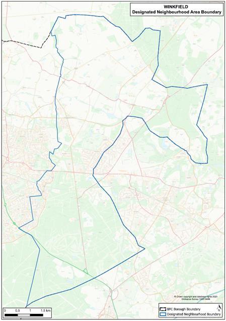
1.1 Winkfield Parish Council (WPC) has prepared a Neighbourhood Development Plan (NDP) for the area designated by the local planning authority, Bracknell Forest Council (BFC) in July 2023, under the provisions of the Localism Act 2011 and of the Neighbourhood Planning (General) Regulations 2012 (as amended) The Neighbourhood Plan area was originally designated in December 2015 and covered the Parish of Winkfield, as defined at that date. However, during the Examination, minor changes were made to the boundary of Winkfield Parish, which took effect from 2 March 2023. As a result, Winkfield Parish Council applied to the Council to amend the designated area to remove three small areas of land which now fall within an adjoining parish. The amended area was designated by the Council as a Neighbourhood Area on 14 July 2023. Therefore, the Plan relates to the amended designated Neighbourhood Area shown in Figure 1.1 below.
WINKFIELD PARISH NEIGHBOURHOOD
VERSION November 2023 10
PLAN: REFERENDUM
Figure 1.1: Designated Winkfield Neighbourhood Area
1.2 The purpose of the WNDP will be to make planning policies that can be used to determine planning applications in the area. Its policies will aim to protect the special character of the Parish and to encourage development proposals for the benefit of the local community. The Plan period is 2022 to 2037.
1.3 NDPs provide local communities with the chance to shape the future development of their areas. Once approved at a referendum, the NDP becomes a statutory part of the Development Plan for the area and will carry significant weight in how planning applications are decided by Bracknell Forest Council.
1.4 NDPs can only contain land use planning policies. This often means that there are important issues of interest to the local community that cannot be addressed in an NDP as they are not directly related to planning e.g., antisocial behaviour. The Parish Council will endeavour to work with our communities to address such issues through other means.
1.5 Although there is considerable scope for the local community to decide on its planning policies, NDPs meet some ‘basic conditions’ as set out by the Government. They must ensure that:
• It is appropriate to ‘make’ the plan; having regard to national policies and advice contained in guidance issued by the Secretary of State.
• The ‘making’ of the plan contributes to the achievement of sustainable development;
• The making of the plan is in general conformity with the strategic policies contained in the development plan for the area of the authority;
• The making of the plan does not breach, and is otherwise compatible with, EU obligations; and
• Prescribed conditions are met in relation to the plan and prescribed matters have been complied with in connection with the WNDP.
1.6 In addition, Winkfield Parish Council must be able to show that it has properly consulted local people and other relevant organisations during the process of making its NDP and has followed the 2012 Neighbourhood Planning Regulations (as amended).
1.7 These requirements have been tested by an independent examiner following the Winkfield NDP submission (Regulation 16) consultation. The examiner has recommended to Bracknell Forest Council, that subject to modifications set out in the final report, the plan goes to referendum of the local electorate. If the referendum is successful (which requires a simple majority of those voting), the WNDP will form part of the Bracknell Forest Development Plan and will be used in the determination of planning applications relating to land in the Winkfield neighbourhood area.
WINKFIELD PARISH NEIGHBOURHOOD PLAN: REFERENDUM VERSION November 2023 11
Strategic Environmental Assessment & Habitats Regulations Assessment
1.8 The Parish Council requested a screening opinion from Bracknell Forest Council in respect of the need for a Strategic Environmental Assessment (SEA)to be prepared1. Bracknell Forest Council’s Screening Opinion was issued in August 2016. It concluded that there was a requirement for an assessment given the contents of the Plan. The intention to allocate sites for development may have significant environmental effects.
1.9
Since the publication of this Screening Opinion the NDP is no longer intending to allocate any housing. However, an SEA is still required as the NDP supports development outside the settlement boundary, including in the Green Belt, in certain circumstances, going beyond the support provided for such development by other applicable policies. As such the outcome of the Screening Opinion is considered to remain valid A draft SEA Report was therefore published alongside the Pre-Submission Plan.
1.10
As part of the preparation of the WNDP, the Steering Group also needed to consider whether a Habitats Regulation Assessment (HRA) was also required. Seeking advice from Bracknell Forest Council, the HRA Screening Report concluded that significant effects are likely to occur with regards to the integrity of the European sites within and around Bracknell Forest Borough, due to the implementation of the WNDP. As such the WNDP requires an HRA to be undertaken.
1.11 The Appropriate Assessment was prepared in May/June 2022 and addresses these matters accordingly. Policies W5, W6 and W7 and/or the text that supports them make appropriate provision to mitigate potential impacts on the Thames Basin Heaths Special Protection Area (SPA). As a result, it has been concluded that the NDP will have no adverse effect on the integrity of habitats sites, either alone or in combination with other plans and projects.
1 A Strategic Environmental Assessment (SEA) is required under the EU directives 42/2001 and the 2004 Environmental Assessment of Plans and Programmes Regulations
WINKFIELD PARISH NEIGHBOURHOOD PLAN: REFERENDUM VERSION November 2023 12
2 The Neighbourhood Area
An Overview of Winkfield Parish
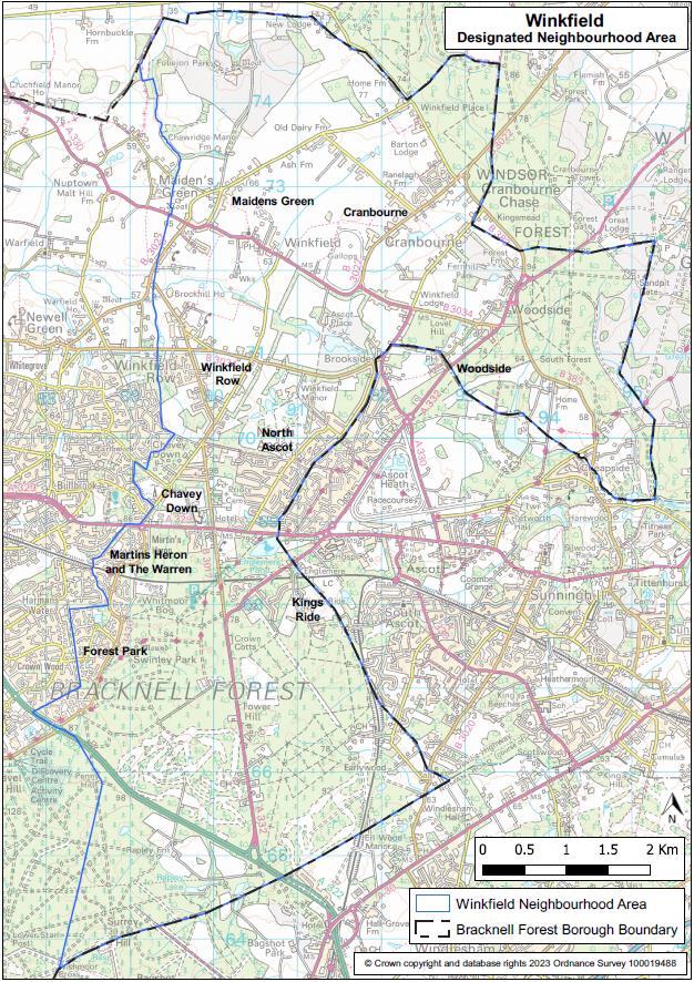
2.1 Winkfield is a Civil Parish, which lies on the eastern edge of the Bracknell Forest Council administrative area and covers 3,888 hectares (15 sq. miles). Geographically it is one of the largest parishes in England. The area has a population of approximately 15,000 people occupying 6,531 homes (Census 2011).
2.2 Our residents live in many separate villages and settlements – Cranbourne; Woodside; Cheapside; Maidens Green; Winkfield; Brock Hill; Winkfield Row; Chavey Down; North Ascot; Kings Ride; Martins Heron; The Warren, and Forest Park (see Figure 2.1).
WINKFIELD PARISH NEIGHBOURHOOD
REFERENDUM VERSION November 2023 13
PLAN:
Figure 2.1: Winkfield Parish – Designated Neighbourhood Area Boundary
2.3 To avoid confusion on settlement and village naming, Table 2.1 identifies the differences between the names used by Winkfield Parish Council, residents and businesses and those used in the Bracknell Forest Local Plan. Where appropriate, the ‘local’ name has been used and the settlement name conferred by Bracknell Forest used only when quoting from the BFC Local Plan. In order for the WNDP to be in general conformity with the strategic policies of the Local Plan, it is necessary for policies to use the name in the BFC Local Plan.
Table 2.1: Winkfield Parish Village and Settlement Names
Settlement name used by WNDP and residents
Brock Hill
Chavey Down
Chavey Down East (The Village) *
Chavey Down West *
Cheapside
Settlement name used by Bracknell Forest Local Planning
Brock Hill
Chavey Down
Cheapside
Cranbourne North Street (Cranbourne)
Cranborne North Street*
Lovel Road *
Forest Park
Kings Ride * (covering Prince Consort Drive and Prince Albert Drive)
Cranbourne, Lovel Road
Forest Park (for the purposes of BFC local planning, within the settlement of Bracknell Town)
Prince Consort Drive
Maidens Green Maidens Green/Winkfield Street
Martins Heron & the Warren Martins Heron & the Warren (for the purposes of BFC local planning, within the settlement of Bracknell Town)
North Ascot
North Ascot – North*
North Ascot -South*
Winkfield
Winkfield Row
Winkfield Row North *
Locks Ride
Chavey Down Road *
Woodside
North Ascot
Church Road, Winkfield
Winkfield Row - North
Winkfield Row - South
Woodside
* Indicates the name of the Character Assessment carried out for the WNDP
2.4 To the north and east of Winkfield Parish is the administrative area of the Royal Borough of Windsor and Maidenhead (RBWM) and the extensive area of Windsor Forest. Situated within the RBWM, adjoining the boundary of our Parish are the parishes of Sunninghill & Ascot and Sunningdale whose NDPs, were
WINKFIELD
November 2023 14
PARISH NEIGHBOURHOOD PLAN: REFERENDUM VERSION
among the first tranche to be adopted in April 2014. To the west of Winkfield Parish are the Parishes of Warfield and Bracknell Town. The Warfield NDP and Bracknell Town NDP are both ‘made’. To the south of the Parish lies the Borough of Surrey Heath and the village of Bagshot.
Our Residents - Who We Are, How We Live & What We Do
2.5 There were 14,998 usual residents on Census day 2011. The average (mean) age of our residents was 38.2 years. On Census day, the age breakdown of our resident population was as follows: 3,494 (23.3%) 0-17-year olds; 9,590 (63.9%) 18-64-year olds (‘working age population’); and 1,914 (12.8%) 65+ year olds. Our residents generally consider themselves to be in ‘good’ or ‘very good’ health (88%) with only 4.5% of residents considering their day-to-day activities to be ‘limited a lot’.
2.6 In total there were 6,532 household spaces in 2011. Of these, 6,288 (96.3%) had at least one usual resident and 244 (3.7%) had no usual residents e.g., vacant properties. Most households live in a house / bungalow (83%) followed by a flat, maisonette or apartment (11.8%) and caravan, mobile home, or other temporary structure (5.2%). The availability of houses / bungalows is dominated by detached properties (41%), followed by semi-detached properties (33%) and terraced properties (26%).
2.7 The household composition of the Parish is mostly one household families (65%) with just under half of those having dependent children. 30% of households within the Parish consist of only 1 person. Surprisingly though single households are not dominated by those 65 years and above. Rather, 20.4% of single households are occupied by someone under 65 years. The average household size is 2.3 people whilst the average household has 5.7 rooms with an average 2.8 bedrooms.
2.8 Our housing market is predominately made up of homeowners, with 29.8% of households owning their property out right and a further 45.8% owned with a loan or mortgage. The private rented sector also has a role within our housing market, providing accommodation for 16.2% households. Census data shows a distinct lack of affordable homes within the Parish. Less than 1% of households live in shared ownership accommodation whilst only 6% of households live in social rented accommodation.
2.9 Reflective of a housing market dominated by houses that are mostly detached properties and an area with very limited affordable housing stock, house prices in the area are high. At a glance, the overall average price of homes sold in the last year (2021) in Maidens Green was £1,411,200. This was more expensive than neighbouring areas such as Chavey Down (£671,998);
WINKFIELD PARISH NEIGHBOURHOOD PLAN: REFERENDUM VERSION November 2023 15
North Ascot (£519,606), and Winkfield Row (£664,792). Prices of properties sold across Winkfield Parish are more expensive than nearby Bracknell (£386,492) and Warfield (£463,402) but were cheaper than Ascot (£891,462) (Rightmove).
2.10 The Parish is home to some 11,000 aged between 17 and 74. Of those 78.9% are economically active and in employment. Most residents work full-time (59.1%) whilst 3.9% work part-time and 16.2% are self-employed. Unemployment levels are low within the Parish at 2.7%.
2.11 Our residents (those aged 16 and above) are well-educated with 35.6% having level 4 qualifications (degree level or above). In total, 86.4% of our residents (those aged 16 and above) have some form of qualification including apprenticeship with only 13.6% having no qualifications.
2.12 Our residents work in a variety of industry sectors. The top three are: wholesale and retail trade; repair of motor vehicles and motorcycles (13.8% of residents aged 17 – 74); information and communication (10.9%) and education (10.1%). Positions that our residents hold are in the higher level of occupations including professional occupations (21.3% of residents in employment aged 16 to 74); associate professionals and technical occupations (17.1%) and managers, directors, and senior officials (15.1%).
2.13 We have a highly mobile population with 92.3% of households owning 1 or more vehicles (car or van). This brings issues, adding to our congested road network.
Our Business Community
2.14 Winkfield Parish is predominately a residential area serving the local economic centres of Bracknell, Ascot, Slough, Windsor, and Maidenhead and elsewhere. Nevertheless, a small number of businesses operating within the Parish do offer local employment opportunities and / or act as local convenience destination or a place to meet. The majority of these operate in small retail parades or in stand-alone accommodation as opposed to on larger-scale business or retail parks.
2.15
Employment opportunities within the Parish range from small independent establishments such as shops, restaurants, public houses, liveries and vehicle repair / MOT centres, to larger scale operations, such as building merchants, market garden centres, and even national employers including Tesco, Mercedes and Shorts Agriculture. A business audit undertaken by the Steering Group in April 2016 identified 37 businesses of varying types operating throughout the Parish.
WINKFIELD PARISH NEIGHBOURHOOD PLAN: REFERENDUM VERSION November 2023 16
2.16 Single shops / small shopping parades offering local convenience goods are in Forest Park and North Ascot (Warren Row and New Road).
How Our Residential & Business Communities are Connected
2.17 The A332 connects the Parish to the London Road and the M3 southwards, the B3022 to Windsor and Slough to the north east, and the A330 to Maidenhead to the north west and the M4. Running through the centre, the A329 London Road splits the Parish in half and connects Bracknell Town Centre with Ascot High Street and many other towns further afield.
2.18 The Parish lies within a diamond formed by the M4, M3, M25 and the A322/A329(M). Traffic between the M3 and M4 motorways uses the network of roads within the Parish which creates high traffic flows high at peak times. The busy Bracknell Northern Distributor Road with fast moving traffic terminates at Long Hill Road and Binfield thus playing a major part in contributing to the speed and volume of traffic that then comes through the older, semi-rural villages to the North of the Parish on unsuitable, sometimes very narrow roads not designed for this purpose.
2.19 New Forest Ride runs through the length of Martins Heron, The Warren and Forest Park from the A329 and connects to the A322. This effectively serves as a link road between the M3 and M4 motorways, acting as the “rat run” which feeds onto Long Hill Road and onwards to the villages in the North of Winkfield Parish as road users find routes to Slough, Windsor the M4 and M25. New Forest Ride continues to get busier and, together with most of the roads in the Parish, often comes to a standstill during the morning rush hour period.
2.20 The Parish is served by a train station at Martins Heron and is hugely popular with commuters from areas far exceeding Winkfield, Ascot and Bracknell. The daily footfall brings problems as most users arrive by car and vie for one of only 34 spaces serving the station. The remaining overspill then takes over all available spaces within the residential area and beyond. The station’s platforms have been extended to accommodate two additional carriages at peak times. Journey times are 20 minutes to Reading and 55 minutes to Waterloo.
WINKFIELD PARISH NEIGHBOURHOOD
REFERENDUM VERSION November 2023 17
PLAN:
Our Services and Facilities
2.21 Located within the Parish are several community services and facilities that are enjoyed by our residents and others from further afield. These include:
• 12 community centres or halls
• 1 public library
• 3 leisure/sports facilities
• 13 outdoor playgrounds
• 8 nurseries/Early Years settings/pre-schools
• 6 schools (3 of which are independent schools) – all the state schools in the Parish are primary schools
2.22 Other community services and facilities located within the Parish area include shops, places of worship, nursing homes, cafes, public houses and restaurants, pharmacies and post offices. There are no GP services located within the Parish.
2.23 Most community services and facilities are located in North Ascot (33%) followed by Winkfield Row (17%), Cranbourne (15%), Chavey Down (10%), Forest Park (10%), Martins Heron (6%), Winkfield (5%), Maidens Green (2%) and Woodside (2%).
2.24 Within 5 miles of the centre of the Parish are several National Attractions: Legoland, Lapland UK (seasonal openings) and Ascot Racecourse which also host events and large music concerts. Against this backdrop the Parish is fighting to maintain its woodland and environmentally sensitive heritage.
Our Built & Natural Environment
2.25 The Parish has a rich built and natural environment which shapes the character of the area, provides the setting for our villages and is protected by local and national policies.
2.26 A significant feature of our settlements is the number of historic buildings. A number of these are listed - 94 buildings, most of which are Grade II listed. The exceptions to this are:
• Grotto in the grounds of Ascot Place, to the south of house at west end of lake – Grade I
• Ascot Place – Grade II*
• Church of St Mary – Grade II*
• St Leonards Dale – Grade II*
• New Lodge – Grade II*
WINKFIELD
November
18
PARISH NEIGHBOURHOOD PLAN: REFERENDUM VERSION
2023
(Grade definitions - Grade I: buildings of exceptional interest, Grade II*: particularly important buildings of more than special interest and Grade II: buildings that are of special interest, warranting every effort to preserve them.)
2.27 The Parish also contains an entry on the National Register of Parks and Gardens of special historic interest in England, published by English Heritage in 1987. This is the grounds of Ascot Place, Winkfield.
2.28 There are two conservation areas in Winkfield Parish. These are Winkfield Row and Winkfield Conservation Areas. Winkfield Row Conservation Area is the latest area to be designated in the Borough (13 December 2005). The focus of Winkfield Conservation Area is Church Road. The Area was designed on 12 May 1977.
2.29 Another feature of the Parish’s rich built environment is several Scheduled Monuments. A Scheduled Monument is an historic building or site that is included in the Schedule of Monuments kept by the Secretary of State for Culture, Media and Sport. The Regime is set out in the Ancient Monuments and Archaeological Areas Act 1979. The Scheduled Monuments in Winkfield Parish are:
• Moated site at Foliejon Park.
• Moated site at Winkfield Lane
• Bowl barrow in Swinley Park – 390 meters south-east - National Grid Reference: SU 89106 67551
• Two sections of Roman Road in Bramshill Forest between Roman Star Post and Ropley Lane.
2.30
New development throughout the WNDP area should protect assets of the historic environment (designated or non-designated) and enhance or reinforce those characteristics, qualities and features that contribute to the local distinctiveness of the NDP area's environment. Proposed development immediately adjacent to or directly affecting heritage assets or assets on the Historic Environment Register (HERs), as defined in the NPPF within the NDP area must pay special regard to preserving or enhancing its setting and any special architectural or historic features of significance it possesses.
2.31 All development proposals should also aim to sustain, reinforce and conserve the historic aspects and special character of locally distinctive elements of the area. This includes taking account of, protecting and enhancing, important views, landmarks and local points in the area.
2.32 Our natural environment is equally important in shaping our Parish. Within the Parish area are Sites of Specific Scientific Interest (SSSIs) An SSSI is a
WINKFIELD PARISH NEIGHBOURHOOD PLAN: REFERENDUM VERSION November 2023 19
conservation designation denoting a protected area in the United Kingdom and Isle of Man. The SSSIs are:
• Swinley Park & Brick Pits in Bracknell Forest (covering two areas).
• Englemere Pond (also a designated Local Nature Reserve by Natural England)
• Chawridge Bourne.
• Windsor Forest & Great Park
• Broadmoor to Bagshot Woods and Heath.
2.33 The Thames Basin Heaths Special Protection Area (SPA) impacts planning decisions in most areas of the Parish. Designated in March 2005 for its lowland heathland, it supports significant populations of three ground-nesting birds: The Nightjar; Woodlark; and Dartford Warbler. The Thames Basin Heaths SPA Buffer Zone falls within the Parish and as a result any net increase in residential development within the buffer zone is required to mitigate against recreational pressure on the SPA.
2.34 Designated under the Habitats Directive, the Windsor Forest & Great Park Special Area of Conservation (SAC) is situated in the north-east of Winkfield Parish. Together with the Special Protection Area (SPA) these areas are part of the national site network and are internationally important for threatened habitats and species.
2.35 Winkfield is susceptible to flooding from a variety of different sources including ‘The Cut’, a major watercourse that meanders through the Parish and eventually joins the River Thames at Bray. Whilst providing an attractive backdrop, surrounding areas are liable to flood. Nearly the entire Parish is considered a ‘Nitrate Vulnerable Zone’. There are also some areas at risk from surface water and also from ground water flooding.
WINKFIELD
November 2023 20
PARISH NEIGHBOURHOOD PLAN: REFERENDUM VERSION
Winkfield Spatial Portrait
2.36 Since Bracknell’s inception as a new town, the population of the Borough has grown rapidly from 23,408 in 1951 to 120,377 in 2017 (mid-year population estimate). This is one of the highest growth rates in the country and growth over more recent years has led to pressure on infrastructure and services. Additional development pressure on areas beyond the built-up area of north Bracknell have resulted in the continuing ‘squeeze’ of the ‘countryside gap’ which lies between the built-up area of north Bracknell and the Green Belt. Despite this, Winkfield Parish is largely rural, consisting of several settlements and villages either surrounded or washed over by Green Belt or Countryside.
Existing Settlements
2.37 There are three communities within the Parish Area which are defined by Bracknell Forest Council as settlements in the Local Plan. These are: North Ascot, Chavey Down, and Winkfield Row. In addition, the communities of Martins Heron & The Warren and Forest Park which are within the Parish boundary on the eastern edge of the Bracknell Town. Each of these areas is inset from the Green Belt / Countryside and has its own defined boundaries. These areas have been tested by Bracknell Forest Council against a set of criteria to assess their role and function, including whether there are certain facilities and services to help sustain our existing communities and help support any future growth across the Borough.
2.38 As shown on the Policy Map, the three settlements of North Ascot, Chavey Down and Winkfield Row are clustered in a central area within the Parish, sitting between the A329 London Road to the south and the A330 Church Road to the north. Dividing the three settlements are areas of land designated as Green Belt or Countryside.
Metropolitan Green Belt
2.39 Approximately 75% of the Parish area is designated as Green Belt. Land designated as Green Belt extends from the southern to the northern boundaries of the Parish, east of the A332 and B3017 skirting the southern edge of Chavey Down and encircling North Ascot. Extending further north, land beyond ‘The Cut’ and out towards Cranbourne and Woodside is designated Green Belt.
2.40 The purposes of Green Belt policy are to check the unrestricted sprawl of large built-up-areas to prevent neighbouring towns from merging into one another to assist in safeguarding the countryside from encroachment; to preserve the
WINKFIELD PARISH NEIGHBOURHOOD PLAN: REFERENDUM VERSION November 2023 21
setting and special character of historic towns and to assist in urban regeneration by encouraging the recycling of derelict and other urban land.
2.41 Green Belt located within Winkfield Parish contains several settlements / villages, agricultural / horticulture small holdings, equestrian facilities and recreation / play areas. Defined settlements within the Green Belt are: South Ascot (part). Green Belt Villages are Brock Hill; Maidens Green / Winkfield Street; Church Road, Winkfield; North Street, Cranbourne; Cranbourne, Lovell Road; Woodside and Prince Consort Drive.
Countryside
2.42 Land designated as countryside extends from the southern boundary of the Parish, west of the A332 and B3017 (Swinley Road) and moving north west of Locks Ride and Braziers Lane. The Cut forms the boundary between land designated as Green Belt and countryside. Land designated as countryside surrounds the defined settlement of Chavey Down / North Road; Chavey Down / Long Hill Road; and Winkfield Row.
Local Gaps
2.43 Within the NDP area, Bracknell Forest Council has identified a Strategic Gap between Bracknell and North Ascot in its emerging Local Plan. The core function of the gap is to prevent Bracknell and North Ascot from coalescing, both physically and visually. Being close to / adjoining defined settlement, the area is subject to significant development pressure. If lost, it could potentially lead to the merging of settlements and the loss of individual settlement identity. However, the Local Plan Inspectors’ Post Hearing letter (January 2023) includes a main modification to delete the strategic gaps policy as the modified Policy LP37 Landscape Character and LP35 Development in the Countryside are considered to provide clarity and adequate protection to ensure that the distinctive character of the setting of settlements is not eroded.
2.44 Building on the concept of gaps, the NDP identifies a further ‘local’ gap that is considered essential to prevent the merging of the northern and southern parts of Winkfield Row (see Policy W9)
WINKFIELD
NEIGHBOURHOOD
VERSION November 2023 22
PARISH
PLAN: REFERENDUM
3 Planning Policy Context
3.1 Informing the preparation of the WNDP is a host of other policies and advice issued by the Government and Bracknell Forest Council. As set out in the Government’s ‘basic conditions’ when a community prepares a Neighbourhood Plan, it is important that:
• Regard is given to national policies and advice contained in guidance issued by the Secretary of State; and
• The ‘making’ of the WNDP is in general conformity with the strategic policies contained in the development plan for the area.
National Planning Policy
3.2 The revised National Planning Policy Framework (NPPF) published by the Government in 2021 provides national policy guidance that has informed the preparation of the Winfield Parish NDP. In this regard, the WNDP must be consistent with this national policy.
3.3 Also, of relevance in the preparation of the WNDP is the national Planning Practice Guidance published by Government.
3.4 At the local level, the relevant development plan for the area currently comprises saved policies of the Bracknell Forest Borough Local Plan (2002), Bracknell Forest Core Strategy (2008) and the Site Allocations Local Plan (2013). The WNDP policies must be in general conformity with the strategic policies within these plans.
3.5 The weight that the WNDP attaches to each policy may vary depending on the extent to which the policy is consistent with the NPPF.
3.6 The Parish Council is mindful, that the new Local Plan to cover the period to 2037 will replace the saved policies of the Local Plan early in the lifetime of the WNDP.
3.7 Setting out a vision, objectives and strategy for the level and distribution of development in the Borough up until 2037, a pre-submission consultation on a revised growth strategy was undertaken by Bracknell Forest Council between March and May 2021. BFC then submitted the draft Local Plan for public examination in December 2021. Following Examination, adoption of the Plan is estimated to be in late-2023.
WINKFIELD PARISH NEIGHBOURHOOD PLAN: REFERENDUM VERSION November 2023 23
3.8 Within the emerging Local Plan (Pre-Submission Version, March 2021), Bracknell Forest Council has set out its strategic planning policies with which the WNDP must be in conformity with. These have informed the development of the WNDP. Focusing on the development of new homes, the Pre-Submission Local Plan proposes two allocations for the Parish. However, one of the sites (WINK34 Land to the rear of Forest View and Oriana, Longhill Road and west of Fern Bungalow, London Road) is now a commitment and no longer proposed for allocation. There is a proposed main modification to delete the site. See Table 3.1.
3.9 In the case of some policies, it will be essential that the WNDP and new Local Plan are mutually supporting, and the Local Plan’s reasoning and evidence has been taken into consideration in the preparation of the WNDP, in line with national Planning Practice Guidance.
Table 3.1: Winkfield site allocations in the Bracknell Forest Council PreSubmission Local Plan, March 2021 (reflecting proposed modifications to the Local Plan)
WINKFIELD PARISH NEIGHBOURHOOD PLAN: REFERENDUM VERSION November 2023 24
Site Reference Location Proposed Units (net) WINK15 Whitegates, Mushroom Castle, Winkfield Row 42
4 Community Views on Planning Issues
4.1 On 18th November 2015 Winkfield Parish Council (WPC) established the Winkfield Neighbourhood Development Plan (WNDP) working party, known as the WNDP Steering Group. Winkfield being the second largest Parish in England has nine separate parish settlement areas, so two leaders per settlement area (18 in all) were drawn from those nine local resident associations with powers to co-opt. Specific vision statements were drawn up and topic groups formed to process, research, canvass, develop, consult, listen and report.
Involving Our Residents
4.2 The Parish Council has consulted with the local community during the Plan preparation process, and the WNDP is based upon the results of these consultations, which have included meetings, open days and community surveys.
4.3 Key consultation initiatives organised by the steering group have included:
• In 2016 a Parish-wide resident questionnaire was hand delivered to every household (in total just over 6,500 dwellings) with a freepost response. The document explained why we need a Neighbourhood Plan and, requested the views of residents An online version was also published.
• To assist with the 2016 questionnaire, an independent survey consultant was employed to help us with the important task of formulating questions across a broad spectrum Results published in January 2017 showed we had a participation response of 21% (1,413 valid responses), a higher percentage response rate than the national average to similar consultations.
• In November 2017 two exhibitions took place. Locations and timings were selected to maximise attendance. Over the course of the 18th and 25th November (both weekend dates), updates on the progress of the WNDP were provided and 12 questions posed on presentation boards which sought further views from the community on key topics. Steering Group leaders were in attendance to explain and assist with questions. A general response form for feedback which could be answered at the time with assistance on hand or taken away if preferred, was available. 90 responses were received.
WINKFIELD PARISH NEIGHBOURHOOD PLAN: REFERENDUM VERSION November 2023 25
• In May 2017 and 2018 there was an exhibition of the WNDP at the local Chavey Down Residents Association AGM. In June 2017 at the Cranbourne Village Event there was an exhibition for the afternoon which was manned by representatives of the WNDP steering committee with a good response from local residents.
• In addition, a website for the WNDP has been established (www.winkfieldndp.org). This sets out information on the vision for the area, statements on each of the areas covered by the plan and information of each of the topic areas the plan cover. All agendas and minutes of the Steering Group meetings are published on the website.
• The Steering Group has also provided regular updates via the Winkfield Parish Council Newsletter which is circulated quarterly to every household across the Parish area. Newsletters are also published on the WNDP website.
• Via each consultation method, the Steering Group has provided the opportunity for new volunteers to come forward.
The Views of Our Community
4.4 The results of the 2016 questionnaire were published in February 2017 in a document titled ‘Summary Report on the 2016 Neighbourhood Development Plan Survey’. A summary document of the responses received during the November 2017 exhibitions was also published. As captured in the summary documents, the key headlines from these two events are outlined below.
Design & Character
Overall, there were five main elements which were considered to have the most positive impact in contributing to the character of the area:
• Easy access to natural woodland and open spaces (77% of respondents said ‘very’ positive).
• Mature trees, hedgerows and shrubs (71% of respondents).
• A rural feel (67% of respondents).
• Outside garden space, front and rear of properties (62% of respondents)
• Off-street car parking (56% of respondents).
WINKFIELD
November 2023 26
PARISH NEIGHBOURHOOD PLAN: REFERENDUM VERSION
4.5 Traditional housing design, well-designed street furniture, the protection of historic buildings, and provision of recycling storage are also considered strong net contributors to the character of the area. A third of respondents expressed that ‘innovative design and modern style buildings’ as well as ‘gated communities’ detract from the character of the area.
4.6 In order not to detract from the character of the area, 79% of respondents agreed (40%) or strongly agreed (39%) that garages require specific policy management. For the same reasoning, 85% of respondents agreed (44%) or strongly agreed (41%) that extensions should require specific policy management.
4.7 It was clear from those respondents making general comments that the character and design of the area are extremely important to residents. 67% of respondents mentioned the need to preserve the natural character & rural feel of the area, open space, Green Belt, fields, and trees. Managing any development design carefully with respect to our heritage was also referred to. Concerns about squeezing new housing developments into areas which will struggle to sustain them was also a thread voiced by many.
Housing
4.8 A mismatch between the current and emerging housing needs of the community and the type of properties available within the Parish was cited as a concern by several respondents.
4.9 Homes being too big or too small were both mentioned as issues. However, the most common difficulty expressed was the ability to access suitable accommodation which is at the right price to buy or rent (53% of respondents). Subsequently, the type of new homes mentioned as being the priority for delivery over the next 20 years were Affordable Housing, Starter Homes and 2 and 3-bedroom units (to address issues of downsizing).
4.10 In addition, due to our ageing population, it was also felt that Specialist Housing for the Older Population should be encouraged. To address the issue of homes being too small, 63% of respondents also stated that minimum internal space standards in new homes should be encouraged.
4.11 Very few respondents felt that there was a need for luxury housing costing £1m + (8% of respondents) or houses with 5+ bedrooms (13% of respondents). There was little appetite for flatted development of more than three storeys (3% of respondents).
WINKFIELD PARISH NEIGHBOURHOOD PLAN: REFERENDUM VERSION November 2023 27
4.12 Overall, there was a recognition that some new housing development was required within the Parish area. In terms of accommodating such development, 63% of respondents felt that it was preferable to provide homes on small sites of fewer than 10 homes. Nevertheless, there was a strong motion that infill development was having considerable impact on facilities and services and that additional GP (89% of respondents), school (68% of respondents) and childcare (66% of respondents) facilities were required.
Community Facilities
4.13 Residents greatly value the existing communal facilities and assets generally available and wish to protect and improve them. As indicated above, it was strongly expressed that development within the Parish was having a considerable impact on community facilities and that additional facilities were required.
4.14 Respondents listed several facilities that they considered important to the local community. These included: a pharmacy, post office, recreational green outdoor space, general store / newsagents, children’s equipped play areas, and library facilities. Also mentioned as important community facilities which acted as places to meet were public houses/cafes/restaurants/hotels, play areas/sporting grounds, garden centres, and places of worship.
4.15 Overall, respondents are satisfied with the access they have to certain community facilities (ranging from 60% - 83%). However, it was felt that there was scope for improving access to meeting places and activities for the younger population.
Business/Employment
4.16 Continuing the theme of where people like to meet, the types of businesses that respondents felt should be encouraged in the Parish area included pubs, cafes and restaurants (more than three quarters of respondents). There was also support for encouraging retail provision (37% of respondents), shared workspace (43% of respondents) and start-up provision (37% of respondents). Nevertheless, it was felt that for the latter to be successful improvements in broadband, mobile phone service and improved transport links would be required.
4.17 Conversely, a few comments stated that since the Parish is predominantly a residential area, they would not like to see too many businesses developed, certainly not large businesses or retail chains.
WINKFIELD PARISH NEIGHBOURHOOD PLAN: REFERENDUM VERSION November 2023 28
Green Infrastructure/Environment
4.18 Not surprisingly, nearly everyone (97% of respondents) agreed that in Winkfield Parish, local green spaces (e.g., Locks Ride Recreation and Sports Ground and Long Hill Park) must be retained for healthy recreational activities whilst 91% of respondents also agreed that recreational green outdoor spaces are important. 53% of respondents also agreed with the proposition that there should be more provision for allotments within the Parish.
4.19 A strong majority (81% of respondents) agreed that Winkfield Parish needs improved safe off-road bicycle routes to surrounding areas/towns. 79% of respondents agreed that there is a need to improve the quality and connectivity of local footpaths.
4.20 Feedback from all our consultations has shown very strong support for retaining the separation between our villages as being critical to protecting the semi-rural, non-urban character of the area. Overall, most residents would support the adoption of the 2006 proposal from Bracknell Forest Council for a local gap so that Bracknell and Ascot would remain separated by a green strip of land stretching from Winkfield Row to Martins Heron, preventing Bracknell merging with Ascot (88% of respondents agreeing, including 71% of respondents agreeing strongly).
4.21 In terms of Green Belt, 78% of respondents either disagreed (24%) or strongly disagreed (54%) with allowing development of protected areas. While residents accept that some limited development must be allowed, 77% of respondents wanted the access to our many green open spaces to be retained.
4.22 Our last Options Consultation defined six gaps between different villages and asked respondents whether they would support all or some. There was strong support for protecting all of them, ranging from 65% to 70% of respondents. Most of the land in these gaps is in the Green Belt although there are areas which are not.
Highways/Parking/Traffic
4.23 Several significant concerns regarding highways, parking and traffic were expressed by respondents throughout the consultation process. In terms of highways, 80% of respondents believe that the local authority should take a far more strategic approach to such issues in the Parish. Overall, 77% of respondents agreed that plans should be made for major highway improvement works.
WINKFIELD PARISH NEIGHBOURHOOD PLAN: REFERENDUM VERSION November 2023 29
4.24 Focusing on specific locations, two key areas were identified as being most in need for junction improvements and to which funds should be directed. These were Braziers Lane/Forest Road/Locks Ride (the location of several vehicle accidents) and Brock Hill/Maidens Green Crossroads (this was realigned early in 2021 but currently there is no recent data to confirm the improvements). In order to improve the network of pavements, it was also felt that funds should be directed to Forest Road, Locks Ride and Long Hill Road.
4.25 51% of respondents agreed with the proposition that there is a car parking problem in Winkfield Parish and that new housing developments are exacerbating the issue further. Two key aspects of car parking were expressed: on-street or pavement parking (poor, inconsiderate and often dangerous) and the need for increased car parking at Martins Heron railway station.
4.26 Tackling the issue of traffic, there were mixed views as to the potential of traffic calming measures. 52% of respondents considered that more is needed whilst 30% of respondents disagreed. Areas where respondents felt there was the highest need for traffic calming measures were Brock Hill, Maidens Green, North Ascot New Road area and Winkfield.
4.27 Although the majority (58% of respondents) felt that the local road network should be a priority for infrastructure investment, several respondents stated that having more and better roads will simply encourage more vehicles and cause traffic issues. As such, a balance is required.
Summary
4.28 The Steering Group realise from the many informed views received from our community that while we must accept some change, change must not damage the strong and diverse natural and built environment that is paramount to the whole of Winkfield Parish.
4.29 Key areas for this WNDP to address are housing needs of our community; the protection of our most valued areas including our open spaces, countryside, and Green Belt; and improving accessibility across the Parish including the provision of more sustainable modes of transport.
WINKFIELD PARISH NEIGHBOURHOOD PLAN: REFERENDUM VERSION November 2023 30
5 Vision and Objectives
Vision
5.1 In response to the views of the community, the evidence gathered on the existing facilities and profile of the population and the planning policy context in the Local Plan. The following vision for Winkfield Parish in 2037 has informed the development of the WNDP:
“In 2037 Winkfield has retained its villages and hamlets separated by countryside gaps and the essential character of the Green Belt has been preserved. Development has been well-designed and contributes positively to the visual character of the local surrounding’s heritage. Community facilities and services have survived and flourished. The special environmental assets of the Parish have been preserved and the community has benefitted from access to and enjoyment of the countryside.”
Objectives
5.2 To achieve this vision several key objectives have been identified as follows:
A. To promote high quality design and ensure that the design of new development contributes positively to the visual heritage and landscape character of the local surroundings,
B. To safeguard the integrity of Winkfield’s distinct settlements by protecting the gaps between them,
C. To meet the housing needs of the Parish by supporting a mix of housing types and tenures to ensure that development works for everyone and has good access to services,
D. To secure the long-term future of community, cultural, educational, and recreational facilities,
E. To encourage new local employment and retail opportunities within settlements,
F. To maintain and enhance the quality and abundance of environmental assets and ensure that there are no significant effects on the Thames Basin Heath SPA and Windsor Forest and Great Park SAC,
G. To increase the number of local journeys undertaken on foot, cycle or by public transport,
H. To reduce the harmful impact of road traffic on the Parish.
WINKFIELD PARISH NEIGHBOURHOOD PLAN: REFERENDUM VERSION November 2023 31
5.3 The WNDP recognises the need to successfully absorb a modest amount of additional housing and employment provision. Ideally, residents wish to see this provided on previously developed land. However, 75%+ of the Winkfield Neighbourhood Plan area is covered by Green Belt and much of the remaining land is subject to strategic gap policy, within open countryside (away from settlements) or covered by woodland. National planning policy continues to afford robust Green Belt protection.
5.4 After extensive community engagement by the WNDP Steering Group (NPSG) it has been firmly established that there is a strong preference for consideration of small-scale housing developments rather than one or two large sites as they are easier to integrate and are less likely to damage the existing character of the various settlements or put pressure on the existing infrastructure.
5.5 Subject to no conflict with the detailed design guidance of this document, the WNDP wishes to be permissive of non-strategic small development sites (<0.5 hectare) which are brownfield or within or adjacent to the boundaries of settlements (outside the Green Belt) Such development should be sustainable and secure a wider range of types and tenures of new homes to serve local needs.
5.6 Despite a "Call for Small Sites" in 2017 and further analysis of smaller sites identified by Bracknell Forest Council in their own studies, the WNDP Steering Group has been unable to identify any suitable or deliverable sites that could be considered for allocation for development. Most of the sites proposed are within the Green Belt whilst the remainder are considered too remote from settlements, not sustainable or in conflict with the emerging Local Plan’s strategic gap policy.
Monitoring & Review Policies
5.7 The WNDP will be monitored by WPC using data collected in planning monitoring reports. The objectives will form the core of the monitoring activity, but other data collected and reported at a Parish level relevant to the Plan may also be included. It is expected that the WNDP will be formally reviewed on a five-year cycle or to coincide with the development and review of the Borough’s Development Plan, if this cycle is different.
WINKFIELD PARISH NEIGHBOURHOOD PLAN: REFERENDUM VERSION November 2023 32
Land Use Planning Policies
5.8 Land use policies are used to determine planning applications made for development proposals. They can establish the principles for retaining or changing the use of land in settlements and in the countryside. They can also set out the conditions against which development proposals will be judged in terms of their design, access etc.
5.9 The purpose of these policies is to either encourage planning applications to be made for things the local community wants to see happen or to discourage inappropriate applications for developments that do not meet the community’s objectives (as articulated in the WNDP’s objectives). Policies must be clearly written so they can be easily applied when considering planning applications.
5.10 The plan deliberately avoids repeating existing national or local planning policies. The proposed policies therefore focus on a relatively small number of key development issues in the area. For all other planning matters, the national and local policies of other planning documents - The National Planning Policy Framework and the policies of the Bracknell Forest Development Plan will continue to be used.
5.11 Set out in the chapters that follow are the proposed policies of the Plan. Each policy has a number and title and the policy itself is written in bold italics for ease of reference. There is also a short statement explaining the intention of the policy and any other relevant background information. At the end of this document are the Policy Maps - where a policy refers to a specific designation or area then it is shown on the Maps.
5.12 It is important to appreciate that these policies should be read as a whole; the individual policies and proposals must not be considered in isolation from each other. Often several different policies will be applicable to a single development. In reaching decisions on planning applications, Bracknell Forest Council and others involved in the decision-making process will consider all the relevant plan policy’s, together with other material considerations. Other relevant policies include those set out in the Bracknell Forest Borough Local Plan and emerging Local Plan and the Government’s National Planning Policy Framework (NPPF) (2021).
WINKFIELD PARISH NEIGHBOURHOOD PLAN: REFERENDUM VERSION November 2023 33
6 Spatial Strategy
Policy W1: A Spatial Plan for the Parish
A. New development must reflect and deliver sustainable growth supported by high quality infrastructure, whilst respecting the unique character of the Parish and the local distinctiveness of individual settlements and villages.
B. The Parish’s green infrastructure network, strategic and local gaps and other open spaces within the settlement areas will continue to play a key role in shaping settlements and development patterns over the plan period. The multi-functional role of the green network will continue to be protected and its enhancement will be supported.
C. The following spatial strategy principles must inform development proposals in the Parish:
1. New development is directed predominantly to the settlement areas outside of the Green Belt.
2. Development on brownfield land will be supported where it delivers the objectives of the Neighbourhood Plan.
3. Within the Green Belt villages of Cheapside; Cranbourne; Church Road, Winkfield; North Street; Cranbourne and Maidens Green/Winkfield Street, development will be restricted to limited infilling within their village boundaries, as shown on the Policy Map. Infill development should be appropriate to the scale of the locality.
4. Within the countryside (land outside the defined settlements, outside village boundaries and outside the Green Belt), development proposals will be permitted where they are consistent with national planning policy and the relevant policies in the development plan. As appropriate to their scale, nature and location development proposals should protect and where practicable enhance the intrinsic character and beauty of the countryside and quality of the Landscape Character Area within which they are located.
5. Development proposals should demonstrate how the character of the area has been taken into consideration, and that valued landscape functions relating to the separation of settlements will not be compromised, including on a cumulative basis.
6. Within the Green Belt, development will only be permitted where it is consistent with the BFC Local Plan and national planning policy.
WINKFIELD
November 2023 34
PARISH NEIGHBOURHOOD PLAN: REFERENDUM VERSION
6.1 Setting out a clear spatial strategy is key to the delivery of the vision and objectives of the Parish. New development must deliver overall benefits to, and take account of, the local distinctiveness and character of the area. It should also be delivered in tandem with good quality infrastructure and services that, in some areas, is already under pressure. The challenge is to plan for new development whilst maintaining people’s quality of life.
6.2 As set out in Section 2 of this Plan, through extensive public consultation residents have consistently voiced their desire to protect the countryside and Green Belt and other open spaces in the settlement areas. The results of extensive community engagement during the preparation of the WNDP has also indicated that infill, or small-scale development, is preferred to large scale development, providing it is sympathetic to the character of the villages.
6.3 Drawing together these key points and, within the framework of national planning policy and BFC’s Local Plan (both existing and emerging), this policy aims to balance needed growth with the desire to preserve the local character of the Parish and our network of open spaces.
6.4 In accordance with BFC’s Local Plan, development will be directed to the settlement areas within the Parish: North Ascot, Chavey Down, Winkfield Row. In addition, the communities of Martins Heron & The Warren and Forest Park which are within the Parish boundary on the eastern edge of Bracknell Town. Each of these areas is inset from the Green Belt/Countryside and has its own defined boundaries. These areas have been tested by Bracknell Forest Council against a set of criteria to assess their role and function, including whether there are certain facilities and services to help sustain our existing communities and help support any future growth across the Borough. The purpose of directing development to these settlements is so that the remaining countryside around them is protected. Green Belt policy along with the identification of a Local Gap between Winkfield Row North and Winkfield Row South (in Policy W9) further protects these areas.
6.5 The Green Belt villages identified in Policy W1 will continue to be washed over by the Green Belt. However, a boundary around the villages has been identified to allow development which is restricted to limited infilling. For the purposes of this policy, limited infilling is the development on a small gap in an otherwise continuous built-up frontage, or the small-scale redevelopment of existing properties within such a frontage.
WINKFIELD PARISH NEIGHBOURHOOD PLAN: REFERENDUM VERSION November 2023 35
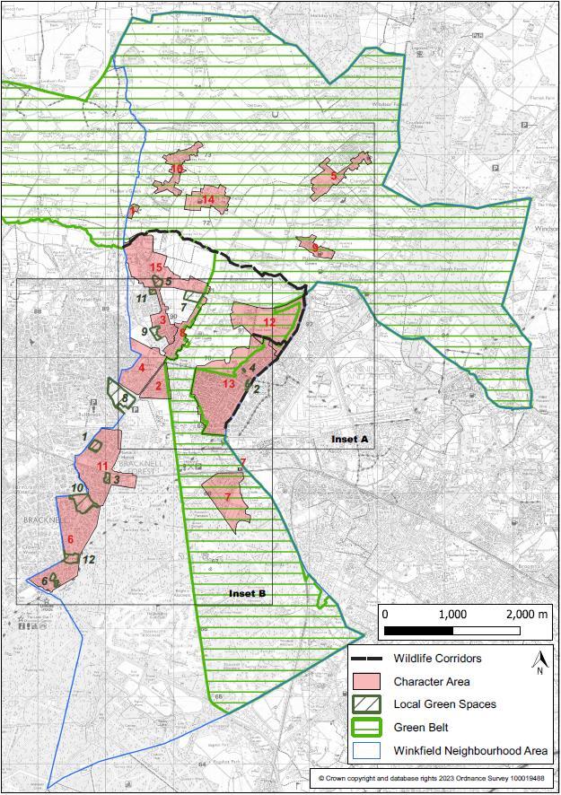
6.6 Consideration of the intrinsic character and beauty of the countryside will be based upon the valued features and characteristics of the Landscape Character Area in which the development scheme is proposed. These are set out in the Bracknell Forest Landscape Character Assessment (LCA) (September 2015) and the Recommendations Report (September 2015). These reports show that areas of countryside located within the Parish area are divided into five Landscape Character Areas:
• Forest Sands (A1)
• Winkfield & Cranbourne Clay Farmland (C2)
• Chavey Down Wooded Sands (F1)
• Sunninghill Woodland Estate (G2)
• Great Windsor Park (H1)
6.7 The designation of a Local Gap (in Policy W9) will not necessarily prevent development. Proposals within the defined Gap will need to demonstrate that the landscape functions relating to the separation of settlements have not been compromised.
6.8 National and local planning policies recognise the intrinsic character and beauty of the countryside. Countryside areas within the Parish provide an attractive landscape setting for the settlements and its links with ecological and green corridor networks in urban areas. National policy also refers to proposals contributing to the natural and local environment, being sympathetic to local character, including the surrounding landscape setting, and establishing and maintaining a strong sense of place.
Delivers Plan Objectives: All
WINKFIELD PARISH NEIGHBOURHOOD
REFERENDUM VERSION November 2023 36
PLAN:
7 Design and Character
Policy W2: Promoting High Quality Design in the Character Areas
A. Development proposals should deliver a high quality of design, use of high quality materials and reflect the character of the surrounding area.
B. Proposals for development will be supported provided they demonstrate appropriate regard to the character area within which they are located (as shown on the Policy Map). When located on or close to a boundary between character areas, the character of the neighbouring area must also be taken into account. Proposals should also reflect the design principles in the relevant Character Area Assessment, as summarised below:
1. Brock Hill
• Boundary treatment on road frontages should maintain the pattern of open frontages and low walls.
• Proposals must not have a detrimental impact on the functioning of existing traffic calming measures and, where appropriate, should contribute to further improvements.
2. Chavey Down East (The Village)
• The style and form of development proposals should reflect the prevailing variety of building types and plot sizes.
• Merging of plots should be avoided unless it can be demonstrated that it would not destroy the small-scale characteristics of the area and eliminate glimpses of woodland areas between the plots.
• Boundary treatment on road frontages should maintain the pattern of small picket fences, railings, low hedges and/or walls.
3. Chavey Down Road
• Development proposals should reflect the pattern of building forms, plot widths and orientation along the road.
• Where appropriate, proposals should maintain the predominant pattern of gardens backing on to open countryside and woodland.
• Boundary treatment should retain and reinforce the prominence of mature trees and hedgerows in front gardens.
4. Chavey Down West
• Development proposals should reflect the strong feeling of the transition from suburban fringes to open countryside provided by low-density development surrounded by planting.
• Proposals should reflect the scale and massing of existing developments and their curtilage and, where appropriate, retain glimpses to countryside.
WINKFIELD PARISH NEIGHBOURHOOD PLAN: REFERENDUM VERSION November 2023 37
5. Cranbourne North Street
• The style and form of development proposals should reflect the present variety of building types and plot sizes with an open feel at the southern area moving into a more developed central area and northern end.
• Boundary treatment on road frontages should maintain or enhance the contribution of existing high hedges and mature trees to the street scene.
6. Forest Park
• Development should reflect the style, scale and massing of buildings in the surrounding area.
• Boundary treatment should maintain the pattern of varying sizes of frontages with an emphasis on soft landscaping.
7. Kings Ride - Prince Consort Drive and Prince Albert Drive
• Development proposals should reflect the distinctive character of existing lowdensity development set in dense woodland.
• Boundary treatment on road frontages should maintain or enhance the contribution of trees, shrubs, and hedges to the street scene.
8. Locks Ride
• Development proposals should reflect the pattern of building forms, plot widths and orientation.
• Trees and hedges that inform the verdant character of the street scene should be retained.
• Where trees are no longer considered to be healthy, similar scale (at maturity) native species should be planted to maintain consistent green frontages.
• Proposals should reflect the scale and massing of existing developments and their curtilage, and where appropriate, seek to maintain glimpses of outlying fields and woodland.
9. Lovel Road
• Development proposals should reflect the pattern of building forms, plot widths and orientation.
• Proposals should not reduce the open aspect that Cranbourne Primary School and Elliott Court provide to the centre of the village.
• Boundary treatment on road frontages should reflect the pattern of defined frontages with low hedges or walls.
WINKFIELD PARISH NEIGHBOURHOOD PLAN: REFERENDUM VERSION November 2023 38
10.
• The style and form of development proposals should reflect the building types and plot sizes of the particular part of the Character Area (namely, the old village, the centre, and the Brock Hill area).
• Boundary treatment on road frontages should maintain the pattern of grass verges and hedgerows.
• Development proposals will be required to demonstrate that they will have no harmful effects on heritage features including the old moat, the field pattern and woodland that contribute to the historic character of the settlement.
11.
• The style and form of development proposals should reflect the present variety of building types and plot sizes.
• Development proposals should maintain the pattern of high walls and fencing (in The Warren) and soft landscaping (in Martins Heron) that protects the New Forest Ride from visual intrusion by development.
• Proposals should maintain and, where possible, enhance the existing network of pedestrian paths and cycle ways and the contribution of green open space surrounded by tall trees and shrubs.
12.
• Development proposals should reflect the pattern of building forms, plot widths and orientation on either side of the road, including retaining or providing gaps between buildings, that provide glimpses to outlying woodland.
• Boundary treatment on road frontages should maintain the pattern of wide pavements and verges and open frontages with low walls, hedges, or fences.
• Proposals will be required to demonstrate that they have no harmful effects on the historic parkland features of the long driveways to the Golf Course and Winkfield Manor (where appropriate) which contribute to the character of the landscape.
13.
• Development proposals should reflect the pattern of similar building forms, plot widths and orientation.
• Boundary treatment on road frontages should maintain or enhance the contribution of trees and hedges to the street scene.
• Proposals must not have a detrimental impact on the functioning of existing traffic calming measures and, where appropriate, should contribute to further improvements.
WINKFIELD PARISH NEIGHBOURHOOD PLAN: REFERENDUM VERSION November 2023 39
Maidens Green
Martins Heron and The Warren
North Ascot North
North Ascot South
14. Winkfield
• Development proposals should reflect the pattern of similar building forms, plot widths and orientation.
• Development on the eastern side of the character area should retain the semirural character of well-spaced ribbon style mixed development.
• Development on the western side of the character area, should retain the set back of buildings and sense of enclosure leading to the more open Church area in the core of the Character Area.
• Proposals should maintain the predominant pattern of gardens backing on to open countryside.
• Development in the Winkfield Conservation Area, and its setting, must demonstrate that it has had regard to the Winkfield Conservation Area Appraisal and Management Plan 2008.
15. Winkfield Row North
• Development proposals should reflect the pattern of similar building forms, plot widths and orientation in the particular part of the Character Area, i.e., the open feel in the northern area and the more built up feel in the southern area.
• Boundary treatment on road frontages should maintain or enhance the contribution of high hedges and mature trees to the street scene.
• Development in the Winkfield Row Conservation Area and its setting must demonstrate that it has had regard to the Winkfield Row Conservation Area Appraisal and Management Proposals 2008.
• Proposals must not harm the contribution that the Lambrook School frontage and the King George V playing fields make to the open character of this part of the area.
WINKFIELD
NEIGHBOURHOOD
November 2023 40
PARISH
PLAN: REFERENDUM VERSION
7.1: Winkfield Character Areas
Key – Winkfield Character Areas
1. Brock Hill
2. Chavey Down East (The Village)
3. Chavey Down Road
4. Chavey Down West
5. Cranbourne, North Street
6. Forest Park
7. Kings RidePrince Consort Drive and Prince Albert Drive
8. Locks Ride
9. Lovel Road
10. Maidens Green
11. Martins Heron and The Warren
12. North Ascot North
13. North Ascot South
14. Winkfield
15. Winkfield Row North
WINKFIELD PARISH NEIGHBOURHOOD
November 2023 41
PLAN: REFERENDUM VERSION
Figure
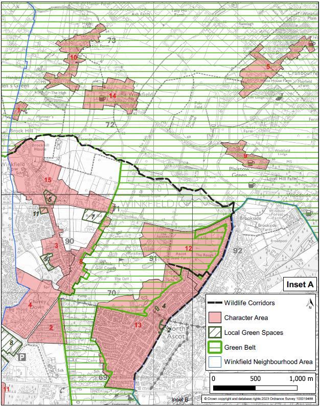
WINKFIELD PARISH NEIGHBOURHOOD
REFERENDUM VERSION November 2023 42
PLAN:
Figure 7.2: Winkfield Character Areas – Inset A

WINKFIELD PARISH NEIGHBOURHOOD PLAN: REFERENDUM VERSION November 2023 43
Figure 7.3: Winkfield Character Areas – inset B
7.1 This policy establishes the key design considerations that development proposals need to address according to which part of the Neighbourhood Area they are located in.
7.2 The local community has prepared fifteen Character Area Assessments in Winkfield Parish (see the Evidence Base) to identify the key characteristics that define the distinctive parts of each part of the Neighbourhood Area. These are shown in Figures 7.1 to 7.3 above. For each area, the appraisal describes its history and how the area appears now in terms of any dominant or common features of buildings, plots, spaces, and landscape. If a proposal does not intend to follow the requirements of the policy, applicants will be expected to demonstrate why other material considerations apply.
7.3 The policy requires that applicants should demonstrate that they have had regard to the specific principles it identifies, as well as the design guidance relevant to the location of their proposals contained in the Assessments.
7.4 The intention of this design management policy is to provide a set of principles that set out the quality of development that will be expected for each character area and to reflect the wishes of the community as stated in the 2016 survey.
7.5 It does not prevent or discourage innovation in architectural forms or detail, but it is important that any new development demonstrates a connection with local character and place making. The overriding consideration should be whether the new build harmonises with its setting. This will be achieved by using guidance set out in the Character Area Assessments (2018) which should be read in conjunction with this Plan.
7.6 This reflects Draft Local Plan Policy LP15 (Design Principles) which sets out high quality design principles for all development and establishes the importance of enhancing the distinctiveness of local character. Related matters such as parking standards and residential amenity are not addressed in Policy W2 because they are already addressed through BFC’s Local Plan policy. However, the design of parking provision is addressed in Policy W3.
Delivers Plan Objectives: A, B, and F
WINKFIELD PARISH NEIGHBOURHOOD PLAN: REFERENDUM VERSION November 2023 44
Policy W3: Design of Parking, Garaging, Ancillary Buildings and EV charging point provision
The provision of parking, garaging or ancillary buildings and electric vehicle charging points should be incorporated sensitively within development proposals and their landscaping by ensuring that:
i. the design and layout is visually subservient to the main property and not obscure or dominate the house frontage or approach; and
ii. the visual impact on the wider streetscape is softened with adjacent planting.
7.7 The purpose of the policy is to inform the design of parking to reduce its impact on the streetscape by the use of strong soft and/or hard landscaping, architecture, and boundary treatment, such that parking does not dominate the street scene and reflects guidance issued by the Chartered Institute of Highways and Transportation. This recognises that many of the Character Area Assessments identified parking as an issue which detracts from the character of Winkfield.
7.8 Most car owners like to be able to see their vehicles and/or to know that they are securely parked. ‘In-curtilage’ parking (i.e., on a driveway or in a car port or garage) usually satisfies this strong desire. Where possible therefore, the design and layout of parking should be an integral part of the overall plot layout and should take into account the context of the wider street scene. Furthermore, good materials and landscaping are likely to be maintained by occupiers, whereas poorly considered schemes may be subject to insensitive alterations, especially in the case of additional space for parking being provided by residents in their gardens. Such considerations also need to take into account the requirement for all new properties to provide electric vehicle (EV) charging points.
7.9 The community indicated that poor and inconsiderate on-street and pavement parking remains an issue in the Parish. This is particularly evident in the Forest Park Area. Developments will be expected to demonstrate how these needs will be satisfactorily met with a focus on highway safety and on reducing the impact of parking on the character of the street scene.
Delivers Plan Objective: A
WINKFIELD PARISH NEIGHBOURHOOD PLAN: REFERENDUM VERSION November 2023 45
8 Housing
Policy W4: Housing type, size and choice
A. Proposals for new residential development should address the most up to date local housing needs. On sites of five or more dwellings, at least 80% of the dwellings should be a mix of 1, 2 and 3-bedroom homes. Sites delivering two, three or four dwellings should provide at least one home of 1, 2 or 3-beds.
B. Alternative housing mixes will only be supported where there is clear evidence to support such an approach on design, layout, viability, or housing need grounds.
C. Development proposals that provide the following types of residential accommodation will also be encouraged:
• Homes specifically developed for private rent.
• Undeveloped, serviced plots made available individually for purchase by self-builders; and
• Sheltered, extra care, and registered care provider provision.
8.1 Community consultations have shown that local people have difficulty in finding suitable homes in the Parish and that homes for first-time buyers and specialist housing for older people were the most needed. The housing mix proposed in the policy therefore reflects this local need for smaller (1-3 bed homes). This is supported by the Bracknell Forest Housing Needs Assessment 20212 which suggests that for the northern parishes (Binfield, Winkfield and Warfield), the following mix of homes is delivered:
Bracknell Forest Housing Needs Assessment 2021, Table
WINKFIELD
November 2023 46
PARISH NEIGHBOURHOOD PLAN: REFERENDUM VERSION
1bedroom 2bedrooms 3bedrooms 4+bedrooms Market 5% 30% 33% 32% Affordable home ownership 26% 44% 20% 10% Affordable housing (rented) 30% 37% 29% 3%
2
Table 8.1: Modelled mix of housing by size and tenure in the northern parishes
Source:
8.9
Iceni Projects Ltd (2021) Bracknell Forest Housing Needs Assessment, for Bracknell Forest Council
8.2 The Housing Needs Assessment confirms a view of many in the local community that the average cost of market housing (to buy or rent) in Bracknell Forest is well beyond the means of many local young people and families and typical of the challenge faced by these groups in meeting their housing needs throughout the Thames Valley. In this regard, the identification of higher requirements for small (1-3 bed) dwellings in the affordable home ownership sector is more representative of the local need. This suggests that 90% of homes built for affordable home ownership should be 3 bedrooms or fewer.
8.3 Bracknell Forest Draft Local Plan Policy LP24 (Housing mix) states that developments of fewer than 10 residential units will be encouraged to provide types and sizes of dwellings that reflect local needs. With the exception of the proposed site allocation at Whitegates in Winkfield Row (WINK15) for 42 dwellings, the vast majority of windfall developments are likely to be below this threshold. It is vital therefore that they address the local needs in Winkfield.
8.4
As set out in Draft Policy W2, development proposals will need to be carefully designed taking account of the design principles relevant to the character area assessment within which they are located It is acknowledged that not all schemes will lend themselves to the provision of smaller dwellings. Therefore, this will be judged on a site-by-site basis. It is also acknowledged that whilst there is a preference for smaller homes, this policy does not preclude the provision of 4+ bedroom homes. A need for such homes remains and their provision may be more appropriate dependent on the character of the area and on issues of financial viability.
8.5 To ensure that the desired housing mix of smaller homes is achieved i.e., 1, 2 and 3-bedrooms, all rooms provided on the first floor, and above which meet the local and/or national bedroom standard and are capable of providing a bedroom, will be counted as such. This includes for example, rooms labelled as ‘study’ and ‘games room’. It will not apply to bathrooms.
Delivers Plan Objective: C
WINKFIELD PARISH NEIGHBOURHOOD PLAN: REFERENDUM VERSION November 2023 47
Policy W5: Rural Exception Sites and Entry-Level Exception Housing
Rural Exception Sites
A. Small-scale rural exception housing schemes which would meet a local housing need will be supported. This need must be identified through a local needs survey for the Parish. Any provision of market housing to support the affordable provision must be accompanied by a robust and clear viability appraisal.
B. The affordable housing within the scheme must remain affordable in perpetuity.
C. Schemes must consider their potential impact on the local character, their relationship with the existing settlement and the wider landscape.
Entry Level Exception Sites
D. Proposals for the development of entry-level homes suitable for first time buyers or those looking to rent their first home will be supported on land which is not already allocated for housing, provided:
i. the scheme comprises entry-level homes that offer one or more type(s) of affordable housing as defined by the NPPF,
ii. the scheme is adjacent to an existing settlement boundary and proportionate in size to the existing settlement (sites should not be larger than one hectare in size or exceed 5% of the area of the existing settlement within its boundaries),
iii. the layout, massing and height of the buildings are designed in such a way as to avoid compromising the Winkfield Row North/Winkfield Row South Local Gap; and
iv. the scheme reflects the requirements relating to design and character in Policies W2 and W3 and in the Local Plan.
Habitats Mitigation
E. Development proposals shall include measures to mitigate the impact of a net increase in residential development upon the Thames Basin Heaths Special Protection Area (SPA) in agreement with the Council and Natural England. This will include a financial contribution towards Suitable Alternative Natural Greenspace (SANG) and Strategic Access Management and Monitoring (SAMM) and any other measures that are required to satisfy Habitats Regulations, the Bracknell Forest Council Thames Basin Heaths SPA avoidance and mitigation strategy and relevant guidance.
WINKFIELD PARISH NEIGHBOURHOOD PLAN: REFERENDUM VERSION November 2023 48
8.6 The aim of this policy is to enable small scale development to come forward in the context of the new National Planning Policy Framework. It reflects the community’s aspiration for small scale development that will deliver affordable homes for first-time buyers, as provided for by paragraphs 72 and 78 and Annex 2 in the NPPF if proposals reflect the character of the local surroundings.
8.7 This policy is also cognisant of the challenge of providing such homes in Bracknell Forest as described in the Housing Strategy for Bracknell Forest 2018 –2036. The Strategy acknowledges the need for a proactive strategy to influence the local housing market given that housing costs in Bracknell and neighbouring areas for both purchasing and renting are generally high, reflecting the buoyancy of the local economy and proximity to London.
8.8 Rural exception housing is allowed for within the terms of the NPPF as an exception to policy. Whilst the WNDP Call for Sites did not identify any sites outside the Green Belt that would be suitable for allocation, there were possible sites within the Green Belt which could come forward as rural exception sites.
8.9 Any such schemes are intended to be small in scale and meet an identified need established in a parish housing needs study for affordable housing for a settlement or parish (or group of villages) to which the proposal relates. Local need is restricted to meeting the needs of households that have an existing connection with the area e.g., who are either current residents or have an existing family or employment connection. It is expected that rural exception sites will, in most cases, deliver 100% affordable housing. In some cases, a proportion of market housing may be acceptable where this enables the closing of a funding gap for the delivery of the affordable housing within the scheme. The market homes should be integrated with the affordable homes to form a single scheme. Where market housing is being used to financially support rural exception schemes, the following detailed evidence is required:
i. a financial appraisal demonstrating the viability of the scheme and the financial relationship between open market and affordable housing,
ii. the measures being taken to ensure the use of the affordable housing is to meet local needs in perpetuity,
iii. the relationship of open-market housing to meeting local needs in terms of location, design, visual character, and type of accommodation
8.10 Rural exception housing schemes should be well related to the existing settlement and care should be taken to ensure that they do not result in isolated development in the countryside because of the impact on landscape character of the area and access for occupants to public transport, education and other essential facilities including for example, access to foul drainage infrastructure.
WINKFIELD PARISH NEIGHBOURHOOD PLAN: REFERENDUM VERSION November 2023 49
8.11 Housing being brought forward based on overriding local need must be accompanied by a statement setting out the evidence both of the need (a local needs survey) and to justify a particular location. The evidence must be sufficient to demonstrate that a genuine need exists and how the proposed development intends to meet that need. The development must be designed and developed as part of one cohesive scheme.
8.12 A rural exception site may include an element of open market housing to help with funding the scheme. However, this must be clearly justified. If a rural exception scheme requires an element of market housing, there is a presumption that the development will have the least amount of open market housing required to help finance the scheme. The number of market houses will depend on the individual circumstances and be assessed on a site-by-site basis. If open market housing dominates the housing mix, then the scheme no longer qualifies as rural exception housing and will be contrary to policy. The proportion of market houses should be small in relation to the overall number of housing units proposed on the rural exception site. Open book accounting will be required as part of any approval.
8.13 A detailed submission will be required which sets out why any open market housing element is necessary, how the scale of market housing proposed supports the funding of the rural exception housing and why alternative funding mechanisms have not been used, including Parish receipts from Community Infrastructure Levy (CIL) payments. The overriding consideration is the exceptional need for local affordable housing, and it must be shown that the scheme provides housing for local households in perpetuity.
8.14 Winkfield Neighbourhood Development Area lies within the Thames Basin Heaths Special Protection Area Buffer Zones and therefore a net increase in residential development within the 400m - 5km SPA buffer zone, may create additional recreational pressure. The policy therefore seeks financial contributions towards SANG and SAMM, and other measures that are required to ensure proper mitigation. This could also include measures to ensure that proposals resulting in a net increase car parking within 400m of the Thames Basin Heaths Special Protection Area cannot be made available to the general public wishing to access the SPA.
Delivers Plan Objective: C
WINKFIELD PARISH NEIGHBOURHOOD PLAN: REFERENDUM VERSION November 2023 50
Policy W6: Community Facilities
A. Development proposals to maintain or extend the viable use of existing community facilities or to expand provision either through expansion of an existing facility or the development of a new facility will be supported. This includes the provision of outdoor leisure facilities, including sports pitches, play areas and recreational equipment.
B. Proposals to establish a new doctor’s surgery and/or a new dentist facility will be supported, provided they are located outside the Green Belt and have sufficient off-street car parking spaces.
9.1 Winkfield has a broad range of community facilities. Figure 9.1 shows the location of community buildings as of January 2022.
9.2 Existing BFC Local Plan policy already protects community facilities from being lost, requiring proposals to demonstrate that they are no longer needed or to re-provide them in a suitable location elsewhere. The policy in the WNDP seeks to encourage providers of community facilities to expand provision where it is necessary. This could be in the form of expansion of an existing facility or provision of a new facility. The policy applies to all community facilities, not just those owned by the Parish Council.
9.3 The WNDP steering group has collected evidence on community facilities within the Parish that are valued by the community and offer a valuable resource to support community life as evidenced in the Community Facilities Topic Group Evidence Report (Feb 2018).
9.4 The policy uses a broad definition of community facilities. They are not only considered to be buildings in community use but also outdoor spaces where provision is made for community activities. This may include sports pitches, which whilst not necessarily needing planning permission to be provided, may need permission for supporting facilities such as changing rooms or pavilions. It also covers play areas and outdoor leisure provision such as outdoor gyms.
9.5 The policy also supports proposals for health services provision, so the local community does not have to travel as far as at present to access these services.
WINKFIELD PARISH NEIGHBOURHOOD PLAN: REFERENDUM VERSION November 2023 51
9 Community
9.6 Development proposals arising from this policy are required to mitigate effects on the integrity of the Thames Basin Heath Special Protection Area in agreement with Bracknell Forest Council and Natural England. Measures may include a requirement to ensure that proposals resulting in a net increase car parking related to new or upgraded community facilities within 400m of the Thames Basin Heaths Special Protection Area cannot be made available to the general public wishing to access the SPA.
WINKFIELD PARISH NEIGHBOURHOOD
REFERENDUM VERSION November 2023 52
PLAN:
Delivers Plan Objectives: D and G
Community Facilities
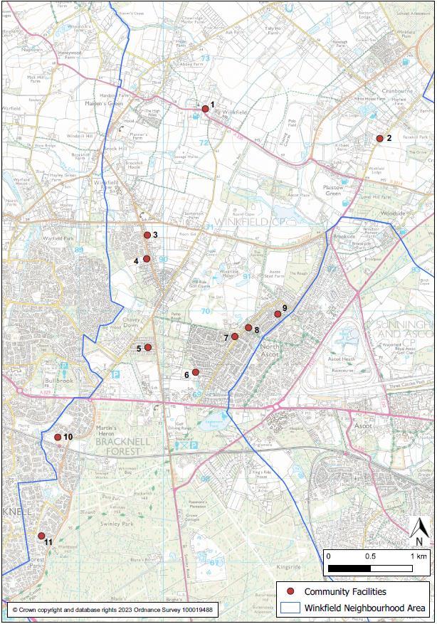
1. St Popel’s Hall, St Mary’s Church, Winkfield, SL4 4SE.
2. St Peter’s Church Hall, Cranbourne, SL4 2EG.
3. Charlotte Pratt Memorial Hall, Winkfield Row, RG42 7NY.
4. Carnation Hall, Winkfield Row, RG42 7PA.
5. St Martins Church Hall, Chavey Down, SL5 8RR.
6. Ascot Jubilee Pavilion, Goaters Road, North Ascot, SL5 8JA.
7. The Ark Youth Club (Trax Building), North Ascot, SL5 8JW.
8. The North Ascot Community Centre, SL5 8LA.
9. King Edwards Hall, North Ascot, SL5 8PD.
10. Martins Heron & The Warren Community Centre [MHWCA], RG12 9TZ.
11. Forest Park Community Centre, Forest Park, RG12 0XQ.
WINKFIELD PARISH NEIGHBOURHOOD PLAN: REFERENDUM VERSION November 2023 53
Figure 9.1: Community buildings in Winkfield, January 2022
10 Employment
Policy W7: Employment
A. Development proposals for new small-scale employment, including flexible startup/small scale accommodation, will be supported within settlements provided they:
i. do not adversely impact on neighbouring residential properties by noise, odour, dust, vibration or vehicle emissions,
ii. do not have an adverse effect on the existing transport network due to the requirement for significant commercial vehicle movements on inadequate rural routes.
B. Proposals to enable working from home which require planning permission will be supported, provided the business use remains ancillary to the main residential use and there is no significant harm caused to local residential amenity by way of car parking, traffic movements or noise.
C. Proposals which would have an unacceptable impact on the capacity or safety of the local highway network will not be supported.
10.1 In the Winkfield Neighbourhood Area there are two designated local shopping centres, at Forest Park and Martins Heron. The Martins Heron centre consists principally of a Tesco superstore, the Forest Park centre consists of a limited number of smaller stores. There are other small parades of shops in the Parish, including at Warren Row and Fernbank Road. Evidence gathered on key commercial facilities to inform the WNDP identified that most parts of the Parish are within two miles of a pharmacy, newsagent/general store and a post office, albeit many of these shops are outside the Parish. Proposals for any new retail units will be assessed against national and local planning policies.
10.2 There are no designated employment areas within the Parish. Commercial employment is therefore limited, with most opportunities located in Bracknell and to a lesser degree in Crowthorne and Sandhurst. The future need for employment space is difficult to forecast, not least because of the potential long-term impact of Covid on the way we work. However, opportunities to provide small scale, flexible workspace within the Parish should be encouraged. More people are likely to be working flexibly in future, both in the way that larger companies work in more disaggregated workplaces and with the possible growth of micro-businesses and start-ups taking advantage of new opportunities. Both will be looking for such opportunities which often are not provided on large business parks. For the purpose of Policy W7 a smallscale business use is an activity where the space could reasonably be used to operate a business employing 10 people or less.
WINKFIELD PARISH NEIGHBOURHOOD
REFERENDUM VERSION November 2023 54
PLAN:
10.3 Alongside 10.2, there has been increased office working from home.
10.4 Policy W7 therefore seeks to provide a local perspective to employment provision within the area, for small scale office/commercial space. The intention of such small scale provision would be to provide local employment opportunities and support the local community.
10.5 This policy also updates the support for home working, should proposals require planning permission. The policy is more permissive of such proposals, provided the business operations do not form the main use of the dwelling and its curtilage and are suited to a residential area and its amenities.
10.6 Development proposals arising from this policy are required to mitigate effects on the integrity of the Thames Basin Heath Special Protection Area in agreement with Bracknell Forest Council and Natural England. Measures may include a requirement to ensure that proposals resulting in a net increase car parking related to employment and retail development within 400m of the Thames Basin Heaths Special Protection Area cannot be made available to the general public wishing to access the SPA.
Delivers Plan Objectives: E, G and H
WINKFIELD PARISH NEIGHBOURHOOD PLAN: REFERENDUM VERSION November 2023 55
11 Green Infrastructure/Environment
Policy W8: Biodiversity and Wildlife Corridors
A. As appropriate to their scale, nature and location development proposals are expected to deliver at least a 10% biodiversity net gain in addition to protecting existing habitats and species. Development proposals on or adjacent to the wildlife corridors identified in Figure 11.1 and on the Policy Map must demonstrate a layout and design which ensures that wildlife is not impeded in its movement along the corridor. Proposals to enhance the wildlife corridors or create new corridors are strongly encouraged.
B. The incorporation of design features into development proposals that encourage and promote local wildlife will be particularly supported.
C. As part of its requirements to demonstrate biodiversity net gain, development should be designed to retain trees, shrubs and hedgerows of arboricultural, habitat and amenity value on-site and to conserve and enhance connectivity to the wider green and blue infrastructure networks. New planting should consist of native species of trees, shrubs and grasses acting and designed to provide accessibility for wildlife.
D. Where practicable development proposals should incorporate sustainable urban drainage and natural flood management techniques.
11.1 Biodiversity net gain is an approach to development that leaves biodiversity in a better state than it was before. It is also an approach where developers work with local governments, wildlife groups, land owners and other stakeholders in order to support their priorities for nature conservation. Development can generate opportunities to help achieve an overall benefit for biodiversity. Realising these opportunities is vital because biodiversity, and the functions it provides, are essential to sustain our society and economy.
11.2 Biodiversity net gain is mandated for developments requiring planning permission. In the planning system this is based on assessing land use and habitats for their ecological value before and after a planned development. By taking account of the type, size, location and condition of a habitat pre and post development, the metric uses biodiversity units to calculate the measurable improvement to habitats after development. Delivery of net gain should follow the sequential steps of the mitigation hierarchy: avoid impacts to biodiversity, mitigate impacts and finally compensate impacts. In addition, delivery of net gain should aim to be within the footprint of a development first or where this is not possible delivered at a suitable alternative site.
WINKFIELD PARISH NEIGHBOURHOOD PLAN: REFERENDUM VERSION November 2023 56
11.1 The WNDP Green Infrastructure Report confirms that the Parish has a wealth of green infrastructure assets. Green infrastructure is defined as a ‘network of multi-functional green space, urban and rural, which is capable of delivering a wide range of environmental and quality of life benefits for local communities. It includes parks, open spaces, playing fields, woodlands, but also street trees, hedgerows, allotments, and private gardens. It can also include streams and other water bodies and in urban areas, features such as green roofs and walls.’
11.2 The GI Report identifies a wildlife corridor east of Brock Hill Bridge (Bracknell Road) that follows The Cut through the Paddock north of Lambrook School Playing Fields passing Brock Hill House east of Winkfield Row B3017. The wildlife corridor continues east to Braziers Lane at Cooper’s Bridge, then south eastwards to Forest Road B3034. This wildlife corridor plays a key role in the protection of wildlife and biodiversity, and Policy W8 therefore protects it and encourages its enhancement. Its route is shown in Figure 11.1.
WINKFIELD PARISH NEIGHBOURHOOD
REFERENDUM VERSION November 2023 57
PLAN:
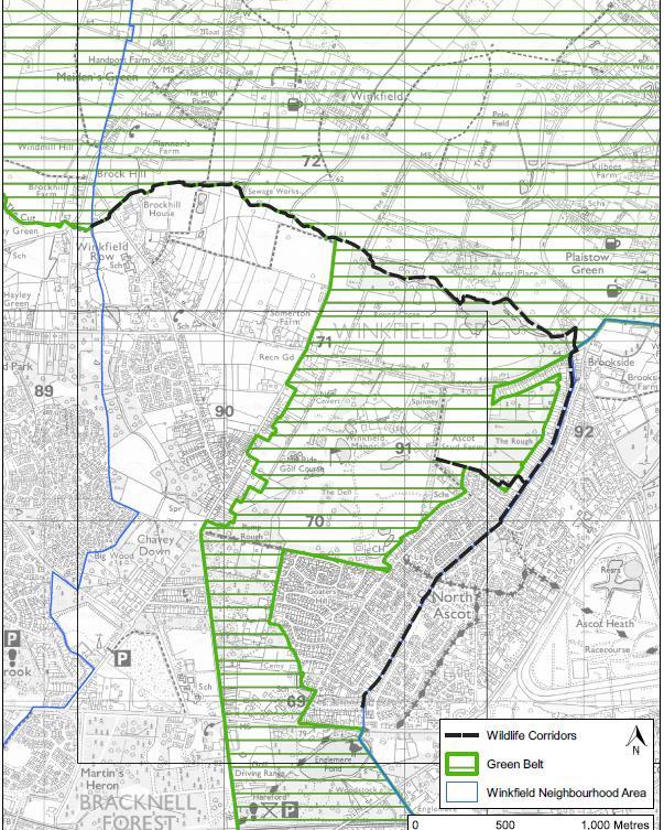
WINKFIELD PARISH NEIGHBOURHOOD
VERSION November 2023 58
PLAN: REFERENDUM
Figure 11.1: Wildlife Corridor Through Winkfield
11.3 The Bracknell Forest Green Infrastructure Review 2017 has also illustrated the significant ecological networks that exist in the Parish. The Parish has extensive areas of amenity green space and natural and semi-natural areas, particularly in the south and east of the Parish. It also has a series of blue infrastructure assets in the form of streams, ditches and other water courses. The networks are strong here which is why the creation of more wildlife corridors from the villages and neighbouring Bracknell and Ascot to these areas are so important for a range of species to thrive. Many areas are already protected by virtue of their status as Sites of Special Scientific Interest (SSSI), Special Areas of Conservation (SAC) or Local Wildlife Site (LWS). The policy seeks to ensure that these assets are more accessible to species for whom they are a natural habitat.
11.4 Where the protection and enhancement of green corridors can most easily be compromised is where development is poorly designed with little thought for wildlife movement. The design of individual buildings and of neighbourhood scale green and open spaces, including private gardens, will help to ensure that the species present in Winkfield can thrive. This is in line with the national planning guidance for achieving biodiversity net gain through all new development. Examples of the simple solutions that well-thought-out design can easily incorporate are:
• Integral bird and bat boxes under the eaves of the new houses, or artificial nests sited in places away from windows and doors can create vital new roosting sites to support populations of birds and bats.
• Boundaries between dwellings can be made hedgehog friendly by including pre-cut holes for hedgehogs to more effectively move across neighbourhoods to forage.
• New planting schemes can support bees and other pollinators by including nectar-rich plants.
Delivers Plan Objectives: D and F
WINKFIELD PARISH NEIGHBOURHOOD PLAN: REFERENDUM VERSION November 2023 59
Policy W9: The Winkfield Row North/Winkfield Row South Local Gap
A. Development proposals should maintain the integrity of the Winkfield Row North/Winkfield Row South Local Gap as shown on the Policies Map. Proposals that would have an unacceptable impact on the integrity of the Local Gap, either physically or visually, will not be supported.
11.5 The villages and hamlets lying between Bracknell and Warfield and North Ascot are where development pressures are at their greatest. The villages are separated by relatively narrow and diminishing areas of countryside as Bracknell and its own villages and hamlets continue to grow.
11.6 There is one area between settlements which is not protected but could result in coalescence of the settlements. This is the area between Winkfield Row North and Winkfield Row South, as shown in Figure 11.2. The area includes King George V playing fields and St Marys School and the land between Lambrook School and Forest Road (B3034).
11.7 This is important because such gaps provide a valuable source of green infrastructure which may offer important recreational, health and landscape benefits to the local community as well as nature conservation value. Once these gaps are lost, the impacts on wildlife movement can be considerable. In maintaining the visual integrity of the gap, development proposals must demonstrate how the landscape character has been taken into consideration and that valued landscape functions relating to the separation of settlements will not be compromised, on a cumulative or individual basis. Proposals in the local gap will be required to demonstrate how they might reinforce the positive characteristics of the gap.
WINKFIELD PARISH NEIGHBOURHOOD PLAN: REFERENDUM VERSION November 2023 60
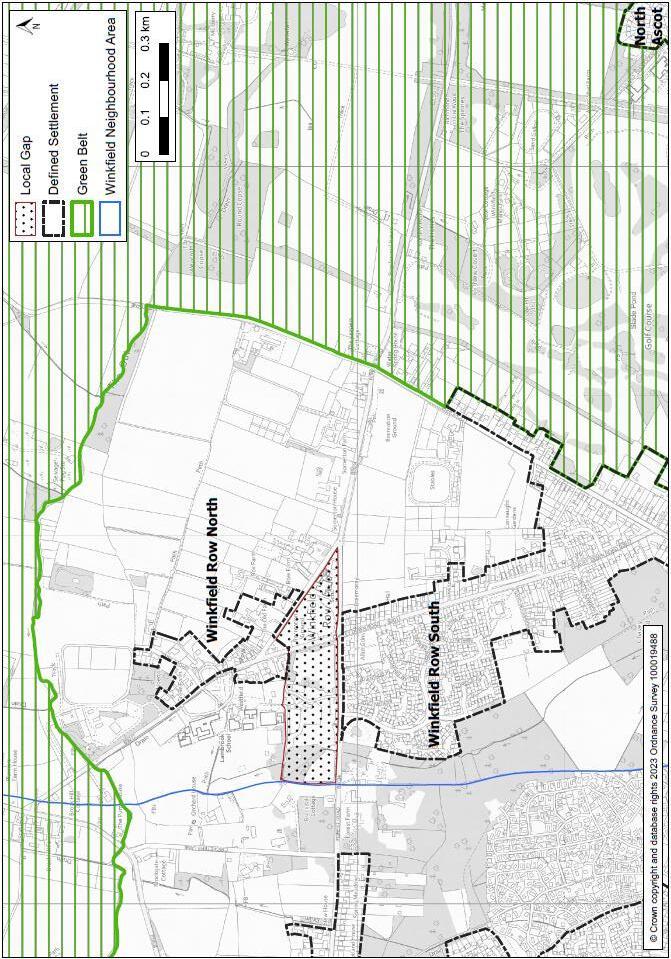
WINKFIELD PARISH NEIGHBOURHOOD
REFERENDUM VERSION November 2023 61
PLAN:
Figure 11.2: Winkfield Row North – Winkfield Row South Local Gap
11.8 As stated in paragraphs 6.7 – 6.8 of this Plan, the designation of a gap including a local gap - will not prevent development. Rather, development proposals will need to demonstrate that the landscape functions relating to the separation of settlements have not been compromised, including on a cumulative basis (as a result of a number of recent developments or proposals). This will be considered in accordance with the Bracknell Forest Landscape Character Assessment (LCA) 2015 and the Recommendations Report (2015). These reports show that the Local Gap is located within the Chavey Down Wooded Sands (F1) Character Area. Valued features and characteristics of the area as identified in the report are:
• the continuous network of woodland,
• naturalistic land cover,
• areas of natural, undeveloped character,
• the presence of ponds,
• remnant pastoral fields divided by hedgerows with hedgerow trees,
• views across small clearings, paddocks, and pastures,
• the long straight roads following the route of rides through the former Historic Royal Forest of Windsor; and
• footpaths and areas of public access.
Delivers Plan Objectives: A and B
WINKFIELD PARISH NEIGHBOURHOOD
REFERENDUM VERSION November 2023 62
PLAN:
Policy W10: Dark Skies
While ensuring new developments are secure in terms of occupier and vehicle safety, outdoor lighting systems should be designed to limit their impact on the environment, including light pollution and its associated effects on wildlife. Wherever practicable, low energy lighting technologies should be used to reduce consumption and minimise glare in order to keep night-time skies dark.
11.9 This policy reflects paragraph 185 of the NPPF. This states that planning policies and decisions should ensure that new development is appropriate for its location taking into account the likely effects (including cumulative effects) of pollution on health, living conditions and the natural environment, as well as the potential sensitivity of the site or the wider area to potential impacts of the development. It continues by stating that this could include limiting the impact of light pollution from artificial light on local amenity, intrinsically dark landscapes, and nature conservation.
11.10Light pollution is the light that is wasted upwards and outwards beyond a development’s boundary. Upward light reflects off the atmosphere, causing the visible blanket cover in the sky above towns and rural areas at night. Obtrusive light is generally a consequence of poorly designed insensitive lighting schemes, resulting in sky glow, glare, and light trespass, where light spills beyond the boundary of a property on which the lighting is located.
11.11External lighting design should be considered at a development’s planning stage. Poorly conceived lighting designs can be difficult to rectify and so it is important to ensure that the lighting design is appropriate from the outset. Artificial light is not always appropriate or necessary and has the potential to cause light pollution. It can be a source of annoyance to people, harmful to wildlife, undermine enjoyment of the countryside and detract from enjoyment of the night sky.
11.12External lighting designs shall consider the use of full cut off luminaires or similar, with lights positioned to illuminate inwards from a development’s boundary, as opposed to outwards from a wall mounted light on a building. External lighting circuits should incorporate automatic time switching, PIRs or similar to avoid lighting being on when not required. External lighting designs shall comply with guidance and recommendations issued by the Institution of Lighting Professionals.
Delivers Plan Objectives: A and F
WINKFIELD PARISH NEIGHBOURHOOD PLAN: REFERENDUM VERSION November 2023 63
Policy W11: Local Green Spaces
A. The following spaces as shown on the Policy Map are designated as Local Green Spaces:
1. Allsmoor Field, Martins Heron
2. Blackmoor Close Play Space
3. Bog Lane, The Warren
4. Fernbank Road Play Area
5. King George V Recreation Ground
6. Land off Bruton Way, Forest Park
7. Locks Ride Recreation Ground
8. Longhill Park
9. Osmans Close Woodland
10. Savernake Park
11. Winkfield Row Allotments
12. World’s End, Pyegrove Chase
B. Proposals for built development on this Local Green Space will only be permitted in very special circumstances.
11.13Under the National Planning Policy Framework (NPPF) 2021 the WNDP can identify and protect green areas which are of particular importance to the local community. This will afford protection from development other than in very special circumstances.
11.14The Local Green Space designation should only be used where the green space is:
a. in reasonably close proximity to the community it serves,
b. demonstrably special to a local community and of a particular local significance, for example because of its beauty, historic significance, recreational value (including as a playing field), tranquillity or richness of its wildlife; and
c. local in character and not an extensive tract of land.
11.15The areas identified in Policy W11 have been identified by the community as being of value and fulfil all the criteria of the NPPF for designation as Local Green Spaces.
WINKFIELD PARISH NEIGHBOURHOOD
REFERENDUM VERSION November 2023 64
PLAN:
11.16The designated Local Green Spaces are shown on Figure 11.3. Detailed maps of each Local Green Space are shown in Appendix A.
WINKFIELD
NEIGHBOURHOOD
November 2023 65
PARISH
PLAN: REFERENDUM VERSION
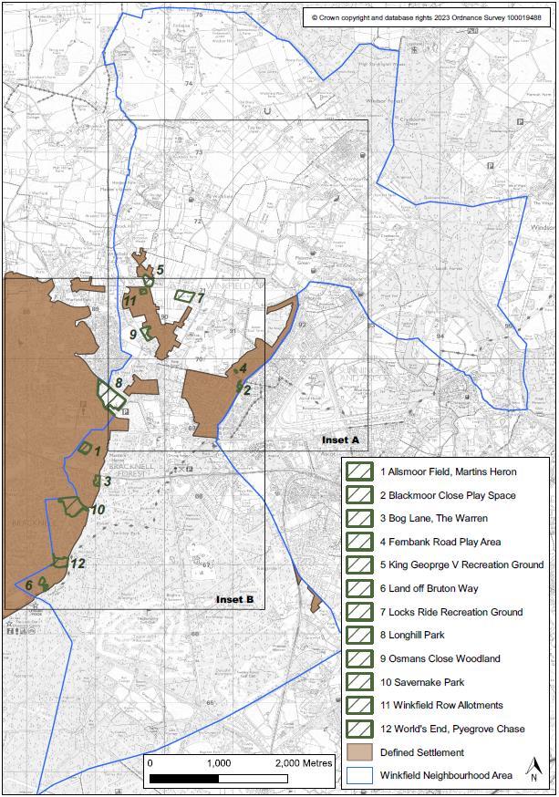
WINKFIELD PARISH NEIGHBOURHOOD
November 2023 66
PLAN: REFERENDUM VERSION
Figure 11.3: Local Green Spaces
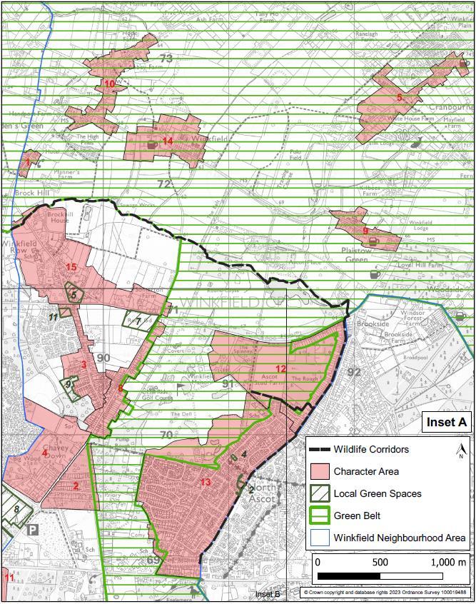
WINKFIELD PARISH NEIGHBOURHOOD
November 2023 67
PLAN: REFERENDUM VERSION
Figure 11.4: Local Green Spaces – Inset A
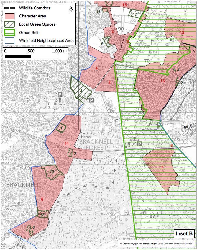
WINKFIELD
November 2023 68
PARISH NEIGHBOURHOOD PLAN: REFERENDUM VERSION
Figure 11.5: Local Green Spaces – Inset B
Allsmoor Field (1.82 hectares) is a large area of public open space in the heart of Martins Heron housing estate.
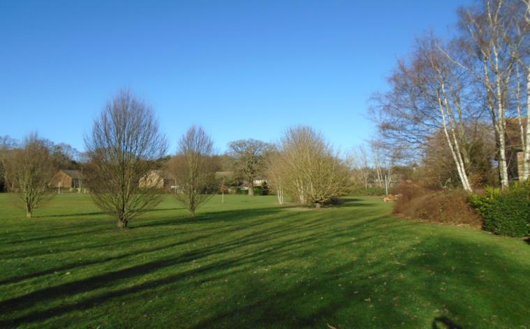
The site has a good selection of deciduous and coniferous trees on two sides of the field, with oak, sweet chestnut, horse chestnut and holly providing habitats for animals and a wide selection of birds, including over-wintering blackcaps, green and lesser-spotted woodpeckers and sparrow hawk.
It provides a valued open space for informal community recreation activities such as walking, cycling, dog walking and informal play. The area is used by local residents of all ages from children using the play area to adults walking the perimeter for exercise.
In addition to the enclosed play area there is an outdoor gym, picnic benches and other seating plus a combination goal area.
In 2022 seventy cherry blossom trees were planted creating a tree avenue to mark the Queen’s 70th Jubilee.
This site has a Green Flag Award which is the benchmark standard for the management of recreational outdoor spaces across the United Kingdom and around the world.
WINKFIELD PARISH NEIGHBOURHOOD PLAN: REFERENDUM VERSION November 2023 69
1. Allsmoor Field, Martins Heron
2.
This small green open space (0.1ha) in the middle of North Ascot has an open children’s play area together with benches and waste bins. It is also used as a pedestrian walkway between roads in the locale. Although a small green space, it is especially valued by local residents to meet up and for local families to meet whilst children play safely.
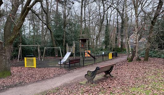
Bog Lane in The Warren (1.72ha) provides a valued open space for informal community recreation activities such as walking, cycling, dog walking, community events and informal play.
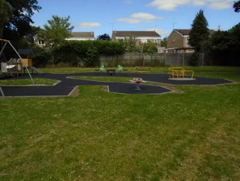
It is a quiet, sheltered space providing a protected habitat for a range of animals and wildlife.
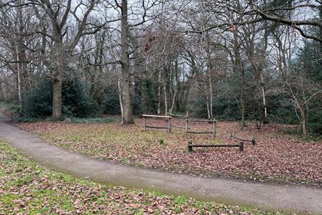
WINKFIELD
NEIGHBOURHOOD
November 2023 70
PARISH
PLAN: REFERENDUM VERSION
Blackmoor Close Play Space
3. Bog Lane, The Warren
4. Fernbank Road Play Area
Fernbank Road play area is a small area of public open space (0.16ha) in the middle of North Ascot housing. The site has an open children’s play area together with benches and waste bins. Situated behind the local community centre, library and nursery school and close to local infant and junior schools, it is well used by families and their children as a green space close to where they live.
This large expanse of public open space is adjacent to St Mary’s Church of England Primary School. There is a large car park and a number of pedestrian entrances around the site. This site has a Green Flag Award which is the benchmark standard for the management of recreational outdoor spaces across the United Kingdom and around the world.
The site has an open children’s play area and there are also picnic benches, BBQs available to rent for small gatherings, and numerous benches and waste bins around the site. The Junior football pitches are used by the school for 7 a-side matches.
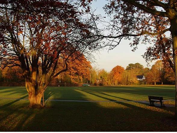
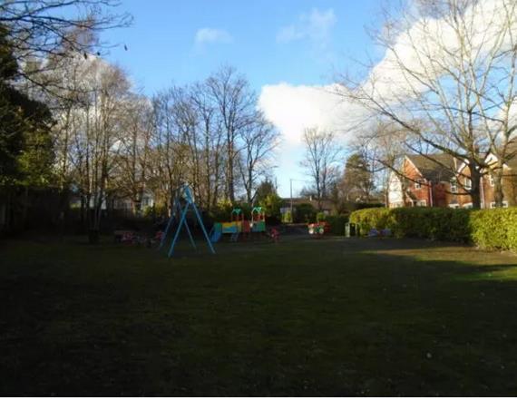
WINKFIELD PARISH NEIGHBOURHOOD
November 2023 71
PLAN: REFERENDUM VERSION
5. King George V Recreation Ground
6. Land off Bruton Way, Forest Park
This area, in the middle of the estate (0.92ha), provides the community with an open green space with mature trees and is used by families and dog walkers. There is a wide range of flowering/fruit bushes - rosehip, rhododendrons, blackberries and cherry plants as well as deciduous and coniferous trees. This provides habitat for animals and particularly birds such as magpies, jays, blackbirds, kites and woodpeckers. The green space is separated by public footpaths linking them to the main roads through the far end of Forest Park and has a high brick wall separating the open area from the main road and the entrances to Swinley Forest.
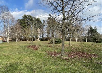
7. Locks Ride Recreation Ground
Locks Ride Recreation Ground (3.29ha) provides a valued open space for informal community recreation activities such as walking, cycling, community events and informal play. It is a site of sport, recreation and has amenity value through the provision of space for formal sporting and community recreational activities.
The site has a large open children’s beach themed play area together with a water splash area and a selection of outdoor gym equipment.
There is also a refreshment unit on-site, Locks Ride Cabin, which opens daily throughout the summer months (and periodically through the winter months) serving hot and cold drinks, snacks and ice-cream. There are large and small BBQs available to rent for small gatherings.
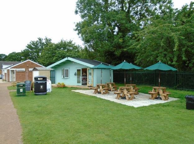
Locks Ride incorporates a small sports pavilion which is used by resident football and cricket teams year-round. This site has a Green Flag Award which is the benchmark
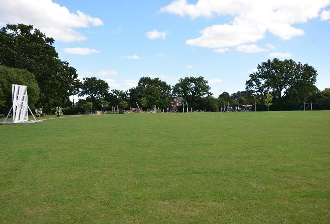
WINKFIELD PARISH NEIGHBOURHOOD PLAN: REFERENDUM VERSION November 2023 72
standard for the management of recreational outdoor spaces across the United Kingdom and around the world, in recognition of the well-maintained green space.
8. Longhill Park
Longhill Park in Chavey Down (9.3ha), is a designated Suitable Alternative Natural Green Space (SANG) and a designated wildlife heritage site because of its valuable plants and animals.
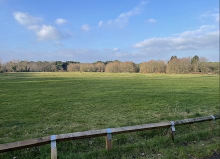
Longhill Park was formerly a refuse site that has since been reclaimed for wildlife and public recreation purposes. Today, the site is popular for walking, particularly dog walkers with families and children. It is now a 24-acre site of hay meadow, woodland and playground.
The meadow area holds a mixture of wildflowers such as knapweed, ox-eye daisy, lady's smock, southern marsh orchid and is also home to common blue and small copper butterflies.
Typical mixed woodland borders the meadow area with the rides notably containing broad-leaved helleborine. Sparrowhawks, goldcrest, wintering thrushes, summer warblers and bullfinch (a Bracknell Biodiversity Action Plan Species) are to be found within the site as well as a translocated population of slow worms. There is a notable and active badger set under the nearby scrub.
The site is generally flat and reasonably accessible for the mobility-impaired and cycling is permitted along the track to the south west of the site.
In addition to the junior and toddler park play area, Longhill Park has the largest BMX skate park in Bracknell Forest and provides a unique recreational resource to the younger residents of Winkfield Parish.
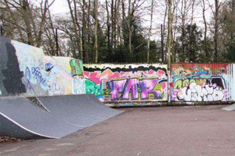
WINKFIELD PARISH NEIGHBOURHOOD PLAN: REFERENDUM VERSION November 2023 73
9. Osmans Close Woodland
Osmans Close Woodland (1.65 ha) off Osmans Close, is a significant area of wildlife value.
This area of ancient woodland is one of the 'Three Copses' (along with Piggy Wood and Whitegrove Copse that totals 7.8 ha) that forming an important nature reserve and wildlife corridor. Bluebells and other wild flowers appear in spring along with both native and migrant birds including blue tits, coal tits, chiffchaffs and green woodpeckers.
Osmans Close is well-used by the local communities of Chavey Down and Winkfield Row providing an area to walk in ancient woodland. It is especially well used by dog walkers and ramblers and can provide the local schools with an area suitable for forest schooling.
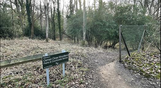
Osmans Close provides the community with access to a range of biodiversity-rich areas and should be protected for the enjoyment of the community and also in order to safeguard and enhance their biodiversity.
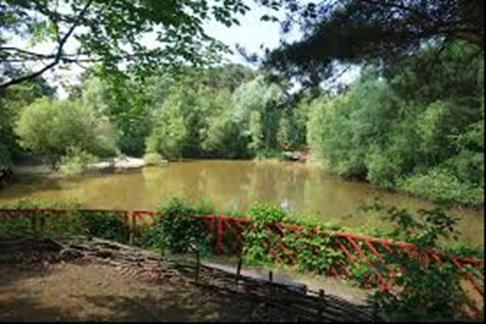
Savernake Park (6.5ha) provides open space valued for informal community recreation activities such as walking, cycling, dog walking, community events and informal play. It is likely that the site used to be part of the Great Windsor Forest, a vast expanse of royal hunting forest going back to the times of the Doomsday Book. In the 1990s, Savernake Park was adopted by Bracknell Forest Council who now manages the site for recreation and wildlife.
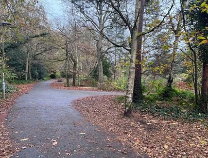
WINKFIELD PARISH NEIGHBOURHOOD PLAN: REFERENDUM VERSION November 2023 74
10. Savernake Park
The features below are extensively used by the residents of all ages and contribute to the value of this park situated between Forest Park and Martins Heron and the Warren:
• wildlife, such as noctule bats can be found in the woodland east of the site and is designated a Local Wildlife Site,
• surfaced paths and gentle slopes enabling wheelchair access,
• surfaced paths and a shared footpath/cycleway linking it with Allsmoor Lane and beyond,
• a popular play area available for children and a large grassed area for picnicking and ball games,
• newly planted heathland areas providing new wildlife habitat,
• a balancing pond, owned and managed by Thames Water, which takes excess water during times of heavy rainfall. This pond contains a good stock of fish and is home to an assortment of waterfowl including ducks, geese and moorhens.
11. Winkfield Row Allotments
Winkfield Row allotment (0.57ha) is one of two important sites of recreation and amenity value to local residents, providing space for growing fruit and vegetables and for local wildlife to thrive. It comprises 10 full plots and 56 half-plots with four stand pipes to provide water for the gardeners. There is strong local demand for allotments with a waiting list for people to be able to rent a plot.
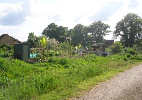
WINKFIELD
November 2023 75
PARISH NEIGHBOURHOOD PLAN: REFERENDUM VERSION
World’s End, in Pyegrove Chase (3.74ha), provides open space valued for informal community recreation activities such as walking, cycling, dog walking, community events and informal play. World’s End also provides amenities such as basketball, goalposts and a toddler area with swings. The site has a good selection of trees providing habitats for animals and a wide selection of birds including a pair of nesting kites, green and lesser-spotted woodpeckers and sparrow hawks.
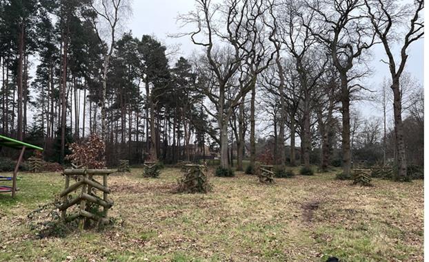
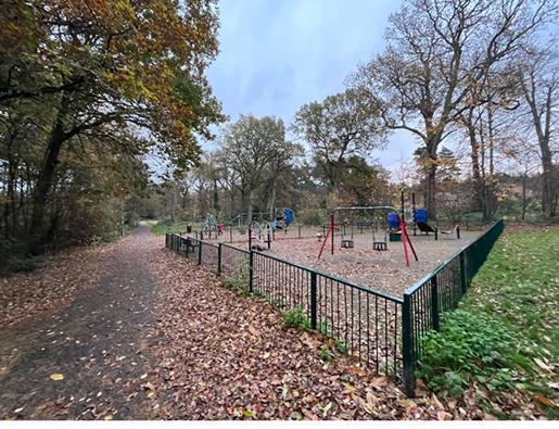
It is a very popular open space with all facilities used most days and throughout the day.
As it is on the main cycleway and thoroughfare out to The Look Out and Coral Reef plus a link between Crown Wood and Forest Park, many families use the park and picnic benches now incorporated into the play area.
The area of World’s End that is enjoyed by the community extends outside the Parish. However, the WNDP can only designate the part that is within the Parish boundary.
WINKFIELD
November 2023 76
PARISH NEIGHBOURHOOD PLAN: REFERENDUM VERSION
12. World’s End, Pyegrove Chase
The following areas were reviewed for inclusion as designated Green Spaces but were excluded as they are already within the Green Belt:
a. Cranbourne Allotments
b. Asher Recreation Ground, Lovel Road Cranbourne
c. Ascot Jubilee Recreation Ground, Goaters Road, North Ascot
d. Priory Road Cemetery (located between Priory Road and Ascot Jubilee Recreation Ground)
e. Tow's Bourne Pond, Winkfield Lane, Maidens Green
f. Wentworth Way Woodland, North Ascot
g. Old Moat in Winkfield Lane, Maidens Green
h. Sandy Lane, located between Chavey Down and North Ascot
i. Ancient Hedgerow Gap in Winkfield Street
j. Englemere Pond. SANGS. Significant area of wildlife value.
k. Swinley Park is a large green area (431.9 hectares) which provides open space value for informal community recreation activities and is a significant area of wildlife value. Swinley Forest is owned and managed by the Crown Estate and is not nominated as a Local Green Space due to it being an extensive tract of land.
Delivering Plan Objectives: D and F
WINKFIELD
November 2023 77
PARISH NEIGHBOURHOOD PLAN: REFERENDUM VERSION
12 Promoting Sustainable Transport
Policy W12: Pedestrian/Cycle Network
A. Development which provides new transport infrastructure or improves existing transport infrastructure should be designed to maximise use by pedestrians, mobility impaired users and cyclists. Such infrastructure comprises footways, footpaths/public rights of way, bridleways and cycleways.
B. Specific proposals to improve pedestrian and cycle access will be supported. Such proposals should focus on improving access between residential areas and important local facilities, including schools, railway stations and public transport nodes, community facilities, important employment areas and the neighbouring main centres of Bracknell, Windsor and Ascot.
C. As appropriate to their scale, nature and location, development proposals should seek to ensure that they incorporate safe access points to link up with existing footways and cycle routes wherever practicable.
WINKFIELD PARISH NEIGHBOURHOOD
REFERENDUM VERSION November 2023 78
PLAN:
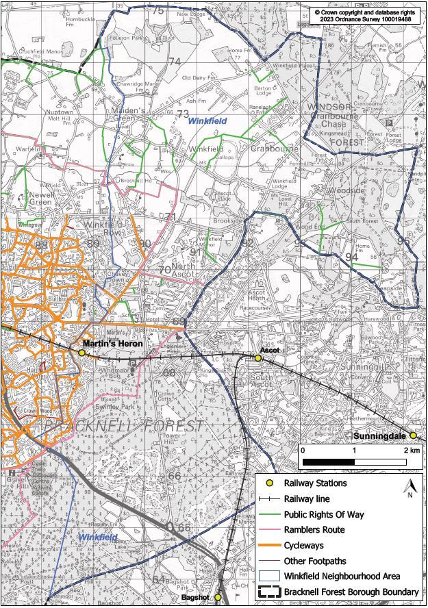
WINKFIELD
NEIGHBOURHOOD
November 2023 79
PARISH
PLAN: REFERENDUM VERSION
Figure 12.1: Sustainable Travel in And Close to Winkfield Parish
12.1 Transport in Winkfield Parish is a mixture of very busy major transport corridors, urban highways, main roads, rural roads, and relatively quiet countryside roads. There is one railway line running east to west through the centre of the Parish but there is poor coverage of bus routes within the Parish. Congestion, especially at peak hours, is recognised at many road junctions including:
• The newly constructed A329 junctions with New Forest Ride (Mercedes Garage),
• Priory Road (The Royal Foresters pub) and,
• Fernbank Road (LVS School).
12.2 The junction of the A322 and the A332 (Swinley Road Gyratory) and on towards the M3, Junction 3. These are the main areas of concern but there is also congestion at many minor routes throughout the Parish
12.3 In a five-year period (2016 to 2020) over 158 collisions occurred within the Parish. Approximately 17 were classed as serious and there were six fatalities. The A329 has the worst accident record within the Parish, with its junctions with New Forest Ride, Priory Road and Fernbank Road being where most accidents occur. There were 15 recorded collisions on the A329 between the east and west Parish boundaries, two of them serious. In the same period there have been approximately 23 traffic accidents involving cyclists on the roads in the Parish, one of them serious and one fatal. Seven motorcyclists were injured, four of them seriously and four pedestrians were also injured in traffic collisions. It should be noted that these figures are only the reported incidents where people were injured. There are many more non-injury minor incidents which go unreported.
12.4 There is therefore a common concern across the Parish of road safety and parking. There is also concern that future growth could exacerbate these issues. This requires a solution to traffic which will result from additional use and efforts are needed to encourage travel by means other than the car. Therefore, there is a requirement for good and safe routes for pedestrians and cyclists, especially for children walking to school.
12.5 There are several cycle paths and leisure cycle ways in the Parish. In the builtup areas they are often joint pedestrian/cycle paths, generally around the centre of the Parish such as along the A329 Bracknell to Ascot Road and radiating from this north and south into populated/shopping areas. The main cycleway connects Bracknell to Ascot racecourse (Figure 12.1).
12.6 A key requirement of cycle paths is continuity; within the confines of central Bracknell, it is possible to cycle off-road across most of the area but venturing out into northern Winkfield means cycling on often narrow major roads with the consequent increase in traffic speeds and thus danger levels. This makes safe cycling difficult, especially around schools.
WINKFIELD PARISH NEIGHBOURHOOD
VERSION November 2023 80
PLAN: REFERENDUM
12.7 A new network of safe, dedicated and convenient pedestrian and cycle routes would enable people to walk or cycle more often for their daily journeys to school, work and trips to local services. These routes should link up both the Parish settlements and wider afield to the nearby towns of Bracknell, Windsor, Maidenhead and Ascot. Part C of Policy W12 addresses this matter. To help ensure that residents can walk and cycle safely to local facilities serving the community, development proposals should seek to ensure safe access to link up with existing footways and cycle routes, wherever practicable. This is particularly important where existing access is limited but is capable of improvement.
12.8 Although there are footpaths linking different estates in the centre of the Parish, footpaths and byways outside of this tend to be for recreational use only. Pavements are rarely continuous, and pedestrians frequently have to walk in and across the road. This deters people from walking safely. Pathways trodden into the grass demonstrate the need for additional pathways as pedestrians seek the easiest route to their destination. In addition, where roads are narrow, cars are often parked with two wheels on the pavement reducing the available width for pedestrians, pushchairs, and wheelchairs, sometimes blocking it altogether. Forest Park, Martins Heron and The Warren in particular are affected by these problems. Many residents (46% of questionnaire respondents) have expressed concern over inconsiderate parking. The B3022 at Brock Hill and at Cranbourne which carries a lot of traffic in peak hours is also affected in this way with cars parking on both sides of the road making pedestrian movement difficult, as are North Road and Church Road in Chavey Down.
12.9 The policy therefore seeks to address these issues. Where improvements are needed, contributions will be sought through S106 agreements, subject to compliance with the Community Infrastructure Levy Regulations 2010 (as amended), or via planning conditions or CIL as appropriate and will be used to part-fund these and lever in match funding from other sources where possible.
Delivering Plan Objectives: G and H
WINKFIELD PARISH NEIGHBOURHOOD PLAN: REFERENDUM VERSION November 2023 81
Policy W13: Martins Heron Station
A. Proposals to deliver improvements at Martins Heron Railway Station that will encourage access to and from the station for pedestrians and cyclists are supported. This includes but is not limited to:
a. an increase in the cycle racks and improvement of security,
b. the extension of existing bus routes to encompass Martins Heron Station and,
c. improvements to station access highway safety, especially for pedestrians and cyclists.
B. Proposals to provide more car and cycle parking at the Station will be supported.
C. Proposals that result in a reduction in the total amount of cycle racks and car parking spaces at the Station or will further harm the existing highways safety standards or accessibility for pedestrians and cyclists will not be supported.
12.10This policy recognises the importance of station improvements at Martins Heron Railway Station.
12.11Martins Heron Railway Station has proved to be popular with commuters510,588 passengers used the station in 2019-2020, which was down 7.9% on 2018-2019 because of Covid lockdown. It is considered that the promotion of free parking spaces at the station contributes to its popularity. Unfortunately, when the station was built there were less than 40 parking spaces available. This was reduced to 37 car parking spaces when a supermarket adjacent to the station enlarged its store and the delivery area. The lack of parking provision has resulted in many commuters parking in neighbouring residential roads.
12.12Due to increased passenger numbers, South Western Railway (SWR) has increased the length of most trains from 8 to 10 carriages and has completed lengthening platforms along the route, including at Martins Heron. This will almost certainly increase the number of commuters using the station and therefore cause even more parking problems. Royal Ascot Week adds to the commuter problem and makes the station exceedingly busy as many racegoers find it easier to park for free in the local area and travel the short distance of one stop to Ascot. It should also be noted that the entrance to Martins Heron Railway Station is also the access point for Tesco’s delivery lorries, often causing congestion and access problems. There are currently no bus routes that run to this station. It would be easy to extend the existing route 156 to encompass Martins Heron Railway Station. The policy tries to secure solutions to the issues identified through supporting station improvements that enable the provision of facilities required.
Delivering Plan Objective: G
WINKFIELD PARISH NEIGHBOURHOOD
VERSION November 2023 82
PLAN: REFERENDUM
13 Implementation
13.1 The WNDP will be implemented through a combination of the local planning authority’s consideration and determination of planning applications for development in the Parish, and through steering public and private investment into a series of infrastructure proposals contained in the plan.
Development Management
13.2 Most of the policies contained in the WNDP will be delivered by landowners and developers. In preparing the WNDP, care has been taken to ensure, as a possible, that the policies are achievable.
13.3 13.3 Whilst the local planning authority will be responsible for the development management, the Parish Council will use the WNDP to frame its representations on submitted planning applications. It will also work with BFC to monitor the progress of sites coming forward for development and ensure that developers embrace Environmental, Social and Governance (ESG) for the long-term sustainable benefit of our community.
Infrastructure Projects
13.4 The following have been identified by the WNDP Steering Group as possible projects that could benefit from investment of future Community Infrastructure Levy (CIL) funding allocated by the local planning authority to the Parish Council:
1. Youth Hub
2. Cycle ways, allotments, drainage
3. Proposed cycleway routes identified in Supplement B: Proposed Cycle Routes through Winkfield Parish (wnspg_green_infra_cycle_route_proposals and Policy W11)
4. Additional allotments described in Supplement A: Assessment of Local Green Space in Winkfield Parish (Supplement A - wnspg_green_infra_assessment_local_green_space)
5. Drainage for Asher Recreation Ground described in Section 4.4 of Supplement A – this was completed in 2021 : Assessment of Local Green Space in Winkfield Parish
Traffic, junction, and bus improvements
6. Traffic calming at the following locations:
a. Forest Road, Chavey Down Road, Harvest Ride, Winkfield Lane, Windsor Road, Hatchet Lane, Lovel Road, Locks Ride, Brock Hill, Maidens Green Crossroads, Braziers Lane, North Street, Church Road, New Road, Fernbank Road, London Road, Bagshot Road,
WINKFIELD PARISH NEIGHBOURHOOD PLAN: REFERENDUM VERSION November 2023 83
Swinley Road, Ascot Road, Priory Road, Long Hill Road, New Forest Ride, near schools
7. Junction Improvements at the following locations:
a. Forest Road/Braziers Lane/Church Road, Braziers Lane/Forest Road/Locks Ride, North Street/Crouch Lane, Chavey Down Road/Locks Ride, Fernbank Road/New Road
b. Chavey Down Road/Forest Road, London Road/Long Hill Road, Woodside Road, Forest Road, Priory Road/Locks Ride
c. Swinley Road/Kings Ride, New Road/Forest Road, New Road/Beechwood Close, London Road/Priory Road
8. Bus improvements.
9. Ascot Heath Library: As described in the Community Facilities Evidence document page 24
10. Safe Routes to school – The Parish Council together with Bracknell Forest Council will develop traffic management measures which promote pedestrian safety and improve sustainable transport such as enhanced footpaths, bridleways and cycle ways including speed reduction measures of 20mph zones, electronically timed to coincide with school opening hours, near schools.
13.5 This series of local infrastructure projects will be prioritised for investment from Section 106 agreements and, if implemented in the future, CIL. A minimum of 25% of the levy collected from development in the Parish will be passed to the Parish Council for investment in the Parish. This provides the local community with an indication of the priorities for investing the fund to improve local infrastructure as a result of new development in the Parish.
13.6 In addition, other policies of the WNDP require some planning obligations to be entered into as part of planning consents to finance and deliver specific infrastructure projects relating to the development scheme in order to make the scheme satisfactory in line with the NPPF.
WINKFIELD PARISH NEIGHBOURHOOD
November 2023 84
PLAN: REFERENDUM VERSION
Policy Maps
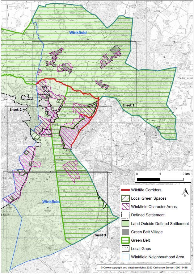
WINKFIELD PARISH NEIGHBOURHOOD
November 2023 85
PLAN: REFERENDUM VERSION
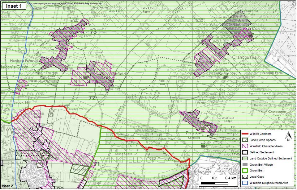
WINKFIELD PARISH NEIGHBOURHOOD PLAN: REFERENDUM VERSION November 2023 86
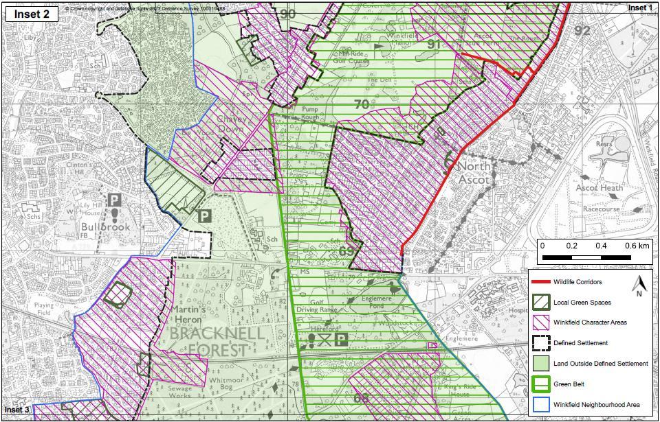
WINKFIELD PARISH NEIGHBOURHOOD PLAN: REFERENDUM VERSION November 2023 87
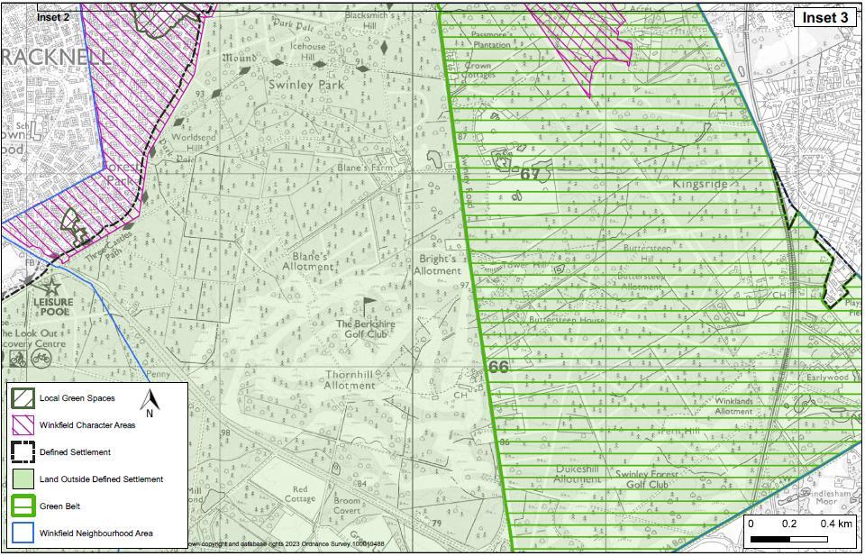
WINKFIELD PARISH NEIGHBOURHOOD PLAN: REFERENDUM VERSION November 2023 88
Glossary and Abbreviations
Affordable Housing Social rented, affordable rented and intermediate housing, provided to eligible households whose needs are not met by the market.
Amenity A positive element or elements that contribute to the overall character or enjoyment of an area. For example, open land, trees, historic buildings, and the inter-relationship between them, or less tangible factors such as tranquillity.
Amenity Green Space
Biodiversity
Open land, often landscaped, that makes a positive contribution to the appearance of an area or improves the quality of the lives of people living or working within the locality.
Biodiversity is the term used to describe the whole variety of life on Earth. It includes not only all species of plants and animals, but also the complex ecosystems they live within. It ranges from species and habitats which are considered commonplace to those considered critically endangered.
Blue Infrastructure Blue-green infrastructure refers to the use of blue elements, like rivers, canals, ponds, wetlands, floodplains, water treatment facilities, and green elements, such as trees, forests, fields and parks, in urban and land-use planning.
Bracknell Forest Council (BFC)
Brownfield Land and Sites (also see Previously Developed Land (PDL)
The principal planning authority for this Neighbourhood Plan.
Land which is or was occupied by a permanent structure, including the curtilage of the developed land and any associated fixed surface infrastructure (excludes mineral workings, agriculture and forestry buildings or other temporary structures, and land that was PDL Brownfield land but where the remains of permanent structures have blended into the landscape in the process of time). The definition does not include residential gardens, parks, recreation grounds or allotments. Also referred to as ‘previously developed’ land.
Community Infrastructure Levy (CIL)
A levy allowing local authorities to raise funds from owners or developers of land undertaking new building projects in their area.
Conservation Areas Areas designated by the Local Planning Authority under the Planning (Listed Buildings and Conservation Areas) Act 1990 Section 69 as being of special architectural or historic interest, the character of which it is desirable to preserve and enhance.
Core Strategy
A Development Plan Document setting out the spatial vision and strategic objectives of the planning framework for an area.
WINKFIELD PARISH NEIGHBOURHOOD PLAN: REFERENDUM VERSION November 2023 89
Countryside Land, which is outside the defined Green Belt, and outside of built-up areas (i.e., outside of defined settlement boundaries).
Dark Skies
These areas will be defined within a dark sky core boundary (to be shown on the policy map), which shows the darkest areas within our Parish. It also identifies areas most at threat from light pollution, known as “areas vulnerable to change” .
Density
In the case of residential development, a measurement of either the number of habitable rooms per hectare or the number of dwellings per hectare.
Development Development is defined under the 1990 Town and Country Planning Act as "the carrying out of building, engineering, mining, or other operation in, on, over or under land, or the making of any material change in the use of any building or other land."
Development Plan Documents (DPDs)
Development Plan Documents (DPDs) are prepared by local planning authorities and form an essential part of the Development Plan, outlining the key development goals. Once adopted, development control decisions must be made in accordance with them unless material considerations indicate otherwise.
Environmental, Social and Governance (ESG)
Evidence Base
Flood Zones
Environmental, Social, and Governance (ESG) criteria are a set of standards for a company’s operations that socially conscious investors use to screen potential investments. Environmental criteria consider how a company performs as a steward of nature.
The information and analysis that is the basis of evidence for the development of the NDP.
Flood Zones refer to the probability of river and sea flooding, ignoring the presence of defences. Flood Zone 1 is low probability; Flood Zone 2 is medium probability; Flood Zone 3a is high probability and Flood Zone 3b is functional flood plain where land must be stored or flows at time of flood.
Green Belt
A Green Belt is a policy and land use zone designation used in land use planning to retain areas of largely undeveloped, wild, or agricultural land surrounding or neighbouring urban areas. It is an invisible line designating a border around a certain area, preventing development of the area, and allowing wildlife to return and be established.
Green Infrastructure (GI)
Green Infrastructure is a network of multi-functional green space and other green features, urban and rural, which can deliver quality of life and environmental benefits for communities.
WINKFIELD PARISH NEIGHBOURHOOD PLAN: REFERENDUM VERSION November 2023 90
Greenfield Sites
Green infrastructure is not simply an alternative description for conventional open space. It includes parks, open spaces, playing fields, woodlands – and street trees, allotments, private gardens, green roofs and walls, Sustainable Drainage Systems (SuDS) and soils. It includes rivers, streams, canals, and other water bodies, sometimes called ‘blue infrastructure’.
A Greenfield Site is an area of agricultural or forest land, or some other undeveloped site earmarked for commercial development, industrial projects, or other construction projects.
Habitats Regulation Assessment (HRA)
An assessment to identify any aspects of a Plan or Project that would have the potential to cause a likely significant effect on a Habitats Site (either alone or in combination with other plans and projects) and to identify appropriate avoidance and mitigation strategies where such effects were identified. The need for HRA is set out in the Conservation of Habitats & Species Regulations 2017.
Heritage Assets
A building, monument, site, place, area, or landscape identified as having a degree of significance meriting consideration in planning decisions, because of its heritage interest. Heritage asset includes designated heritage assets and assets identified by the local planning authority (including local listing).
Historic Environment Register (HERs)
Infrastructure Delivery Plan (IDP)
Institute of Lighting Engineers (IoLE)
Information services that seek to provide access to comprehensive and dynamic resources relating to the historic environment of a defined geographic area for public benefit and use.
A document that identifies, as far as possible, the infrastructure needed (e.g., provision for new open space, road/junction improvements, schools and other community uses) to support planned development.
Is a United Kingdom and Ireland professional engineering institution founded in 1924 as the Association of Public Lighting Engineers, later known as the Institution of Lighting Engineers, and taking its present name in 2010.
Listed Building Buildings which are identified as having special architectural or historic importance and therefore are protected from demolition or inappropriate alteration or development by legislation and planning policies. Protection also applies to certain other structures within the curtilage of Listed Buildings. The categories of listed buildings are:
· Grade I - buildings of exceptional interest
· Grade II – buildings of special interest.
· Grade II* - buildings of more than special interest.
WINKFIELD PARISH NEIGHBOURHOOD PLAN: REFERENDUM VERSION November 2023 91
Local Nature Reserve (LNR)
Local Plan
National Planning Policy Framework (NPPF)
Non-statutory habitats of local significance designated by local authorities where protection and public understanding of nature conservation is encouraged.
A development plan prepared by district and other local planning authorities.
The NPPF is a single document that sets out the Government’s economic, environmental, and social planning policies for England. Taken together, these policies articulate the Government’s vision of sustainable development. The NPPF prioritises the role of planning in supporting economic growth.
Nitrate Vulnerable Zone
Neighbourhood Development Plan (NDP)
A nitrate vulnerable zone is a conservation designation of the Environment Agency for areas of land that drain into nitrate polluted waters, or waters which could become polluted by nitrates.
Localism Act 2011 has reformed the planning system to give local people new rights to shape the development of the communities in which they live.
A Neighbourhood Development Plan (NDP) will set out the vision for an area and the planning policies for the use and development of land within your Parish or Neighbourhood Area. Plans should focus on guiding development rather than stopping it.
Policy Map
Previously Developed Land (PDL)
A map which identifies the location and spatial extent of policies and proposals that are set out in the NDP.
Land which is or was occupied by a permanent structure, including the curtilage of the developed land and any associated fixed surface infrastructure (excludes mineral workings, agriculture and forestry buildings or other temporary structures, and land that was Previously Developed Land (PDL) but where the remains of permanent structures have blended into the landscape in the process of time. The definition does not include residential gardens, parks recreation grounds or allotments. Also referred to as ‘brownfield’ land.
Suitable Alternative Natural Greenspaces (SANGs)
Settlements
Scheduled Monuments
Suitable Alternative Natural Greenspaces (SANGs) are a group of existing open spaces that are due to undergo enhancements designed to attract more visitors by providing an enjoyable natural environment for recreation as an alternative to the Thames Basin Heaths Special Protection Area (SPA).
Places where people live and sometimes work. They can be small or large depending on how many people live there and how many facilities there are.
This is an historic building or site that is included in the Schedule of Monuments kept by the Secretary of State & Culture, Media, and Sport.
WINKFIELD PARISH NEIGHBOURHOOD PLAN: REFERENDUM VERSION November 2023 92
Strategic Housing Market Assessment (SHMA)
A Strategic Housing Market Assessment (SHMA) is an assessment of future housing requirements in an area, which informs the Local Plan’s strategy and housing targets Sites of Special Scientific Interest (SSSI)
A Site of Special Scientific Interest (SSSI) is a conservation designation denoting a protected area in the United Kingdom and Isle of Man. SSSI is the basic building block of site-based nature conservation legislation and most other legal nature/geological conservation designations in the United Kingdom are based upon them, including national nature reserves, Ramsar sites, Special Protection Areas, and Special Areas of Conservation.
Special Protection Areas (SPA)
A nature conservation area designated for its bird interest under the European Wildlife Directive (and subject to the assessment procedure set out in the Habitats Directive), to protect internationally important species of birds which live within them.
Strategic Environmental Assessment (SEA)
Strategic Housing and Economic Land Availability Assessment (SHELAA)
An internationally used term to describe high-level environmental assessment as applied to policies, plans and programmes. SEA is a requirement of European law and considers the impact of proposed plans and policies on the environment.
An assessment that identifies housing and economic development sites (that have been submitted to the Council by landowners and organisations) and assesses their development potential, and when they are likely to be developed. The SHELAA looks at whether the Strategic Housing and Economic Land Availability Assessment (SHELAA) sites are deliverable (i.e., available, suitable for development, and likely to come forward in a reasonable timescale) and developable. The SHELAA does not allocate sites for development but informs the preparation of the documents that do.
Supplementary Planning Documents (SPD)
A document which adds further detail to the policies in the development plan. SPDs can be used to provide further guidance for development on specific sites, or on particular issues, such as design. They are capable of being a material consideration in planning decisions but are not part of the development plan.
Sustainability Appraisal (including Environmental Appraisal)
An appraisal of the economic, environmental, and social effects of a plan from the outset of the preparation process to allow decisions to be made that accord with sustainable development.
WINKFIELD PARISH NEIGHBOURHOOD PLAN: REFERENDUM VERSION November 2023 93
Thames Basin Heaths Special Protection Area (TBH SPA)
Winkfield Neighbourhood Development Plan (WNDP)
Winkfield Parish Council (WPC)
The Thames Basin Heaths Special Protection Area (TBH SPA) is a network of heathland sites that provides a habitat for important ground-nesting bird species
The WNDP document and supporting evidence.
The producer of this Neighbourhood Development Plan.
WINKFIELD
94
PARISH NEIGHBOURHOOD PLAN: REFERENDUM VERSION November 2023
Abbreviations
BFC Bracknell Forest Council
CIL Community Infrastructure Levy
DPDs Development Plan Documents
ESG Environmental, Social and Governance
GI Green Infrastructure
HER Historic Environment Register
HRA Habitats Regulation Assessment
IDP Infrastructure Delivery Plan
IoLE Institute of Lighting Engineers
LNR Local Nature Reserve
NPPF National Planning Policy Framework
NDP Neighbourhood Development Plan
PCRs Proposed Safe Cycle Routes
PDL Previously Developed Land (Brownfield Sites)
SANGs Suitable Alternative Natural Greenspaces
SHMA Strategic Housing Market Assessment
SSSIs Sites of Special Scientific Interest
SACs Special Areas of Conservation
SPAs Special Protection Areas
SEA Strategic Environmental Assessment
WINKFIELD
NEIGHBOURHOOD
November 2023 95
PARISH
PLAN: REFERENDUM VERSION
SHELAA Strategic Housing and Economic Land Availability Assessment
SHMA Strategic Housing Market Assessment
SPD Supplementary Planning Documents
TBH SPA Thames Basin Heaths Special Protection Area
WNDP Winkfield Neighbourhood Development Plan
96
WINKFIELD PARISH NEIGHBOURHOOD PLAN: REFERENDUM VERSION November 2023
Appendix A: Local Green Space maps
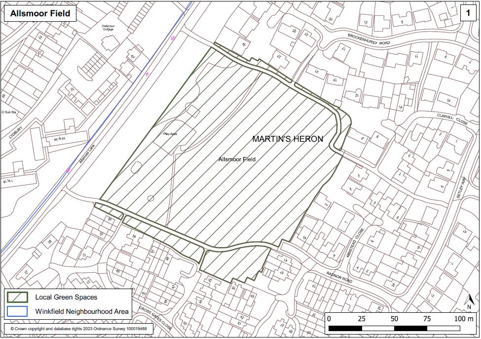
WINKFIELD PARISH NEIGHBOURHOOD PLAN: REFERENDUM VERSION November 2023 97
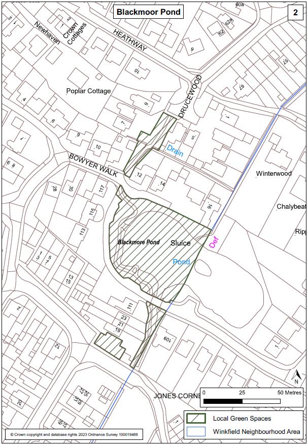
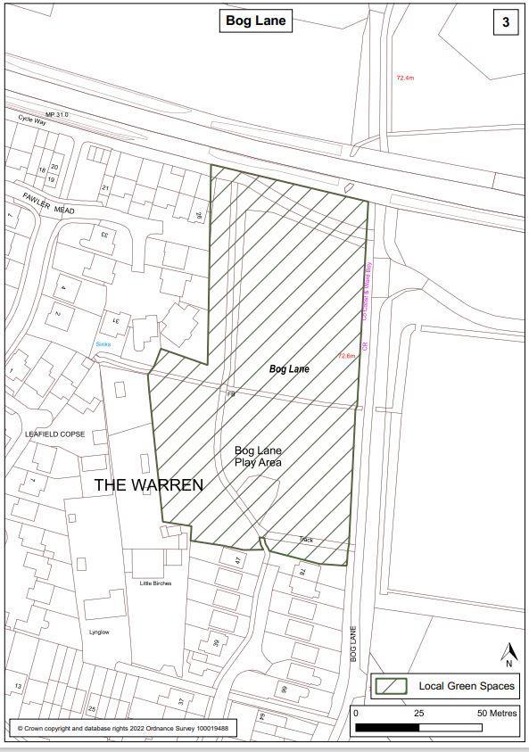
WINKFIELD PARISH NEIGHBOURHOOD
November 2023 98
PLAN: REFERENDUM VERSION
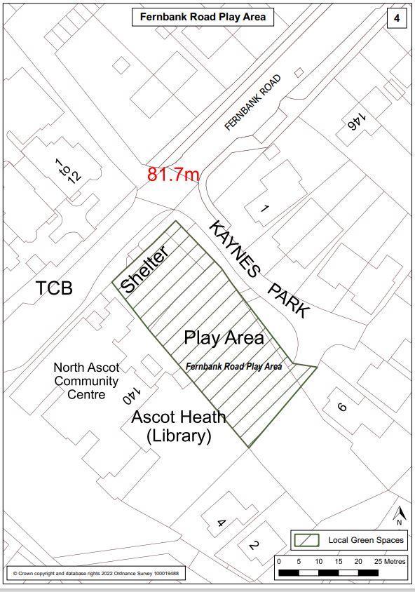
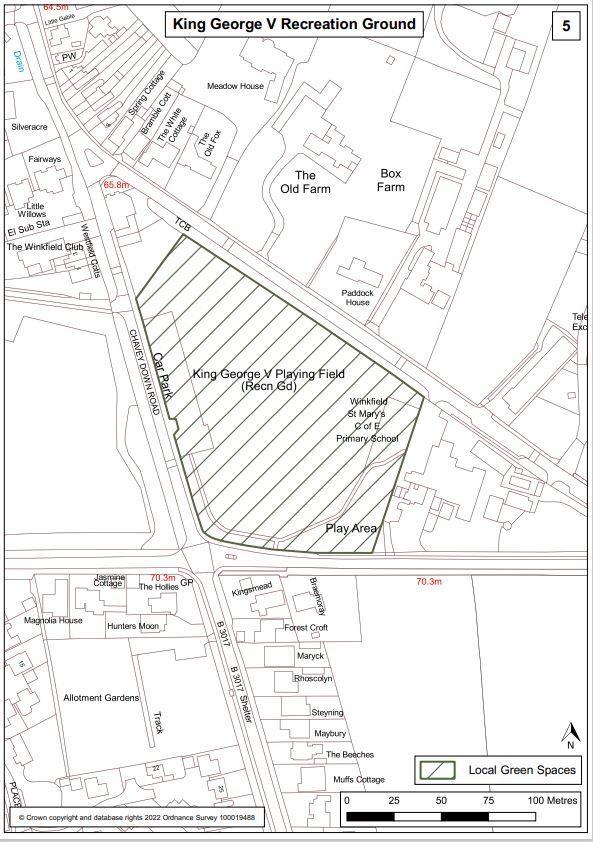
WINKFIELD PARISH NEIGHBOURHOOD PLAN: REFERENDUM VERSION November 2023 99
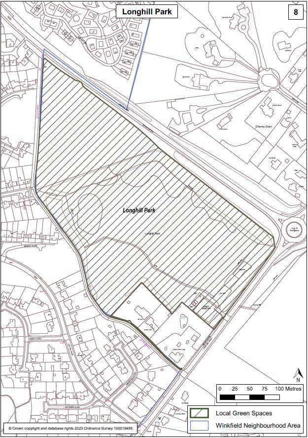
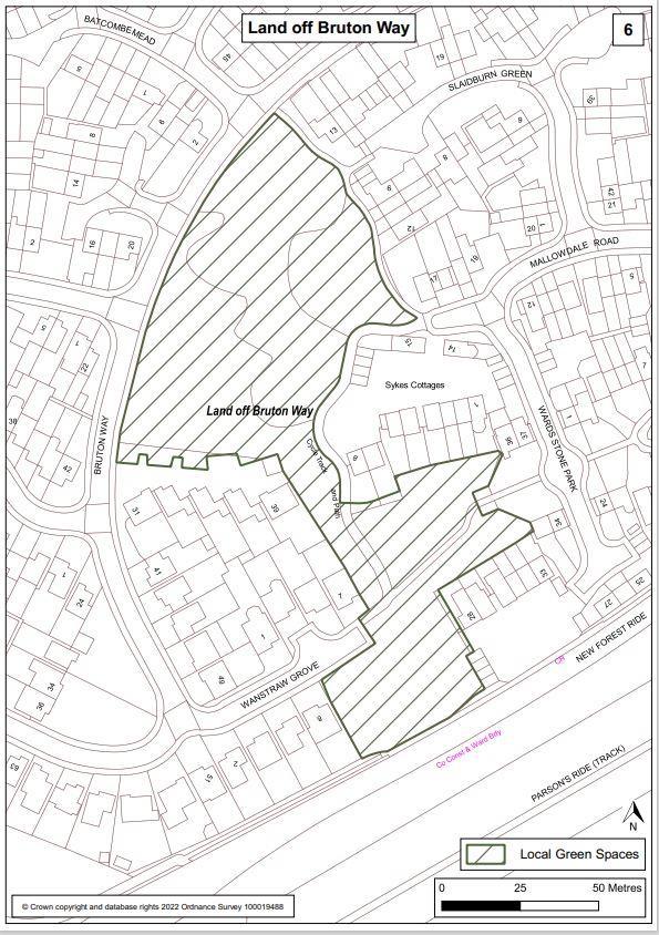
WINKFIELD PARISH NEIGHBOURHOOD PLAN: REFERENDUM VERSION November 2023 100
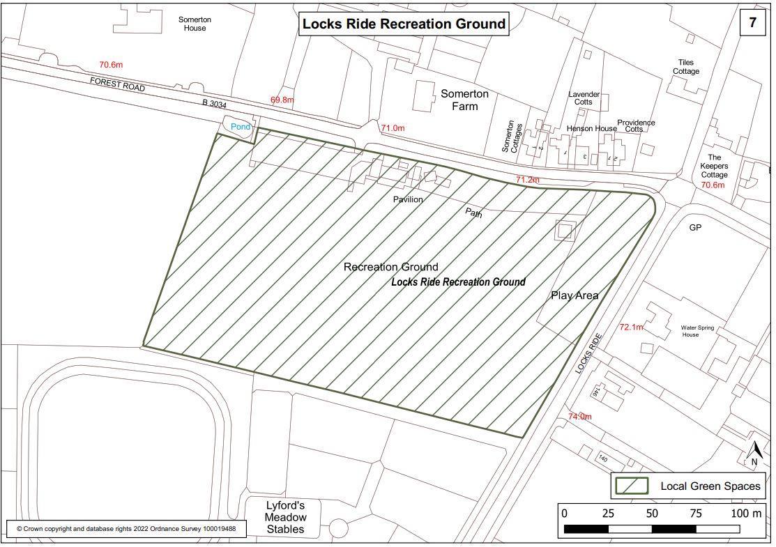
WINKFIELD PARISH NEIGHBOURHOOD PLAN: REFERENDUM VERSION November 2023 101
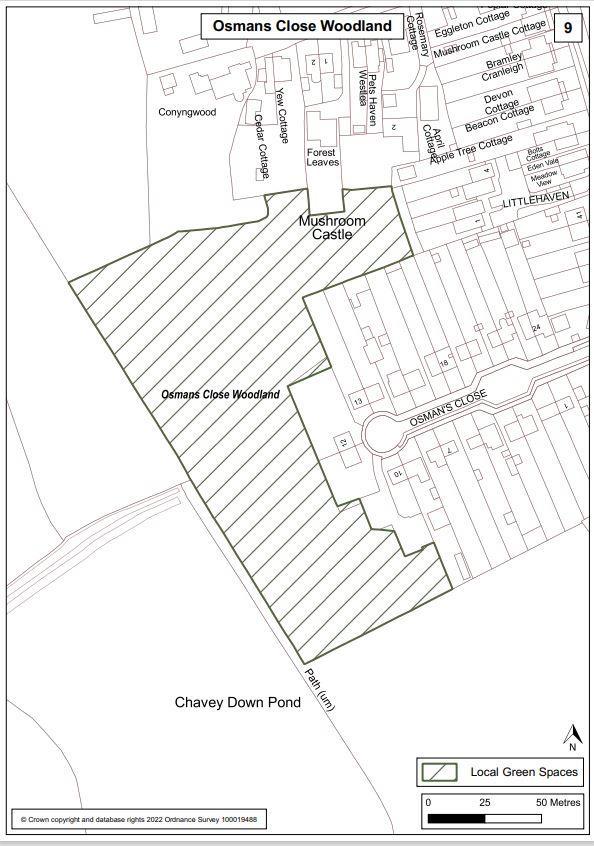
102
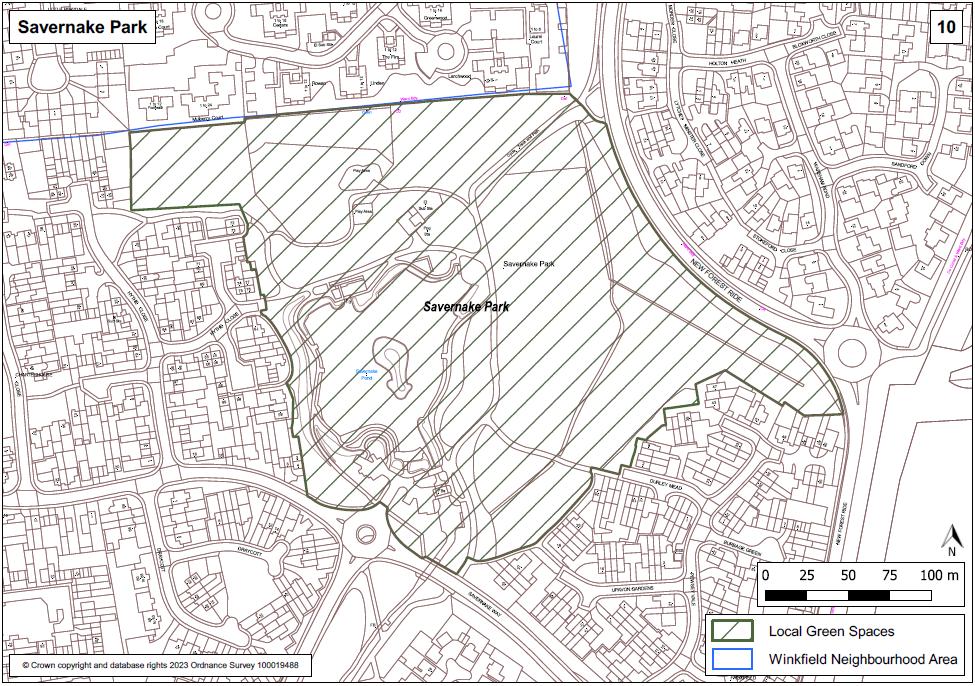
WINKFIELD PARISH NEIGHBOURHOOD PLAN: REFERENDUM VERSION November 2023 103
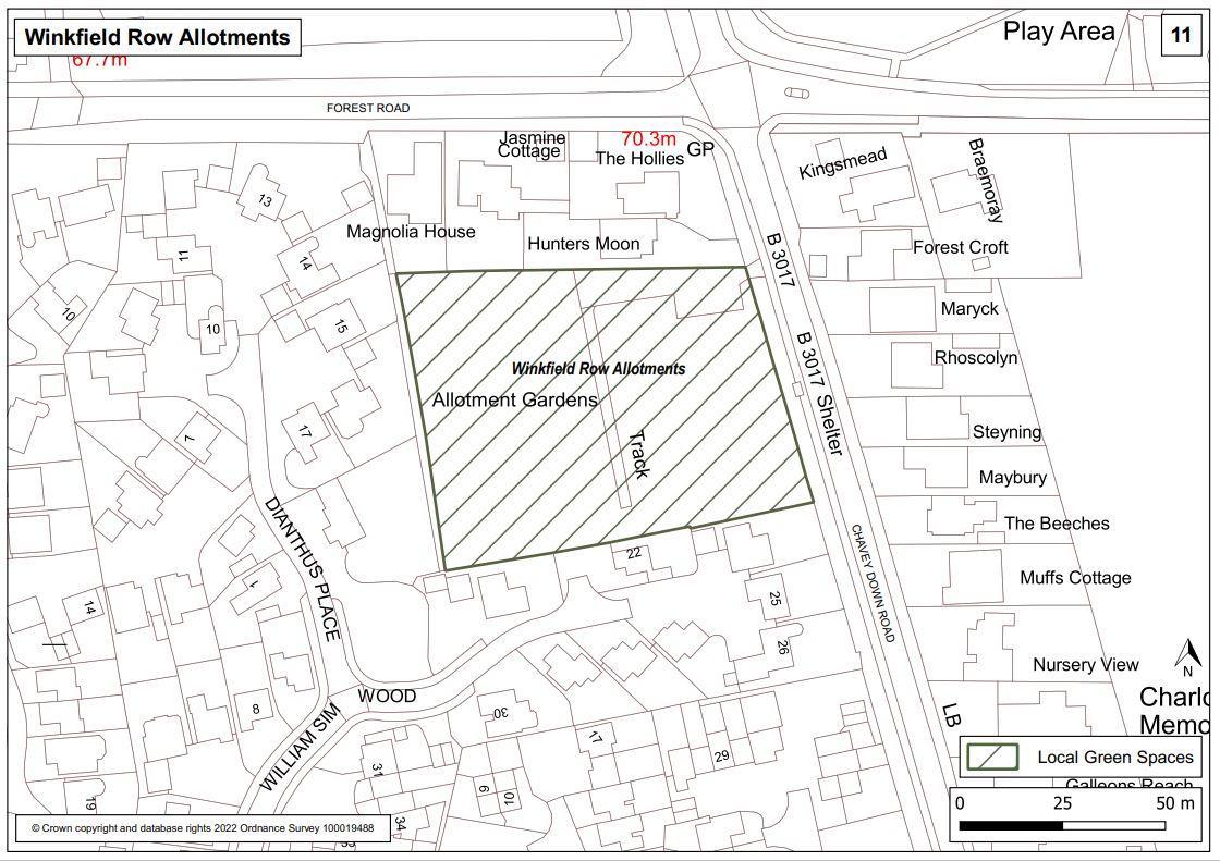
WINKFIELD PARISH NEIGHBOURHOOD PLAN: REFERENDUM VERSION November 2023 104
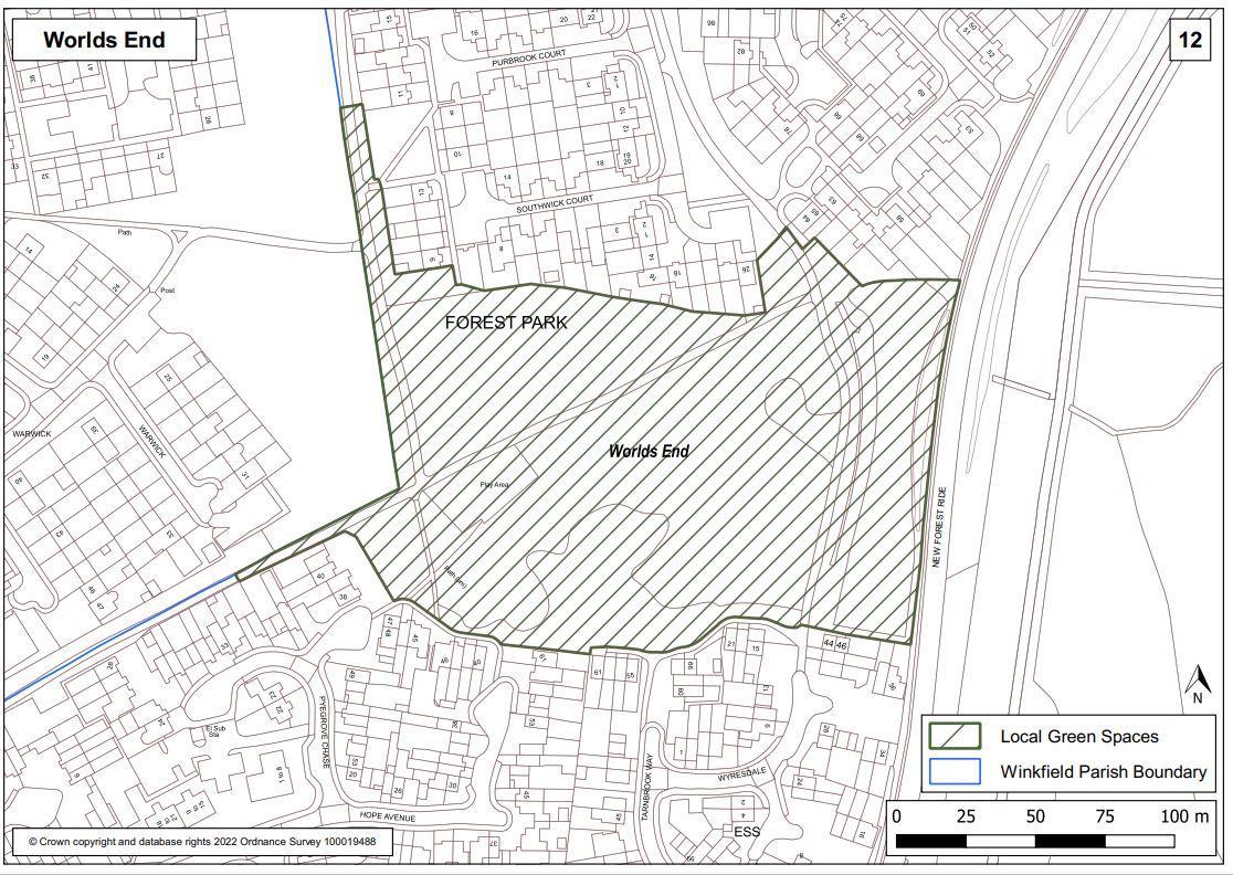
WINKFIELD PARISH NEIGHBOURHOOD PLAN: REFERENDUM VERSION November 2023 105
Appendix B: Schedule of Evidence
The list below contains all documents prepared, collected and reviewed in the process of preparing the WNDP. Links to the evidence base are available on the Winkfield Neighbourhood Development Plan website.
Consultation Statement
Basic Conditions Statement
SEA – screening determination, draft scoping report, final scoping report and SEA
HRA – screening determination and appropriate assessment
WNDP Steering Group Visioning Paper V5 (May 2016)
WNDP Community Questionnaire (2016)
WNDP Summary & Results of Questionnaire, prepared by IDA Consulting Limited (2016)
Winkfield Parish Council 3-year Plan 2017-20
BFC SHELAA (Strategic Housing & Economic Land Availability Assessment) (Nov 2016 V2)
WNDP Consultation/Presentation 18th & 25th Nov 2017 Questionnaire & Results (2017)
Call for Small Sites – WNDP Site Assessment Summary (Jan 2018)
BFC SEA/HRA Screening Report (October 2016)
WNDP SA Draft Scoping Report (October 2017)
WNDP SA Scoping Report (January 2018)
Strategic Environmental Assessment (SEA) of the Winkfield Neighbourhood Plan Environmental Report (2022)
Bracknell Forest SHELAA (August 2017 V2)
Statement from WNDP Steering Group NOT to put forward any Small Sites (July 2018)
WNDP Topic Group (FINAL VERSIONS):
• Community Facilities Document v12 (Feb 2018)
• Green Infrastructure and Landscape Assessment v17
• Green Infrastructure Cycle Route Proposals v18
• Green Infrastructure and Landscape v17
• Housing & Employment v2
• Parking and Traffic v12.1
• Design & Character (Jan 2018)
o Character Assessments:
i. Brock Hill
ii. Chavey Down East (The Village)
iii. Chavey Down Road (Winkfield Row)
iv. Chavey Down West
v. Cranbourne North Street
vi. Forest Park
vii. Kings Ride
viii. Locks Ride
ix. Lovel Road
x. Maidens Green
xi. Martins Heron and The Warren
xii. North Ascot North
xiii. North Ascot South
xiv. Winkfield St Mary's
xv. Winkfield Row North
WINKFIELD PARISH NEIGHBOURHOOD PLAN: REFERENDUM VERSION November 2023 106
Heritage Asset/Nomination Form + Procedure Documents & Local Listing of Buildings and Structures of Local Architectural or Historic Interest within the Parish of Winkfield (with guidance from Historic England Guidance Document).
WINKFIELD PARISH NEIGHBOURHOOD PLAN: REFERENDUM VERSION November 2023 107
THIS PAGE IS INTENTIONALLY BLANK
WINKFIELD PARISH NEIGHBOURHOOD PLAN: REFERENDUM VERSION November 2023 108
