
International Research Journal of Engineering and Technology (IRJET) e-ISSN: 2395-0056
Volume: 12 Issue: 03 | Mar 2025 www.irjet.net p-ISSN: 2395-0072
International Research Journal of Engineering and Technology (IRJET) e-ISSN: 2395-0056
Volume: 12 Issue: 03 | Mar 2025 www.irjet.net p-ISSN: 2395-0072
Abhishek P S1 , Ashna Aboobacker2 , Salman V N3 , Shifana U N4
1,2,3 U G Student, Dept. Of Civil Engineering, Ilahia college of Engineering and Technology, Kerala, India. 4Assistant Professor, Dept. Of Civil Engineering, Ilahia college of Engineering and Technology, Kerala, India.
Abstract – Traffic accidents are a critical public safety concern, resulting in loss of life, property damage and economic cost worldwide. Analyzing the pattern and factors contributingtoaccidentscanhelpidentifyinghigh-riskareas and understanding causes. Geographic Information System (GIS) technology, particularly using ArcGIS software offers powerful tools for spatial analysis and visualization of accident data and enabling more precise and targeted interventions. This project aims to analyze traffic accident data using ArcGIS Pro to identify accident hotspots and visualize accident patterns in State Highway (SH-1) in Muvattupuzha region. Accident trends can be visualized by mapping accident locations and applying spatial analysis techniques like hotspot analysis and Kernal Density Estimation.
Key Words: Traffic accidents, Geographic Information System, ArcGIS Software, Spatial analysis, Kernal Density Estimation
1.INTRODUCTION
Road accidents are a significant global hazard, posing a critical public safetychallenge. The primary causeofroad accidents often include speeding and driving of vehicles undertheinfluenceofalcohol.Thesefactorscontributetoan alarmingnumberoffatalitiesworldwide,withanestimated 1.3 million people losing their lives annually due to road trafficcrashes,equatingtoapproximately3000deathsday.
Variousfactorscontributingtocollisionincludesvehicle design,operationalspeed,roadlayout,weatherconditions, roadenvironmentanddriverbehavior.Thelackofsafeand adequate road infrastructure is a primary cause of road trafficcrashes.Accidentanalysishelpsidentifyingthecauses of accidents, whether single or multiple, with a goal of preventingfutureaccidentsofsimilarnature.
GeographicInformationSystemsoftwareofferspowerful toolforanalyzingaccidentdata.GIStechnologyallowsfor theintegrationofspatialanalysiswithstatisticalmethods, providing valuable insights into accident trends and patterns.By mapping accidentlocations,GISsoftware can identifyareaswithhighconcentrationofaccidentreferredto as “accident hotspots“. Further analysis of these hotspots helps researchers and policy makers understand the underlyingcausesofaccidentsinspecificlocations.ArcGIS,a widelyusedGISsoftware,willbeappliedtoconducttraffic accident analysis. ArcGIS provides tools for mapping,
analyzingandvisualizingspatialdata,makingitpossibleto identify accident patterns. Through ArcGIS, we aim to enhanceourunderstatingofaccidenthotspots
Khaled Aati (2024) explores how urban density affects roadtrafficaccidents,usingadvancedspatialandstatistical tools like Geotech Transport and ArcGIS. The study highlightstheuniquetrafficchallengesindenselypopulated cities,wherehighvehicleandpedestrianvolumes,limited roadspace,andcomplexlayoutscontributetoaccidentrisks. Previous research points to urbanization, infrastructure quality,andtrafficflowaskeyfactorsinfluencingaccident rates. The paper emphasizes the importance of spatial analysis tools in identifying accident hotspots and understandingtrafficpatterns.ByleveragingGIStechnology, urban planners can make data-driven decisions to create saferandmoreefficientroadnetworks,ultimatelyreducing accidentsandimprovingcityresilience.
K. Athiappan (2022) highlightedthatsevereroadcrashes areamajorpublichealthconcern.Toreducetheseincidents, both immediate and long-term countermeasures are necessary. A statistical analysis of accidents in Toronto revealedthatfatalcrashesoftenresultfromharshdriving, lackoffocus,andspeeding.Thestudyusedclusteranalysis toidentifykeyfactorscontributingtoaccidentsandcollected data from 2012 to 2015. By utilizing GIS-based analysis, accident-proneareasandblackspotsweremapped,helping to focus preventive efforts on the most critical causes to reducefuturecrashes.
Md Izharul Haque et al. (2022) conducted a study on trafficsafetyalongNH-76,coveringa93.5kmstretchfrom Udaipur to Chittorgarh in Rajasthan, India. The research aimed to identify the key factors contributing to road accidents by analyzing data from police records between 2017and2019.Variousaspects,suchastimeofoccurrence, accidenttype,andfrequency,wereexamined.Thestudyalso pinpointedaccident-proneareas(blackspots)andsuggested safety improvements, including better pavement maintenance, proper zebra crossings, and enhanced road signs near intersections. The goal was to address design flawsandimproveoverallroadsafetyforusers.
The process begins with selecting a suitable study area, followed by collecting relevant data. After gathering the
International Research Journal of Engineering and Technology (IRJET) e-ISSN: 2395-0056
Volume: 12 Issue: 03 | Mar 2025 www.irjet.net p-ISSN: 2395-0072
necessaryinformation,apreliminarysurveyisconductedto assess the situation. The collected accident data is then analyzedusingGIStechnologytoidentifypatternsandrisk factors.Finally,appropriateaccidentcontrolmeasuresare implementedbasedontheanalysistoenhanceroadsafety.
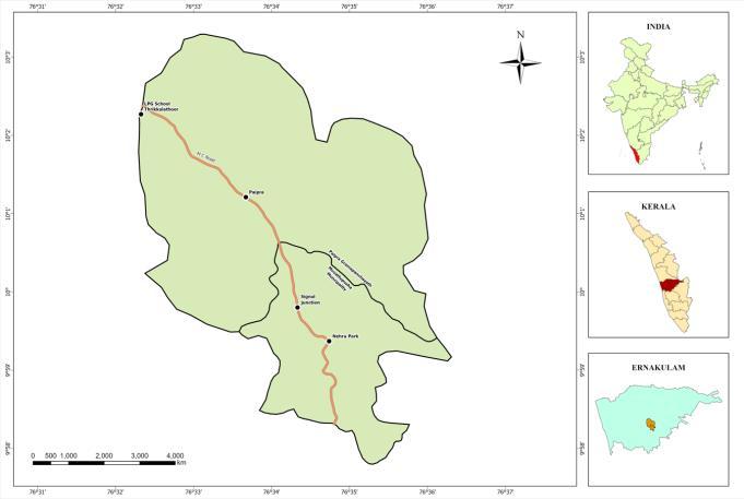
ThestudyareaisunderMuvattupuzhapolicestation. Muvattupuzha police station is situated at Thottumkalpeedika,3kmeastofMuvattupuzhaTown.The area hasnumberof educational institutions, textileshops, retailstores,markets,hospitalsetc,causingtrafficflowinthe city. The study area consists of Paipra Panchayat and Muvattupuzha municipality. Study area is divided into 3 regions. Study Area 1 - Pezhakkapiiy, Study Area 2Vazhappillyandstudyarea3-Velloorkunnam.Thetotalarea foundtobe43.23 sq.km.Itincludesonegrama panchayat and one municipality. The study area lies between 9°59' 21.85362616"Nand10°00'38.26377323"Nlatitudesand 076° 33' 35.43168408"E and76° 36' 18.07850385" E longitudes.
ThemapshowingstudyareaisshowninFig[1].
3.2 DATA COLLECTION
The goal of collecting crash data is to support the blackspot investigation team in understanding the causes andpatternsofroadaccidents,helpingthemimprovesafety and prevent future incidents. Accident data of study area 1,study area 2 and study area 3 for the 5 years 2020,2021,2022,2023 and 2024 were collected from the policestation.Thedatacollectedare:
Dateandtimeofaccident
Typeofvehicleinvolved
Location
Classificationofaccidents:fatal/major/minor
Numberofpeopleinvolved
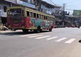
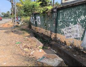
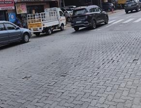
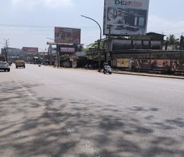
A preliminary assessment was carried out to evaluate the current road conditions in the study area. A survey was carriedout togatherresponsesfromparticipantsregarding variousroad-relatedissues,theirlocations,andsupporting photographicevidence.Thegoalofthisassessmentwasto identify potential safety concerns and areas needing improvement.
Table -1: Siteobservations
Site
StudyArea2
StudyArea3
Observations
Pedestrian crossings are faded,andthereisashortage of parking spaces, making it challenging for both pedestriansanddrivers
The drainage systems along the road are damaged and in poor condition, leading to potentialwateraccumulation
The road surface has noticeable irregularities, which could impact driving comfortandsafety
Faded lane markings create safety risks, particularly in high-trafficzone
Poorly marked pedestrian crossings, along with worn-out lane markings, make navigation difficult for road users. Furthermore, inadequate drainage in certain sections increasestheriskofwaterlogging,affectingbothmotorists andpedestrians.Regularmaintenanceandtimelyrepairsare necessary to enhance road safety and ensure smoother trafficflow.
Research
Volume: 12 Issue: 03 | Mar 2025 www.irjet.net p-ISSN: 2395-0072
Trafficvolumestudyisconductedatstudyarea1(starting pointofstudyarea)andstudyarea3(Endingpointofstudy area).Thestudyisconductedat8:30AM-10:00AM(Peak hour)and1:30PM–3:00PM(offpeakhour).Theresultsof trafficvolumestudyshowsthattrafficvolumeof studyarea 3ishigherthanthatofstudyarea1.
Table -2:Traffic compositionofstudyarea
Study Area Traffic composition of vehicles
TheaccidentdataareanalyzedbyKernalDensityEstimation method in ArcGIS Pro. For Kernal Density Estimation, location coordinates of each accident locations were obtained. All thecoordinatesareplottedinstudyarea are shownin[2]
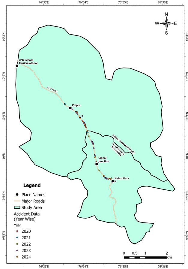
Fig –2:Locationsoftheaccidentsreported
The Kernel Density Estimation (KDE) analysis of the studyarearevealsnotableshiftsinaccidentconcentration over time. The darkest tones in the KDE maps represent accident hotspots, highlighting areas with the highest frequency of incidents. The analysis examines KDE separately for 2020 and 2024, as well as a cumulative assessmentspanning2020to2024.Figures[2],[3],and[4] illustratethespatialandtemporaldistributionofaccidentprone zones. The KDE results indicate that in 2020, the majorityofaccidentsoccurredinStudyArea1.By2024,the distribution of accidents became more balanced between Study Area 1 and Study Area 3. The overall KDE analysis from 2020 to2024identifiesStudyArea 3astheprimary accident-prone region. Additionally, the most hazardous roadsectionswithinthestudyareaaredepictedinFigure [5].
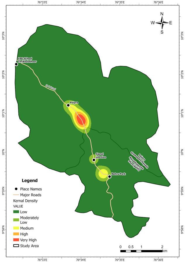
Fig –2:Spatialandtemporaldistributionofaccidents (2020)
International Research Journal of Engineering and Technology (IRJET) e-ISSN: 2395-0056
Volume: 12 Issue: 03 | Mar 2025 www.irjet.net p-ISSN: 2395-0072
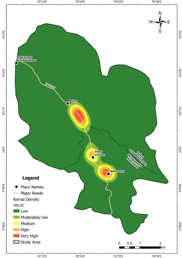
3: Spatialandtemporaldistributionofaccidents (2020)
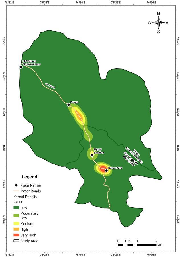
Fig -4:Spatialandtemporaldistributionofaccidents (2020-2024)
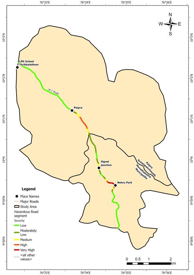
Fig-5:Hazardousroadsegmentinthestudyarea
Theprojectidentifiedthespatial-temporalpatterns ofroadaccidentsbetweentheyears2020and2024under Muvattupuzha police station, Kerala. Initial preliminary survey was carried out within the study area to identify present roadconditions. Using Kernal Density Estimation, themajorvulnerableroadsegmentfoundasStudyArea3Velloorkunnam.Thetwomajoraccident-proneroadsegment observed in the study area are Pezhakkappilly road from paiprajunctionto0.9kmdistance.InVeloorkunnamroad, from signal junction to Nehru park. These hotspots are depicted by the darkest shade (Red), in fig. [5], indicating high concentration of accidents in those locations. Furthermore,otherroadsegmentsinthestudyareaalsohas high Kernal Density, which means that, this road segment may also be considered while treating an hazardous road segment.Thelengthofsegmentsidentifiedwithveryhigh kernaldensityare.39kmandthesegmentswithhighkernal density are 0.9km. There are also several road networks withlow,moderatelylowandmediumkernaldensity.Based onthevalueof kernaldensityalltheaccidentproneroad segmentswereidentified.
[1] Anuj Rajaram Damgir, Dr Ishfaq, Rashid Sheikh, (2022),”Identification of Black spots on a stretch of NH52”,JournalofEmergingTechnologiesandInnovative Research(JETIR),2349-516.
International Research Journal of Engineering and Technology (IRJET) e-ISSN: 2395-0056
Volume: 12 Issue: 03 | Mar 2025 www.irjet.net p-ISSN: 2395-0072
[2] Izharul Haque,M. Khan,A A Singh ,G Dass , Jaglan S, (2022)”Accidentanalysisandroadssafetyaudit.Acase study on NH-76”, Earth and Environmental Science,1086(1),012025
[3] Khaled Aati and Moustafa Houda, ”Analysis of road accidents in dense cities: Geotech Transports and ArcGis”, Transportation Engineering Journal, Volume 16,2024.
[4] Khaula Alkaabi, ”Identification of hotspot areas for traffic accidents and analyzing drivers behavior and road characteristics”, Transportation Research InterdisciplinaryPerspectives,Volume22,2023.
[5] Md Saiful Alam, Nusrat jahan Tabassum, ” Spatial patternidentificationandcrashanalysisofroadtraffic crash hotspots in Ohio”, Transportation Engineering Journal,Volume9,2023.