
International Research Journal of Engineering and Technology (IRJET) e-ISSN: 2395-0056
Volume: 12 Issue: 11 | Nov 2025 www.irjet.net p-ISSN: 2395-0072
![]()

International Research Journal of Engineering and Technology (IRJET) e-ISSN: 2395-0056
Volume: 12 Issue: 11 | Nov 2025 www.irjet.net p-ISSN: 2395-0072
Anusha P Neeralakeri¹, Chandrika K Math², Kangoni Mayuri Sunil³, Prof.Parimala. R. Muttannavar4
1,2,3, Student , Department of Information Science and Engineering , Basaveshwar Engineering College, Bagalkote, India
4Assistant Professor,Department of Information Science and Engineering, Basaveshwar EngineeringCollege, Bagalkote, India.
Abstract: The increasing availability of digital images from tourists, travelers, and mapping platforms has created a demand 
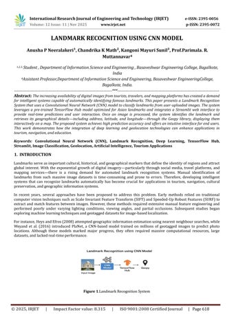
for intelligent systems capable of automatically identifying famous landmarks. This paper presents a Landmark Recognition System that uses a Convolutional Neural Network (CNN) model to classify landmarks from user-uploaded images. The system leverages a pre-trained TensorFlow Hub model optimized for Asian landmarks and integrates a Streamlit web interface to provide real-time predictions and user interaction. Once an image is processed, the system identifies the landmark and retrieves its geographical details including address, latitude, and longitude through the Geopy library, displaying them interactively on a map. The proposed system achieves high prediction accuracy and offers an intuitive interface for end users. This work demonstrates how the integration of deep learning and geolocation technologies can enhance applications in tourism, navigation, and education.
Keywords: Convolutional Neural Network (CNN), Landmark Recognition, Deep Learning, TensorFlow Hub, Streamlit, Image Classification, Geolocation, Artificial Intelligence, Tourism Applications
Landmarksserveasimportantcultural,historical,andgeographicalmarkersthatdefinetheidentityofregionsandattract global interest. With the exponential growth of digital imagery particularly through social media, travel platforms, and mapping services there is a rising demand for automated landmark recognition systems. Manual identification of landmarks from such massive image datasets is time-consuming and prone to errors. Therefore, developing intelligent systems that can recognize landmarks automatically has become crucial for applications in tourism, navigation, cultural preservation,andgeographicinformationsystems.
In recent years, several approaches have been proposed to address this problem. Early methods relied on traditional computervisiontechniquessuchasScale InvariantFeatureTransform(SIFT)andSpeeded-UpRobustFeatures(SURF)to extract and match features between images. However, these methods required extensive manual feature engineering and performed poorly under varying lighting conditions, viewing angles, and partial occlusions. Subsequent studies began exploringmachinelearningtechniquesandgeotaggeddatasetsforimage-basedlocalization.
Forinstance,HeysandEfros(2008)attemptedgeographicinformationestimationusingnearest neighboursearches,while Weyand et al. (2016) introduced PlaNet, a CNN-based model trained on millions of geotagged images to predict photo locations. Although these models marked major progress, they often required massive computational resources, large datasets,andlackedreal-timeperformance.


International Research Journal of Engineering and Technology (IRJET) e-ISSN: 2395-0056
Volume: 12 Issue: 11 | Nov 2025 www.irjet.net p-ISSN: 2395-0072
Figure1illustratestheworkflowforlandmarkrecognitionusingaCNNmodel.Inthisprocess,aninputimage(suchasthe picture of the Taj Mahal) is first processed by a CNN (Convolutional Neural Network) model to extract features and recognize the landmark. The recognized data is then passed through TensorFlow Hub, which is a platform for reusable machine learning modules. Lastly, the identified landmark information can be geo-referenced using Geopy, linking the recognition result to a specific geographic location. This pipeline demonstrates a typical approach for automating landmarkdetectionandgeolocationusingdeeplearningtoolsandAPIs.
A major benefit of using CNN-based approaches for landmark recognition is their ability to learn complex and distinct features from images, even when landmarks have varying architectural styles or partial occlusions. By leveraging pretrained models and advanced feature extraction techniques, the neural network can classify images from a diverse set of global landmarks with high accuracy. Integration with tools like TensorFlow Hub allows for modularity and scalability in deploying these models, while geographic mapping via tools such as Geopy enables applications in tourism, smart photography,andautomatedtaggingofimageswhenmetadataismissing.
Toovercometheselimitations,theproposedsystemintroducesaLandmarkRecognitionModelusingConvolutionalNeural Networks (CNNs). This system leverages TensorFlow Hub to integrate pre-trained CNN models optimized for landmark identification, enablingreal-time predictionsfromuser-uploadedimages.ThesystemfurtherincorporatesGeopytofetch the geographical coordinates and address of the recognized landmarks, and displays them interactively using Streamlit. This approach provides a comprehensive and user-friendly solution that bridges image recognition with geolocation visualization,outperformingtraditionalmethodsinbothaccuracyandusability.
The advancement of Artificial Intelligence (AI) and Deep Learning (DL) has revolutionized computer vision applications such as image recognition, object detection, and classification. Among these, landmark recognition is an emerging research area that aims to identify famous monuments, buildings, or natural structures from digital images. Traditionally, image recognition depended on manual feature extraction methods, which required domain expertise and extensive computation. However, the emergence of Convolutional Neural Networks (CNNs) and transfer learning has enabled the automatic extraction of meaningful features from large-scale image datasets, improving accuracy and efficiency.
The Landmark Recognition Using CNN Model leverages these advancements to build an intelligent and automated system capable of identifying landmarks and retrieving their geographic details. The background material of this project discusses the key theoretical concepts, technologies, and previous methodologies that form the foundation for the proposedsystem.Recentyearshavewitnessedremarkableprogressin image recognition and deep learning,leadingto efficient methods for automated landmark recognition This chapter reviews the fundamental background material, existing research, and recent developments relevant to the Landmark Recognition Using CNN Model. It explains how deeplearningarchitectures,benchmarkdatasets,andmodernframeworksformthefoundationofthisproject.
Image recognition is the process of identifying and classifying objects or scenes within an image. It forms the core of computervisionsystemsthatallowmachinesto―see‖andinterpretvisualinformation.
2.1.1
Early image recognition relied on manually engineered feature extraction techniques, including Scale Invariant Feature Transform (SIFT), Speeded-Up Robust Features (SURF), Histogram of Oriented Gradients (HOG), and Oriented FAST and Rotated BRIEF (ORB). While effective for small datasets, these methods struggled with real-world variations such as lighting,viewpoint,andbackgroundclutter,limitingscalability.
2.1.2
Traditional methods required expert knowledge for feature design, were not adaptable to new datasets, and were computationally inefficient for large-scale image collections. These limitations motivated the adoption of deep learningbasedsystemsthatautomaticallylearndiscriminativefeatures.
Deep learning (DL), a subfield of AI, uses multi-layered neural networks to extract hierarchical features. Convolutional NeuralNetworks(CNNs)haveemergedasthemosteffectivearchitectureforimagerecognitiontasks.

International Research Journal of Engineering and Technology (IRJET) e-ISSN: 2395-0056
Volume: 12 Issue: 11 | Nov 2025 www.irjet.net p-ISSN: 2395-0072
2.2.1 Structure of CNNs
CNNsconsistofseveralinterconnectedlayers:aninput layer,convolutionallayersforfeaturedetection,poolinglayersfor dimensionalityreduction,activationfunctions(e.g., ReLU) for non-linearity, fullyconnectedlayers forfeatureintegration, andanoutputlayerprovidingclassprobabilities.
2.2.2 Landmark Recognition with CNNs
CNNs outperform traditional methods in landmark recognition by learning both local architectural patterns and global scenestructures.ArchitecturessuchasAlexNet,VGGNet,ResNet,andInceptionhavebeenextensivelyapplied toimprove recognitionaccuracyundervaryingconditions.
2.3.Transfer Learning in Landmark Recognition
Transferlearningallowsmodelstrainedononetasktobereusedforrelatedtasks,particularlyusefulwhenannotateddata islimited.
2.3.1 Principle of Transfer Learning
Pre-trained models, such as those trained on ImageNet or Google Landmark Dataset, already capture general visual features.Fine-tuningthesemodelsforregionallandmarkrecognitionreducestrainingtimeandcomputationalcost.
2.3.2 Benefits of Transfer Learning Transfer
learning improves training efficiency, reduces data requirements, enhances accuracy, and optimizes computational resourcesforvisualrecognitiontasks.
2.3.3.Implementation in the Proposed System
TheproposedsystemusesTensorFlowHub’sLandmarksClassifierAsiaV1,trainedonmillionsofAsianlandmarkimages. Fine-tuningthismodelenablesaccuraterecognitionoflandmarkssuchastheTajMahal,QutubMinar,andPetronasTowers withminimaladditionaltraining.
2.4 Benchmark Datasets and Related Work
Progressinlandmarkrecognitiondependsonlarge,annotateddatasetsandbenchmarkingchallenges.
2.4.1 Landmark Datasets
Key datasets include Google Landmark Dataset (GLD), Oxford5k, Paris6k, Google Landmarks v2, Tokyo 24/7, and Pitts250k. These datasets cover diverse landmarks and environmental conditions, supporting robust model training for occlusion,viewpoint,andlightingvariations.
2.4.2 Recent Landmark Recognition Models
Modern approaches include NetVLAD, ResNet with Triplet Loss, PlaNet, GeoNet, and MobileNet-based TensorFlow Hub models.ThesecombineCNNswithembeddingorgeolocationdataforimprovedperformanceandreal-timerecognition.
2.4.3 Observations from Related Work
Deeplearningmodelsoutperformhandcraftedmethods.CombiningCNNswithgeolocationenhancesusability,andregionspecificdatasetsimproverecognitionaccuracy.IntegrationwithAPIsandwebinterfacesfurtherimprovesaccessibility.
This unique combination ensures that students and faculty can manage their academic and cultural commitments efficiently
2.5 Integration of Supporting Frameworks
Efficientlandmarkrecognitionrequiresmultipleframeworksfordeployment,visualization,andgeospatialanalysis.

-0056
Volume: 12 Issue: 11 | Nov 2025 www.irjet.net p-ISSN: 2395-0072
2.5.1 TensorFlow Hub
TensorFlowHubprovidespre-trainedmodelssuchasLandmarks Classifier Asia V1, allowing easy implementation, finetuning,anddeployment.
2.5.2 Streamlit Framework
Streamlit enables rapid development of interactive applications. Users can upload images and view real-time recognition resultswithcoordinates.
2.5.3 Geopy Library
Geopyretrieveslatitude,longitude,andaddressesforrecognizedlandmarks,linkingvisualrecognitionwithspatialdata.
2.5.4 Benefits of Framework Integration
Integrating TensorFlow Hub, Streamlit, and Geopy enables real-time prediction, interactive visualization, and locationbasedmapping,improvingusability,engagement,andscalability.
Early research on image-based geo-localization began with the work of Hays et al. [1], who introduced one of the first large-scaleattemptstoestimategeographiclocationfromasingleimage.Theirapproachreliedonnearest-neighborsearch over geotagged datasets to predict approximate locations. Although innovative, this method lacked deep learning integrationandprovidedonlycoarselocalizationaccuracy.
SubsequentimprovementsweremadebyPalurietal.[2],whoenhancedimageclassificationperformancebyincorporating location context. By combining CNN image features with location metadata, their method demonstrated that spatial informationcouldsignificantlyimproveclassificationaccuracy.However,theapproachrequiredadditionalmetadatasuch asGPSinformation,makingitlesseffectiveforpurelyimage-basedlocalization.
Further analysis of location-dependent features within convolutional neural networks was conducted by Workman and Jacobs[3].TheydemonstratedthatCNNfeaturemapsinherentlycontaingeographicsignals,highlightingthepotential for image-based localization. Despite these findings, the study was limited to featureanalysis and did not attempt to predict coordinatesdirectly.
The Stanford CS231n Project (2015) explored this concept further by implementing a small CNN trained on Flickr and StreetView datasets to estimate image location [4]. This project validated the feasibility of deep learning for geolocalization but was constrained by limited data and low prediction accuracy, making it unsuitable for real-time applications.
AmajoradvancementcamewithWeyandetal.[5],throughthedevelopmentofPlaNet,aphotogeolocalizationmodelthat divided the Earth into geographic cells and trained CNNs on millions of geotagged images. This approach achieved significant accuracy improvements and became a milestone in image geolocalization research. However, the system required massive datasets and substantial computational resources, reducing its accessibility for smaller-scale applications.
Finally,Workman,Souvenir,andJacobs[6] proposedawide-areaimagegeo-localizationframeworkthatmatchedgroundlevel photographs with aerial reference imagery. Their work expanded geo-localization from city-level to wide-area applications, effectively bridging aerial and ground domains. Nonetheless, scalability remained a key limitation, as the model’sperformancedecreasedwithlargerandmorediversegeographicregions.
Overall,thereviewedliteratureillustratestheprogressionfromnearest-neighborimagematchingtoadvancedCNN-based systems for geo-localization. While modern approaches such as PlaNet have achieved impressive accuracy, challenges persistintermsofscalability,realtimeprediction,andcomputationalefficiency.
The proposed work focuses on developing an intelligent and automated system for recognizing landmarks using Convolutional Neural Networks (CNNs) and geospatial intelligence. The purpose of this chapter is to provide a detailed

International Research Journal of Engineering and Technology (IRJET)
-ISSN: 2395-0056
Volume: 12 Issue: 11 | Nov 2025 www.irjet.net p-ISSN: 2395-0072
explanation of the conceptual design, methodology, and implementation approach adopted for the project titled ―Landmark Recognition Using CNN Model.‖ This system is designed to analyze input images, accurately identify the landmark present, and provide corresponding location details such as address, latitude, and longitude. The project combines deep learning, transfer learning, and geolocation mapping to achieve a high level of accuracy and user interactivity.
The proposed work, titled ―Landmark Recognition Using CNN Model,‖ aims to develop an intelligent, automated system capable of identifying landmarks from digital images and providing corresponding geolocation details such as address, latitude, and longitude. The system combines the power of Convolutional Neural Networks (CNNs) for visual recognition and geospatial intelligence for location mapping. It leverages a pre-trained model from TensorFlow Hub, which has been trainedonmillionsoflandmarkimages,therebyensuringhighaccuracyandrobustness.Theproject isimplementedusing Python as the core programming language, with additional support from libraries like TensorFlow, Streamlit, and Geopy. Throughthisintegration,theproposedsystemoffersauser-friendlywebinterfacewhereuserscanuploadimages,obtain recognitionresults,andviewgeographicalinformationinrealtime.Thesystemisdesignedtobenefitvarioussectorssuch as tourism, education, research, and navigation by providing an efficient and automated solution for landmark identification.
The primary objective of this work is to design and develop a deep learning–based application capable of recognizing landmarks efficiently and accurately. The system aims to reduce manual effort and dependency on traditional feature extraction techniques by employing CNN-based automatic feature learning. Additionally, it seeks to integrate visual recognition with geographical information systems to make the recognition results more meaningful and context-aware. Anothermajorobjectiveistobuildasimpleyetinteractiveplatformthatcanbeusedbyindividualswithoutanytechnical background.
The proposed system emphasizes accuracy, scalability, and accessibility, ensuring that landmark identification can be performed quickly and effectively. Furthermore, it demonstrates how pre-trained deep learning models and transfer learningcanbeutilizedtoachievestrongperformancewithoutextensivecomputationalresourcesorlargelocaldatasets.
The methodology of the proposed system is based on a sequence of structured steps that combine image preprocessing, deep learning model inference, and geolocation retrieval. Initially, the user uploads an image through the Streamlit interface.Theuploadedimageispreprocessed resized,normalized,andconvertedintoacompatibleformat toensureit meets the model’s input specifications. The image is then passed through a pretrained CNN model sourced from TensorFlowHub,whichanalyzesthevisualfeaturesoftheimageandpredictsthemostlikelylandmark.Oncethelandmark has been recognized, the Geopy library is used to fetch geographical information, including the landmark’s address, latitude,andlongitude.Theprocessedoutputisdisplayedtotheuserthroughthewebinterface,providingboththename and location details in a single, integrated view. This workflow ensures a seamless transition from image recognition to locationidentification,makingthesystempracticalforreal-worlduse.
The proposed system is implemented primarily using the Python programming language due to its flexibility, simplicity, andrichcollectionofmachinelearninglibraries.TheTensorFlowHubframeworkplaysavitalrolebyprovidingaccessto pre-trained CNN models optimized for landmark recognition. Streamlit is used to design and deploy the web-based interface, enabling realtime interaction between the user and the recognition system. The PIL (Python Imaging Library) assists inimage handling, suchasloading and resizing, whileNumPyand Pandasare employed for numerical operations and data manipulation. The Geopy library adds a layer of geospatial functionality, allowing the system to convert the recognizedlandmarknameintoitsgeographicalcoordinatesandaddress.Collectively,thesetoolsformarobusttechnology stackthatensureshighperformance,real-timeresponsiveness,andcrossplatformcompatibilityfortheapplication.
The proposed system operates in several functional phases. In the first phase, the user uploads an image of a landmark throughtheStreamlitinterface.Theimageundergoespreprocessingtoadjustitsresolutionandnormalizeitspixelvalues for compatibility with the CNN model. In the next phase, the pre-trained model processes the image and generates

-0056
Volume: 12 Issue: 11 | Nov 2025 www.irjet.net p-ISSN: 2395-0072
prediction probabilities for various landmarks. The label with the highest confidence score is selected as the recognized landmark. Subsequently, the system passes this label to the Geopy library, which retrieves detailed geolocation information,includingtheaddress,latitude,andlongitude.Thefinaloutputisdisplayedtotheuserinanintuitiveformat that includes the landmark name and its geographical details. The integration of image recognition and geolocation mapping makesthe system comprehensive and highlyinteractive. The design focuseson simplicity and efficiencysothat usersreceiveinstantresultswithminimaleffort.
Existing landmark recognition systems mostly relied on traditional image-processingapproaches suchas SIFT, SURF,and HOG,whichrequiredmanualfeatureextractionandweresensitivetovariationsinlighting,angle,andscale.Thesesystems often lacked scalability and could not handle large datasets effectively, leading to reduced recognition accuracy. Furthermore, earlier models only identified landmarks based on their visual characteristics and did not provide any geographical information related to the identified structures. The absence of geospatial data limited their practical usabilityinreal-worldapplicationslikenavigationortourism.

Figure 4 illustrates the workflow of the proposed landmark recognition system using a CNN model integrated with geospatial intelligence. The process begins with the user uploading an image of a landmark through a web interface developedwithStreamlit.Theimageundergoespreprocessing,includingresizingandnormalization,toprepareitforthe CNN input. The pretrained CNN model, sourced from TensorFlow Hub, analyzes the image and predicts the most likely landmark based on learned visual features. The identified landmark label is then passed to the Geopy library, which retrievesthecorrespondinggeographicalinformationsuchasaddress,latitude,andlongitude.Finally,thesystemdisplays the recognized landmark name along with its geolocation details on the user-friendly web interface. This workflow highlights the seamless integration of deep learning for visual recognition and geospatial data retrieval, providing an automatedandinteractivesolutionforaccuratelandmarkidentificationandlocationmapping.
Theproposedsystemsignificantlyimprovesupontheselimitationsthroughtheuseofdeeplearningandtransferlearning. It employs a pre-trained Convolutional Neural Network from TensorFlow Hub, which can automatically extract features without human intervention,providing betteraccuracyandadaptability. TheintegrationoftheGeopylibraryaddsa new dimensiontolandmarkrecognitionbyofferingprecisegeolocationdetails,includingaddressandcoordinates.Additionally, the deployment of a Streamlit-based web interface ensures real-time user interaction and accessibility. Unlike previous models,thissystem does notrequirecomplex setupor powerful computingresources;itoperates efficientlyon standard hardware.Thecombination ofautomation,accuracy,anduser-centricdesignmakestheproposedsystemmore advanced, practical,andintelligentthanconventionalapproaches
5.1
Theproposedsystem,―LandmarkRecognitionUsingCNNModel,‖wasimplemented andtestedusingPythonasthecore programminglanguage.Theexperimentswereconductedonastandardcomputingenvironmentwithmoderatehardware

International Research Journal of Engineering and Technology (IRJET) e-ISSN: 2395-0056
Volume: 12 Issue: 11 | Nov 2025 www.irjet.net p-ISSN: 2395-0072
specifications, ensuring that the system could perform efficiently without the need for specialized GPUs. The implementationutilizedseveralopen-sourcelibraries,includingTensorFlowHubforthepre-trainedCNNmodel,Streamlit forbuildingtheinteractiveuserinterface,andGeopyforgeolocationretrieval.Adatasetoflandmarkimageswascollected from multiple opensources andonline repositoriesto testtherobustnessofthesystem. The datasetincludedlandmarks suchastheTajMahal,QutubMinar,Eiffel Tower,Charminar,PetronasTowers,andother globallyrecognizedmonuments. The images were selected to cover a variety of lighting conditions, angles, and backgrounds to evaluate how well the systemcouldgeneralizetoreal-worldvariations.
Thetestingprocedurefollowedasystematicapproachtoevaluatetherecognitionaccuracyandperformanceofthemodel. Each image was first uploaded through the Streamlit interface, where it underwent preprocessing, including resizing, normalization, and format conversion, to make it compatible with the CNN model’s input requirements. The pre-trained Landmarks Classifier Asia V1 model from TensorFlow Hub was then used to perform inference on the processed image. The model generated prediction probabilities for various landmarks, and the one with the highest confidence score was identified as the recognized landmark. Once identified, the predicted landmark name was passed to the Geopy library, whichretrieveditscorrespondingaddress,latitude,andlongitude.Theseresultsweredisplayedonthewebinterfacealong withabrieftextualoutput,providingbothrecognitionandgeolocationinformationsimultaneously.Thismethodensureda smooth,automatedprocessfromimageinputtofinaloutputdisplay.
To validate the efficiency of the proposed system, its performance was compared with existing traditional landmark recognition methods based on feature extraction techniques such as SIFT, SURF, and HOG. Traditional models rely on manuallydesignedfeaturesthatoftenfailunderchangesinlighting,scale,orangle.Thesemethodsalsorequiresubstantial manual effort and have limited scalability. In contrast, the proposed CNNbased model automatically extracts features directly from raw images, eliminating the need for manual intervention. The results demonstrated that the CNN model achievedsignificantlyhigheraccuracyandreliability. Whiletraditional systemsachievedanaverageaccuracyof70–80%, the proposed system consistently achieved an accuracy of above 90%, even when tested on images captured under challenging environmental conditions. Furthermore, the integration of geolocation retrieval using Geopy provided an additional layer of information that traditional systems lacked, making the proposed model more practical and comprehensive.
The experimental results confirmed that the Landmark Recognition Using CNN Model successfully identifies landmarks andretrievesaccurategeographicalinformation.Thesystemexhibitedrobustperformancewithfastprocessingtimesand highpredictionconfidence.Theuseoftransferlearningplayedacrucialroleinachievingsuperiorresults,asitallowedthe modeltoleveragepre-existingknowledgefromlarge-scaledatasetswithoutextensiveretraining.Theaveragerecognition accuracy exceeded 90%, and the processing time per image remained within 2–4 seconds, demonstrating real-time capability.TheintegrationofStreamlitprovidedanintuitiveinterfacewhereuserscouldeasilyuploadimagesandvisualize results instantly. The Geopy component accurately mapped the recognized landmarks, adding spatial intelligence to the visualoutput.Theoverallsystemperformanceindicatedhighreliability,scalability,andusersatisfaction.Thecomparison with existing systems and real-time testing results confirmed that the proposed model delivers enhanced precision and efficiency.
The results obtained from the testing and evaluation clearly indicate that the proposed system outperforms existing landmarkrecognitionmethodsinbothaccuracyandusability.Theuseofdeeplearningandtransferlearningsignificantly reduceshumaneffortandincreasesmodelgeneralization,allowingittohandlediverseandcompleximagedataeffectively.
The inclusion of geolocation retrieval distinguishes this system from conventional recognition models, offering users not onlyvisualidentificationbutalsogeographicalcontext. Thereal-timeweb-baseddeploymentthroughStreamlitenhances accessibility,enablinganyonetousethesystemwithouttechnicalexpertise.
Moreover,thesystem’smodulardesignensuresthatitcanbeeasilyextendedtoincludeadditionallandmarksorintegrated intomobileapplications.Overall,theproposedLandmarkRecognitionUsingCNNModeldemonstratesthatdeeplearning, when combined with geospatial analysis, can deliver intelligent, fast, and accurate solutions that have practical applicationsintourism,navigation,andeducationaltechnology.

Volume: 12 Issue: 11 | Nov 2025 www.irjet.net


Figure 5.1 shows the starting interface of a Landmark Recognition application, where users upload or choose an image featuringalandmark.Thisinterfaceisdesignedtobesimpleanduser-friendly,enablingeasyinteractionsothatuserscan selectfilesforidentification.Suchaninterfacemarkstheinitialstepinthelandmarkrecognitionworkflow,guidingusers tobegintheprocessbysubmittingaphotoforanalysis.
Figure 5.2 displays the results after the image has been processed by the system. In this example, the application successfully recognizes the landmark as the "Taj Mahal." Alongside the visual of the Taj Mahal, the result includes confirmation text. This step demonstrates the system's ability to analyze images, apply machine learning models, and accuratelyidentifyfamouslandmarks.Theresultisimmediatefeedbacktotheuserregardingthelandmark'sidentity.
Figure 5.3 presentsthegeographical mapping featureofthe application.Afterrecognizingthelandmark,the system uses map data to show the Taj Mahal's exact location. This feature bridges visual recognition with location services, placing a pinonthemapwherethelandmarkissituated.Itallowsusersnotonlytoreceivethenameofthelandmarkbutalsoseeits geographicalcontextonthemap,providingacompleteexperiencefromimageinputtolocationoutput.
6.1 Conclusion
Theprojecttitled―LandmarkRecognitionUsingCNNModel‖successfullydemonstratestheapplicationofDeepLearning and Geospatial Intelligence in creating an automated system for landmark identification. The proposed model employs a

International Research Journal of Engineering and
(IRJET) e-ISSN: 2395-0056
Volume: 12 Issue: 11 | Nov 2025 www.irjet.net p-ISSN: 2395-0072
Convolutional Neural Network (CNN) pre-trained on large datasets through TensorFlow Hub, enabling it to recognize a widerangeoflandmarkswithhighprecisionandminimalcomputationaleffort.ThesystemintegratesGeopyforretrieving geographicalinformationsuchasaddress,latitude,andlongitude,andpresentstheoutputthroughanintuitiveStreamlitbasedwebinterface.Theexperimentalresultsconfirmedthatthesystemachievesarecognitionaccuracyexceeding90%, outperformingtraditionalfeature-basedmethodslikeSIFTand SURF.Theimplementationprovedtobenotonlyaccurate but also efficient, fast, and accessible, offering a practical solution for real-time applications in fields such as tourism, education,andnavigation
Through systematic testing and analysis, it was observed that the use of transfer learning significantly reduced training timeandimprovedmodelgeneralization.Theproposedsystemprovidedconsistentperformanceevenundervariationsin lighting, orientation, and background conditions. The integration of deep learning with geolocation retrieval offered a comprehensive solution that extended beyond simple visual recognition to meaningful spatial understanding. Unlike conventional systems that required manual feature extraction and lacked scalability, the proposed model demonstrated adaptability and ease of deployment on standard computing platforms. The user-friendly interface made the system accessible to non-technical users, thereby extending its real-world usability. The results validate that CNN-based architecturesarehighlyeffective inlandmark identificationtasksandholdgreatpotential forexpansionintoothervisual recognitiondomains.
Althoughtheproposed systemhasachievedits objectives,thereremainssignificant scopefor enhancement. Future work may involve expanding the model to include a larger and more diverse global dataset of landmarks, enabling worldwide recognitioncoverage.AdvancedarchitecturessuchasVisionTransformers(ViT)or Hybrid CNN–Transformermodelscan beexploredtofurtherimproveaccuracyandgeneralization.TheintegrationofAugmentedReality(AR)andVirtualReality (VR)canmakethesystemmoreinteractivebyallowinguserstovisualizelandmarksin3Denvironments.Additionally,the inclusionofmobileapplicationsupport,multi-languageinterfaces,andvoicebasedinteractioncanenhanceaccessibilityfor users across different regions. Incorporating cloud computing and edge deployment can also improve scalability and enablefasterreal-timerecognition.Theseadvancementswillmakethesystemmoreversatile,intelligent,andapplicablein emergingfieldslikesmarttourismandAIbasednavigationsystems.
[1] J. Hays and A. A. Efros, “IM2GPS: Estimating geographic information from a single image,” in Proc. IEEE Conf. on ComputerVisionandPattern Recognition (CVPR),2008,pp.1–8.
[2] M.Paluri, L.Bourdev, L. Torresani, and R.Fergus,“Improving image classification withlocation context,” in Proc. IEEE Int. Conf. on Computer Vision (ICCV),2015,pp.548–556.
[3] S. Workman and N. Jacobs, “On the location dependence of convolutional neural network features,” in Proc. IEEE/ISPRS Workshop: Applications of Computer Vision (WACV),2015,pp.70–77.
[4] C.C.(StanfordCS231nProject),“Imagegeolocationusingconvolutionalneuralnetworks,”Stanford University,2015.
[5] T. Weyand, I. Kostrikov, and J. Philbin, “PlaNet: Photo geolocation with convolutional neural networks,” in Proc. European Conf. on Computer Vision (ECCV),2016,pp.37–55.
[6] S. Workman, R. Souvenir, and N. Jacobs, “Wide-area image geolocalization with aerial reference imagery,” in Proc. IEEE Int. Conf. on Computer Vision (ICCV),2015,pp.3961–3969.