International Research Journal of Engineering and Technology (IRJET)
e-ISSN: 2395-0056
Volume: 08 Issue: 06 | June 2021
p-ISSN: 2395-0072
www.irjet.net
INDOOR NAVIGATION SYSTEM USING AUGMENTED REALITY Sandra C J1, Sandra Dileep2, Sithara C S3, Leya Elizabeth Sunny4 1,2,3Student,
Department of Computer Science and Engineering, Mar Athanasius College of Engineering, Kothamangalam, Kerala, India 4Assistant Professor, Department of Computer Science and Technology, Mar Athanasius College of Engineering, Kothamangalam, Kerala, India ---------------------------------------------------------------------***---------------------------------------------------------------------
Abstract - GPS satellite signals are inaccurately trackable
Existing methods for indoor positioning and navigation include using radio wave strength and Bluetooth, magnetic repositioning, position based on visual markers, radio frequency identification (RFID) tags and dead reckoning. However, these methods have huge installation costs and accuracy problems.
for indoor navigation systems. The project's purpose is to design and build an augmented reality-based system for indoor navigation application. The primary purpose is to navigate through various locations within large buildings such as airports, hospitals, shopping malls, and so on, where GPS satellite signals are precisely trackable for navigation applications.The Augmented Reality-based navigation system helps people to align themselves and navigate within large buildings. The technology used is SLAM: Simultaneous Localization and Mapping. The project has four modules: ARCore localisation, QR-code repositioning, Unity Navmesh navigation, and AR path showing. The admin uploads the map and has the ability to place the game objects in Unity.The user scans the QR code using the mobile app and, by selecting the desired destination, the app displays the path to traverse using augmented reality objects (arrows). The app navigates the user through the shortest path using the AStar pathfinding algorithm.
Although the present Global Positioning System (GPS) is typically effective for outside navigation, it is ineffective for inside navigation due to the satellite's low radio wave acceptance. Therefore, it is necessary to use a positioning method other than GPS for indoor navigation.
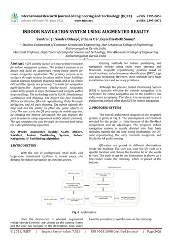
2. PROPOSED SYSTEM The overall architecture diagram of the proposed system is given in Fig. 1. The development environment selected for the project is Unity because of the NavMesh components and its advantages. The proposed indoor navigation system is mainly divided into four basic modules, namely the AR Core based localisation, the QRcode repositioning, the unity navmesh navigation, and finally the AR path showing.
Key Words: Augmented Reality, SLAM, ARCore, NavMesh, Indoor Positioning System, Indoor Navigation, A* Pathfinding Algorithm
QR-codes are placed at different destinations inside the building. The user can scan the QR code at a specific location and choose the location he or she wants to visit. The path to get to the destination is shown as a line-render inside the minimap, which is placed at the bottom.
1.INTRODUCTION With the rise of underground retail malls and large-scale commercial facilities in recent years, the demand for indoor navigation systems has grown.
Fig -1: Architecture Once the destination is selected, augmented reality objects (arrows) are shown on the camera frame and the user can navigate to the destination. Also, users
© 2021, IRJET
|
Impact Factor value: 7.529
have the provision to switch views on the minimap.
|
ISO 9001:2008 Certified Journal
|
Page 2408