International Research Journal of Engineering and Technology (IRJET)
e-ISSN: 2395-0056
Volume: 07 Issue: 04 | Apr 2020
p-ISSN: 2395-0072
www.irjet.net
Indoor Navigation using Path Loss Model and Trilateration Kokila B1, C K Vanamala2 1Student,
MTech-Computer Network and Engineering, Department of IS&E, National Institute of Technology, Mysore, Karnataka, India 2Associate Professor, Department of IS&E, National Institute of Technology, Mysore, Karnataka, India ---------------------------------------------------------------------***----------------------------------------------------------------------
ABSTRACT: Location determination is the most prominent method to find location of the client. GPS is used to find location of outdoor but not suitable for indoor navigation. In this paper, Wi-Fi Positioning System is used to address indoor positioning of the devices.
Key Words: Wi-Fi, RSSI, Trilateration, Access Point, Pathloss model.
Where, PLrs(d) is the path-loss of received signal from the measuring distance ; PLrs(d1) is the path-loss of received signal from the reference distance say d1, n indicated the path loss index and it indicate the speed of the path loss, which is increased along with increasing distance ; α is in dB, it is a cover factor. “RSSI” is given by,
1. INTRODUCTION
RSSI = Ptp− PLrs (d)
To find the indoor-positioning system researches are carried out and IEEE 802.11 WLAN (Wi-Fi) can be used to find Indoor positioning. Wi-Fi and Trilateration method is used to find the position of the client. And the database, “Indoorpositioning database” is used to collect the received signal strength indicator (RSSI) which help to find the distance from the Access point to the client.
where “Ptp” is the signal transmission power.
2. RELATED WORK
“B” indicated the signal strength which is received from reference nodes at the distance d1. B = Ptp− PLrs (d1) And “d” distance is given by, d = 10(B-RSSI)/10n
In most of the paper they have used frequency division multiple access [1][2] and RSSI for finding distance [3][7][8][10]. We are using RSSI parameter to find distance using path-loss model and trilateration method to find the location of the client. 3. METHODOLOGY
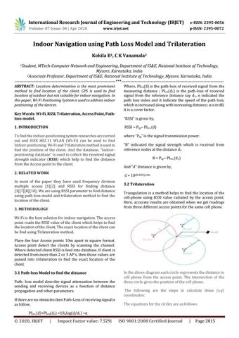
3.2 Trilateration Triangulation is a method helps to find the location of the cell-phone using RSSI value radiated by the access point. Here, accurate results are obtained when we get readings from three different access points for the same cell phone.
Wi-Fi is the best solution for indoor navigation. The access point reads the RSSI value of the client which helps to find the location of the client. The exact location of the client can be find using Trilateration method. Place the four Access points 10m apart in square format. Access point detect the clients by scanning the channel. Where detected client RSSI is feed into database. If client is detected from more than 2 or 3 AP’s, then those values are passed into trilateration to find the exact location of the client. 3.1 Path-loss Model to find the distance Path- loss model describe signal attenuation between the sending and receiving devices as a function of distance propagation and other parameters. If there are no obstacles then Path-Loss of receiving signal is as follow,
In the above diagram each circle represents the distance to cell phone from the access point. The intersection of the three circle gives the position of the cell phone. The following are the steps to calculate these (x,y) coordinates: The equations for the circles are as follows:
PLrs (d)=PLrs(d1) +10nlog(d/d1) +α
© 2020, IRJET
|
Impact Factor value: 7.529|
ISO 9001:2008 Certified Journal
|
Page 2815