International Research Journal of Engineering and Technology (IRJET)
e-ISSN: 2395-0056
Volume: 06 Issue: 07 | July 2019
p-ISSN: 2395-0072
www.irjet.net
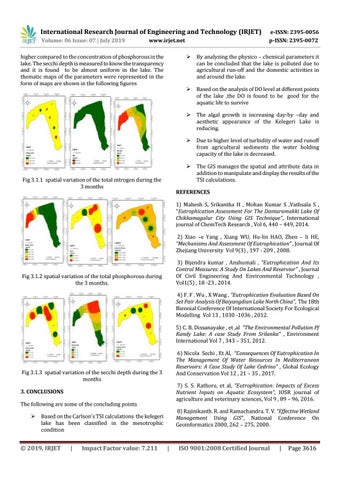
higher compared to the concentration of phosphorous in the lake. The secchi depth is measured to know the transparency and it is found to be almost uniform in the lake. The thematic maps of the parameters were represented in the form of maps are shown in the following figures
Fig 3.1.1 spatial variation of the total nitrogen during the 3 months
By analyzing the physico – chemical parameters it can be concluded that the lake is polluted due to agricultural run-off and the domestic activities in and around the lake.
Based on the analysis of DO level at different points of the lake ,the DO is found to be good for the aquatic life to survive
The algal growth is increasing day-by –day and aesthetic appearance of the Kelegeri Lake is reducing.
Due to higher level of turbidity of water and runoff from agricultural sediments the water holding capacity of the lake is decreased.
The GIS manages the spatial and attribute data in addition to manipulate and display the results of the TSI calculations.
REFERENCES 1) Mahesh S, Srikantha H , Mohan Kumar S ,Vathsala S , “Eutrophication Assessment For The Dantaramakki Lake Of Chikkamagalur City Using GIS Technique”, International journal of ChemTech Research , Vol 6, 440 – 449, 2014. 2) Xiao –e Yang , Xiang WU, Hu-lin HAO, Zhen – li HE, “Mechanisms And Assessment Of Eutrophication” , Journal Of Zhejiang University Vol 9(3) , 197 - 209 , 2008. 3) Bijendra kumar , Anshumali , “Eutrophication And Its Control Measures: A Study On Lakes And Reservior” , Journal Of Civil Engineering And Environmental Technology , Vol1(5) , 18 -23 , 2014.
Fig 3.1.2 spatial variation of the total phosphorous during the 3 months.
4) F. F . Wu , X Wang , “Eutrophication Evaluation Based On Set Pair Analysis Of Baiyangdian Lake North China”, The 18th Biennial Conference Of International Society For Ecological Modelling Vol 13 , 1030 -1036 , 2012. 5) C. B. Dissanayake , et ,al “The Environmental Pollution Pf Kandy Lake: A case Study From Srilanka” , Environment International Vol 7 , 343 – 351, 2012. 6) Nicola Sechi , Et Al, “Consequences Of Eutrophication In The Management Of Water Resources In Mediterranean Reservoirs: A Case Study Of Lake Cedrino” , Global Ecology And Conservation Vol 12 , 21 – 35 , 2017.
Fig 3.1.3 spatial variation of the secchi depth during the 3 months
7) S. S. Rathore, et al, “Eutrophication: Impacts of Excess Nutrient Inputs on Aquatic Ecosystem”, IOSR journal of agriculture and veterinary sciences, Vol 9 , 89 – 96, 2016.
3. CONCLUSIONS The following are some of the concluding points
8) Rajinikanth. R. and Ramachandra. T. V. “Effective Wetland Management Using GIS”, National Conference On Geoinformatics 2000, 262 – 275, 2000.
Based on the Carlson’s TSI calculations the kelegeri lake has been classified in the mesotrophic condition
© 2019, IRJET
|
Impact Factor value: 7.211
|
ISO 9001:2008 Certified Journal
|
Page 3616
