International Research Journal of Engineering and Technology (IRJET)
e-ISSN: 2395-0056
Volume: 06 Issue: 04 | Apr 2019
p-ISSN: 2395-0072
www.irjet.net
ADVANCED WAYPOINTS ANALYTICS FOR AUTOMATED DRONES Subrahmanya H M1, Srinivas G1, Chandan Jayram2 1Dept. of ISE, The National Institute of Engineering, Mysore Professor, Dept of ISE, The National Institute of Engineering, Mysore, Karnataka, India ---------------------------------------------------------------------***---------------------------------------------------------------------2Asst.
Abstract - Currently drones are manually operated. Automating drones to calculate its own waypoints and shortest path is required for building smart drones. We have developed an algorithm which takes coordinates of grid as input, plots waypoints, finds shortest path and helps drones to take this path. It also has various machine learning algorithms for various applications.
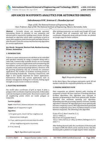
After plotting waypoints, our model uses Google API to get the altitude. Now all waypoints will have all three coordinates. Waypoints along with grid border are plotted on Google maps for better analysis.
Key Words: Waypoint, Shortest Path, Machine learning, Drones, Automation 1. INTRODUCTION A drone is a semi-autonomous aircraft that can be controlled and operated remotely by using a computer along with a radio-link. Commercially-available drones are increasingly been used in a variety of applications such as monitoring and surveillance, search and rescue operations, media coverage of public events, and aerial package delivery. However, with the growing popularity and use of drones for consumer applications, the number of incidents involving drones is also increasing dramatically. Ensuring a hazard-free, safe flight is also equally important for indoor applications. Autonomous drones has various applications such as disaster management, finding fire in forests, finding signal strength around a tower in telecom industry.
Fig-2: Waypoints plotted on map In the above figure, blue polygon represents a grid. All red markers indicate the waypoints plotted by our model.
2. PLOTTING WAYPOINTS
3. FINDING SHORTEST PATH
Our model takes coordinates of grid as input. It plots a polygon with coordinates of grid as end points. It then takes centroid of polygon as initial point. Recursion is used to add all neighboring points which are inside polygon as waypoints.
Once waypoints are plotted, shortest path covering all waypoints is found. We have used two Travelling Salesman Problem algorithms. One algorithm uses concepts of dynamic programming to find most optimal path. Another algorithm uses minimum spanning tree algorithm. Depending upon the processing capacity of drones, suitable algorithm is selected. DP algorithm gives most optimal path but time complexity is more. MST algorithm finds good path but time complexity is less. Here, Euclidean distance is used between waypoints. The following is the algorithm: If size of S is 2, then S must be {1, i}, C(S, i) = dist(1, i) Else if size of S is greater than 2. C(S, i) = min { C(S-{i}, j) + dis(j, i)} where j belongs to S, j != i and j != 1. After finding shortest path, the coordinates of shortest path is output to KML file which can be used by drones. Also this shortest path is plotted on Google map for better analysis.
Fig-1: Algorithm to plot way points
Š 2019, IRJET
|
Impact Factor value: 7.211
|
ISO 9001:2008 Certified Journal
|
Page 1802