International Research Journal of Engineering and Technology (IRJET)
e-ISSN: 2395-0056
Volume: 06 Issue: 12 | Dec 2019
p-ISSN: 2395-0072
www.irjet.net
Modular Rescue and Surveillance Drone Raj Shinde1, Raj Patel2, Abhijit Raut3, Roshan Surukutla4 1Raj
Shinde, M.Eng Robotics, University of Maryland, College Park, Maryland Patel, B.E EXTC, Rajiv Gandhi Inst. of Technology, Mumbai, Maharashtra 3Abhijit Raut, B.E EXTC, Rajiv Gandhi Inst. of Technology, Mumbai, Maharashtra 4Roshan Surukutla, B.E EXTC, Rajiv Gandhi Inst. of Technology, Mumbai, Maharashtra -------------------------------------------------------------------------***-----------------------------------------------------------------------2. BLOCK DIAGRAM Abstract - Nowadays, drones or more specifically Multi2Raj
rotors are an important technology being used in various fields and in many different ways, military is one of the fields that uses UAVs extensively in Surveillance and Rescue operations [2]. One of the limitations faced in such operations is that, some areas cannot be accessed by just the flying ability of drones, in order to make these areas accessible, drones also need to have the ability to navigate on ground like a car. A mechanism to make a drone navigate on ground surface can be easily added, but the weight of the drone also needs to be kept as low as possible to have a longer flight time and high payload carrying capacity. So, a different methodology must be adapted rather than adding motorized wheels. In this paper a different approach is shown, that adds the ability to navigate on ground by just tilting the motors. To demonstrate the approach the mechanism is implemented on a Quadcopter. Additionally, implementation of a LiDAR based 3D-Mapping feature on the drone is discussed, which is capable of creating a 3D-Map of the environment. Furthermore, a feature to add and drop different modules for different applications is explained. Key words: Drone, Robotics, Surveillance, Military, LiDAR 3D-Mapping, Modular.
1. INTRODUCTION Drones being only able to fly, make some areas difficult to be accessed during operations like rescue and surveillance. Hence a mechanism must be developed to add the ability to navigate/move on ground as well, while keeping the weight of the drone as low as possible. So instead of using additional actuators for wheels, the already present actuators i.e. the brushless motors can be used to propel the drone forward and backward. This can be done by tilting the motors using a servo motor. Also, as a drone for rescue and surveillance operation is incomplete without a way to visualize the area and carry payloads, so a 3D-Mapping device based on LiDAR and a slot to attach different modular devices is developed and added to the system. To demonstrate these features, they are implemented on a 250mm H-Frame Quadcopter.
Š 2019, IRJET
|
Impact Factor value: 7.34
|
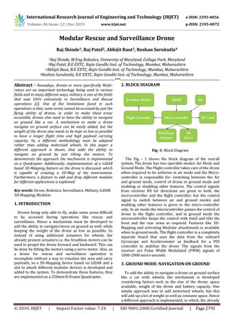
Fig -1: Block Diagram The Fig – 1 shows the block diagram of the overall system. The drone has two operable modes: Air Mode and Ground Mode. The Flight controller takes care of the drone when required to be airborne in air mode and the Microcontroller is responsible for: switching between the Air and ground mode, control of drone in ground mode and enabling or disabling other features. The control signals from receiver RX for directions are given to both, the microcontroller and the flight controller, but the control signal to switch between air and ground modes and enabling other features is given to the micro-controller only. In air mode the microcontroller passes the control of drone to the flight controller, and in ground mode the microcontroller keeps the control with itself and tilts the front and the rear arms as required. Features like 3DMapping and activating Modular attachments is available when in ground mode. The flight controller is a completely separate board that uses the data from the onboard Gyroscope and Accelerometer as feedback for a PID controller to stabilize the drone. The signals from the receiver are Pulse Width Modulated (PWM) signals of 1000-2000 micro-seconds.
3. GROUND MODE: NAVIGATION ON GROUND To add the ability to navigate a drone on ground surface like a car with wheels, the mechanism is developed considering factors such as the size of the drone, space available, weight of the drone and battery capacity. One simple approach was to add motorized wheels, but this will add up a lot of weight as well as consume space. Hence a different approach is implemented, in which, the already
ISO 9001:2008 Certified Journal
|
Page 2792