International Research Journal of Engineering and Technology (IRJET)
e-ISSN: 2395 -0056
Volume: 04 Issue: 04 | Apr -2017
p-ISSN: 2395-0072
www.irjet.net
Bellman Ford Shortest Path Algorithm using Global Positioning System Ms. Kalpana , Mr. Abhishek Tyagi Student, CSE, CET-IILM-AHL, U.P., INDIA -----------------------------------------------------------------***-------------------------------------------------------------
ABSTRACT- Bellman ford Algorithm is used to find the shortest path from one node to another node in a graph. It can be applied on negative weights. In this paper, Global positioning system is used for adding a new functionality in Bellman ford algorithm. In this paper, using Global Positioning System the position parameter is added in the Bellman ford algorithm. From this current position is retrieved at any point. By using this current position, the distance can be determined from one node to another node. For this an algorithm is proposed and the algorithm is compared with Dijkstra’s algorithm which is also used to find out shortest path.
Keywords-Global positioning system (GPS), Bellman ford Algorithm, Dijkstra’s Algorithm, Node and Distance. 1. INTRODUCTION In this we discuss three things, these are:
1.1 Global positioning system(GPS) The Global Positioning was introduced in 1960 under the auspices of the U.S. Airforce, but in 1974 other branches of the U.S. military joined the effort. The Global Positioning System consist of 24 satellites, to provide worldwide position, time and velocity information. GPS makes it possible to precisely identify locations on the earth by measuring distance from the satellites. GPS is used in a variety of ways: To determine the position of locations. To navigate from one location to another. To create digitized maps. To determine the distance between two points.
1.1.1 Working of GPS The basis of GPS is a constellation of satellites that are continuously orbiting around the earth. These equipped with atomic clocks & radio signals that contain their exact location, time and other information. The radio signals which are transmitted from the satellites are monitored & corrected by control stations which are sent back to satellites using ground antenna. The radio signals from satellites are picked up by the GPS receiver. A GPS receiver needs only 3 satellites to plot a rough, 2D position, which will not be very accurate. Ideally, 4 or more satellites are needed to plot 3D positions, which is more accurate than 2D.
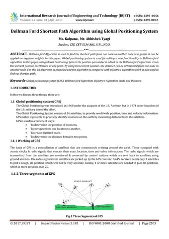
1.1.2 Three segments of GPS
Fig.1 Three Segments of GPS
© 2017, IRJET
|
Impact Factor value: 5.181
|
ISO 9001:2008 Certified Journal
| Page 2503