International Research Journal of Engineering and Technology (IRJET)
e-ISSN: 2395 -0056
Volume: 03 Issue: 08 | Aug -2016
p-ISSN: 2395-0072
www.irjet.net
Flood vulnerability assessment by remote sensing and GIS based applications in West Bengal: A review Arghajeet Saha1, D.V.S.Praneeth2 1M.Tech Scholar,
School of Water Resources, Indian Institute of Technology Kharagpur- 721302, West Bengal, India 2M.Tech Scholar, Department of Civil Engineering, Indian Institute of Technology Kharagpur- 721302, West Bengal, India
---------------------------------------------------------------------***--------------------------------------------------------------------Abstract- Flooding occurs when volume of water within a body of water, such as a river or lake, overflows or breaks levees, with some of the water escaping to its boundaries and causing widespread damage of crops, structures, cattle even leading to the loss of human lives. Floods in India generally occur when water overflows catchments due to high seasonal or unseasonal precipitation. However floods mostly occur in the country during the south-west monsoon period that spreads from June to September accompanying a trail of destruction and hence the losses sustained due to floods have made it a necessity to think of measures to counter the affect. Measures include both structural and non-structural with the latter consisting mainly of Geographic Information System (GIS) and remote sensing applications. A number of research works have thus been carried out all over India which focused on GIS and remote sensing applications starting from flood mapping, flood plain zoning, flood plain, etc. with higher number of works concentrated on post-disaster management. Post–disaster management have been carried out in flood prone West Bengal with works being carried out with objectives of delineating non-flooded areas from flooded areas, high flood depth zones and human settlements to help reduce the post-disaster stress.
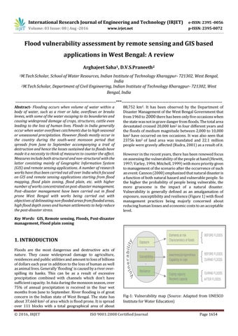
88,752 km2. It has been observed by the Department of Disaster Management of the West Bengal Government that from 1960 to 2000 there has been only five occasions when the state was not in grave danger from floods. The total area devastated crossed 20,000 km2 in four different years and the floods of medium magnitude between 2,000 to 10,000 km2 have occurred on ten occasions. It was also seen that 23756 km2 of land area was inundated and 22.1 million people were gravely affected (Rudra, 2001) as a result of it. However in the recent years, there has been renewed focus on assessing the vulnerability of the people at hand (Hewitt, 1997; Varley, 1994; Mitchell, 1999) with more priority given to management of the scenario after the occurrence of such an event. Cannon (2000) emphasized that natural disaster is a function of both natural hazard and vulnerable people. So the higher the probability of people being vulnerable, the more gruesome is the impact of a natural disaster. Vulnerability is generally defined as an amalgamation of exposure, susceptibility and resilience (Figure 1) with flood management practices being majorly concerned about reducing human losses and economic costs to an acceptable level.
Key Words: GIS, Remote sensing, Floods, Post-disaster management, Flood plain zoning
1. INTRODUCTION Floods are the most dangerous and destructive acts of nature. They cause widespread damage to agriculture, residences and public utilities and amount to loss of billions of dollars each year in addition to the loss of human as well as animal lives. Generally ‘flooding’ is caused by a river overspilling its banks. This can be as a result of excessive precipitation combined with channels which don’t have sufficient capacity. In Asia during the monsoon season, over 75% of annual precipitation is received in the four wet months from June to September. River flooding is of great concern in the Indian state of West Bengal. The state has about 37,660 km2 of area which is flood prone. It is spread over 111 blocks with a total geographical area of about © 2016, IRJET
Fig-1: Vulnerability map (Source: Adapted from UNESCO Institute for Water Education)
ISO 9001:2008 Certified Journal
Page 1654