
International Research Journal of Engineering and Technology (IRJET) e-ISSN: 2395-0056
Volume: 11 Issue: 04 | Apr 2024 www.irjet.net p-ISSN: 2395-0072

International Research Journal of Engineering and Technology (IRJET) e-ISSN: 2395-0056
Volume: 11 Issue: 04 | Apr 2024 www.irjet.net p-ISSN: 2395-0072
Feba James1, Sherin P.V2 ,
1M. Plan Student, Dept of Arch, Govt College of Engineering Thrissur, Kerala, India
2Asst Professor, Dept of Arch, Govt College of Engineering Thrissur Kerala, India
Abstract – The paper aims to develop a river-sensitive master plan for the integrated development of the Periyar River region in Kothamangalam Taluk. To achieve this, the thesis identified the potential of the Periyar River for development while also considering challenges relatedto the river. By analyzing relevant case studies and literature, the paper establishes key parameters for river-sensitive urban planning.Theseparametersareusedto definethestudyarea influenced by the Periyar River. Finally, spatial planning strategies are formulated to achieve the integrated sustainable development of the region, considering the concepts of river-sensitive urban planning.
Key Words: River-sensitive, Spatial Planning
ThePeriyarRiver,stretchingroughly244kilometres,isthe lifeline of central Kerala. This vital waterway not only shapestheregion'ssocioeconomicandecologicalwell-being, but also provides essential resources like hydropower, drinkingwater,irrigation,andhabitatfordiverseplantand animallife.Fromsupportingindustriesandtourismtoacting as a source of natural materials and fisheries, the Periyar RiverisanintegralpartofKerala'sculturalandecological heritage.
ThisPaperaimstocreateariver-sensitivemasterplanfor the development of the Periyar River region in Kothamangalamtaluk.Toachievethis,itwilldelveintothe conceptofriver-centricurbanplanningthroughcasestudies. This analysis will help identify key parameters for incorporatingriverhealthandfunctionalityintodevelopment strategies. Followingthis,theprojectwilldefinethestudy areabasedonthePeriyarRiver'sinfluence.
Within this zone, a comprehensive analysis will be conducted to identify both the potential and the existing issuesrelatedtothechosenparameters.Finally,basedonthis information, the project will formulate spatial planning strategies that promote integrated and river-centric developmentforthePeriyarRiverregioninKothamangalam taluk.
The topic scope targets identifying the potential of the Periyar River for development in Kothamangalam taluk, whilealsoacknowledgingexistingriver-relatedchallenges. This will inform the creation of a plan that integrates the river into the region's future growth. It's important to acknowledgethattheidealstudyareawouldbelarger,but forpracticalreasons,thisprojectwillfocusontheriverbasin withinKothamangalamtaluk,definedusingspecificcriteria. Additionally,theprojectwillconcentrateonspatialplanning aspects that consider the river's health and functionality. The potential and issues within this defined area will be quantified through household surveys, and the resulting proposalswillbebasedonthisprimarydatacollection
River-sensitiveurbanplanningisastrategicapproachto citydevelopmentthatprioritizesthehealthandfunctionality of rivers within the urban landscape. This concept emphasizes two key aspects: The first is to clarify the ambition of the city in this regard, by setting out a broad visionofhowthecityviewsitconnectwiththeriver,within theplanperiod.Thesecondistocreatearobustknowledge andinformationbaselineoftheriveranditsinteractionwith thecity,whichwillhelpinformriver-specificstrategies.After creating this supporting environment, the Master Plan instrumentsandtoolscanbeusedtomainstreamsustainable river health management into the city’s larger long-term vision
This section elaborates on seven such tools and instruments that can be used to ensure river-sensitive developmentwithinacity.
1. Localising National Policies and Initiatives:The nationalorstatepolicieshavingdirectimplications onrivermanagement,needtobelocalized
2. Town-Specific Sectoral: Strategies: Area and issue-specificstrategiesshallbedeveloped,tosuit the local needs, forcustomized implementation of policies
International Research Journal of Engineering and Technology (IRJET) e-ISSN: 2395-0056
Volume: 11 Issue: 04 | Apr 2024 www.irjet.net p-ISSN: 2395-0072
3. Land use assignment: After delineating land use and use zone categories, defining permissible activitiesandallocationoflandbecomesessentialto ensuresystematicplanningandmanagementofthe riverzone
4. Development Control Regulations: Specific building bye-laws, architectural controls, and developmentcontrolsshouldbeframedandadopted forriverzone
5. Norms and standards: Standardisedspecifications andnormsshouldbeadoptedwithintheriverzone to facilitate consistent, restricted and regulated developmentwithintheriverzone
6. Recommendations and directions:thesecouldbe provided to different agencies for specific action takenforrivermanagement
7. Special projects:Specialprojectsfocusedonriversensitivedevelopmentshouldbeidentifiedasmodel projects
The focus of the study lies on the Periyar River basin in Kerala,particularlyinErnakulamdistrict,whichserves as the state's commercial hub and boasts a high population density.WithinErnakulam,KothamangalamTalukhasbeen selected for in-depth analysis due to its proximity to the river and its importance as a tourist destination. Four panchayatssharingboundarieswiththePeriyarRiverwere chosen,totaling37wards.Thestudy'sparameters,derived from thorough analysis, include river flooding, land use, pollutants,andecology.A36kmstretchofthePeriyarRiver, fromNerimangalamto Pindimana within Kothamangalam taluk,isthefocalarea,aimingtoaddressissuessuchasflood risk, sustainable development, pollution sources, and ecologicalpreservation.
KuttampuzhaGramPanchayat,thelargestamongthefour, spans 44,805 hectares with a population of 24,799 distributedacross 16 wards.Notably,ithasa higher male population and a literacy rate of 89.4%, with a significant Scheduled Tribe presence of 4,262 and 1,995 Scheduled Caste members. Surrounding it are various Taluks and districts. Keerampara GP, covering 3,279 hectares, hosts 12,258 residents across 13 wards, with a literacy rate of 84.30%andasmallerbutnotableScheduledCasteandTribe representation. Pindimana GP, spanning 2,179 hectares, accommodates 12,516 inhabitants distributed over 13 wards,boastingaremarkablyhighliteracyrateof97.5%and alsoapresenceofScheduledCasteandTribecommunities.
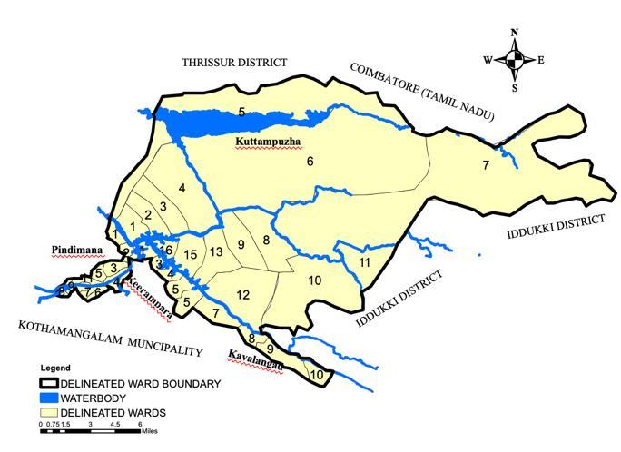
KavalangadGP,over6,320hectares,houses33,394residents across18wards,withaliteracyrateof90.79%,and,likethe others, includes Scheduled Tribe and Caste communities withinitsboundaries.
The vulnerability assessment of the Periyar River basinhighlightsfourkeyparameters.Firstly,theregionfaces significant flood hazards due to its hilly terrain and susceptibility to landslides, placing it within a high to medium flood hazard zone. Secondly, river pollution is a majorconcern,with70%ofindustrialwastewaterdirectly discharged into the river by 16 nearby industries, necessitatingurgentactiontoprotecttheriverecosystem's health.Thirdly,landuseplaysacrucialrole,withimpervious surfaces exacerbating surface runoff and flooding downstream,whilenaturalvegetationhelpsmitigateflood risksandmaintainhabitatconnectivity.Finally,thePeriyar Riverbasinboastsarichecologicaldiversity,includingthe renownedThattekadBirdSanctuary,makingriverecologya vital parameter for identifying areas requiring specific protectionmeasurestoensurethelong-termsustainability oftheecosystemanditsbiodiversity.
International Research Journal of Engineering and Technology (IRJET) e-ISSN: 2395-0056
Volume: 11 Issue: 04 | Apr 2024 www.irjet.net p-ISSN: 2395-0072
Thestudyarea presentsa myriadofpotentialsandissues acrossdifferentdimensions.Intermsoffloodandlandslide risks, the region exhibits medium to high susceptibility, posing threats of property damage and loss of life, exacerbated by sediment buildup during floods and ecological disturbances caused by cyclic flooding and drainingofplains.Riverpollutionisacriticalconcerndueto corroded pipelines and direct discharge of industrial wastewater,leadingtowaterqualityissueshighlightedby theKeralaStatePollutionControlBoard.However,thearea boastsarichecologicalhabitat,includingdiversevegetation and the renowned Thattekkad Bird Sanctuary, presenting opportunitiesforbiodiversityconservationandeco-tourism activities.Inplanningfortheregion'sdevelopment,domestic watersupplyfaceschallengessuchastheabsenceofproper treatment plants and high fecal coliform bacteria content, while irrigation systems suffer from encroachment, canal liningdamage,andblockeddrainage,necessitatingupgrades for reliable water delivery. Additionally, the potential for hydropowergenerationandeco-tourismishinderedbypoor infrastructure and a lack of initiative from relevant departments,exemplifiedbytheunderutilizationofexisting facilities like boat jetties. Addressing these issues while capitalizingonthearea'spotentialiscrucialforsustainable developmentandenvironmentalpreservation
Theanalysisofissuesinthestudyareahasledtothe identification of eight monitoring indicators, collectively forming the River Sensitive Management (RSM) index, crucial for developing strategies to enhance river management.TheRSMindex,measuredonascalefromone tofive,indicatesthelevelofrivermanagement.WithanRSM indexof2.16,fallingwithintherangeof1.6to2.5,thearea demonstrates an elementary level of river management. Basic actions for floodplain management, riparian buffer, eco-friendlyriverfront,andcitizensensitizationarepresent. However,therearenotablegapsandconcernsinalmostall aspectsofrivermanagement,suggestinganeedforfurther interventions to address critical issues such as floodplain management, eco-friendly riverfront development, and citizensensitization.Thiselementarylevelunderscoresthe necessity for comprehensive measures to elevate river management practices in the study area to ensure sustainableandeffectivemanagementofriverresources.
Issue 1: Pollution in rivers and drains: The study areafacessignificantchallengesrelatedtopollutioninrivers and drains, necessitating a comprehensive approach to address these issues. Localizing national policies and initiatives, such as the National Water Policy of 2012, is essential,emphasizingthepreventionofwaterpollutionand
the implementation of stringent punitive actions against polluters. Town-specific sectoral strategies are crucial, including connecting industries to Common Effluent Treatment Plants (CETPs), upgrading corroded sewer pipelines,andincentivizingorganicfarming.Moreover,the establishmentofcompostingpitsinhouseholdsandcleaning programsforaqueductsareimperativeforsustainablewaste managementandsafedrinkingwater.Landuseassignment playsavitalrole,withzoningregulationsdividingactivities intoprohibited,permissible,andregulatedcategories,while developmentcontrolregulationsprescribesetbackdistances fromriversanddrains.Stricteffluentdischargestandards forSewageTreatmentPlants(STPs)arenecessarytoensure compliance with national water quality standards. Additionally, recommendations for inspections and enforcement actions on industries, along with special projects like centralized waste treatment plants, are essentialstepstowardsmitigatingpollutionandpromoting environmentalsustainabilityinthestudyarea.
Issue2:FloodAndLandslideSusceptibility:Addressingthe susceptibility to floods and landslides in the study area requiresamultifacetedstrategy.Localizingnationalpolicies liketheNational DisasterManagementGuidelines2008 is crucial, advocating for floodplain zoning regulations to mitigate risks. Town-specific sectoral strategies entail developinganemergencypreparednessplantailoredtothe area'sneeds.Landusezoningcategorizeszonesintohigh, medium,andlow-riskareas,prohibitingnewconstructionin high-risk zones and mandating flood risk assessments in medium-riskareas.Recommendationsincludeestablishinga floodwarningsystemusingdatafromtheBhothathankettu damandconstructingembankmentsinhigh-riskzoneslike Kuttampuzha GP. Additionally, special projects aim to convertfloodplainsintonaturalwetlandsandrecreational areas,fosteringresilienceagainstfloodingwhileenhancing environmentalsustainabilityandcommunitywell-being.
Issue3:WeakTourismDevelopment:Toaddresstheweak tourism development in the study area, a comprehensive strategyisessential.Localizingnationalpoliciessuchasthe NationalTourismPolicyof2002ispivotal,emphasizingthe enhancement of tourism circuits and preservation of historical and ecological sites. Town-specific sectoral strategiesfocusonpromotingtourismactivitieslikenature trailsalongthePeriyarRiver,adventuresports,andguided tours.Landuseassignmentdivideszonesintocategoriesfor tourismdevelopment,heritagepreservation,andecological conservation,withclearzoningregulationsimplementedto ensure sustainable growth. Norms and standards are established for tourist facilities to maintain sustainability and aesthetics. Recommendations include developing tourism-related infrastructure and promoting the area through social media and tourism publications. Special projectsaimtorevitalizeexistingareaslikethejunglepark and Adiydoi Oxygen and Biodiversity Park, while also redeveloping the Nerimanagalam boat jetty to enhance
International Research Journal of Engineering and Technology (IRJET) e-ISSN: 2395-0056
Volume: 11 Issue: 04 | Apr 2024 www.irjet.net p-ISSN: 2395-0072
accessibility and recreational opportunities, ultimately fosteringrobusttourismdevelopmentandeconomicgrowth inthestudyarea.
In conclusion, the Periyar River basin in Kothamangalam Taluk faces multifaceted challenges requiring urgent attention and strategic intervention for river-sensitive urban planning. Pollution stemming from industrial,agricultural,anddomesticsources,compounded bysandminingactivities,hasseverelydegradedtheriver's water quality and ecosystem health. This not only jeopardizesthelivelihoodsofcommunitiesdependentonthe river but also poses risks to public health, particularly in regions downstream, including Alappuzha and Kollam districts connected through the Vembanad Lake. Effective regulationandenforcementmechanismsareimperativeto mitigatepollutionatitssourceandsafeguardtheecological integrity of the river and its interconnected water bodies, suchastheVembanadLake,designatedasaRamsarsite.
Additionally, the basin's vulnerability to frequent disasters,includingfloodsandlandslides,underscoresthe need for robust disaster management strategies, encompassing floodplain zoning, improved drainage systems,andgreeninfrastructuredevelopment.Leveraging the untapped potential for river tourism and hydropower generationpresentsopportunitiesforsustainableeconomic development while enhancing the region's resilience and ecologicalsustainability.Hence,acomprehensiveapproach integrating environmental conservation, disaster risk reduction,andsocio-economicdevelopmentisparamount for river-sensitive urban planning in the Kothamangalam Taluk-Periyar River basin, ensuring a harmonious coexistence between human activities and the natural environmentforgenerationstocome.
[1] D. Kornack and P. Rakic, “Cell Proliferation without NeurogenesisinAdultPrimateNeocortex,”Science,vol. 294, Dec. 2001, pp. 2127-2130, doi:10.1126/science.1065467.
[2] M.Young,TheTechnicalWriter’sHandbook.MillValley, CA:UniversityScience,1989.
[3] R. Nicole, “Title of paper with only first word capitalized,”J.NameStand.Abbrev.,inpress.
[4] K.Elissa,“Titleofpaperifknown,”unpublished.