Abstract -
Metro Development and Pedestrian Concerns
Mukta Latkar-Talwalkar 1Professor, B.V.D.U. College of Architecture, Pune, Maharashtra, India ***The city of Pune saw a sudden and phenomenal rise in the number of 4-wheelers and 2-wheelers adding to the rise in the traffic density along with all major roads of the city. An efficient and fast public transport system that would deter the people from traveling on their private owned vehicles and encourage them to use the public transport system was proposed as the need of the hour. The PMPML, the existing bus transport in the city with dedicated BRTS lanes in some parts of the city has not been successful enough to reduce the woes of traffic jams and mobility issues in the city. An improved and effective mass rapid transit system, MRTS, thus was envisaged as the perfect solution to the contemporary traffic issues of the city.
This paper attempts to analyse and enlist the issues and concerns from the pedestrian point of view, which seems to have gone unnoticed in the effort of erecting a very sophisticated high level of city infrastructure trying to address and solve the urban menace of traffic volumes and their quick disposal. While the efforts towards the infrastructure provision do ensure developmental benefits which are praise worthy, the paper enumerates how the basic pedestrian provisions and facilities seem to have taken a back seat in planning and its implementation. The author has studied the Karve road stretch to illustrate the impacts being listed.
Key Words: Metro, Pedestrians, Urban roads, Environment, Mobility
1. INTRODUCTION: Why Did Pune Need A Metro ?
ThecityofPunesawaveryspeedyurbanisation,extensive physical spread, growth in industrialization and rapid commercial developments in the past decades. Increased population (The decadal growth of PMC area is around 35% with population figures for 2001: 23,28,349, 2011: 37,56,345, 2021: 48,07,868 and 2031: 54,43,642) and a phenomenal increase in numbers of vehicles (2 wheelers /1000,in2021:437,2031:447andCars/1000,2021:124, 2031: 141) in the city. [1] This led to increased stress for infrastructure, increasing travel times and decreasing the quality of travel, also impacting the social, ecological and environmental concerns rendering the existing road network incapable to handle it. The existing Public
Transport Systemfailsthesituation withitslimitationfor speedy and quality travel. Increase in vehicular density, journey times, pollution levels, traffic jams led to inconveniences of the citizens directly hampering the efficiency and effectiveness on various fronts. This strongly demanded an introduction of the Metro Rapid TransportSystem.
AnurgentneedtointroduceaMetrosystemforquickand large mass movement of passengers was also established by a study of Peak Hour Peak Direction Traffic (PHPDT) Demand, with the metro being proposed over BRTS for 8000 PHPDT. PHPDT values for the Vanaz - Ramvadi corridor in 2021 and 2031 are 8519 and 10,982 respectively [1], with optimistic peak traffic demand assessed to increase to 22,414 PHPDT by the year 2031. Light Metro System, as proposed in the city is thus the mostsuitablealternative.
1.1 BRTS versus MRTS

Bus Rapid transport System and Metro Rapid Transport Systemhavealwaysbeencomparedfortheireffectiveness as a public transport system. Pune already has an operational BRTS and its effectiveness and success w.r.t speedy, quality and mass travel is being deliberated at various levels in addition to its preference by the public and its environmental impact. BRTS in many parts of the city occupies a lane in the middle section of the road. Construction of the BRTS bus stops and its access for pedestrians, exclusive dedicated lane have not been able to successfully solve the increasing traffic issues nor effectivelyreducetheprivateownership.
The Metro rail corridor occupies no space on the road if underground and about 2 to 3 mts wide road widths if elevated. “Moreover, it carries the same amount of traffic as 9 lanes of bus traffic or 33 lanes of private motor cars (eitherway)andalsoconsumesapproximately50percent lessenergy/passengercarriedascomparedtoBRTS.”[2]
1.2 Pune Metro Timeline
The Delhi Metro Rail Corporation Ltd. (DMRC) was commissioned by Pune (PMC) and Pune Chinchwad (PCMC) Municipal Corporations for preparation of Detailed Project Report (DPR) for about 30 km of Metro networkinthePuneMetropolitanarea.
© 2023, IRJET | Impact Factor value: 8.226 | ISO 9001:2008 Certified Journal | Page 941
International Research Journal of Engineering and Technology (IRJET) e-ISSN:2395-0056 Volume: 10 Issue: 08 | Aug 2023 www.irjet.net p-ISSN:2395-0072
● Pune Metro is an urban Mass Rapid Transit System(MRTS)with3linesunderconstructioninthecity of Pune, Maharashtra by Maharashtra Metro Rail CorporationLimited(Maha-Metro)andPuneMetropolitan RegionDevelopmentAuthority(PMRDA).
● Phase1 Detailed Project Report was prepared & submitted by the Delhi Metro Rail Corporation in July 2009,revisedinJanuary2013,August2014,andfinallyin November2015toreflectcurrentprices.
● StateGovernmentapprovedtheprojectin2012
● Final approval from the Union Government’s CabinetonDecember7,2016.
● Commercial operations on 2 sections of Phase1 were inaugurated by Hon. Prime Minister Narendra Modi onMarch6,2022
● Pune Metro Phase 2 project’s detailed project report(DPR)hasnotbeenpreparedyet,butisexpectedto comprise of new corridors and extensions of existing metro lines to Katraj, Chandni Chowk, Kharadi, Hadapsar, LoniKalbhor,Katraj,KhadakwaslaandWarje.
1.3 Pune Metro Proposal: How has it added to the scenario on the road
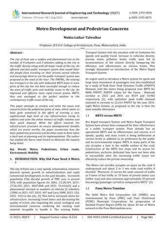
As per the Final Detailed project Report for the Pune Metro rail Project for Pune Municipal Corporation prepared by the Delhi Metro Rail Corporation Ltd (updated in Nov 2015), Route alignment of Pune Metro along 2 corridors viz: corridor 1- Pimpri Chinchwad to Swargate which is about 16.589 km and which is partly underground(for5kms)andpartlyelevated withatotal of15numberofstationsandCorridor2–Vanaz(Kothrud) toRamwadi whichis14.665 kmandcompletelyelevated with 16 number of stations. [1] The stations have been locatedsoastoservemajorpassengerdestinationsandto enable convenient integration with other modes of transport. Inter station distances are also uniform with theaveragespacingofstationsnotmorethanonekm.
The elevated Metro route has been planned to run on the roadataheightofabout10m.Withflyover-likestructure on piers at the road median which has reduced the carriageway widths by almost about @ 3 m all along this important arterial road. The Metro stations constructed arealmost35mwideand@140mlong.
1.4 Why elevated?
Various factors have mattered in the decision of proposing and implementing the elevated sections with costing,rankingfirst.BasedonDMRC’sexperienceinDelhi metro, constructing an elevated section costs 110 crore
while an equally long underground section would have cost them 275 crores. Technical feasibility is the second mostimportantconcernwithmakingachoicebetweenan elevated and underground metro rail corridor. Wherever possible, metro rail planners always prefer the elevated corridortotheundergroundmetrocorridorbecauseofthe engineering complexities and associated risks of cost and time overruns as well as the operating costs of Metro rail when they are in operational phase Security aspect also plays a major role with Metro rails throughout the world (alwayshighonthehitlistofterrorists).Anyattackinthe underground portion leading to derailment or collision is likely to cause five times more damage than an elevated one (Sreedharan 2008). Problems in acquiring land/properties along the proposed corridors and their socio-economic impacts due to resettlement and rehabilitation related issues pose a major obstacle to the elevated metro line, however in case of Pune Metro corridors, comparatively very few acquisition matters were required to be handled due to the Road mass that wasbasicallybeingoccupiedbythecorridorlayout.
2. ANALYSING THE PRESENT SCENARIO
Thepresentstudyisbasedontheon-fieldobservationsof the part of Corridor 2 which starts from Vanaz (on Paud road near Chandani Chowk) to Deccan (which is a major junctionandstart ofKarve road)thuscoveringa distance of @4.6 kms starting with the dead end depot area and coveringconsecutive5/6stationlocationlengths.
© 2023, IRJET | Impact Factor value: 8.226 | ISO 9001:2008 Certified Journal | Page 942
Fig 1: PuneMetrocorridorsProposed(ref: vrdigitallife.blogspot.comretrievedon27/08/23)[4]
International Research Journal of Engineering and Technology (IRJET) e-ISSN:2395-0056
Issue:
| Aug 2023 www.irjet.net p-ISSN:2395-0072
Volume: 10
08
International Research Journal of Engineering and Technology (IRJET) e-ISSN:2395-0056
Volume: 10 Issue: 08 | Aug 2023 www.irjet.net
ConstructionoftheMetrolineshaveresultedinsubtlebut multiplechangesintheroadareasbelowlikechangingthe spatiality of roads below and changed volumes for the pedestrians’ usage and movements, changed patterns of road usage for road users etc. The present study by the author attempts to observe and enlist the changed scenariosfortheroaduserandtheregularpedestrian.Itis observed that Pedestrian conveniences have been overlooked in many aspects. Any urban level infrastructureplanning,withallitssophistications,should aim for Pedestrian facilities and convenience, first in any urbandevelopment.
p-ISSN:2395-0072
Raised metro has completely changed the volumetrics of the road section, completely transforming the sectional dynamics of the existing Urban Arterial Road. Elevated corridors have adversely affected the imageability of the city, blocking and dividing the urban volumes of significance. The raised metro constructions have metamorphosed the existing urban images and foregrounds of important landmark buildings thus changingtheimages.Importantly“increaseconcretization of the whole city which might lead to irreversible microclimatic changes including increased heat-island effects.” Raised metro in this corridor thus completely occupies and swirls along the road curvatures, at times completely shadowing the entire road widths, barely leaving an air bufferforthesidebuildings.
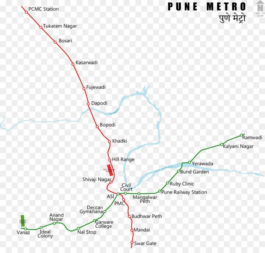
The stretch of Karve Road towards the Deccan area has a number of educational institutes and also health care facilities. A similar situation also prevails near Nal stop. With many school and college students approaching the area in both directions, crossing the road with a high speed - high density traffic has always been a challenge. The construction of the elevated corridor has required a divider width all along the road, hosting the support columns to the corridor or stations above. Crossing bays have been produced in the divider widths for the pedestrians. However, they are at certain points only, alongthe roadlengths leadingtoconcentratedpedestrian crossings at some points. Very Few breaks in the divider lanes make it difficult for seniors and kids to cross the roads requiring more lengths to be covered. Absence of any underpass for safe crossing makes the task more challenging.


© 2023, IRJET | Impact Factor value: 8.226 | ISO 9001:2008 Certified Journal | Page 943
Fig 2: ThestretchofCorridor2understudy.TheRed rectangleindicatestheVanazdepotwiththestars indicatingtheMetrostationlocationsalongPaudroad (blueline)andKarveroad(yellowline). BaseImage: GoogleEarth.
Fig 3: Thecontinuousmedianswithreliefbreaksfor crossoversforpedestrianstoaccessresidentialareason eithersideoftheroads.
Fig 4: TheColumnintheKinaraHotelJunctioncompletely changingtherotarygeometry.
International Research Journal of Engineering and Technology (IRJET) e-ISSN:2395-0056
Volume: 10 Issue: 08 | Aug 2023 www.irjet.net
Manyeateriesonthenorthernedgeoftheroadareregular visit spots for college students across the road. The Continuous divider deters the students from crossing, greatly affecting the business of the eateries. Stretches of Paud Road which are one way only have also got divided with the metro corridor columns, thus reducing the effective road widths and alienating the two edges of the road.
Sight and perception of the other side of the road, to a great extent, has been lost, completely dividing the vast sectional expanse into two tunnel-like volumetrics on eitherside.Thisisfeltmorebelowthestationareasandits immediate surroundings. Parking lanes that once existed have been lost due to road widths consumed by the divider widths and footpath widths have been lost to the infrastructural facilities of access and approach for the stations,effectivelyreducingthepedestrianwidthsonthe roads. This is a situation where more and more pedestriansareexpectedtogatherwhichmaysoonleadto disturbances on the traffic moving on the roads below. Very less side open spaces have been a matter of urban limitationfortheplanningofpedestrianpublictracks.
p-ISSN:2395-0072


residential areas on both sides of the road. This has thus led to a major Bus stop cancellation at a major interchange, creating inconvenience to the pedestrians whowouldapproachtheareasperpendiculartothemetro line, from law college road and Mehendale garage areas, thusleadingtoincreasedwalkingdistances.Highnumbers ofpedestriansaccessingthemetrocannotdependonlyon widths and surface finishes of footpaths if lengths are not shortenedandeasytoaccessandtravel.
AsimilarsituationalsoresultedattheSNDTjunction.The deletion of the bus stop created a major chaos as the students approaching and leaving the SNDT institute and schoolsalongthe Lawcollege road, (which is a very large number)hadtowalkquiteadistance.Thesituation,inan attempt to rectify has further given rise to a situation leading to major traffic chaos at the junction. A bus bay specially for a bus stop has been designed along with the pedestrianstaircasetocrosstheroad.However,thePublic transport bus, first cuts all lanes on its left to halt at the bus stop and secondly, while proceeding to Paud road (Almost 50 % buses proceed in this direction) again cuts all lanes to the right to take the flyover to the Paud road. This halts all traffic coming from behind and is a major problemduringpeakhours.
The layout of the metro corridor along with the flyover being constructed also changed the existing public transport provisions along the road. The PMPML (local bus transport) bus stop halt at Nal stop got deleted for wantofspacealongtheroadedgeatitsspot.Nalstop bus halt was at a major intersection of 4 major roads leading to 4 main areas of the city, also giving access to the

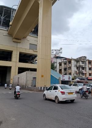
The ecological and environmental impacts are easily seen withmanystuntedtreesstandingontheroadboundaries. The Width and the projection of the Metro stations required the cutting of trees at many locations along the roadthusrenderingmostofthemetro-stationareas,along the road, without greenery. Loss of trees along the road edgesandplantationsalongthemedianshaveaffectedthe aesthetics of the place and would certainly have an immediate impact on the micro-climate of the space. This is being attempted, as observed, to be compensated with

© 2023, IRJET | Impact Factor value: 8.226 | ISO 9001:2008 Certified Journal | Page 944
Fig 5: TheNalStopareawiththeredtriangleindicating thebustopwhichnolongerexistattheintersectionof2 majorroadsand2residentialareasoneitheredges.
Fig 6: TheVerticalgreeneryonthepiersatStationends.
Fig 7: TheGanapatitableauxduringVisarjanprocession KarveRoad.
theverticalgardensbeingdevelopedalongthecolumnsat certain spots. This negative impact on the loss of vegetation due to project location was identified in the detailed report which also mentions that “The proposed metro lines are in urban/ city areas and will not pass through any forests. However, due to the proposed metro constructionabout685maturetreesarelikelytobelost.” The same report mentions 246 trees on corridor 1 and 765 trees on corridor 2 to be affected as above ground services, which are “also required to be shifted and relocated suitably during construction of the elevated viaduct”.[2]
The Provisionsoflifts and staircases blocksand elevators to access the metro station, have been built along the footpath widths and have effectively rendered the road edges without any other activity presently rendering the stretches dead in the evenings and night times. A very busy and bustling road exhibits intermittent patches, specially below the stations, to be very empty and hence with a sense of insecurity to the walkers along the road specially in very early or late hours, unlike the other vibrantlocalitiesalongthestretch.
Whetheritispartofsomeyettobedevelopeddesignora calculatedmistake,remainstobeseen,butacolumnatthe Kinara hotel junction has been located such that it has disturbedtheentiregeometryofthejunction.Thecolumn has got so placed that neither can it act as a rotary nor allow a lane to go beyond completely stressing the movementofvehiclescrossingovertogoperpendicularto the metro route. The Kinara junction, supporting the columns,isrightinthemiddleof the roadcreatinga very oddroadjunction.
The spatial layout of the corridor with the multileveled flyover at the Nal stop junction has also compelled to change the spaces traditionally known to host the Roadside festivals and the ephemeral celebrations during the Ganapati festival. Ganapati festival in Pune is a global festival with a very high fervor of celebrations and festivities. The Ephemeral pandals are erected at various spotsyearafteryear tocelebratethefestivities. Sincelast year,theGanapatiMandalhasbeenallottedaspaceunder the flyover, otherwise used for parking vehicles, after its traditional location has been rendered redundant for the festivityhosting.
Not just the change of location, but the planning of the metrocorridorbaseheightwasquiteacontroversyasthe clear height below the metro station did not take into consideration the height of the tableaux of the Ganapati festivalparadedduringthelastdayimmersionprocession, a point that certainly has not gone down well with the festival organisers of the city. As measured by the police, theheightofthemetrovariesfrom21ftatLakdibridgeto
18feetundergarwaremetrostationon KarveRoad to 17 feetunderthenewlyconstructedNalstopflyoverwiththe carriageway width near the flyover ramp not more than 15feet.ThepolicehadthereforeappealedtotheGanapati mandals to consider the same before preparing the tableauxforprocession.[5]

Many prime road facing/road edge spaces, with a very high commercial value, have been acquisitioned and consumedby thestaircases andskywalksbuilttoprovide access to the metro stations. The huge staircases hide many buildings behind them, completely blocking the facades and openings to those buildings. Also, in order to ensure the development of staircases within theavailable areas, the skywalk lengths have greatly increased making the pedestrian walk longer lengths to access the station entries. Attempts in planning for a quick and short entry formenandwomenonfootiscertainlynotobvious.
Thisisalsonotedonthestretchofthecorridorwherethe metro route crosses over to the river bed to avoid going along J M Road. However Long stretches of skywalks on J M Road, increasing the walking stretches for pedestrians, also adding a lot of infrastructure setup for accessing the metro stations from the main arterial roads. Concept of traffic planning and Integration though one of the objectives in proposed planning, have as yet not seem to have been effectively implemented. Facilities in conformity to suitable linkages are still to effectively contributeintheworkingofthemetroroutes.
Redevelopmentscenariosalong the roadside ofthe metro corridor, with additional FSI is likely to increase the population density of people and in turn the density of vehicles in the same stretch of the road, adding to the woes of thepedestrian.Metrostationsare certainlygoing toattractalotofpeoplehoweverduetolackofspaceand the congested surroundings; no dedicated parking spaces have been built. This is directly going to impact the
International Research Journal of Engineering and Technology (IRJET) e-ISSN:2395-0056 Volume: 10 Issue: 08 | Aug 2023 www.irjet.net p-ISSN:2395-0072 © 2023, IRJET | Impact Factor value: 8.226 | ISO 9001:2008 Certified Journal | Page 945
Fig 8: TheskywalkforpedestrianstoaccesstheMetro station.
movabilityandthemobilityofthepedestriansintheareas inthenearfuture.Thisissueneedstobeaddressedandbe takencareofonprioritywithmeticulousandeffective‘last mileconnectivitymeasures.’
The Main local public transport depot lies at Kothrud Depot which is barely a kilometer away from the Vanz depot and Chandani Chowk, a major intra city junction @1.5 kms. These areas with major transitional traffic are near enough to not get a Rick to approach the station but long enough to walk with luggage thus deterring the passengers to use the metro and still opt for personal vehiclesorautorickshawtotraveltocityparts.
CONCLUSION:
The Metro Rail project is a capital-Intensive project built inmostlydifficultanddenseurbanareaswithaveryhigh cost of planning and implementation. They are built in very dense urban settings to destress the urban roads of the regularly occurring chaos and streamlining the traffic quantity. They are big infrastructure projects and directly influence the social, physical, financial and environmental aspects and their impacts on a short as well as long run. The pedestrian perspective should always be at the forefrontinthedesignlayoutanddesignconsiderationsof the project. Utility and aesthetics should not be compromised and compensated upon at any stage of its construction. Existing public transport system should merge effortlesslyintothe workingoftheMetrolayoutto ensure a smooth transformation for the pedestrian comfort and use of all facilities. There are many advantagestohavingaMetroinanUrbancity,howeverit should at no stage in its design affect the pedestrian comfortandconvenienceintheuseofroad.
Note:
1. Stretch of Karve Road: Karve Road is a main arterial city road of Pune that connects the Deccan JunctiontoKothrudandWarjeareasandtravel furtherto getconnectedtotheMumbai-Banglorebypass.
2. StrechofPaudRoad:PaudRoadisamainarterial city road of Pune that begins just beyond the SNDT campus and bifurcates to go towards Paud areas beyond the Chandani chowk. The road connects Karve Road to Vanaz area and Bhusari colony and travels further to get connectedtotheMumbai-Bangalorebypass.
3. Reference statistics is for PMC areas only for this study as the road stretch being analyzed falls in PMC limits.
REFERENCES
[1] DMRC (2015) Final Detailed project Report for the Pune Metro rail Project for Pune Municipal Corporation prepared by the Delhi Metro Rail Corporation Ltd (updatedinNov2015)
[2] Sreedharan, E. (2008), ‘Underground Cost Won’t Let Metro Go Too Far’. Available online at http://articles.timesofindia.indiatimes.com, accessed on 29
[3] Pune Metro: Opening, Route Map, Stations & Updates [2023] (themetrorailguy.com) retrieved on 27th August 2023
[4] Pune Metro: What No One Is Talking About (vrdigitallife.blogspot.com)
[5] “Ganapati Procession get Metri height cap this year” NewspaperreportbyGiteshShelkeinTimesofIndiadated 29th August2022
ABOUT AUTHOR:
Mukta Latkar Talwalkar is a Professor with Bharati Vidyapeeth (Deemed tobe University) College Of Architecture, Pune. She has her Bachelors in Architecture with Masters in Planning, Environment Education and Indology. She Actively engages in Heritage and EnvironmentAwarenessasanEducatorandInterpreter.
International Research Journal of Engineering and Technology (IRJET) e-ISSN:2395-0056 Volume: 10 Issue: 08 | Aug 2023 www.irjet.net p-ISSN:2395-0072 © 2023, IRJET | Impact Factor value: 8.226 | ISO 9001:2008 Certified Journal | Page 946