Assessing the impact of urbanization on Catchment Dynamics: A Case Study of Narsinghgarh Town, Madhya Pradesh
Harshit Kotiya1 , Dr. Sanjay Jadon2 , Ar. Harshita Mishra31Student of Master’s in Urban Planning, Department of Architecture and Planning, Madhav Institute of Technology and Science, Gwalior, Madhya Pradesh, India
2Assosiate Professor, Department of Architecture and Planning, Madhav Institute of Technology and Science, Gwalior, Madhya Pradesh, India

3Assistant Professor, Department of Architecture and Planning, Madhav Institute of Technology and Science, Gwalior, Madhya Pradesh, India ***
Abstract - To meet the requirements of the growing population, there was urbanization and the associated changes in the water catchment areas of numerous gutters. Urbanization in watershed dynamics includes denudation through the junking of trees andfoliage, landuse changes due to the construction of structures, roads, and associated structures, and the diversion of face water runoff through sewers and reservoirs. constraint utmost of the impacts of these changes affects the hydrological systems of fairly small aqueducts, where the performing increase in flooding and river erosioncan be significant. Ingeneral, there's a reduction insoil infiltrationanderosion andanincreaseinsluicevolume and peak surface runoff. This study has an imperative base on the effects of quickly tending urban life and its impact on water resources in Narsinghgarh Town. The data for this paper comes from in-depth interviews with local dwellers, political employees, and King’s representative (Grandson) to break downhowaccelerating urbanlife is affecting the water catchment region. The finding indicates that the catchment region (Parasaram Lake) is virulently wormed by the local habitants, which results inflash floodingandanumberofviral conditions.
The encroachment within the town along the catchment region (Parasaram Lake) has caused deduction in the crosssectional areas andthe discharge carryingcapacityofthelake therefore causing flooding in the low-lying areas due to the water spilling over the catchment zones. At times there are some localities in the town that stay water-logged in spite of rainfall having stopped before 24 hours.
These spots are waterlogged because people holding encroached on the entire stormwater disposal system( Ponds and Lakes). A thorough study is carried out on the encroachments over the natural drainage system and its consequences by considering Narsinghgarh city as a study area.
Key Words: Urbanization, Catchment Area, Encroachment,Pollution,ParsaramLake,Narsinghgarh
1. INTRODUCTION
Urbanizationis a populationmovefrompastoral tourban areas and the patterns in which society adapts to the remaking,generallyresultinthephysicalgrowthofurban areas,Eventually,itleadstoahorizontalorverticalgrowth of urban areas. A Country is called to be urbanized when over 50 % of populants live in urban areas. Population density,area,andeconomicorganizationaresomefactors thatmaybeutilizedtodescribeanurbansetting(Grannis, 1998).
The effect of urbanization varies in various parts of the world.AccordingtotheUnitedNationsbytheendof2008, 50% of the world’s population would live in urban areas insteadofruralasestimated.
Itisanticipatedthatbytheendof2050,64.1%and85.9%of thedevelopinganddevelopedworldrespectively,willbean urbanized international (Tribune, 2008). The issue of Urbanization is not new; however, since the urbanization procedure is continuing; it is dynamic and multifaceted. Numerousstudieshaveexaminedtheconnectionbetween changing land use and improved water quality. Human activities such as fast urbanization, industrialization, and conversion of rural land have an impact on both of these elements.Unexpectedpopulationgrowthisrelatedtowater quality degradation and is causing a large increase in nutrientsandmicrobialloads(Ghoshetal.,2014;Krishnan et al., 2013; Maillard and Santos, 2008). Therefore, urban areas hold the possibility that produce ecological and environmentalimpactsatmultiplescales(Ghoshetal.,2014). Thesespecialecosystemsdeliverthesolutionstochallenges as well as challenges for sustainable development in a rapidly urbanizing world (Breuste and Qureshi, 2011; Grimmetal.,2008;HanjraandQureshi,2010).
UrbanizationinthecontextofanevolvingcountrylikeIndia refers to the rapid expansion in the proportion of the population residing in urban regions as equated to rural areas.It'sdrivenbyvariousfactors,embracingpopulation growth,rural-to-urbanmigration,and economic breaksin urban capitals. Urbanization is a complicated and
transformative procedure that has deep social, economic, andenvironmentalimplications.Thecontinueddegradation oftheenvironmentposesarisktopeople'shealth,theirway oflife,thesurvivalofspecies,andtheecosystematlargein anygivennation(Banister,1998;Chenetal.,2014).
In the case of India, urbanization presents both opportunitiesandchallenges:
1.1 Opportunities
i. EconomicGrowth
ii. InfrastructureDevelopment
iii. InnovationandTechnology
iv. CulturalExchange
1.2 Challenges
i. Lackofhousing
ii. InfrastructureStress
iii. UrbanizationandHighUnemploymentRates
iv. SocialDisparities
v. EnvironmentalDegradation
vi. HealthChallenges
The population viscosity, profitable expansion, and employment possibilities in metropolitan areas make urbanization particularly prominent in India. The government is enforcing programs to ameliorate civic structure, give affordable casing, ameliorate public conveyance, and encourage sustainable development in troubletoalleviatethegoodsofurbanization.Tomakesure that urbanization benefits India's growth, ways are being made similar to smart megacity investments, slum recuperation,andeffectivecivicplanning.
At the present time, one of the biggest environmental hazards of any developed nation is encroachment on catchment areas, inadequate supply of clean water, the artificial method of cultivation, and rapid expansion in population, also Encroachment on catchment regions is a seriousenvironmentalissuethatcanhaveprofoundeffects forecosystems,watersupplies,andpopulations.Catchment areas,referredtoaswatershedsordrainagebasins,areland regionswherewaterflowsintoasharedbodyofwatersuch asariver,lake,orpond.Incatchmentregions,encroachment refers to the illegal possession, building, or usage of land withintheseimportantzones.
2. REVIEW OF LITERATURE
Thematurityofurbanizationoccursnotjust indeveloped countries, but also in coming ones. Although it's driving manpower for conversion, financial, and industrial
progression, there's a growing establishment about its impactontheterrain.
Urban flash floods are an alarming danger to Asia's and Africa's expanding cities. A large share of the low-income populationlivesinlocationspronetorecurringandlocalized floods.Flooddisastersdisproportionatelyaffecturbanslum inhabitants with few resources. Accelerated flood tide frequencyinurbanareasisoneofthemostburningissues for policymakers and officers from public, domestic, and municipal authorities. Although scientific studies demonstrate that massive rainfall circumstances in urban regionsareaccelerating,theyaren'tthemaincauseofurban floods. Changes in watershed hydrology as a result of unregulated concrete space expansion, encroachment on natural drainage routes, trembling of wetlands, and other factorsresultinsignificantfloodingrisk.
Guptaetaldiscoverednosignificantrisingornegativetrend inrainfallduringtheprevious200years,andevenadropin thelast20years,despitearecordofgrowingfloods.Landuseconcernssuchasreducednaturalspaces,lossofwater bodies, encroachment of rivers, streams, and drainage systems, and unregulated building activity have all been recognizedascontributingfactorstoChennai'sfloodrisk.
Apart from the city's rapid population growth, increased built-uparea,increasedrainfall,andshrinkingwaterbodies, Ramachandra et al. pointed out that the local governance bodylacksadequatepowerstoplan,decide,andadminister the city. The State has established several parastatal organizations,eachofwhichoperatesinitsowngeographic region,complicatingthecoordinationofvarioustasks.
JODHPUR:Everymonsoon,thecityregionsbecomeislands due to persistent government apathy towards the city's drainageinfrastructureandtherefusalofmunicipalentities to hasten work to connect six major nullahs (drainage outlets)totheJojariRiver.
Duringhistenureasmayorfrom2009to2014,Rameshwar Dadhich drew out a master plan for the city's drainage system, but it has been accumulating dust for nearly a decade. He'd also planned other paths for the nullahs. AccordingtoTarachandGosai,formercommissionerofthe previous Jodhpur Municipal Corporation, the city would continue to flood during the monsoon unless this master planisimplemented.Foralongtime,theRajasthanUrban InfrastructureDevelopment Project(RUIDP)hastakenup thedevelopmentoftwoofthesenullahs(BhairavandMata kaThan),butlackofmoneyhasheldtheworkonholdfor more than three years. MLA Panwar stated that work on these nullahs would begin soon because the state government just approved Rs340 crores for the city's sewage system, and the remaining work on these nullahs willbefinishedunderthisgrant.
Anotherhazardtothedrainagesystemispoorengineering andalackofmoxie.executiveauthoritiesfrequentlytravel theroadwayswithofficersandexternalbodies,butindeed these visits haven't supported the megacity in chancing feasibleresults
Thecurrentstudyexaminestheimpactofslumsandother encroachmentsonNarsinghgarh’saqueductsandnear-water bodies on flash flooding by assaying two significant flood tideoccurrencesduringtheformerdecades.
3. INFORMATION AND PROCEDURE
Narsinghgarhtownissituatedat23.7degreeseastlatitude near the northern border of Madhya Pradesh. Its average heightabovesealevelis483m.(1584feet)anditisabout85 km north of Bhopal. It is situated far away. Narsinghgarh situatedinthemiddleofforestsandmountainsislikeacity situatedinthevalley.Locallyknownas"ChhotaKashmir", thistownhasimmensetourismpotential.Thenaturalbeauty ofthiscityisatitspeakintherainyseason.
Thecityisalmost300yearsoldandwasfoundedin1681by Dewan Parasram. The beautiful lake of the city, which mirrorstheoldfortressandpalace,stillbearsthenameof thefounder.Thecityis83kmawayfromBhopal.
Thetownisalsodottedwithnumeroussuitablelakes,which formpartofthecatchmentofNaturalwaterflow.
Theoverallgroundlevelofthetownvariesfrom8mto12m bgl.Ithasanaverageperiodicrainfallof985.8mmMonsoon isspreadoverthemonthofJunetoNovember.Duringthe monsoonseason,around92oftheyearlyrainfallisattained.
During the reign of Dewan Parasram (1681), there was overalldevelopment,andduetohisbettervision,heplanned a better and acceptable system of stormwater operation, which included a storm sewer in the walled town and a systemofconnectedlakesandpondstotheinfluentknown asParvatistreamforstormwaterdischarge.
With the passage of time, the city has grown haphazardly duetounplanneddevelopment,populationshiftsfromthe hill to neighboring catchment areas, and a rapid surge in urbanizationafter1975-76,alongwithalackofappropriate planningandadministration.Peoplehaveencroachedonthe natural system of Parsaram lakes due to a lack of appropriate vision for a stormwater disposal system. Residentialcommunitieshavebeenbuiltinthefloodplainof Parsaram Lake and on natural hill ridges. Filling the floodplainandponds/lakesresultsintheformationofslums.

The development of industries in Narsinghgarh led to the influx of unskilled job seekers and daily wagers besides a skilledandeducatedworkforce.Theformerhasledtothe growthofslumswherepoorworking-classpeoplelive.
4. WATER STREAMS
The Parvati River enters the western region of Rajgarh districtfromthenorthernslopeoftheVindhyachalrangein Sehoredistrict.Initially,itflowstowardsthenortheastbut nearBiaoraitturnstowardsthenorth.Bythetimeitreaches Narsinghgarh, its size becomes remarkably large, at some placesthedistancebetweenitsbanksis3km.Tillthen.

The Parasram Sagar PondinNarsinghgarhissurrounded byhillsonthreesides,oneofwhichhasafortonShiva,the otherontheMahadevtemple,andthethirdontheHanuman temple. They were built in 1690 AD by Shri Dewan Parasram,thefirstkingofNarsinghgarhstate.
OverinflowoftheParsaramreservoirduetohighrainfallin thecatchmentarea,highwaterlevelofParwatistreamdue todischargefromthereservoir,highintensenessrainfallin thetownarea,highrunoffgenerationduetoimpermeable surfaces,andlackofdiscardingsystemduetoencroachment onnaturalrainspoutsandpondsarethemajorreasonsfor floodtideinNarsinghgarhTown.explorationsshowthatthe major climate revision is indicated in the town with the drasticchangeinrainfallpatternafter1970.
5. DATA COLLECTION
i. Narsinghgarh Municipal Corporation provided water level data during flood occurrences at Parsaramreservoir.
ii. Basedonreal-siteinspection,satellitepictures fromGoogleEarthareprocessedtodepictthe encroachmentonthewaterway.
iii. News18obtainedsomephotographsoftheactual floodscenario,whileotherswereobtainedviathe socialmediasitewww.facebook.com
iv. Narsinghgarhrainfalldatafrom1961to2014was obtainedfromtheWaterResourceDepartment (MPWRD).
6. ANALYSIS
The Google Earth program is being used to analyze encroachment on the floodplains of the Parsaram lake, naturaldrains,andlakesinNarsinghgarhtown.Fieldvisits wereusedforgroundtruthing.Floodwaterlevels,visits,and interviewswithinhabitantsatflood-inundatedplaceswere usedtoassesstheimpactofencroachmentontwosignificant floodoccurrencesofthetwenty-firstcentury.
7. RESEARCH DESIGN
The current academic inquiry worked with a qualitative researchdesign.Inthiscase,aninterviewschedulehasbeen usedasadata-collectingtechnique.Tenin-depthinterviews were done in each of the two settlements. The inclusion criteriawerefocusedonlocalmembers,particularlythose livingalongthebanksofParsaramLakeandthecoremarket where flood occurs casually, and members of Local Government,andpoliticalworkers.
8. OBSERVATION AND DECODING
Thecommunitymemberswereinterviewedintheirnative language, translated into English, and analyzed multiple times to avoid misinterpretation. The researchers establishedthemesandsub-topicsaftermultiplediscussions overinterviewcodesandcontents,validatingrespondents' overtandcovertnotions.
9. EXISTING WITHDRAWAL SYSTEM
Duetothecity'sabsenceofawater-sewageinfrastructure, uncleanwaterisnowrunningoverthenaturalslopeofthe soil. The unclean water eventually combines with the rainwater. Flows into drains or accumulates in low-lying places.Itisobviousthatthisconditionishazardoustoone's lifeandhealth.MostresidencesinNarsinghgarhhaveprivate septic tanks, but there is no system in place to separate unclean water from rainwater. Each house's filthy water flowsintoalargedrainvialittledrainsbuiltonthesideof theroad.Theoverallamountoffilthywater/rainwaterinthe cityhasnotbeendetermined,norhasthecompletelengthof thedrains.Thepollutedwaterfromtheentirecityisbeing drainedintothecity'smaindrain.Drainsfillwithwaterin
theirlowestsections,andstagnantwatercancausemajor healthconcernsintheregion.
10. EXISTING SEWERAGE SYSTEM
The treatment of contaminated water is required for environmentalandhealthreasons.Alongwiththeunclean water from residences, the dirty water from industry and companiesmustbetreated.
Narsinghgarh's waste management situation is appalling. Thereisnosubterraneanwater-sewagesysteminthisarea. As a result of these conditions, unclean water enters the riverviaopendrainsandcausespollution.
10.1 The Possibility Factor
Thesituationofsubmergenceandflooding.
Ignoringnaturaldrainageinunplanneddevelopment leadstosubmergenceandfloodingduringtherainy season.
In the city, water drainage through drains is poorly organized. Water logging is a typical problem in marginal regions due to the absence of a drainage infrastructure.
Because the drains' water carrying capacity has decreasedduetosiltation,wateronlyflowsoutduring thepeakoftheflow.Theissueworsensduringthewet season.
11. DEMAND GAP ANALYSIS
Thereiscurrentlynoundergroundseweragesystem,thusall uncleanwaterisreleasedintosewersanddrains.Asaresult, Table 2 provides estimates of the needed length of a sewerage system. According to the CPHEE handbook, the lengthofthesewagesystemisabout80%ofthelengthofthe roadways,onwhichtheestimatesarebased.
12. SWOT ANALYSIS OF THE STUDY AREA
A SWOT analysis is a strategic planning technique that is used to evaluate the internal and external elements that mightimpactinthisexample,afloodzoneregion.
This study aids in identifying the area's advantages, problems, prospective growth avenues, and external dangers.
Strength
Naturaldrainageavailability
Weakn ess Opendrainsaresometimesusedforsewerage. Separatearrangementsmustbemadeforthe disposalofrainwaterandsewage.
During the rainy season, a flood scenario is formed in the shallow regions due to nonmaintenance of drains, invasive plants, and congestion. As a result, health issues and unsanitarycircumstancesoccur.
Solid waste is being dumped into sewers, which is completely unacceptable. Drain embankmentsacrossthecityareinastateof ruin.
Opensewersarecarryingsewage.
Thedrainsarefullinmanyareas,obstructed, damaged, or the flow of water exceeds their capacityowingtoovercrowding.
Opport unities
A well-designed and well-executed plan is requiredforsewageandrainwaterdrainage.
Highpopulationdensitycanbeusedowingto minimalcapitalinvestment.
Public toilets are required to avoid open defecation.
Threats
Water-sewage growth in drains complicates health issues. Unplanned construction has hinderedthecity'snaturaldrainagecanals.

Unorganizeddevelopmentisnotcontrolledin shallowareasandnaturaldrainagechannels whiledevelopmentcontroliseffective.
Theburdenonwaterandsewagewillincrease moreasthepopulationgrows.
Poorsanitationinnewsettlementsendangers people'slives.
13. RESULTS AND DISCUSSION
Respondents from the community believe that the city's populationisfastincreasing,whichisproducinga slew of problems,particularlywithregardtowatershortagesand pollution.Theseareregardedashighlysignificanthazardsto thelocalcommunityandallcityresidents.
14. FLOOD PLAINS AND AFFECTED WATERWAYS
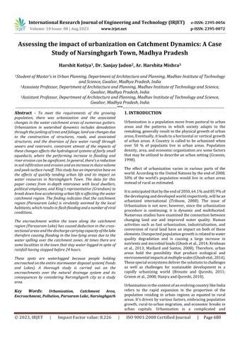
Changes in land use in catchment flood plains and floodinundatedregionsinthecityarecalculatedbycomparingthe earliestaccessibleGoogleEarthpicture(December2008)to the most current (April 2023). High-end bungalows and residentialcoloniesneartheParsaramLake(Fig.4)Another commercialmarket(Fig.4)upstreamofthePalRoadBridge is having the same problem. A relatively new building is being built near Chota Talab (Fig.5) on the ground that previously served as an inundation pond during major floods.Thisworkappearstobeaffectingtheoutfallofthe ChotaTalabroadrivuletaswell.Theinstallationofafood market(Fig.Oneoftheoldestdenseslumslocatednearthe catchment area is Thawariya Mohalla (Fig. ). This slum is impactedwhenthelakefloods.Theslumdownstreamofthe Parsaram Lake (Fig.6) has grown into the space that was formerly used as an inundation pond. The Parasaram and chotatalablakebanksslumisevacuatedunderthisstrategy. Thefiguredepictstheevacuationofaslumonbothbanksof the lake near the Narsinghgarh town. The graphic clearly showsconstructiononalakefloodplain.Floodingintheeast andwestsectionsofNarsinghgarhiscausednotjustbylocal rainfall but also by overflow from outside the city limits.
Though slums have not been removed from the banks of Parsaram Lake (Fig6), and Chota Talab (Fig7), concrete construction has developed on the watercourse's floodplains.SlumencroachmentwasfoundintheThawaria andBaradariwetlands(Fig6A).


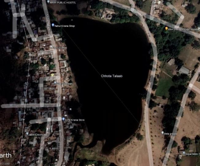


These wetlands were exploited for flood inundation and contributedtothearea'svulnerability.Thisisduetothefact thaturbanizationhashadanimpactonnaturalslopesand drainagesystemsnearChotaMahadevtemplehasdriedup, anddevelopmenthasbegunafterthelake'sareahasbeen filled. The lake adjacent to the Mela ground has likewise driedup,andaroadhasbeenbuiltfollowinglandfilling(Fig. Site investigations are used to validate the validity of satellite photographs of flood-prone areas against actual circumstances.Drainageblockagesweremostprevalentin the Parsram Lake drainage and its catchment region in ThawariyaandBaradwari.Manyminornaturaldrainswere destroyedinthisregionbyillegallandfillsandaccretionon bothsidesofthecatchmentarea.
15. FLOOD IN NARSINGHGARH


Todemonstratevariancethroughoutthemonthsratherthan justthemonthlytotals,hereistherainfallgatheredovera sliding 31-day period centered on each day of the year. Monthly rainfall in Narsinghgarh varies drastically by season.
From May 14 to November 4, the rainy season lasts 5.7 months,withatypical31-dayrainfallofatleast0.5inches. August is the wettest month in Narsinghgarh, with an averagerainfallof11.9inches.
Theyear'srainlessseasonlasts6.3months,fromNovember 4toMay14.AprilhastheleastraininNarsinghgarh,withan averagerainfallof0.1inches.
16. AVERAGE RAINFALL DATA
RainfallfallsinNarsinghgarhfromJunetoSeptember,with an annual average of 923 mm. Due to upper air cyclonic circulation,this moderate rainarea in Rajgarh district got exceptionalrainfallofroughly1609mmfromJune24toJuly 4, 2006. The worst occurrence was the Dudhi River in
Narsinghgarh, where a roughly 100-foot-long breach emerged in the check dam-cum-reservoir (Kunwar Chain Sagar) when it overflowed and water spilled out towards communities downstream. Much of the excess water was drained into the Parwati River, which runs through the peripheryofNarsinghgarh.
17. CONCLUSION
Based on an analysis of Google Earth pictures, substitute localities were created skirting drainage ways and water disposal bodies throughout urban growth, performing in flashfloodtideoccurrencesinthemajorityofNarsinghgarh Town.Satelliteprintsrevealthecurrentstateofthetownof Narsinghgarh'swaterbodies.It'seasytoseethatthetown containsanumberoflakesonitsperipheryandtherewasa system of interconnecting lakes through streamlets that dissolvedduringconstruction.
Due to the lack of sewage infrastructure in Narsinghgarh, unclean water released from dwellings and business establishmentsnowrunsalongsiderainwater ontheopen surface.ThiswatereventuallyflowsintotheParvatiRiver viadrainsorfillsinlow-lyingareas.Inbothcircumstances,it is certain to have a negative impact on the health of the nearby inhabitants. It is obvious that the municipality of Narsinghgarh will have to prioritize the development of a sewerageplanfortheentirecity,sothatuncleanwaterand rainwater may be collected and transported to the right locationfortreatment,treatment,andreleasedintotheriver, orforotherpurposes.
Drains,pumpingfacilities,andtreatmentplantswillneedto bebuiltforpurposessuchasirrigationorcommunityusage. Along with this, arrangements will be made for the city's futuregrowth.
Seweragepipesaccountforabout80%oftheentirelengthof the water delivery system. On the basis of which 38 kilometerswerecoveredinthefirstphase.Pipeswillhaveto belaid,andthesecondphasewillcover19kilometers.
Beforebuilding,ariskstudyforhighfloodconditionsatsuch specificplacesshouldbeperformed.Spatialvulnerabilityto flooding should be assessed using temporal satellite data. Long-termlandandwaterresourceplanningshouldbedone by combining traditional approaches with high-resolution satellitedata,whichmaybeusefulincalculatingtheriskofa floodhazardanddisastermanagementtopreventdamage.
References
[1] A. Ibidun, "Vulnerability of poor urban coastal communitiestofloodinginLagos,Nigeria,"2010.
[2] A. M. Jahangir, "The organized encroachment of land developers-Effects on urban flood management in GreaterDhaka,Bangladesh,"SustainCities,2014.
[3] CRISIL,"InfrastructureAdvisory,CityDevelopmentPlan for Vadodara under JnNURM," Vadodra Municipal Corporation,2005.
[4] A. G. a. S. Nair, "Flood risk and context of land uses: Chennaicitycase,"RegionalPlan,2010.
[5] M.S.M.a.M.H.IshtiaqueAsif,"EncroachmentofCanals ofDhakaCity,Bangladesh,An," Geoscape,, vol.8,pp.4864,2014.
[6] A.K.Lavanya,"Urbanfloodmanagement acasestudy ofChennaiCity," Arch. Res, vol.2,pp.115-121,2012.
[7] O.Y.O.a.R.Tateishi,"Urbanfloodvulnerabilityandrisk mappingusingintegratedmulti-parametricAHPandGIS: methodological overview and case study assessment," water,2014.
[8] R. a. P. P. Mujumdar, "Urban floods: Case study of Bangalore, Disaster and Development," Journal of the National Institute of Disaster Management, Vols.Special Issue:UrbanFloods-II,pp.1-98,2009.