Investigating the Causes of Erosion in Kaltungo Local Government Area, Gombe State, Nigeria
Samuel Osusha Loya1* , Buba Wali2Abstract – This research investigated the causes of erosion and measures to be taken to prevent/control erosion in kaltungo Local Government area of Gombe State, Nigeria.The study employed the administration of a questionnaire to obtain relevant data. Relevant literature on erosion was reviewed to retrieve the causes of erosion and its preventive measures. Based on the review, 8 factors responsible for erosion were selected, and 9 measures to control and prevent erosion were selected. 200 persons were sampled with 20 representing each erosion site studied. A totalof187outofthe 200 administered questionnaires were retrieved and data obtained were analyzed using tables and figures. It was discovered that running water, deforestation,andgrazingare the major causes of erosion in Kaltungo Local Government Area with mean item scores of 4.6, 3.68, and 3.34 respectively. Devaluation of assets, depletion of land, poor topography, destruction of houses, desertification, water pollution, and land degradation are the major effects of erosion in the area; while construction of drainages, afforestation, and grazing control are the most important erosion control/prevention measures needed with mean item scores of4.58,4.31,and3.73 respectively. It was recommended that drainages should be constructed by relevant authoritiesatstrategiclocations.Also, cutting down trees should be highly discouraged and punishment meted on perpetrators while significant steps should be taken in reforestation. Grazing should be properly managed through the provision of grazing reserves.
Key Words: Causes,Erosion,Investigation,Kaltungo
1. INTRODUCTION
A desktop review of extant literature by the researchers reveals that erosion is a phenomenon enhanced by both naturalfactorsandhumanactivitiesandwhichoccursinall landscapes and under different land uses (Onwuka, 2008; Ibimilua and Ibimilua, 2011). As a host of animate and inanimatebeings,thesoilisthemostvitalnaturalresource onearth(Okin,2002).Unfortunately,over65percentofthe soil on earth is said to have displayed degradation phenomena as a result of erosion. Erosion according to Onuoha et al (2014) is the physical movement of soil particlesfromonelocationtoanotherprimarilycausedby waterforcesorwind.Hefurtherstatedthemostcommon types of erosion include sheet, rill, and gully erosion. AccordingtoQuinton(2014),erosionisagloballysignificant environmentalprocessthatdegradesthesoiluponwhichwe
rely for food production, clean water, and substrates for buildingandinfrastructure.Inagreement,Jeje(2005),and Adegboyega (2006) opined that erosion destroys infrastructures such as highways, roads, and buildings. Accordingto Ananda andHerath,2003,soilerosionisthe mostthreateningenvironmentaldegradationprobleminthe developingworld.TheBeijingTimes(2002)alsoidentified erosion as the direct cause of degradation and poverty, threateningthesustainabilityofplantsandanimalsinmany parts of the world. An unprecedented increase in soil loss and its economic and environmental impact have made erosiononeoftheleadingglobalenvironmentalproblems (Zhangetal.,2009).

Nigeriaisundoubtedlyfacingmanyenvironmentalproblems requiringurgentattentionwitherosionbeingoneofthem. ThiswasconfirmedbyWorldBankin2009whentheylisted erosionasoneofthetop5hazardsthreateningtheNigerian environment(Mbaya,2013).Withoutadoubt,erosionisa subset of environmental degradation in North Eastern NigeriawhereGombeStateislocated.AccordingtoMallam (2016), erosion is one of the greatest environmental disastersinthenorthernpartofNigeriawhichhasaffected hundredsofpeopleeveryyear.Thisisbecausethesoilsin North-EasternNigeriaarenaturallypronetoerosiondueto their fragile nature (Oguike and Mbagwu, 2009). Mbaya (2013)arguedthaterosionisactiveandatanalarmingrate aroundGombeStateduetosoilstructureandtexture,slope, rainfall, and human activities such as deforestation, overgrazing, excessive cultivation, and bush burning. He further stated that residents of Gombe have expressed concerns about the accelerated erosion rate, which has caused the loss of personal properties but also caused damagestoinfrastructuresuchasCulvertsandroadsaswell aspublicandprivatebuildings.
Naturalcausesoferosionincludedrainfall,soiltextureand structure,andslope,whilehumancausesoferosioninclude deforestation,excessivecultivation,overgrazing,andbush burning (Mbaya, 2013). Other causes of erosion are construction works, sand, and stone quarrying (Ubuoh, 2013), the nature of soil and topography (George et al., 2008),natureoftopography(Igweetal.,1999),excavations andmining,andclimate(Igbokweetal.,2008).Igbokweetal (2008)statethatsettlementpatternscanalsocauseerosion. Favorableconditioniscreatedforerosionwhensettlement isnotplanned,andhousesarebuiltindiscriminatelywithout
consideration of natural flood paths. When infrastructure such as roads is built without a proper environmental assessment.ThedangersposedbyerosionaccordingtoIgwe (2005) include loss of land for agricultureand habitation. Effectsoferosionalsoincludethedestructionofproperties such as houses, infrastructure, and utilities, a threat to vegetation,lossoflives,lossofsoilnutrients,depositionof debris,landdegradation,poortopography,andisolationof settlements(DanladiandRay,2014;Abdulfataietal.,2014; Anejionuetal.,2013)
Dependingontheprevailingtypeoferosion,manycontrol measuresmustbeadopted.Theseincludegrazingcontrol, control of tree felling, soil cover, and repair of existing erosionsites.Okoroaforetal(2017).Valentineetal(2005) foundthatmanytechniqueshaveprovedtobeeffectivefor erosionpreventionandcontrol,includingzeroorreduced tillage, vegetation cover, stone pitching, stone bunds, terracing,andcheck dams. Obiadi etal (2011)andOkorie (1997)advocatedforeffectivereforestation/afforestationof gully erosion-prone areas by planting trees such as pine caribaea,gemelinaorarboea,food/fruittreeslikeIrviniga spp,freculinaAfricana,andshrubslikeDactyladeniabartieri andAlchorneacordifolia.

Despite the identification of erosion by a plethora of previous research to be a major source of environmental disastersinNorthEasternNigeria,anddespitetheexistence ofprevailingerosioninGombeState,relativelyfewresearch havebeencarriedouttoinvestigateerosioninthestate,with no research so far on the causes and effects of erosion in KaltungoLocalGovernmentArea.Therefore,theaimofthe current study is to investigate the causes of erosion and measurestobetakentoprevent/controlerosioninKaltungo Local Government area of Gombe State, Nigeria. This researchiscarriedoutin2023.
2. MATERIAL AND METHOD
Relevantliteratureonerosionwasreviewedtoretrievethe causesoferosionanditspreventivemeasures.Basedonthe review,8factorsresponsibleforerosionwereselected,and 9 measures to control and prevent erosion were selected. 200 persons were sampled with 20 representing each erosion site studied. A total of 187 out of the 200 administered questionnaires were retrieved and data obtainedwereanalyzedusingtablesandfigures.
2.1 Questionnaire Design
Awell-structuredquestionnairewasdevelopedandusedto obtain information on the causes, effects, and control measures of erosion in the study area. The questionnaire comprised3sections;SectionAcontainsquestionsonthe respondent’s personal data such as age, sex, academic qualification,andhowlongtherespondenthasbeeninthe studyarea.SectionBcontainsquestionsonthecausesand effectsoferosioninthestudyarea,whilesectionCcontains
questions on the control measures to be adopted in managingerosioninthestudyarea.
2.2 Pilot Study
In verifying the appropriateness of the designed questionnaire in meeting the research objectives, a pilot studywascarriedout.Draftquestionnairesweresentto10 respondents,witheachrespondentrepresentingaWardin Kaltungo Local Government. The questionnaires were administered at this point to assess their content validity andtogiveconstructivecriticism.Uponretrievalofthe10 questionnaires,thedraftquestionnairewasmodifiedbased ontheirfeedback.
2.3 Data Presentation and Analysis
DatacollectedwerepresentedinChartsandTables,while Mean Item Score (MIS) was adopted in analyzing and rankingthedataoncausesoferosionandmeasuresrequired toprevent/controlerosion,whoseresponsesarebasedona 5-pointLikertscalerangingfrom1-5.Themodewasusedto analyzetheeffectsoferosionwithinthestudyarea.
2.4 Reliability Check
Statistical Package for Social Science (SPSS) was used to check the consistency of the data. According to Pallant (2007),areliabilitycoefficientof0.70andaboveisgenerally acceptable. In supporting this view, Oyedele et al (2003) opinedthatthealpha valueisexpectedtobegreaterthan 0.70 and that a higher alpha value equates to greater reliability.
Thedataforthisresearchisthereforefoundtobeconsistent asseeninthetablebelow
3. RESULTS AND DISCUSSION
3.1 Demographic Characteristics of the Respondents
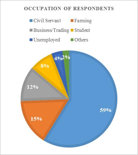
The analysis of the respondents’ occupations reveals that 59% are civil servants, 15% are farmers, 12% are businessmen/women/traders, 8% are students, 4% are
unemployed,and2%arefoundtobeinothercategoriesas seeninfig.3.1below.
Fig.3 presents respondents’ highest educational qualificationwith58%ofthemhavingBSc/BTech/HND,6% are MSc holders, 4% are Ph.D. holders, while 32% are in othercategoriessuchasOND,O’Level,FSLC,andnon-formal education.


RESPONDENTS' HIGHEST QUALIFICATION

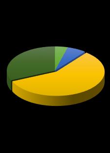
Fig.2belowshowsthat90respondentsareseniorstaffin theirplaceofwork,20arejuniorstaff,29arefarmowners, 22arebusinessowners,15areapprentices,7arelaborers, and4areinothercategories.


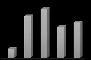
Fig.4indicatesthat55respondentsoutof187havespent between 11-15 years in their places of work/business, 40 havespent21yearsandabove,35havespentbetween1620 years, 47 have spent between 5-10 years, while 10 respondentshavespentlessthan5years.

3.2 Causes of Erosion in Kaltungo Local Government Area
Theoverallperceptionoftherespondentsonthecausesof erosion in their area is shown in Table 3.1. It can be observed from the Table that running water with a mean itemscoreof4.60isthehighestcauseoferosioninKaltungo LocalGovernmentArea,andisthereforeranked1st.Thiswas followed by deforestation witha meanitemscore of3.68, andthengrazingwithameanitemscoreof3.34.Thetable also shows that agriculture, construction, and mining activitiesarethelowestcausesoferosionintheareawith meanitemscoresof1.03and1.03respectively.
Table. 2. Showing causes of erosion in Kaltungo Local Government
MIS =MeanItemScore
Source: Researchers’Analysis(2023)
3.4 Effects
Table3belowshowstherespondents’opinionsregarding theeffectsoferosionintheirarea.Devaluationofassetsis theleadingeffectcausedbyerosionwith260appearances, followedbydepletionoflandandpoortopographywith200 and 110 appearances respectively. The 3 lowest effects identifiedbytherespondentsaredecomposeddebris,lossof lives,andairpollution,eachwith4appearances.
Source: Researchers’Analysis(2023)
3.3 Measures for Controlling/Preventing Erosion in Kaltungo Local Government Area
Table 2 shows the respondents’ perception of the measuresforcontrolling/preventingerosionintheirarea.In the respondents’ opinion, the top 3 measures are the provision of drainages, reforestation, and grazing control withmeanitemscoresof4.58,4.31,and3.73respectively. The lowest 3 measures as can be seen from the Table are mulching/plant cover, construction activities control, and miningcontrolwithmeanitemscoresof1.01,1.01,and1.04 respectively.
Table
Source: Researchers’Analysis(2023)
4. CONCLUSIONS
The extensive running water from hills, deforestation for urbanization, and overgrazing have led to the loss of

vegetation cover, reducing soil stability and increasing surfacerunoff.Theimpactofthesefactorsonerosionrates inKaltungoisconsistentwithfindingsby(Lopezetal.,2019; Olivares and López, 2019). The researchers, therefore, concludethatthefactorsmostresponsibleforerosioninthe areaarerunningwater,deforestation,andgrazing.
Thefollowingrecommendationsareproposedbasedonthe studyfindings:
Encourage reforestation initiatives to restore vegetationcoverandstabilizethesoil.
Cutting down trees should be highly discouraged andpunishmentmetedonperpetrators.
Implement erosion control measures such as drainage construction to minimize surface runoff anderosion.
Grazing should be properly managed through the provisionofgrazingreserves.
Byunderstandingtheunderlyingcausesandimplementing appropriate control measures, policymakers and practitioners can effectively manage erosion and promote sustainable land use practices in the area (Guevara et al. 2012).
ACKNOWLEDGMENTS
TheresearcherswishtoacknowledgetheTertiaryEducation TrustFund(TETFUND)forsponsoringthisresearchthrough theInstitutionalBasedResearch(IBR)scheme.

REFERENCES
[1] I.A. Abdulfatai,I.A.Okunlola,W.G. Akande,L.O.Momoh, and K.O. Ibrahim, “Review of gully erosion in Nigeria: causes, impacts, and possible solutions,” Journal of GeosciencesandGeomatics,Vol.2(3),2014,pp125-129.
[2] E.R. Adegboyega, “The Impact of Flooding and Soil ErosiononSocio-economicLivesin Ado-Ekiti,” an unpublishedM.ScThesis,submittedtotheDepartment ofGeographyand Planning Sciences, Faculty of the SocialSciences,UniversityofAdo-Ekiti,Ado-Ekiti.2006.
[3] J. Ananda and G. Herath, “Soil erosion in developing countries; a socio-economic appraisal.” Journal of Environmental Management, vol. 68(4), 2003, pp343353.
[4] O.C.D.Anejionu,P.C.Nwilo,andE.S.Ebinne,“Longterm assessment and mapping of erosion hotspots in southernNigeria.ApaperpresentedattheFIGWorking WeekonEnvironmentforSustainabilityAbuja,Nigeria, 6th-10th May,2013.
[5] Beijing Time (People’s daily). (2002). Soil erosion, biggestglobalenvironmentalproblem.Accessed28May 2002.
Available:http://English.peopledaily.com.cn.
[6] A.Danladi,andH.H.Ray,“Socio-economicseffectofgully erosiononlanduseinGombemetropolis,GombeState, Nigeria.”JournalofGeographyandRegionalPlanning, vol.7(5),2014,pp97-105.
[7] N.A.George,I. Obot,andN.Akpanetuk,“Geo-electrical investigationoferosionandfloodingusingthelithologic compositions of erosion and flood-stricken road in Ukanafun Local Government Area, Akwa Ibom State, Southern Nigeria”. Disaster Advancement, vol. 1(4), 2008,pp46-51.
[8] E.Guevara,B.Olivares,J.Demey,“Useofanddemandfor agrometeorologicalinformation in agricultural production systems, state of anzoátegui, Venezuela.” RevistaMulticiencias,vol.12(4),2012,pp372-381
https://n9.cl/yuyd
[9] A.F. Ibimilua, and F.O. Ibimilua, “Aspects and topical issues in human geography, Akure,” B.J Production Publisher,2011.
[10] J.I. Igbokwe, J.O. Akinyede, B.A. Dang, A.T. Alaga, V.C. Nnodu, and J.C. Ojiako, “Estimating soil loss in gully erosioninsoutheasternNigeriafromremotelysensed imageries.” Nigeria Journal of Space Research, vol. 5, 2008,pp135-151.
[11] C.A. Igwe, “Erodibility in relation to water-dispersible clayforsomesoilsofeastern Nigeria.”Landdegradation anddevelopment,vol.16,2005,pp87-96.
[12] C.A.Igwe,F.O.R.Akamigbo,andJ.S.C.Mbagwu,“Chemical and mineralogical properties of soils in southeastern Nigeriainrelationtoaggregatestability.”Geoderma,vol. 92,1999,pp111-123.
[13] L.K.Jeje,(2005).“Urbanisationandacceleratederosion: Example of Efon Alaaye, south western Nigeria.” Environmental Management Journal, vol. 2(1), 2005, pp1-174,vol.2,pp289-348.
[14] I.I.E. Mallam, “An assessment of gully erosion in Kano metropolis,Nigeria.”Global Advanced Research JournalofAgriculturalScience,2016,pp14-27.
[15] L.A. Mbaya, “A study of inter-relations among gully variables in Gombe town, Gombe State, Nigeria. Wudpecker J Geogr. Regional Plan., vol 1(1), 2013, pp001-006.
[16] B. López, B.M. Olivares, and D. Lobo-Luján, (2019). “Changes in land use and vegetation in the agrarian community Kashaama, Anzoátegui, Venezuela: 20012013.” Revista Geográfica De América Central, vol. 2(63),2019,pp269-291
https://doi.org/10.15359/rgac.63-2.10
[17] I.I. Obiadi, C.M. Nwosu, N.E. Ajaegwu, E.K. Anakwuba, N.E. Onuigbo, and E.O. Akpunonu, “Gully erosion in Anambra State, South East, Nigeria, issues and solutions.” International Journal of Environmental Science,vol.2(2),2011,pp795–805.
[18] P.C. Oguike, and J.S.C. Mbagwu, “Variations in some physicalpropertiesandorganicmattercontentofsoils of coastal plain sand under different land use types.” WorldJournalofAgriculturalSciences,vol. 5(1),2009, pp63-69.
[19] G.S. Okin, “Toward a unified view of biophysical land degradation processes in arid and semi-arid lands. In Global Desertification: Do Humans Cause Deserts?” EditedbyJ.F.ReynoldsandD.M.StaffordSmith.Dahlem UniversityPress,2002,pp95-97.
[20] O.O. Okorafor, C.O. Akinbile, and A.J. Adeyemo, “Soil erosion in southeastern Nigeria: A review.” Scientific ResearchJournal,vol.5(9),2017,pp30-37.
[21] P.E.Okorie,“Useofdacryodesedulisinerosioncontrol inagriculturallandsinNigeria,InKapanC,KayemGA (eds.):Proc.of2ndInternationalWorkshoponAfrican PoorImprovementandothernewsourcesofvegetable oil.”NgoendreCameroon.,1997,pp35–44.
[22] B.Olivares,M. López,“Normalizeddifferencevegetation index(NDVI)appliedtothe agricultural indigenous territory of Kashaama, Venezuela.” UNED Research Journal,vol11(2),2019,pp112-121
https://doi.org/10.22458/urj.v11i2.2299
[23] D.C. Onuoha, and S.U. Onwuka, “The place of soil geotechnical characteristics in road failure, a study of theOnitsha-Enuguexpressway,southeasternNigeria.” JournalofCivilandEnvironmentalResearch.IISTE,USA, vol.6(1),2014,pp55-67.
[24] S.U. Onwuka, “Urban erosion problems in Nigeria. Nnodu VC, Okoye CO, Onwuka SU (Eds), Urban EnvironmentalProblemsinNigeria.”2008,pp149–142.
[25] L.O. Oyedele, B.E. Jaiyeoba, and M. Fadeyi, “Design factors influencing quality of building projects in Nigeria: Consultants' perception.” The Australian Journal of Construction Economics and building, vol. 3(2),2003,pp25-32.
[26] J.Pallant,“SPSSsurvivalmanual:Astepbystepguideto data analysis using SPSS for Windows (3rd edition).” OpenUniversityPress,2007.
[27] J.N. Quinton, “Soil erosion modeling.” Encyclopedia of agrophysics,Springer,2014,pp746-747.
[28] E.A.Ubuoh,W.N.Akhionbare,E.Onweremadu,andO.A. Onifade,“Characterization of soil quality in erosion prone environment of Ukpor, Nnewi-South L.G.A of Anambra State, Nigeria.” International Journal of AdvancesinAppliedSciences,vol.2(1),2013,pp1-8.
[29] C.Valentin,J.Poesen,andY.Li,“Gullyerosion:Aglobal issue;impacts,factorsandcontrol.”CATENA,vol.63(2–3),2005,pp132–153.
[30] Y. Zhang, J. Degroote, C. Walter, and R. Sugurumaran, “IntegrationofModified Universal Soil Loss Equation(MUSLE)intoaGISFrameworktoAssessSoil Erosion Risks.” Land Degradation and Development,vol.20,2009,pp84-91.

