International Research Journal of Engineering and Technology (IRJET)


1 Student of Masters in Urban and Regional Planning, Parul Institute of Architecture and Research, Parul University, Vadodara, Gujarat
2Professor,Dept.of Masters in Urban and Regional Planning, Parul Institute of Architecture and Research, Parul University, Vadodara, Gujarat ***
Abstract - Rivers had always been the lifeline for any human settlement. One of the most challenging urban spaces that offers great opportunity for the development of the city is the waterfront. Communities near water bodies that are full of amenities are supported in adapting to their economic and social circumstances. Not just in terms of the riverfront context but also for the whole region. It brings together various aspects of place making, such as environmental responsibility, social equality, and economic viability, as well as planning and transportation laws, and architectural design, to create places with different character and aesthetic appeal. A successful riverfront with relevant socio-interactive spaces can be created using several case studies, which will be analyzed to give the strategies. The south-west and west zones of Surat city will be the focus of this research's study of contemporary riverfront projects. This planning proposal gives the plan of the development of recreational spaces, active zones, greens spaces and create safe, clean and healthy environment. The objective of this planning proposal would be to develop riverfront in Surat city and provide a socially interactive space with specific amenities for leisure and entertainment to the city.
Waterfrontsareimportantlocations.Theimportanceofthe waterfront is even increased when it is inside a city. A successfulwaterfrontdevelopmenthasapositiveeffecton boththequalityofurbanlifeandtheeconomyoftheregion. Overtime,waterfrontareashavebeenusedforavarietyof purposes. Many of them were used as docks and ports. However, as technology for transportationadvanced, they lost their usefulness and ceased to be active ports. Governmentscarriedoutriverfrontredevelopmentforthese areas in the 1970s and 1980s after the docklands were abandonedduringthosedecades.Therevitalizationofthe waterfront has created opportunities to convert unused docklands in the city into commercial space, homes, or publicopenspace.Theregenerationplanwilldrawpotential investorsandprovidecapital.
Trade and transportation played a role in the growth and declineofnumerouscities.Villageswithwaterfrontlocations developed into fishing communities and trading ports. During the Industrialization Era, a lot of industrial areas wereconstructedclosetoriversandtheocean,mostlyfor the benefit of efficient transportation. However, the phenomenal advancements in communication and technology, as well as the growing understanding of how thesedevelopmentsaffectcommunities'social,health,and environmentalwell-being,haveledtothedramaticshiftin industrialstructuresthathastakenplacegloballysincethe industrialrevolution.Themajorityofindustrialbusinesses, areas, and districts moved their operations outside the boundariesofcitiesandtotheperiphery.
Duetotheiradvantageoustypicalgeographicalpositionsin proximitytodowntown,Urbanplanningprofessionalsand academicshaveincreasinglyfocusedonthevacantlandin formerindustrialareasandports.(Amireh,2020)According toHoyle(1999),thesuccessfulexperienceof Themassive spatial, economic, and ecological changes to waterfronts aroundtheworldbroughtaboutbyBaltimoreinnerharbour renewalsincethemid-1960s(alsoknownastheBaltimore Type) have had an enormous effect on waterfront redevelopment in developed countries, nations that are developing, cosmopolitan cities, and small towns. Developmentalongtheriverfrontandalongthewaterfront ispurportedlyintendedforcommunityuse.
Thewater(river,sea,orlake)visuallyconnectsthemajor citiesofEuropeandtherestoftheworld.Inthenineteenth century (during the industrial revolution), the river waterfrontplayedasignificantroleinurbanlifeduetoits practicalusesthatweremorerelatedtotheeconomythanto thepublicsphere.Overthepast30years,citieshavebeen revivingurbanwaterfronts(Souers,2005)
Therearenumerouslearningandtrial-and-errorprocesses involved in waterfront development, which is an internationalphenomenon.Inadditiontotakingintoaccount engineering-related factors, water front development projectsmustalsogivecarefulconsiderationtosystematic planningandsustainablemanagement.Waterfrontsserveas themeetingplaceoftheterrestrialandaquaticworlds,the siteofcomplexdeepcommunities,theoriginofwaveaction,
andthemeansofmovementformanydifferentdispersion patterns in the non-human world. In relation to human development and use, waterfronts have a long history of changingtypesandlevelsofuses,andtheymaysoonrevert tovibrantandlayered public access.Theyhavelong been used as harbours, trade centres, hubs for transportation, destinationsfortourists,andavarietyofotherthings.They wereoncethesiteoftheinitialsettlementsandexploration. For trade, entertainment, and general enjoyment, humans havemadeconsiderableuseofwaterfronts.However,these samepatternsofusehavealsoledtocyclesofneglectand exploitation.
Water is a resource that we cannot live without, just like food. The canal can be used for a variety of purposes, including irrigation, storm water management, transportation, and sanitation, which served as a driving forcebehinditsconstruction.Inadditiontothat,thecanal improved the area's aesthetics and helped regulate the microclimate. Regarding multifaceted behavioral patterns that benefit both parties, canals and cities have a harmoniousrelationship.Bothresultinasymbioticaffinity, which is reflected in their physical and functional characteristics.
Theriverwaterfront'sroleintheurbanizationofthecityis currentlybeingdetermined.Theriverfront'scontributionto reflecting the image of the city is also acknowledged. The riverfrontincitiesshapedbyriverscanbecharacterizedin the same way. The urban riverfront in its surrounding contextisdisintegratedbyareasthatrequireconsideration forredevelopment,prohibitinginteractionsbetweennearby areas. Fragmented interests and a lack of identity in the urban context are influenced by spatial and social disconnections. (Warner,1993)
A waterfront development is any building that is situated close to a body of water, such as a river, lake, ocean, bay, creek,orcanal.Consideredthepossibilitythatawaterfront development mightonlyneedtoappearto beclosetothe waterinthedevelopmentarea itwouldn'tnecessarilyneed tobeonthewateritself.
Amoreprecisedefinitionstatesthatthe waterfrontisthe spotwherelandandwatermeet.Italsoincludesanyland thatisbetween200and300mfromtheedgeofthewater and 1 to 2 kilometres from the land site, and is within 20 minutesofwalkingdistance.Itisaregionthatisclosetoan areaofwater,butthisdescriptionshouldgobeyondasingle sentence. Rather,itshould be understoodasa network of locations, uses, and additions that are connected to city coasts,ports,andurbanactivities.Anystructureclosetothe watershouldstimulatemoreactivityintheneighborhood.
Tostudytheexistingconditionofriverfront.Giveplanning proposalforitsdevelopmentandtoprovideadequateurban
greenspacesintheWestandsouthwestzoneofSuratcityto meetthedesiredlevelofsustainabilityinthelifestyleofthe citizens.
Tostudyexistingscenarioofriverfrontandidentify needsofsocio-culturalresponsetorecreationusein Suratcity.
ToimprovethequalityofurbanareasofSuratand especiallytheriverfrontanditsneighbourhood
Tosafeguard the future of green spacesin rundh, pal, adajan area which is in west and south west zoneofSuratcity.
Thecreationofpublicspaces,theredevelopmentof riversideareas,andtheprovisionofamenitiesfor thesocioculturallifeofthecity.
Topreparemasterplanforriverfrontdevelopment forbetterenvironmentandsocio-culturalaspects.

Studyandevaluatelookingatvariousparameters.
To form guidelines and policies regarding river front.
Now a days due to rapid development and urbanization moregrowthsanddevelopmentareseenincitiesinsuchas tallbuildings,largeshoppingmalls,commercialsetc.Inthis raceofurbanization,theriveralsohastofacemanyissues.
Urban poor people move into the huts along the banks of riversbecause theycan no longerafford therisingcost of living.Duetothecity'sproximitytotheriver'smouthand theinflowofbothdomesticandindustrialwaste,thisslum frequentlyfloodsandlacksbasicinfrastructureservices.
The Tapi River has always been significant to Surat as a sourceofdrinkingwater,a placeforrecreation,aplace to congregate, a place for the underprivileged to erect their hutments,aplaceforfarming,aplaceforwashinganddrying clothes, and as a religious aspect. Despite this, Tapi was abusedandneglected,itturnedintoaplacetodumptrash, and it was eventually completely destroyed. Untreated sewagewasdumpedintotheriverbystormwaterdrains,a few nalas also carried sewage there, and encroachments decreasedtheriver'scapacitytocarryfloodwaters.Thus,the publicwasnolongerabletoaccesstheriver.
Suratisa portcitylocatedonthe banksofthe TapiRiver. Thereisnospaceforrecreationactivities,openspacesand gathering places near waters. So, peoples use bridges for gathering.Whichleadstothetrafficproblemsonthebridge sometimes.
Cities are rediscovering their rivers. For at least 30 years, towns and cities have been moving back to their rivers, convertingabandonedindustrialandcommercialproperty into new parks, homes, and commercial space. The trend seemstobesustaining,ifnotaccelerating,withsignificant planningandconstructionprojectscurrentlyunderwayin cities all across the nation. Urban rivers are important economicandsocial resourcesthathavebeenabusedand neglectedforyears.
Ariverfrontistheareawhereanurbansettlementmeetsa river.Riverfrontreferstoalocationorpartofacityortown thatisdirectlyonariver.Theriverfrontpresentsaunique challengeinurbandevelopment.Itisalsoanimportanttool for escaping the stresses of city life. The opportunities providedbyurbanriverstolocalsenhancetheirqualityof life in a variety of ways, including social, cultural, and economic.Furthermore,theriverfrontandgreeneryalong thecorridorcausedtominimizewaterpollution,strengthen thespeciesvariety,aswellasmoderateclimatechangesin theirurbanandenvironment.
Waterandriversaresignificantresourcesthatarenecessary for national development, the environment, and human survival.Onaglobalscale,riverfrontimprovementisalready a well-known phenomenon. In the 1980s, as the economy startedtogrow,sodidtheuseofthelandalongmanyofthe riverfronts. Urbanisation and population growth in cities, alongwithpressurefromnewtechnology,forcedatransition awayfromwater-dependentindustriesandtoavarietyof non-water-dependent urban developments. Utilising the spacemadeavailablebythechangeinlanduse,residential
riverfrontdevelopmenthasincludedwateramenitiesasa featureor"sellingpoint"ofthedevelopment.Withoutmuch guidancefromthestate,thefederalgovernment,orthelocal government,riverfrontdevelopmenthassometimesresulted infloodingandpollution.
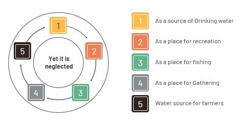

Riverfronts are desired by city dwellers for recreational purposes.Theylookforriverfrontpropertieswithsignificant physicalandvisualattractionsthatarepresentthroughout theday.Additionally,peoplewanttheriverfronttofulfila varietyofpurposesandtobealocationthatenhancesthe economic,social,andculturalaspectsofdailylife.
Water is necessary in the city for a number of reasons, includingpractical,aesthetic,andspiritualones,accordingto PostelandRichter.Unfortunately,themajorityofsignificant riverfronts today are contaminated by environmental problems, disrupted habitats, and unstable landfills. As a result, the soil and water have been contaminated. The scenario'smaindriveristheongoingandrapidurbanisation, whichraisesthedemandforalready-existingresources.
Historically, trading commodities by boat was the most effective method. Before the invention of the internal combustion engine and the materials needed to construct permanentroads,traveloverlandwithhorsesandcartson tracks was the norm. As a result, the riverfront was dominated by warehouses, where goods were kept while beingmovedalongtheriver.Additionally,somefactoriesare situatedclosetoriverssothatwastecanbedumpedintothe water.Asaresult,dangerouschemicalswerereleasedinto the waterways. This polluted large bodies of water, contributing significantly to the urban pollution problem. Theneedforboatstotransportgoodsrapidlydecreasedas road construction expanded. As a result, factories and warehouses started to move to strategic locations near majorthoroughfaressotheycouldshipgoodsmorequickly. Little was done to put the commercial space that organizationshadleftbehindovertheyearstobetteruse, andtheoldbuildingsfellintodisrepairanddisuse.
Modern urban planners recognized the potential in the vacantriverfrontproperties.Theyunderstoodthatreusing thislandcouldprovidecitieswithanumberofadvantages, suchas:increasedtourismincomeasaresultofjobgrowth Enhancedcultureandqualityoflifeinthecommunitygreen belt development in the city decreased crime along the riverfront employment generation for infrastructure constructionandmaintenancesavingtheenvironment.To achieve this, riverfront revitalization and rehabilitation initiatives were started in a number of cities around the globe, with urban planners aiming to restore rivers as an integralcomponentofeachcity.
Four priorities are frequently used as a framework for riverfront development: resource conservation, improved publicaccess,balancedlanduse,andenvironmentalquality protection.
A linear, interconnected riverfront development withwidepublicaccess
Promotingtheuseofthegreenwayasarecreational amenityanddailycommuterpath,andilluminating the relationship between market demand, access, andgreenwaydevelopment.
Creatingaseamless,aestheticallypleasingorderat thewater'sedge
Protection and improvement of the natural environment

Recording riverfront ecological conditions to protectthisecologicallydiversenaturalhabitat.
Protecting already-existing natural areas from development and preventing and, to the extent possible,eliminatinginappropriateriver-edgeuses andpractises.
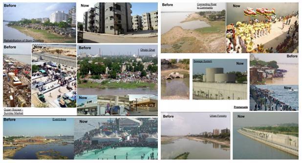
Regainthecity'sstanding asone of the top water cities.
Government revenue sources include shops, restaurants, sports activities, transportation, boating,andsoon.
Tourism development: by providing a variety of attractions such as water sports, entertainment arenas,parks,shoppingareas,andsoon.
Economicspin-offs:propertyvaluesrise,actingasa catalystforredevelopmentandrenewalofnearby areas.
Habitat protection and restoration: river water conservation, human/environmental connections, landconservationanddevelopment,floraandfauna conservation.
Riverbankmaintenanceandfloodcontrolmeasures
Provideanopenspaceforleisureandrecreationfor the general public. Creatingahealthyandactiveurbanenvironmentby revitalisingtheneighbourhood.
The East India Company established itself in Surat as a traderin1608.Thecityservedasatradeandbusinesshub duetoitsgeographiclocation,primarilythroughtheportsof theRiverTapiandtheDumasbeach.ThethreemainOvaras (Ports) constructed around 1625 were Furza Ovara, Raja Ovara,andNavdiOvara.Atthattime,thecustomscheckpoint waslocatedatFurzaovara.Ahugemetalbellhangingatthe gateringstoannounceeachnewshipthatenterstheport. While Navdi Ovara was primarily used by Dutchmen for cargoloadingandunloading,RajaOvarawasonlyforroyalty and their belongings. In 1668, the East India Company founded a business in Mumbai, and trade gradually decreased. In 1668, the East India Company founded a businessinMumbai,andtradegraduallydecreased.Upuntil 1776,shipsflyingtheflagsofupto84differentnationscould beseenalongtheTapiRiver'sbanks.TheEnglishEastIndia Company, Armenian traders, French seamen, and Dutch Mastersofmaritimetradeallcontributedtothecity'sandits culture's global fame before India's metropolises were founded.
SuratCity 2ndlargestcityofGujaratintermsof AreaandPopulation
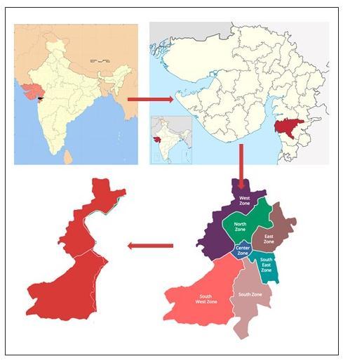
Area 326.515sq.km.
Population 44,66,826(Census2011)
Density 13680Persons/Sq.Km.(Census-2011)
Location Latitude:21.112°N

Longitude:72.814°E
lack basic infrastructure services; inflow of waste from homesandindustriesintotheriver;andtidalfloodingdueto the city's closeness to the river's mouth. SMC intends to comprehensively develop the Tapi River Front, deal with someofthechallenges,andturnitintoacityassets.
Municipality
Established 1852AD
Corporation
Established 1966AD
In terms of population and density, Surat is the secondlargest city in Gujarat and the eighth-largest city in all of India. Surat has grown significantly since the 1800s. However, the population fell by more than 15% between 1921 and 1931. However, the 1940s saw significant population growth, with the population reaching over 170,000 people. Since then, the population has grown steadily, surpassing the 1.5 million mark in 1991. The population was nearly 3 million at the time of the next census. The population has now risen to over 4.5 million people. Surat has a reputation as one of the best cities in India, having been named the third cleanest city in the country.
Atlatitude2112°Nandlongitude7252°E,Suratissituated onthebanksoftheTapiRiver,withtheArabianSeacoastto thewest.13metresabovesealevelistheaverageelevation. It is located in the southern Gujarat region, which is developed. It is 306 kilometres south of Gandhinagar, the statecapital.SuratisthegatewaytotheAhmedabadMumbai regioncorridor,witha225-kilometerindustrialareadirectly connectedtothecitiesofVadodara,Ankleshwar,andVapi. Surathasemergedasanimportanteconomiccentreofthe south Gujarat region due to its location on India's Golden QuadrilateralHighwayNetwork.
River Tapi, the river, has been crucial to the country's economicgrowthanddevelopment.Theriverisnowamajor sourceofwater,anditsbanksandbedprovideshelterand incomeforthepoor.Therearemultiplehistoricalstructures onthebank.Thereareslumsthatareatriskoffloodingand
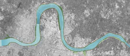
TheurbanriverfrontofTapiriverischosenasastudyarea, whichislocatedinthesouthwestandwestwardofSurat city The Tapi River originates in Madhya Pradesh's Betul districtandhasalengthofabout724km.Around5kmlong stretchofTapiriverfrontischosenasastudyarea,whichis betweenproposedbarragestopanditdindayalbridge
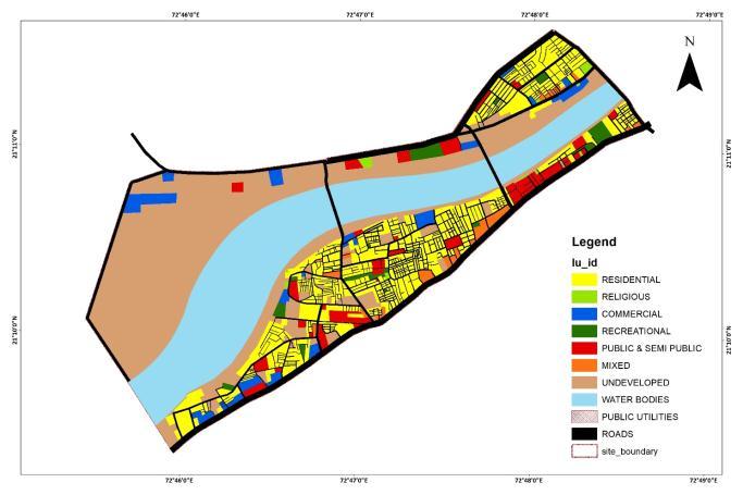
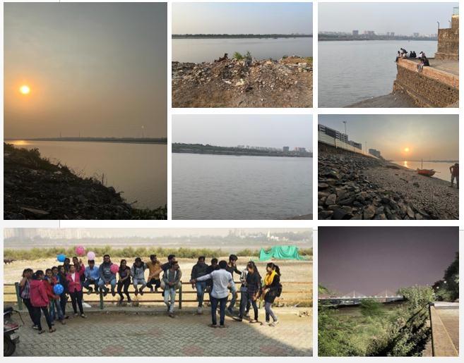
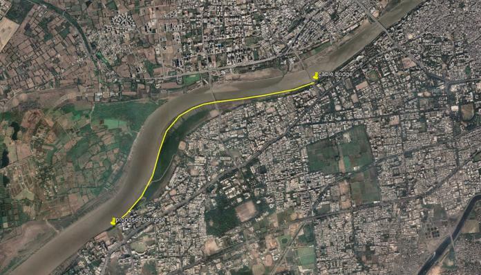
Tobetterunderstandandidentifythepatternsanddepthof factorsaffectingtheriverTapi,athoroughGISanalysiswas carried out. Total area IS 9.36 SQKM. Existing land use pattern of the stretch which mainly consist of semipublic spaces,residentialandrecreationallanduse.Thefollowing landusemainlyconsistofpotentialgovt.
TheexistingLandusemapconsistof33%undevelopedand rest67%oflandisstillnotdevelopedwhichhasthescopeof development Byembracingtheideaofmixedlanduseson vacant, which includes commercial, residential, and institutional uses, you can create an active corridor for recreationandleisure.Thesewouldincludeopenspacesfor thepublictouse,suchasplaygroundsandthemeparks,and they would be treated as open recreational areas for city dwellers.
DataorInformationcanbeisolatedintotwosorts,

1.PrimaryData.Researcherscollectprimarydatadirectly from important sources like observations, surveys, questionnaires,etc.
2. Secondary Data - Secondary data is a term used to describe information that has already been produced by earlierstudies.Itconsists ofnewspaperarticles,websites, officialrecords,books,andmore.
Safeguarding the west zone by implementing no constructionzoneof 100mfrom the edge of the river and utilizingthelandforpublicandgreenspaces.Totalareaof riverfrontdevelopmentis264.4hectare.
According to MoEF policies and guidelines, the riverfront developmentstretchcannotbelessthan2kilometreslong, andtheremustbeano-constructionzoneof10-15metres due to the presence of riparian vegetation. Because of the presence of lights, trees, and plantation along the lower promenade,itmustbeatleast15-20feetlong.
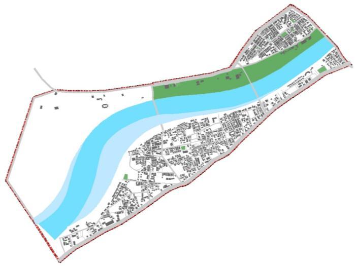
Riverfront walkway-Theriverfrontwalkwayconcentrates on developing a riverfront walk that connects people to various recreational activities and provides access to the formal market, as well as restoration and infrastructure development.
ComponentProposal
• Improving approach roads leading to pilgrimage assets along the river and Improvements to Approach Roads leadingtoPilgrimageAssetsalongtheRiverfrontWalk.
•Templefacaderestorationalongthewalk.
•Closingopendrains.
•Localarchitectureinspiredstreetlighting.
•EnhancementofthewalkwayandBenchesforseating.
Public Riverfronts are something that cities want. They desireawaterfrontthatoffersconstant,unrestrictedpublic access to the land and the water. Cities also desire waterfrontsthathavemultipleuses,includingbeingaplace tolive,work,andplay.Theriver,asanaturalpotentialand asset for the city, can provide significant benefits. Water attachmentcanbeachieved througha varietyofactivities involvingthedependentandindependentuseofwater.The goalistore-createtherelationshipbetweentheriverand thecity.
[1] Amireh,"UrbanWaterfrontPlanningandDesign.," 2020.
[2] A.a.O.B.Souers,"RestoringRivers,"Cambridge UniversityPress.,Newyork,2005.
[3] Warner,"PublicParkInventions:Pastandfuture," PrincetonArchitecturalPress,NewYork,1993.
[4] A.B.MD,"DevelopingGuidelinesforRiverfront," Pacific Rim Property Research Journal, 2011.
[5] A.H.DavinNLerner,"Howshouldwemanageurban rivercorridors?," Journal of Environmental science, 2011.
[6] P.O.O.AjeneAdamAjene,"Riverfrontutilizationin Markundi," American Journal of engineering research (AJER), 2016.
[7] M.Jagdish,"SRFDprojectforurbanmobility,"in Sabarmati riverfront development project.,
