Fabrication of Customized Surveillance & Night Vision Patrolling Drone
Krish Sonkar Devendra Kumar Rakesh Korram Churamani Manikpuri Tikeshwar Kumar5, Lalit Netam6Abstract - This paper presents the development of an affordable and efficient autonomous quadcopter equipped with a night vision camera for enhanced surveillance purposes. The drone is controlled wirelessly and utilizes high-performance flight controller technology to navigate pre-planned missions without human intervention. The use of drones in security surveillance provides real-time monitoring and control of specific areas, particularly in high-risk situations. The mission planner software enables the drone to perform and monitor its flight, providing accurate and reliable information for critical decisionmaking. The paper discusses the practical aspects of drone surveillance and proposes the implementation of real-time flight control systems to enhance drone performance. Overall, this project aims to provide a better and safer securitysurveillancesystemthroughtheuseofdrones.
Key Words: Night vision camera, Flight controller, Security surveillance, Quadcopter, pre-planned missions, etc
1. INTRODUCTION
Drones, also known as unmanned aerial vehicles (UAVs) or unmanned aircraft systems (UAS), have become increasingly prevalent in various industries. These flying robots can be controlled remotely or through software with the help of GPS, APM 2.8 Flight Controller and other sensors.Withtheirabilitytocoverlargeareasandprovide real-time monitoring, drones are being utilized for a wide range of applications, including security surveillance and crowd monitoring. In this paper, we present the developmentofanautonomousquadcopterequippedwith a night vision camera and high-performance flight controllerforadvancedsecuritysurveillance.Thisdroneis a cost-effective tool for security services to control and monitorlargeareasinreal-time.

1.1 Working Principle of Quadcopter
The working principle of a drone involves the use of various components such as a flight controller, motors, propellers, sensors, and a camera. The flight controller is thebrainofthedroneandcontrolsitsmovementintheair. It receives signals from the remote controller or mission planner software and sends commands to the motors to adjust the speed and direction of the propellers. The motors generate thrust that lifts the drone off the ground
andkeepsitintheair.SensorssuchasGPS,gyroscope,and accelerometer provide information about the drone's position, orientation, and movement. This data is used by the flight controller to maintain stability and adjust the drone'saltitude,speed,anddirection.Thecameramounted onthedronecapturesimagesorvideosofthesurrounding area, which can be transmitted in real-time to a ground station or stored on a memory card. The camera can also be equipped with additional features such as night vision, thermal imaging, or zoom capability. Overall, the working principle of a drone involves the integration of various componentsthatworktogethertoenableittofly,navigate, andcaptureimagesorvideos.
1.2 Objective
Themainobjectiveofourprojectistofabricatealowcost surveillance drone. The next objective is to calibrate the mission planning in our APM flight controller with GPS. It willprovideustheabilitytoswitchtoautopilotmode.
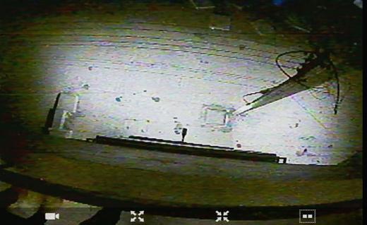
2. IMPLEMENTATION METHOD
In this proposed system, APM 2.8 Flight Controller is installed with the night vision camera which help the systemtogofortheautomationandhelptofindthehuman or any problem detected. According to the mission planning produced it automatically goes to that area and capture the image and send it to user using FPV Transmitter. Patrolling involves regularly monitoring an area by traveling a designated route. It is a method of maintaining surveillance and ensuring security. The
quadcopter captures the images with the help of camera. Theseimagesarethensenttotheuserina real time,user willanalysisitandifthereareanyproblemobservedthen triggered manually. Patrolling drone is mostly used in Highway surveillance, Military area, Restricted Zones, Industrialarea,etc.
3.
& DISCUSSION
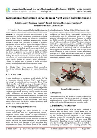
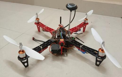
Aprototypedronewascreatedfortheproject.Itcanflyto a specific location and provide live surveillance through real-timevideo.Picturesoftheoutcomecanbeseenbelow.
We successfully flew our drone autonomously after extensive practice and research. This photo was captured during our quadcopter flight Our project heavily relies on surveillance.Toachievethis,weutilizedtheAPM2.8Flight Controller.TheFPVcameracapturesvideoandtransmitsit totheFPVtransmitter.
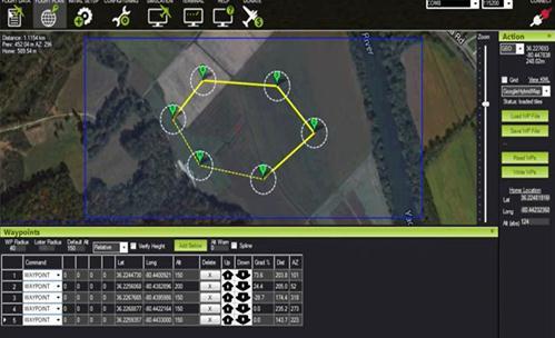
After the simulation accomplished through mission planner. In the Google map shown through the venture plannerallthewaypointwhichwepreferredforourdrone toflyautonomouslyweremapped.
After mapping of waypoint the drone will follow that waypoint and will circulatecloser to destination following suchwaypoint.
Duringflightthesearethetelemetrylogsthataredisplayed onthemissionplannerscreenwhentheaircraftisinflight. All flight-related data are displayed during flight in the mission planner. Such the roll, yaw, and pitch, our quadcopter altitude, the GPS signal, and the number of activesatelliteswhileinflight.Failsafemodes,etc.
4. FUTURE SCOPE
Somepotentialfuturescopeforsurveillancedroneprojects mayinclude:
1. Increased autonomy: Advances in artificial intelligence and machine learning could enable surveillance drones to operate with greater autonomy, reducing the need for humanoperators.
2.Longerflighttimes:Improvementsinbatterytechnology and energy efficiency could allow surveillance drones to stay in the air for longer periods, increasing their effectivenessandrange.
3. Enhanced sensor capabilities: Developments in sensor technology could enable surveillance drones to gather moredetailedandaccuratedata,improvingtheirabilityto monitorandanalyzeactivitiesinagivenarea.
4.Integrationwithothertechnologies:Surveillancedrones could be integrated with other technologies such as facial recognition software or geospatial mapping tools to enhance their capabilities and provide more comprehensivedata.
5. Increased use in civilian applications: As the cost of surveillance drones decreases and their capabilities improve, they may become more widely used in civilian applications such as search and rescue, environmental monitoring,andagriculture.
6. Improved safety features: Advances in collision avoidance systems and emergency landing capabilities could make surveillance drones safer to operate, reducing theriskofaccidentsanddamagetoproperty.
7. Regulatory developments: As the use of surveillance dronesbecomesmorewidespread,theremaybeincreased regulation and standardization of their use to ensure privacyandsafetyconcernsareaddressed.
5.
CONCLUSIONS
Inconclusion,theproposedautonomousUAVsurveillance system has the potential to revolutionize the security surveying system. By deploying a real-time video streaming system on a robust and rigid UAV, it can efficiently improve the surveillance of open spaces and areas. With the guidance of GPS, the UAV can fly autonomously, making it an efficient and cost-effective option. Extensive flight tests have verified the overall performance of the UAV and its camera subsystem. With thecontinuousadvancementoftechnology,thesystemcan be further improved and implemented in various security applications.
REFERENCES
[1] Zainab Zaheer, Atiya Usmani, Ekram Khan, Mohammed A. Qadeer, “Aerial Surveillance System using UAV” Zakir Husain College of Engineering and TechnologyAligarhMuslimUniversity,India.
[2] Martin Joel Rathnam, Abhirami Das, Deeksha.R, Divya.K, Kavya Shree.D, “INTELLIGENT SURVEILLANCE AND NIGHT PATROLLING USING DRONECAMERA”AdhiyamaanCollegeofEngineering, Hosur, Krishnagiri district, Tamilnadu, India, Apr 2021
[3] R. Prakash Kumar, Santhosh Kumar, “AUTONOMOUS SURVEILLANCE AND NIGHT PATROLLING USING DRONECAMERA”CVRCollegeofEngineering,JNTUH, Hyderabad,T.S,INDIA,May-2021
[4] Sarra Berrahal, Jong-Hoon Kim, Slim Rekhis, Noureddine Boudriga, Deon Wilkins, and Jaime Acevedo,” Unmanned Aircraft Vehicle Assisted WSNbased Border Surveillance” Communication Networks and Security Research Lab., University of Carthage, Tunisia. Discovery lab, Florida International University,USA.
[5] Shadaj Tiwari, Saumya Gupta, Shivangi Aggarwal and Satyam Kaushik, “Aerial Surveillance Quadcopter” ABESEngineeringCollege,NH-09,Ghaziabad,India
[6] Taraprasad Shadangi, Anand Kumar, Umang Verma, Mahesh Kamthe, Dr. Upasani Dhananjay, “Drone (UnmannedAerialVehicle)forSurveillance”MITADT UNIVERSITYLoni,Pune,Maharashtra,May–2020
[7] Swee King Phang, Muhammad Ali-Adi Hassan, Zhin YueWong,ZhiYuanNg,YenLingLai,“Developmentof
Autonomous UAV Systems for Low Light Surveillance Applications Using Night Vision Camera” School of Engineering,Taylor’sUniversity,Malaysia,2018.
[8] Prof. Mounica B, Sathya N, Likitha R, Meghana C A, “Traffic Surveillance Using Smart Drone” Information Science, New Horizon College of Engineering, Bangalore,Karnataka,India,2020.
[9] P. Jaya Krishna, N.V. S. Shankar, Dr. K. Srinivasa Naik, GirishBhiogade,“FabricationOfQuadcopterwithFace Recognition for Surveillance” Vignan’s Institute of Information Technology (A), Visakhapatnam, India, , August2022.
[10] 1Er. Neha karna, Sandhya Yadav, Soniya Poudel Chhetri, Swekshya Paudyal, Prabesh Gouli, “SurveillanceDrone”AdvancedCollegeofEngineering andManagement,Lalitpur,Nepal,February-2020