12 Cat. Hist. Rev. 8, 2015
Josep M. Macias and Isabel Rodà
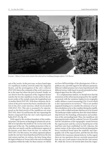
Figure 2. Minerva Tower sector; detail of the relief and two building techniques (photo: J. M. Macias).
axis of the insulae. In the port zone, we have found signs of a republican roadway network under the Augustan theatre, and the prolongation of the city’s collector (PAT-832) shows the continuity of the cardo maximus as far as the same bay where the port is located. Finally, we can observe how the expansion of the Augustan theatre matches the two late-republican insulae and how the adjacent exedra of the nymph retains the longitudinal axis of another block (PAT-83). With these elements, the location of the porta marina has been considered in relation to the city’s cardo maximus, which was located in 1940 (PAT-351). This axis is assumed to be superimposed on the final stretch of the republican-era sewer (PAT-832, sheet 14) and became the axis separating the theatre compound from the city’s early imperial port baths (PAT-355, fig. 43). With regard to the northern boundary of this residential project, the known archaeological remains do not enable us to reproduce the model of 1 by 2 actus as far as the upper part of the city. The modular projection of the insulae does not match, and the northernmost segment of the known cardo dates from the late 1st century BC (PAT-297). For this reason, two urban expansion phases inside the city have been hypothesised between the late 2nd century and late 1st century, the latter being when the legal evolution of Tarraco led to the end of residential occupation within the walls. For these reasons, we still do
001-200 Catala Historical Review 8.indd 12
not have full knowledge of the physiognomy of the republican city, and with regard to the defensive perimeter, different walled premises have been hypothesised with different terrace walls based on poorly grounded archaeological signs from the 19th century.24 In a complementary fashion, we should stress that the restoration of the urban layout proposed for the republican period, with the variations implicit in its orographic reality, defines a centuria measuring 15 by 15 actus which is also represented in its territory.25 This is yet another argument leading us to consider the existence of an urban articulation as far as the coastline during the republican era, with a walled enclosure that has yet to be located. The landscape studies underway show the ritual relationship between the founding, urbanisation and modulation of the surrounding land. Thus, the republican city planning dovetails with the cadastral Tarraco-III module and the calculations of the topographic visuals between the auguraculum and the centuria-based layout of the land have also been established via GIS. Likewise, the unitary nature of the urban and territorial planning has been considered based upon the symbolic and topographic role of the auguraculum, and this has also been related to the Caesarean colonial deductio. In this regard, there are two questions that are currently unanswered: first, the city’s road system is from the late 2nd century BC, while the Tarraco-III stretch dates from the Augus-
30/09/2015 9:06:02