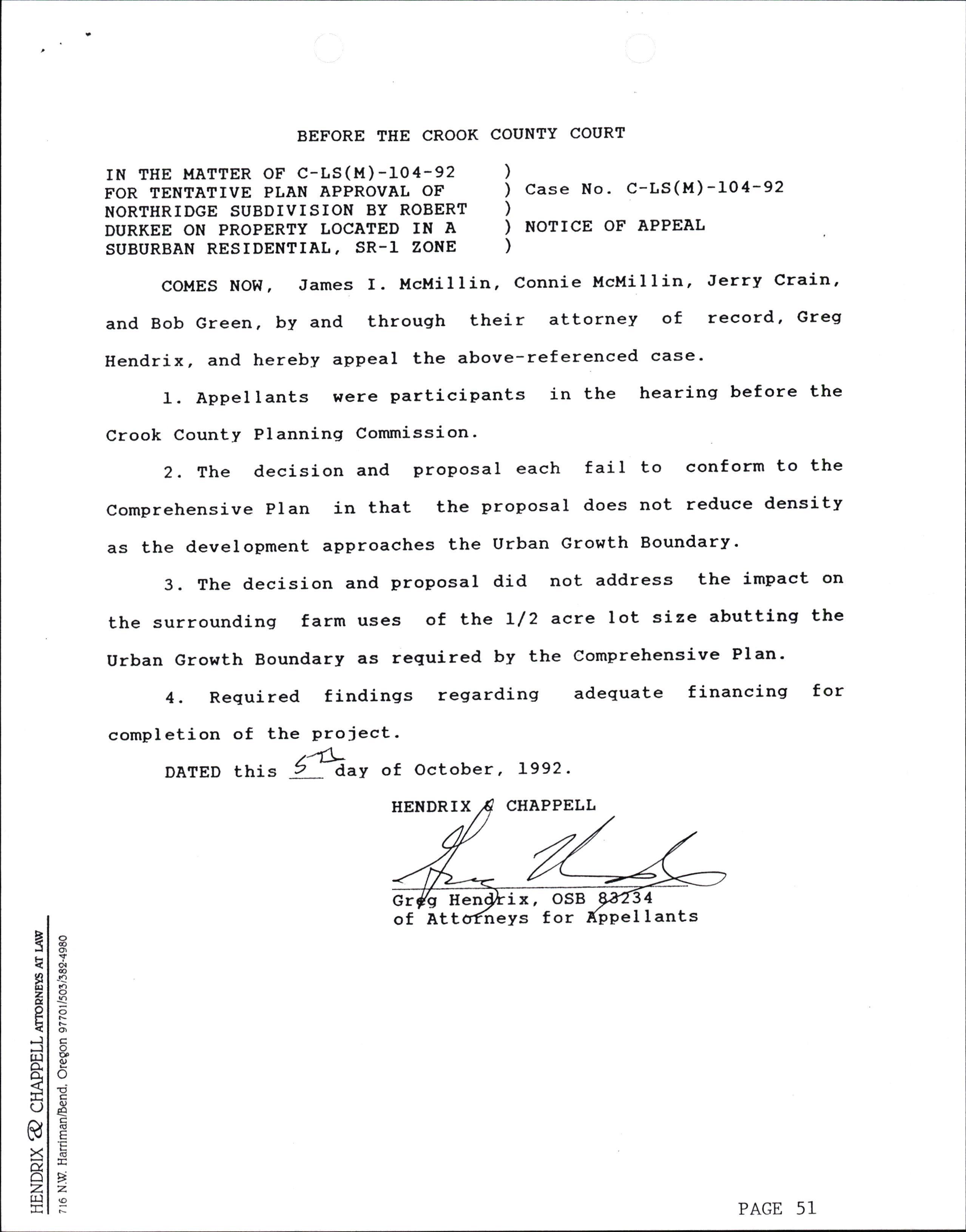
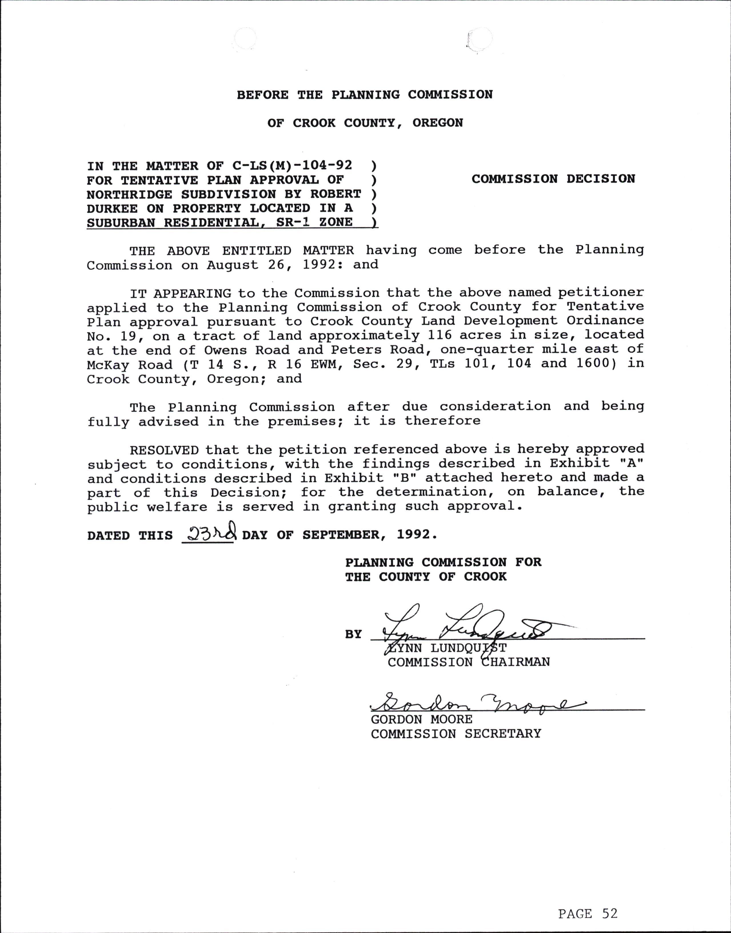
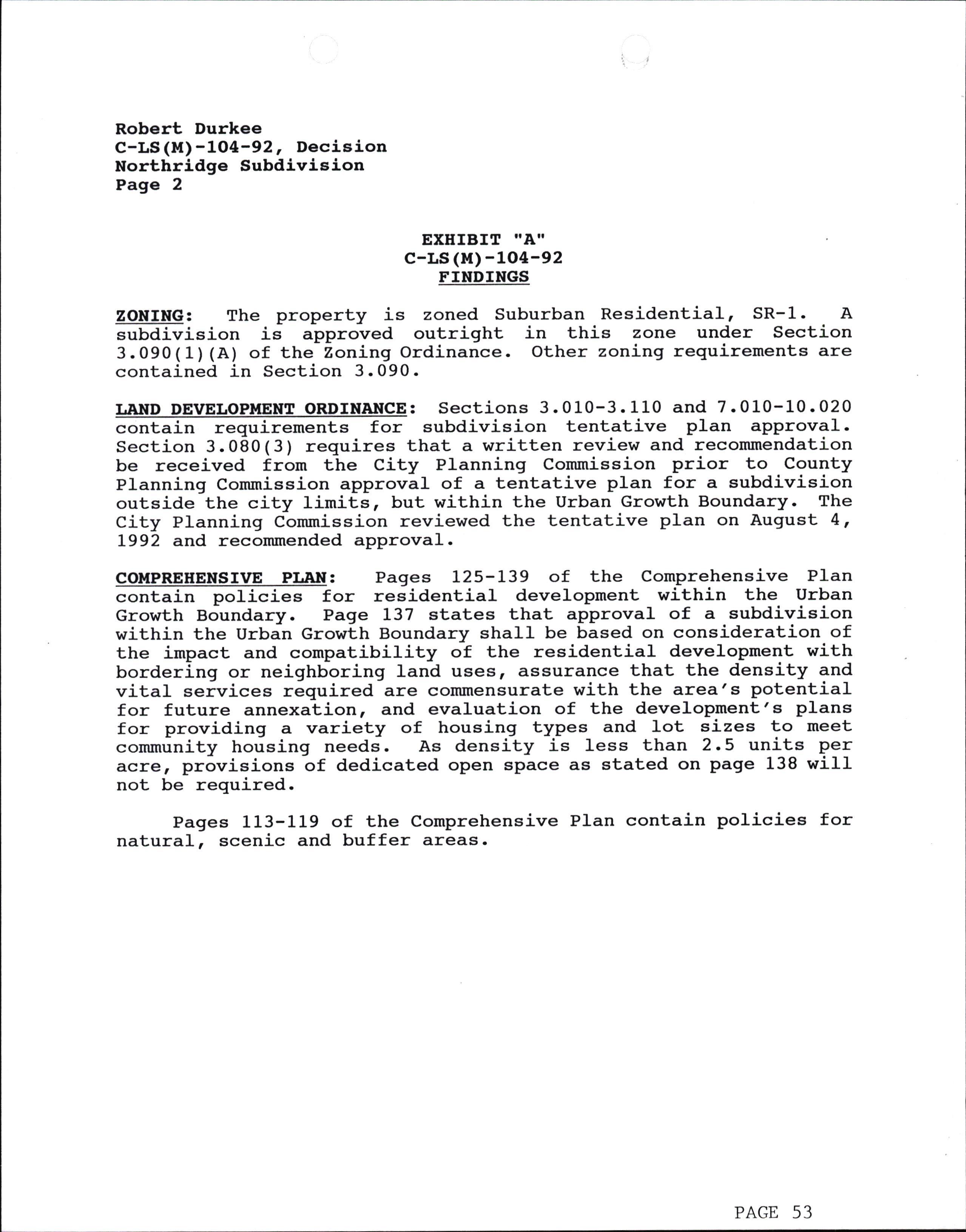
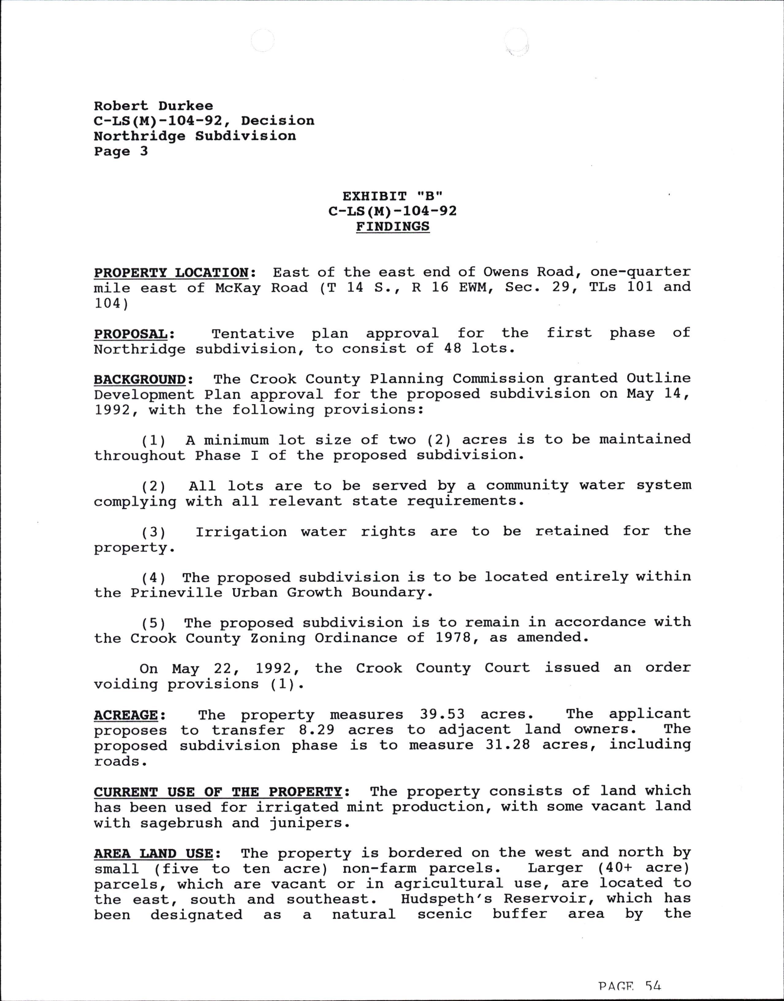
BEFORE THE COUNTY COURT oF cRooK couNTy, oREGoN
IN THE MATTER OF TEE APPEAL OF PLANNING COMMISSION APPROVAL OF NORTHRIDGE TENTATIVE PI.AN BY MCMILLIN, ET AL, ON PROPERTY IN A SUBURBAN RESIDENTIAL, SRZONE
THE ABOVE ENTITLED MATTER came before the County Court on October 28, L992 for a public hearing. The County Court set the hearing date upon receiving a Notice of Appeal, which was filed with the County Court onOctober 6, L992, at its October L4, L992 regular meeting. The Court also notes that an objection was filed on behalf of the developer by WiIIiam Zelenka to dismiss the Appeal. The County Court being duly advised by its Legal Counsel accepted the Notice of Appeal. The County Court further notes that the Appeal is governed by Section 9.110 of Zoning Ordinance #18, as amended, which limits the appeal to issues raised at the Planning Commission hearing and is anappeal on the record. The Court notes that norequest was made to introduce new evidence or arguments. It is further noted the Notice of Appeal contained three (3) assignments of error. The three (3) issues $lere the following: (1) The Planning Commission failed to conform to the Comprehensive PIan in addressing density requirements of the Urban Growth Boundaryl (21 There was a failure to address the impact of the surrounding farm uses abutting the Northridge Subdivision Appeal Decision Page 1 ) ) ) ) 1
COURT DECISION
Urban Growth Boundary as required by the Comprehensive PIan; and (3) There were inadequate findings regarding adequate financing to complete the project. Upon review of the record and in concurrence with the Appellant's attortrey, Greg Hendrix, #3 of the appeal was dismissed for consideration for failure to raise the issue before the Planning Commission. The remaining two (21 issues \^/ere considered for argument, review, and decision of the Court.
Based upon the record of the proceedingsr the testimony and arguments received, and after due consideration and being fully advised in the matter, now, therefore, finds:
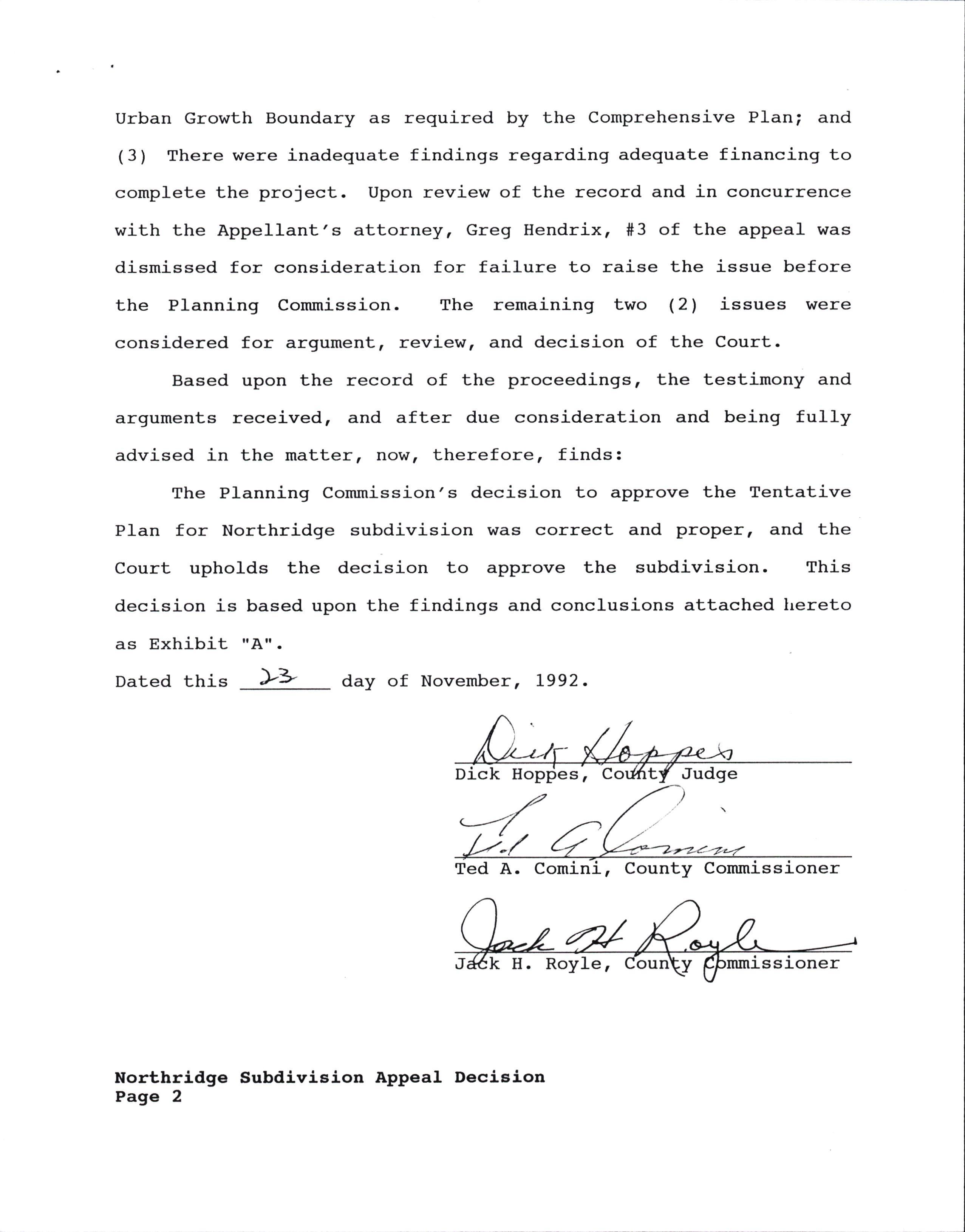
The Planning Commission's decision to approve the Tentative PIan for Northridge subdivision was correct and proper, and the Court upholds the decision to approve the subdivision. This decision is based upon the findings and conclusions attached hereto as Exhibit rrAti.
Dated this )'> day of November, L992.
D k S, Judge
Ted A. Comi ,
FINDINGS AND CONCLUSIONS
Facts
(1) The appeal packet entitled "Northridge Subdivision Appeal" on C-LS(M)-L04-92 is referenced and made part of the record. The packet contains the Zoning Ordinance criteria, Iand development ciiteria, most of the Comprehensive PIan criteria, the transcripts of the Commission hearings, and evidence submitted at the hearings.
(21 A request to dismiss the appeal dated October L4, L992 was received by the County Court by William Zelenka.
Based upon a review of the FACTS, the Court CONCLUDES the following:
(1) The Court rejects the request to dismiss the appeal on the grounds that the Appellants filed the Notice of Aprpeal as directed by the County, and therefore, it was a proper filing.
(21 When the Comprehensive PIan is considered in its entirety, the density of the subdivision conforms to the Court's interpretation of the Plan's goal for development.
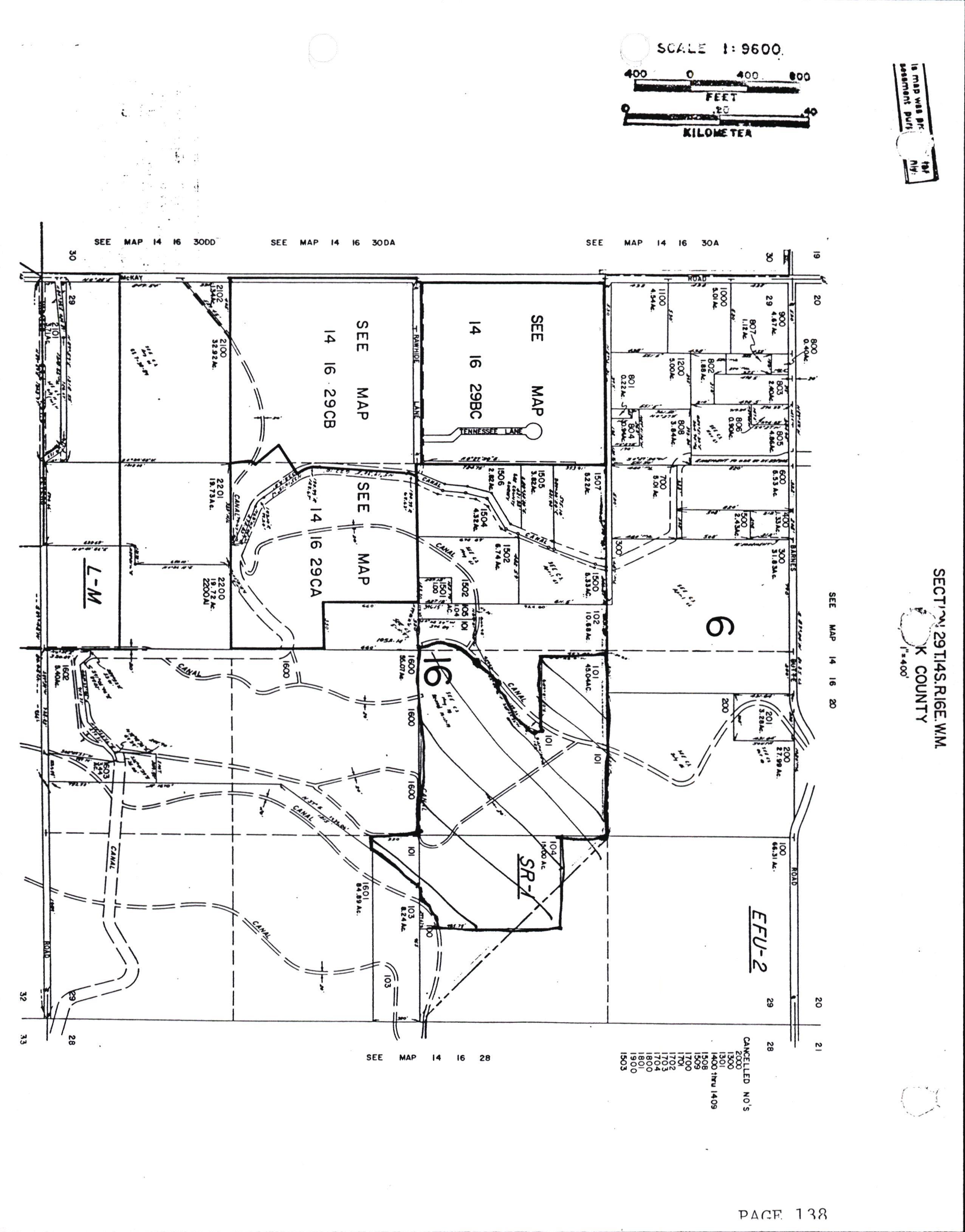
(3) The language of the Plan on pages 10, L25, I34,136 and 138 support the proposed density of the Northridge subdivision. The Court notes that will fuII services, the permitted density by the Ordinance could be 51000 square foot lots. The Court would agree that on the fringe of the UGB, that density would not be appropriate.
(4) The Court had previously reviewed the density issue, and ordered the proposed density during the Outline Development Approval.
(5) Section 9.110(12(B) of Ordinance #18 places the burden of proof upon the appellant to show the decision was legally or tactually improper, and not that this body would interpret the issue differently. The appellant fails in his burden to demonstrate the decision v/as legalIy or factually improper. Further, this Court maintains its original interpretation of the density issue. A review of the record further strengthens the Court's conclusion that the density for this development as proposed is proper.
Northridge Subdivision Appeal Decision Page 3
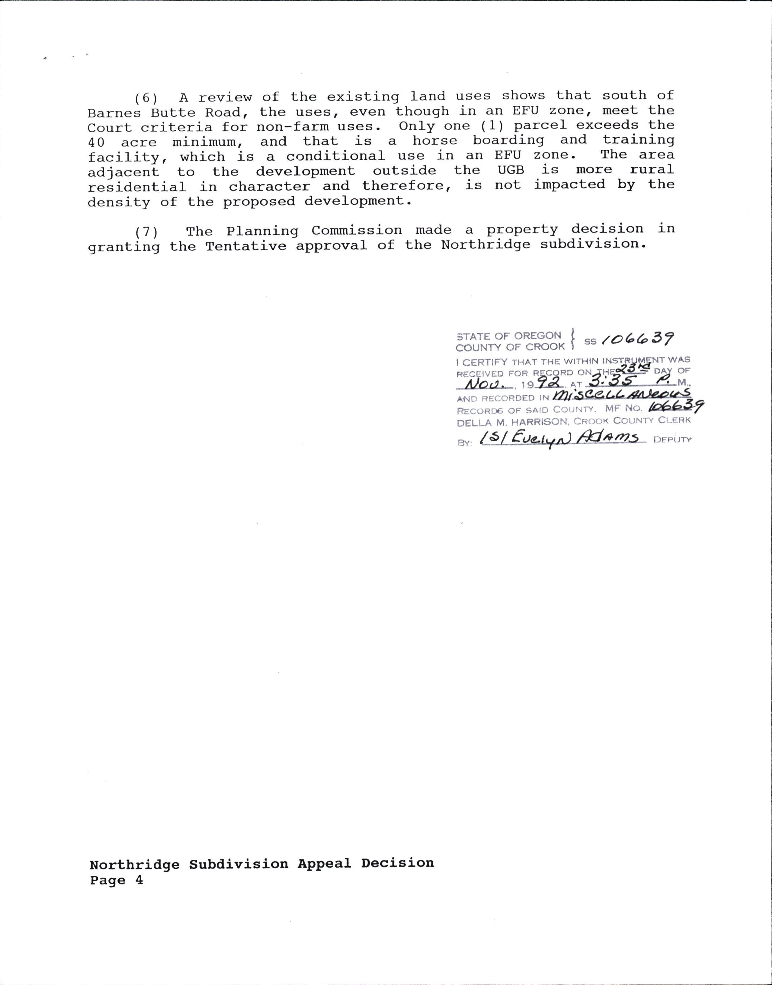
( 6 ) A review of the existing land uses shows that south of Barnes Butte Road, the uses, even though in an EFU zone, meet the Court criteria for non-farm uses. OnIy one (1) parcel exceeds the 40 acre minimum, and that is a horse boarding and training facility, which is a conditional use in an EFU zone. The area adjacent to the development outside the UGB is more rural relidential in character and therefore, is not impacted by the density of the proposed development.
(7) The Planning Commission made a property decision in granting the Tentative approval of the Northridge subdivision.
Subdivision Appea1 Decision Page 4
STATE OF OREGON COUNfi OF CROOK I CERTIFY THAT THE WITHIN
ANO RECORDED IN FIECoRDG oF sAlD Cour'rw. MFNo' I ss ro6b3/ wAs OF DELLA M. HARRISON. CROOK COUNTV CI.ERK *,@DFP(-,*
BE IT REMEMBERED THAT at the regular meeting of the Crook County Court, begun and held on Wednesday, November 4 t L992, at 10:00 a.m. in the County Courtroom, of the Courthouse in Prineville, Oregon, this being the time and place prescribed for such meeting, there were presLnt: Dick Hoppes, County ugdgg; Ted Comini, County CommiJsioner; Jack Royle, County Commissioner; AIan Rappleyea, County Counsel and Chris Manchas, County Court Secretary.
The press was advised of the meeting, but did not attend.
WHEREUPON THE FOLLOWING PROCEEDINGS WERE HAD TO-WIT:
IN THE II{ATTER FAIRGROUNDS:
OF EXTENSION OF URBAN GROWTH BOUNDARY NEAR
Judge Hoppes opened the meetirrg. The first item was advertised as a PubIiC Hearing, and the following citizens were piesent: Ray Shumway; Jacque -Bushong; Gary Timmerman, Fairgrounds Managgr; Hugh Oragic-h, pri.r"ville, City Councilman and Fred Rodgers, Crook County Judge-elect.
County Counsel \f,as asked to review the material in a draft ordinince, regarding the amendment of the comprehensive plan and zoning ordinance map for Crook County-
Counsel explained that the document contained language, that i-f approved, -wou1d bring addit,ional land into the Urban Growth Abirndary. ft" land in question includes 33.03 acres, and approxiirately 6.73 acres of Chat is currently owned by Bolby F. ald Geneva V. Kennedy of Prineville. The Kennedy's plan to donate the 6.73 acres to tlhe Crook County Fairgrounds, once the land is accepted into the Urban Growth Boundary.
The draft Ordinance has already been reviewed and approved by-the City and County Planning CommiJsions, which each held the required two hearings oh the matter prior to approval.
The prineville City Council had discussed the document, but Fre{ Rodgers, who was fresent at that meeting, stated that the land des6riplion they r6viewed varied from the one shown today. Coun-se1 reviewld the malerial and said that because some adjustments had been made in the description, the material will be discussed with it" City Council membeis at their Tuesday, November 10th I L992 meeting.
AIan also said that the other acreage mentioned includes land tontaining the Amphitheater and baseball fields owned PV !tS Crook County paiks and i,ecreation District. By having this land brought into th" Urban Growth Boundary, city water and sewer services can U- prorrided to the described l-and, and also change the designation of ihe properties from Agricultural to Outlying Commercial, with the ,ot'itg: *"p designation from Exclusive Farm Use, EFU-2., ,to Recreatio.i Cor*erciai, R-2, which are described in the exhibits attached to the proposed Ordinance.
COUNTY COURT MINUTES
LL-4-92 PAGE 2 OF 6
MOTION: The Court members reviewed the wording of County Ordinance 73, and following discussion of those documents, Commissioner Roy1e made a motion to approve Ordinance 73, subject to solidification of the exact acreage involved, through a survey to be completed by Dave Armstrong, County Surveyor. Commissioner Comini seconded, unanimous.
Dave Armstrong will necessary before the advised to complete any survey work transfer takes place. be Iand
IN THE MATTER OF TIMBER REPRESENTATIVE ON COIC BOARD DISCUSSED:
Hugh Dragich said that because the loca1 person currently appointed as the timber representative to the COIC Board, Dave Howard, had not been attending the meetings, he should be replaced by someone who would have the time to be involved with the Board.
Commissioner Comini had mentioned this to the court members at the September 2, court meeting, and it was their feeling at that time that Mr. Howard should be replaced by someone with more time to dedicate to the meetings.
Mr. Dragich gave the Court members the name of Lee Tomlinson, as someone he felt would be a possible candidate for appointment to the Board. Since none of the Court members were familiar with l{r. Tomlinson, or his connection with the timber industry, they decided that Commissioner Comini, who works with the COIC Board, should contact Mr. Tomlinson, and find out what his qualifications are, and his interest in serving.
MOTION: Because of the need to put someone on the Board as soon a possible, Commissioner Comini made a motion to appoint Lee Tomlinson, contingent on him qualifying for the position once he is contacted. Commissioner Royle seconded, unanimous.
Fo1lowing the meeting, Commissioner Comini contacted Mr. Tomlinson, who lives in PoweII Butte, and is employed by the W.P.C. Corporation in Bend. That company assists small wood lot owners with marketing their products. tr{r. Tomlinson agreed to serve on that Board. Mr. Howard will be advised of the change.
IN THE MATTER OF RESOLUTION REQUESTED BY COUNTY CLERK:
DeIla Harrison, County Clerk, asked the Court members to consider signing a resolution that would enable her to perform marriage ceremonies after regular work hours and on weekends and keep any compensation she receives for doing so for herself.
COUNTY COURT MINUTES
LI-4-92 PAGE 3 OF 6
Del-Ia said that not aII, but some other County Clerks around the State, have made similar requests of their County Commissions, due to an ethics guestion being raised regarding the funds received while doing marriages outside of normal business hours.
The C1erk also said that if she had not been compensated for a ceremony she conducted in Portland, and another in B1ack Butte, it would not be worth her time to provide those services.
Judge Hoppes said he not only questioned whether it would be ethically correct for Della to keep any money received for performing a marriage service, but even if for some reason it was shown to be ethically correct, he questioned the propriety of keeping the money received. He said since the ability for Della to perform marriages, is only because she is the County Clerk, money received should remain with the County, since Del1a is compensated for serving as the County Clerk. The Judge also raised the question of an elected official using his or her office for personal gain, as another reason he felt it was improper.
Della responded to the Judge's comments by saying that if she was not permitted to keep any compensation received for performing the mentioned services, she would discontinue performing any marriages, whether during work hours or not.
The Judge told Della that decision would be her own, but that he still had a problem with the Court approving her keeping the money.
County Counsel was asked if he had any information regarding this mattei, and Counsel said that the ORS statutes that deal with the Clerk performing marriages, stated that there did not have to be a fee collected for doing a marriage. Counsel said further that he felt that the statute languagJe would allow the Clerk to charge for performing a marriage, if she chose to.
MOTION: After more discussion, Commissioner Comini made a motion to table a decision on the request, until County Counsel could research the matter further, and also talk with the Ethics Commission, to get anopinion from them. Counsel will provide the Court with any information he locates.
IN THE MATTER OF RE-LOCATING THE POSTAGE I{ACHINE:
Della also told the Court that she wanted the County postage machine moved from the election room, Iocated in a room adjacent to the Clerk's office, to another location. She said having the machine in the election room created problems for the people working the election for up to three weeks prior to the General
COUNTY COURT MINUTES
LL-4-92 PAGE 4 OF 6
Election which was just he1d. She said that she felt the machine could be placed on the ground floor, in the same room the copier is in by placing it behind the door.
Commissioner Roy1e mentioned that the back half of the room mentioned is is office. Commissioner Comini suggested that the area she mentioned belooked at, before the Court makes a decision on the relocation, and the other Court members agreed.
IN THE MATTER OF HAVING A VEHICLE AT THE AIRPORT TOR USE BY PILOTS:
The Court members briefly discussed a Ietter regarding having a vehicle available at the Airport for pilots that fly in and need transportation to town. The Court members felt that it would be up to the FBO/Managex t to provide such a vehicle, if he chose to do so. The FBO/Manager would be allowed to charge a reasonable fee for that use in order to cover expenses.
Commissioner Royle wiII discuss the issue with Lee Sitton, the current FBO/Manager at the airport.
IN THE MATTER OF REQUEST TO NAME ALCOHOLISM PLANNING COMMITTEE:
Karen Kramer, of the 1ocal Mental Health Office, sent the Court a Ietter asking the Court members to appointr or designate, a committee to serve as the Local Alcoholism Planning Committee (LAPC). The appointment of the committee would be in accordance with the l.,lenta1 health Administrative Rules (OAR 309-52-035).
Karen's letter mentioned that Dr. Rinehart, had been the chairperson of the committee for several years, and once he left Prineville, the committee had stopped meeting. Attached to Karen's Ietter was a list of nine local people who were willing to be appointed to the LAPC.
Commissioner Comini said he fett the list of people requesting appointment consisted of a majority of professional people. The Commissioner said that lay people should be sought to have an equal number of professional and lay people appointed to that committee.
The Court members decided to table a decision on the appointments, until Judge Hoppes could contact Karen Kramer, and advise her of the Court's discussion, and give her the opportunity to respond.
IN THE MATTER OF RV LICENSE REVENUES ATLOCATED TO COUNTY:
The Court members reviewed information received from the State Parks and Recreation Department with Mary Jo Johnson, Treasurer. Oregon County
COUNTY COURT MINUTES
IT-4-92 PAGE 5 OF 6
That information stated that the County could apply for an estimated $1590 in funds from RV license fee revenues. The State uses county campsite information, the most current population estimates, and projected RV registrations, to arrive at each county's estimated allocation.
Any County wishing to apply for the funds must submit a County Certification Statement, that is signed by the head county official, and submitted to the state. RV funds may be used for any county park and recreation purpose, but cannot be passed through to federal agencies, cities or special districts.
The Court members discussed the criteria set out in the information. Commissioner Comini and the Treasurer had also talked with Kathy Spero, Special Projects Coordinator, of the State Parks Office, and each reported what they had learned from her about the program.
Following discussion, the Court members decided that with the fairgrounds RV Park project well underway, the County should be eligible to receive the funds available through the program.
MOTION: Commissioner Comini made a motion to submit the forms requesting the funds and when received, the money should be aliocated to landscaping the Fairgrounds RV Park. Commissioner Royle seconded. Unanimous.
IN THE MATTER OF REQUEST FOR PRINTER AT HEALTH DEPARTMENT APPROVED:
The Court received a written request from Connie Hoffstetter, County Health Department Administrator, asking for a new printer for that department.
Connie,s letter exptained that there are currently three computers tied into one printer. She said that af ter talking with t'li\g pawley of the Finance Office, she felt a Panasonic KX-P4410, would best suit her needs.
According to the information, by using $429 from the flu vaccine Iine item, which was not used, because the cost of the vaccine was Iess than anticipated, and also $200 from other operating exPenses, there was enough money within the Health Department budget to pay for the request.
MOTION: Based on the information received, Judge Hoppes made a *otion to approve the request, once a clarification of the source of the flu vaccine money is obtained from Connie. He said this because the request did not state whether those funds were from the County general fund or State grant funds. If State funds were
COUNTY COURT MINUTES
LL_4-92 PAGE 6 OF 6
involved, the Judge wanted to be certain the State had approved the expenditure. Commissioner Comini seconded. Unanimous. (It was learned after the meeting that the flu vaccine funds were from the County general fund).
IN THE MATTER OF CITY TO CONTRIBUTE FUNDS FOR WELL PROJECT:
Commissioner Royle reported that he had contacted Henry Hartley, Prineville's City Manager, and asked if the City would be willing to contribute funds to go towards the cost of drilling a well at the Houston Lake Industrial Park site.
The well is currently 500+ feet deep, but the volume of water is not sufficient for the Industrial Parks projected needs.
Commissioner Roy1e said that Mr. Hartley had agreed to give $5r000 towards that well project. He also said that geological information he received showed a good possibility that a large amount of water could be located by drilling a deeper weII.
IN THE MATTER OF NORTHRIDGE APPEAI UPDATE3
County Counsel told the court members that he had not received a draft of the final order on the Northridge appeal hearing decision from BiII Zelenka as yet.. BiII was ordered to draft the decision after the Court found in his client's favor on that matter.
Counsel said he would contact BilI to see when the Court might expect to receive that material.
IN THE MATTER OF LIGHT INDUSTRIAT PARK TENTATIVE PLAN REVIEW:
County Counsel said that he expected the County Planning Commission would be reviewing the plans for the proposed Airport Light Industrial Park, at the November 18th meeting. The plans were taken through the process in the past, but never formally approved by the Commission. Counsel will keep the Court updated on any progress made.
He said he hopes that the Planning Commission can re-activate their previous Tentative PIan approval and then the County could go for finat plan approval. once approval is given, the final order approving the site could be drafted and signed.
MEETING ADJOURNED - /cam
BE IT REMEMBERED THAT at the regular meeting of the Crook County Court, begun and held on Wednesday, October 28, L992, at 10:00 a.m. in the County Courtroom of the Courthouse in Prineville, Oregon, this being the time and place prescribed for such meeting, there . were present: Dick Hoppes, County Judge; Ted Comini, County -Commissioner; Jack Royle, County .Commissioner; Alan Rappleyea, County Counsel and Chris Manchas, Court Secretary.
The press was advised of the meeting, but did not attend.
WHEREUPON THE FOLLOWING PROCEEDINGS WERE HAD TO-WIT:
IN THE MATTER OF REVIEW AND PAYI,TENT OF BILLS:
The bitls were reviewed and approved for payment as submitted.
IN THE MATTER OF NORTHRIDGE SUBDIVISION APPEAI HEARING:
The Court reconvened at 1:30 p.m., which was the time set to hear an appeal of the Tentative Approval granted by the Planning Commission for the Northridge Subdivision.
The following citizens were present: Greg Hendrix, a Bend Attorney, and his client Jim Mclrlillin. BiIl Zelenka, a local land use consultant was present representing Bob Durkee the developer of the Northridge Subdivision. DaIe Runyan was also present.
This hearing was tape recorded.
Judge Hoppes opened the hearing of the appeal Commission decision on C-LS-M-l04-92 Northridge granted tentative approval to that subdivision.
of the Plann Subdivision wh ing ich
The Judge stated that the hearing would be limited to the record already established, that the proponent and opponent testimony would be limited to 10 minutes with a 2 minute rebuttal for each and then called on Alan Rappleyea, County Counsel/Planning Director, for the staff report.
The Judge asked if any Court member wished to declare any ex-parte contact or conflicts of interest, and none \ilere stated.
County Counsel llave a staff report and stated that all procedural matter had been satisfied as far as the Planning Department was concerned.
Judge Hoppes called on Greg Hendrix to give the proponent testimony.
Greg stated that he represented Jim t'lcMillin, Jerry Crane and Bob Green in this matter and reviewed his client's reasons for filing the appeal.
COURT MINUTES
LO-28-92 PAGE 2 of 3
BiIl Zelenka was called on to reviewed his client's case. give the opponent testimony and
Following the testimony, both gentlemen were allowed two minutes for rebuttal testimony, and following that Judge Hoppes closed the hearing.
The Court members reviewed and discussed the material presented. During that discussion, the Judge said he felt in interpreting the total Comprehensive PIan, when addressing efficiency and density, the Planning Commission made a proper decision in granting the tentative approval of the Northridge Subdivision.
After more discussion, the Judge made a motion that the Planning Commission decision be upheld for the reasons he already stated. Commissioner Comini seconded. Unanimous.
As the prevailing party, Bill Zelenka was instructed to prepare the order for the Court's signature.
IN THE MATTER OF VISIT TO SEATTLE FFA OFFICE DISCUSSED:
Commissioner Royle said that he felt the County might benefit if he, and other people representing the County, made a trip to Seattle to speak directly with FAA representatives. The main issue he felt needs to be talked about is the FAA's objection to the proximity of the landfill to the airport due to their concern of the landfill attracting birds which would then be a hazard to aircraft using the airport.
The Court members aI1 felt that the data they had collected, regarding the number of birds observed both at the landfill and airport, has shown that there were very low numbers of birds observed at either location. Several pilots that use the airport on a regular basis had been asked for their comments and each had responded that they felt that the low number of birds they observed did not pose a problem to them.
The Court members agreed that Commissioner Royle should talk with the FAA representative and suggest he and other representatives would like to meet with them. The Court members also agrees that County Counsel should accompany the Commissioner on the trip.
(Commissioner Royle contacted the FAA Office following the meeting. The Commissioner also contacted Bob Franklin, a pilot for Les Schwab, and Mr. Franklin made arrangements to fly the Commissioner and County Counsel to the Seattle meeting. That meeting was set for Thursday, November 19th.
COUNTY COURT MINUTES
LO-28-92 PAGE 3 of 3
IN THE MATTER OF INCREASED APPROPRIATIONS RESOLUTION/ 92 242
Mary Jo Johnson, County Treasurer, .came to the meeting to ask the court members to consider signing a resolution to allow for the expenditure of unanticipated additional grant funds and contributions by the departments the specific funds were designated for.
The Court members reviewed the resolution and agreed that the funds designated for the Health Department WIC, family planning, HIV prevention, and child care should be approved. They also agreed that because they had not been provided any information on how the funds listed for the DARE program were to be spent, that portion of the resolution should be deleted.
MOTION: Following the discussion, Commissioner Comini made a motion to approve Resolution 92 - 24 with the deletion of the DARE program funds untit an explanation of the plans for those funds is received by the Court. Commissioner Royle seconded, unanimous.
IN THE MATTER OF BUDGET TRANSFER REQUESTS APPROVED:
The Treasurer also asked the Court members to review and approve three budget transfer requests. The request was made to change the method of paying the person hired by the Health Department, on a part-time basis, to assist in administering some of that department's programs.
Money that was previously allocated to pay the salary for Lois Walsh, a local nurse, who is no longer working for the County, would be transferred from general fund-Walsh to general fundhealth/other contract. This transfer was made necessary because Dawn David, a local licensed Physician's Assistant, had agreed to work for the Health Department in the same position previously held by Lois Walsh, but her licensing requirements would not allow her to be hired as an employee. She will therefore be working on a contract basis.
MOTfON: Commissioner Comini made a motion to approve the request as outlined and Commissioner Royle seconded. Unanimous.
MEETING ADJOURNED - /cam
William P. Zelenka
Appraisal & Land Use Services ,$i$
October L4, 1992
Crook County Court County Courthouse
Prineville, Oregon 97754
RE Notice of Appeal for Tentative plan Approval of Northridge Subdivlsion
on october 6, 1992, the county planning Department received the above Notice along with a check for 9300. Robert Durkee, the deveroper of Northridge subdivision, requests the county court dismiss the Notice of Appear on the basls of the folrowing.
Pursuant to section 9.110 of ordinance l+ l.g ,Every tand use decision relating to the provision of this Ordinance made by the Conmmission, hearing officer or other official of Crook County is subject to review when appealed within ten (10) calendar days of date the decision was final in accordance with state statutes and the followlng provisions.
The Notice was filed October 5 Decision was September 23, L992. , L992. The date of the
Section 9.110(9t3bl requires the Notice of Appea1 be filed with the County Clerk.
The Notice was sent to the planning Department then dld the appellantrs job with the County Clerk.
Department and the and flled the Notlce
Pursuant to Section 9.L10 (10) the Court needs to determine if the appeal was properly filed
The Notice of Appeat not only was not timely filed and with the proper authority, It is appealing the Decision the Crook County court made on this matter on Hay 27, 1992. (ls z & 3) pursuant to Sectlon 3.030 (3) of the Land Development Ordinance iThe purpose of the Outline Development Plan ls to make a determlnation that the particular proposal complies with the Countyts Comprehensive plan and the applicable zoning provisions. The review by the Comnission shall determine whether the proposed subdivision as submitted wiII have detrimentar impacts upon the generar area and that the partliular site ls capabre to be devel-oped as p=opo="a. (4) The aDProval or disaporoval of the Outline Develooment PIan bv the Conmlssion shall be final unless the decision Is aopealed to the Countv Court. The aoproval of disapproval shall be binding uoon
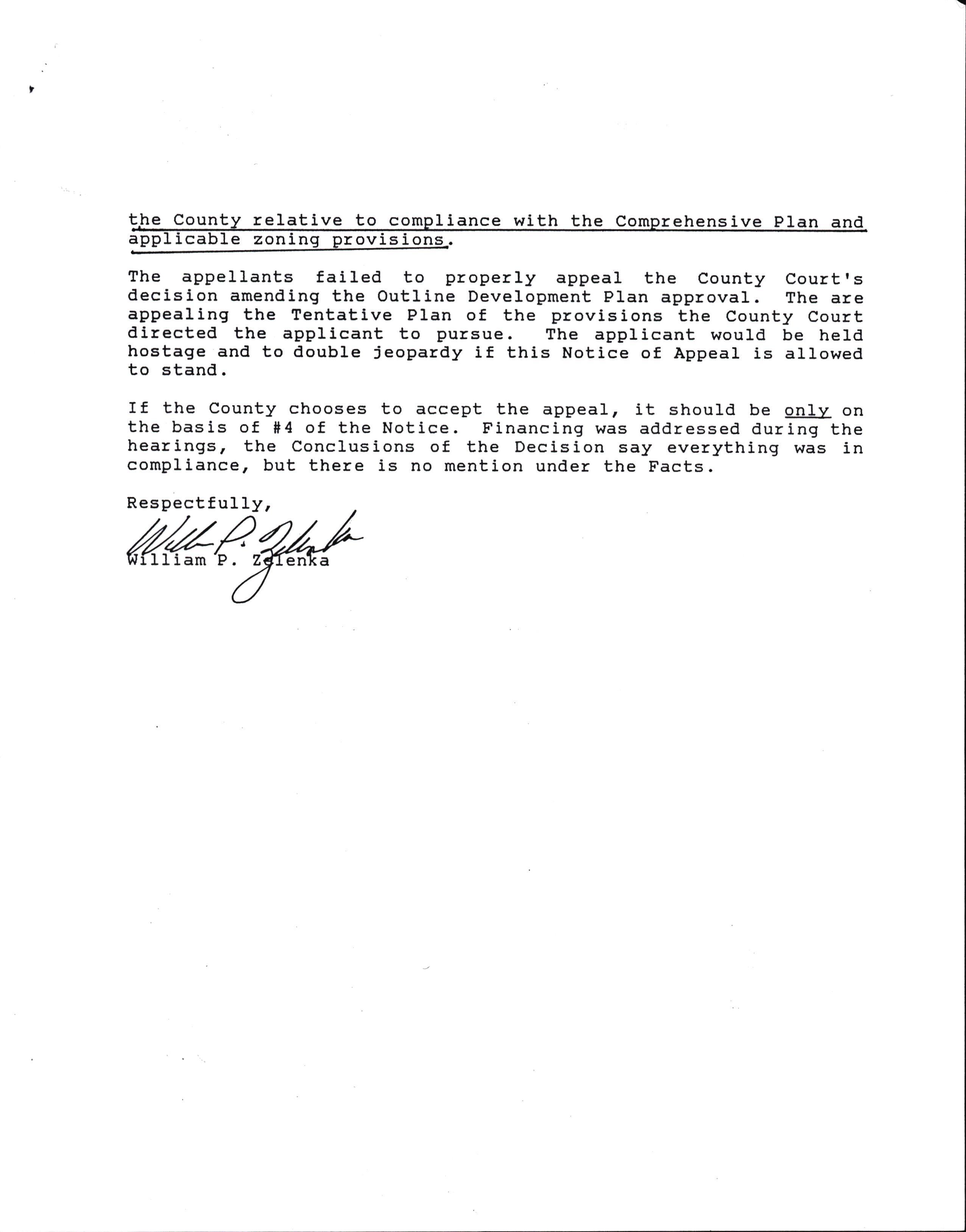
!.he Cqqnty relqtive to compliancq with the Comprehensive Plan and apflicable zonin rov1s1
The appellants failed to properry appear the county courtrs decislon amending the Outline Development PIan approval. The are appealing the Tentatlve PIan of the provisions the County Court directed the appricant to pursue. The appricant wourd be herd hostage and to double jeopardy if this Notice of Appeal is allowed to stand.
rf the county chooses to accept the appeal, it shourd be only on the basis of #4 of the Notice. Financing was addressed during the hearings, the conclusions of the Decision say everything was in compliance, but there is nomention under the Facts.
Respectfully,
I am e a
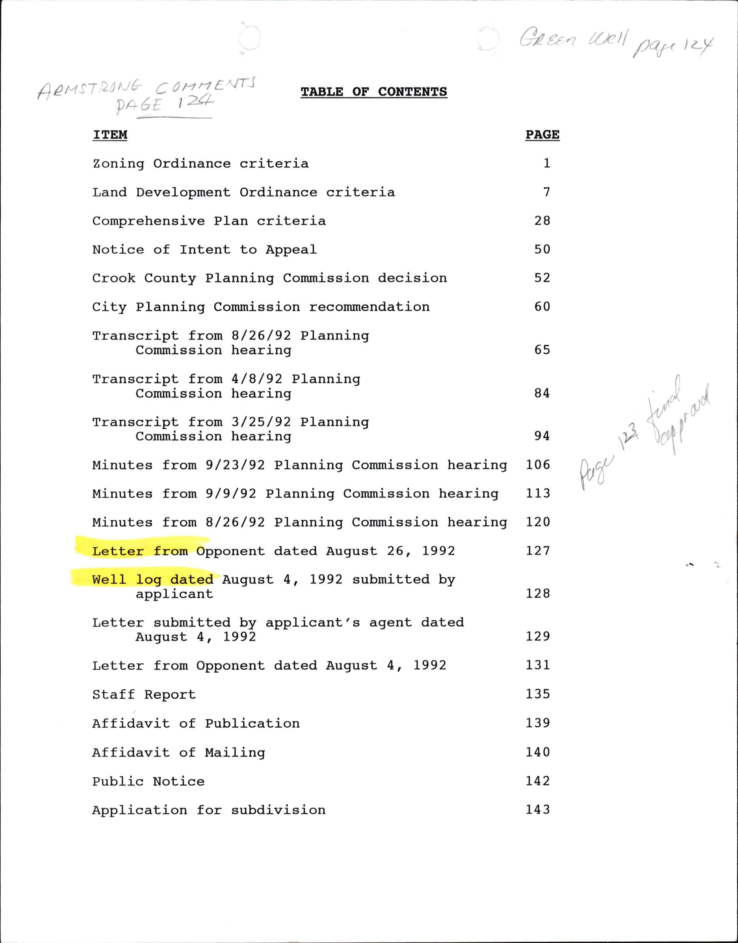
Zoning Ordinance criteria
Land Development Ordinance criteria
Comprehensive PIan criteria
Notice of Intent to Appeal
Crook County Planning Commission decision
City Planning Commission recommendation
Transcript from 8/26/92 Planning Commission hearing
Transcript from 4/8/92 Planning Commission hearing
Transcript from 3/25/92 Planning Commission hearing
Minutes from 9/23/92 Planning Commission hearing
Minutes from 9/9/92 Planning Commission hearing
Minutes from 8/26/92 Planning Commission hearing
Letter from Opponent dated August 26, L992
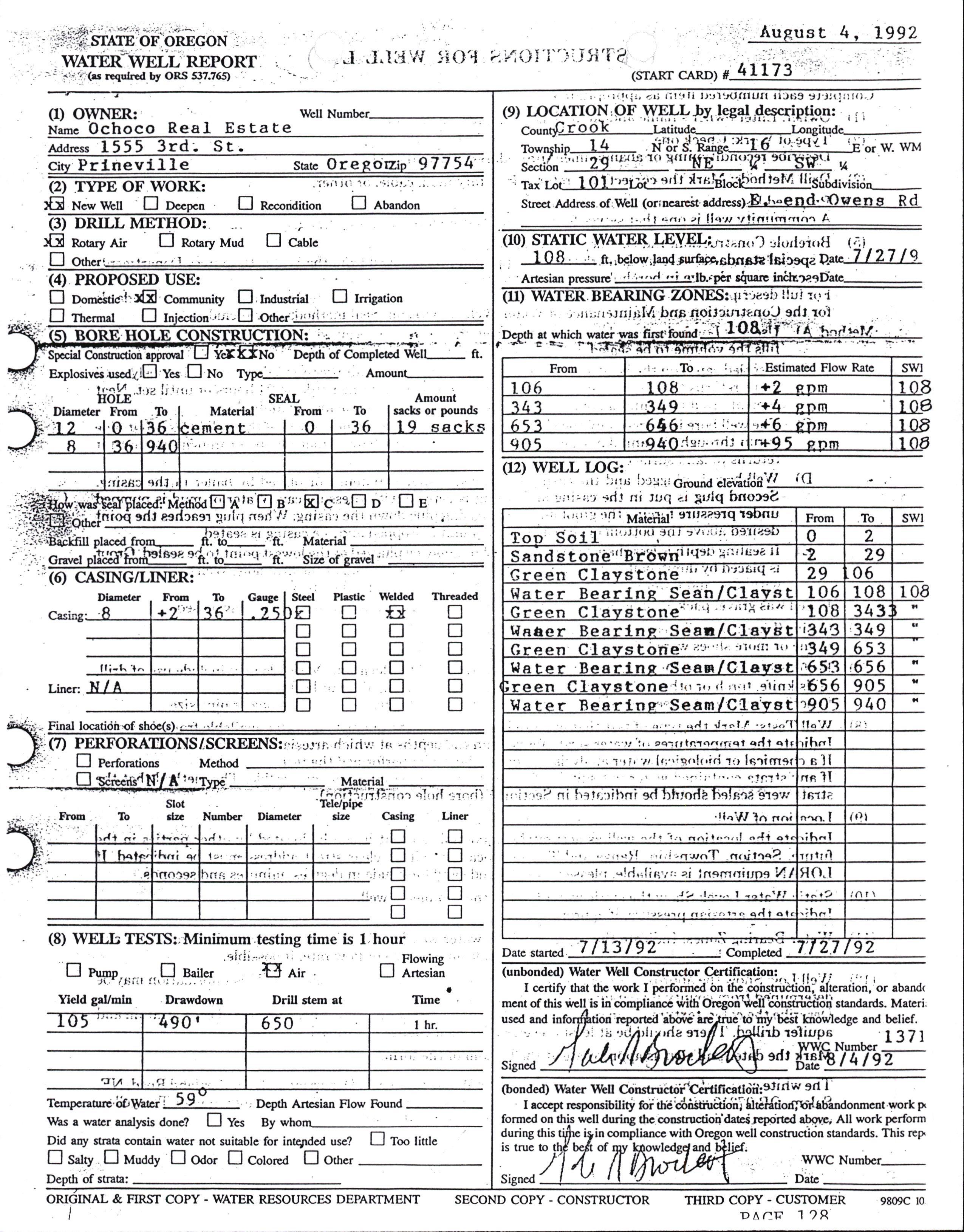
Well log dated August 4, L992 submitted by applicant
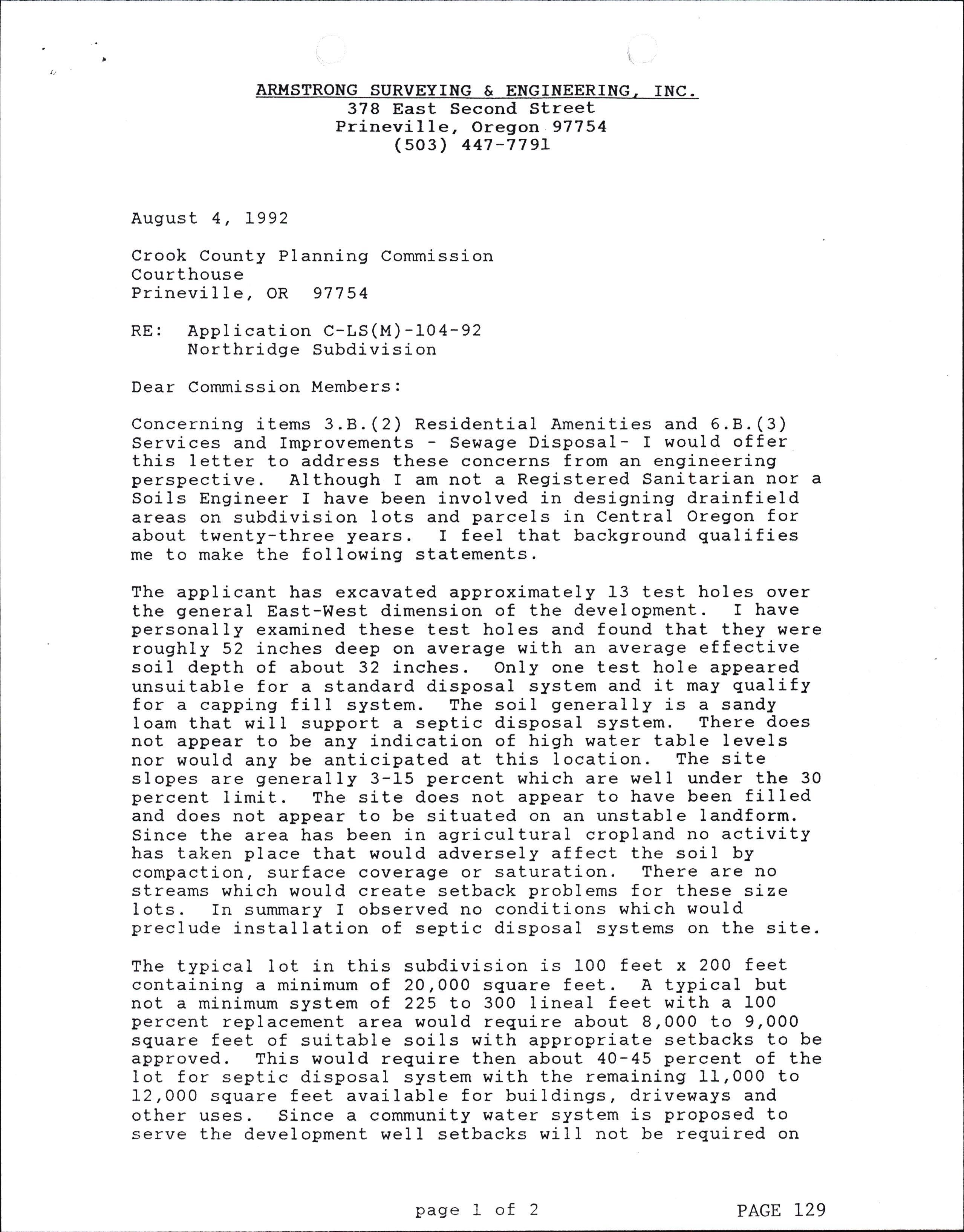
Letter submitted by applicant's agent dated August 4t L992
Letter from Opponent dated August 4, L992
Staff Report
Affidavit of Publication
Affidavit of Mailing
Public Notice
Application for subdivision
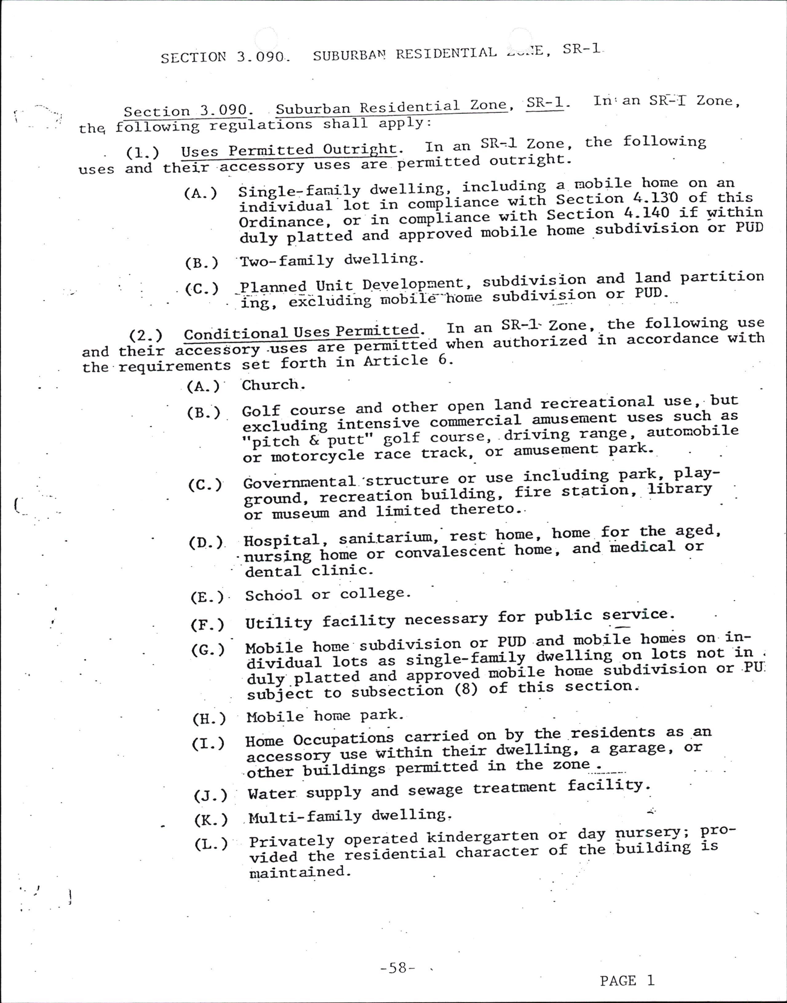
Section 3- 090- Suburban Residen i-a7- Zone, SR-I- In,an S[-:f Zorte, E thq o owrnS regu ations sha
1I app ryt
. (1.-) Uses Pern'.ritted oucright: -Il.2n SR-l Zot:.e' uses and their accessory uses-Ei-e permitted outrightr'
(A- )
(B. )
(c- )
che following
Single:fanity dwe1ling, -including ? r':obile home on an individual f"t-ir-"o*[iir.,"e w1t[ Seccion 4']3'0 of this Ordinance, "i-i,.--""*piir.,"" wich Section 1r110-if within ;;1;;1"tl"a-";e "ppi""ta mobile home 'subdivision or PUD 'Two-familY dwelling
PlarrnedUnitD.e.velopnent,subdivisionandlandpartition -iiE,*:iaiiiailI i,"[iis-r,ome subdivis.ion or PUD-
(2.)ConditionalUsesPermitted...InanSR-].Zone'thefollowinSuse andtheiraccessory.uses"ffia,t.".,authorizedinaccordancewith the requi="*"iil-ti.-i"ittt in Article 6' Church.
(A- )
(8. )
(c- )
GolfcourseandotheroPenlandrecreaEionaluse,.but excluding intensive commercial arnusement uses such as ;;i;;h-&-potti--s"ri "o.rrr., ariving range,. autoEobile "I-;;';";";;i; =i"" Erack,- or amusemenE park' Governnental 'structure or use including par!c,. PlaYsror:nd. ,."t"Ili"Il-Ulrifaiog ' fire station ' library ' 3i-""r"6um and limited thereco''
(D.) Eospital-, sani.tari*:-rest ttoP"' trome for the aged' 'nurs:.ng home ot "orrt'"fe"i"nc home ' and iedical or dental-clinic'
(8.) Schciol or college'
(F.) Util-ity facility necessary for public service:
(G.)MobilehogesubdivisionorPllDanduobil.ehomesonindividuallots as "r"ii"-i"*iiy dwe1lin8 91.19ts not in duIy.pr"ct"a-and "ppiii"EElir: hooe rubdivision or'PIr subject-;;-;ubsectibn (s)of this secEionj
(H- ) Mobile home PatI'
(I.) I{one Occupations carried oa-by-the residents as 'a11 accesso;-;; withiutheir dwe11iug, a gara*e' or
(J.) lJater supply and sewage t'reatment facility'.
(K. ) t'Iulti-fa-i lYdwelling' {'
(L-) Pri-vately operated-kindergarEen o1 day F'T::Ty; P:ovided the resioencial chaiacter of the building rs
(M- ) C ^ cultriwation or farm and Planc nurseraes ' rck gardens, i-ncluding
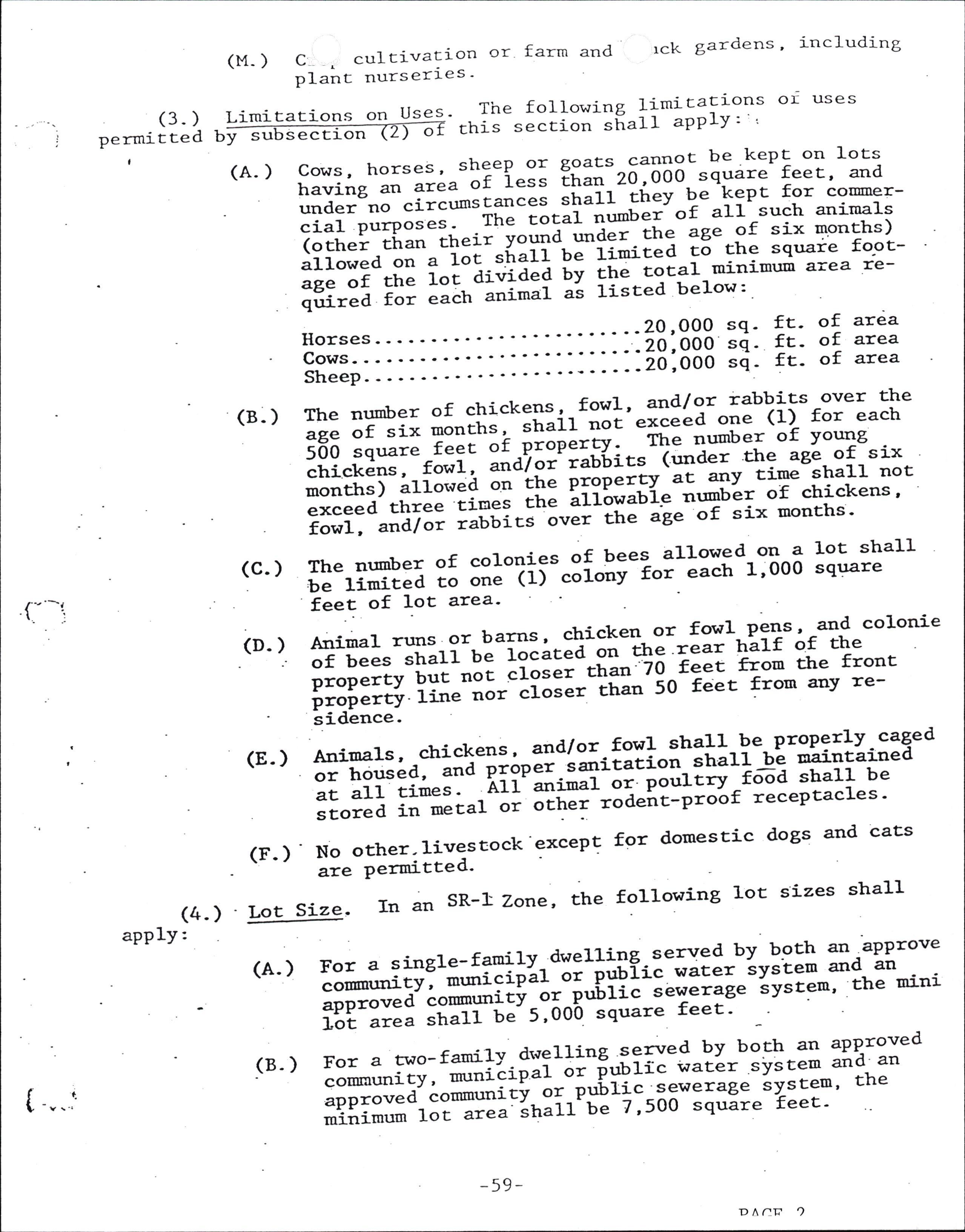
Limitatrions on Uses- The following IimiE.atrons or uses (3- ) permitted b , sectron o chis section sha11 aPPIY: ysu
(A. ) Cows, horses , sheeP aofl or goats carrnog be kepE on lots e,ss than 20,000 squire feet, and having an are ces shal1 theY be keP t for coumerunder no circumstan tocal nurnber of al1 such anirnals cial purP(other th oses. The under the age of six months) an their yound hall be1imited Eo ttre squaie fogt- allowed on alots total minimum area reage of the 1ot divided by theted be.Iow: qrrired for each animal aL Iis
Horses
Cows
Sheep
(4. ) apply:
20,O00 sq20,000 sq20,O00 sqft- of area ft- of area ft- of area
(B-) The number of chickens-t-fowl ' "!!t-"' rabbits over the age ot 5; ;;";il! ' st'"ir not exceed one (1)for each soo "q;; il;; ;t -P;ri;"Yt T-:-'umber of Young chickens' fow1, and/oi'rab6its (r:nder 'the age- of six ,"itt ir -i,o'o"i "''l:
Lxceea- three tiu-eg Ehe arrowl":':^f3':;*";;;;; fowl, and/or rabbics'o'"t the age of six months'
(C. ) The nrmber of colonies of bees allowed on a lot shal} be t-iniieato one (li-";i""y for each 1'000 square i""t of lot area'
(D- ) Animal runs or barns , c\ickeL:t*:::'on"i?";r"t$"co1onie of bees shal1 be located on the 'r front proPertv"ilii-ooi "r"lli-*tan:'7o -f"..--x from the ,ror",$ ii;";;'-"i"""' itran 50 feet from arrv re' sidence'
rnd/or fowl strall be propgrlycaged (E- ) *'ffiH;.:';5Ti;r:;:;itati.on- Itiu rt-uiint-aiued at a:.l-ii*t"' Arr #;;i-;t lourtrr f6d sba1l be srored in meral "r Ji#i*r"a"ii-pro-of recePtacles '
(f.)' No other-livestock'excep! for domestic dogs and cats are Permittred'
Lot Size. In an SR-I Zorte, the fo]-lowing 1ot sizes shall
l1ing served uY b.9t! 1-,"1P=o'" -t"uii" water svstem an<t arr ublic serrerag"-iYit"m' the mini square feet t For a rwo- rTll$Ii':l"$'fr iil"*i.I=o 3}:.:*_31'iF"' {tri:::l i:E::ill"iil;*'} :;,;; il*: "' t: :::'':" minimum lot a
(A. ) For a single-fa-rnilY- dwe ;;*,-itYl muriciPal or rrrto.r"d cotunu:nitYor ^P 1i"'.- "=ia sha1l be 5'ooo
(B- )
(
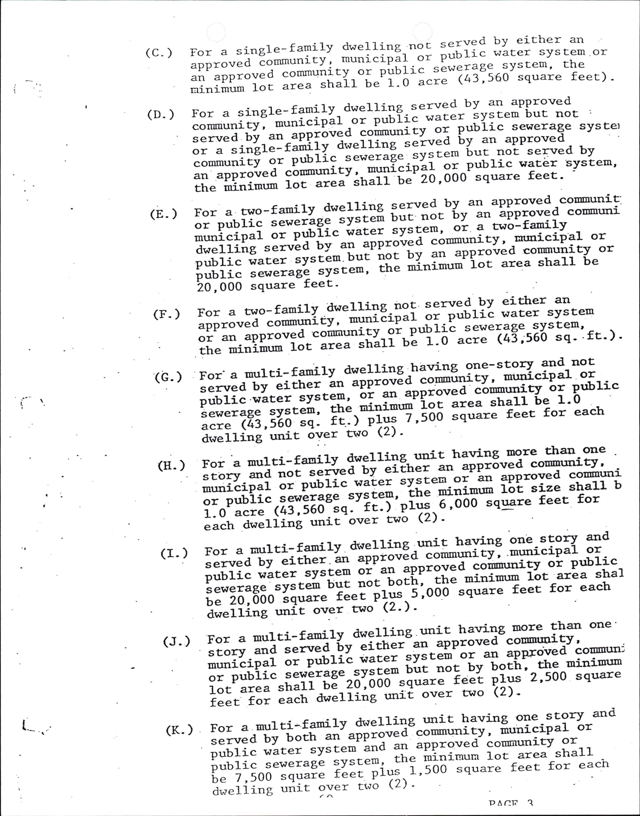
(C-) For a single-family dwelling-not served by ei-ther an ,pptor"d Eommunity' rnunicipll-o' public water system or an rpptJt'Ii"t""*tl;tity "i plulit s-ewerage system' the rainimr:mlocareashallbe^1-0acre(43'560squarefeet)'
(D.) For a single-family-dwelling-served by an approved "o*,,,,-"I:';";;ipir-;;-;;ilii: '1-t"' svste, but not : ::x" gt:i,::':mi;ti*"1ru": ;i:?: Bllll-:r;lii:8" s vs'Eer communiti o= ptrblic ;;;;;;Et'sYitem tut not served by "., "pp =oie d cb"-untd,;Htli:; lt, S6onllll:"'?::Isvstem' the ilinimrjrr 10c area snart uE Lv'vv
(E- ) I:'nioil: ::Hliu!::ilHi ::*i:"k :"31r?Ht,:ffi** municip"i ot n$Iic vrater system' ;iiaf or dwel]-ing served uy "i*Ii;';;;a cormunitv' nuni' public iaEer "y"."r-bui'irot uy ?n approved couurunity or pubrlc sewerage- systH; fi; iioi-" i"t area sha1l be io,ooo square feet
(F-) For a tv'o-family -dwe11.ing-no9 served by eitJrer an ,ppro..,Ii-";'*,-'ity''iitti:-Eipar 9T -p,,utic water syste, or "II lrnio'"a .coi*'fitv--i' puurlt sewerage qystem' th" uifipiffi;"iI.-ir" j*li'"ri-b""f - 0-";;;- (45 ;56-o sq - ' rt- ) -
(G.) .For' a -rnulti-f-anrly dwelling -halrilg gne-stor7-3nd not . servect by eirher "o-liii"rEd "o*i'.tty, uunicioal or pub1-i'c'*-ater systen' Li att "pptoJJa ""tri**'ity b= pnblic ' sewerase svstem' *t; ;itffi-iil i'"^ sha:-l- Le 1'0 acre (43 , 560 sq ' tt']l"ii$; ' 500 "q'"=" feet for each drvellinl't"tic 6t'er cwo Q)' .multi-faldl.ydwelling.urrittrawinglnorethanrone
(E- ) For a ryl'l::':::,.;-ir-EiIuer arr approved co stoaJr and not ""*"E"ii-EiEugi^1t tpp'6ved co'r'murrity' mr:nicipal or public wlix.t sysEeEL or'in ?PProYed columlIrllor pubiic seingf?ge '"vli"''-tr" 'iii''o 1bt si'e shaLl b t-o acie (43,560.:n:'il]i'piy:'iltiOo-square feet for each i"Lii"i-unic'ot'"r two (2)
(I- ) For a urulti-f-amily dwel-1ing r:nit harri:rg 91:=:tor7 and served by either *'-;;;"'iEg-391'**t'iryl 'mr:nicioal or pub].ic 'Lter sysF:en oi' "rr 'pp'oyfa -""ifrt"ti9y oi pub1ic " ",.,I gl ^ ;;; : = ; *:"ft ,* :tl ri#,ru1re"}l' r3la 3 ;1"' be 20,000 square reeE PIX-\-'-"' a;"1d;;"";it-"'."' to,o- (2') '
(J.)Forauulti-farn:=lydwelling.unitha.rringIno]retharrone. scory ;a-;";;d-9v-"itt'er an aPProved-cormunity' . uunicipal or nui|il ;;;;-9v".Ei,'o= ",. approyed cousnrn: - or pubiic sewer-ase^:':iF !i:-llt-uv botir-' tJre uiuiuum 1ot aiea shal1 -be-26"ooo "qt'?:? i""t Plus 2'5oo square reet 'l;; ;;;i-a'"rii';-*'r; over two Q)'
(K.) For a mulri-family dwelliqe unit !1'tuq 9?:.story and served bv boch ",, ;;;ii"d"1111"'oiiv' iuuigyal or i:Bi* ;::ii;:1i:t,liit liri:ii"i:{:: :i#: : "' f" 7'500 square feet PrY:tr'"" rYuqr= d*"lii;; "iit 9X"' t'b Q)' p^/:tr ?
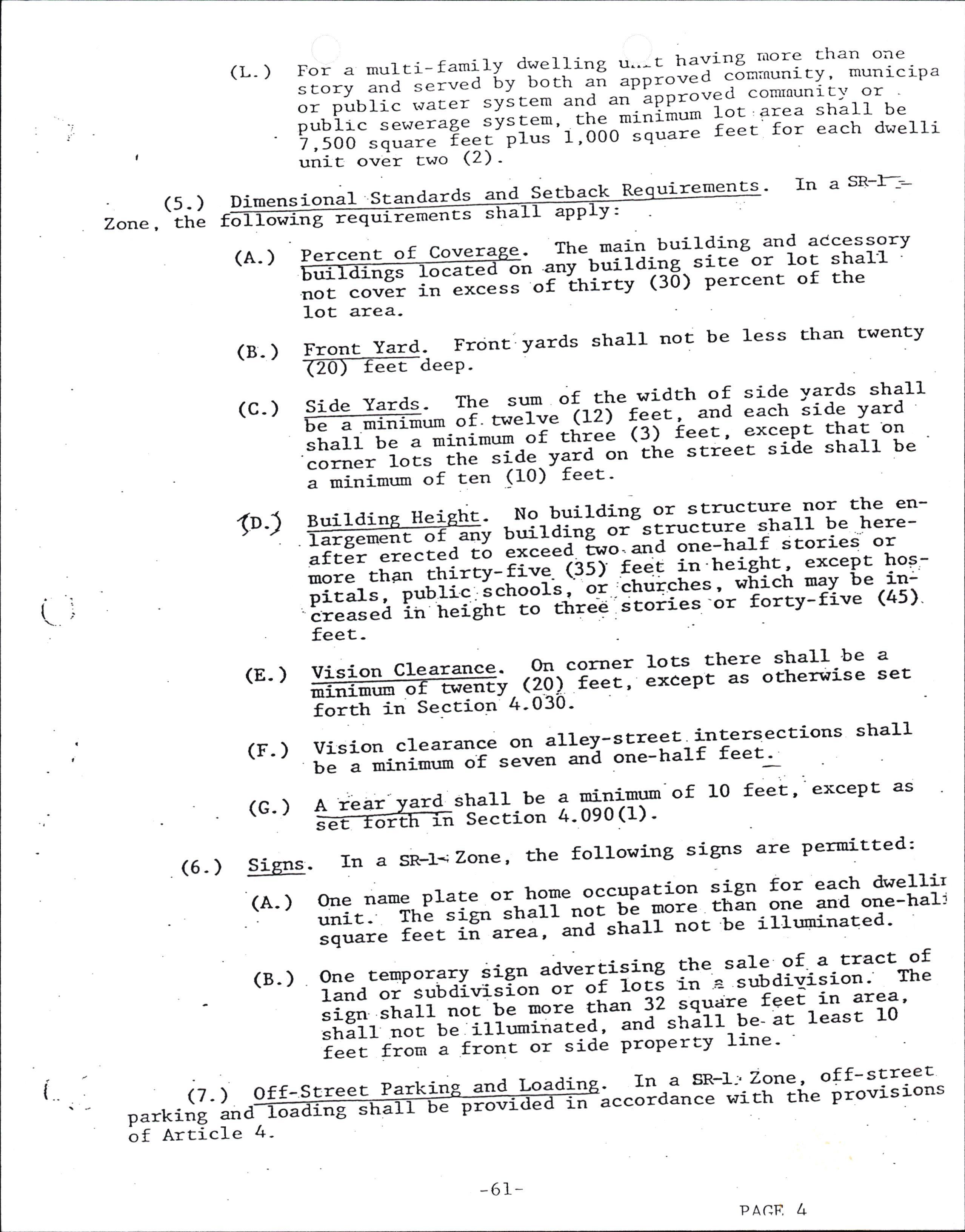
(L-) For a multi-family dwelling u"-t having rrrorc than one sEory and =.r'"'"a 6y both ai lppi"'"a^corn;nunicy' municipa or publi" .rrc.i-tt;Eem and'"t''!ppto'?1*to*taunicl' or pubric ."r"tr!l tyt-t"*' che-mitl-in'-t* lot' ar.ea shalr be 7,50o square ?Zgy';i;;':-'ot5o^"iq"=" feet for each dwelli unit ower two <2) '
Scandar ds and Secback Be uirements. In a SR-I-:(s. ) Zone, the Dimensional o g req remencs s a APP v:
(A. ) Percent of Cover The main building anq accessorY ror-Urrilding sice-or lot shal1 "i-tniity (30) Percent of the catre on not cover in excess
(B- ) lot area
Front Yard. Frcint: yards shall not be less Ehan twenty
(c- )
1o-)
IZO.J-TEet-deeP P i d! I?=.d:.:* *: *"""fl,"" t, 5l" rX:: : ": 5 : ::f; i iip -r:!it' :i"ii*i:'lTt.irum-or tt'rel ?:j reet ' excePt Ehat on corrrer lors .ir.*Ja"-y:ia ot'tire street side shall be ;_;i;ir; of ten (10) feet -
Buildi He ht. No building or structure nor the enbuilding or structure shalI be heregement o any exceed. two artd orre-ha].f stories or ?fter erectedto t in'height, excePt hoF,rnore than thirtY-fiwe. (.3s) fee which maY be in: pitals, pubJ-ic in hei schools , o-r 'chuiches, (4s) ght to ttrreg 'itories -or fortY-five creas feeted
(8. ) ffi ,frr'?*;: l?::r:o::"":I3l*'!E 3". ;;;h;*-seccion- 4' 030
(r. )
vision clearance on alley-screet lnqerqections shal1 be a minimr:m'"i-""t"o oti orr"-half fee. '
(c. ) A rear ard sha1l be a minimun-of 10 feet' excePt as -Slccion 4-090(1)' se n
(6- ) Signs'
(A. ) In a SkI-; Zorre, the following signs are permitted:
(B-) One name plate or home occupation sign for each dwellir unit. The sign sha11 "ot tE-i;;; 'h;'one and one-halj il;;;" ?".t-ii""i"I;-;a-";hi-oo. be illr:ninated'
One temPorary sign advertising the sale of a tract of land or subdiri"iorr orof 1;; in a subdiaision'' The sien sha1l .,oi-U"-more ttran :2 9q93r: feetin area' strltt noc be iIh:minaced, "tl-thit1 Ut- 'c leasc 10 i"Ii^ri;; ; f;;;t;i side ProPerty line-
{ (7- ) an parking of Arti c1e 4-
,,o,"I?i]" t#r€i*?% ,-a.fy platce<l'and JPproved.*:b11:-l::" ;"-;;;=tved in compliance t+.ith seccr-on
llobile homes Perni:ced bY "r.-;;i lo.aced- on a lot-within -."Uairision or PUD' shall onlY 4-I40 of chis Ordihance'
ARTICLE 7
DEDICATION OF SfREETS NOT PART OF A SUBDTVISIOI{
Iication. Any P erson desiring to creaEe a
Section 7.010 - A or najor P artition sha11 make written streeE noE Parc of a sub vis l-on d Iicati on shall be o the Planning DeParEIDent. Sai APP anied by the required application t r-Ded forms, and shaII be accomP made on Prescr riate fil ing fee. information and aPProP
Section 7.020. Minimum Desi Standards . The mininmm standards of a street shall be the ts within a subdivision Uf" street standard reB- of design and iuprovement rth in thi-s rt e cat same as set fo ordinance for stree and sha1l be in comPlianc e with ocher aPPlica ulations.
Section 7-030' Procedure.
(1)upon receipt of written application a-nd 3#::E:1":f;rft"tt fee for stre"I-aeai"aE'ion' the Planning refertheproposal.tothecoumnissionandCountyRoadDeoartmenr for revilw and ,".oo,rJid;i;". twJ ;;;i;; of the proposed dedicarion, wrirren Iega1 ;;;;iptigo, .and iropos"d improvernenr shallu"-io*rra"[ ."-Itt.-E"r*i"iion at lLast ten days prior to " ="g"i"ify scheduled ueeting'
(2)
(3)
(4) (5) (6)
I.lhere access is to a Countv Road or State tti$trl111--9" necessary p"rii.I-"t"if U.'"il]ir.a prior to aPPro'al by the CountY Court'
The comission and the Road Department shall rePort their findings ro;il.*i;la;ille di=E.tor and give their reco endations regarding th;';;F;"i-{-dEdication and iurprovements. The Corrnlssioo =Uaff'"tlo recoumend a classification for the ProPosed street '
Uoon receiptofwritten findings ltd-f:"o endations from ttre Cornrnissioi-ana-Rg"a Oep"itilent, the proposal "n*1.be subuittea-io-ite county' court for prelim:inary rerrt-ew and approval. ""s;;h "rru.ii"i""-in"rr 6e made aE least Een days prior .o '-I"E'r"ity sctreduled meeting
Upon preliminary aPPrqYil by the- County Court' the engineering and improvefoent! desigi'oi- ttre 1914""" confo:mi'g to the requir.rl.rr"-or rhi-s ;iaio"oce and otirer applicabLe regulatior," '!iriif-U" -rrUriic"a-i" tire Cotrnty Road Department for revierv and approval. -i;ia engi,eerins and improvements design shalt-'be-il.p"r"a ,ii-JiilEt by a Iicensed Engineer or Sirveyor-
Following aPProva}-of the roadr.lay engir,eeri-ng .and design, the applicani-"tr"rr nrgprr" 'a orairanLy deed dedicating said streetto thepublic-and an imprbvements guarantee' Saiddocr:mentsshal1be",,u*itt.dtbtheDistrictAttorney for review and apProval";;;;;hei with a current title rePort on subject property
(7) Follorving receipt of theapprovals set forth !:r subsections (ii a"a io) of..,-trris section, the -dtt9 and improvementrs guarantee rnrrr -u. subrnitted to the county courc for final approval.
,
Section 8.010. Co Iiance Re uir ed- A land by o ,or un ,s a 1 e in cornp liance with the design st et ort by this Ordinance.
Section 8.020. Streets
(1) General. The location, width and grade of. SEreets shal1 .be considered in their ,;i";i;; to exfslitg and planned streets ' ro.opogilp;i";1-;""aiti""i, ro public ionvenience and . safery, and ro the prop;;;a'u"e_bf land co be _served by the srreeEs. The srreer ;;;;;; "t"rr-assure an adeq}"E" traffic circulati"o--"y"iEr, riifr- irrr.r"""tigqangle-s, grades , tangents and curves appropriate for the traffic Eo be Earried considering the i"=rii.r.' rhe ploposed-slTeet location and patEern shallbeshownonadevblopmentP}anandthearran8ementof streets shaI1 either:
(A) Provide for t of existing P he continuation or aPPropriate Projection iincipal streets in surrounding areas; or
(B) Confo:m to a plan for Ehe neighborhood ae9r9v91-:: ;;6;;a ;y tn'e-P1anning commiision to meet a Partrcular situation where toPograP-hical or other conditions make continuance or 6oniornance to existing streets imPractical-
(c)
(D)
Where the plat subrqitted cove-rs- only a partof the subdivider, stract, a drawing of the pio-spLctive fut,re streei ;;;;-"i itt" entire cracc shall be furnished'
I,Ihere a tract is subdivided into lots of an acre or Elore in area, the Conmission may-require a]n-arr-alger-lelrt of lots and streets such as to pe=fiit i later resubdivisi-on in con' ;;;i;t-t"-tt" street requirenents an<i other requirements ""ti"iir"d in this ordinance'
(2) Exist Streets. I,Ihenever existing stre e width, etss, adjacenE to or t a tract, are of inadequat additiona1 right-ofway sha11 be Provided ac the time of the land division bv the for a devetroper. subdivision During , theC consideration of the tentative Plan oulmas sion shall deterrnine whether imProvements to existing streets, adjacent to or within the tract, uired and naY require such imProvemen ts as a condition are req ative plan. of approva1 of the tent
(3) Sl.1
Ilini rnum R t- of-l{a and Roadwa Width. Unless otherwise n tenta ve opmen- p1an, the street aPProve right-o than thf-rvay and roadway drh i surfacing widths shal1 not be less e minimum v7r n feet shown l-n the follorving ds and sPecif tables and shall be in conformance with standar ications set forth in APPendix "A" of this ordinance and other aPlicable CountY standards and sP ecifications, and, for a P bdivision or Planned un lopraenc lo'cated within the
it deve
Urban Growrh Boundary, compliance witir applicable-9i'ty street ir.rprov"*""a standarbs and specifications may be required
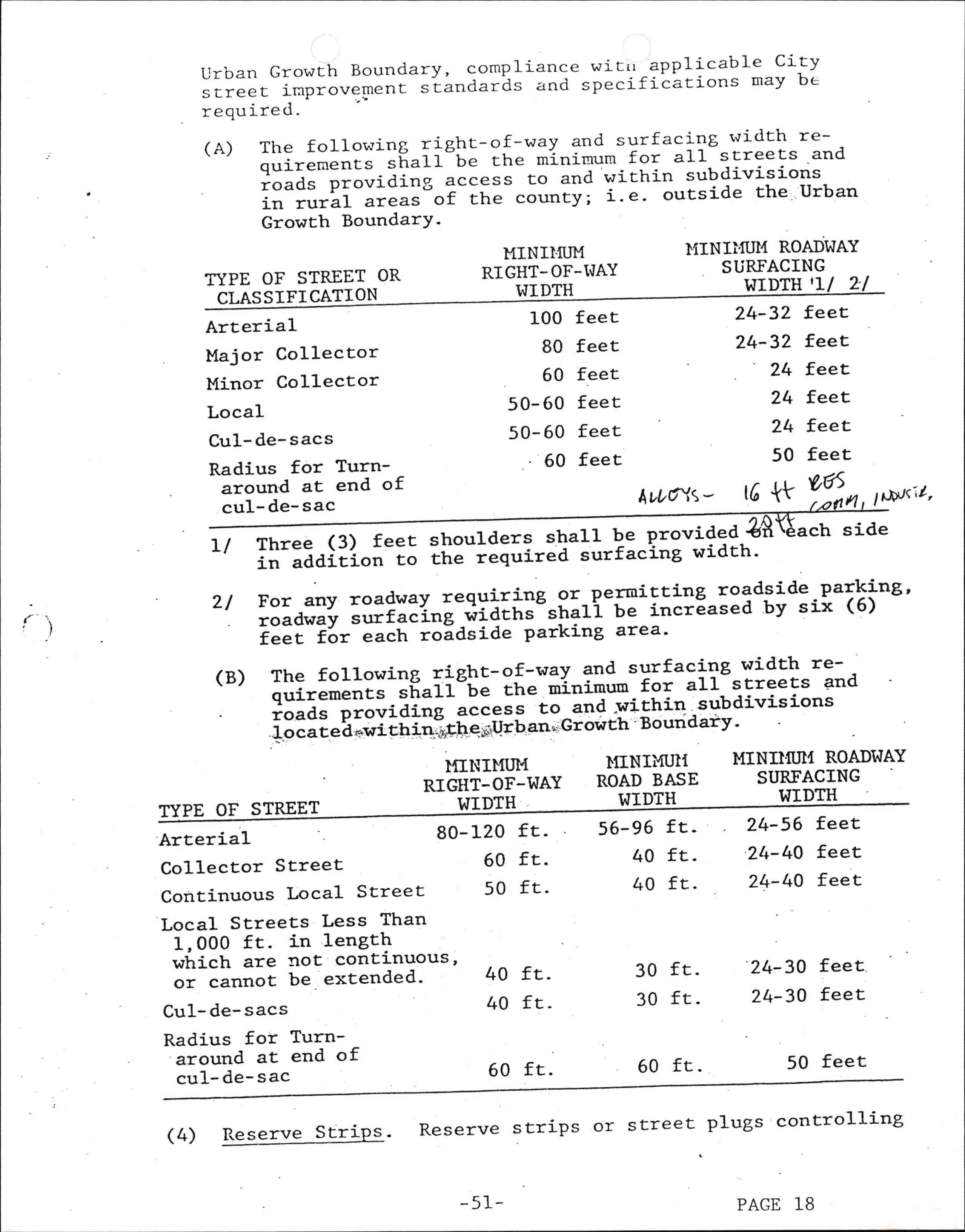
(A) The following lig|t-o.!-wa1' and surfacilt rvidrh requiremencs-sf,"rr"be tte m'inirnum for all screets and roads providing r"""""-.;-i';e yiitrin subdivisions in rural areas of the county; a'e' outside the Urban Growth BoundarY'
MINII.ITIM RIGHT- OF-I,IAY WIDTH
MINIi,flJI,l ROADWAY SURFACING
TYPE OF STREET OR I^IIDTH 'U 2t CLASSIFICATION
Arterial
Major Collector
Minor Collector Local
Cu1-de-sacs
Radius for Turnaround at end of cul- de- sac 100 80 60 50-60 50- 60 -60 feet feet feet feet feet feet
LI Three (3) feet shoulders sha
AtL6ur\-
in addition to the required 11 be Provided surfacing widt
2l For any roadway requiring 9r-permitting roadside parking' roadwav "rrt"I'io;;ia;h"""t"ti b. incrEased by six (6) ;;;; -i6r-each roldside Parking area'
(B)
The following right-of-rsav and surfacing Yig-tl-'::, ouirements shall be the mi-nimum for all streets and I#ilT;iiiii,,g acce-ss to and r'zithin subdivisions
1 o c a t e d *-i tU ioiugtt i iU' U "tt* G r ow th B o un d ary'
TYPE OF STREET
Arterial
Collector SEreet
Continuous Local Street
}{INII.llJM RIGTIT-OF-WAY WIDTH 80-120 fx50 ft.
Local Streets Less Than 1,000 ft. in length which are not continuolJs, or cannot be. extended'
Cu1- de- sacs
Radius for Turnaround at end of cu1- de- sac
side h. MINU{IJI{ ROADI^IAY
(4) Reserve Strips. Reserve strips or street plugs controlli-ng
(s)
3ccess to streets vril1 not be- apProved unless deemed necessary by if," Conrnission for'ttre protection of public safety and welfare-
Alignment.Allp.roposed.sEreeEsshallbeinalignmentwith exiscing streets- bv continr]liii;: ?I 5l: cencer-lines thereof' offsetstreetalignmencre-sulciqgin...T,'intersectrionsshall have a minimum diicance "t-ZOO fEet between the centrer-lines of opposite ,t=""i= of approxi.at"ty the same direction unless prohibited by topogt"'6icaf feiucres' 'however'' in no case, shall an)/ center-}in'e'"ii".t of less than 100 feet be p.t*iti"a.
(6) i'.*:" uffi i3 i3ix " :'iii*+i;:iE''
Ii=ll.E"Hlir-o"*""l."aua_ t"-IiI-u"""a"iv or the lubdivision or parEirion ;; ;i;;-i"",rrlioe"g.;a-;nd 'streeEs mav be aP-oroved without a turn-aror.rrd- Reserve strips and street plugs H:;"; l"qiiii.a to presetr"-it"--objectives bf street extensions'
(7) lntersection 1es. SEreets shal1 be laid out'to internear to rig a1 ht angles as Practical, exceP shal t sect at es as angLe. In no case 1 where topograPhy Te te angle be qui les res esser less there is a the acu s than 80 degrees un arterial or colLector street eciaf intersection design. An at least 100 feet sP tersectlng with another street'shall have in the intersection unless topograPhY of tangent adjacent to ce. other streets, excePt alleys, requires a leiser distaneet'of tangent adjacent to the shall have at least 50 f lesser disEance(_ ) intersection unless toPograPhy requires a at any one point The intersection of more than two streets will not be aPProved'
Street. Ilal-f streets, while generallY not accePtabIe,
(B) HaIf tiaL to-the reasonable develoPrnay be aPProved where essen artition when in confo:mity ment of the subdivision or P e regulations and when the with other requi Planning Coumiss renents of thes actical to require ion finds it will be Pr e adjoining ProPerty the dedication of the other half when th is divided. I{henever a half street is adjacent to a tractr to be divided, the other half of the street shal1 be provided uay be- r,rithin such tract. Reserve striPs and street PLugs required to Prese:.ve the obj ectives of half streets'
(e) Cul-De-Sac- A and shall have building sites cu1-de-sac sha a minimum 60 f cu1-de-sac shall be as -slort as -possible "-**i*", r".Et i of 600 fg"t and serve for not rnore "Ei;;.- i8 dwetting unit": -1 l_1 rerminar. *iiil""-"ii""f"r Eurn-a;ound with eet radius-
(10) StreetNames.ExcepgforextensionsofexistingstreeEs, no streetr ,,"o,"-"t"il b",".i-*t,ictr-wi1f duplicite- or-be confused witt -til.-rr","-oi "" existing- streLtin the city or county- streei--n""t"i "tta i*u;;;-;h;11. conforrn to the estabiished pattern in at."Hli-t.,at-"ttt11 be subject to the ;;;;;;;i- "r tn. Pt"nning cournission' and Curves. Grades shal1 not exceed six percent
( 11) Grades
on art.erials, ten percenE on collector streetrs or 12 percent on other streets. Cencer line radii of ctlrves sha1l nor be 1ess rhr; 300 feet on major arterials , 2OO feet on secondary arCeiials or 100 feet-on other streeCs, and shall be to an even-Een feet. Llhere existing condicions' Parcicularly the topograptV,-*"["-ia othe.vise impractical Eo provide buildable sitls , the Planning Co-umission may- accePt steePer lrades and sharper curves. fn flatareas, allowance shall be made for finished street grades having a minimun slope, preferable, of at leasc 0-5 Percent'
(Lz1 Streets Ad acent to Railroad Ri c-of-Wa tr{herever the ProPose right-o on conta ,ns or s acent to a railroad f-way, provision maY be required or a street aPProxinately paralle1 to and on each side of such right-of-way at a disEance suitable for the appropriatse use of the rlitrbaa. The distance land betvTeen the streets and the sha1l be deternine d with due consideration at cross streets of the minimun distance require and to d for approach grades to a future grade seParation planting provide sufficient depth to allow along land the railroad right-of-way. In the case screen strip of noE less than EwentY-five (2s) of a railroad, a 11 be provided along en th h railroad right- feet in width sha suc of-way for screen Planting betwe e railroad and reii-dential lots - Wren such paralle1 streets are less than eightY (80) feet from a freeroaY or parkwaY , d the intervening ProPerty shall be held or developed, 8D used only for Park or ets that thoroughfare PurPailroad oses. Such Parallel streets to stre cross a r sha1l be located at sufficient di-stance from such railroad to nake Provi-sions for any Possible grade separations on the cross streets '
(13) ,na1 Access Streets . I,Ihere a land division abuts or '"ro"o".dcollectororarterial street, tt i"qtire marginal access streets, reverse abli depth, lcreet, planting contained tion albng the rearor side ProPerty t necessaiy for adequate-Protection I"-:""a-i"-irr"rd separation of through
con an s or Planning Comrission naY. frontage lots with suit in a non-access reserva line, or other treatuen of residential ProPerti and 1oca1 traffic.
(1"4) Al1eys. Alleys shall be provided in co"'nercial and indus#iAfai"l;i;t;, unless other Peruprlent-provisions for access ro off-stieet--i;=ki;;-"oa-f""!i.g facilities are -aPProved by rhe plannini-C"*i_""ion. The-rniniuunn widch of dn al1ey in a residenrial block when piaitea, shall be Sixteen''r'(16);i:.;.'=iiil;; sha11 be provi'ded-.in," coomercial ind industrialdistricts a"a "trafi rrot'be 1ess.: than ,20 feeX. The corner of a1I aIleys ;a their intersection wiqh streets and other alleys shall be-curved r.7iti ;:;;ai;"--"i--o"i less than ten (10) feet
(15) approval of
ess Crossin Public Lands. I'lhere the Provisions of publi sha11 c Acc of public lands , approval access requ res t .e cross be obtained of the subdivision from the agency having jurisdictio n over said Public lands crossed prior to the PrelininarY Plat-
Comris s ion
(16) Access to State IIi hwa . Where a subcirvision requires an ate Highway, aPProval shall be der from the State Highway Department roval of the PreliminarY PIat-
access aPproac obtained by th
Section 8.030- Blocks.
(1) General. into acco street wi topograph
(2) The length, width and shape of blocks shall take .r.,i-the fieed for adequate buil-ding site si-ze and ait ""a shall recognize the limitations of the v-
(3)
Size. No block sha1l be more than 1,000 feet in length 6"tr".- itt""t corrrer lines unless it is adjacent to an arterial street or unless the toPograPhy or the- location ;i-;aj"ining streets justifies an excePtion. The re""rr.ia"d mlnimum len[th of block along an arterial street i;-1;800 feet. a bloEk sha1l have sufficient width to ;;";ia;- for two tiers of building sites unless topography b= rhe locati;; of "a5oining streets justifies an excePtion' Easements.
(A) Utility Easements. Easements shall be provided. a1o-n8' ;;;p;tly lines where necessa\l -for the placement ofLr"lh"rt or underground utilities-and where necessary io provide the subdirrision withelectric Po\rer' com'uunicari"., i""ifities' .strget - lighting, -se$'er lines' water lines,-i." linei'ior draina[e.. Such easements shal1 be label.a ;i"6fic Utility'Easement" on Et-re-preliminl{yand finat- p1"Ll-tney shail be arleast L2 feetin width and cenr.rll-o11 f"i'ri""s where pos-sibIe, excePt for utiJ-ityP;i; t"yiiq" easements which TaY be- reduced to ;il-i6i 'f;;a rn-widttr and eas6menrs afo5r' rhe- rear of lots aa5acent-to unsubdivided land which-may be reduced to 10 feetin width
(B)
Drainase. Tf a subdivision is traversed by a water course, slrcn "" " drainage walr channel,, or stream' there shal1 be provided a storil-watlr easement or drailage ;fih;_;i-ir"y ;;i"r*ing substanrially with rhe lines of of the water .orr"", ald such further width as will be "a.g;"..-i;; the purpose. Streets or parkways Parallel to uajor water courses or drainage wayi may be required'
(c) Pedestrian and Bic eWa c€, a p str an or to connect to a cul-de-sac or usually long or oddlY shaPed appropriate circulation -
Section 8.040- Buildins Si-tes -
When desirable for Public bicycle way may- be required to Pass through an un-blocic or othe::wise Provide
(1) Size and S The size, width, shaPe and orientation of u S tes sha1I be approPriate for the location of the land division and for the tYPe of develoPmen t and use conand shall be consis tent with the residential lot ions of the zoning ordinance with the following
t.emplated, size provis exceptions: toa e subdiv E i prior to Commission aPP
:
(A) In areas that will not be served by a public sewer, minimum Iot. and parcel sizes shall permit _compliance with the rtiquirements of Ehe Departrment- of Environmengal Qualiry 1an<i/or Healch De_partment), and shall take into consideration problems of- sewage disposal, parEicular:ly ;;;;i"*s of .oil strrucEure and waEer table as related to seot"ge disPosal bY sePEic tank
(B)
where properEy is zoned and planned foilbusiness or industii"i ,rs", other widChs and areas may be -per- mitted at the discretion of the Planning cgmmission. D;;;h-""a widrh of properries reserved or laid our for cornmercial and indirstrial purPoses sha1l be adequate to piovide for the off-street service and ;;;iiil-faciiicies required bv the tvPe of use and development contemP laEed-
Q) Access. Each lot and parcel sha1l abut-uP-- than an alley for a wiith of at least 50 f on a street other eet.
(3) Throu Lots and Parcels. Through Iots and parcels shal1 be .avo , excePt dential re are essential to Provide separation of resi develoPmen tial t from major traffic arterials or adjacent non-residen activities or to overcome specific disadvantages of t oP 1 ography and orientation. A planting screen easement at there sha1l be no line of building s incoupatible uses.
east ten (10) feet wide and across which right of access may be required along the ites abutting such a traffic arterial or other
(4) Lot and ParceI Side Lines. The lines of lots and Parcels, as 1 rr:n at right angles to the street t that on cunred streets theY shall ar as s Prac €, S uPon rehich they be radial to th face, exceP e curve.
(s) Division ROW Drai Wa No lot shal1 be divided bY. o t county, city or other taxing or service district, or by the right-of-way of a street, utility line or d services. rainage walr or bY easemen t for utilit ies or other
Section 8.050. sites sha1l confo:m ditions -demonstrate
Gr of Buildi Sites. Grading of building unless physicat .con- to o o 6 f stan r the proprietY o other standards-
(1) Cut slopes sha11 not exceed one foot vertically to one and onelhalf feet horizontallY
(2) Fill slopes shall not exceed one foot vertically to two feet horizontallY
(3) The character of soil for fill and the characterisitcsof 1;a; and parcels made 'usable by fill shall be suitable for the PurPose intended
Section 8.060. Building Lines-. If lPecial buildilg- seEback linesaTetob.eStabffidivision,theysha1.1beshown on the subdj-vision plat and included in the deed restpictions.
Section 3- 070. Lar e Buildin Sites- In *^vidin (, t) tracts rnto large lots or Parcels, LC at sorie uEure time are I I kely to be redivided, che Planning ssion Ttlay require that che blocks be of such size and shaPe so that cheY r.raY be so divided inEo buil ding ) sites and contain such s ite resErictions as wi1l provide tor extensaon and opening of streecs at intervals which wi11 permit a subsequent division of any tract into lots or Parcels of sraalle r size, and appropriat, individual lot building location restrictions.
Section' B. 080. Land for Public P oses. If the CountY has an incerest in acquiring a Port ono a proPose subdivision for a Public PUTPose, or if the CountY has been advised of such interest bY as chool district or other Public agency, and there is reasonable assurance that stePs will be taken to acquire the 1.and, then the Planning Couuois saon may require that those Portions of the subdivis ion be reserved for public acquisition, for a .Period not to exceed one Year , although such area may be Platted and aPProved as part of the subdivision.
Section. S-090pondlng of surface wa higt wlter table shal beEn taken to elimina t^azard shall be just
Section 8.100-
Flood Hazards- Areas which are subject to the cffiooding caused by surface_waters or i-;;i [; i"Uai"iJ"d'u"tif necLssary rneasures have te the hazard-it""ivta' The exist-ence of such ;;;; for disaPfroval of the ProPosal'
(1) Individual wells: In any development where individual wells are proposed, lhe "rUalria.i "t,"if furnish evidence thac a safe and potable watei-supply occurs on the developnrent i3 adequare fi#i;y"Iii-q;;ii;i ior domesric use to serve the develoPment-
(2) Couununity domestic water supgly system: In any development where a comrunity wat;;-";Piriy-"yii"* i" requiied or proposed' plans foi-tt," ""id ,"r"r-;Gpiy iyst"* shall be submitted to and approved by ttre afpr"prilt6 state or federal agency'
(3) A comnunity wate-r supply.system shall be required where 1ot sizes are less than "it'(li acre or whele Potable water sources are ax depths l=."L"i-ttrn 500. feet, excepting land Partitioning.
Secrion 8.110. Solid tlaste. It sha11 be necessary for the subdivider ro provide an- acce-pffiiE *"rt " of disposal of solid waste generated on the develoPnent'
Public utilit es or s, a p feas ib1e.
S'ection B -LzOaverage one (1) acre underground wherever . In subdivisions where lots ii"-i".i1ities Provided shal1 be Water 1y.
Seccion 9 .010requirements, iqPrg a iequirement of th his own oPcion, sha
I rovement Procedures. In addicion ro other el ns ca e v a subdivider, either as vemenEs to her applicable reguf thi larions or atr is ordinance or oE s Arcicle- 1t conform to the requirements o
(1) Plan Revierv and roval. Improvemen t work shall not be refore have been reviewed and aPProved coulmence un P ans t tative thereof- Such by the CountY or a designated rePresen nse of the develoPer. review and apProval shall be at the exPe d develoPapproval To the extent necessarY for evaluation of a ProPose ment, such imProvement plansofas may be required before of the tentative P1an ubdivision or the PreliminarY development Plan of a planned unic develoPmenc'
(2) Notification- Improvement work shall not comrnence until afcer-ffi-eounry iras been ""aiii"a.and approval thereof has been grrr,M,"iia"ii'work is discontinued for any reason it shall not be t."*t.a-unti1 ,after the cotrnty is notified and ilP;;;"r-tttutJ"i-g;"i"a' The cost of such inspections "Ir'd' ,pprovals "t "rT be borne by the devel-oper'
(3) ts as PIatted. Improvemencs shalI be designed' a ll'pi.ii;e and approve!.' and plans -rl.n';h; finai-Prll at the time of letion. t an Eonstsructe 1 be filed therefore shal recordation or uPon conlp
(4)
(s) urilities. Underground utilities including but not limited . ;;;;;:-Lbleptone, r'7ater mains' water service sanitary "..o!tl'-and stormv'7ater drains ' to be j-nstreets shali-be constructed by the subdivider he surfaci-ng of the streets' to elec crossings, stalled in prior to t
(6) As Built P1ans - e "p slowing public ^improvements as built ffi wirh the counc!-Lpon compietion of the improvements, and a coPy thereof "r.'"irt," recorded with the final plat
Section g-O20. Specification for lmprovements' for specificationsSee. Appendix "A"
Section 9-030nents as required s
ts in Subdirrisions. The following iraProveof the subdivider:. ha I e nsta ed at the exPense
(1) division required division aPProval,
sIEdivasion, adjac
Streets. Streetss, including alleys and curbs ' within tI'" ent thereto, ao'tt ttto=t outside the subto be improvel--"= a condj-tion of subsha11 be impioved to specifications set
forth by Ch-- ordinance and other appl able regulationsCaCch basins shall be installed and connected to drainage faciliries in accordance r+ith specificaEions in this and ;;h;;-;pplicable regulations, and in accordance wiEh addirionai specifications imposed by the -County to meet ;;;;iiia cb.,airons. Upon tompletion of street improvements, monuments snafi-Ue re.iCablished in accordance with this ;;eil;;;; and-oregor Revised Statutes at every street intersection and all p5ints of curvature and Poi-nts ot tangency at their centerlines -
(2) 'surface Drai and Storm Sewer S stem. Drainage facilities na e on an to connect the as re re vrl- n s subdivision drainage co drainage waYs or storm seloers outside the subdivision. Design of drainage within the subdivi-sion o account the caPacitY and grade necessary to
shall take int maintain unres sub<iivision an such area-
tricted flow from areas draining through the d to aIlow extension of the system to serve
(3)
Sanitarv Sewers. Sanitary sewers as required sha11 be. in;ffi; rhe subdivision and to connecE rhe subdivision to "*i"ting mains. Desi-gn s-ha]I take into account the capacity and grade to allow f5r desirable extension beyond the subdivision.
(4)
(s)
Irlater System. Wat'er lines and fire hydrants serving each frtffi; i"-it. subdivi-sion and tonnecting the subdivisionto the serving system shal1 be installed to sPecifications and- ihl ""=ri.,g r,rater syst-em Purveyor. . The design shal1 tdke into account provisioni for Lxtension beyond the subdivision.
Sidewalks. Sidewalks may be required to be installed on at iffi-"id.-;i-;pub1ic-"t'".tandinany.specia1pedestrian ."y-*iitri"-it" "rUaiiri"ion; exceP! that in-the case of primary oi'"."oodary arterials, or-speciil tyPe industrial districts' the Plannin-g couurission may Lpprove a subdivision without ;i;.;;ik;; If-"tt.rr,"tive lealltrian routes are available ; ;;;-p;;;i-iea f;;;h;;, thatin the case of streets serving residential"i""" having single-family dwelling!- located on i;;;-;aoirrf"nt-io- iro ind oie-half or less dwellings Per gross acre, ti1; iequi_rement of sidewalks sha1l not apply, Fi""ia"a ttere-is-rio evidence of special pedestrian activity ,1ong the "streets involved
(6) Da! le Routes system o Coranission rnay lanes within s
. If appropriate to the extension of a cle routes, existing or planned, the P-1anni18 -;;q;i;;-the instalfation-of separate licycle tiedts and separate bicycle paths'
(7) Street Name Signs. Street name signs :!111^P:.,}t'"talled at \'' ; t interseccaons. One str6et sign shall be provided at the intersection of each street- Two sEreet signs shalI be provided at four-roay intersections
(8) Street Lights. Street lights- sha1l be j-nstalled and shalI be served from an undergrEund source of supply as feasible-
(e)
Section 9.040. rovemenfs in Partitions. The same inProvements r,raY be required to e installe d Eo serve each building site of a part icion as is required of a -subdivision-
Section 9.050. roval of I rovements be approved by a CountY ctor PrLor to ac All costs of insPection sha I be Paid for by
Section 9-060. Aqc tance ofI rovements receive Preliminary accePtance fer pect improvements'are constructed. Final accePtance the CountY within one Year after construction i
Other. The -eveloper shall r'rake neces :y arrangemglts wlEE-ucility companies or other -persons or corPoratrons affecced for the installaiion of^ underground lines and facilities - ElecCrical lines and othei wires, including but not limited to comraunicacion, streec lighcing-and cable Eelevision, shaIl be placed underground as feasible. A11 imProvements ceptance bY the Coun the develoPer. Improvements shall at the time the sha11 be considered bY s comPleted.
Section 9 .070- Buildi Permits. No building Permit shall be issued uPon lots to rece ve an rved by sanitarY sewer and wat,er se uant to this ordinance unless
quire lace Purs dse d sha11 be comP leted, in service and sale and occuP of any bui ancy arti
service as irnProvements re an rviceable. A11 imProvements such improvements are in P required pursuant to this ordinance and other aPP licable regulations
Ehe County prior to the d upon a l-ot within the lopment. of impro Prior to sale and vements, the ntenance Surety Bond in an anount not of all imProvement sto guarantee approved bY unit erecte subdivision, tion, br Pl unit deve occuPancy, an as a condition of accePtance lding anned
P d County may require a one to exceed 10 rcent of -year Maithe value Peof maintenance said imProvements for a period of noE less than one Year from the date of accePtance'
Section 10.010. reement for I ovements. Prior to final a.Dproval of a subdivis onp at or parcall r t map v Ehe CountY, che subdivider shall either ins equired improvements and repair existing sEreets and other Public facilities damage d in the develoPrnent of the property or execute and file with the CountY iod whi an agreement ch required between himself and the County shal1 specifying the per vidingthe that, if iraprovements and repairs be comP leted and Pro the work is not comPleEed within the Period speci-f ied, Countyther may comP lete the work and recover the full cost and exPense, toge with court costs and attorney fees necessary to collect said amounts from the land divider. The agreeme ost of nt sha11 also provide for reimbursement of the County for the c inspection bY the CouritY.
Sec (1) tion 10.020. Bond-
TvoeofSecurity.Thelaqddividershallfilewiththe ffi",rr" t i" ful1 and faithful perfonrance agreement, to assure-tl: .t.'. tfiereof, one of the following:
a A surety bond executed by- a surety c-omPany authrized ;"-;;;;'"""t business in Lhe sgate-of oregon in a io.'o, approved by the District Attorney '
b.
A oersonal bond co-signed by at least one additional ;"[;;";;;"4;= *ict, Evidenle of financial res_ponsifiilil ;;e-;;;;"i"." "r those signing the bond sufficientto provia"-i.""onab1e assurance of abiliEy to pi""""a in accordance with the agreement'
c, Cash-
(2) Amount red. Such assurance of full and faithful 1 be for a sum aPProved bY the County -.or.t the cost bi ttre improvements and ,;-;;l"i"a engineering 1n!1, incidental -Eo.r.= the colt of county'inspection'
Pe rmance s as sufficient 'to rePairs, includi exPens€s, and to
(3) Default Status- If' the land divider fails to carry-out ffiit "-"gi.g*9r,r-".,d rhe counry has unreimbursed cosEs or exPen""" =E""Iting f-=oT such^failure ' the County sha11 call on the bond o, E""t deposit for reimbursernent - Tf the auor:nt of the bond "t ""itdeiosit exceeds cost' and expense incurred by the co,nty,ir-;h;11 ielease the remainder- If .the amount of the bond or cash deposit is less than the cost and expense irrl.ri."a- Uy- it.-C"""!y. -tt. land divider shall be 1iaLle to itt. county for the difference'
NATURAL/ S CE}i IClBUFFE,R AREAS
IcisEhegoalofCrookCounryEoensurecontinuiEyofthe open space .t 'ricr"r chac- h;t-;f;;i" existed in Crook County ' rb promoce l;il;;;" Urii"r;"ri;h#-ct" *""-made environment that are in harmot'v-*ittt the nacirt'i-f ""a"""p"-"t'd which will aid in reducing *r5ol lil.r.;;=.,rli*rl-"ii- r"r-rlri"n, making a healthier' environmenr antl enhancing anl"""ir"'oi ttJigttu"tiSe elolerty ; and Eo protect the following nacurat t""ort""r"fot thE use and enjoy*".t of future generacions:
I 2 3 4 5 6
Ilineral and aggregate resources
Iinerev sources
Fisn"Lnd wildlife habitat-: ;;;1.;i.a1lv and scientificarlY "t.r"l including desert areas
Outstanciing tt"ilit views and si
Wacer areas , weElands ' vratershe significant natural tes ds, and groundwater
7. 8. 9. 10. II. resources
Wilderness areas
Historic areas, sites' structures and objects
3:l:H?11":::'approved gregon recreation trairs
Potential and :5;;;;;e i"JEt'r wild and scenic water;;;; and state scenic water:$7ays;;i;";i;1";;;k and recreation sites L2. i)
Cultural Areas - An area charactetizedby evidence of an ethniffi'-"o"i"r";';;;-;iit,ai"tinctivetraits, u"ii"fi, and-social forms'
NaturalAree-Includesland.andwaterthaEhassubstantiallyreraindJEFEa6ral "t,"="Ji"i-".a-i" i*i"it""t 1:^l:bit"t" for plant, animar'-;;-;;ti;" lif;' These arL"" are reserved for scientifi. r"l"I;til-;;a-educational value'
Open Space - Consistsof lands u'se$ for agrLcultural or forest uses, aEd arry land lr""l'rti.t if protEcted, wourd conserve ihe above natural/scenic resources'
cenic Areas - Lands that are valued for their aesthetic S appearance and its corrrrunitY Wilde s Areas Areas where the earth e1f is a visitor of Ii e are untra[trne ed bY man, where uran hims ed land rewho does not remain. It is an area of undeve 1oP without P acter and influence, ertaining its Primeval char habitation, which is Protecte d manent imProvement or human al conditions and which and nanagedsoastoP reserve its natur rimarilY bY the forces ral1y apP ears to have been affected P ially un- gene th the imPrint of nan's work substant of nature, wi outstanding opportunities for soli tude or noticeable, has unconfined of recreation, may also contain a primitive and tyPe otherf eatures of scientific, €decological geological, or tr3
ucational, scenic or historic value.
Buffer Areas - Areas between residential and neighSoEooEs.--Troperty wirhin 9P9l^sq?ce zones q rediced rax assessnrencs under ORS- 308.740 - 308.79 che L}TL Srate Legislature. The following shall b areas: industrial ualifies for 0 passed by e buffer
1. Terrace north of Lar,ronta Road - Buffers the west and south boundaries of the Buckaroo Acres area. The natural drainage area north of crooked River Nleat Companyistheurbangrowthboundary-andshallbe r"""r.,rla-r" -" buf fer for future development to the nor Eh.
2. Ar,rerican Forest Products vicinicy - The natural drainage area-;;;..;ai;; fro*-Hudspeth'-s pond to Clear Pine Moulding or""-J""ig"Ited as proposed-lien "q"","-+T the L972 Prineville Aiea Comprehensive PIan and shall serve as a buffer between industrial expansion around American Forest Products and residential exPansion southeast of the drainage. The area east of- Hillcrest subdivision and south of American Forest Products shall be designated a buffer axea because additional residential and/or indus;;i"i developmenL here would result in additional conflict. tte norit-boundary of this industrial site shal1 ""=.r"-"" a buffer for future- residential development in that direction.
3. Ochoco Lr:mber ViciniCy - Residential developrnent along Willowdale Drive has treated a barrier for conEinuous "*p"."ion of ochoco Lurnber to the east of willowdale Orive.--ilr"=" straii U" " buffer area along tshe east and south boundaries of O"ho.o Lumber. Ochoco Lr:rrbe-r plans. to exDand on their property north of ochoco creek, but has "" pi'"i"-."--p"i;h;";-"ira alr"lop new property east of their present site.
I.latural Areas The U. S F. S . has the following- -natural areas .-d.,ffiinthenangIIInventory-cru9}-Yountain(6,630 acres), I"till Creek (15,950 ;;;;"i,,ntiag" C-reek (6,325 acres), Lookour l,rounrain ii5l)od-;;;;;);-R;;k' creek- (s,286 acres) and Broadwav (8,680 acres) for a total of 62,131 acres'
The BLM has two natural areas under consideration I9J pti*itive area managem"ni-Uortt Fork of Crooked River (lPpto*. 1,36t.J acres) and Sourh Fork of Crooked nivei-i"ppto". 34,Cig(;'acres, considered secondary porential) and oi-ttti"'g,2AO co.,"id.ted primary potential' A total 6f'fO ,640 acres prime natural area'
The Oregon Natural Heritage- Program (office in Portland) is a non-profit oiginization estaUtlshed Eo collect inventory data on remaining natilral areas in the site. Until LCDC requested data' this inventory data was reviewed only by the Nature Conser;;;y, a nati6nal non_prof it conservation orgamzation
whose privately donated resources are solely devoted to the pre- servation of ecologically and environmentally significant natural areas throughout the country. Recently, the Oregon Natural Heritage Program was funded by LCDC for publication of a complete natural area inventory of l.Iestern Oregon for the use of country p-lanning ai3encies. A similar documenE was to be funded by LCDC- for Eastern Oregon planners and published in January, L978
No site at this time should be interpreted as a mandatory area to be protected by stringent natural area requirements. Currently, Ehere are no Research Natural Areas (RNA's) designated within Crook County. The closest one being Ochoco Divide Natural Area across the lrlheeler County boundary near ]Iarks Creek Lodge. Currently a site report has only been completed for Grizzly Mountain (see appendix). However, site reports are to be included for Big Sunrnit Prairie, G. I. Ranch, Big Houston Lake and Crooked River Gorge (Palisades) in the completed inventory rePort in January. The twenty-one site preliminary inventory included in this Comprehensive Plan has been subdivided into the three categories of natural area, geological area and wildlife area. The following Oregon Natural Heritage Program sites (see Recreation: Historical: Natural: Scenic Map) mapped as natural areas are "Painted Hills" Butte (Gerry Mt. ), Powell Butte, Little Surunit Prairie, GrizzLy Mt., l^Iest Butte, Big Summit Prairie, G.I. Ranch ("Miniature Malheur"), '1lsland" in Prineville Reservoir, Gray Prairie, Twelve Mile Creek Grassland and Mill Creek Roadless A5ea.
Big Suurnit Prairie is probably the most unique of those natura-l areas. It is a large mountain meadow that was settled in the late 1800's. From a historical standpoint, the original 1og cabin school remains (built before 1897), the "nevr" Suumit Prairie School (1896 or L397); four large homes including the Lowrey Place (1885), Merritt House (1906), Summit Prairie Schmidt House (1906) and the Muddy Company Headquarters (approximately 1887) which currently are headquarters for Boston Ranch Company (current ovrner of most of Big Surunit Prairie). This prairie was also a surmrer encampment of various Indian tribes before the white man settled there. Active grazing on the prairie for nearly one hundred years has reduced herbacious vegetation below its natural capacity. However, wildflowers grow in aburrdance here. The BLM has identified one speciesof wildflower there (Long-Bearded Mariposa Lily) that is rare and has been reconmended for endangered classification.
Geological Areas - The most popular geological landmarks of Ehe cffi Butte, Rimrbcics aroind Plineville and the "palisades" of Crooked River Gorge below the Bowman dam. The Larks and Recreation and Open Space Sttrdy of Greater Prineville
Area desr-8na tes 851 acres of Barnes Butte located above cu1- tivated croP tback land and 4,156 acres of Rimrock area (incl uding 200 feet se from rim edge) for scenic preservation.
The Open Space Study addresses the rimrock from the inter-
section of EIliot Road and O'NeiI Highway, including Westwood Subdivision and Ochoco Wayside Viewpoint, to the Stearns Ranch. The report also includes rirnrocks paralleling Juniper Canyon, Combs FIat Road and Ochoco Creek out to Ochoco Reservoir. Further consideration should be given to scenic value of Crooked River rimrocks all the way to Smith Rock Road.
The BLM has also designated land under their ownership atop Barnes Butte for geological va1ue. BLM designated four additional sites for geological value as follows: I) Logan _- Butte located along Cimp Cieek (approximately 9,600 acres). This is the southern moit exposure of the John Day Formation. Bentonite is minerd from the clays- of this formation and Palentological - evidence can be discovered. 2) Eagle Rock and ridge extending west along Prineville ReserVoir (approximately 9,600 acres). This also-is designated for rockhounding value because of .two agate quarries. (See Recreation, Chapter III_ regarding, furcher rockhound sites. ) 3) Bear Creek ButEes known for mineral exploration and 4) Powell Buttes.
Geological sites inventoried by the Oregon Natuf"l_Heri tage Program inElude the following: Crooked River Gorge (Palisades) froil Stearns Dam to Prineville Reservoir (approximately 1,280 acres). This tall, narrow canyon is one of the best e_xposures of columnar, extensive and pillon (lake type) forms of lava existing collectiveIy. Near Suplee on the Weberg Ranch is an exposurE of the oldest rock- found in Oregon, believed to be 450 miilion years old. FossiI rernains also occur here. Professor Bob LawrLnce of O.S.U. has studied this unique feature; more deindings can be found on Pg. 150-15I, RTS-I; O.S.U., L974. Another site e Rock located near I'Iill Creek within rvice boundaries.
Three other sites of geological value located within the Forest Service boundaries ire Evans Creek Area, Steins Pillar and Twin Pi11ars. Twin Pillars are protected within the MilI Creek Roadless Area. Steins Pi1lar is rated high for scenic value by the U.S.F.S.; in fact, a trail to its base is a high trail construction priority.
Wildlife Value - The following sites are designatgd by oregoffitageProgramfoiwi1dlifeva1ue,1)Big HusEon Lake (waterfowl); 2)- G.I. Ranch, "Miniature Malheur" (waterfowl breeding); 3) Paulina Strutting grounds (grouse); 4) Twelve mile lable (deer and grouse); 5) Dry Creek Reslrvoir (waterfowl); 6i l,Iiley Cleek Ho.mestead (Uiras); 7)_ Mer:r.rin's Reservoir (waterfowl); and E)- Prineville Reservoir Wildlife I,lanagement area (3,360 acres managed for fish, deer and bird nesting by the DePartment of Fish and Wildlife) -
The Depa::tment of Fish and Wildlife designates the foIlowing additional sites as waterfowl nesting habitat: Crooked River from Jap Creek to Stearns Ranch, lower and upper Ochoco
tailed information of his f coqrler@of E @1{P isWhit the U. S. National Forest Se rl6
Creek, mouth of Bear Creek, t:iouth of Birch Canyon, Crooked River from irineville Reservoir through Post and up the south fork, B""t"t Creek and Camp Creek. T[e following reservoirs and wetlands are also designated as waterfowl nesEing habitat: --Bi8 Summit Prairie, LifEle Huston Lake, Fischer Reservoir, Hudspeth Reservoir, Johnson'Creek Reservoir, Lillard Reservoir, Freezeout Reservoir and Pringle FIat Reservoir. See Wildli!", -C-h"pter IX and Wildlife Map for flrther information. The Wildlife Map designates approximately 2L5,2O0 acres of crucial deer winter range. It also outlines elk and antelope habitats.
Natural/scenic buffer areas may also include Historic Areas as referenced in the following chapter and AGGREGATE AND MINERAL RESOURCES as referenced in Chapter IX, NATURAL RESOURCES. Additional features to be considbred for natutal-/ scenic value are Dry River (possibly a marker at the crossing-of Redmond Highway L26) and tde geogr-aphical center of Oregon, located near Post'
NATURAL/ SCENIC/BUFFER AREA POLICIES
Where no conflicting uses s-:enic resources shafl be cheir original character.
have been identified, natural/ managed so as to preserve
I,lhere conflicting uses have been energy, environmental and social determine designation.
7
ree areas of crooked River, namely the "palisades" low Bowman Dam, North fork and South fork shall be otected. In addition to the Green Mountain, Mi11 eek, Lookout }lountain Roadless Areas and Boardtree ecial }lanagement Area Protected by the U. S' F' S' , the e Sr:rrmit Piairie Area stratt also be given special ilsideration for p::,:tection as a natural area' 1 2 3 4 5 6 and clay the county
identified, economic, consequences shall
Agriculture, grazLng, forestry, parks-rPd recreation ,r8." -sha}1 be"consi[ered consistLnt with natural/scenic values dependent on resource carrying capacities'
Construction of impoundments or any other stream facility shal1 not reduce stream f1ow, water levels, or the - carrying capacity of down stream areas to suPP-ort fish, witdiifE, alricuiture, recreation, pollution abatement or visual aesthetics.
An equitable distribution of gravel, cinder removal sites shall be protected throughout fo . future construction needs.
Cr.;cial deer winter range and waterforvl nesting habitat ;h;ii b. prorecred and pieserved. EIk and antelope habitat shall also be piotected in accordance with Oregon Fish and l.trildlife management p1ans.
Th be Pr Cr Sp Bi co
B
Barnes Butte shall be protected against developmenc of any structures except for transmission lines or communicaEion towers, €ither by the existing park reserve zorle or by adopti one described in Study for the gre ng an open space zone similar to the
the Parks and Recreation and enS ace ater n e area.
9. Rimrocks frorn the intersection of Elliot Lane and O'l'{eiI Highv,ray, including l.Iestwood Subdivision and Ochoco Wayside Viewpoint, to Stearns Ranch; and those rimrocks paralleling Juniper Canyon, Contbs Flat Road and Ochoco Creek to Ochoco Reservoir shal1 be protected againsc man-made structures by such zoning restrictions as deemed necessary. R.estrictions addressing set-backs and building restrictions shall be applied to protect scenic values.
10. The Ochoco Creek and Crooked River floodplains lying within Ehe urban growth boundary shall be Protected as greenway by such zoning restrictions as deerned necessary.
1I. Subdivision developrnent along all streams and rivers shall be required co provide public access deerned necess ary.
L2. Buffer zoning restrictions shall be adopted for the Terrace industrial site north of Lamonta Road, American Forest Products industrial site and Ochoco Lumber industrial site. Such.regulations shall encourage park and open space development; an intermingling of conrneicial, light industrial and low density residential uses; and stringent landscaping requirements for all industrial development within such a zot1e.
13. Landscape buffers shall be provided along major arterial street right-of-ways in order to mitigate the negative impacts of air and noise pollution and the unsightliness of rapid, concentrated traffic. Such buffers can be broad-open space, change in grade, trees, etc. depending upon the level of impact to be mitigated.
Lq. "Outdoor" advertising signs as described in ORS 377.7L0 (23) shall only be allowed within conunercial and industrial zones.
15. Designated natural, scenic, or buffer areas shall serve a valid public purpose and property oriirlers shall be duly compensated for the right of public use if deemed jus tifiable.
16. Local, state and federal agencies shall coortiinate and cooperate in natural/scenic/buffer resource management.
HOUSING ELEMEI.IT - PRINEVILLE I.,IETRO AREA
It is the goal of Crook County provide a high degree of livability housing types and locations, and to sidential growth occurs in che most Definitions One T\"lo Three Four Five Six Seven Eight
and the City of Prineville to by offering a wide variety of ensure that addicional recost effective manner.
1 2 The Cicy of Prineville - is defined by aII that lies wfEhin the incoiporated city limiEs.
Low Income Households - the following figures are the family income limits as for Crook County:12 defined by HUD in }lay, L976,
Number of persons in family
Ave.
3. Low Income Households Needi Assiscance - are come ome owTrers an renters pay over twen
4. those low ty- five percent of their income for housing costs, those low income households which.are overcrowded (1.01 or more persons per r:iajor roor,r) and those 1ow incone households wtrictr intlude iubstandard housing (as defined in HUD).13
Prineville Metro Area - all statistics referring to the 'Eetro area-' (unless o therwise noted) were derived from the L977 Housing Survey where the sphere of influence for the metro area incl uded all the city as well as Crestview Addition, IIe1rose Acres, Stearns Addition, Schnoors Subdivision and 3/4 mile out tire liadras Highway.
5. Rehabilitative Units - are intermediatel y defective units le to be "suitable which are considered economically feasib for rehabilitation." Chapter 1, Section 104(b) of the Uniform Building Code addresses alterations to existing building as follows: "When additions, alterations or repairs-within any 12 month period exceed 50 percent of the value of an existing building or structure, such building or structure shall be made to conform to the
Department of Housing and Urban Development, 520 SW 6th Portland, Oregon 97204. Department of Housing and Urban Development.
requirements for new buildings or structures.,,,, Units "suicable for rehabiliEarion,, ;;;i;';i="fa include all slightly ciefe"tiru uniEs. aehabilitation of th: exislirg housin! srock wourd incrude weatherization and insuratilg progiams as werl as ottei major and minor repairs or alieratlons. These alterations t:tay or raay not bring rhe housing unit into conformance with the uni-form Building Code wlurr LtrE urlrr..
6 . Subs tandarrj Uni ts - are all those units tically de_fective (See which are Condition interof nle Ho r-ate v cr using Section).
7. Vacanc Rate - computed in.Aqfil, L977,by conracting te offices and alviding tire number of by the rotal housing "Eo.t available.
t e rea es ta vacant units
ANALYS IS OF HOUSIT{G STOCK
Hous in Stock Availab le The infornation provided b Crook unty ssessor so ce concerninghousing stock y the vealed a total of. 2,947 housing units i rechousand four hundred and twe n the metro area. Two the city limirs. and L0% are mobilapproximately ll% are renter-occupi
Vacant Units
Of those un nty-one of those units 1ie within e homes. Th its, approximately L7% are apartments e L977 Housing Survey revea Ied thar of the households are owner-occupied and 23% ed.
L977 , revealed a to -A tal 6%.
deterrrrination of the vacancy rate in April, of 13 vacant units in the metro area or a vacancy rate of .5
Condition of Housi The condition of ho ing information was extrapo ate 19 85 US Plan. rom Prineville Area rehens ive EcFniq For the purposes o t tpt9 3D, a Senera .n e survey hous ing ue was ernp 1oyed in NIaY, 72, to generally assess exterior condi tion - A11 units of the housing stock r^rere classified into one of four categories according to the following criteria established by rhe Bureau of CenstlS
Rating and Exterior Condition
A Not defective 1. New or excellent
B Slightly defective l: Slight damage to porch or sreps
L4 Oregon and In International .Building Code dustries Build L976 Edirion: Conference s irg,Division, Salem, Supplement of Buildi ng Officials, State of 0 Labor Buildine Dept. of Cornmerce , 4L Oregon 97 Pg. 23.L) Code L26 310, Uniform
t
Rarin and Exterio T Condition e ect ve Sma v II cracks in w 2 3 Broken gutters or downsPouts nt. alls, plasfer or chimneY
C IntermediatelY De fective : five or more defects
1. Holes in walls
2. Open cracks
3. Missirrg r^ratdrial over 4. Rotten window sills, 5. Deep wear on stairs
6. Poor or no foundation one or more intermediate defects; small atea of wall, roof frames
D Cri or 1. 2. 3.
tically
DefecEive: one or more critical defects; five nore interrnediace defecEs
Sagging walls or roof
Holes, open lr".t", -missing *'9:11"1 over large area
Damage bY storm or fire unrePaired
AlgTTupdateoftheconditionofhousingsurveywascon-ducred by .o.,"rrf t"tion with-th"--ity-lounty flitding Official ;;-;t ii.id "t".ti.e those unitsin doubt'
Inthemetroarea,approximatelyL4%ofEhe-tocalnr:mberofunits are in substandard """aiti"" (inceimediately orcritically defective). 6;;;;i;"i"rv i6"L of th" to-tal nr:rnbei of units in rhe metro area- are in , .a"Il'"""it"Uie for rehabilitation' Those unirs which wourd be erigibie t"i-a"*"riii""-inclucJe approximately 6"/" of the total households '
Evaluation of Hous Need housing sto n nee o re priviledged households in which and (3) lack of housing suPPlY
- Housing need consists of (1) rit;;i;; 5r dernolition ,- (2) trnder- -E"" much income goes for housitg' to meet the demand.
Information derived frorn the condition of Housing st'gl indicares rLrat within the "it,, lf g gnils (L3% of the total) axe in substandard condition.'e'i6."r- "i olg unirs wirhin Ehe city or Zt% of the total unit" ,t.-;;i;"tle-for rehabilitation" According ro.tri-;;.-study ,'lfi-;iL" wiitrin-tt'e citv' or 7% of the toEal are eligible for denolition'
According to the Hous-ing--S-urv"Y',?-total 683 households in the city wou1f, qualify ,:rd"i"ltUD -regul-ations for some tyPe of financiat assisirr,.".' A tot"f-of 652-trouseholds a:.e low income' paying more xil^i-ii;t" "t tt"ii-i""orl for housing. Of that rotal , 44 to,r""|,oia" "r" nJii._4";t h".,di""pp.d.pqr.sons; 25o households are elderly- 7e-;i-th6se beine ireadLa Uy elderly females; a roral of 243,f"irili"" "i" feu:al"eheaded households' In addition, 31 households "i" low income with substandard housing tt."u OAi horrseholds rePreseni ,ppto*irnately 28% of the toEal households in the citY'
Housing need basecl on short supply is determin"4 by !h" (. existing raE"ncy rate, the number of-units in need of replacement or rehaSiliration and trhe nurnber of households needed. Upon evaluation, alI three of these determinations indicate a Present and future need for additional housing. The present vacancy rate of less than L% indicates a severely restricted housing market with very few options in housing. Included in the housing stock are l-3I u.rits in-need of rehabititaEion, and L37 units unsuitable for retrabilitation and in need of demolition. By estimating population and present housing shortage,- 3o-estimate of "ppro*f*Ltlfy 550 new r;sidences wiIl-be needed by 1980.This'i.retages olt to be an additional 183 units Per year. By using an iEeal vacancy rate of 4% and adding Eo chis -cle-number of dllapidated units '(L37 ), we arrive at a shorrage of 335 units at the present time in the }lerro Area-
Detailed Housing Analysis - In order co disringuish neighborhood err^rine the distribution of household income levels and housing costs, a detailed [ousing analfsiq wa9 conrpiled. The City of Piinevilie *as divided into six residential "t.L", each as cohlsively similar as possible, and analyzed- to determine each neighborh6od's housing- characteristics. (A1I the figures pr.s".Eed here were derived from the L977 Housing Survey. )
E.ts l 2 g ?,3 o orZoB EE 3 P 2ls6
(\t(J\llO@ uJ ul Er u, 1r,l Ul (ECcECCcrcr'
-J
O\ \O rn (\ -f, \o r{ Gl Cf) cn o.f,-t r-{ O\ \O .J cfi c! (n F{ $-{ O Cr)o.$
F{ \o c?) rn tnO.$
F{ -{ (0(g IJ .TJ oo HF{ q) \.o(,] o cd !.t o) !or{ <E ! rro a 6 cro t{ .-{ <'o .o .d IJ -J cD o(B o, -c!lJ <,o IN o +J sc.) b{.,1(do C,|E t{ {q, -c F{ .c ! t.l c\t o (0 oo U.{ <'o .o .r{ F{ +J (0(,) 0Jo 1-{ B (n rd d p () H [q l'\ r\ o\ r{ I a H a Fl o H <n !f, o rd FI Fl H rd H & O{ fr{ o >-t H H (J x rd |-1 ca H
ca cn ;{ o\ cn N r\ N -t r-{ f--
F{ c.u) o! 'r{ F{rJo (dsF{O aq o.a ooP. :tr
O (\ ;< r\ -{ ;{ C\ .--{
o{ o\
"-9 r/.1
6>s r\ o=-S r{
6-e c\t 6l
N r{ r{ @ .{PU)ll o a ! tr}{ trt{ . O i t{O t{O -{ o o ([i0- (!o. I,kl{0ro
o (/)l{ 0J I E -C q s) 'O "O (I, C l'{ (U^ rJ O -(: O o a .h u) F{ -{ o 3 o-c E ..{ E u E t{ O ! O o o > o ) +' o B\' 'F{\\ oF{ oF{ .c s o a o Bo tr. r-1. Ea -o.S o o! rao o Bk Ct,l o l-{ (aGl rr o ! JJr{ l/;.Fl O O O O P (u at .r{ uo!'d<t> Lr<t> H O O O\O tr '-t E O tr 'r{ O O f X f '-t a trvo. AA trtr Eo €o € ) cd fc! F{o\ F{o\ q{N q-r tr boo 'd o c4-c .c o ' o O\O O O tr'r{ bOO tr C.l-.l "-l'lJ -C\O -C\O O 'r{ O tr'E O '-l cd O</} CJ</} 'Otr €B @)..{B(,) qq !Js) @ t{ @ H oo (!i =O obr{ )a fra pb0(0 p05(d or> oo oo 5t{o oo, 0ro otro otr9 !tr O E-o:trO OOOE.-{ &i:tr'.{>':E'.'{X 5-€Nd{"<"=*S{a-gN
The data reveals that Ehe area northwest of the core (middle north) supports the highest percentage of very low income families. Furthermore, this area contains the 6ighest p-brcentage (?2q of households headed by persons ovet 62 years of ag:9 ,19 a^high P-er;;;;g;- 1t+;6 of holslholds headed by- youns people (L6-24). The availible housing stock seems to support the needs of this income group by containfng the highest pertl.ntage-s.of both owrler and renral unirs "i-$ifiO-"i le5s per month. -This combination lends credence to Che theory tha6 tire housing stock is as much an indicator of social factors as it is a determinant.
1\ro other areas (The Heights and the Southwest) are very, similar in ttreii demographic ilakeup. _The-percentage of elderlyhouseholds i"-"1 tfi"-:i;;i " "lr"rrgl of 337"- and che-percenta8e of yorrrrg"r horrseholds is a iow 2-3%.- An average- of 807" of the fr;;;I;g stock is owner occupi"9. _ to89ther, these -two areas have the loiest percent of or"t.iorded coiditions. Indicative of the q""fiiy of iro""i"g in these regions is the_percentages of low rionthly housing c5sts. These two areas reflect the lowest per.""i"gt" of loi-cost housing u:tits. Combined, these two areas show I low percentage of 1ow income people'
A comparison of the distribution of the existing-population population'by income with the distribution of available housing Lr,it" by "ost ?;;-;;q;iiea by LCDC Housing- Goal No- 10) reveals that each area contains a coirsistantly hi[her Percentage of low income households than it does }ow cost housing units'
Area 1 Area 2 West ly1iddle North
Area 3
Area 4
Area 5
The Heishts Southwe st Middle South
7" Housing Units with costs less than $ 100 per month
Area 6
Melrose
7" Households earning $6 ,900 or lessper year
Again , aTea 2 (middle north), demonstrates the highesE. Per."rrt"gE oi'Uottr 1ow cost horr"ing'units and low income households' Located in the city core, this irea contains many older homes which due to ag. "ird use, rent at a 1ow cost and-may, 3s a con""q,r-.,.", deteiiorate more rapidly.- It is already evident from the Housine OensiiyiC""aition^MaP t!31 a relatively-high portion. of these units are in " ,".,a"or., br dilapidated condition. Second and third areas with these same demographic conditj-ons are area 1 (west)- and area 6 (Melrose) -
It is evident that the tyPe of housing- qv-ai1ab1e in these areas are fulfiiii;g a housing- he_.d and should be r:raintained as such" Aesrheiic, f,ealth and safety factors may encourage the 13r
rejuvenation of these areas, but pressure should be exerted to in",ri. that other suitable housing arrangements are made for low income families.
ted Housi Demand The following anticipated housing using the L977 population proje t forecasts and igures were comPute ions derived f rom L977 Pacific Northwest Be 1 son per household figure of 2.33. As suming that these popul cta Per-ation forecas ts hold true, the number of new housing units that will be needed over the nexc 23 yeats are as follows:15
TABLE XI
Expected Hous ing Demand for Crook County to the year 2000
Additional Units Needed 00
Metro Area (including Ad ll.,it" Needed eat the Cityditional ETT
AdditionaI Units Needed 364
Following is the existing breakdown of affordable costs of housing in thE city (based on HUD quotation of 25% of monthly income):16
$100 o $101 $201 +
r less/month $ 200/month month
34.5% of total households
26.5% of total households
39.0% of total households
If we apply these same percentages-to the projected population figures, """iririig-it"t the income diJtribution iemains basically
l5Pacific Northwest Bel1 Forecasts
16D.p".t*ent of Housing and Urban Development
the same, a rough estimate of the tyPes of housing needed can be drawn up and applied to future developments.
It is deemed important to maintain high_neighborhood quality. The City of Prinevilie and Crook County should therefore activate a rehabilitation and derqolition program Eo curtail deterioration of existing housing. The Farmers Home Administration and Depart-. ment of Hoising "rrE Urban Development offer low and moderate income families low interest loans for repair and rehabilitation work. These programs could be administered on the local level and should be^ opEn to all eligible families within the area designated for rennovation.
In addition to the Federal rehabilitation Programs described above, the City and County should adopt a housinS-code which would facilitate the procLss of maintaining a quality housing stock; such as (a) abindoned homes beyond iractical repair shouldb; a;;troyed and (U> abandoned and unsatisfactory homes capable of repair should be rehabilitated.
Low-Cost Housing - A shortage of 424 quaLity low-cost homes ($rooffittr)intheFrinevi11eMetroPo1itanAreahas been identified. The cost of building has and will continue to rise faster than annual household incomes. As Ehe L975 Annual Housing Su:rrey conducted by the Bureau of Census for HUD points out, tf,e median vdlue of owner-occupied, ginglg-family homes rose nearly 73%, from $17,000 in 1970 to $29,500 in October, L975' During the- same'period, median income for owners rose 40% from $g,ZOd ro $13,60b. Renters fared no better. From L97O to L975, median monthly gross rent including utilities increased from $108 to $156 '(44D, while the mediin annual income of renters wenr up from $6,300 to $7,900 (257") -
Mobile homes and modular housing prorride feasible low-cost housing alternatives. Nationwide codes have bggl governing constriction standards of mobile homes since 1968 tshus improving the quality of these dwellings. The codes were strengEhened in 1972 and again in 1974.
A comparison of the percentages of household income and various levels of irousing costs with the percentages of houses -available at these cost levels reveals:
TABLE XII
A comparison of affordable housing-by-household intome and present housing available-L977
25% of Household Income
$100 or less per month
$101 - $200 pLr month
$201 * per month
The tlifferences evident from this study amount to a present shortage of 424 units in the category of $100 or less per
monLh; and an excess amount of 182 units and 242 units in the $101$200 per month and g20l + per rnonth respectively.
Residential Developmencresidential areas is 3.2 unics 1.5 units / acre in Yancey to Second Street area. Compare Prineville has a marked low units/acre; Bend - 5.5 units In subdivisions outside the unics /gross acre.
The average density in the city's /gross acre, ranging from a low of a high of 4.75 units/acre in the West d with other cities around the state., residential density: Salem - 4.8 /acre and Corvallis - 7 units/acre. city limits, density averages .1-2
i'lany city residents are moving to part-time farms. This expansion has basically been concentrated in McKay Road and Quail Valley, all Eo of Prineville.
to small acreages in the county in close proximiLy to the city three areas, O'Ueil' HighwaY, some degree north of the city
Residential expansion is to be encouraged within the Urban Growth Boundary. The table on the following Page dernonstrates the amount of iand enclosed in the seven areas designated for residential expansion, and the estimated number of units those areas would be'capable of supporting at various densities. (D9velopment of the boston proplrty only, 3t an overall density of 3.5 Lnits/acre, would meLt the housing need for the city expected by 1980. )
tr.{ o & rd pa 5 z
cd (,)lz (d(J IJrts >.U6 a* oo BE E U c) o .n € a Hl ol pC E :, tJJ (,) t+{ (d00 rdo o s (, o (d tr 'r{ > -{B5t( 6 p{ h IJ6o a> o(d(J r{o J4tr ord o l{ c) t o€ utr (,)ql OFI ca H { rd d pa H a rd H H H a z frl o (J H ts & H (n H H z a rI o rra trl a t3 o
o\ooo \o t-'t -'f, @ \OOtnO\ r-{ t{ -{ oooo (n rn u1 tn -$F-Oc.) -{ -{ r\ ..f, 6l O -f,\t-f,O Gf f\ d) r{ r'l <!
f\@OrO @f\\O\O Gl-$\o@
\o (f) o r\ r{ O\ l.- 'f, r{ r{ c! cr)
tn -{ f\ '$ c\ .$ (n r\ f\ f\ tn .$ c.) O\ tn -{ (\l co ln r\ o t{ (, \- 60 t,q, .r{rJo tn tn tn ln t't c(J
co\o@ tr)-ttn F{ (\ (') or\@F\\.o -J- -f, -f, -$ O l\ .J r-l F{r{Gl(.)
@\o(flGl l,to\(f)f\ -{ -{ 6l rn (n .,f, rnNo\\o rn o\ (\l \o -{ r{ o t{ (, o rJ T{ tn tn tn r''r c 5-{<.tcn'$ H X rd *l ca H .o r-{ o .d o a a o @ o\ .,f, .{ o\ r{ a c o (t) }{ o O{ N u) FT H H H CN z frl a (, z H il HI td tl P{ o F] O{l h o & rd FA E v rcfl ,@ r{ cf) \o @ rn r{ lO f r O O C.)
-.1 O\ O\ .J Or tn f\@O F{ c{ '$
c'\.$O\(f) r.l)r{tr]O \Or{tnO rl r{ (ll
ooo\ r\ u,.| 6l 6t .f, \O
o\ trl o
HOUSIN G CONSIDERATIONS AND POLICIES
Housin Densi - The relative low density figure (3-2 units/ can be attributed to Prineville's characteristic treets - attributes which contribute to imattracting people to Prineville. There are, advanEages to continuing to Srow at the ate; higher density development is, therefore, acre) or large locs and wide s pressing visitors and however, inherent dis present low densitY r encouraged.
Direct disadvantages center around the economics_of providing additional large lots ind wide streec developments._ In addition, the costs of pioviding city services to these new developments are boosted bLcause of the- exPense of extending services additional distances. The result to the subdivider and the homeowrrer is inordinately high land values which force the buyer to spend less on housing and perhaps settle for lesser quality.
It shall be the policy of the City of P height restrictions; require street widths c demand; retain 1ow minimum lot sizes; retain yard setback requirements, excePt on princip where the seEback should be in conformance w goals; aIlow mobile home subdivisions within ttre city limits as an alternative to very hi home parks; and to establish des_ign criteria complexes which include design for open spac etc.
rineville to raise ommensurate with Iow minimr.ut front al and rninor arterials ith the transPortation and adjacent to gh density mobile for aparEnent e, parking space,
A Varie of Hous es and Locations It is necessary to pr a is o\/:L S ent vacant an r ture exPansion to al1ow for varietyof locations for new subdi'risions. In addition, cri-teria es tablished for rewiew for subdivisions that would evaluate the development's plans for providing a-variety of -housing tyPes. (apartment'complexls, 1-3 or' 4 bedroom dwellings, duplexes, etc.) arri lot sizes ttrat will meet the housing demands of the coumr:nity as outlined in this chapter.
Housing Shortage - The shortage of housing area ffi for at least five years (, in the Prineville elaborated on in The 1oca1 deficiencY this shortage is Ehe 1985 Prinevil Area sive Plan ha greatest e ect on a ure to reduce the lack of buildable lots in the area. At the Present time, there are less residential de ror-rnding the c agricultural I high costs of the housing ma situtation. than 25 lots within the metro area suitable for urban velopnnent . The maj ori tY of the vacant land sur: ity and reserved for residential expans ion is and. This shortage of lots, when couPle d with Ehe deve 1oprnent and building, is effectively tying 'uP rket and prolonging the existing shortage
It is the goal of Crook County to lower development costs while maintainiig quality developmLnt. It is recommended that a task force be formed which includes City-County Planning Com-
missions, real estaEe rePresenLatives, and the Chamber of Commerce; the task force should investigate the possibility of opening uP addiCional land in and immediately surrounding the ciCy. It is also recommended Ehat the city and county support the investigation of and application for federai and sEate programs designed Eo sEimulate housing development I
Housin Stock Rehabilitation and Demolition - Ilultiple unit high s ty tlS , spec ca v n metroPolitan area within a seven block radius of the downtown core area should be encouraged to ensure commercial facilities within walking distance of high density developments Design criteria for ap artrrrent cornPlexes of 15 or more units shall incl ude allowances for open sPa urance of c€, play areas, parking, quality construction and ens a sustaining maintenance progran by the developer and/or ovrrrer. The creation of a Housing Authority to facilita te the administration of federal HUD programs is reconrnended.
General Livability - Even though one of the main goals is- to reducffiingforthehomebuyeranddeveloper,Chere is a need to preserve and maintain the general tivability of residential nlighborhoods. The importance of adequate oPel sPace and play areas 6specialty in a higher density d9v-elopment is streiseh. Park "ie"s provided in-conjunction with residential subdivisions and the pieservation of the Ochoco Creek and Crooked River banks ""a floodilain areas as open space are also recoumended-
The need to clean up unsightly debris in residential areas which present health and'fire fiaza-rds is recognized and the following twb step cormnunity program may be instituted:
1. An all-out effort to stage a massive community clean-up, sponsored by the citY.
2. An active nuisance abatenrent program based on a realistic, workable nuisance abatement ordinance'
Desi of I.Iew Res idential Subdivisions - The quality of ed upon the follow- further res t ve ment s e AS ing criteria:
1 Consideration of the i sidential development uses. mpact and comPatibility of the rewith bordering o, neighboring land
2. 3.
Assurance that the density and vital services required in the subdivision are coumensurate with the area's Potential for future annexation.
Evaluation of the development's plans for providing a variety of housing Eypes (apartments, -L-4 bedroom hones, duplex-es, etc.) aia ibt sizLs that will meet the housing needs of the conrnunity.
4. Assurance Ehat cornmercial services (laundry facilities, grocery stores, eEc') are conveniently-located in close p.o*ii.,it;-;;-;irhin walking discance of a raulti-familv aparcment cornplex of 20 units or more'
5. Dedication of portions of a developrnent to oPen space, .o*orr-liouna,'ot uses beneficial to the needs of a subdivision when the overall density of the- residentiel' devel;;;;;; i"-z.s unirs facre or higher. This sharl be "".oopiished in cooperation ylth the cicy or counEy and mav include, but is not limited to, common storage areas,- playground areas and streets'
6. Encouragement of new subdivisions to be creaEively a""ij".t-a" planned unit developments to make best use of t5pography, natural resources, etc'
. To minimize possible conflicts betrween incompatible land uses such as r."iaerrci'"i-"Eiicufi"ru and residential-iitdystrial, bufier "II""-=fr"ff-U" establishecl ro separace conflicEing land uses, andgraduared aeciea"."-i., d"n"iiy-"i the outskirts oE the designated Ir.as shal1 be mainEained.
HENDRIX @ CH,qppELL
AITORNEYS Af, UNW i.). 716 NW. Haniman Bend. Oregon gzzol s05/589-4980 FaxBy Appointment oGI - 6lse2
CERTIFIED MAIL RETURN RECEI
October 5, L992 our file: 9756
l.lr. Alan Rappleyea. Esq. County Counsel/Planning Dir. Crook County Courthouse Prinevil le, OR 97754
re: Northridge Subdivision C-LS(U)-104-92
Dear AIan,
Enclosed is a check for S300 and the Notice of Appeal of the Planning Commission's decision on the Northridge Subdivision.
PI se call me if you have any guestions.
Gregr 1X
c: l.lr. & l{rs. Mct(iIlin
Greg Hendrix Steraen K. Chappell. P.C.
BEFORE THE CROOK COUNTY COURT
rN THE IIATTER OF C-LS(tt)-104-92 FOR TENTATIVE PIAN APPROVAL OF NORTHRIDGE SUBDIVISION BY ROBERT DURKEE ON PROPERTY LOCATED IN A SUBURBAN RESIDENTIAL, SR-l ZONE
NOTICE OF APPEAL ) ) ) ) )
case No. C-tS(M)-104-92
COI{ES NOW, James I. l{c}tiltin, Connie Mclrlillin, Jerry Crain, and Bob Green, by and through their attorney of record, Greg Hendrix, and hereby appeal the above-referenced case.
l. Appellants were participants in the hearing before the Crook County Planning Commission.
2. The decision and proposal each fail to conform to the Comprehensive plan in that the proposal does not reduce density as the development approaches the urban Growth Boundary.
3. The decision and proposal did not address the impact on the surrounding farm uses of the l/2 acre lot size abutting the Urban Growth Boundary as required by the Comprehensive PIan'
4. Required findings regardinq adequate financing for completion of the Project-rL
DATED this 2- daY of october, L992.
HENDRIX CHAPPELL
Gr H ix, OSB ys for 4 of Att el I ants
BEFORE TEE PI.AIINING COUUISSION
oF cRooK couNrY, oREGoN
IN THE ITIATTER OF C-LS(M)-104-92 FOR TENTATIVE PI,AN APPROVAL OF NORTHRIDGE SUBDIVISION BY ROBERT
DURKEE ON PROPERTY LOCATED IN A
COMMISSION DECISION SUBURBAN RESIDENTIAL. SR-l ZONE )
THE ABOVE ENTITLED MATTER having come before the Planning Commission onAugust 26, L992: and
IT APPEARING to the Commission that the above named petitioner applied to the Planning Commission of Crook County for Tentative plln approval pursuant to Crook County Land Development Ordinance No. 19r-on a tract of land approximately 116 acres in size, located at the end of Owens Road and Peters Road, one-quarter mile east of McKay Road (T L4 S., R 16 EWM, Sec. 29, TLs 101, 104 and 1600) in Crook County, Oregon; and
The Planning Commission after due consideration and being fully advised in the premises; it is therefore RESOLVED that the petition referenced above is hereby approved subject to conditions, with the findings described in Exhibit trArr and conditions described in Exhibit rrB't attached hereto and made a part of this Decisioni for the determinationr oo balance, the public welfare is served in granting such approval.
DATED TErS ..:3?.}\ll DAY OF SEPTEIIBER, Lggz.
) ) ) ) BY
PI,AIINING COUMISSTON FOR rEE COT'NTY OF CROOK LUNDQU COMMTSSION HATRMAN
GORDON MOORE COMMTSSION SECRETARY
Robert Durkee
C-LS(!r)-104-92, Decieion
Northridge Subdivision
Page 2
EXEIBIT IIATT
c-Ls (tr) -1o4-92 FINDINGS
ZONING: The property is zoned Suburban Residential, SR-1- A subdivision is approved outright in this zone under Section 3.090(1)(A) of the Zoning Ordinance. Other zoning requirements are contained in Section 3.090.
LAIID DEVELOPTIENT ORDINANCE:
Sections 3.010-3. 110 and 7.010-10.020 contain requirements for subdivision tentative plan approval. Section 3.080(3) requires that a written review and recommendation be received from the City Planning Commission prior to County Planning Commission approval of a tentative plan for a subdivision outside the city limits, but within the Urban Growth Boundary. The City Planning Commission reviewed the tentative plan on August 4, L992 and recommended approval.
COII{PREHENSM PLBN: Pages L25-L39 of the Comprehensive PIan contain policies for residential development within the Urban Growth Boundary. Page L37 states that approval of a subdivision within the Urban Growth Boundary sha1l be based on consideration of the impact and compatibility of the residential development with bordering or neighboring land uses, assurance that the density and vital services required are commensurate with the area's potential for future annexation, and evaluation of the development's plans for providing a variety of housing types and lot sizes to meet community housing needs. As density is less than 2.5 units per acre, provisions of dedicated open space as stated on page 138 will not be required.
Pages 113-119 of the Comprehensive PIan contain policies for natural, scenic and buffer areas.
Robert Durkee
C-LS(1.{) -104-92, Decision
Northridge Subdivision
Page 3
EXHIBIT TIBTI
c-Ls (u) -104-92 FTNDINGS
PROPERTY LOCATION: East of the east end of Owens Road, one-quarter mile east of McKay Road (T L4 S., R 16 EWM, Sec. 29, TLs 101 and 104 )
PROPOSAL: Tentative plan approval for the first phase of Northridge subdivision, to consist of 48 lots.
BACKGROUND: The Crook County Planning Commission granted Outline Development PIan approval for the proposed subdivision on t'Iay L4, L992, with the following provisions:
(1) A minimum lot size of two (21 acres is to be maintained throughout Phase I of the proposed subdivision.
(21 AIl lots are to be served by a community water system complying with all relevant state requirements.
(3) frrigation water rights are to be retained for the property.
(4) The proposed subdivision is to be located entirely within the Prineville Urban Growth Boundary.
(5) The proposed subdivision is to remain in accordance with the Crook County Zoning Ordinance of L978r ES amended.
On May 22, L992, the Crook County Court issued an order voiding provisions ( 1 ) .
ACREAGE: The property measures 39.53 acres. proposes to transfer 8.29 acres to adjacent land The applicant owners. The proposed subdivision phase is to measure 3L.28 acres, roads. including
CURRENI USE OF TEE PROPERIY: The property consists of land which has been used for irrigated mint production, with some vacant land with sagebrush and junipers.
AREA LAND USE: The property is bordered on the west and north by smalI (five to ten acre) non-farm parcels. Larger (40+ acre) parcels, which are vacant or in agricultural use, are located to the east, south and southeast. Hudspeth's Reservoir, which has been designated as a natural scenic buffer area by the
Robert Durkee
c-LS(u)-104-92, Decision
Northridge Subdivision
Page 4
Comprehensive PIan, is located a short distance to Barnes Butte, also a short distance to the east, designated for scenic preservation.
the east. has been
ACCESS: The applicant proposes to construct a road (Yellowpine Road) connecting to Barnes Butte Road on the north and running generally northwest-southeast through the subdivision to terminate at the southern boundary with an interim turnaround. A second road (Sugarpine Road) will branch off Yellowpine Road to serve the southwestern portion of the subdivision, and will also terminate at the southern boundary with an interim turnaround. A deadend road with cul-de-sac (Tamarack Court) will branch off Sugarpine Road. AII roads are to be constructed to County standards, with 60 foot wide rights-of-way and 24 foot pavement width. The proposed culde-sac is to have a 60 foot radius with 50 foot pavement radius.
FARM DEFERRAL: The property is on farm deferral.
IRRIGATION: The property has approximately 23.4 acres of water rights. An existing L2 inch Ochoco Irrigation (OID)/Bureau of Reclamation (BOR) pipeline enters the property from the north and connects to an existing delivery pond on the property, before continuing south to deliver water to other properties and connect to an OID Distribution Canal. The applicant proposes to fill the delivery pond and reconstruct the pipeline on the property in cooperation with OID and the BOR. The applicant proposes to transfer water rights off the property.
TOPOGRAPEY: The property has rolling topography with mostly southfacing slopes of 2-15t.
FLOOD ZONE: The property is not in a flood zone.
DRAINAGE: The property has no defined drainages, but drains generally to the south.
FIRE PROTECTION: The property is in Fire Zone II. The Fire l,larshal states that the proposed access is adequate.
UIILITIES: The property is to be served by electric, telephone, and cable television lines, which are to be underground.
WATER: Water is to be provided by a community water system with wells on the property, which is to comply with all relevant state requirements. State Heatth Division approval will be required.
SEPTIC: Sewage disposal is to be by individual septic systems. Crook County Hea1th Department approval will be required.
Robert Durkee C-LS(l'l)-104-92, Staff Report
NorthrLdge Subdivision
Page 5
LOT SIZE: Subdivision lots are to range in size from 20r000 square feet to 371800 square feet. This is in accordance with Section 3.090(4) (D) of the Zoning Ordinance. Density is approximately 1.5 Iots per acre.
WELI, TEST: The applicant stated that a weII has been drilled to a depth of approximately 900 feet on the property and a one-hour test conducted, which indicated a yield of 105 gallons per minute. He said that the well taps a deeper aquifer than that which supplies other wells in the area, and will be cased to a depth of 40 feet to avoid tapping shallower aquifers.
TESTfUONY: Three (3) persons submitted oral and/or written comments in opposition. One person's comments were that:
(1) The County Court decision permitting smaller lot sizes than required by the Planning Commission in approving the Outline Development PIan was not based on available evidence.
(21 The County Court decision is invalid because there is no legal provision for Court review of Outline Development PIan decisions.
(3) The Planning Commission should require larger lot sizes in its Tentative PIan decision.
(4) The Court decision did not overturn the requirement that irrigation water rights be retained for the property. The applicant should be required to retain the water rights.
(5) There are no plans to extend City water and sewers to serve the area in the foreseeable future. The proposed water system and septic tanks will be in use for decades.
(6) The available water supply is marginal. More deep wells will be required, which will deplete area water resources.
(7) The use of individual septic tanksr ds proposed, will endanger shallow aquifers which supply other wells in the area.
(8) The applicant is like1y to seek to develop the proposed second phase of the subdivision within three (3) years, resulting in greater impact on water resources.
The second opponent's comments were that:
(1) The state has declared Crook County to be in drought
Robert Durkee C-LS(M)-104-92, Staff Report
Northridge Subdivieion
Page 6
status, and water conservation will be required. The subdivision proposal should be re-examined in this light.
(21 More research on weII log data for the area should be done
(3) Development applications should require protection for water supplies.
(4) The weII log for the well drilled on the property shows a drawdown of 490 feet during the one-hour test, which was conducted.
(5) Nitrates in weII water are a concern in the area.
(6) A community water system is not feasible and the subdivision should be served by City water. Lab costs of monitoring well water quality would be prohibitive.
(7) The Comprehensive Plan states that groundwater supply is a major criteria for evaluation of growth policies.
(8) Some open land should be retained in the area.
A third opponent stated that the well on the property might not yield good water.
Two persons spoke in rebuttal to opposition testimony. One said that:
(1) The well tests indicate that there is adequate water for the subdivision and neighboring wells will not be affected.
(21 The use of City water is not practical and could cause greater depletion of groundwater than the proposed water system for the subdivision. City water comes from shallower aquifers than that tapped by the subdivision weII.
(3) No nitrates have been found in water from the subdivision wel1.
(4) Septic tank drainfields will be shallow and water discharged wiII evaporate or be taken up by vegetation rather than entering aquifers. They wiII not affect wel1s.
Another person stated that no nitrates have been found in other wells nearby, and that labtests of well water are not expensive.
Robert Durkee C-LS(1.{)-104-92, Staff Report
Northridge Subdivision
Page 7
The applicant presented testimony from the County Surveyor addressing the impact of the proposed subdivision on groundwater supplies in the area. He stated that:
(1) Soils on the property are suitable for septic systems, and there are no indications of a high water tab1e.
(21 No activity has taken place on the property which would adversely affect the soil by compaction, surface coverr oE saturation.
(3) There are no streams which would require septic setbacks.
(4) A septic disposal system with drainfield and replacement area would require approximately 8000-9000 square feet of suitable soils, and could be accommodated on a 201000 square foot parcel with adequate setbacks, and adequate space for buildings, driveways, and other uses.
(5) Since a community water system is to be provided, well setbacks on most individual lots will not be required.
(6) Because of the distance to wells on neighboring properties and the apparent lack of rapidly permeable soils there is not foreseeable potential for contaminating wells on adjoining parcels.
(71 Water for the subdivision is to be provided by wells tapping aquifers 600-1000 feet deep. There is no apparent potential for these wells affecting the water production of wells on other properties in the area.
(8) The limited number of wells required will allow lot design to accommodate the required well setbacks.
(9) Every lot will be tested for septic suitability prior to final plat approval. Lots can be redesigned or eliminated if necessary to comply with septic requirements.
Robert Durkee C-LS(l.l)-104-92, Staff Report
Northridge Subdivision
Page I
EXHIBIT ITBII c-Ls (M) -104-92
CONCLUSIONS
(1) A subdivision is Residential, SR-1 zone under County Zoning Ordinance.
an outright use in Section 3.090(1) (c) the Suburban of the Crook
(21 AI1 requirements for Tentative Plan approval under Section 3.010-3.100 of the Crook County Land Development Ordinance have been complied with.
Based upon the FfNDINGS and CONCLUSIONS, the request is hereby approved as follows:
(1) A11 conditions of the Outline Development PIan approval, as modified by the Crook County Court, are to be adhered to.
(21 The proposed subdivision is to remain in accordance with the Crook County Zoning Ordinance of L978r ES amended.
BEFORE THE PLANNING COI.{I,IISSION OF PRINEVILLE, OREGON
COT.TMISSION RECOMMENDATION
THE ABOVE ENTITLED I.{ATTER having come bef ore the Pl anning Commi-ssion on August 4, L992: and
IT APPEARING to the Commission that the above named petitioner applied to the Planning Commissi.on of the city of Prineville for Tentative Plan approval pursuant to the Crook County Land Development ordinance No. L9, which requires that a written review and recommendation be made by the City Planning Commission to the County Planning Commission prior to approval of a Tentative PIan for a subdivision outside the city limits, but within the Urban Growth Boundary, orr a tract of Iand approximately 31.28 acres in size, located on the east end of owens Road, one-quarter mile east of I'lcKay Road (T L4 S., R 16 EWM, Sec. 29, TLs I01 and 104) in Prineville, Oregon; and
The Planning Commission after due consideration and being fulIy advised in the premises; it is therefore
RESOLVED that the petition referenced above is hereby approved subject to conditions, with the finoings described in Exhibit rrArr and conditions described in Exhibit "8" attached hereto and made a part of this Decision; for the determination, on balance, the public welfare is served in granting such approval.
DATED THIS \5*t" DAY OF AUGUST, L992.
rr{ THE }T.ATTER OF C-LS(}.r)-104-92 FOR TENTATIVE PLAN APPROVAL OF NORTHRIDGE SUBDIVISION BY ROBERT DURKEE BY BY ) ) ) )
PTANNING COI.{T,TISSION FOR THE CITY OF PRINEVILLE
DORLESS REI coMl{IssroN
SECRETARY
GORDON MOORE ACTING SECRETARY
Robert Durkee
C-tS(tt) -104-92, Recommendation
Northridge Subdivision
Page 2
EXHIBIT'A'
c-Ls(M) -LO4-s2 FINDINGS
PROPERTY LOCATION: At the end of Owens Road and Peters Road, quarter mile east of McKay Road (T 14 S., R 16 EI^Il,i, See. 29 101, 104 and 1500). one, TLS
PROPOSAL: Tentative plan approval for the first phase of Northridge subdivision, to consist of 48 lots.
BACKGROUND: The Crook County Planning Commission granted Outline Development Plan approval for the proposed subdivision on May 14, 1992. On May 22, L992, the Crook County Court issued an order voiding the conditions of approval that the minimum lot size in the subdivision be two (2) acres and that irrigaLion water be retained on the property.
ACREAGE: proposes proposed roads. The property measures to transfer 8.29 acres subdivision phase is to 39.53 acres. The applicant to adjacent land owners The measure 3L.28 acres, including
CURRENT USE OF THE PROPERTY: The property consists of land which has been used for irrigated mint production, with some vacant land with sagebrush and junipers.
AREA LAND USE: The property is bordered on the west and north by small (five to ten acre) non-farm parcels. Larger (40+ acre) parcels, which are vacant or in agricultural use, are located to the east, south and southeast. Hudspeth's Reservoir, which has been designated as a natural scenic buffer area by the Comprehensive P1an, is located a short distance to the east. Barnes Butte, also a short distance to the east, has been designated for scenic preservation.
ACCESS: The applicant proposes to construct a road (YeIlowpine Road) connecting to Barnes Butte Road on the north and running generally northwest-southeast through the subdivision to terminate at the southern boundary with an interim turnaround. A second road (Sugarpine Road) will branch off Yellowpine Road to serve the southwestern portion of the subdivision, and will also terminate at the southern boundary with an interim turnaround. A deadend road with cul-de-sac (Tamarack Court) will branch off Sugarpine Road. Al I roads are to be constructed to County standards, with 60 foot wide rights-of-way and 24 foot pavement width. The proposed culde-sac is to have a 60 foot radius with 50 foot pavement radius.
Robert Durkee
c-Ls (t{) -10 4- 92, Recortrnendation
Northridge Subdivision
Page 3
FAR},I DEFERRAL: The property is on farm deferral.
IRRIGATION: The property has approximately 23.4 acres of water rights, which are to be transferred off. An existing 12 inch Ochoco Irrigation (OID)/Bureau of Reclamation (BoR) pipeline enters the property from the north and connects to an existing delivery pond on the property, before continuing south to deliver water to other properties and connect to an OID Distribution Canal. The applicant proposes to filI the delivery pond and reconstruct the pipeline on the property in cooperation with OID and the BOR.
TOPOGRAPHY: The property has rolling topography with mostly southfacing slopes of 2-15t.
FLOOD ZONE: The property is not in a flood zone. has no defined drainages, but drains
DRAINAGE: The property generally to the south.
FIRE PROTECTION: The property is inFire Zone II. is adequate. The Fire l'larshaI states that the proposed access
UTILITIES: The property is to be served by electric, telephone, and cable television Iines, which are to be underground.
WATER: Water is to be provided by a community water system with wells on the property, which is to comply with all relevant state requirements. State HeaIth Division approval wiIl be reguired.
SEPTIC: Sewage disposai is to be by individual septic systems. Crook County Health Department approval wili be required.
Lor srzE: subdivision lots are to range in size from 20'000 sguare feet to 37,800 square feet. This is in accordance with Section 3.090(a)(D) of the Zoning Ordinance. Density is aPproximately 1.5 I ots per acre.
TESTIITiONY: One (1) person spoke in opposition to the proposal and submitted written testimony. He stated that the County Court ruling allowing the applicant to develop Iots smaller than two (2) acres is invalid. He also stated that the proposed lot sizes will create problems with excessive qroundwater withdrawals, impacts of individual septic tanks and incompatibility with surrounding land uses.
He also stated that the proposed access is not in accordance with the Transportation section of the Comprehensive P1an. He stated that the present irrigation water rights should be retained
Robert Durkee
C-LS (!f ) -10 4- 92, Reconunendation
Northridge Subdivision
Page 4 for the property.
REFERENCE: The staff report dated July 24, 1992 is hereby refereneed.
CONCLUSIONS
1. The proposal is in accordance with the relevant sections of the Crook County-PrinevilIe Area Comprehensive P1an.
Robert
Durkee
C-tS (M) -104-92, Reconunendation
Northridge Subdivision
Page 5
EXHIBIT'B'
c-Ls(r,r) -104-92
RECOI,I}TENDATION
The City Ptanning Commission hereby recommends that Tentative Plan approval be granted for the proposed subdivision, with the fol lowing CONDITIONS:
(1) Careful consideration be given to water, sewage disposal, lot density and transportation access.
(2) Future subdivisions within the Urban Growth Boundary be submitted to the City Planning Commission for recommendation at the Outline Development Plan review stage.
BEFORE THE CROOK COUNTY COURT STATE OF OREGON
rN THE MATTER OF C-LS(M)-104-92 FOR TENTATIVE PLAN APPROVAL OF NORTHRIDGE SUBDIVISION BY ROBERT DURKEE ON PROPERTY LOCATED IN A SUBURBAN RESIDENTIAL, SR-1 ZONE
Case No. C-LS(M)-104-92
TRANSCRIPT OF HEARING BEFORE THE CROOK COUNTY PI.ANNING DEPARTMENT
DATE: August 26,1992
Lynn Lundquist: We'll call the meeting to order. We're running a little bit late tonight, my apologies for that. We'll get right on the process.
First of all, we'll handle approval of the August 12th .........
Unknown: Aren't you going to read your opening statement?
Lvnn Lundquist: I think I'll do that afterwards, l'll think l'll do that because of (inaudible), h'ave to go through the final decision.
Unknown: From last week.
Lynn Lundquist: Okay, I'll talk about that later. I'll go ahead then and.give you some inlroductory'remarks ibout the hearing. First of all, l'll. need to call the planning commission for conflicts of interest on ei=ther the final decisions or on the things on the agenda. Anyone have a conflict?
Unknown: Mr. Chairman, I have a potential conflict. !'m looking to withdraw from voting on Mr. Durkee's subdivision as I hive a stepdaughter who works for Mr. Durkee and I work directly with Mr. McMillan. And ! would like neither side to feel like I'm not able to keep the doubts and things. Therefore, I want to withdraw.
Lynn Lundquist: Okay, anyone else?
Unknown: t would like to withdraw voting on all of the four final decisions because I was absent the tast meeting. And also (inaudible) because I was not here.
1 - THANSCRIPT OF HEARING BEFORE THE CROOK COUNTY COURT
Lynn Lundquist Okay, and also, for the commission, if anyone has had overly reasonable amount of contact with any of the applicants
Also I want to tell the audience that you can call the commission if you so challenge to ...or if you so decide to challenge whether or not they have a conflict of interest or a bias on any of these things as they come along. That's open as we go through the process.
We'll begin with the staff report. ln some cases whether or not. depending that the applicanf wants it read into the hearing process. We']l .start with the proponents c19e. lbt nim or her present their evidence. Then we'll have closing comments. The proponents then wilt have a chance to respond to the opposition that was giYgn.during the'hearing. Then we'll close the hearing and then the commission will have a deliberation.
We'll run this (inaudible) loose, however we will keep control of the meeting. lf you chose to testify, we do need your name, strictly for the record and it is on tape, so that we need to know who's speaking.
Also, upon request the planning commission hearing (inaudible) will remain open for seven days for additional information if anyone requests that.
Okay with that we'll go on to the approval of the final decisions. Oh, the minutes, right. I wanted to do that first, didn't l?
Alright, for the August 12th minutes. Anyone have any corrections or additions you wanted.
Unknown: We have no corrections or additions, I move that it be (inaudible)
Lynn Lundquist: We move that second may be approved, all in favor say l.
Unknown: (All say l)
Lynn Lundquist: Opposed?
None.
Lynn Lundqulst: So ordered
(Other cases being heard first)
2 - TRANSCHIPT OF HEARING BEFORE THE CROOK COUNTY COURT
Lynn Lundquist: The next item on the agenda is a Subdivision application request number C-LS(M)-104-92 by Robert Durkee seeking commission approval for tentative plan (inaudible) for the first phase on Northridge Subdivision (inaudible) lot in SR-1 zone. The property is located east of the end of Owens Road, one quarter mile east is McKay Road, T. 14S., Fl 16 E, Willamette Meridian, SeAion 29, Tax Lots 101 and 104.
The criteria which apply to the application are contained in Zoning Ordinance number 18, Section 3.090 and ih the Land Development Ordinance number 19, Section 3.010 to 3.110; and 7.010 through 10.020. Pages 125 through 139 contain policies for residential development within the urban growth boundary and pages 1 13 to 1 19 contain policies for natural scenic (inaudible).
Does the applicant wish to have (inaudible).
Gordon: Yes I do. Well this is a tentative plan approval which is the second stage.
Lynn Lundquist: Do you have any staff report personally on that?
Gordon: Yes sir, I prepared a new staff report on it.
Lynn Lundquist: Do you wish that read in the record, Bob? Okay.
Gordon: And also, I might point out that this application required a non-binding recommendation from the-City Planning Commission because it is within the urban growth boundary. The City Plahning Commission was unableto sign a recommendation at their last me-eting beciruse they didn't have a quarm. However, at least for this particular item, however, we can still hear it. We wouldn't be signing as long as we don't sign the decision tonight which we wouldn't be doing anyway.
Unknown: So we'll have the City sign first.
Lynn Lundquist: Do you wish to testify, Bob?
Bob Durkee: My name is Bob Durkee and l'm the developer. , I don't.have any anything to add iri addition to the (inaudible) made on the outline (inaudible)
!'m hear to answer any questions you might have (inaudible) or comments.....
Lynn Lundquist: ls there any further testimony?
Bill Zelenka: My name is Bill Zelenka.
3 - TRANSCRIPT OF HEARING BEFORE THE CROOK COUNTY COURT
Unknown: Bill before you start, can 1....
Lynn Lundquist: Okay, go ahead.
Unknown: I want to know what happened in the stages for water approval to the County Court and to where we are now.
IN THE AUDIENCE
Bilt Zelenka: Just for the record, (inaudible) . We have for you, a. tentative. plan,for Northridge Estates. (inaudible) lf you recall, you made ^a (inaudible) outline development approval,'that was'reviewed by the Court and the Court c3Te up.with a (inaudible) for bidinance. The tentative plan that you have before you is based upon the Court order (inaudible).
It is my understanding that you had mailed out to you a qquple of documents (inaudikile). And that you dlso had mailed to you, along with that a copy of a (inaudible) in opposition.
(Completely inaudible)
However, what you have before you today is a plan that.has Q."pl (inaudible) at lfe order of the Crook County Couri on how they approve (inaudible)...Contrary to the letter that went adiacent witn tne decision that you got from Greg Hendrix that you decided that was' (inaudible) Section 2.030 was the Couqty L-and Develo.pment Ordinance. And I would cautibn you to look at your own Land Development Ordinance Section 3030(3) and you will find- that it is not (inaudible). He said that the letter you had before hd states ihat it is only tentative review, and that as more as a courte_sy and so forth. lf you will take a look at your own Land Development Ordinance Section 3030(3) you wilt find that the language-states a purpose of the outline developm.enlP,E! is to'niake the determination that farticular proposal complies to the County's ????? plan and the applicable zoning provision. That's what we are (inaudible) before you at the original (inaudible).
by Article 1 the appeal section
So what we have before you and the Gounty Court has already rendered the decision on the (inaudible) zone tiased upon its own reviews. of the statutes (inaudible). .flN what you have b6fore you is a pio_posal of the tentative pla.1 3L9 yo, have..(inaudible) criterii and those are d-esigned to i?? engineering, water suitability, grlow suitability and so forth and you have the -+5 or 46 lots that you have (inaugiQlp_) a.nd those tests should also have some further record that there was(inaudible) and drilled and (inaudible) water system (inaudible). And it has a sufftcient flow and (inaudible) and. it also have where y6u havb (inaudikile) and so forth because of the requirements of the (inaudible).
4 . TRANSCRIPT OF HEARING BEFORE THE CHOOK COUNTY COURT
My basis for testimony is (inaudible) criteria, and (inaudible) and would linaudible) offer ariy objection to ask the court (rest of sentence inaudible.)
Lynn Lundquist: Okay is there any more? Dave you want to testify.
IN THE AUDIENCE
Dave: Yes, I would like to address the issues of (inaudible) but I think most of the (inaudible).
The tentative plan basically fall along the state guidelines anq. is what you get when the outline develdpment plan gets appioved. But in addition (inaudible).
Same road system, same lot sizes. Same general, the same.(inaudible) all4O (inaudible) lots, 40,000 6quare feet parking lots which is consistent with zoning for this area. We have started tlie addition'al work on (inaudible) water system to the property. We have drilled a deep well (inaudible) and so it looks like (inaudible).
(Completely inaudible)
Lynn Lundquist: What is DOR's ...... do you have a reply, an official reply from
Audience: (inaudible)
Lynn Lundquist: Gordon, is that in the witness ?
Gordon: What? The letter from the DOH?
Lynn Lundquist: Yes.
Audience: !naudible
Lynn Lundquist: One other question I have Daye., your.well.is. going to be sealed as you go dowh, say you get padt the other (inaudible) is that right?
Dave: Well actually, it doesn't hit the other (inaudible) it.....
Lynn Lundquist: I though you were deeper than the other (inaudible).
Dave: Oh yeah. The usual wells out in that area are.probably..!! the. 100 to ??? toot Oeptn. This well happens to be drilled on lop of the ridgg (ina.udible). So basically that well went down through various shades of green rock (inaudible).
5 - TRANSCRIPT OF HEARING BEFORE THE CROOK COUNry COURT
Lynn Lundquist: There wasn't any water before that time?
Dave: I think there was a very small amount of water somewhere around the (inaudible) But its not enough (inaudible)
Audience: lnaudible
Dave: lnaudible.
Lynn Lundquist: Gordon, what process or what process do we need to set (inaudible).
Gordon: Well before the final plan, we have to have, you know.....
Lynn Lundquist: What's the application for this stage? What criteria do we have (inaudible).
Gordon: As far as the septic?
Lynn Lundquist Dave has given his own personal......just so we want to stay on the right (inaudible).
Gordon: Well the sewage will be by of course individual septic tanks and they haven't yet have septic tank evaluation, you know, sewage evaluation for individual.....
Lynn Lundquist: At this stage we're not required to have those?
Gordon: No sir.
Lynn Lundquist That's what I want to make sure of. !s that all right Allen?
Allen: lnaudible.
Lynn Lundquist: !s there any further proponent testimony? Any opposition testimony? Please give your name again.
(tN
AUDIENCE, NOT VERY AUDIBLE)
Jim McMillin: Our attorney by the way, still strongly disagrees with (inaudible) on the matter of the County Court (inaudible).
6 - TRANSCRIPT OF HEARING BEFORE THE CROOK COUNTY COURT
We continue to be extremely concerned about the developers (inaudible) at the extreme for the urban growth boundary. During previous other hearings, concerns over the proposed lot lines (inaudible) have been voiced_by a majority of the Cgut'ty Planning Divi'sion and the majority of the City Planning Commission and one of three county court officials.
Your lot size division toward that issue was (inaudible) by the opinions by only two county court officials. The County Court position to overturn the lot size division and the Coun[r Commission was also dohe without review of the preceding County Commission public hearing record.
Based on that fact, we can only say this ruling is virtually opinionated, bias and without regard to the fact of issues oi cohcern for (inaudible). And if you.-jus! reg.d. in our att-orney's letter of June 13 to the County Court, the Court's order itself is invalid based on the-lack of any provisions and County ordinances for an appeal or review of the outline developmeht'plan process by the County commission. As you know the outline development'plan process (inaudible). Furthermore, based .on the above county ordinance critbria, (inaudible) statutes not recognizing the outline. development .plan process, out attorndy states that the County Commission's original advisory provision bhould stand and b6 subject to County Court review only upon appeal of the County (inaudible).
We urge you to uphold the decision of larger lot sizes and or reduce the (inaudible) for phase-on'e of this'development based on lhe (inaudible) Land Use Ordinance policy as presented to you during previous public hearings.
ln the latest public hearings before the City Planning Commission, the. developer contended that the County eourt had also overturned your provision that existing water rights be retained on the property. The Court decision which incorrectly intends. to oVerturn the (inaudible) sbys'nothing about overturning lhe water rights .retention provision. We'ask that'you maintain r-etention of those existing water rights along with (inaudible).
As you know, the City of Prineville has no plans for servicing this area with (inaudible) Judging from the disfance (inaudible) we can expect to propose non-public water and sew6ge disposal systems tci be in place (inaudibte). We see a recent dramatic increase in coicern bt inve5tigation and regjulations for domestic water supply (inaudible).
I've only (inaudible) from the public at large, (inaudible). As you can see from the development well (inaudible).
The depth required to reach water, a small yield required, a lgrg.9. draw down and for slow re'covery'all (inaudible) and unfavorabl6 water sup,ply. Additional deep wells will be required ih the'area for iuture development which will only increase adverse effects on the'area water resources. Along with'the concerns for the area's (inaudible), we are very concerned for the area and such shallow surfacing (inaudible) by access by surrounding existing shallow domestic wells.
As previously stated, the major concerns for those shallow wells, is the excessive nun'iber ot inOividual septic dystems (inaudible). (inaudible) as. to believe that the developer is not likely to exerdise the purchase option and develop page two of this
7 - TRANSCRIPT OF HEARING BEFORE THE CROOK COUNTY COURT
development in three years.
Lynn Lundquist: Okay, is there any further opposition testimony?
(From audience - inaudible)
Unknown: Has there been any nitrates found in wells of this depth?
From Audience: Well, obviously there has not been enough tests.
Unknown: (inaudible) a state wide test on nitrate levels (inaudible). I have no results of those tests, but its been an ongoing thing.
Lynn Lundquist: ls there any further opposition testimony?
Bob Green: My name's Bob Green. I just want to ask a question. This well is 940 feet. What's the color of the water that you get down there?
Unknown: Clear.
Bob Green: Clear, not green. Because a number of wells when you drill down to that depth, (inaudible) produbing green water. How far down does it take (inaudible).
(From the audience - inaudible)
Bob Green: That don't mean (inaudible).
Lynn Lundquist: ls there any further opposition testimony? Okay, would the applicant oi someone wish to make a comment on some of these
(From audience - inaudible)
Yeah, (inaudible) the projected yield which is better than just based upon (lnaudible) test well indicates around'105 gallohs of (inaudible), that's for the only type of test we have available so t guess at this point (inaudible). That's q pretty deep.well. (inaudible) anq that would polentially servd somdwhere around 100 homes (inaudible). lts not unusual to draw a well out lik-e this. What happens, is you get water at that depth and has come up to static levels, up to 100 feet bi so to the surface, so there is a fair amount of
8 - TRANSCRIPT OF HEARING BEFORE THE CROOK COUNTY COURT
pressure on that water (inaudible). So when you first start that pump, the water level (inaudible) ......pu11 that water level down and stabilize (inaudible).
(continued from audience - inaudible)
Lynn Lundquist: Okay any here, I want to get (inaudible other comments? Just a minute, we'll give you a chance ) back.
(From audience - inaudible)
(end of tape)
August 27, 1992
(From audience - inaudible)
Lynn Lundquist: Okay, Jim do you want to comment again?
Jim McMillin: Yeah. My name is Jim McMillin again. !'d like to say that lagree with Dave on a lot of his points on the water situation. The problem is we don't know what the capacrty is. He'd (inaudible) just the same as we are, we got the same (inaudible).
He was talking about the well valley inside the (inaudible).
(From the audience - inaudible)
Jim McMillin: lnaudible..
! agree with Dave that taking water out of the ground in one place is probably best to (inaudible) someplace else. But one thing (inaudible). As far as septic tanks in the area, our septic tanks are individual and (inaudible).
Lynn Lundquist: Okay we'll close the public hearing. .Allan, can you shed some light on whether we can consider or not consider (inaudible).
Allen: (from the audience - inaudible)
Lynn Lundquist: Okay, any decision, whether its the first stage, second stage or third stage (inaudible)?
9
Allen: Correct. (inaudible)
Lynn Lundquist (inaudible)
(from the audience - inaudible)
Lynn Lundquist: No one has said anything. Patty whqt you thought Oh, Bill did earlier, but your, she's asking for an additional (inaudible clarify
Patty: I have a question for Allen. I didn't vote on this in the beginning first brought it before because I was involved as a realtor on the sale of it. longer involved in that at all. So can 1........ about ..... ). Would you when Bobby But I am no
Allen: lnaudible
Patty: l'm not monetarily gaining anything from a decision either way.
Allen: lnaudible
Patty: No, but my position as a realtor probably will be brought up.
Lynn Lundquist: That's okay
Allen: lnaudible.
Patty: Okay.
Lynn Lundquist So I guess your answer is no Nancy in regard to what Bill said originally.
We had talked about this (inaudible) a little while ago and thought it didn't have any bearing on it so that's why she didn't (inaudible).
Wetl water is one of the issues. I guess I confer a 3 hour test, this is a t hours test, but Bob, you want to comment on that?
Bob: I would like to make a comment about that test. As I understood it, really the well is (inaudible) $t3,OO0 to determine that water was there, W?s not, is not a requirem.ent in the preliminary plat. lts done to (inaudible) the availability of water out there. We went ahead and-diilled it. There will be extendive tests by the engineers that designed the water system. The submission of the plans to the State will be done after that
10 - THANSCRIPT OF HEARING BEFORE THE CROOK COUNTY COURT
testing is completed. There was a well.... the well was pumped for two hours at 105 gallons per minute and the well only shows one (inaudible). We were trying to make sure that we're not going to get influences of green rock and so we were a little concerned about that.
We were also at that time trying to figure out what was going to be the best setting, rather than (inaudible). We were trying to get the (inaudible) at a higher level so we wouldn't have to set the pump (inaudible). (inaudible) pushes out into the well approximately 100 feet below the surface. They did their testing at 900 feet at first and there was so much water, they couldn't lift it and couldn't push it and brought it back up and (inaudible) he's a pretty conservative kind of guy and they do.nolwant to put anything'down on this well (inaudible) that its a conservative (inaudible). But they also don't want us to settle based on their well (inaudible).
There's at that 650 foot level, we were talking about the (inaudible) of the well, and those are all things that we went into with the engineer and the final design and we start spending big bucks for that (inaudible). ! assure you that that water system is not going to be designed and approved by the State and end up being an inadequate system for that development.
Lynn Lundquist: (inaudible) You know it might not be part of this process, with the w-ell being there and the fact that (inaudible) insufficient quantity, I think we had an obligation to not go ahead and approve it again. So that's what I'm saying, Bob.
Okay, lets .......what do you think......what do you want to do?
Unknown: Bill how many houses are there (inaudible)
Bill: 57
Unknown: 50 or 60?
Bill: 57. (inaudible)
Unknown: When you look at this whole thing in perspective, we goJ.one hell of a lot of septic tanks in one little small place. This is going to be (inaudible).
Unknown: I think we're looking someplace down the road of a possible disaster 20 years from now. I don't know. - I'd like to see this whole thing go on City sewer.
Lynn Lundquist: Then the sewer is a bigger concern than the water is what your saying?
11 - TRANSCRIPT OF HEAHING BEFORE THE CROOK COUNTY COURT
Unknown: I think its biggest concern is the sewer because, you know, we've have hepatitis out of town here (inaudible) shallow wells and septic tanks that have been (inaudible).
I don't know, this is what this planning process is supposed to be about, and there's a lot of houses right there in one place. Apparently the County Coqrt. (inaudible) I thought was supposed to be a staged acreage thing to where we (inaudible) when you get closer to town so it would be closer to put in city sewer lines to that high 9qlsity, That's what I think, I think we've got an awful lot of houses there and a possibility of (inaudible).
Lynn Lundquist: Okay.
Patty: My feeling is that I think that the engineers today no. how.to. design pglter aLd mor6 efficiently than they used to 10 or 20 years ago. ldon't think they would let wells or the septics go in if they are not adequate. My feeling is to approve it as it did before.
Unknown: (lnaudible)
Patty: But I think all we're looking at in this subdivision, what 48. And I think that's all we can look at tonight. Maybe by the time
Unknown: No Patty. You've got 80 that are already there, you've ggt 5Z that are already there, you gilt another ig tnat are already there plug.the individual 5 acres pieces. So you've got they're there. Yes, we are only looking at 48, but that's 48 in addition to the ones that are already there.
Patty: Well, my feeling is that that property is in the urban groMh boundary. That was designed to be developed for housing.....
Unknown: Yes, if its going to be urban growth and its in the urban growth boundary it ought to have urban services...thats.....
Unknown: I agree with that. Because you do have to look ahead and if you get too many houses id''a small area, (inaudible) eventually have problems. because its going to keepi going that way. lts goin! to get viorse. I think you have to be really careful eve.n if.. you kndw, mayb-e even say no, that there's not going.to.be anymore than 40 is this the-first stage. Can you stof it there and we have to decide every time he reapplies whether (inaudible).
Lynn Lundquist: Gordon: Yes. (inaudible) do make that decision, isn't that right Gordon?
12 - TRANSCRIPT OF HEARING BEFORE THE CROOK COUNTY COURT
Lynn Lundquist: I would assume he probably will, well ??? is a bad word, but if he d6es, (inaudible) they will have to come fonryard then wouldn't they. Someplace they have to make a decision here. (inaudible)
Unknown: lnaudible.
Unknown: But who's going to have to pay for that? ls Mr. Durkee going to have to pay for it, or all the
Unknown: lnaudible.
Lynn Lundquist: Just what subject.....
Audience: lnaudible
Lynn Lundquist: Okay, very quickly.
Audience: lnaudible....... and remember that the urban groMh boundary (inaudible) state wide basis said that the biggest strangle hold on the cities in terms of developing than these 1 to 5 acre parcels thalare (inaudible) around there and the state.wiQe. sJugy that's coming out sayi we don't want these things to happen and they shouldn't be occurring. Ahd your lust (inaudible) the very thing that will discourage a sewer. lYste-m from goi-ng out ihere. lf domebody's sitting on a 1 to 5 acre parcel,.they're sitting.fat happf and they don't want the sewer to come out there. You think that they're going to (inaudible).
Secondly, you've got the next issue as well as (inaudible) sqy that the developer.did all the develoirment should be on sewer systems. What kind of burden are you putting on the decision (inaudible).
Unknown: Why, if you have bigger lots, then you don't have as many systems to service. lt will be the only system out there.
Audience: lnaudible.
Lynn Lundquist: concern of (inaud t'm just taking a new position at this point. I think a buffer is a prime ible)
Unknown: Well, you know the Judge and I and Bill have all been involved in this for
13 - TRANSCRIPT OF HEARING BEFORE THE CROOK COUNTY COURT
quite a few years and we see different interpretations....! helped draw that line out there and the Judge and I had different (inaudible) why it was put. _l remember itrryas put as a buffer. lt was (inaudible). But l'lost that argument in the County Court. By the time this gets to the next Court (inaudible).
Well everybody called for groMh. Growth is great until we_get one disaster. And so far, Barnes Butte Estates, the same criteria came up there. You know, there's too many houses going in one place. Well, (inaudible). lf you have a little bit of a water problem then (inaudible).
Unknown: They're not on City sewer are they?
Unknown: No they're on sePtic.
The same fears were there. Well okay ?????. But how many (inaudible) compounded into such a small area? I don't know. Mr. Durkee would like.-.....
Dave: lnaudible.
Asyou have pointed out, Barnes Butte Estates has been.in12ye.ars and there has not been any prbblems. The state presets the rules and regulations for these septic systems.' I is far more stringent today than it was 12 years ago. The requirements of those septic systems, those-are desijned and have to be approved to stand on their own. ln'other words there is no accumulative effect unless you have shallow ground water that will cause those to either merge and electrically cause a problem.
There are setback requirements from each lot, the distances and the soils. Based on the soils analysis which is very stringent, are cisterns designed. to function there. There is also a replacement system area Tequired. And if in case there is a failure ??? 99r), there is ancjther back up area in that that another system ca!. pq put in on that ?????. And I think states rules'and regulations will cover that (inaudible).
Lynn Lundquist: I want to ask Dave a. questio_n?. .ls the primary potential, for c5ntaminatioh based on the fact that we would have 25 inches of rainfall and the surface water moving and obviously a drainfield plan! cannot take all that out at that point.. ls that a potenilat for a problein? I understdnd how they are all. designed and that sort of thing. ' But what t'm'saying is, as you got a national fall in the area, is that equal tension?
Dave: The system is designed really for the watgr to..-gg.into. the gro51nd,.lts not designed to trivel through thie ground. That's why (inaudible). The (inaudtlle) is going tomdve laterally. Like you prodably got a safety factor of lwo or greater. They are not figuring that whter is eioinSj to move-laterally.away from that system. lts not going to mbve that far. That's why there really is no (inaudible).
Lynn Lundquist: I understand the (inaudible) effect. .But when you get a large v.oluryq of water and it goes down and hitd the hari1 land, then you tend to get a horizontal
14 - TRANSCRIPT OF HEARING BEFORE THE CROOK COUNW COURT
movement, I mean l'm (inaudible) enough to know that that happens. Or what I see ??? in the winter time. (inaudible) l'm trying to build a worse case scenario in my mind so I can see what that potential is.
lsn't that basically the only potential that you have
Audience: Supersaturate the soil.
Lynn Lundquist: Supersaturate the soil (inaudible).
Audience: lnaudible.
Lynn Lundquist: And that would be (inaudible).
Audience: lnaudible.
Lvnn Lundquist: ! don't know how many uses you is tne water'(inaudible) down and hits your hard ???
are talking about. But all I know then it tends to move.
Audience: lnaudible.
Lynn Lundquist: And then the other side of that, if you..get this.lateral. movement, your w-ells, if theii properly cased, should avoid this penetration. ls this a true statement.
Audience: Yes. ln the water well yes. The basic thing is that you have from some of these wells like (inaudible) area, on those real small lots (inaudible).
Lynn Lundquist: Okay. I gort of reopened this. (inaudible) Jim, is there anything...l d6n't want til cut you out of this conversation?
Jim: lnaudible
Lynn Lundquist: Sounds logical.
Jim: Yeah. (lnaudible)
Unknown: Well Mr. Chairman, I haven't real approval and that was (inaudible). For phase ly changed my mind from our original 1, ! haven't changed my mind.
15 - TRANSCRIPT OF HEARING BEFORE THE CROOK COUNTY COURT
I know its not (inaudible) or feasible, its what (inaudible).
Lynn Lundquist: Well we need to do something....
Patty: Well if I made a Motion, I don't think (inaudible) would go along with it.
Well, Mr. Chairman, I am going to make a Motion and I am going to make a motion that regarding C-LS(M) 104-92 that we approve the tentative plan as it is stated before us.
Lynn Lundquist: (inaudible) .....Gordon, can you help us out here with testimony? or Allen?
Allen: Your not going to change the (inaudible) the motion is not going to change the intensity of the (inaudible).
Basically, where its at we're approving it, you know we're not making any of what was approved for the outline, well as the outline development plan as
Gordon: changes modified there's an awful lot of houses
Lynn Lundquist: As modified. You probably ought to specify that.
Patty: As modified by the City, I mean County Court, excuse me.
Lynn Lundquist: Okay, we still have more discussions? You can all comment even though you don't vote.
Unknown: Not according to Mr. Rappleyea.
Allen: (inaudible)
Lynn Lundquist: Any further discussions?
Unknown: (!naudible)
Lynn Lundquist: Okay, question called for all those in favor say l. (t)
16 - TRANSCBIPT OF HEARING BEFORE THE CROOK COUNW COURT
Opposed?
Unknown: What if you haven't made up your mind yet?
Lynn Lundquist: You don't have to vote if you don't want to. We can understand.
Unknown: I'll sustain, because I wasn't here through the whole process of it and its a little bit overwhelming for me.
Lynn Lundquist Okay, the record shows that there are two in favor and one opposed We need a (inaudible) cast a vote....
I'm going to vote in favor. Do you want to pass this (inaudible).
I think a lot of you are doing it with reservations mostly.
Unknown: (lnaudible)
Lynn Lundquist: We can't sign it until it goes to the City. We cannot make a decision until the city .....
Unknown: That's what I thought, you can't sign it until the city signs it, but there is a (inaudible)
Lynn Lundquist: (inaudible)
Audience: (lnaudible)
Lynn Lundquist I don't know.....(inaudible).
(end of tape)
September 23, 1992
Lynn Lundquist Okay we'll go on to the approval of the decisions, final approval of the decisions which we discussed at our last meeting.
The first one is the subdivision application request number C-LS(M)-104-92 by Robert
17 . TRANSCRIPT OF HEARING BEFORE THE CROOK COUNTY COURT
Gordon, do you have anything you want to add?
Gordon: No we don't have anything further.
Lynn Lundquist: Okay ....... you didn't have any specific
Unknown: (lnaudible)
Patty?: Can we make a motion to approve it?
Lynn Lundquist: You bet.
Patty?: Okay, Mitch and I make a motion that we approve C LS(M)-1O4-92 as the commissioner's decision on this application.
Lynn Lundquist: Okay, you second that?
Unknown: I second.
Lynn Lundquist: I move to second it. ls there any further discussion?
All those in favor say l.
(r) Opposed?
(Nav)
Okay, we have....let's take that again by a show of....
Unknown: (inaudible)
Lynn Lundquist: Let's get the rest of the vote here first.
Unknown: Oh, I'm sorry. Patty?
Patty: Yes.
Unknown: Dave?
18 . TRANSCRIPT OF HEARING BEFORE THE CROOK COUNTY COURT
Dave: Yes.
Unknown: And Lynn do you want to vote?
Lynn Lundquist: I want to vote yea. Based on the fact that (inau{Q!-e) a?_ last time. (inaudible) b'ecause really this vote is basically just whether they can ??? staff prepares a final report last time.
(lnaudible)
(inaudible) don't say things behind Alex's back. Sometimes they don't talk loud dnough. We're tryinEjto have a discussion here just a littlebit.in.regard to .....so you undeistand the process, we make a decision, but its not a final decision until the staff prepares a final ieport. Basically what we're asklng for I believe is that the.staff -prepare the'report as we dsked and sometimes lthinkthatthe most critical note is before.you get to'the final decision and I guess that's what I'm basing my decision on here tonight, the fact that I think this speaks to how we had it approved the last time.
Unknown: Yes sir.
Lynn Lundquist: ls that a fair assumption?
Unknown: (inaudible) a fair assumption. We did change_....yoy know staff did change the report slightly from the way we did it the last time. Basically they had more.....
Lynn Lundquist: But what I mean is from the last meeting that we had. We had two meetings ov-er this. And we do have the City report.
Unknown: Yes sir.
Lynn Lundquist: I mean I understand where you all. are coming from (inaudible).-. lf a person r'eally believes your against something. and last time we ordered the staff to be dpproved anb I don't know wtiat the (inaudible) wq9 but..... like any hearings that we have tbnight (inaudible) even though we don't have a final report until later on, that's the timely leaE I thinX to hcipe they come to the decision you. really want-as a commissioner. Caude after that it seems to ine it is more or less whether the staff ???? prepares the report and I (inaudible) I'm trying to talk to myself I gue..ss to make sure that I get my two bits in the first time arolnd so that ..... okay, we'll go onto.....that is approved, Bob..... you're sort of like (inaudible) you're causirig me ahell of a lot of (inaudible).
19 - TRANSCRIPT OF HEARING BEFORE THE CROOK COUNry COURT
April 8, 1992 Hearing
MILT: Okay, we'll start in with the Public Hearing business. The first item is a subdivision application, No. CISM-LO4-92 by Robert Durkee seeking Commission approval of the Outline Development Plan. The property is located at the end of Owens Road and Peters Road, ll4 mtle east of McKay Road, T. 14 S., R. 16 E,., Section 2g,Taxlots 101, 104 and 1600. The criteria which apply to the application are contained in Sections 3.090, lC and 4 of the Crook County ordinance and Sections 2.010 through 4.0, 4.120, and 7.010 through 10.020 of the land development ordinance. Applicable portions of itre comprehensive plan th"t *ill be considered are oo p"g". 125 through 139 which govern the residential uses inside the Prineville urban growth boundary. Gordon, do you have any additional information for us on this?
GORDON MOORE: You should have, I believe, received a copy of a memo from Planning Department staff regarding the reqponse to questions regarding the comprehensive, the relationship of opposition testimony, the Comprehensive Plan and there's also a leffer from the Road Dept regarding status oi O*enr Road and I might also mention that the Commission toured the property this afternoon with the applicants, with the applicant and myself.
MILT: Is that all?
GORDON: Yes.
MILT: Thank you. Does the applicant or agent wish to add some testimony to this tonight? We're gonna open this whole thing back up for testimony so if you want to talk Bob, come ahead.
ROBERT DIIRI(E,E: My name is Robert Durkee, I'm the developer. The only thing I'd like to add is that after we toured the Owens Road area and obviously if we get approval for the subdivision, that as developer, any encnoachments into that right-of-way, fences, shnrbbery or that type of thing that has to be moved, and again I say that's inside that encroaching on the existing right-of-way, I would move those at my expense, in other words if fences have to be moved back a foot or a few feet or whatever is required to ao tnJroaO work that is going to be rcquired, I would be willing to do that at my expense. The idea being is that I don't want there to be any expense to the adjoining homeowners on Owens Road. Other than that, I don't have anything to add.
MILT: Bob, could you address one thing for me here? The Commission has no authority to require County nrad improvements outside of the area actually affected by the suMivision, how do we address that issue? In other words, we can't make that a condition that you do that, because it's not part of the property.
DIJRKEE: Well, you do have the authority as I understand it, in that you can require the upgrading of Owens Road, which is an off-site improvement. I would think that that would go hand in hand with any work that needs to be done in that right-of-way.
MILT: Well, it's my understanding that we cannot require off-site improvements, but we can rely on your, oh I want to say, cooperation guarantees to do those but it cannot be a binding requirement- Is that corrert Gordon?
GORDON: Yes, that's my understanding of the ordinance also.
MILT: So, it would have to be an agreement on your part to actually do those County road improvements if it is approved.
DURKEE: Could that be a written agreement with the County, with the Crook County Court?
MILT: Yes.
DIIRKEE: That would be fine.
MILT: Is there anything else at this time?
DTJRIGE: NO.
MILT: Thank you.
DIIRI(EE: Thank you.
MILT: Anybody got any questions of Bob? Guess not. We'll get back to you probably
BOB: Okay.
MILT: Anybody else wish to qpeak in favor of this application? This is the time to do it. Dave, you're looking like you want to get up.
DAVE ARMSTRONG: My name is David Armstrong and I am the engineer/surveyor for the developer and I really don't have anything to add at this time but I just wanted to make myself available to answer any questions (inaudible).
MILT: Thank you. Anyone else wish to speak in favor? OL"y, does anybody wish to testify in opposition to this development? Jim?
MCMILLIN: My nlme is Jim McMillin. I have a statement (inaudible). That's the original (inaudible) Debby.
DEBBY: Ok"y, thank you.
MCMILLIN: As you know, we're in opposition; I'm speaking for several of my neighbors; I hope they will add anything they want to or approve or disapprove of anything I say. We are rather unprepared. We thought this meeting was going to be the 22rrd from our last meeting and so if I seem unpre,pared it's probably because I am. We said, there, there was some talk about a BOR report or getting together with BOR, has that ever been done?
MILT: ft.y, Hugh Moore submitted a statement that, you know, they had not had an opportunity to review the plans ylt ara ne's been in contact with BOR and possibly next week personnel from the Bureau and myself-can meet with Mr. Durkee to discuss the requirements of that agency and during the visit of the BOR, perhaps they can also review Ochoco, oh that's a different issue, that's another apptcation, at any rate, they apparently are going to discuss it at a future (inaudible) time.
MCMILLIN: We had a field trip today too, and I wish Mr. Ltrndquist had had the chance to
LYNN: I was
MCMILLIN: (inaudible) to hear both sides of that out there but maybe you guys can pass on some of the things that we discussed out there.
MILT: I think you should raise any, but that was not an official hearing so you better raise any issues you want raised right here tonight.
MCMILLIN: I'll do that. In regards to proposed apptication CI-SM-104-92, we are submitting this document and qpeaking to clarify and reinforce the facts and issues previously presented in the public records and hearings. We continue to emphasize our concerns with the facts and issues as presented in our letter prior to the March 25, 1992 public hearings. To summarize those issues most important and critical: 1) This proposal is not in a Comprehensive Plan, priority development area, that is, served by public sewage disposal and domestic water utilities and with the improved arterial and collector transportation routes; 2) T:he high numbers of domestic wells and sewage systems proposed; 3) The failure of this proposal to use transportation access systems as planned and proposed in the Comprehensive Plan for development of this area; 4) The proposed irrigation water method and its inadequacy, as relating to the probable use of underground water sources for irigation; 5) The proposed lot size incompatibility with iurrounding land uses and area resource carrying capacities. As we know in recent times due to continuing drought conditions and added development pressures, many water tables are dropping with alarming frequency. Likewise, the frequency of area wells having to be deepened is dramatically increasing, especially in areas of added development. These facts are confirmed by area well drillers. We are aware olsix domestic wells in the west Quail Valley area which, in the past year, have become dry and been replaced with deeper wells. All of those dry wells were existing at approximately the same depth as our arpa's existing wells. In discussions with this area's Water Master, seeking restitution because of new underground withdrawals affecting our water supply would be almost impossible. Therefore the only ,oouise we will have, in the case of our existing wells being affected by excessive new withdrawals, will be to replace them with deeper wells. The cost and inconvenience will of course also be born by us. Many of the surrounding existing wells in this area are at a depth of approximately 70 feet with the static water level being at approximately 25 f*t. Our domestic water supply is noted as being surface influenced underground water due to its shallow nature. The excessive number of septic systems proposed may contaminate the area's domestic water supply. The practice of large developments such as this proposal in areas without public sewage and domestic water systems must stop somewhere. Please don't allow our most valuable domestic water resources to be diminished. In his written document presented at the March 25,'g1public hearings, Mr. Durkee stated a relationship between local and collector designated streets as identified in the Comprehensive Plan. Contrary to what Mr. Durkee would lead us to believe, the only reference to local and collector streets being determined and/or reviewed by the same criteria is for related land use. We don't question that relationship but rather this development's proposal to connect local Owens Road as a loop, thnr-loop route to minor arterial Peters Road which violates the Comprehensive plan street function purposes for locat streets. As previously noted, the first phase of this development alone would increase the residences using Owens Road by 217% without even considering the second phase loop route situation. As we have previously noted, the Comprehensive Plan clearly states the recommended acclss for this area as being by an extension of Combs Flat Road north to Barnes Butte Road and an extension of Peters Road east to the Combs Ftat Road extension. No access to this area is recommended or directed from Owens Road. Mr. Durkee also recognizes this plan, planned access in his March 25 statement. The difference is that he qpeaks of this access in terms of eventually being used. The Planning Commission is not so naive to believe that the eventual situation will, will o@ur once this area is accessed by construction and/or reconstruction on another route. Mr. Durkee states that based upon common sense and current situation his proposed access routes make a whole lot of sense. We fail to see how access that conllicts with the Comprehensive Plan by constnrcting a local designated street to allow use as a collector/arterial type loop road and accessing the area by a nonr@ommended transportation system appeals
to the common sense and current situation of anyone other than the developer. The existing crossing of the BOR-OID canal at the southern end of this property is in a location that is conducive to traffic flow eastward to that recommended Combs Flat/Peters Road extension. Additional testimony presented at the March 25 public hearing was that the BOR would probably not approve an additional crossing of the canal in that area. Both of these facts only add to the viability and credibility of the Comprehensive Plan's recommended access for this area. Also contrary to Mr. Durkee's statement, the minimum widths contained in Crook County ordinance #19, Section 8.020(3)(A) do not apply solely to newly constructed roads but to roads being reconstructed as well. Based on Owens Road clearly being outside the Urban Growth Bounday, as described in the Comprehensive Plan, those minimum widths are as follows: Rightof-way width - 50 feet; surfacing width - 24 fent, shoulder width - 3 additional feet each side. We would also like to clarify Mr. Durkee's assessment of housing densities in a mral-urban relationship. In his March 25th statement he mentioned that overall densities of 2.6 and3.2 residence per acre are considered relatively low. The key word here is overall densities. To arrive at those overall densities, many 8.0 residences per acre in the urban city are averaged with much lower number of .2 residences per acre in the fringe areas. This development is not proposed in an urban setting but at the outer limits of the growth boundary in a rural setting where the surrounding area is 0.2 residences per acre or less. We agree with Mr. Durkee's philosophy of no larger, excuse me, of larger lots at the outer boundary with densities increasing inward. Our difference is in lot sizes, more compatible with surrounding land uses and resource carr),ing capacities. Mr. Durkee also contends under item 4 of his March 25th statement that based on these hearings being only for outtine approval that detailed refinements such as lot size, road location and water systems are to be, to be provided will be handled later and with further engineering. We submit that if these important issues are not considered and disapproved or resolved by the Commission during this crucial initial phase, they will be viewed as approved from here forward. In summary we believe that, at this time, a development in this area shoutd be disapproved on the previous stated basis of: l) identified .potential problems associated with water (both domestic and irrigation) and sewage due to the proposed high number of systems; 2) the failure of this proposal to use tranqportation access systems as planned and proposed in the Comprehensive Plan for development of the area in question. If a development of some proportions must be approved in this area, we urge you to impose the following development criteria to mitigate adverse efferts on surrounding areas and more closely meet objectives and policies as set forth in the Comprehensive Plan. 1) Limit lot sizes to a minimum of 5 acres in the proposed phase I area and 2) a minimum, excuse me, to a minimum of 1 acre in the proposed phase 2 arca This criteria will reduce higher density, densities at the outermost Urban Growth Boundary and reduce negative impacts on area water resources and surrounding unique habitats. 2) Any tranqportation access be investigated and constructed as planned and proposed in the Comprehensive Plan with no access being allowed to Owens Road. We respectfully ask that the Planning Commission carefully review and consider this document as well as the previous documents, in arriving at a decision on this matter. I would like to add just a couple more things. We were unaware of the letter from Norm Thompson until today. That kind of, that hit me as a shock. I, I read these ordinances as ordinances that are passed legally for everyone ?? and I don't know how we can get around that unless we amend that ordinance. We talked out in the field today on the field trip, we talked about alt2 mrte long tangent that now has 12 residence, residences on it, fairly low speeds, it's kind of a quiet neighborhood type, type thing. We'r€ gonna have, if this thing is passed as opposed, as proposed, we're gonna have somewhere in the neighborhood of 115 residences out there, not, that's the whole total thing that could be using that road, and it's gonna be a ll2 mile long tangent (inaudible) speeds being increased thrcugh that bunch of houses. One of the comments today was that that's what traffic laws are for. Well you know as well as I do that that will never be enforced out there. We're gonna have school buses out there. I really think if that road were used in contradiction to the Comprehensive Plan, it has to be standard. We don't know of Mr. Thompson having any authority to amend the ordinances. If I'm not mistaken, that takes a County Judge signature to amend the ordinances. That's what these, what we're talking about these road widths in these ordinances, it says these are the
minimum if we reconstruct that road or construct (inaudible). I kind of got mobbed out there today on that thing; I was the only opponent and I had plenty of proponents but one thing I did notice; there wasn't one proponent out there that lives in that area; you might want to think about that. This isn't their back yard. It's our back yard. I guess in closing, right is right, wrong is wrong and this is wrong. I don't know, we've given you the legal means to protect us, we plead that you do so.
MILT: Thank you.
MCMILLIN: Thank you
MILT: Is there any questions of Jim's report? I guess not at this time. Is there anybody else wish to speak in opposition to this proposal? Yes.
HOUSTON: Yes, I would like to. I'm Blanche Houston and I live on Owens Road and lived there longer than anyone else. We purchased our place n 1949, moved there April 25, L950 and we fought this out once before n 1974. They wanted to move the urban growth boundary to Barnes Butte Road. We finally got together and called in the LCDC on it and got it stopped, we thought permanenfly on the south side of Owens Road and I think that's where it should stay and I agree with everything Jim McMillin is saying.
MILT: Thank you. Anyone else wish to speak in opposition?
WAYIYE BOBBITT: I'd just
MILT: Yes
BOBBITT: Iike to let it be known that I agree with Jim; I agree with Mrs. Houston.
MILT: Your name please?
BOBBITT: My name, pardon me, my name is Wayne Bobbitt.
MILT: Thank you.
BOBBITT: We live on the road and I just truly feel that there'll be way too much traffic, way too much water use; the whole thing is not planned out. It wasn't origrnally planned out that way; I think that there's got to be another access to that property. I can't say that I want to stop this project, that I would want to be opposed to the project, but I just feel to bring that kind of traffic in, that kind of population in on one road, one access road, over two miles out of town, through that small road, it just, to me, it just doesn't make sense. It seems to me that there's bound to be a closer rcute, like Peters, I don't know, Combs Flat Road extended through there; there's got to be something else. I just, I don't have a lot to say but I just want to agrtr- with Jim and the others.
MILT: Thank you. Bob?
BOB GREEI.{: My name is Bob Green. I just want to go on record to say that I agree with everything Jim read here. I, 5-acre lots would be more to my approval than l-acre lots. I think everyone of ui out there is really concerned about our wells. I know that's my, one of my things to think about so for this reason, I, I'm against it.
MILT: Thank you. Anyone else in opposition? Greg?
LYNCH: Greg Lynch, I appeared at the last meeting when this was initially proposed. I have property that's immediately to the north of the property where the subdivision is proposed and as I said last time, I'm strongly in opposition to the development as proposed. I think the, what's before the Commission is wholly inadequate and your consideration for even conceptual approval is premature. Couple of preliminary comments - I would say that when the criteria was drawn up for the nrles that you were gonna to be applying and I made this ?? the last time I was here; I'm not a land use lawyer and I don't profess to be one but I would say that my limited knowledge is that the ordinances under which you're operating and the rules under which you are supposed to follow give to you the discretion that you will need in order to govern effectively and make sure that the proposals that come before you with respect to the developments within the community are appropriate and in this instance, what we have is a situation where, in my opinion, we have a developer coming in and seeking to exploit the property and the landowners next to the property simply because it's inside the urban growth boundary and the zoning allows development as an outright use. I think that it's incumbent upon you as a Commission and as a govemmental body in terms of governing appropriately to look beyond the, the pure zoning aspects and ask yourself what do you know and what don't you know about this development and the impact that it's going to have, not only on the surrounding neighborhood but also on the community at large. This is a large tract of land; it's one of the premiere areas of Prineville; it's within two miles of downtown; it certainly is going to be developed some day; there's no question about that. What is your reqponsibility as a planning commission and I think your responsibility is to see that whoever develops that prcperty develops it responsibly and that means that they come before you with an organized plan for development and they answer for you all the questions that need to be answered before you even give conceptual approval. We know that we're in our, I don't know, third or fourth or even ffih year of drought. We know that we have wells throughout the community that are going dry and that are having to be drilled deeper. We also know that there's a dramatic drop in the irrigation water sc we know that water is a problem and yet we have a subdivision coming before you seeking conceptual approval, albeit initially, 30 or 40 lots, but ultimately well in excess of 100, all of which are going to be dependent on individual wells. At the same time, we have no idea what, what the impact is going to be on the existing wells and not only on the existing wells in the surrounding area but on the water table in general. With respect to what could have been done and what could have been prevented had something like a community water system been imposed, going significanfly deeper. I think it's incumbent upon a responsible developer to come before a responsible commission and say they've done a hydrology study; they can tell you that there isn't gonna be an adverse impact and this is consistent with not only the master plan but it's consistent with overall good community planning. At the same time, there's nothing that I see in the proposed development plan that makes this community that Mr. Puckett and Mr. Durkee are asking you for conceptual approval to put in to be receptive to community services once they're available; we're talking about in excess of 100 homes. We're talking about sewer and we're talking about water. We don't have the developer coming before you and sying "I-adies and Gentlemen, these are only temporary; we have a sigfficant need for housing; we're gonna put in individual wells and septics but what we're wilting to do is we're willing to put in dry lines, dry water lines and dry sewer lines so that ultimately when the city services or the community seryices are available, you can hook up". There's nothing that, that before this Commission, there's nothing demonstrated in the plan before you that shows that the developer has an interest in the community. The only thing the developer has an interest in doing is taking advantage of a rather loose set of nrles that say that, that a development inside the urban growth boundary is an outright use. That's where I think that you all have to exercise your discretion and say "wait a minute, there's too much here that we don't know; there are too many things that can go wrong". We already know that there are a sigfficant number of agencies in the community that are saying "we really donit have any iuswers right now". ??, the Bureau of Reclamation, the OID and all the neighbors have come in here and expressed ?? legitimate concerns about what's going to happen to them.
Development may be an outright use in an urban growth zone, but a developer doesn't have an unqualified right to come in and develop property irresponsibly and I would urge the Commission to again table this application until such time as you have before you a responsible development plan that answers even the most fundamental issues and the fundamental questions about a long-term impact and even the short-term impact that this development is gonna have on the community. It's not a question of a man coming in and developing it in a minimal fashion and making a profit. We're talking about what the impact to Prineville and to the Prineville residents and the Prineville community a subdivision like this is gonna have. 'Thanks.
MILT: Thank you Greg. Does anybody else wish to speak in opposition? Yes. Barbara?
BARBARA FONTAINE: My name is Barbara Fontaine. I would like to know if that's what extent?? development would have on the adjacent wetlands and what factors of the law protect those wetlands, the adverse effects (inaudible).
MILT:
Ok"y, we'll try to address that. Thank you. Anything else? This is the time to do it.
BILL ZELEI\KA: (naudible) gonna ask for neutral?
MILT: Well, I don't know. How neutral are you? Go ahead Bill.
ZELEI',{KA: My name is Bill Zeler/r;a and I live in Barnes Buffe subdivision which is just on the other side of the hill from the proposed development. I wasn't going to say much, but after listening, I'm gonna have to. I'm also president of the Barnes Butte Homeowners Associates, Association, and initially when the development came in, I also had concerns regarding the water cause we have 56 hookups on our water system and of course that's a concern to me. Qnaudibte). I think one of the things though you have to look at and I think the Commission is geared and rcquired to look at through the process that you're looking at this under right now is conceptual, is that you've got a three stage process and I think what's happened is, through a lot of the discussion, a lot of the issues, which are valid issues, and I have some of the same concerns, are not necessarily appropriate in terms of decision making at this stage of the process. I think they're appropriate in the sense that you can give direction or maybe influence a decision on it, but I don't think it's a, some of the issues that are raised are pertinent to say "yes you should or should not approve this development". Anything that regards to the Bureau of Reclamation, Irrigation District, water availability, sewer availability, any of those issues which are valid issues and I think you just went through one and gave the final tentative approval today, which was a result of an outline development approval which was Stagecoach Ranch, you will notice that you did not address all these same issues; they were, some of the, same type of issues were raised, (inaudible), condition outline or conce,ptual approval oufline onto the next phase which is the tentative plan which requires that type of level of engineering and detail work, that type of coordination with various State and Federal and local agencies, to make sure that those rcquirements are being addressed. But that's the appropriate level for a lot of those issues to be raised and that's when the engineer is really out there talking with all these various people and so forth. It's not the basis, unfortunately, and somebody, (inaudible), I think Jim ended up saying "well gee, this is my back yard, now I've got an issue" or "you know, I've got a concern" and you know this is I guess what we call i nimUy, and normally most residential developments aren't nimbies and that nimby stands for "not in my back yard". Our charge or the Planning Commission's charge under conceptual approval is to take a look at the, Comp Ptan. Does the Comp Plan provide for development? The answer to that question. How does it? What type of criteria do we look at in answering it. Do we have transportation policies or does it have access? DGs it have adequate access? Is there other, anything else in the zoning ordinance criteria? What's being proposed? Are they l-acre lots? What does the zoning ordinance require at this level? Is it l-acre for individual wells and septic tanks? I'm not a lover of individual wells and septic tanks; and I'm
not a lover of l-acre lots but those are the criteria that I think the Commission at this point is being charged with. You've got to look at those, find out what you've got in the record, what are the answers, make a decision on it. Take the concerns that are being raised and appropriate concerns and say okay, we may have some concerns at this level which is a broad, non-engineering level, submittal, and say now, give the developer directions saying ohy, we give you conceptual approval, but you've got to address these issues in order (turned tape over) approval, you've got to get the engineering done to address these, whether it's the water testing cause of the water issue, whether it's the septic or soil (inaudible) use suitability, for sewage disposal, whatever, those are the type of things that you tell the developer to go at and so I think one thing that has to be paramount, is you got to focus in on what you're looking at this stage and what's appropriate and what's appropriate to either give direction for the next stage and I think, you know, the, the issue, and I, as I-awrence walked in this morning or this evening, he asked me if I was gonna to be here to answer any questions regarding the urtan growth boundary and I think one thing that should be looked at back in the 1985 Comprehensive Plan which was approved back n L973, the urban growth boundary was probably twice as large as it is now. Then in 1978, another line was drawn and that was submitted to the State for approval under the Statewide planning goals??. (Inaudible) elevation line, it just meandered all around the area, then in 1982 a study was undertaken to actually try to delineate that line so that somebody could reasonably interpret where that line was. When we ended up coming up to that point in the area, there was a deliberate attempt to isolate and keep out of the urban growth boundary the reservoir and there was a section line or sixteenth line, whatever it was, quarter section line that was down by the dam and a 45 degree angle was shot over to the next line on the extension of Owens Road and that's how that line ended up getting developed and passed into law. There was never any attempt to isolate or split little segments of property because at that time, we didn't know exactly where those property descriptions were. There's been some subsequent surveys after that, that have probably clarified where those lines are permanently.
MILT: Thank you Bill for your sage advice and it is, some of it is pertinent. Bob, do you want to rebut this, you gotta
DIJRKEE: This is Bob Durkee; I'm the developer. Most
HOUSTON: Just a minute Bob if you would ste,p over here we can all hear you.
DuRIGE: Okay. The only thing I'd like to add is I believe that in prior testimony that I have covered both vertally and documents that I've submitted covered all of the points that I heard tonight with the exception of th" not having contact with BOR at this point. I believe that prior to preliminary plat approval that we will have to establish what criteria is going to be required from BOR to cross their, their canal. What type of improvement that needs to be. But I think that can be addressed at a later date. Also, the, prior to preliminary plat approval, once you have conceptual approval, is reasonably, reasonable at that iime, pribr to pretiminary plat, is to qpend some money, we plan on on drilling a well or wells in the area, do some pump tests, we alio plan on septic site evaluations to make sure that those concerns are met and that we're able to submit to the Commission more inforrration to help them in making their decision. That's about all I have to add. I do believe that I have developed this in a responsible manner. I did take into consideration the area and the density. That's why I proposed the density that I did. I would like to clear up one statement that was made in that there would be 200 homes there, I believe at best, at the highesf density, there will be in the neighborhood of 150 to 170. The only individual wells will be on these 26 lots. Now those will primarily be made up of 3-party wells, 3-parcels. Now this is if adequate water supply is available. Weire gonni have to drill some wells and do some checking on that, but this is what I'm proposing at this point tliat as the density gets greater below, those will, that will all have to be communily water systems and how many wells, that again depends on on the well depths and the water
that's found. This density thing is tied to the septic site evaluation and it's tied to the water availability. As we did over at Barnes Butte Estates and I think we were able to go in and drill a well to determine the water supply, and then we went forward from there past the preliminary improvement stage, approved stage. There's a lot of work that has to be done yet, and I admit that. Those are all things that cost a considerable amount of money; that's one of the reasons that this conceptual approval was designed the way it was, as I understand it. Nothing is going to get developed out there unless there's a basis for it being done and I have submitted the information you need to assure you that, that we've got the adequate water supply, we've got the septic site approvals and and met the other criteria. That's all I have to add unless anyone has any questions.
MILT:
Thank you Bob. Okuy, I think we'll go ahead and close the public testimony at this point except the Commission may ask questions of any of these parties as we go on. I'm gonna lean on Gordon alittle bit here. Could you refresh our memories as to just exactly what, woops, what criteria needs to be considered for conceptual approval? Got alittle flood up here. Cold tea. There's too much stuff on the desk here.
GORDON: In order, in order to get pretiminary approval the Commission must find that the subdivision as proposed will satisfy the intent of the land development ordinance relating to subdivision development, the intent and requirement of the applicable zoning regulations will be in compliance with the Comprehensive Plan standards set forth in the land development ordinance and such finding must include the following: the subdivision is an effective, efficient and uffied treatment of the development possibility as a project site while remaining consistent with the Comprehensive Plan relative to orderly development in land use patterns in the area; provides for the preservation of natural features and resources and 2) the subdivision will be compatible with the area surrounding the project site and will not create an excessive demand on public facilities and services; 3) proof that financing is available to the applicant sufficient to assure completion of the suMivision; 4) that there will be minimal long-term detrimental impacts on neighboring properties, natural resource quality, area livability and public services and facilities and one thing which also which must be submitted in connection with the outline development plan is an explanation of the character of the subdivision and the manner in which it is planned will be designed in compliance with the Comprehensive Plan, zordrng ordinances and land development ordinance. A statement of and description of all proposed on-site and off-site improvements, a statement of proposed financing, a statement of present ownership of all the tand included, the general schedule of development and improvements, a statement setting forth expected types of housing and other uses to be accommodated, traffic generation, population and any other information relative to demands of public services, a statement relative to compatibility with the adjoining and area land uses, both present and future and finally it states the purpose of the outline development plan is to make a determination that the particular proposal complies with the County's Comprehensive Plan and the applicable zomng provisions. A review by the Commission shall determine whether the proposed subdivision as submifed will have detrimental impacts upon the general area and that the particular site is capable to be developed as proposed.
MILT: book.
Thank you. That is a lot Gordon. I have another question for you before you close your
GORDON: Sure.
MILT: It's something that keeps coming up and I have not had a chance to research it. I don't know if any of the Commission members have but this business of the transportation systems into the area just keep, they keep mentioning a road from the Combs Flat area.
GORDON: Excuse me a minute, I think I have to change the tape.
There was some noise here and then the tape started in with a different hearing. Couldn't find anymore of this hearing.
March 25, 1992 Hearing
MILT: Okay, we'll continue with Item No. 2 which is Subdivision Application No. CIJM-104-92 by Robert Durkee seeking commission approval for the outline development plan. Property is located at the end of Owens Road and Peters Road, ll4 mrle east of McKay Road, T. 14 S., R. 16 E., Section 29, Tax I-ots 101, 104 and 1600. The criteria which appty to the application are contained in Sections 3.090, lC and 4 of the Crook County zoning ordinances and Sections 2.010through 4.120,7.; gees these are terrible to read; 7.010 through 10.020 of the land development ordinance. Applicable portions of the comprehensive plan that will be considered are on pages 125 through 139 which govern the resideirtial uses inside the Prineville urban growth boundary. Gordon, do you have anything in addition to the staff report on that?
GORDON: No sit, we don't have anything in addition to the staff report.
MILT: Does anybody in affendance wish to have the staff report read? If not, Bob, do you want to testify in this or who's going to lead offl
BOB DIIRI(EE: I'll lead off. My name's Bob Durkee and I'm the developer for the Northridge. I've got a statement that I'd like to read into the record. I've got copies that I'd like to pass out. The property io include the proposed development is located within the identified Urban Growth Boundary of the City of Prineville. On page 2I of the Comprehensive Ptan is the Physical Development Plan map which shows the property to be located within the Urban Growth Boundary. In fact, an examination of the Urban Growth Boundary line adopted when the Plan was originally adopted and accepted by LCDC, will show the property was within the Boundary at that time also. The previous Urban Growth Boundary adopted as part of ttre i98S Comprehensive Plan also locates the property within the Urban Growth Boundary. The land in question is defined by the Plan as being "urbanizable" as presented on page 11 of the Comprehensive Plan. Issues such as protection of agricultural land have already been dealt with during the hearing process for the established Urban Growth Boundary. These lands, while in an interim use, are no longer considered as part of the agricultural base of Crook County. They are lands planned for urban type development.
MILT: Excuse me Bob, could you fotks out in the lobby keep it alittle bit quieter? We've got some business to conduct here. Go ahead Bob.
DLJRI(EE: Implementing the Plan designation of this property is the Zorfug Map and Ordinance. The property is zoned SR-1 (Suburban Residential), which permits as an outright use subdivisions and/or pm""a unit developments. Therefore, under the zoning ordinance, the ability or right to subdivide is not an issue. Review of subdivisions in this zone is to ensure that the basic standards of the zone are followed, and that the requirements of the I-and Devetopment Ordinance are complied with prior to receiving approval. There are various considerations when examining development proposals, both within the Comprehensive Plan and the I-a.nd Development Ordinance. Most of these are repetitive to each other, therefore, addressing them once usually will be sufficient for the other. Tranqportation is one area of importance. It should be noted that the purpose of certain road classifications are contained on pages 89 thrbugh 93. Assuming Owens Road to be a local street, then the appropriate land use as stated on page 93 is the same as for a collector street, except for the provision of "high density development". In the discussion of urban, suburban, nrral, etc. in the Rural-U6an Relationship, and in the Housing element of the Plan, overall densities of 2.6 units per acre are mentioned in terms of low density. Even the 3.2 residential density for the City of Frineville is considered to be relatively low. The proposed Northridge area will be part of the Owens Road "neighborhood' just like the "Barnes Butte Subdivision" has accepted neighborhood connotation. You will also notice that provision has been made for the eventual linking up to th. propored road planned from Combs Flat to Peters Road and then north to Barnes Butte. With the impiovlments to Owens Road by myself, this request should be considered to be in compliance with the
transportation portion of the Plan. In fact, based upon common sense and current situation, it makes a whole lot of sense to develop this property as I propose. Housing element is another crucial factor. Residential expansion is to be encouraged within the urban growth boundary. The record is page 134. The Plan further recognizes that a housing shortage exists in the Prineville Metro area. This fact is further underscored by the City's recent ptans to construct a municipal golf murse on approximately 150 acres of residentially zonel land that's inside the Urban Growth Boundary. The recent changes in the ability to allow non-farm dwellings in the EFU zoned land adds more pressure to provide for the needed hotrsing inside the Urban Growth Boundary. The City and the County need to be evaluating the existing Urban Growth Boundary line for expansion to accommodate future growth of the area. North to Barnes Butte Road is one logical consideration. Under the Natural/Scenic/Buffer Areas portion of the Plan the only potential consideration is that of Hudspeth Reservoir, the drainage out of it and Barnes Buffe. All have natural and scenic value. Only the drainage comes close to the property that is proposed for development and that is just scenic and no development of that drainage is proposed. It must be remembered that approval is being asked for an Outline Development, which basically addresses the Comprehensive Plan iJsues, and the basic compliance with the zoning and land development ordinances. Further details, such as soil suitability will be handled at the Tentative Plan phase. Further refinements of lot line placement, size, road location, t)pe of water to be provided, will occur after further engineering is completed. The history of development in the area needs to be reviewed and considered in this request. Barnes Butte SuMivision was approved in 1978 located a short distance to the west. Shoun's Crossroads is immediately to the north of the Barnes Butte Subdivision. Also Bill Smith received approval for Southridge Estates about 5-6 years ago. That development was immediatety adjacent to the property in question. For those with an argument that this is a rural acreage area is a mis-statement of facts. The truth is development had been anticipated by the plan in this area, and devetopment has been occurring in accordance with this scenario. One idea to aisist in the review process is to consider the idea of "shadow platting" the larger lots to facilitate future densities with the governing rules at the time. The Commission should be aware that the second phases of the development that I propose will have greater densities. One of the Plan policies is that densities on the fringe of the Urban Growth Boundary should be larger to provide for a buffering effect to adjacent agriiultural lands. This is what the first phase of Northridge accomplishes. The Staff Report states that a small portion of the proposed lots lie outside the Urban Growth Boundary and are in an agricultural area. That may or may not be the case, however, it can be handled several different ways. First, the EFU-2 Zone does not preclude a subdivision. Under Section 3.020, it states "the minimum lot area for a nonfarm use listed under Subsection 2 shall not be larger than the minimum necessary for the use". The amount of land that would be outside the Urban Growth Boundary would be for a backyard and would provide the buffer zone from adjacent agricultural land, and therefore would comply with this request. "9 D" states a land division for a non-farm dwelling may be approved only if the non-farm dwelling has first been approved under Subsection B. Since the dwelling would be in the Urban Growth Boundary, it is a nonfarm dweUing, therefore the division may be permitted. Second, the Outline Development Plan may be approved with the condition that the Urban Growth Boundary be amended before the final plat is approved. Si*" the County and City passed on the line that is now established, and was not the intent to fragment pieces of property, and therefore it was a mistake, the County should initiate the process to correct the iituation under the post acknowledgement process. The required 45-day notice can be given to DLCD, and the whole process can be completed before the final plat is ready to be submitted. And finally, it should also be remembered that in according to Section 2.040 of the Zonng Ordinance reads, "If a zone boundary as shown on the ZonngMap divides a lot or parcel between two zones, the entire lot or parcel shall be deemed in the zone in *tri"t the greater area of the lot or parcel lies provided this is adjustment involves a distance not exceeding 100 feet from the mapped zone boundary". As I went through and started work on the development of this subdivision, I tried to take into account all the requirements under the Comprehensive plan. I also tried to take into account the area and the neighborhood. I hit on it alittle bit in *i notes. The idea of having the l-acre tracts at the north end of this property was to have alittle less
density at that end and allow for somewhat of a buffer zone. The second phase of the development as I stated earlier, is proposed for a higher density which would probably be in the along the same lines as Barnes Butte Estates, the 20,000-square foot lots. I talked with Norm Thompson from the road department about Owens Road and what would be required to improve that. I go along with that and wiII do whatever the County deems necessary to make that a safe access road. I do believe that this development of 26 lots will put the majority of pressure on Owens Road. As we go into the second phase and develop the access through Peters Road, the lower end of that development, will probably get, Peters Road, will get rhost of the pressure from that development. But granted, it will cause some pressure on Owens Road and will require some widening. It was stated in one of the letters of concern, that the right-of-way which is 40 feet, would have to be widened to 50 feet. I talked with Norm about that and he stated that "no, they could get the 22-footpaved road width and provide for an adequate roadway through there with the existing 40-foot right-of-way". So it woutd not take a process of widening that easement out. That's about all I've got and just field some questions from you.
MILT: Any questions at this time? You need to make a declaration sometime. Thank you Bob, I'm sure we'[ get back to you. Does anybody else wish to testify in favor of this application? Dave?
DAVE ARMSTRONG: Yes, I'm David Armstrong, the engineer and surveyor for the application and I've prepared an exhibit map for you. As was previously stated, this is an outline development so we're probably not in a position to discuss the technical aspects of the development at this time, but I would like to add from an engineering standpoint that there do not appear to be any topographical or other features that would preclude development of the plan basically along the format that's presented to you. So, if there arc any questions as to the engineering aspects of this that are going to come up at this meeting, I'd be happy to answer your questions or at affempt to.
MILT: Thank you. Mike, did you have your hand up?
MIKE WARREI\: My name is Mike Warren, I'm a broker for Crook County Real Estate here in Prineville and I just wanted to let the Commission know that we have a real demand for lots, we have a demand for l-acre lots as we do smaller lots, residential lots in Prineville. My company, along with most of the real estate companies in town are all of a sudden seeing a shortage for the demand, something we haven't seen in a long time. If these were to be on the market, they would probably sell pretty rapidly.
MILT: Yes sir.
Thank you. Anyone else wish to testify in favor? Does anyone wish to testify in opposition?
TOM MATIIESON: My name is Tom Matheson. My property on one side, the south side of my property abuts Owens Road at the intersection of McKay. Of course my understanding was that they were going to take additional right-of-way when this was flrst presented to us and if so, that's going to be a pretty difficult situation as far as my property is concerned and ??? (inaudible). ?? estimates taken that it's going to cost about $10,000 and I have $1,000 rock wall constnrction and a lot of other things and that's really a niurow road there, and I'm not sure how they are going to get it wide enough without doing something with the right-of-way because the, it's fill road above the level of my property and it's pretty much ?? (inaudible) now and I'm not sure how they're going to get it wider without disturbing all the fencelines and things like that. There's a lot of trees when you get on east of me and you know I'm not sure how much of this is on the right-of-way because the problem is, the properties were there and then Owens Road was put through and so some of these trees and some of the (inaudible) ? structures may well actually be over the right-of-way and have been that way and have been for 30 or 40 years ?? (inaudible) but I don't see how you're going to get that road to handle the traffic that I think you're talking about
handling without widening. You do and you're going to have an awful lot of expense, just on my property alone and I think on ? (inaudible) too as I look at it and I would certainly be opposed to the lot density, I mean if you're going to put five acres which is really what I heard, he says he's going to put it like the surrounding structures, but all the places as you go down Owens Road, basically are 4 or 5-acre lots; they're not l-acre or two or three ?, they're 4 or 5 acres. Now if you were looking at that, I think you might be able to get it without doing a lot to the road and without changing the atmosphere of the town, but I woutd be opposed to it basically because I think you're going to end up disturbing that road a whole lot more than you're telling us and I think there's going to be a lot more money involved that you expect. Now I'm not sure who will end up paying that money, probably I'll end up taking part of it for no gain.
MILT: How high is that road fiIl across your property?
MATHESON: Part of it's over eight feet.
MILT: Is that, that's, that'd be east of your house, isn't it? or
MATIIESON: No, west of (inaudible)
MILT: Oh, okay, near the pond?
MATHESON: (naudible) going to McKay Road and down into the pond area, if you stand down there and look up into the road, you can't see over the road and I'm six feet, so that's six to eight feet from that water level of that pond up to the road at least. As it goes further east, it gets lower to the point that on the upper end of my property, basically, the property and the road are, I just pull right in so on the east end of my property, there's no problem. As you go by my house and onto the west end, it drops off quite sigfficantly there to filIthat pond and it does basically the same thing on Jack's property across the road.
MILT: It's about eight foot there too?
MATHESON: More like, well probably, it'd almost have to be, the water nrns, well the water's underground there on his side so maybe it's more like six on his side. But the water goes underground there.
LYNN LIINDQIJIST: You're more acquainted. Where's your property, Sir, in relationship to
MATIIESON: I'm on the northeast corner of McKay and Owens Road.
MILT: It's not on there.
LYI\N: Ok"y, if it's on, here it is; that's what I was trying to identify. Thank you.
MATIIBSON: Affluent nrns through there; it nrns year-round.
MILT: Thank you. Anyone else wish to testify in opposition? Yes.
JIM MCMILLIN: Yes, my name's Jim McMillin; I'm a cosigner of a letter I think you have in your document there. Have you, are you all familiar with it?
MILT: Yes.
MCMILLIN:
I'd hate to have to read it. I guess my biggest point is that the developer states in his letter that he's met all of the Comprehensive Plan criteria, and I don't believe that to be true. There's a lot of stuff in the Comprehensive Ptan that I addressed in my leffer that I hope you will address, item by item, before you approve this thing. I'm not a very good speaker so you'll have to bear with me. One of the biggest things is the transportation. The way I see it in the Comprehensive Plan, it says that the recommendation is that that property be accessed not from Owens Road, but from an extension of Combs Flat Road and a connection with Peters Road to that extending out to Barnes Butte Road. I don't see anything on the map or anything in there that designates Owens Road as a potential collector for that area and I agree with Mr. Matheson that reconstruction is going to be extensive. Another point is the right-ofway. I don't believe that right-of-way in the Comprehensive Plan, or excuse me, Article 19, is a nicety; it says it's a minimum and that's exactly what I think it means. That 50-foot right-of-way on that road has to be a minimum to meet standards which means somebody is going to have to acquire ten more feet. That's going to be tough. The road reconstruction is going to be extensive, including power ??? out there and the reconstruction of the bridge ??, I've also stated in that letter, ??? (inaudible) so there's going to be a lot of work there. Another problem we have is with the individual wells. That's a heck of a lot of irtdividual wells out there and it's right on the edge of the existing water aquifer that's out there. We have a concern that it's just overdoing the water system. Along with that is the extensive septic systems out there. There's a lot of wells on the downhill side of that that are pretty shallow. Our wells are drilled to a depth of about 7O feet and the static water level is about 25 feet. With a lot of septic systems uphill, that concerns us greatly. The l-acre, as you probably know, there's a l-acre minimum size for an individual well and an individual septic system. I'd just like to reiterate, that is a minimum. That is the smallest you can do that to. We would much prefer larger lots. The four or five acres to be consistent with the areas around ???. We anticipate a probtem with the irrigation system up there too. It's proposed that that subdivision is irrigated with the water from OID and there's some problems up there right now with the delivery of that water. If you get 26 more places in there, using that water, it's going to be just about unmanageable, if not totally unmanageable. That's, that's going to be a problem. I think people are going to start using their domestic wells to irrigate with; that's in dhect violation of recommendations in the Comprehensive Plan. The scenic preservation and the wildlife nesting habitat up there in that area right adjacent to the land is going to be dircctty affected. I don't see how it can help it. That, the corner of that subdivision is within 400 feet of Hudspeth Pond. That can't help but affect the nesting population up there. That again is in conflict with the Plan. There's a lot more in here; I don't know how much to touch on cause I don't know how much you guys are going to take that letter into account. The way the road system is set up in there right now, to be a loop route, is also in direct violation of the Comprehensive Plan because it creates a loop route from a local down to Peters Road and the way I read the Plan, it recommends that not to happen; that locals are more or less dead-ended into residential areas. The crossing of the canal on the south end of that thing is going to have to be approved by BOR with recommendations fnom OID. I don't see anything that that's been done yet and if that isn't approved, then all the traffic from that whole subdivision is going to come out Owens Road and that's just inappropriate. If anything does happen with this subdivision, I would like to see approval of that crossing and assurance that that traffic ii going to go out to Peters Road before any approval. I also think that the access from Combs Flat extension to Barnes Butte should be in place and approved before this thing's approved as the main tranqportation access to this area. I guess that's about all I have right now but I'll probably think of something else as this thing goes on.
MILT: Any questions of Jim? For those who submitted letters, I think what we're going to need to do is have the, in fact I'm just gonna just flat request that the Planning Department prepare a report on those issues raised in those letters so that we can get some order out of this. Thank you. Anyone else
wish to testify in opposition? Yes.
BLANCIIE HOUSTON: Yes, I would like to; I'm Blanche Houston and I live on Owens Road and lived there since April 1950. In the fall, every 30 minutes, night and day, there is a big mint tntck goes up past to the mint fields up next Barnes Butte, in or out, one of the two, and that is going to make it terrible, if a development transportation all comes out there also because with the ones that live there and with those mint farms and all, it just simply has all the traff,rc right now that it could take, even if it was widened, and I am very much against giving any of our land to have that road widened when I don't think it is necessary and also there has been a big filIput in the road right east of my house ??? Barnes Butte, where my fence is about oh, six feet from the end of it, and the road is within that far of the top of the fence, actually caffle have got out and come up the road and jumped clear across from it into my field.
MILT: Thank you. Anyone else wish to testify in opposition? Yes.
JERRY CRAIN: Yes, my name's Jerry Crain and I think Jim touched on about everything in that letter. I'm gonna be directly affected by the irrigation. Now they state in there that constnrct a pump station; I have enough problems getting my irrigation water now. I don't know what's going to happen with 26 more lots in the irrigation water that goes to them. Whatever they constnrct there, my water can easily disappear and whenever I want or need for irrigation I'd like to have it but I see quite a problem there also. The road situation is pretty much basically what Jim says ?? (inaudible) I've been out there about 15 years and I just, the road would have to have quite abit of work done to handle all the traffic.
MILT: Thank you. Anyone else in opposition? Bob?
.BOB GREEI'{: Yeah, my name is Bob Green. I just wanted to go on record as being opposed to this because I'm concerne.l about my water and I'm a cosigner on that letter so take that into account please.
MILT: Thank you Bob. Anyone else in opposition? Yes
VICKY BOBBITT: My nirme is Vicky Bobbitt and I live on Owens Road as well and my husband and I are both opposed to this proposed development due to the water as well as the road.
MILT: Thank you. Hugh?
HUGII MOORE: Well, I'm gonna throw a kink in it; I'm not gonna be either for or against it; I just wanted to let you know that the concerns of Ochoco Irrigation District have now ballooned to the concerns of the Bureau of Reclamation. They hold a lien on all the property within the bounds of Ochoco Irrigation District. They also hold a right-of-way on the canal and the pipeline through there so before get approval, they will have to have their concerns satisfied and they asked me to let you know that the Bureau of Reclamation has the final say-so in the water situation there ?? (inaudible).
MILT: Well, could you be alittle more qpecific, just what the problems might be?
MOORE: Well, on the map it shows some of the water being plac€d on property without water right on it now. That's easy enough to handle through a water rights transfer as long as the Bureau of Reclamation agrees that it can go on that property. They'll have to have the land classification ?? (inaudible). The pipeline would have to be constructed as such that ?? (inaudible) that we could have access where we could i"pair it if it broke or something so that would be an understreet; it would have to be buried to a certain depth; have to have a certain type of pipe ?? (inaudible) and by the canal where this property borders the
canal, it's, all the canals, ditches in the State of Oregon I guess, is classified as an attractive nuisance and I would probably assume the Bureau of Reclamation is going to require some kind of a fence to keep people out of the canal and ?? (inaudible). Access to the upper end of the, 54" siphon across the draw there, it would have to be stopped some way because that's very dangerous, especially to kids if they get up there, cause if they get in there to swim or something and they go through that pipe, it takes 45 minutes for a tumble weed to go through it so, there's a lot of safety concerns there the Bureau of Reclamation has and so they need to be contacted. There is a gentleman over at Bend now that can come over and look at it and make a recommendation to Boise about what he feels needs to be done. As far as irrigation level goes, I'm not sure, there was some concern on that, they've touched on that; probably they would allow that to be irrigated and they may require that they buy out the ?? (inaudibte), I don't know.
MILT:
Hugh, is there, you know, just what kind of a mechanism would the developer have to follow to get these things reviewed, submit an engineering drawing or something to the Bureau or ?
MOORE: I would imagine that, well they do have a map, they, I was at a meeting over in Boise and the right-of-way came up and I mentioned this and they wanted a map so I sent them the map, but they had not addressed it whenever I read in the paper you was gonna have a meeting, well they, I called and they said it would be best to let you know that the Bureau of Reclamation does have an interest in this and held the easement. I don't know what you have to go through on this cause we haven't done it before and we was ignorant to the fact that they held the easements and we went ahead and done what we darn well pleased and found out that we'd been wrong but, I would imagine if, Mr. Durkee wants to meet with this gentleman in Bend, I can call him and have him come over and they can discuss, the three of us can go out and discuss it or whatever.
.MILT: Ok y, I have one other question for you while you're still on your feet there. This Peters Road crossing of the canal, is that, something that couldn't be worked out?
MOORE: I'm not sur€, I doubt very seriously that's something that they would want to do; there's already a bridge across it on the east, of where they had it marked on the map. They indicated that that would probably be the access that they would require that you use.
MILT: Does anybody else got any questions of Hugh?
LAWREIYCE WEBER.G: Not now.
LYNN: Have you had similar situations in the past with a small amount of water qprea.d amongst quite a few people? I mean, of this type of number system?
MOORE: Well, there's several subdivisions around that's this way and we've always left it up to the subdivider to supply water. We have a requirement that they supply water to each individual lot and that there can ody G one pump put in place, and it hasn't proved to be real adequate. There's always been a lot of problems with it, so the Board of Directors, I'm sure, along with the Bureau of Recliamation would r€quke that it be engineered by someone so that each parcel would get water, probably have to be on a rotation basis, because the pipeline will only handle so much water down there and I think Jim uses about 2 ItZ fent down there to irrigate the whole thing now; it's in mint and thats at capacity whenever he's on and Mr. Crain's on so 2 ltz feet would be all that they could have according to the Board Policy, so there would have to be something designed so that they could irrigate the whole thing with 2 ll2 feet of water.
MILT: Thank you. Anyone else wish to add more problems to this fire? Greg?
GREG LYNCH: Thank you. My name is Greg Lynch; I live in Prineville. My property is directly to the north of this proposed subdivision and, let me say first for the record, I'm not a land use lawyer so I can't speak to the technical aspects of comprehensive plans and conceptual approval and things like that, but what I can say, I think with absolute certainty, is that there are very serious practical consequences to doing what Mr. Durkee and Mr. Puckett propose to do with this land that make in my opinion, even at conceptual approval at this juncture, premature. You've heard about a number of them, but to elaborate on those, the Owens Road, from a practical standpoint, is nothing more than a cooperative driveway used by a small number of people for things other than access to their homes. The children ride bikes on the road; the kids play ball and jump rope out there; people ride their horses up and down that road; typically I know the Carpenters and others use that road for access to the Hudspeth property on their (inaudibte); and there are obvious consequences to relying on a road which may have some kind of technical designation that might qualify under some kind of technical plan but in reality is nothing more than what I've represented to you today. In addition to that, that land is set up as, and has been historicaily used, for agriculture. It is the development, on this property, or the proposed development, is not consistent with what the surrounding uses are and contrary to what Mr. Durkee has represented in the letter, the area, surrounding areas are not homes and small hobby farms. Hudspeth Farm is in excess of 5,000 acres and it's farmed on a regular basis. My ranch is 90 some acres and it's a working ranch and a number of the parcels directly to the west are much bigger than what is proposed to be put in here. In addition to that, the land being set up for agricultural pu{poses, has the correqponding dangers that present themselves to an ill-thought-out development and Hugh has touched somewhat on those. There are large main canals with hundreds of thousands of cubic feet of water going through there throughout the spring, summer and fall. There's a siphon that is almost five feet in diameter that goes for over a thousand feet right within a thousand feet of where these people propose to develop this land. These things are, legally by definition, attractive nuisances. You've got the pond, and there all sorts of practical considerations, with regard to this development, that need to be analyzed and the questions need to be answered in terms of what are the logicalconsequences to even conceptually approve a developarent like this. The fact that it is zoned for a development, in my estimation, is not enough for a nesponsible Commission who has a judiciary duty to the rest of the citizens within this County to make sure the property is developed responsibly. There are corresponding consequences to people who have been there who rely on their own wells for irrigation for domestic use for stock watering and so forth and nobody said anything about even what are the anticipated or theoretical consequences to the water table. I know myself from consulting with a well driller in Prineville who was going to testify tonight as well, but had to leave because we got started late, that historically because of the drought situation we've been in for the last several years, the water tables are changing dramatically and that the levels are declining, the amounts of water are declining, people are contracting with the wetl drillers not to driil new wells but to deepen the wells and then there are going to be corresponding consequences to people like me and to other people who have been there and spent a sigfficant amount of time and money on their property in the event that the development is allowed to go in, based upon some kind of guess or conjecture. So I think, that, Mr. McMillin's letter addresses, better than I could ever address, the qpecific issues but my point simply is to say to you folks that I think you have an obligation to us in Crook County to look at what is out there, to go out and see really for yourselves, what is presented by this property and you will see without a doubt what the logical consequencer ur" of .ren the proposed development and the questions that are going to spring to your mind which are going to be is it necessary, in my opinion, for the developer to reqpond to credibly, before you can even give Conceptual approval because that is farmtand. All they have going for them is that they meet some sort of zoning criteria but that, in my estimation, is not enough. You have an obligation to the rest of the folks here to develop the land within this County responsibly and what you do in this subdivision, in my opinion, is going to establish a significant precedent for how the tand in surrounding areas is going to be developed.
MILT:
LYNCH:
MILT: Thank you Greg. Anyone else in opposition?
I guess I didn't say I oppose it but I do.
Yes, Jim.
MCMILLIN: One more time. There is one thing I would like to say too, one of my biggest fears is that this thing will get conceptual approval, and then down the line, we'll be stuck with going to court to fix the things that are just going to spring up all over the place with not having access, wells drying up and what not; I just, I hate to see somebody in there with conceptual approval and get going on this thing and then find problems down the road that can't be cured. I agree with Greg; we need to look at this thing up front and get all the problems solved before we even start this thing.
MILT: Thank you. I think that's what our job is.
LYNCH: Mr. Chairman, may I say one other thing? (Inaudible)
MILT: Yes
JIM PUCKETT: He's also windy let me tell ya.
LYNCH: It's a good thing I was for you isn't it. I want to say also, I forgot to, I don't think we can lose sight of the fact that this is just the beginning. That there's no s@ret, but that the plan, the ultimate plan is not to stop at the 30 lots or 30 home sites, it's to develop that entire piece.
MILT: Thank you. Okuy, probably heard all the opposition testimony. Bobby do you wish to respond to some of this at this point?
D1IRI(EE: I've got a few items I'd like to respond to. One of the things that was not in the staff re,port was the outcome of the suMivision review committee meeting which is normally part of the staff report. I would like to, at this time, to note that and ask that that be, wherever it is, be put into the record-
GORDON MOORE: The stuff, the information developed during the subdivision review committee was in fact incorporated in the staff report and if you'll notice, it is referred to in the, in the staff report.
DLIRKEE: There were several items left out of it then. That's normally, it was a se'parate document and referred to alittle more specifically than what it is in this staff report I guess, at any rate, in that su6ivision review commiffee meeting, the improvements that were required or going to be required on Owens Road were because of the fact that we wete asking for conceptual approval were preliminary, it was inqpected by the County Roadmaster and he, at that subdivision review committee meeting, stated that it *outd definitely have to be brought to County standards which he then stated that that was 22 feet of paved surface with 3-foot shoulders and that 40-foot right-of-way coutd accommodate that 28-foot road width that he was talking about. He did state that we would have to do some improvements down on the approach to McKay and may even be required to lengthen a culvert that's in there. I don't have a problem with that. I want ihe road improved to County standards and I'm not arguing that point at all. One of the things in the Comprehensive Plan that, and I guess this could get covered when they do the, when the Planning Oepartment does the review, thai 50-foot minimum requirement for right-of-way is a minimum requirement foinew roads, not existing roads. That's a minimum for within the subdivision. I met with the people at pp&L and they stated thai in their opinion, that the power lines that are going in there are within that right-
of-way and will not have to be moved. So I don't think that that's a problem. The bridge was inspected at Norm Thompson's request by someone and I don't recall his name or exactly who he was, but it was, Norm stated that the bridge condition and capacity was okay as far as the, what would be required by the County. The irrigation water system, why we're getting so involved in the detail of that at this point during conceptual approval, I don't quite understand, other than, that I would like to state that it will be an engineered system, that it will meet the approval and requirements of the Ochoco Irrigation District and the BOR. It's, it's kind of hard to say that you will comply with all the requirements of BOR when you don't know what all the requirements are. But I also understand the leverage that they have. There are some concerns about the safety in the area, the canal, which is an issue that has been brought up many times before. I understand that, also the flume. Certainly safeguards are gonna have to be taken to ensure safety of the public. I don't quite understand why that entirely falls on the developer but that's not unusual for those ?? to fall on the developer. But I'm sure it will be addressed as we get involved in this. Owens Road being termed as a driveway, Owens Road is a dedicated public right-of-way and in the maintenance system of Crook County. In fact, it's slated this spring for resurfacing. That's all I've got at this time.
MILT: O[*y, I think in the, considering all the business we got to do tonight, and also considering one other fact that hasn't been brought up yet, Patty needs to make a declaration. I'm gonna close the public hearing on this for now, or continue it I should say, until the next meeting but you had a declaration that needs to be made.
PATTY QUEEI\[: I cannot vote on this issue; I have a conflict of interest.
MILT: Ok y, so we can't, we're unable to take action because, lacking a voting quorum. So, we'll close the public hearing on it, and, but I propose in Commission discussion here that we need a tour and I would also, wonder if maybe we should ask, Gordon's gonna love this, but, there's a lot of issues brought up by both parties, Bob and Jim McMillin on the Comp Plan. Maybe we need a thorough review of those letters and your report on it. Would that be agreeable to you?
LAWREL.{CE:
Yes.
MILT: Cause there's obviously some conflicts here and reading of the plan I think we need a report from Norm Thompson. I know enough about road construction and design to be dangerous and if there's an 8-foot filI down there and they're gonna have a heck of a time getting, the road widening in 40 feet, but I think we need a re,port from him on the road right-of-way and improvements, including the bridge and maybe a copy of that subdivision review commiffee report- That's
LYhIN: or not.
MILT: Well, at some point it's gotta be done but I'm not; that's why I asked Hugh what the mechanism was for this; I don't; you know, I think maybe we should ask the developer and Hugh Moore to communicate alittle more on that to find out just what;
LYNN:
MILT:
LYNN: Can we get into BOR situation; I think that's a major issue; I don't know if we can do it yet
Maybe we need a report by BOR.
Well, okay.
I think, something to give us a little direction.
MILT: We gotta remember here, that we're being asked for concqrtual approval and that
LYNN: Right.
MILT: some of the technical stuff can be worked out later but I suppose that there's some very serious problems with BOR on this and that falls in the conceptual approval stage.
LYNN: There ought to be some sort of a general analysis that can be given us, I think.
MILT:
LYNN:
MILT: You would Iike that?
I would Iike it.
Ok"y, maybe we probably should have a motion to these effects and
LAWREI{CE: Mr. Chairman, I move we table CISM-104-92, continuation to subsequent meetings (inaudible) requesting these documents and statements and reports (inaudible)
MILT: We ask the, require that motion to have the developer and ptanning department set up the tour, pubtcize, it and all that? (Inaudible). Is there a second for that motion? And one thing, excuse me, one thing we may not be able to continue this at the next hearing because of just all the things that are needed so maybe we need to
LAWREITICE: Continue this for the second meeting in April.
LYITIN: The next meeting when the information is available.
MILT: Yeah, (inaudible)
LAWREITICE: That's probably because of the agenda (inaudible)
LYNN: Well, that's fine, but whatever it is (inaudible)
LA\MREI'{CE: Probably the 22nd of April if the information is available then.
MILT: Is there a second for that motion?
LAWREI.ICE: Second.
LAWREI.ICE: Question.
GORDON: Lawrence?
LAWRENICE: Aye.
C,ORDON: Milt?
MILT: Aye.
GORDON:
PATTY:
MILT:
GORDON:
LYNN:
MILT: Patty? Aye. Can I vote on that? Yeah. Lynn? Aye. Oloy, I think
JIM PUCKETT: Milt, could I say something off the record then? Please?
MILT: Off the record?
LYNN: There isn't any off the record (Inaudible)
PUCKETT: (Inaudible). these people are mostly my friends and neighbors and (inaudible) whatever they've been my friends and neighborgs (inaudible)
MILT: Jim, if you're gonna give testimony about this subdivision, I don't want it now.
PUCKETT: I'm not gonna give no testimony, I just want to make a couple of comments on what's going on here. My friend the attorney, he would like to a have a right-of-way through me for a situation and as far as the wildlife and whatever, I think these people that are shooting them off the back step on my property.
MILT: You'te getting into testimony. I closed the hearing. I'm sorry but.
PUCKETT: Okay.
MILT: You better come next time and give that.
PUCKETT: Alright. I will.
MILT: Cause, I, you had your chance and I'm sorry but this is kind of out of order at this point.
PUCKETT: (naudible) I just want it to go on record cause they're my friends.
MILT: I don't care whether you want it; if you want to grve it, you're gonna put it on record. I think we,ll take a short break and let some of these folks that are here leave and then we'll continue this. You aren't gonna get away with that kind of stuff.
PUCKETT: I can't speak as well as these damned attornies I'll tell ya.
I'{INUTES
CROOK COT'NTY PI.ANNING COMMISSION
SePtember 23t L992
The meeting was called to order at B:03 P.m. by- Chairtnan, L]rnn Lundquist. Ottlr-C"r",ission members pr"senl were Lawrence Weberg' steve McGuire, Patty Queen and pavid-Brennan' Ex-Officio members present were dordon-l'loore and Debra Soto'
Public attendance is 19'
Lynn read the oPening statement'
The minutes frour the september 9, Lgg2 hearing were approved by a motion by steve and -seconded by Lawrence-' llotion carried unanimous.
APPROVAL OF FINAL DECISIONS
1. Approving Subdi_vision Application Regueet No'.C-LS(M)-1O492 by Robert ;;;f"; seefint i-"nili"sion Chair2er6on signature '
Motion
patty: Flade the motion to approve the decision as it reflects - the Comnission's decision'
Dave: seconded the motion. steve and Lawrence voted DaYr and p.r;;;-;.;; ;"J-iyrr" - ,rot"a yes r and the motion was carried'
Lvnn: Mentioned this vote was regarding t!"--wording of the ' finar decision ""f* ""a ai-r"utti6n folrowed regarding the decision Process'
2.Approvl.ngConditionalUseApplicationRequestNo.c-cu. 663-s2 by erien iiltro"d ";;kf;g-C",tiision Chair2erson eisnature' IDiscussion followed regarr]ing .consideration of' use falling under the description of "recreation" ' ]
Motion
Dave: Steve: Made.amotiontoapprovethefinaldecisionasdrafted oritt tt" four (4) special conditions'
Seconded the motion' Vote was unanimous'
3.ApprovingCondit-ionalUseApplicationRequestNo.c-cu6 6 qg 2 uy r,arr{'ri'i-ft,"" -r-""if "g conni s s-itn Chairperson approval'
County Minutes
September 23, L992
Page 2
Motion
Dave: ltade a motion to approve the final decision as drafted.
Steve: Seconded the motion- Vote was unanimous
4. Approving conditional u6€ APPlicati.on Request No. c-cu665-92 by iianne farris seeking Comiision Chairpersotl approval.
Motion
Lawrence: Made a motion to approve the final decision as drafted.
Dave: Seconded the motion. Vote was unanimous.
PUBLIC EEARING BUSTNESS
1. Conditional use Application Reguest No- c_-cu-668-92 by Stan Eickman seeking Comisiion apiroval for a non'farm residence in an Exclusive fatm Use, EFU-2 zone. Ehe property is located on the east side of tltiII creek Road, approximately one (1) nil? north of the Ochoco Resenroir (T 14 S., R 17 Elll{r Sec. 27, TL 1OO)'
There \fere no requests to have the staff report read, and it was entered into the record as submitted.
Gordon: Explained the applicant will require a variance to the 1OO, setback r.{;,iir"*ent adjacent to agricultural land.
PROPONEMf
Stan Hickman:
OPPONENT
None
The hearing was closed to the public'
IDiscussion followed regarding floodplain elevations; setbacks from the
Motion
Lawrence: said he works for Bob coats, and would like to move here and build a home setback creek. ] requirements;
Made a motion to testimony and site variance. approve C-CU-668-92 using plan as criteria to grant the the
Dave: Seconded the motion. Vote was unanimous'
County Minutes
September 23, Page 3
2. Land Partitioning Application Reguest No. c-LP-743-92 by David O1sen seeking Comission approval for a farm partitioning to create two (Z) parEels of 65 acrei and 5O acres from a 114-89 acrq farm parcel'li;; Exclueive Farm Use, EFU-3 zone. fhe property-^i: IocatLd on the northeastern side of the intersection of Eighway 126 and Bozarth Road (r 15 s., R 14 El{t{, Sec. 22, Iit 11OO).
There were no requests to have the staff report read, and it was entered into the record as submitted.
Gordon reviewed the median parcel sizes submitted by the applicant's agent.
PROPONENT
william Zelenka: Wants to split and feels all applicable criteria has been addressed.
OPPONENT
None
The hearing was closed to the public.
IDiscussion followed regarding previous partitioning on this parcel. l
Motion
Steve: Made a motion to approve c-LP-743-92 as it complies with Section 3.030 of ffrle Zoning Ordinance, and the proposed p"i""r sizes are larger than all farm parcels within a one (1) mile radius
Patty: L992
Seconded the motion. Vote was unanimous'
3. Subdivision Application Request No. c-LS(u)-1O2-91 by Ulrk Fleming seekinj connis?-ion approval-for flna1 pl,at approval for the rirs[ 1u""" otiue Etgh oeeefr Estates subdivision to consist of 22 lots in a Recreation -nesidential ltobile, R${-2 zone. f!" property is located on the eaet side of Lorrer Davis Road and iluniper Canyon Road (E 14 S., R 16 El{!'t, fL 8O7).
There were no reguests to have the staff report read, and it was entered into the record as submitted.
PROPONENT
Frank Gast: Said at1 systems are installed as per requirements.
County Minutes
September 23, L992
Page 4
OPPONENT
None
The hearing was closed to the public.
Patty: Asked regarding the water system'
Gordon: Said they have bonded for the water'
IDiscussion followed regarding having a visual inspecti_on o! the tit", and it was decided there was no requirements; fisf-t and Wildlife requirements regarding fences; and the submitted covenantsl and the water studY. l
Motion
Steve: Ilade a motion to approve Q-LS(M)-102-91 as is an outright use in the RRg-2 ?on"; meets the criteria of Section 3.070 of the Zoning ordinance and sections 4.010-4.L20 of the Land Development ordinance; and any possible problems with wildlife to be stated in the CC&R's.
Lawrence /Dave: Seconded the motion. Vote unanimous.
4. CondLtional Use Application Reguest No. C-CU-669-92 by Sheila rfones seeking Comtslion approval for a non-far:m resid€nce Ln an ExclusLve fam UBe, EFU-2 zone. the property i-s located on the nor:th side of the irrigation canal to the north of EighwaY 26, one-half mile west of the Ochoco Resernoir (f 15 S., R 17 Ent't, Sec. 6, tL 2O9).
There were no requests to have the staff report read, and it was entered into the record as submitted.
PROPONENT
Sheila Jones:
Bev Friesen:
Said she is the applicant. Said she has drawn up a road maintenance Lgreement and said there is an easement to get her access to her parcel' She lives south of Sunriver and drives over here. Said the easement was deeded in L972. Doesn't want to p;t powerlines over Mr- Kewish's property'This i"="6f isn,t good for any type of agricultural use.
Said she is employed by Prineville Sun Country, tt'g sold this p.i"eL to the applicant' A parcel adjacent to this one has been on the market since 1966. With the addition of a home on this parcel, will increase taxes- Agreed the road is very
County Minutes
September 23t L992
Page 5
narrow, but will agree to a joint road maintenance. Electricity wiII iollow the road, and cross the canal to serve all the parcels north of the canal. {She then describea posiiUle methods to extend the water and electricity.) Agreed this parcel isn't agriculturally Productive -
OPPONENT
Betty Kewish: Easement is for a 10' square parcel to serve for the well and was created in 1968- Said the road is only 12' wide, and is very steep. Asked if another access would be possible?
[Discussion followed regarding access using the OID canal road.l
CIay Rhoden: Said he d.oesn't waqt Power lines overhead on his property.
Rich priday: FeIt the easement road i" I problem, especially in the winter, and the power is also another issue'
Lee Kewish: Said the easement is for the well on1y, not for- any to use only Mr. Godeck- AIso feel the road is a hazard
Ms. Kewish: Said there is not possible \f,ay to get cable and telephone servicer 8s aII are underground'
REB(ITTAI,
Ms. Friesen:
Said the alternative road is with no way to turn east to No other access is Possible.
Lynn: Asked regarding Power.
an OID canal road, Ms. Jones' proPertY.
Mr. Friesen: Said she has been informed it is to serve all three lots. Said the applicant owns a well drilling business, and she will drill her own well' To establisi, pot"r to the parcel, it would require an easement
[Ms. Jones submitted a ]etter from CIay Rhoden' l
The hearing was closed to the public.
IDiscussion followed regardin_g the Power easement; property location and location of any possible easements for power; the road
County Minutes
September 23, L992
Page 6
and road easements; and if the Commission could approve the application with Power or not.)
Motion
Patty: Made a motion to approve c-cu-669-92 as it will not i*j""t agricultural iirmland; meets all -zoning ordinance criteria and Comprehensive PIan pages 42-49'
Dave:
Seconded the motion- Vote r,{as unanimous'
5. Conditional use Application Request No- c-cu-670-92 by AI Black seeking Coumissioo allroval for a mini-storage facility in a Limited Comercial, L-C ,-6n". Ihe property is-I-ocated on the southeastern corner of the Madras nighway and Studebaker Drive (T 14 S., R 16 EWII{' Sec. 31CB' lL 27OO)
There were no requests to have the staff report read, and it was entered into the record as submitted'
Gordon reviewed the reason for the conditional use perxnit is this use is not addressed in the L-c zone, but there are similar uses that have been allowed
PROPONENT
Betty Black: said across the street is mini-storage, but they are fuII, and these are rea1ly needed'
OPPONENT
None
The hearing was closed to the public'
Gordon said the application meets the lot size and setback requirements.
{Lynn requested the staff provide the commission with a zoning map of the County.
[Discussion followed regarding h.elSht of !h" storage units, and Mi. Black said they would be 8' with eaves' l
Moti-on
Lawrence: Made a motion to testimonY, and te fact. approve C-CU-670-92 using staff report, =Li*o.ry from the director as findings of
County Minutes
Septemher 23t L992
Page 7
stewe: seconded the motion. vote was unanimous.
Meeting was adjourned at 9:45 P-m.
SION
MINUTES
CROOK COUNTY PI,ANNING COMMISSION
September 9, L992
The meeting was called to order at 8:09 p.m. by Chairman, Lynn Lundquist. Other Commission members present were PhiI Horton, Lawr6nce Weberg, Steve t1cGuire, Shirley Eayton and David Brennan. Ex-Officio members present were AIan Rappleyea, Gordon Moore and Debra Soto.
Public attendance is 10.
Lynn read the opening statement. Phil mentioned his abstention at t-he last, meetin-g. Sleve said he would have to abstain from Final Decision applicitions L, 2 and 4, as not at the previous hearing.
The minutes from the August 26, L992 hearing were approved by a motion by Lawrence and seconded by Shirley. Motion carried unanimous.
APPROVAL OF FINAL DECISIONS
1. Approving Land Partitioning Application Request No. c-LP732-92 by -.fohn Eero1d seeking Connrission Chairman signature.
Motion
Lawrence made a motion to approve C-LP-732-92 as drafted.
Dave seconded the motion. Unanimous.
2. Approving Land Partitioning Application Request No. c-LP734-92 and tonditlonal Use Application Request No. C-CU-661-92 by Bobby Kennedy seeking Conmission Chairman signature.
Motion
Lawrence made a motion to approve C-LP-734-92 and C-CU-66L-92 as drafted.
Phit seconded the motion. Unanimous-
3. Approving subdivision Application Reguest No. c-Ls(u)-1O492 by nobert Durkee seeking Corrmission Chairman signature.
Lynn:
Said he,d been in the Planning Department approximately one week prior, and had asked regarding the city's recommendation. was concerned with not hearing the city,s recommendation prior to making t!" final decision, and asked if they shouldn't have a signed coPy before taking any action?
Crook County Minutes
Septembei 9, 1992
Page 2
Gordon:
Confirmed, getting a hearings. but mentioned there had been problems with quorum at the City's Ptanning Commission
[Discussion followed regarding the recommendation from the city. l
The Commission tabled this discussion until after all other public business.
4. Approving conditional use Application Request No. c-cu659-92 ny Curt pieratt seeking Comission Chairman signatur€.
l,Iotion
Lawrence made a motion to approve C-CU-659-92 as drafted.
Dave seconded the motion. Unanimous-
PI,BLIC EEARING BUSINESS
1. Conditional uee Application Request No. c-cu-663-92 by AIIen Clifford seeking ComLseion approval for construction and marketing of prefabricatea recreational log homes_in a Recreation Residentlal UoUile, RRI,I-2 zone. fhe property is located at 917O3 Juniper Canyon Road (f 16 S., R 17 EWlt' Sec. 7D, TL lOO).
There were no requests to have the Staff Report read, and it was entered into the record as submitted.
PROPONENT
Sylvia Clifford: Mainly manufacture homes from kits, with the smallest L4x28.
Frank Horner: Said he felt this would be a good asset to the County, and it fits into this area.
OPPONENT
None
The hearing was closed to the public.
Dave: Asked if this was the property just past Upper Davisr oD the left?
Ms. Clifford: Confirmed.
Crook County Minutes
Septembec 9, L992
Page 3
Lynn: Asked if the application had to be found to be recreationallY associated?
Gordon: Confirmed.
IDiscussion followed regarding possible conditions, which could be imposed. l
Lawrence: Asked about the kits.
Ms. Clifford: Said some would be constructed at the location r ot on their property, and hauled to the site.
Alan: Suggested some conditions which could be imposed would be to limit the miII size.
Gordon: Suggested liurit the number of employees.
Steve: Asked the possible sizes and asked if they will seII just logs?
Ms. Clifford: Explained the different sizes, and confirmed they would be selling logs.
IDiscussion followed regarding the compatibility with the zoning ordinance; restrictions; neighbors. l
PhiI: Asked what they expect to be the number sold per day?
Ms. Clifford: Said they plan to stay small, and if they sell Pi* (6) LLx26 tcits per year, would be okay-- AIso, they iri intending to partition their land into three (3) parcels.
IDiscussion followed regarding partitioning; adjacent TIU Iandsi "pp.opriate RRM-2 uses lnd discussion of the submitted site plan. l
l,lotion
Steve made a motion to approve C-CU-663-92 with the findings of fact that the manufact-ure of log cabins are the primary recreational purpose. The application complies with Section 3.070(2) (F) of tfrL Zoning Ordinince. The following conditions are to be imposed:
(1) Number of employees to be limited to four (4)' (21 It was found the application will not interfere
Crook County Minutes
Septenber 9, L992
Page 4
(3) (4) (s) with traffic.
Hours of operation to be from 7:00 a.m. to 5:00 p.m. Monday through FridaY.
If the partitioning is approved, the miII site is to be located on onlY one Parcel-
As per the submitted site pla.n, the setbacks to be a minimum of L00'.
Dave seconded the motion. PhiI voted naY, motion carried by majority.
2. Conditional use Application Request No. c-cu-664-92 by Laraa/ Eorton seeking Commislion approval for a non-farm residence in ai Exclusive farm UEe, EFU-1 zotle. lhe property is located at Lot 59 in the Riverside Ranch #3 (f 16 S. ' R 18 El{M, Sec. 32At It 24OO).
There was no requests to have the staff report read, and it was entered into the record as submitted.
PROPONEN.r
None
OPPONENT
None
The hearing was closed to the publicIDiscussion followed regarding the setbacks shown on the site plan. l
Motion
Dave made the motion to aPprove C-CV-664-92 as proposed. It was also found to be typical of previous actions in this area.
Shirley seconded the motion. Unanimous.
3. Conditional use Application Request No. c-cu-665-92 by Dianne Earris seeking ConniJJion approval for a non-farrn residence in an Exclusive Farm Use, EFU-2 zone. The property is located two and one-half miles northeast of the junction of llcKay Creek Road and Allen Creek Road (T 13 S., R 16 tWI.{, Sec. 15, rL 2OO).
Crook County Uinutes
Septembei 9, L992
Page 5
There were no requests to have the staff report read, and it was entered into the record as submitted-
PROPONENT
Dianne Harris: Wants to use as a residence on 20 acres.
Lynn: Asked about the easement-
Ms. Harris: Said the septic system that was approved was not agreeable with the builder, and so .they got afiproval to connect to the adjacent septic system.
Mike Warren:
Bob Caudle:
OPPONENT
None
Said he is the or{ner and broker at Crook County Commercial ReaI Estate. Said there is fire protection from the Department of Forestry. TIr" power and telephone lines run within 1300' Lo the property line. Eas provided the applicant with the 6ootlet- regarding forestry fire prevention. Is a very good location, and will be a typical residence.
Said he owns the property to the south, and Ms. Harris needs this as soon as possible-
The hearing was closed to the public-
Lynn: Asked if the septic easement is alright?
Gordon: Said it would be allowed, but would require a legal easement.
IDiscussion followed regarding the proposed septic system. ]
Motion
Dave made the motion to approve C-CU-665-92 as all concerns have been addressed regarding the septic system.
Shirley seconded the motion. Unanimous-
APPROVING FINAL DECISIONS
3. Approving c-Ls(M)-104-92 by Robert Durkee seeking Commission Chairman signature.
Crook County l.tinutes
September 9, L992
Page 6
PROPONENT
Robert Durkee: Said they have been waiting for the City's recommendation for the last five (5) weeks, and he reviewed the previous city hearings- FeIt very frustrated with the delaYs.
BilI Zelenka: Reviewed and interpreted the Land Development ordinance Section 3.080; reviewed the previous Commission actions and reviewed the changes made in the final decision process-
Alan: Said the ordinance requires a recommendation from the city commission, and concerns already addressed in the newly drafted decision-
OPPONENT
James l{cMillin: Said the Land Development Ordinance, Section 3.100(3) says the recommendation must be 'received and considered'. Reviewed the city commission's problems. Felt there was a problem with the conclusion *2, which states lff reguirements of the Land Development Ordinance have been met. Feels Sections 3-070 and 3.080 haven't been done.
REBUT.rAI,
Mr. Zelenka: FeIt the decision was slanted towards the opposition because of the omission of the pioponent's data and again reviewed the changes to the decision making process.
Mr. Durkee:
Said the application for Tentative PIan calls for financing ina other items, which were answered in the application. Is not a phase developmelt, :9 Mastei PIan requirements don't apply- Feels all points have been answered.
Lynn: Asked the staff to prepare a time table when the application had been heard, and the number of hearings.
[Discussion followed regarding the draft decision. ]
Crook County Minutes
Septembei 9, L992
Page 7
The hearing was adjourned at 1O:O3 P-B-
COMMISSION SECRETARY
MINUTES
CROOK COT'NTY PI.ANNING COMMTSSION
August 26, L992
The meeting was called to order at 8:03 p.m. by Chairman, f,ynn Lundquist. Other Commission members present were PhiI Horton, Lawrence Weberg, Shirley Hayton, Patty Queen and David Brennan. Ex-Officio members present were AIan Rappleyea, Gordon Moore and Debra Soto.
Public attendance is 18.
Lynn read the opening statement. Phil mentioned a conflict with the Robert Durkee application, as his step-daughter works for I'{r. Durkee and he works with Jim McMillin, who is in opposition, and so will be unable to vote.
Shirley mentioned she wiII need to withdraw from voting on-Final Oecisions 1 through 5, and item 1 of the Public Hearing Business, as she was not in attendance to the previous meeting-
The minutes from the August L2, L992 hearing tttere approved by a motion by Lawrence and seconded by Patty. Motion carried unanimous.
APPROVAL OF FINAT DECISIONS
1. Approving Conditional Use Application Request No. C-CU652-92 by Central Oregon Unit for Recovery dba Rimrock Trails ATC seeking Commission Chairman signature.
James Brown: Requested the Commission reconsider as the proposed access is different, as they are going to accesa the property from Dodson Road to the Madras Highway.
Lynn: Asked if they could reopen for testimony?
Gordon: Confirmed.
IDiscussion followed regarding reopening for additional testimonyl
CarI Dutli: Ilentioned concerned if reopened, as the application is past the 120 day deadline for approval-
Motion
Patty: Made a motion to approve the final decision as drafted.
Dave seconded the motion. Phil voted naY, motion carried.
Crook County Planning Commission
Minutes
August 26, L992
Page 2
2. Approving Conditional use Application Request No. c-cu658-92 Uy XeitU Lucas seeking Commission chair:man signature.
Motion
Patty made a motion to approve the final decision as drafted.
Phil seconded the motion. Unanimous.
3. Approving Conditional use Application Request No. c-cu660-92 by Janes Y{r'npler seeking Commission Chairman signature.
Motion
Lawrence made a motion to approve the final decision as drafted.
Dave seconded the motion. Unanimous-
tL. Approving subdivieLon Application Request No. c-Ls(lr)-1o692 by .Ioe-Nelson seeking Comission Chairman signature.
Motion
Dave made the motion to aPprove the final decision, with the correction to the requirements to allow utilities to be placed above-ground.
Patty seconded the motion. Unanimous.
5. Approving conditional use Application Requests Nos. c-cu655-92 through C-Cu-eSZ-92 by Don Avila seeking Conmission Chairman signature.
Motion
Lawrence made the motion to approve the final decision as drafted.
Phil seconded the motion. Unanimous-
PI'BLIC EEARING BUSINESS
1. Land PartitLoning Application Request No. c-LP-732-92 by John Eerold seeking Comielion approval to partition 169 acrea into two (2) parcele of 1-29 acres and 4O acres in an Exclusive Farm Use, EFU-2 tone. The property iB located on the northwest side of the intersection of Ryegrass and Gri"zzly Roads (I 13 S., R 15 EnI'|, Sec. 34, TLs 1O7 and 1Og).
Crook County Planning Commission
Minutes
August 26, L992
Page 3
Gordon reviewed the new submittal prepared by the applicant's agent and hirnself
Lynn: Asked the number of parcels and how the staff determined the median parcel size?
Gordon: Explained the Process.
PROPONENT
BilI Zelenka: Reviewed the new submittal Commission could grant a requirements Article 11 of Ordinance. and also felt the variance under the the Land Development
[Discussion followed regarding the pivot locations]
t1r. Herold: Said the property was partitioned this way to preserve as a farm unit.
OPPONENT
None
The hearing was closed to the public-
IDiscussion followed regarding median size]
Motion
Phil made the motion to apProve C-LP-732-92 granting a variance using the site plan and the testimony of the applicant's agent as findings of fact.
Patty seconded the motion. Unanimous-
2. Land partitioning Application Request No. C-LP-734-92 and Conditional Use apptication Request No. C-CU-661-92 by Bobby Kennedy seeking conmission approval for a non-farm Partitioning and a non-farm resldence on property in an Exclusive Farm Use, EFU-3 zone. fhe property is located on the north side of Eouston Lake Road, approximltefy 5.5 miles west of Prineville (T 15 S., R 15 El'llr{, Sec. 4t IL 1204).
There were no request to have the Staff Report read and it was entered into the record as submitted.
Crook County Planning Commission
Minutes
August 26, L992
Page 4
PROPONENT
Ron Hudspeth:
OPPONENT
Said they are splitting one non-farm parcel into two non-farm parcels.
Nancy HaII: Said she just had a question, and was a member of the Americans for Responsible Planning- The application states this proposal is for a non-farm residence in an Exclusive Farm Use zone- State Legislature has passed restrictions regarding this, and the Smith vs. Clackamas County is pertinent to this.
IDiscussion followed regarding this court action]
The hearing was closed to the public.
tlotion
Lawrence made the motion to approve applications No. C-LP-734-92 and C-CU-66L-92 using the testimony as findings of fact, and all applicable criteria has been addressed.
Shirley seconded the motion. Unanimous-
3. Subdivision Application Reguest No. c-Ls(u)-1O4-92 by Robert Durkee seeking Commission approval for tentative plan approval for the first phase of Northridge subdivisioo, to consist o?-eg lots in a Suburban Residential, SR-1 zon€. Ihe property i6 Iocated east of the east end of Owens Road, one-quarter mile east of McKay Road (I 14 S., R 16 EWU, Sec. 29, TLs 1O1 and 1O4).
There ltere no reguests to have the staff report read and it was entered into the record as submitted.
PROPONENT
Robert Durkee:
Lawrence:
Mr. Zelenka:
Is the developer, and there is nothing to add, but here for questions.
Asked the staff what stage the application is in the process.
Explained the previous actions- Said the current site plan is according to the County Court
Crook County Planning Commission
Minutes
August 26, L992
Page 5
requirements. The weII has been drg, and reviewed the criteria.
David Armstrong: Said the site plan is the same as the previous site plan. Have begun work on the water system, the well has been dug. He has done some preliminary work on the soils on the property, and felt there would be no problem with the proposed septic systems, in his opinion. There should be no problem with drainage into aquifersr ds the systems are designed to drain upwards and are placed in 18" of soil. FeIt the state should know any potential problems, and felt the Commission would have to trust to that. Main access the same as previously proposed and have not yet been able to make contact with the Bureau of Reclamation (BOR).
Lynn: Asked if the weII had been sealed?
Mr. Armstrong: Said no, because no other aquifers were tapped besides a little water at 760'.
l{r. Durkee: Added they were getting 5-10 gallons at that leveI. for the applications for the septic
Lynn:
Gordon: OPPONENT Asked the process systems. Said it would be at the final Phase.
James McMillin: Said his attorney still contends an appeal is possible. Ee then read from his submittal-
Nancy HaIl: Read her submittal. Felt more input should be required.
[Discussion followed regarding possible nitrates in domestic water. l
Robert Green: Asked what color the water was from that level?
It{r. Durkee: Replied it was clear.
Mr. Green: Stated there were a number of wells with green
Crook County Planning Commission
Minutes
August 26, L992
Page 6 water.
REBUTTAL
Mr. Armstrong:
Mr. Zelenka:
Said the weII produces 105 gallons per minute, and is a good weII which could possibly serve 100 homes. He explained the reason for the drawdown on the water Ievel. Felt drawing from the city's water source, which is shallower, would not alleviate the problemSaid the septic Aoes up and evaporates.
Reviewed the appeal process. Said there is no mention of the recharge time. Reviewed the surrounding well depths. He has experience with well testing, and knows it doesn't cost $201000. Feels all requirements from the Land Development Ordinance have been met.
REBUTTAI, TO REBUTTAL
Mr. Mcl{illin: Agreed with Mr. Armstrong, but figures are unknown as normal well tests are for three (3) hours, not one hour as shown on well 1og. Reduced density cures some water problems, but there will be 200 residential dwellings in the next three (3) years.
The hearing was closed to the public.
Lynn:
AIan: Asked if the density had been considered?
Said the County Court made the ruling, felt the commission could act as they want, but the county court may overturn. Agreed in portion with l'tr- Ze1enka, but felt any stage in the process is appealable.
Ms. HaII:
Patty:
AIan:
Patty:
Asked if any of the Commissioners had any conflicts?
Said she didn't vote before but to the pending sale of the property.
Asked her if she thought this would influence her?
Said there wouldn't be any monetary gain and would be able to make a fair decision.
Crook County Planning Commission
Minutes
August 26, L992
Page 7
[Discussion followed regarding wateri the number of houses'in the surrounding subdivisions; septicsl
Motion
Patty made the motion to approve the Tentative PIan for C-LS(I{)L04-92 as submitted, as modified by the County Court-
Dave seconded the motion. Lawrence voted naY,motion carried.
4. Conditional Use Application Request No. C-CU-659-92 by Kurt pieratt seeking Commission approval to place a mobile home as a caretaker's residence in an Exclusive Farm Use, EFU-I zotl€. The property is located two and one-half miles southeast of the intersection of Reservoir Road and Millican Road (I L7 S., R 15 EhrM, TL 2OOO).
Lynn: l'lentioned f or the record, there was no one else in attendance.
l.{otion
Dave made the motion to approve C-CU-659-92 using the Staff Report as findings of fact.
Patty seconded the motion. Unanimous.
[Discussion followed regarding farm requirements in the Zoning Ordinance. l
Motion
Lawrence made the motion to change the median size requirements for farm parcels, and replace the grandfather clause in the EFU zones; and to do research regarding residential dwellings in the F-l (forest) zone.
Patty seconded the motion. Unanimous.
Phil requested some time, if possible, during meetingsr or to have specialheetings, to clarify some of the zoning ordinance language. Meeting was adjourned at 11:OO P.m.
August 26, L992
Honorable County Planning Commission:
We continue to be extreuely eoncerned and density at the extremes of the Urb public hearLngs concerns over the Prop about the develoPerrs proPosed loot size an Growth Boundary. During previous osed Iot slze and densitY have been voiced by a majority of che County Planning Comrnission, the majority of the Cicy Planning Commission and one of three Coun s. Your lot slze provision tsoward that issue was overrldden by the opinions of onlY two County Court officials. The County Court decison to overturn the lot size provislon of the County Commission was also done withouE review of the preceding County Commlssion pubIlc hearlngs record. Based on that fact, we can only say this ruling was personally oplnlonated, biased and withouc regard to the facts, issues and concerns presented during public hearings.
As you can see in our attorney's letter of June 13, L992, to the County Court, the Court,s order itself is lnvalld based on the laek of any provisions ln the County Ordinances for an appeal or review of an OuEllne development review by the CLunty Commission. As you know, the Outllne Developtrent PIan process is a cooperatLve review and not a declslon by the Comtqission. Furthermore, based on the above CounEy ordinance criterla and State statutes not recognlzing an Outline Development PIan process, our attsorney states that the County Commlssion's orlginal advisory provision should stand and be subJect to County Court review only upon appeal of the Tentatlve Plan decision. We urge you to uphold a decisio" f"r Larger lot sizes and/or reduced density for phase 1 of this developroent based on the Comprehenslve Plan and Land Use Ordinance pollcies as presented to you during prevlous public hearings. In the latest publlc hearings before the City Plannlng Commlssion, the develoPer contended that the County Courts had also overturned your provision that existing water rights be reralned with the property. Ihe Court decision which lncorrectly atieupLed to overturn your Outline Plan provlsions says nothing about overturning your water rights retentlon provision. We ask that you maintain retention of those existing water rights along with redu:ed density requirements at the UGB.
As you know, the City of Prlnevllle has no plans for serviclng this area wlth elther douestlc wacei utilltles or publlc selrage disposal. Judglng from the .^/' distance from existlng adequate water and sewage utillties and the expense X' involved, r.re can expect the proposed non-public water and sewage disposal systems to be in place for decades to come.
We see a recent dramatic increase in concern, investlgation and regulations toward domestlc water supplies pollcies not only from the public-at-Iarge but from governmenE planning agencies as well. As you can see from the develoPment well 1og, the water source proposed for this development is marginal at best. The depih required to reach water, the snal1 yield acquired and tshe large drawdown or slow recovery all lndicate the area's unfavorable water supply. Additional deep wells will be required in the area for future developrnent which will only increase adverse effects on area water resources. Along with concerns for the areats deep aqulfers, we ere very concerned for the area's shallow, surface-influenced, aquifer accessed by surroundlng exlsting shallow douestic wel1s. As previously sEated, the rnaJor concern for those shallow aquifers is the excessive numbers of indivldual septic systems proposed. The Comrnission is not so naive as to believe that the developer is nots likeIy to exercise his purchase option and develop Phase 2 of this developuent in three years.
(1) OWNER: Namc Ochoco
OF WORK: E Abandon
ot"t (4) D D PROPOSED Ponrcitici'fi Thcrmal C
t,.n,,') ..lt,r l.rr, rtI ( i i 108 .; ft.rbgtow;larCrqr&mebnetl{eia9qe O:rt. 7 I 27 I 9
Othcr tr tr : .,' i.rr;:it'i.rtlilil/i watcr :'r a Dcp0r of Complctcd ilExplosivcs yesENo Typc -' Amount gtrfisrc L' i,'r,'',. ..' SETL ' flom '' ' To To Ma(erbl
:, ,. To...- :,..i
qLo
:rizt:: 9dl. I i',iirrli ,.. I
r-r'[ 6r';fl:g:i:1[ p" 'D e ,' nst'J'li ,:rti,i;i rrii:',,.','' ",,,... )')1itir ercund "f#tiJa 'll rO i tuq .-t Srrlq bnoes?
al ;,il zt'i'{"dtii !. i:;t. jii:'.: B1)2 ,l{:i. x-l I (O CASING/LINER: Dromcta' Froln Ib Grugc
%ifr_ r; r.#::.
Lincr:
Final locati<iiof shoc(s)', ;r ..I.t .I (A PERFORAIIONSISCREENS:r';'.:r-!'ri: ri,i11.... !r, -::trt-i. :: D P"rforatio* Merhod
iI hole, lhrri qr 'l:r r.. q rfio!92 l'r.rr,. t'.. :!fli,:i -...
..;;r ir l.:.i *dJ
i :r+g 5 pnm co5 From To tr r :rn' Miicfrht erttzesrqrsilrnu 0 2 IOO SO I 1, r i irrJ It r(l,Jll I > t i :| !. O)'ltZ-\L)
z9 said I tonE"lB'rdsiii r(.lelr x;:ilG:re ll
.06 C. reen C18YC tone"i''lrl il''i*,r(i -i 106 108 10i tlater Bearine Sean /Clavst Green clavstone;: 'r'1i 't';''i2?i;" i 't 0'B 343: i3l+3 349 t{aaer Bearlnp Seaa/C18yBt 1349 6s3 Gf een CI aVS tOfie.'j .,'-i"'!- -,It,(I: 'rtt tlater'BearLnc 6ean/C1av:st ,'5513 '656 Ireen Clavstone itrr'irr rl ,r.r: etioli .'656 905 r9O 5 940 Wa ter Beartns"seam /C"lavst
,o"l I Jr.l.l -a:2,,'l' llotl.I - -.,: ir:-r, :r: ,c:f ttn1.l^/rj.f l e{l qlr 'rihr'l r s !l ,,,i. I,!i..// [r:,r;q(rf1,iri :tt lerimsr nn'll :..:;.!,.,.i\ q!!:.tle
.: :r ,,,'? ni iir!r,:rilrni grl bhrodl helsrd'-o'rs'r Is'rl; n,n. I irl I llaV./ ln nai 1...:^.tr i-..6.11r...'r,l .,fi ore ';h^I -',r*!l,,i,i-q'r.rnT nrritro2 rlltl,l .rl':.-!d,,Iie.,.., r.i ingmoiuogt4 I HO.I
I t .J2 .l.r-.,.. I .Dr^rf, a6l'2 inr\ .ihr! i\!r.
(8) WEI:TESTS:.Minimum.testing time is 1.hour i _t'1ll!l -: Date startcd E n-, fl s"il..
Drill stem at Time
'490 ' 650
,.,,,.,' ^,:.;..,r,. o"lr ol.
(unbonded) Water Well I ccrtify Orat mcnt ofthis uscd and thc work I' thi h' lor abandr lriiti standards. Matcri. andbclief. I
'.ri lr; L37 l T
Tcmpcrauuc ii8parcr , DcpthArtasian Flow Found rr\hs awatcr analysis donc? E y"r By whou Did auy strata conuin waer notsuitablc for int+dcd usc? E f* tittt" E sary D uuaay E oaor D cotor.a E o,r,". of strata: sd, Signcd (bonded) vlhter lll,bll gonstntmbatldi'FiAt e rlT
Iacccprcsponsibility 6i rhtt'diffi8ddrf ttdHior;ro-r{ai'anaonmcnt work p. formcd on this wcllduring thc coostructioir.'daair,eportcd aborc, All work pcrform during this tifrrc i;in compliancc with Oregon wcll construction stan&rds.Thisrcp istruc to thd bef,t of mvknowlcdedand balid. ,,r*/'l 4 llllMl4 ,Y".","'
-
(so3) 447-77eL
August 4, 1992
Crook County Planning Commission Courthouse
Prinevi 1 1 e, OR 977 54
AppI ication C-LS(M) -LO4-92 Northridge Subdivision
Dear Commisslon l,lembers :
Concerning items 3.B. (2) Residential Amenities and 6.8. (3) Services and Improvements - Sewage Disposal- I would offer this letter to address these concerns from an engineering perspective. Although I am not a Registered Sanitarian nor a Soils Engineer I have been involved in designing drainfield areas on subdivision lots and parcels in CenLral oregon for about twenty-three years. f feel that background qualifies me to make the following statements.
The applicant has excavated approximately 13 test holes over the general East-West dimension of the development. I have personally examined these test holes and found that they were roughly 52 inches deep on average with an average effective soil depth of about 32 inches. Only one test hole appeared unsuitable for a standard disposal system and it may qualify for a capping fill system. The soil generally is a sandy loam that wilI support a septic disposal system. There does not appear to be any indication of high water table Ievels nor would any be anticipated at this location. The site slopes are generally 3-15 percent which are well under the 30 percent limit. The site does not appear to have been filled and does not appear to be situated on anunstable landform. Since the area has been in agricultural cropland no activity has taken place that would adversely affect the soil by compaction, surface coverage or saturation. There are no streams which would create setback problems for these size lots. In summary I observed no conditions which would preclude installation of septic disposal systems on the site.
The typical lot in this subdivision is 100 feet x 200 feet containing a minimum of 20,000 square feet. A typical but not a minimum system of 225 to 300 lineal feet with a 100 percent replacement area would require about 8,000 to 9,000 square feet of suitable soils with appropriate setbacks to be approved. This would require then about 40-45 percent of the Iot for septic disposal system with the remaining 11,000 to 12,000 square feet available for buildings, driveways and other uses. Since a community water system is proposed to serve the development well setbacks will not be required on
AR.I.{STRONG SURVEYING & ENGINEERING, INC.
378 East Second Street
PrinevilIe, Oregon 97754 (sos) 447-77sL
the majority of according I y these lots and thus allows them to be sized
Because of the distance to neighboring properties we1ls and the apparent lack of rapid permeable soils I can foresee no potential of contaminating adjoining properties water wel1s.
Since this development intends to use deep water wells tapping aquifers 500-1,000 feet deep there would appear no potential for affecting the wel I production of the adjoining properties. The limited number of wells required would a1low Iot design to accommodate the required well s.etbacks.
In summary I can see no reason that septic disposal systems in conjunction with an approved community water system would not work to serve this subdivision. It should be noted that every Iot wilI be tested and approved prior to recordation of the final plat. Any situation that would cause denial of the Iot for septic suitability wiIl be addressed by lot redesign, or the 1ot will be eliminated with the area redesigned into adjoining lots. The inspection of each lot is not required at tentative plan approval but is required before final plan approval.
Thank you for allowing me to address these concerns and I wiII be availabie to answer questions concerning such concerns at the public hearings.
Sincerely,
David B. P res i dentArmstrong, P.E P L.S
cc: Robert Durkee
" August 4, L992
Honorable Clty Planning Comuisslon:
In regards to proposed appLLcatLon C-LS(U) -LO4-92, we submlt this docuuent to ernphaslze our concerns relatlng to the facts and issues involved wtth thls proposal.
As you uay be aware, the Crook County Planning Commission has held numerous publtc hearLngs and made provlslonal recommendatLons to the devetoper during tt"tr revLew of ttts proposal as an Outllne Developrnent Plan. The deveoper has agreed to lncorporate those reco-mended provlsions wlth the exceptlon of the Cironisslon,s provisLons of a two-acre mlnlmum lot size and retention of O.I.D. water rlghts on the proPerty.
The developer requested the Crook County Court review the County Commission's lot size and O.I.O. water rights retention provisions. During that review, the County Court voided the CornnissLon's two-acre mlnl-mum 1ot size provision.
As you can see in our attorneyrs lettser of June 13, L992, to the County Court, the Court,s order ltself !s lnvalld based on the lack of any provisions in tshe County Ordlnances for an appeal or revlew of an Outline development revlew by the Clunty Commlssion. As you know, the Outllne Development Plan process ls a cooperaflve review and not a declslon by the Co-mission. Furthermore, based on the above County ordinance crLterla and State stsatutes noc recognizlng an Outllne Development Plan process, our attorney states that the County Conmission's origLnal advisory provision should stand and be subJect to County Court review only upon appeal of the Tentative Plan decision.
Durlng the Outltne Plan process, the County Conmlssion considered many difficult and crltlcal facts and issues over the course of three publlc hearings, personaLly vlslted the aree on a publlc field trlP and dellberated extensivefy fn arrlving at the present provisions scenario. The Conrnission's recommendatlons are neither for the proponents or the oPPonents but rather a compromise allowLng the development with provtslons to brlng Lt more ln line wlth the obJectlves and pollcles of che Comprehensive PIan and Land Use Ordinances.
A portion of those most Lmportant and critical facts and issues considered and dellberaced by the Coumission and contalned in the publlc record, Perclnent to lot sLze are:
1. Thls proposal not belng ln a Conprehensive Plan Development PrioriEy Area, that ls, ser.r"ilby publtc serrage dlsposal and domestic water utllltles.
2. Excessive underground water wLthdrawals.
3. Indlviduat sewage dlsposal systexns' effects on area resources.
4. Lot size conpatiblllty wtth surrounding land uses.
As we have stated in numerous publlc hearings and docunents, we belLeve that the developerrs proposal of 20,0O0-square foot lots at the very llnlts of the Urban Growth Boundary does ln fact conflict \riEh the Crook County Conprehensive Plan and Land Use OrdLnances.
As you are aware, the ComprehensLve Plan Urban Growth Policles (pg. 13) emphaslze that the prlorlty for developnent should be ln areas served by public ".r"g" disposal and domestic water utllltles based on lncreasing dangers of undeiground lrater pollutlon and increasLng wlthdrawals of underground water sources. The Comprehensive Plan's guidelines to help curtail potential water problems ln new developnents (pg. 45) also state that "ground water supply (and it" ""rrylng capactty) sha1l be used as a maJor crlteria for evaluation of any growth potf"f"" ln Ciook Countyn. As we all know, the nagnltude and effects of nonpubllc sewage dlsposal and water utlllties are dtrectly proportlonate to the aenstty of residences Lncluded. AccordLng to Prlnevllle city water usage plannlng, the average resldence uses 150 gaI. of domestic water Per Person Per d"y or OO0 gaf./day for a 4 person farnlly. To make a long calculation short, whln conpleied, this developrnent would draw approxlmately 44,000,000 gallons of underground water per year. Thls situatlon would not only be a tremendous draw on "rri underground aqulfer but also proposes approxiuately 200 indlvldual ""roig. disposal systens. It is not difflcult to inagine the excessive qrr"r,titl"s of effluent that would be deposited ln the surrounding subsurface environment. As we have prevlously noted, uany surrounding existlng wells are shallow and consist of surface influenced underground water
In emphasLzLng the crltical nature of thls situatlon, we polnt out that the lmrnedlate surroundLng developed area presently consists of Barnes Butte Estates, Shoun's Crossroads and approxLmately 20, 2-to-z}-acre snall farms. Both Barnes Butte Estates and Shoun's Crossroads are well lnslde the UGB and surrounded by srnall farus at the acEual boundary llmlts and eastward toward this propo""-d der"lopmenE. In addiClon to those long-time existing 20 individual septic systetrs, Barnes Butte Estates and Shoun's Crossroads developuents lncludl approxiuately 65 lndlvldual septic systems. Approval of thts pioposal would increase the lndivldual septic sysEens in this small area Uy approilmately 3OOt. Based on sheer numbers of systems, we subnlt that the alvelop"r's proposal not only exceeds the area's carrying capaclty, but should cnly be considered ln a publlc seerage dlsposal scenario.
The Conprehensive Plan Rural-Urban relatLonshlp relatlng to 1ot size and resldence densltles ls of maJor lssue before the Co'n'nission along ldith all other directly related lssues. We must remind everyone involved thaE the key word tn discussing a community's overall densities is overall. To arrive at those overall densltLes many 8.0 residences per acre tn the urban city are "r.r"gEffi
a much lower number of 0.2 resldences per acre in fringe areas. This developnent ls not proposed ln an urban setttng but at the outermost linits of che Urban Growth Boundary. The Conprehensive Plan's Urban GrowEh Boundary conclusions call for 2.6 Dwelltng Units/acre overall denslty for resldentlally developed lands within the UGB. Here we see a proposal to develop a denslty of 2.1 D.U.'s/acxe at the very llmlts of the UGB. The Comprehensive Plan Urban Growth Boundary concluslons also state that achleving an overall density of 2.5 D.U.'s/acre is dependent uPon expansion of urban servlces, particularly publlc serrer and water.
The ComprehensLve Plan's 2.6 D.U.'s/acre overall denslty is also based on .r.or,"o.r"1y proJected populatlons (pgs. 39 & 40). The Gonprehensive Plan base population- fn fiZO was 5,600 ln the clty Linits and 12,000 ln the county. The projectea populatlon for 1990 to 1995 was approxirnately 7,500 ln the clty and 1S,EOO 1n the county. Ihe 1990 census shows the populaELon to be approxinately 5,400 ln the ctty and L4,O0O ln the county. It ls evldent to see thaE the L990 populatlons are iar below those proJected and used by the Comprehensive Plan in "rrtrtng at Ehe needed 2.6 D.U.'s/acre by 33t in the city and 18t 1n the county. In short, the population is growing much slower than anticipated in the Comprehensive Plan's calculations.
l.Ie ernphasize that thls proposal Ls ln confllct wlth the Comprehenslve Plan by being totally lncompatlble with surroundlng land uses. We polnt out that the Compiehensive Plan Urban Growth Boundary pollcy (pg. 10) is to assure thats buffer densLties occur between urban development and agricultural land practlces by a decrease Ln houslng densltles as farm lands are apProached. During County Commission hearlngs, the developer agreed with that pollcy and the decislon factor becrme loE slze, at the outernost areas of the UGB, that would be compattble wlth surroundlng land uses and resource carrying capaclties, both ComprehensLve Plan pollcles. We belleve that the developer''s proposal to the Connlsslon of maxluun denslty of nlnlnuu legal 1ot size ln this area undoubtedly conflicts wlth both Conprehensive Plan pollcles of buffer densitles approaching the UGB and conpatlblltty wlth surrounding Land uses. The Comnission, s l-ot slze provlston ls by far uore aPProPriate and considerate of the Conprehensive Plan and Land Use Ordinances in an outlying area at the UGB and not served by public water and sewage disposal utlllties. Ihe Connlssl6iis buffer denslty provLslon ls even more aPProprlate when considering other Comprehenslve Plan identlfied speclal and unlque surrounding land uses such as Hudspeth ReservoLr (waterfowl nesting habitaC) and Barnes Buttes Natural Scenic Area.
The publlc record also contalns detalled dlscusslon of our dlffertng views of rneetlng the requlrements and Lntent of the Land Use Ordlnances as relating to lot slze. The Land Use Ordinances sinply set absolute minimum standards as Just that nbottom llne ninimum standards not to be gone beyond". The developer vierrs those ntntnup requirenents as the standard requlrements to be used wiCh 11tt1eco''s1@rehenslveP1anpo1icies,arearesourcecarry1ng capaciEies or surrounding land uses.
l.Ie have commended the developer for hls efforts Ln acgulrlng access north to Barnes Butte Road that meeCs the Comprehenslve Plan proposal for thls area. However, the Conprehenslve Plan's TransporEatLon Systen recommendatLons also denote a planned thru-Arterlal route through the length of thls proposed developnent (Street FunctLon Map, pg. 109). To date, the developer has lgnored thls reconmended transporcation access with llttle or no consLderatLon of future area planning or surrounding area effects. The Purpose of the Conprehensive Plan'i proposed route ls for unlnterrupted trafflc flow, north and south on a Combs FIat Road thru-arterial extension between Laughlln Rd and Barnes Butte Road. Peters Road then intersects the Combs Flat Road extension at nearly a 90-degree angle with east-\rest flow stopplng at the intersection. The Conpiehenslve Plan also proposes other sEreets to eventually be connected to this thru-arterlal Conbs Flat Road extension. The develoPerr s presently proposed access location ln the southern portlon of the developrnent is totally inclmpatlble with the Comprehensive Plan's proposed traffic flow. Also, the presently proposed allgnment wlthin the development ls much too sharp and crooked to eventually allow speeds of 30 or 40 MPH. The southernmost location proposed for fuEure access to thls development, as shown crossing the O.I.D.-B.O.R. canal, Ls not only a safety hazard situation but would be virtually imposslble to use based on allgnnent at Ehe crosslng site.
Addtng further crediblllty and vlabillty to the Comprehenslve Plan's proposed access is the fact that it crosses the B.O.R.-O.I.D. canal at or very near to an existing bridge crossing. It is very clear that the Conprehensive Planr s proposed """""" is far superlor to that of the developer, both ln planning for future needs and sound engineering practLces. We contend Ehat the developer's proposed interlor and southern access does vlolate the Comprehensive Plan based on ulslocation and poor allgnment. Furthernore, if this poorly planned access locatlon is approved and constructed, future Combs Flat Road connection and planned traffic flows w111 never be viable due to major future relocation needs.
Ile believe a competent and responslble development proposal for the area in question and ln complete coupliance wlth the intent and policies of the Comprehensive Plan would be as follows:
Transportatlon Access - Northern access remalns as Presently proposed to ffiterioraccessshoutdbedeve1opedwithassmoothand unobstructlng allgrunent as possible southward to the existing B.O.R. -O.I.D. canal crossLng. A location frou the canal crossing to connection with Peters Road should then be engineered for mlninal possible future reconstructlon needs when extended to Combs Flat Road as a thru-ArEerLal' route.
Domestl-c Water Supply - To remalrr as presently proposed communlty we1ls in deep aquifers for both less of water resource depletlon. impact on the surrounding area and leasE chance
Irrigation l.later Supplv - To be retained with the ProPerty but with the @1gnedandoperatedso1e1ybyo.I.D.for1eastuser conflict and maxLmuu coordlnation workablllty.
Lot Size & S Disposal We urge you to agree lrlth the CounEy Plannlng CommLssion in reco-mending a lot Comprehensive Plan poticies of a cornpatlble wlth surrounding land posslble negative resource inPac size scenarlo that ueets both buffer denslty near the UGB and being nore uses. Reduced density ln turn reduces ts frou excessive numbers of lndividual sewage dlsposal systens.
l.le agree with the developer ln that he must demonstrate cornpliance with the Conprehensive Plan and County Land Use Ordlnances to gain approval. We emphaslze that he has not conplied with the Conprehensive Plan as previously discussed.
The deveLopment scenarlo recomrnended by the County Planning Couutssion, at the end of publtc hearlngs, ls by far the closest to meetlng the Lntent, objectlves and policles of the Conprehensive Plan and Land Use Ordinances since the appllcation was orlginally submitted. The publlc record on this matter contaLns much greater detailed discusslon of these and other inportant facEs and Lssues pertlnent Eo the Plannlng Connisslon's provlsions for thls development proposal as a whole. A11 of these lmportant land use factors must be consLdered in arrlvlng at the pesg responsible development requirements for any area. As the Commission well knows, You have the authority to recommend ".rth d"r"lopment constralnts and condltlons as necessary to ensure development compatlble with aL1 lnportant land use policies and issues. We slmply ask that you consider these iuportant facts and issues and agree with the County ilanning Commission ln recounending constraints and conditions that make this developnent more compatible with the Conprehensive P1an, Land Use Ordinances and the surrounding area.
Slncerely,
Z ,zr. l%.//cn)
James I. McMillin, et al.
STAFF REPORT
DAIE: August 24, L992
APPLICAIIoN No. s c-Ls(M)-L04-92
APPLICANT: Prineville Real Estate Inc.
Bob Durkee PO Box 225 Prineville, OR 97754
PROPERTY LOCATION: East of the east end of Owens Road, one-quarter mile east of McKay Road (T L4 S., R 16 EWI.{, Sec. 29, TLs 101 and 104 )
PROPOSAL: Tentative plan approval for the first phase of Northridge subdivision, to consist of 48 lots.
APPTICAUON DATE: June 30, L992
PROPERTY NOTICE: JuIy L4, L992 (city) August 5, L992 (county)
PUBLIC NOTICE: JuIy L4, L992 (city) August 5, L992 (county)
HEARING DA!E: August 4, L992 (city) . August 26, L992 (county)
BACKGROUND: The Crook County Planning Commission granted Outline Development PIan approval for the proposed subdivision on May L4, L992. On May 22, L992, the Crook County Court issued an order voiding the conditions of approval that the minimum lot size in the subdivision be two (21 acres and that irrigation water be retained on the property.
ACREAGE: The property measures 39.53 acres. The applicant proposes to transfer 8.29 acres to adjacent land owners. The proposed subdivision phase is to measure 3L.28 acres, including roads.
CURRENT USE OF THE PROPERIY: The property consists of land which has been used for irrigated mint production, with some vacant land with sagebrush and junipers.
AREA LAIID USE: The property is bordered on the west and north by small (five to ten acre) non-farm parcels. Larger (40+ acre) parcels, which are vacant or in agricultural use, are located to the east, south and southeast. Hudspeth's Reservoir, which has been designated as a natural scenic buffer area by the Comprehensive Plan, is located a short distance to the east. Barnes Butte, also a short distance to the east, has been designated for scenic preservation.
Robert Durkee
C-LS(1.{)-104-92, Staff Report
Northridge Subdivision
Page 2
ACCESS: The applicant proposes to construct a road (YellowpJ-ne Road) connecting to Barnes Butte Road on the north and running generally northwest-southeast through the subdivision to terminate at the southern boundary with an interim turnaround. A second road (Sugarpine Road) wiII branch off Yellowpine Road to serve the southwestern portion of the subdivision, and will also terminate at the southern boundary with an interim turnaround. A deadend road with cul-de-sac (Tamarack Court) will branch off Sugarpine Road. AlI raods are to be constructed to County standards, with 60 foot wide rights-of-way and 24 foot pavement width. The proposed culde-sac is to have a 60 foot radius with 50 foot pavement radius.
FARTI DEFERRAL: The property is on farm deferral.
IRRfGATION: The property has approximately 23.4 acres of water rights, which are to be transferred off. An existing L2 inch Ochoco lrrigation (OID) /Bureau of Reclamation (BOR) pipeline enters the proerty from the north and connects to an existing delivery pond on the property, before continuing south to deliver water to other properties and connect to an OID Distribution Canal. The applicant proposes to fill the delivery pond and reconstruct the pipeline on the property in cooperation with OID and the BOR.
TOPOGRAPEY: The property has rolling topography with mostly southfacing slopes of 2-L5*.
FLOOD ZONE:
DRAINAGE:
The property is not in a flood zone.
The proeprty has no defined drainages, but drains
UTILITIES: and cable te generally to the south.
FIRE PROTECTION: The property is in Fire Zone II. Marshal states that the proposed access is adequate.
The
Fire
The property is to be served by electric, telephone, Ievision lines, which are to be underground.
WATER: Water is to be provided by a community water system with wells on the property, which is to comply with all relevant state requirements. State Health Division approval will be required.
SEPTIC: Sewage disposal is to be by individual septic systems. Crook County Health Department approval will be required.
LOT SIZE: Subdivision lots are to range in size from 20r000 square feet to 371800 square feet. This is in accordance with Section 3.090(4) (D) of the Zoning Ordinance. Density is approximately 1.5 lots per acre.
Robert Durkee C-LS(M)-104-92, Staff Report
Northridge Subdivision
Page 3
ZONING: The property is zoned Suburban Residential, SR-l- A subdivision is approved outright in this zone under Section 3.090(1)(A) of the Zoning Ordinance. Other zoning requirements are contained in Section 3.090.
LAND pEVELOPMENT ORDINANCE: Sections 3.010-3.110 and 7.010-10.020 contain requirements for subdivision tentative plan approval. Section 3.080(3) requires that a written review and recommendation be received from the City Planning Commission prior to County planning Commission approval of a tentative plan for a subdivision outside the city limits, but within the Urban Growth Boundary.
COMPREEENSM PLAN: Pages 125-139 of the Comprehensive Plan contain policies for residential development within the Urban Growth Boundary. Page L37 states that approval of a subdivision within the Urban Growth Boundary shall be based on consideration of the impact and compatibility of the residential development with bordering or neighbbring land uses, assurance that the density and vital seivices required are commensurate with the area's potential for future annexation, and evaluation of the development's plans for providing a variety of housing types and lot sizes to meet community housing needs. As density is less than 2.5 units Per acre, provisions of dedicated oPen space as stated on Page 138 will not be required.
Pages 113-1L9 of the Comprehensive PIan contain policies for natural, scenic and buffer areas.
Planner
GM:dks