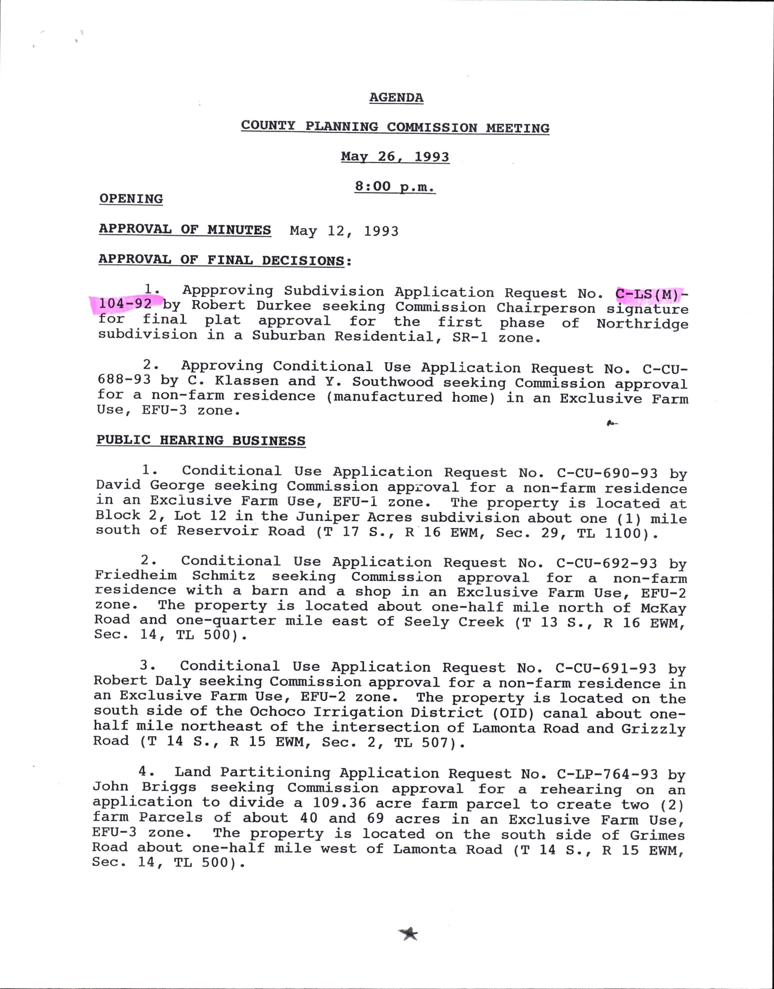
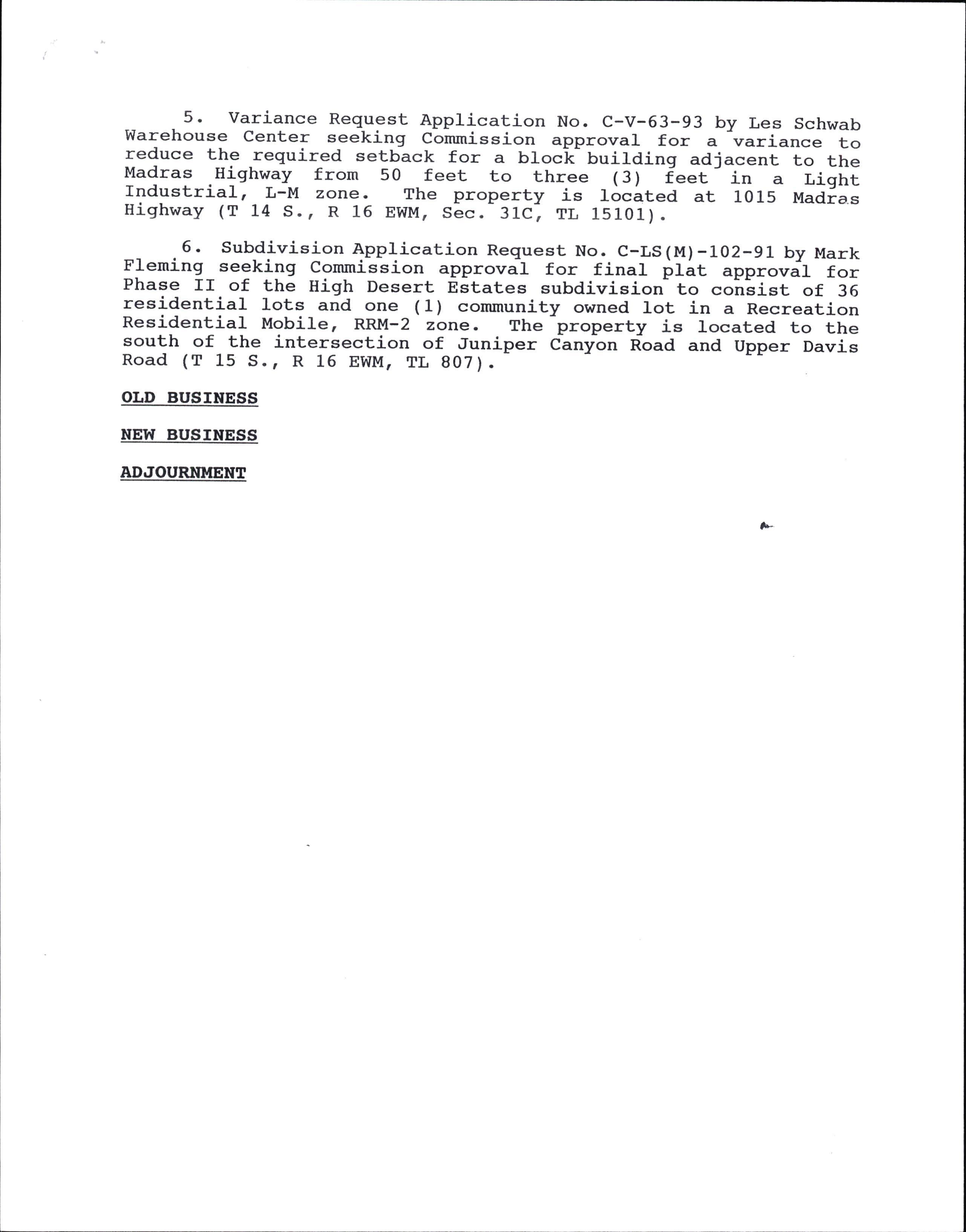
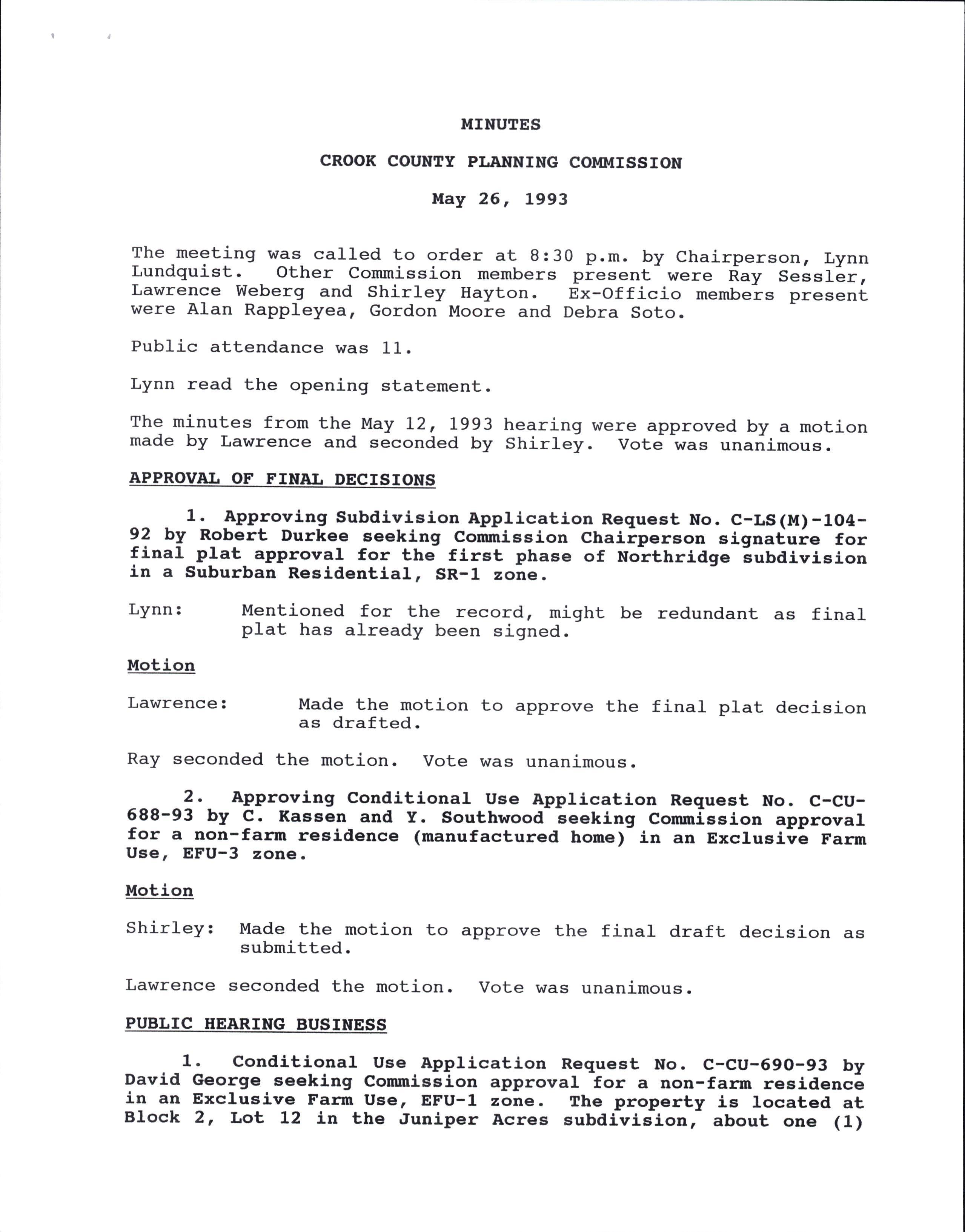
You may be unaware that the developer presented his proposal to the Commission in the form of proposed access, lot sizes, irrigation water use, domestic l^rater system and sewage disposal systen. Proposed and intended lot size for the entire 115+ acre area was presented by the developer throughout the public hearings. This proposal was inLEially begun as a Tentative Plan as shown on the proposal plat and Lhen changed to an Outline Plan proposal. With the proposal having been presented in this manner, we do not believe that the developer intended to have only the concept approved for a development of some sort in this area. Had the Commission given broad conceptual approval without consideration of the development plan, as presented, in relation to meeting the Comprehenslve Plan and Land Use Ordinances and then addressed the constraints and/or conditions for developrnent during the Tentative Plan stages, the developer would be here, before this courE, contending that his proposed development had been approved, as presented, by the Cornrnission during the Outline Plan stage.
The public record shows that we have never been opposed to this development simply because it is a development. We have, on the other hand, been opposed to it from the beginning based on facts and lssues pertinent to the developmenE proposal that conflicts wlth the Comprehensive Plan and Land Use Ordinances. While we don't entirely agree with the County Planning Commission's approval decision, we do know that many considerations and extensive deliberation went into that decislon process. The Planning Commission considered many difficult and critical facEs and issues over the course of three public hearings, personally visited the area on a public field trip and deliberated extensively in arriving at the present approval scenario. The decision was neither for the proponents or the opponents but rather a compromise allowing the development with conditions to bring it in line with the objectives and policies of the Comprehensive Plan and Land Use Ordinances. Although we would rather have not had any development in this area, we accepted the Planning Commission's decision simply because lt does bring the development much closer to being in line with the Comprehensive Plan and Land Use Ordinances which was all we could reasonably expect.
A portion of those most important and crltical facts and issues contained in the public record and pertlnent to lot slze were:
1. This proposal noL being in a Comprehensive Plan Development Priority Area, that is, served by public serlrage disposal and domestic water utilities.
Excessive underground water withdrawals.
Individual sewage disposal systems' effects on area resources
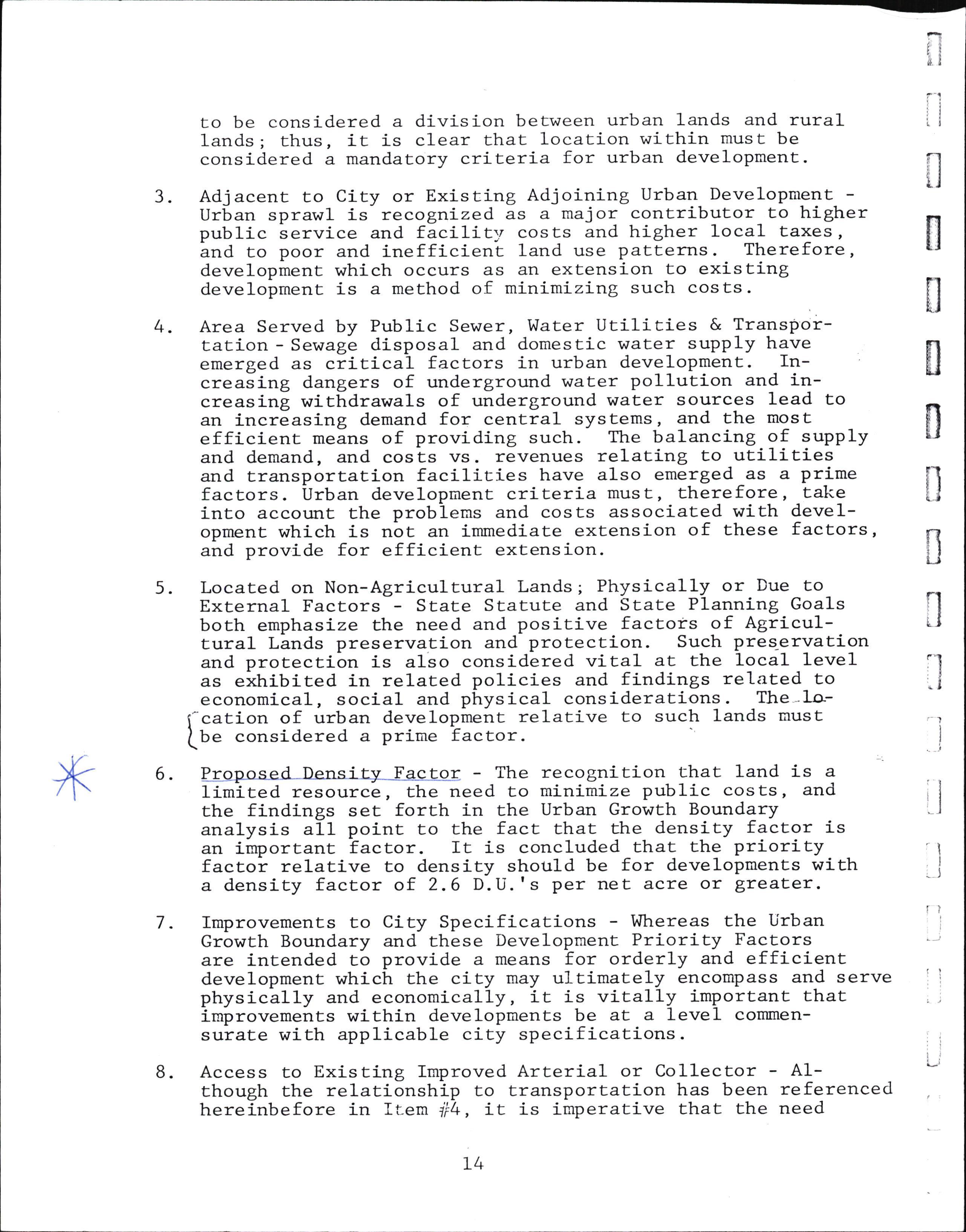
As you are aware, the Comprehensive Plan Urban Growth Policies (pg. 13) emphasize that the priority for development should be in areas served by public sewage disposal and domestic water utilities based on increasing dangers of underground water pollution and increasing withdrawals of underground water sources. The Comprehensive Plan's guidelines to help curtail potential water problems in new developments (pg. 45) also state that "ground water supply (and its carrying capaeity) shal1 be used as a maJor criteria for evaluation of any growth policies in Crook County". As we all know, the magnitude and effects of nonpublic sewage disposal and water utilities is directly proportionate to the density of residences included. The density proposed by the developer for this area would have included a tremendous annual withdrawal of approximaEely 44,000,000 gallons of underground domestic water and totaled approximately 200 individual septic systems. IE is not difficult Lo imagine the excessive quantities of sewage effluent that would be deposlted in the surrounding subsurface environment. Based on sheer numbers of systems, \re submit that the developer's proposal noE only exceeded the areats carrying capaeity, but should only be considered ln a public sewage disposal scenario.
The Comprehensive Plan Rural-Urban relatLonshlp relating to lot size and residence densities was of major issue before the Commission along \^rith all other directly related issues. We must remind everyone involved that the key word in discussing a community's overall densities is overall. To arrive at those overall densities *".ry -8.0 residences per acre ii-theu-rban city are averaged with a much lower number of 0.2 residences per acre in fringe areas. This development is not proposed in an urban setting but at Ehe outermost limits of the Urban GrowEh Boundary. I.Ie point out that the Comprehensive Plan Urban Growth Boundary pollcy is to assure that buffers occur between urban development and agricultural land practices by a decrease in housing densities as farm lands are approached. During Commissl-on hearlngs, Ehe developer agreed with that policy and the decision factor became lot size, at the outermost areas of the UGB, that would be compatible with surrounding land uses and resource carrying capacities both Conprehensive Plan policies. l,le emphasize that the developer's proposal to the Commission of maximum density of minimum legal lot sizes in this area undoubtedly violaEed both C"*prehensive PIan policies of buffer densities approaching the UGB and compatibility with surrounding land uses. The Commission's approval decision is by far more appropriate and conslderate of the Comprehensive Plan and Land Use Ordinances in an outlying area at the UGB and not served by public vrater and sewage disposal utilities. The Cornrnission approved buffer density is even more appropriate when considering other Comprehensive Plan ldentified special and unique surrounding land uses such as Hudspeth Reservoir (waterfowl nesting habitat) and Barnes Buttes Natural ScenLc Area.
The public record also conEalns detailed discussion of our differing views of meeEing the requirements and intent of the Land Use Ordinances as relating to lot size. The Land Use Ordinances simply set absolute minimum standards as just that "bottom line minimum standards not to be gone beyond". The developer viewed those minimum requirements as the standard requirements to be used with little consideration of the Comprehensive Plan policies, area resource carrying capacities or surrounding land uses.
IE is not the County's responstbility or obligation to ensure the profic margin of developers no matter where or how they choose to develop. If this propertsy cannot be developed responsibly in respect Eo the objectives and policies of the Comprehensive PIan and Land Use Ordinances and with the developer's necessary profit margin , at this time, then the developer has taken the chance of not recognizing and considering requirements earlier. We point out that the developer's proposal has never, during the Commission hearings, complled with the lntent, objective and policies of the Cornprehensive Plan and Land Use Ordinances. The developnent scenario approved by the Planning Commission, at the end of publlc hearings, is by far the closest to meeting the intent, objectives and policies of the Comprehensive Plan and Land Use Ordinances since the appllcation was orlginally submitted.
The public record contains much greaEer detailed discussion of these and other important facts and issues pertinent to the Planning Commission's approval decision for this development proposal as a whole.
orz"--z l/L l/d iz);-,
James I. McMil1in, et al.
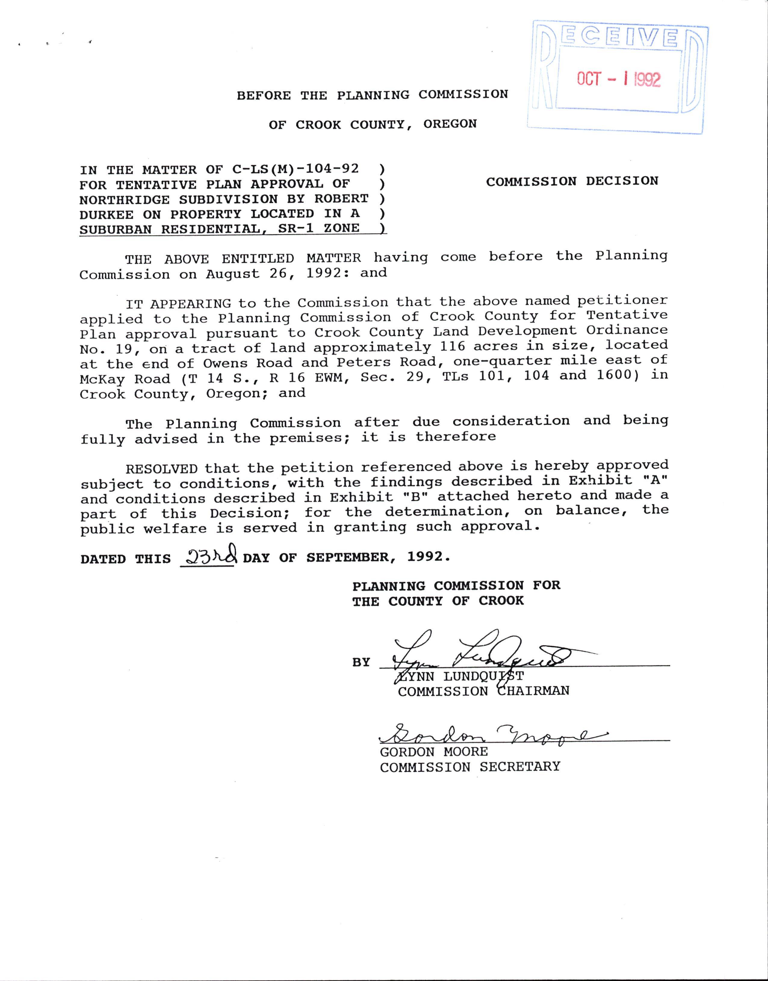
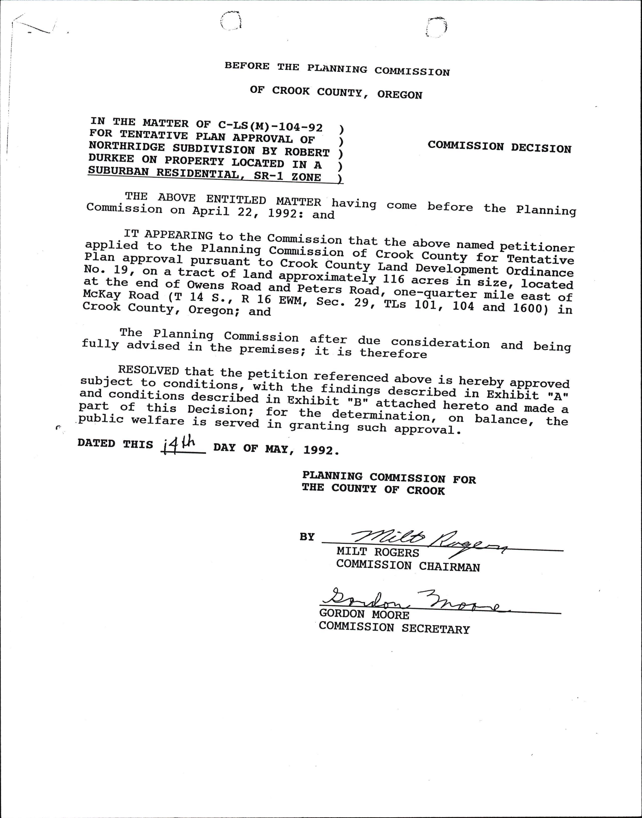
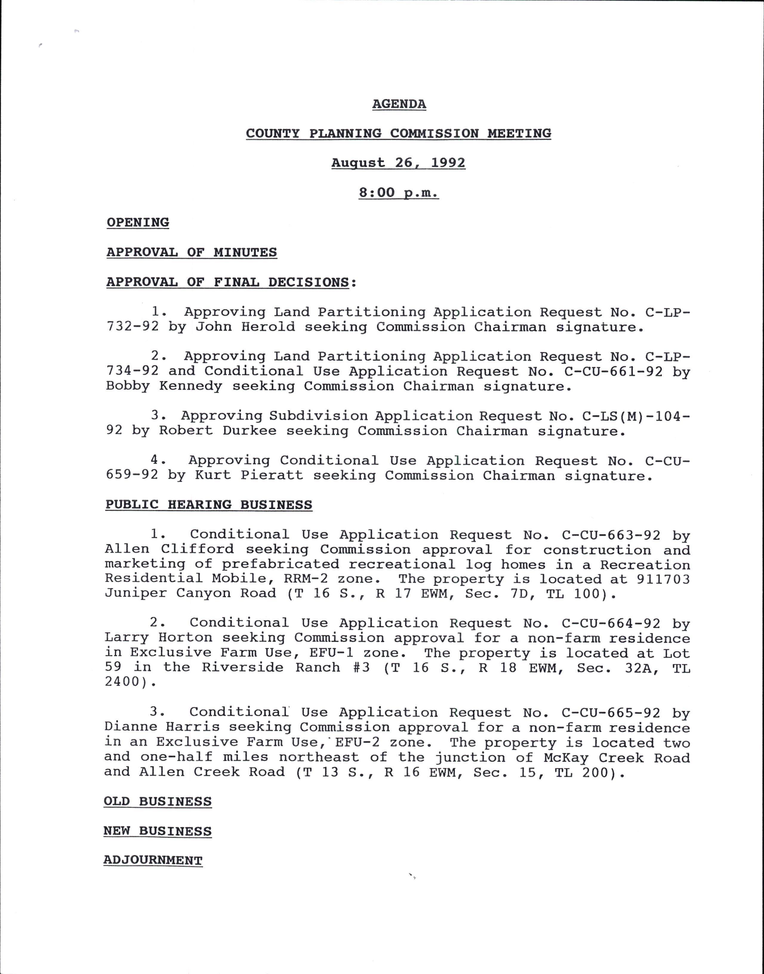
BEFORE THE PLANNING COMMISSION
oF cRooK couNTY, OREGON
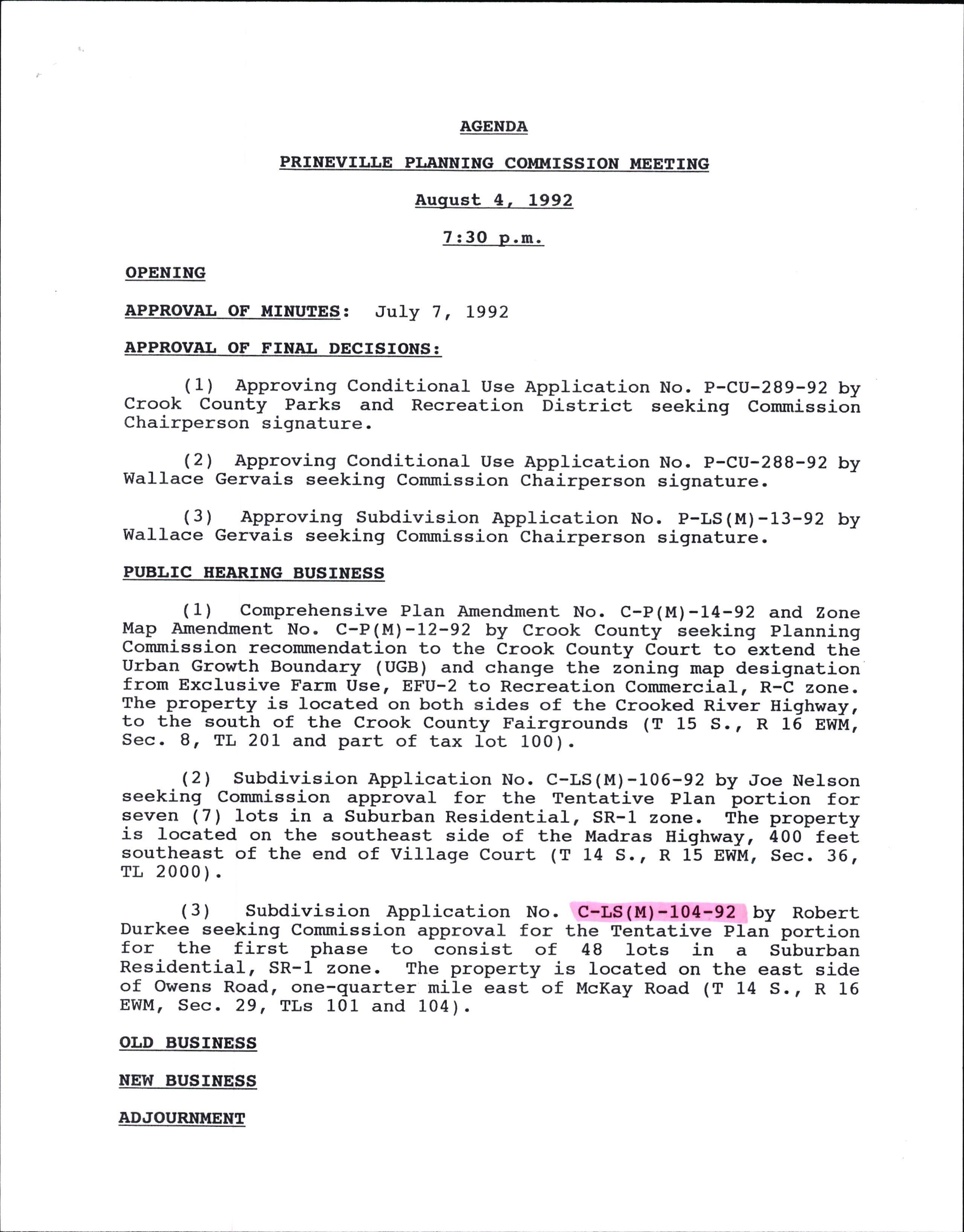
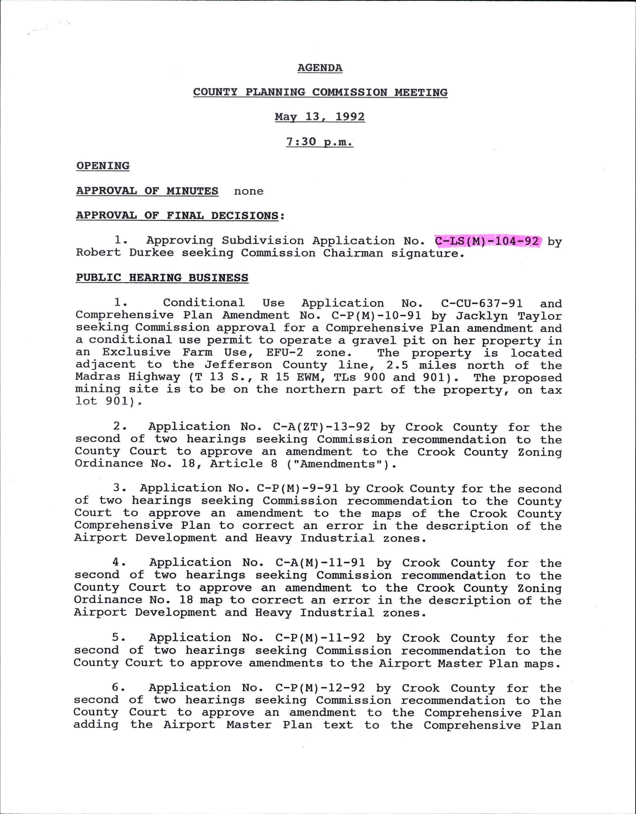
rN THE MATTER OF C-LS(M)-104-92 ) FOR TENTATTVE Pr.AN APPROVAL OF )
NORTHRTDGE SUBDMSION BY ROBERT )
DURr(EE ON PROPERTY LOCATED rN A )
SUBURBAN RESTDENTTAL, SR-1 ZONE )
ocT - I t992
COMMISSTON DECISION
THE ABOVE ENTITLED MATTER having Commission on August 26, L992: and come before the Planning
IT APPEARING to the Commission that the above named petitioner applied to the Planning Commission of Crook County for Tentative pian approval pursuant 1o Crook County Land Development Ordinance No. L9r-on a tr-act of land approximately 116 acres in size, located at the end of Owens Road and-peters Road, one-quarter mile east of McKay Road (T 14 S., R 16 EWIU, Sec. 29, TLs 101, 104 and 1600) in Crook County, Oregon; and
The planning Commission after due consideration and being fu1ly advised in the premises; it is therefore
RESOLVED that the petition referenced above is hereby approved subject to conditions, with the findings described in Exhibit rtA'r and conditions described in Exhibit r'Brr attached hereto and made a part of this Decision; for the determinationr or balance, the public welfare is served in granting such approval
DATED rErs d DAY oF sEPTEI{BER, Lg92 -
PI,ANNING COMMISSION FOR TEE COT'NTI OF CROOK LUNDQU T COMI,IISSION HAIRMAN
GORDON MOORE COMMISSION SECRETARY BY -
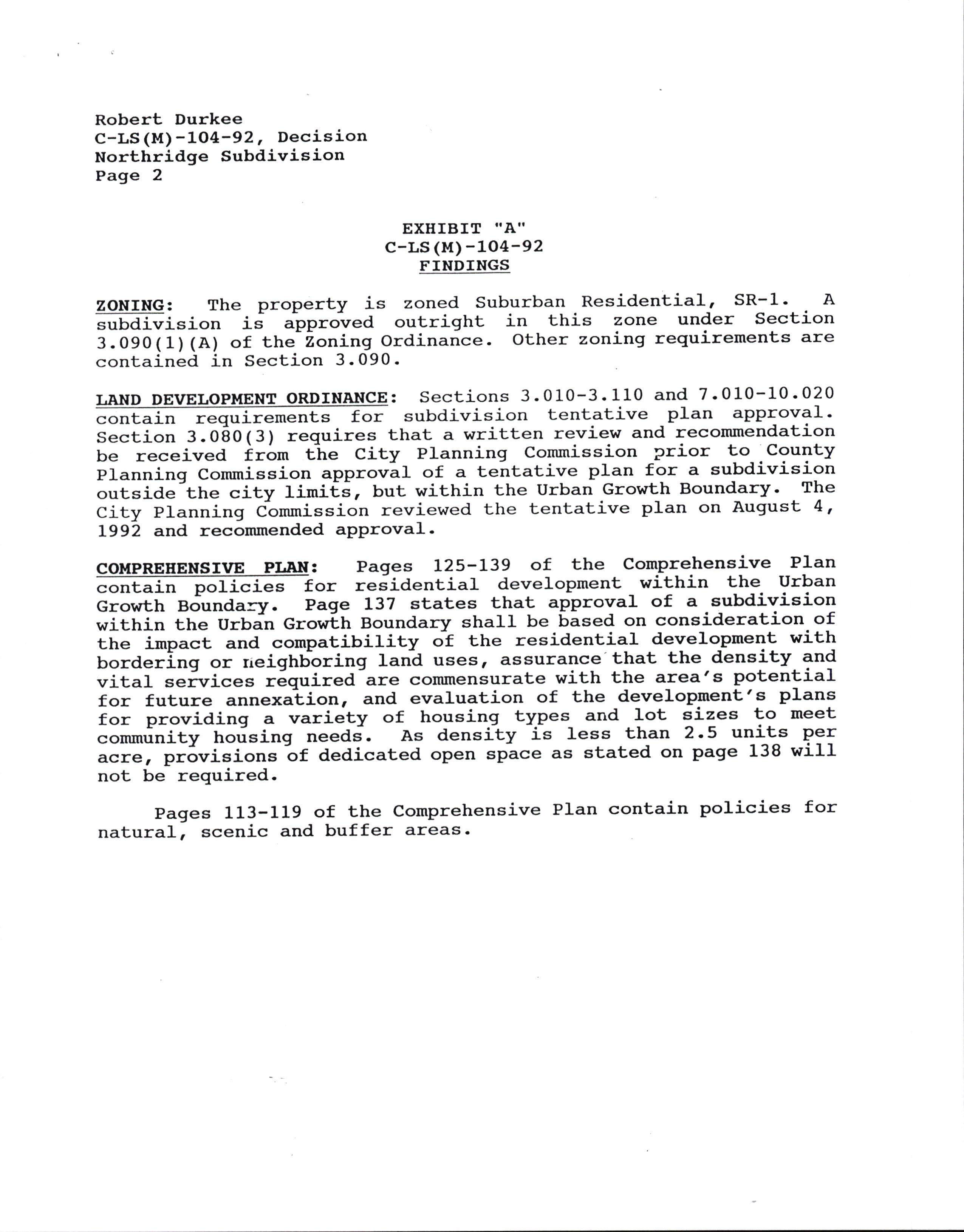
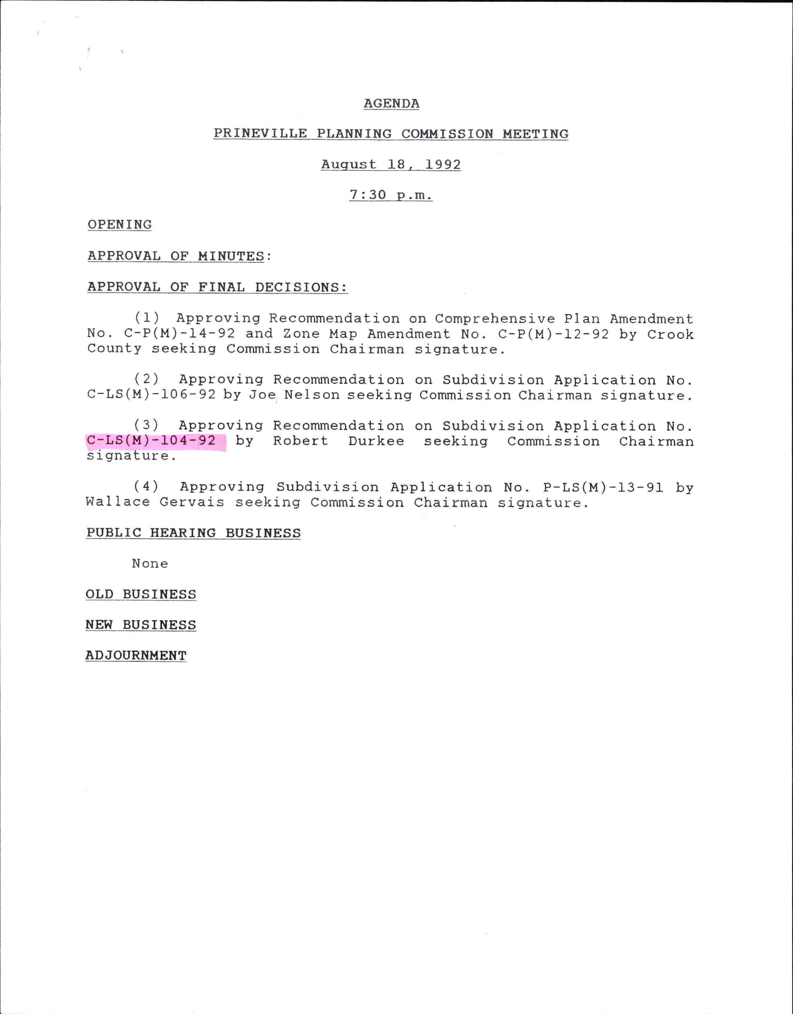
Robert Durkee C-LS(M)-104-92, Decision Northridge Subdivision
EXEIBIT "A'I
c-Ls (M) -1O4-92 FTNDTNGS
ZONING: The property is zoned suburban Residential, sR-I. A =obdi.ri"ion i; aipproiea outright in this zone under Section 3.090(1)(A) of the ,oning Ordinance. Other zoning reguirements are contained in Section 3.090-
LANp DEvELOpMENT ORDTNANCE: Sections 3.010-3.110 and 7-010-10.020 . subdivision tentative plan approval' Section 3.080(3) requires that a written review and recommendation be received i.6rn the City Planning Commission prior to County planning Commission approrit of a tentative plan for a subdivision outside the city limi€s, but within the Urban Growth Boundary- The City planning Ctrnmission reviewed the tentative plan on AugusL 4, I-992 and recommended aPProval-
CoMPREEENSM PLaN: Pages L25-L39 of the compre)rensive Plan @orresidentia1deve1opment-withintheUrban Growth aolundary. Page L37 states that approval of a subdivision within the Urbin Crowlh Boundary shall be bised on consideration of the impact and compatibility ok the residential develo_pment with bordering or rreighbbring land usesr assurance.that the density and vital t"irri""= r6quired are commensurate with the area's potenliat for future "rrrr"x"tiot, and evaluation of the development's plans for providing a variety of housing types and lot sizes to meet -ommrinity hotising needs-. As density is less than 2.5 units P9f acre, pr6visions -ot a"ai"ated open "pace as stated on page 138 will not be required.
Page 2 natural,
Pages 113-119 of the Comprehensive Plan contain policies for scenic and buffer areas-
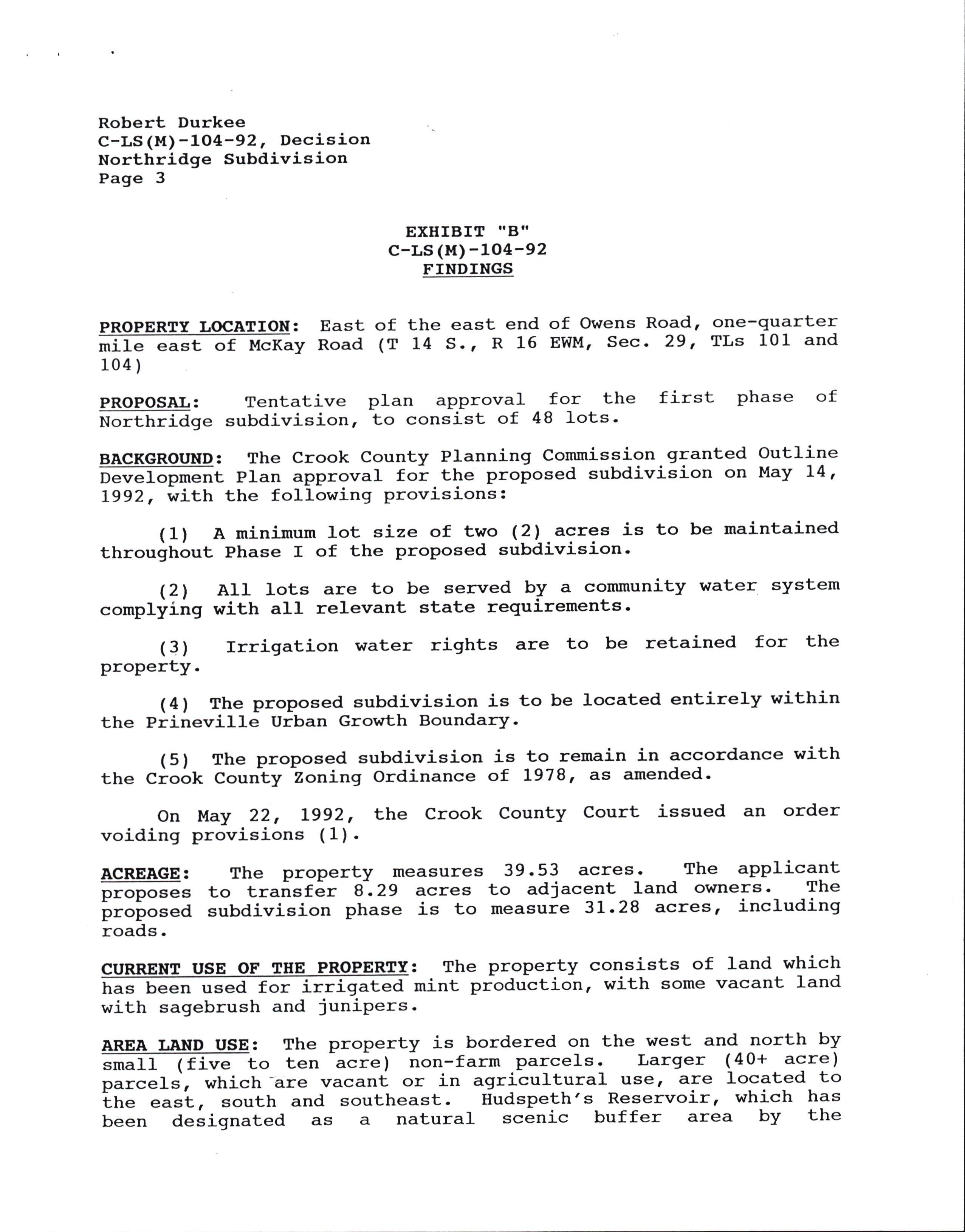
Robert Durkee C-LS (M)-104-92, Decision
Northridge Subdivision
Page 3
EXHIBIT TIBII
c-Ls (M) -104-92
FINDTNGS
PROPERTY LOCATION : EaSt of (T
mile east of McKay Road 104 )
the east end of Owens Road, one-quarter L4 S., R 16 EWM, Sec- 29, TLs 101 and
PROPOSAL: Tentative plan approval for the first phase of ttorttrriage subdivision, to consist of 48 lots'
BACKGROTND: The Crook County Planning Commission granted Outline D"""Iop*""t plan approval foi tt'e proposed subdivision on l'lay L4, L992, with the following provisions:
(1) A minimum lot size of two (2).acres is to be maintained throughout Phase I of the proposed subdivision'
(21 AIl lots are to be served by a community water system complliii:g with atl relevant state requirements '
(3) rrrigation water rights are to be retained for the property.
(4) The proposed subdivision is to be located entirely within the Prineville Urban Growth Boundary-
(5) The proposed subdivision is to remain in accordance with the Crook Counly Zoning Ordinance of L978r ds amended.
on l{ay 22, Lgg2, the crook county court issued an order voiding provisions ( 1 ) .
ACREAGE: proposes proposed roads.
The propertY measures to transfer 8.29 acres subdivision phase is to
USE OF TEE has been used for irrigated with sagebrush and juniPers-
39.53 acres. The aPPlicant to adjacent land owners- The measuie 3L.28 acres, including
: The property consists of land which mint prtduction, with some vacant land
AREA LAND USE: The property is bordered on the west and north by =t*f f 1tirt" t" ten -acie ) non-f arm parcels. Larger ( 40+ acre ) parcels, which -are vacant or in agrjcultural use, are located to tt" east, south and southeast. Hudspeth's Reservoir, which h3' been designated as a natural scenic buffer area by the
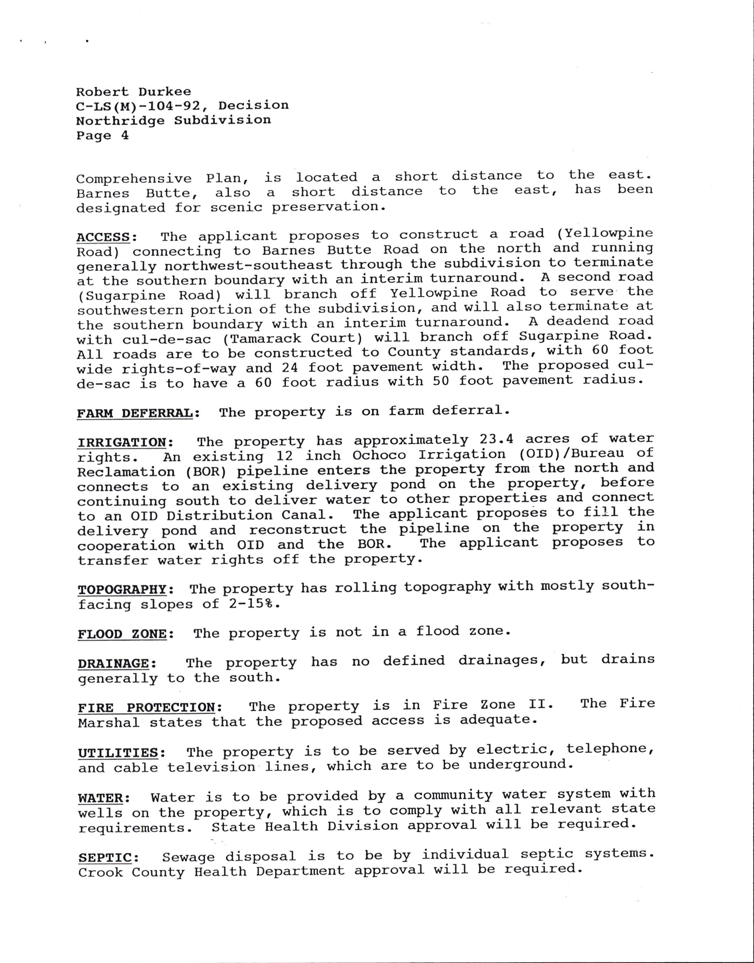
Robert Durkee C-LS(M)-104-92, Decision Northridge Subdivision
Page 4
Comprehensive Plan, is located a short Barnes Butte, also a short distance designated for scenic preservation-
distance to to the east, the east. has been
ACCESS: The applicant proposes to construct a road (Yellowpine no"a I "onnectirij to Bar-nes- Butte Road on the north and running generally northviest-southeast through -the subdivision to terminate it tt" southern boundary with an interim turnaround. A second road (Sugarpine Road) will branch off Yellowpine.-Road to serve the =o,rf,hwE=tern portion of the subdivision, and wiII also terminate at the southern -boundary with an interim turnaround. A deadend road with cul-de-sac (Tamirack Court) will branch off Sugarpine--Road. AII roads are to be constructed to County standards, with 60 foot wide rights-of-way and 24 foot pavement width. The proposed-cuIde-sac is to have a 60 foot radius with 50 foot pavement radius-
FARM DEFERRAL: The property is on farm deferral'
IRRIGATION: The property has approximately ?3.4 acres of water rightr. Ap exist^inf 12 inch OEhoco Irrigation (OTD)/Bureau of ne6lamation (BOR) pifeline enters the property from the north and connects to an "xlJting delivery pond on the property, before continuing south to deliver water to other properties and connect to an OID Distribution Canal. The applicant proposi:s to fill the delivery pond and reconstruct the pipeline on the property in "oop"t.Liot with OID and the BOR. The applicant proPoses to transfer water rights off the property.
TOPOGRAPBI: The property has rolling topography with mostly southfacing slopes of 2-L52.
FLOOD ZONE: The property is not in a flood zone'
DRAINAGE: The property has no defined drainages, but drains generally to the south.
FIRE PROIECTION: The property is in Fire Zone II' The Fire f-l"rstraf states that the proposed access is adequate.
UTILIrIES: The property is to be served by electric, telephone, ""d ""ble televiJion tines, which are to be underground-
WATER: Water is to be provided by a community water system with wells on the property, which is to comply with all relevant state requirements. Slate-iealth Diwision approval will be required.
SEPTIC: Sewage disposal is to be by individual septic systems' croot< County H1a1th bepartment approval will be required.
Robert Durkee C-LS(M)-104-92, Staff RePort Northridge Subdivision
Page 5
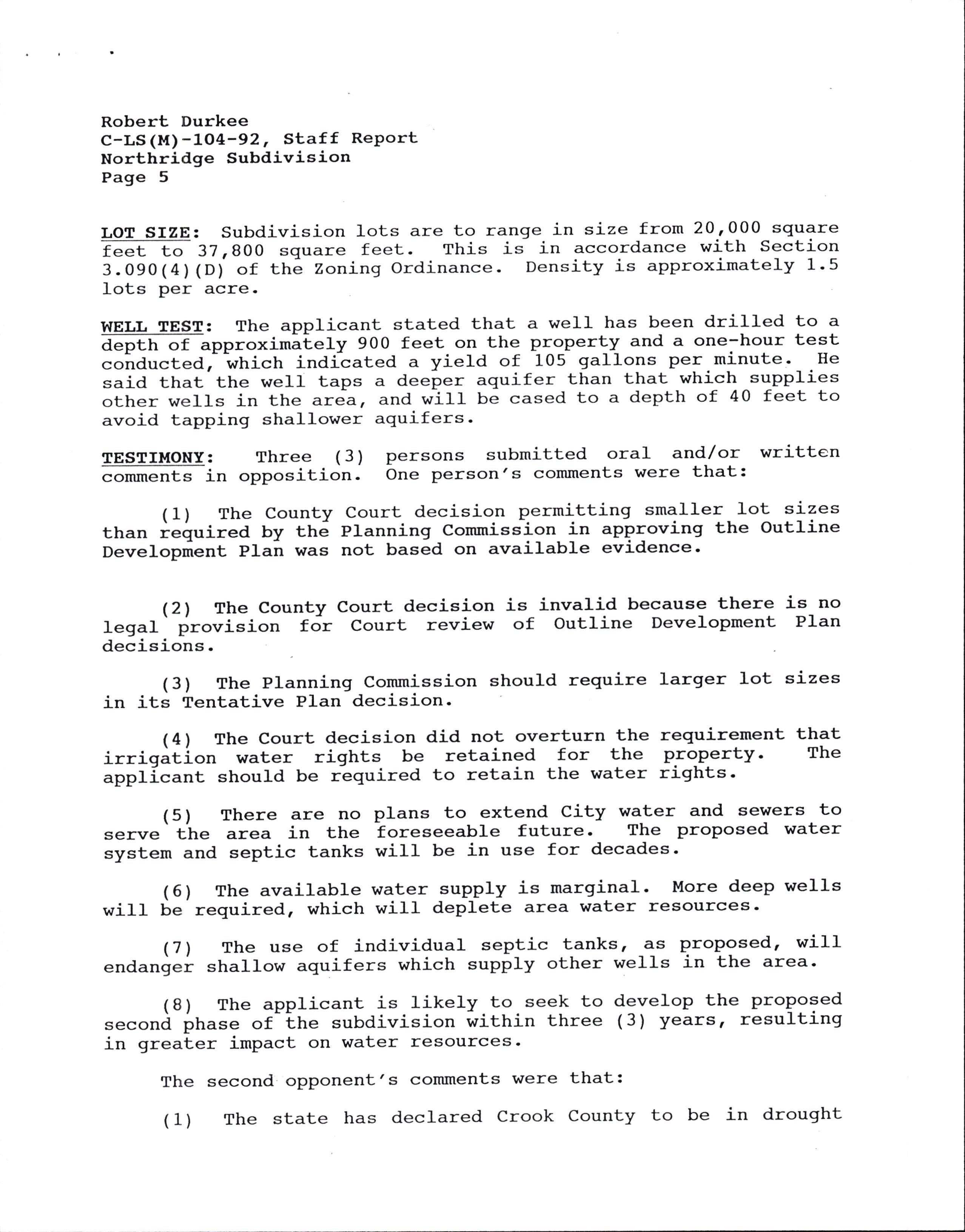
LoT SIZE: Subdivision feet to 37,800 square 3.090(4) (D) of the Zon lots per acre.
lots are to range in size from 20r000 square feet. This is in accordance with Section ing ordinance. Density is approximately 1.5
WELL TEST: The applicant stated that a well has been drilled to a d"pth "f "pproximitely 900 feet on the property and a one-hour test coirducted,--o,hictr indi?ated a yield of 105 gallons per minute. He said that the well taps a deeper aquifer than that which supplies other wells in the are., and will be cased to a depth of 40 feet to avoid tapping shallower aquifers.
TESTII.{ONY: Three ( 3 ) persons submitted oral and/or written ""*.""t= in opposition. One person's comments were that:
(1) The County Court decision permitting smaller lot sizes than iequired by th6 planning Commission in approving the Outline Oevelopnlent plan was not based on available evidence.
(21 The County Court decision is invalid because there is no legal' provision for Court review of Outline Development Plan decisions.
(3) The planning Commission should require larger lot sizes in its Tentative Plan decision
(4) The Court decision did not overturn the requirement that irrigition water rights be retained for the property. The appllcant should be rLquired to retain the water rights.
(5) There are no plans to extend City water and sewers to serve'the area in the foreseeable future. The proposed water system and septic tanks will be in use for decades.
(6) The available water supply is marginal. More deep we1ls will be required, which will deplete area water resources.
(7) The use of individual septic tanksr ES proposed, will endanger shallow aquifers which supply other wells in the area'
(B) The applicant is likely to.seek to develop the proposed r""orrd phase of-the subdivision within three (3) years, resulting in greater impact on water resources.
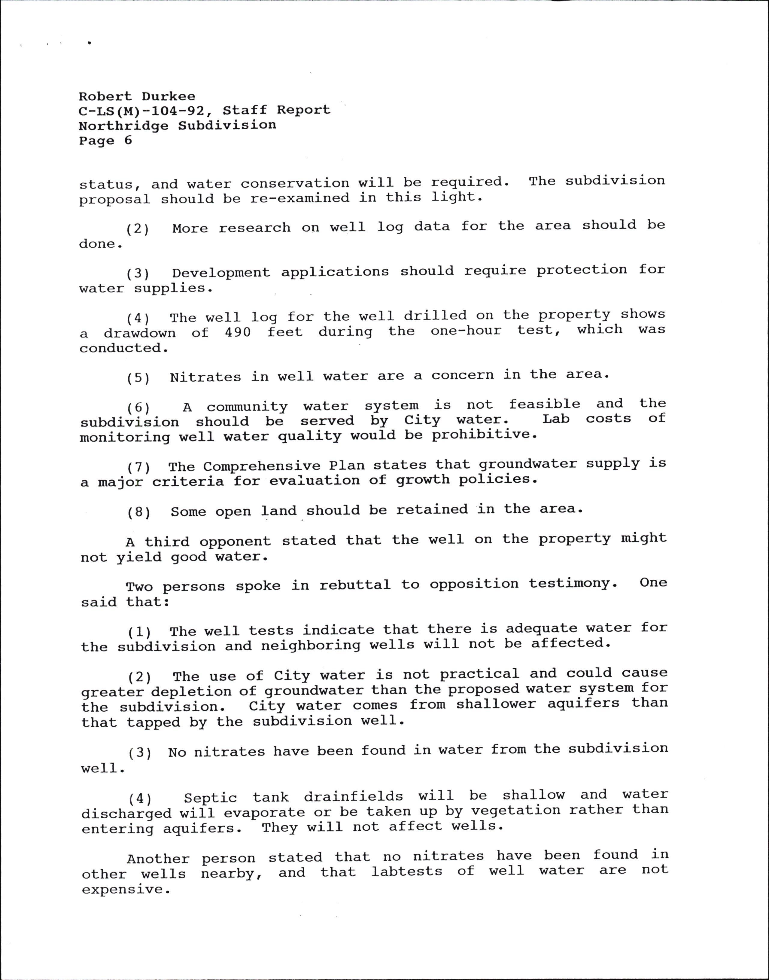
The second opponent's comments were that:
(1) The state has declared crook county to be in drought
Robert Durkee C-LS(M)-104-92, Staff RePort Northridge Subdivision
Page 6
status, and water conservation wiII be required. The subdivision proposal should be re-examined in this light.
(21 More research on well log data for the area should be done.
(3) Development applications should require protection for water supplies
(4) The weII log for the well drilled on the property shows a drawdown of 4gO feet during the one-hour test, which was conducted.
(5) Nitrates in well water are a concern in the area.
(6) A community water system is not feasible and the subdivision should be served by City water. Lab costs of monitoring well water quality would be prohibitive.
(7) The Comprehensive PIan states that grogndwater supply is a major criteria tor evaiuation of growth policies'
(8) Some open land.should be retained in the area'
A third opponent stated that the well on the property might not yield good water.
Two persons spoke in rebuttal to opposition testimony. One said that:
(1) The well tests indicate that there is adequate water for the subdivision and neighboring wells will not be affected'
(21 The use of City water is not practical and could cause greater'depletion of groundwater than the prop_o_sed water system for €n" subdiv:ision. City water comes from shallower aquifers than that tapped by the subdivision well.
(3) No nitrates have been found in water from the subdivision wel1.
(4) Septic tank drainfields will be shallow and water discharged wifl evaporate or be taken up by v-egetation rather than entering aquifers. They witl not affect wells'
Another person stated that no nitrates have other wells nearby, and that labtests of well expensive.
been found in water are not
Robert Durkee C-LS(M)-104-92, Staff RePort Northridge Subdivision
Page 7
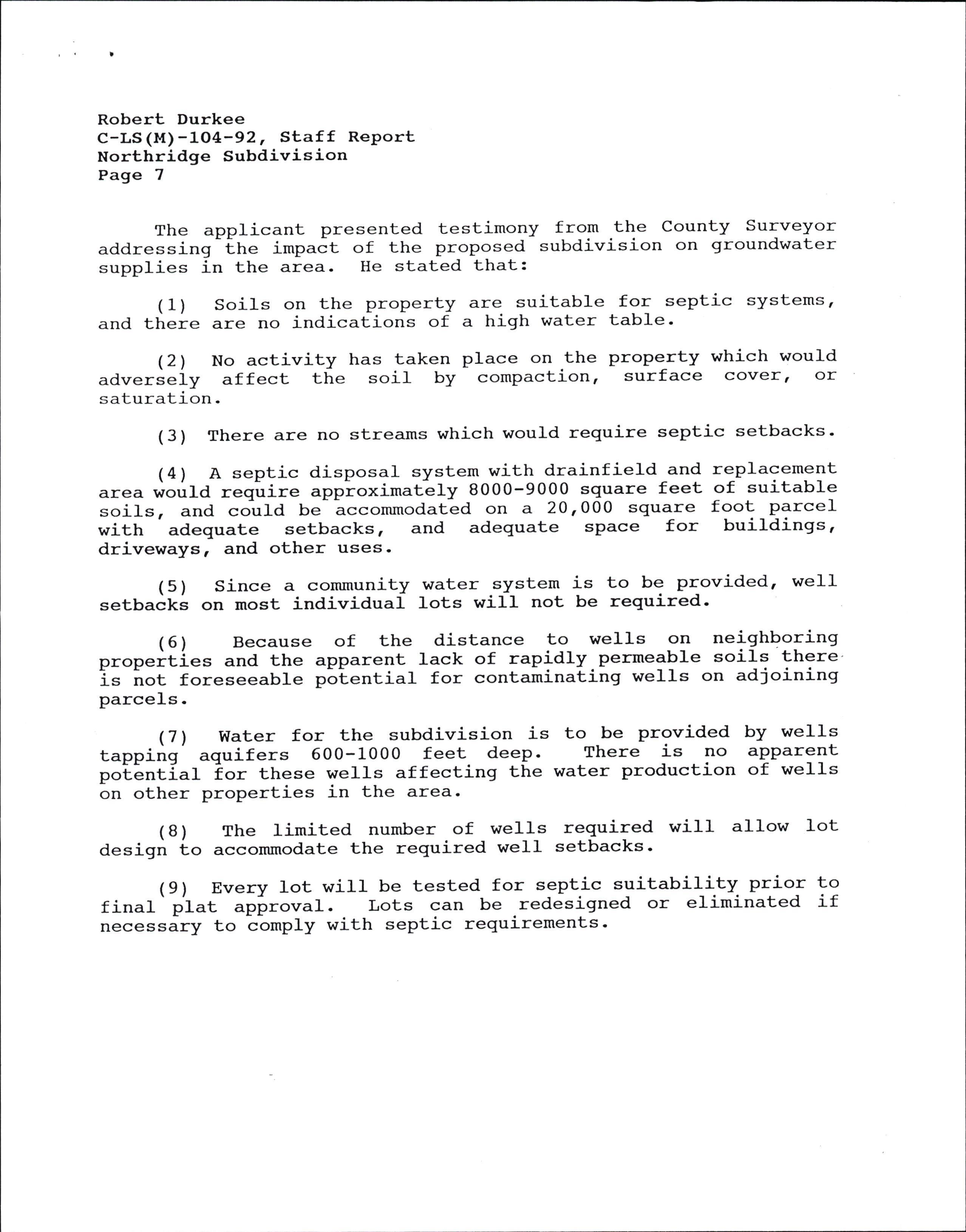
The applicant presented testimony from the County Surveyor addressirrg-itr" impact of the proposed subdivision on groundwater supplies in the area. He stated that:
(1) Soils on the property are suitable for septic systems, and there are no indications of a high water table'
(21 No activity has taken place on the property which would adverseiy affect the soit by compaction, surface cover, or saturation.
(3) There are no streams which would require septic setbacks.
(4) A septic disposal system with drainfield and replacement area would ..q-oir" approximatLly B0OO-9000 square feet of suitable soils, and coula be hccommodated on a 201000 square foot parcel with adequate setbacks, and adequate space for buildings, driveways, and other uses.
(5) Since a community water system is to be provided, weII setbacks on most individual lots will not be required.
(6) Because of the distance to wells on neighboring prop"ities and the apparent lack of rap!dly-permeable soils there i= irot foreseeable p6tential for contaminating wells on adjoining parcels.
(71 water for the subdivision is to be provided by wells tapping aquifers 600-1000 feet deep. There is no apparent po'tlntla1 tor these wells affecting the water production of welIs on other properties in the area-
(B) The limited number of wells required will allow Iot design to accommodate the required well setbacks'
( 9 ) Every lot will be tested f or septic suitabil_i_ty. priol !9 final' plat apiroval. Lots can be redesigned or eliminated if necessary to tomply with septic requirements.
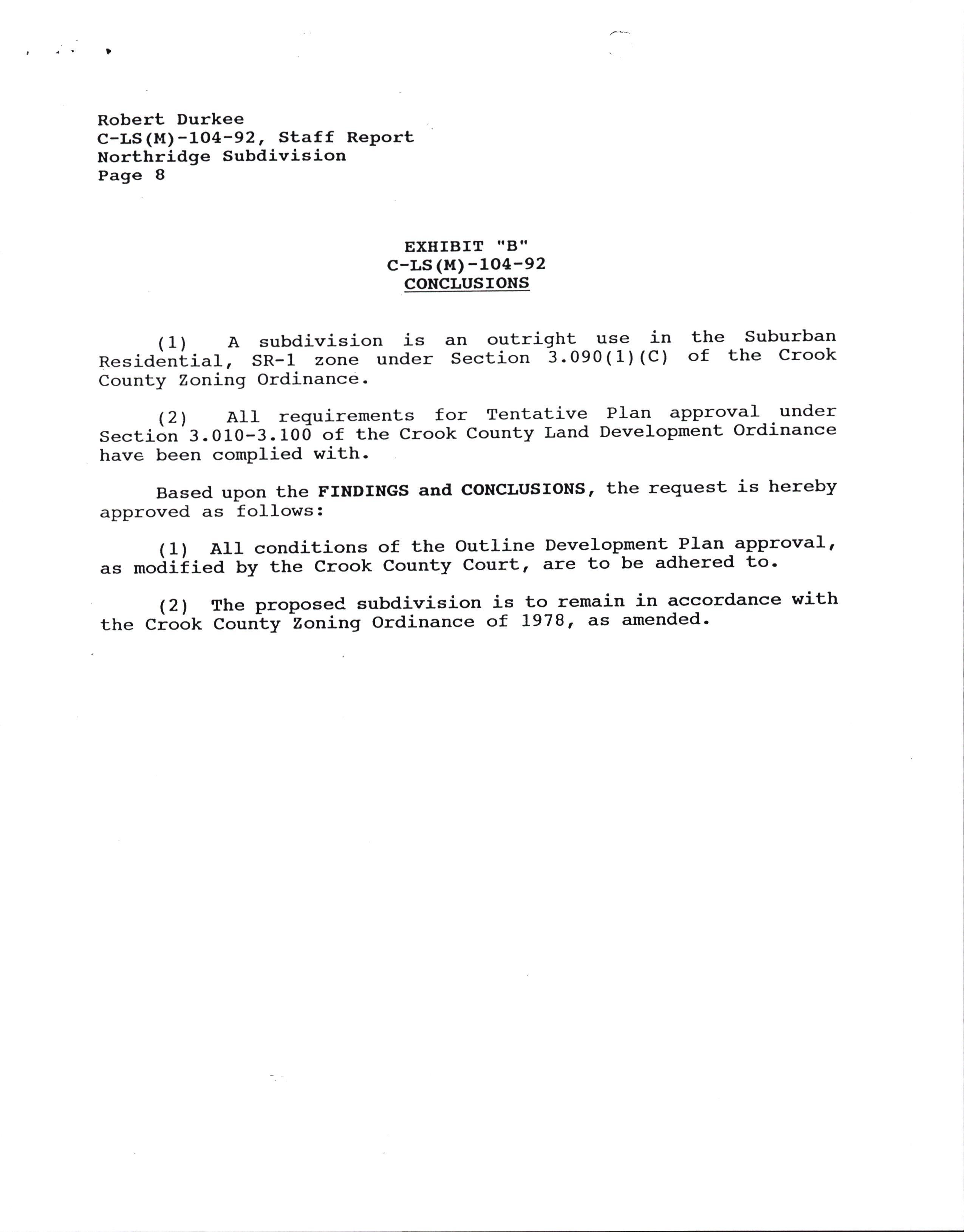
(1) A subdivision is Residential, SR-1 zone under County Zoning Ordinance-
an outright use in Section 3.090(1) (C) the Suburban of the Crook
(21 A1I requirements for Tentative Plan approval under Section 3.010-3.100 of the Crook County Land Development Ordinance have been complied with-
Based upon the FINDINGS and GoNCLUSIONS, the request is hereby approved as follows:
(1) AIl conditions of the Outline Development_PIan approval, ." *oaiiied by the Crook County Court, are to be adhered to'
(21 The proposed subdivision is to remain in accordance with the Crook Courity Zoning Ordinance of l97gr ds amended.
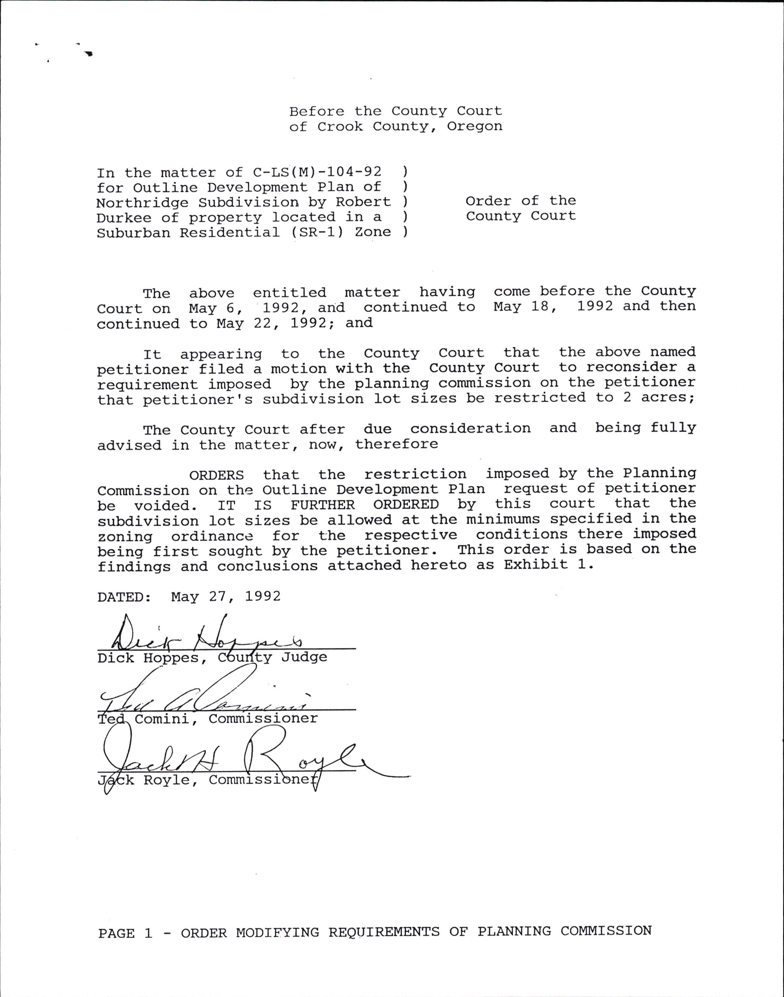
Before the County Court of Crook County, Oregon
In the matter of C-LS(M)-104-92 for outline Development Plan of Northridge Subdivision bY Robert Durkee of property located in a Suburban Residential (SR-L) Zone
Order of the County Court
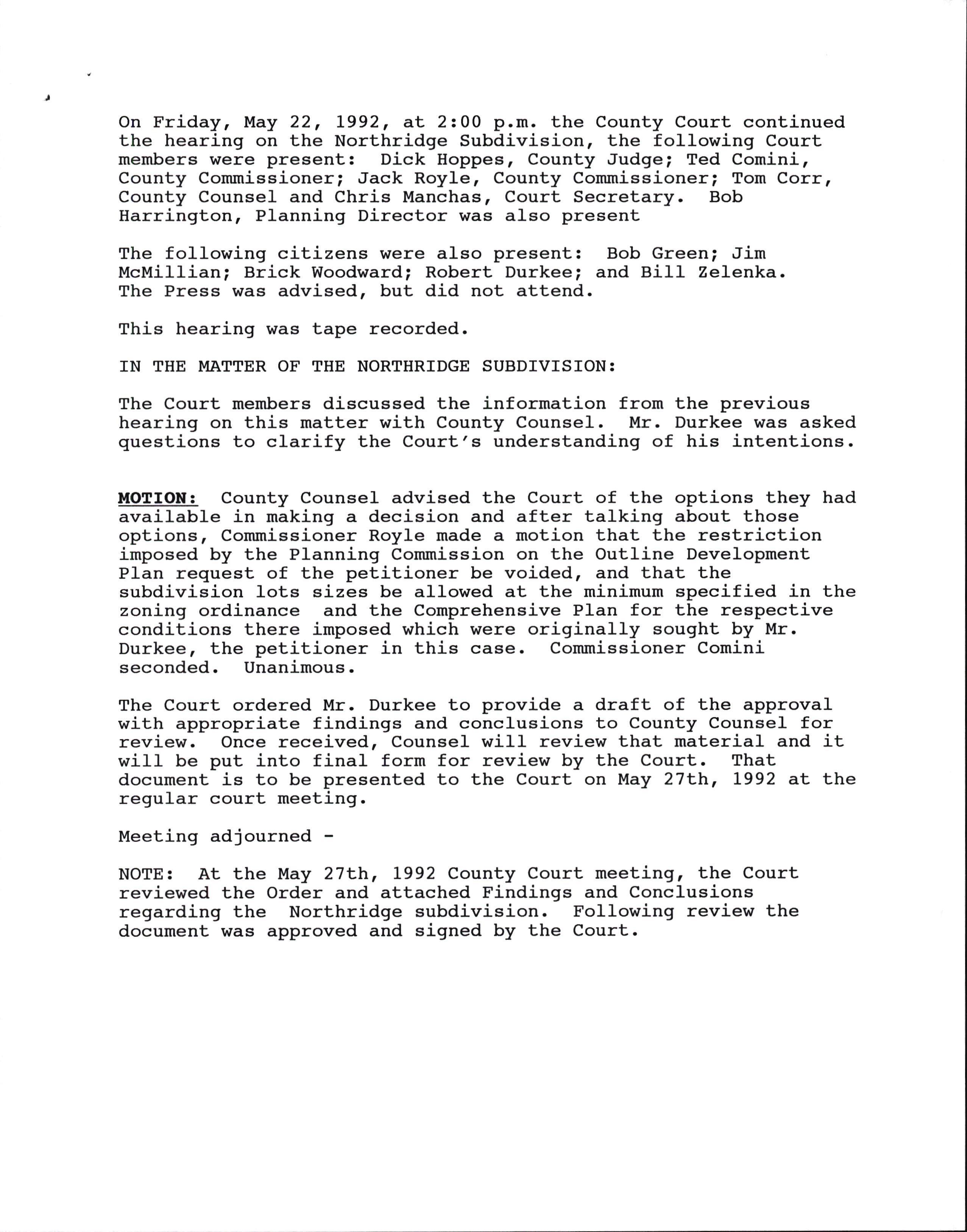
The above entitled matter having Court on May 6, 1992, and continued to continued to Nlay 22, L992; and
come before the County May 18, L992 and then
It appearing to the County Court that the above named petitioner iiled a motion with the County Court to reconsider a requirement imposed by the ptanning commission on the petitioner that petitionerrs subdivision lot sizes be restrj-cted. to 2 acres;
The County Court after due consideration and being fully advised in the matter, Ilow, therefore
oRDERS that the restriction imposed by the Planning Commission on the Outline Development PIan request of petitioner be voided. IT IS FURTHER ORDERED by this court that the subdivision lot sizes be allowed at the minimums specified in the zoning ordinance for the respective conditions there imposed being first sought by the petitioner. This order is based on the findings and conclusions attached hereto as Exhibit 1.
DATED: NIay 27 , L992
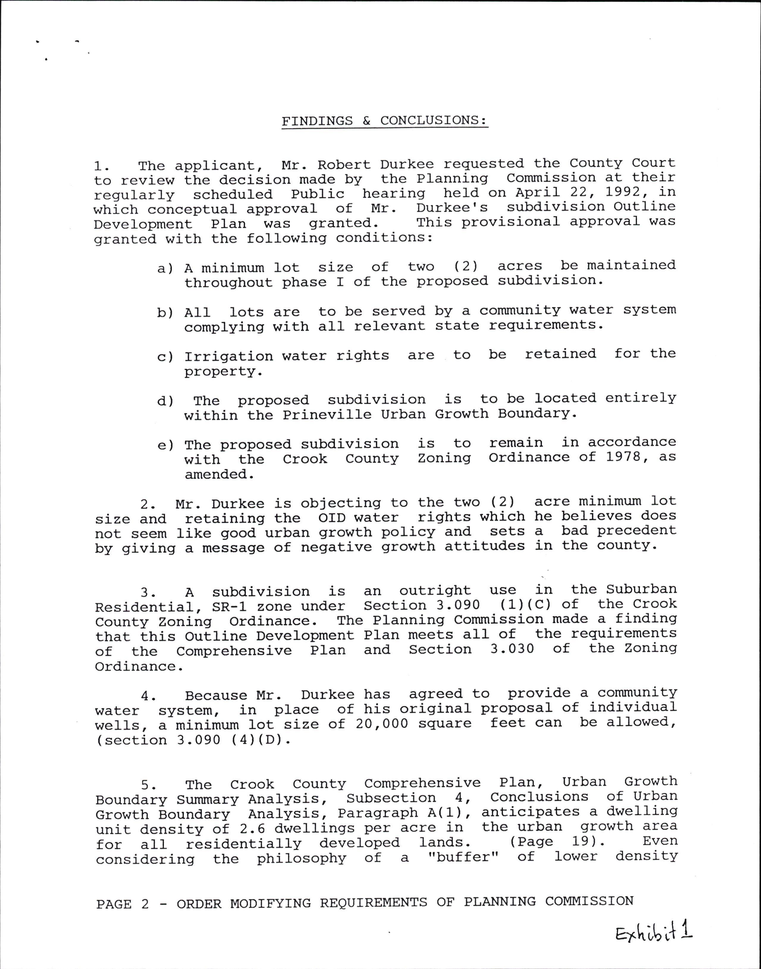
FINDINGS & CONCLUSIONS:
1. The applicant, Mr. Robert Durkee reguested the County Court to review ttre decision made by the Planning Commission at their regularly scheduled Public hearingr held on April 22, L992, in which conceptual approval of Mr. Durkee's subdivision outline Development PIan was granted. This provisional approval was granted with the following conditions:
a) A minj-mum lot size of two (2) acres be maintained throughout phase I of the proposed subdivision'
b) AII lots are to be served by a community water system complying with aII relevant state requirements'
c) Irrigation water rights property.
are to be retained for the
d) The proposed subdivision is to be located entirely within the Prineville Urban Growth Boundary.
e) The proposed subdivision is to remaj-n in accordance with the crook county Zoning ordinance of 1-978, dS amended.
2. Mr. Durkee is objecting to the two (2) acre minj-mum Lot size and. retaining the OID water rights which he believes does not seem like good urban growth policy and sets a bad precedent by giving a message of negative growth attitudes j-n the county.
3. A subdivision is an outright use j-n the Suburban Residential, SR-1 zone under Section 3.090 (1) (C) of the Crook County Zoning Ordinance. The Planning Commission made a finding that Lnis Outline Development PIan meets a1I of the requirements of the Comprehensive Plan and Section 3.030 of the Zoning Ordinance.
4. Because Mr. Durkee has agreed to provide a community water system, in place of his original proposal of individual we11s, a minimum }ot size of 20,000 square feet can be alIowed, (section 3.090 (4) (D).
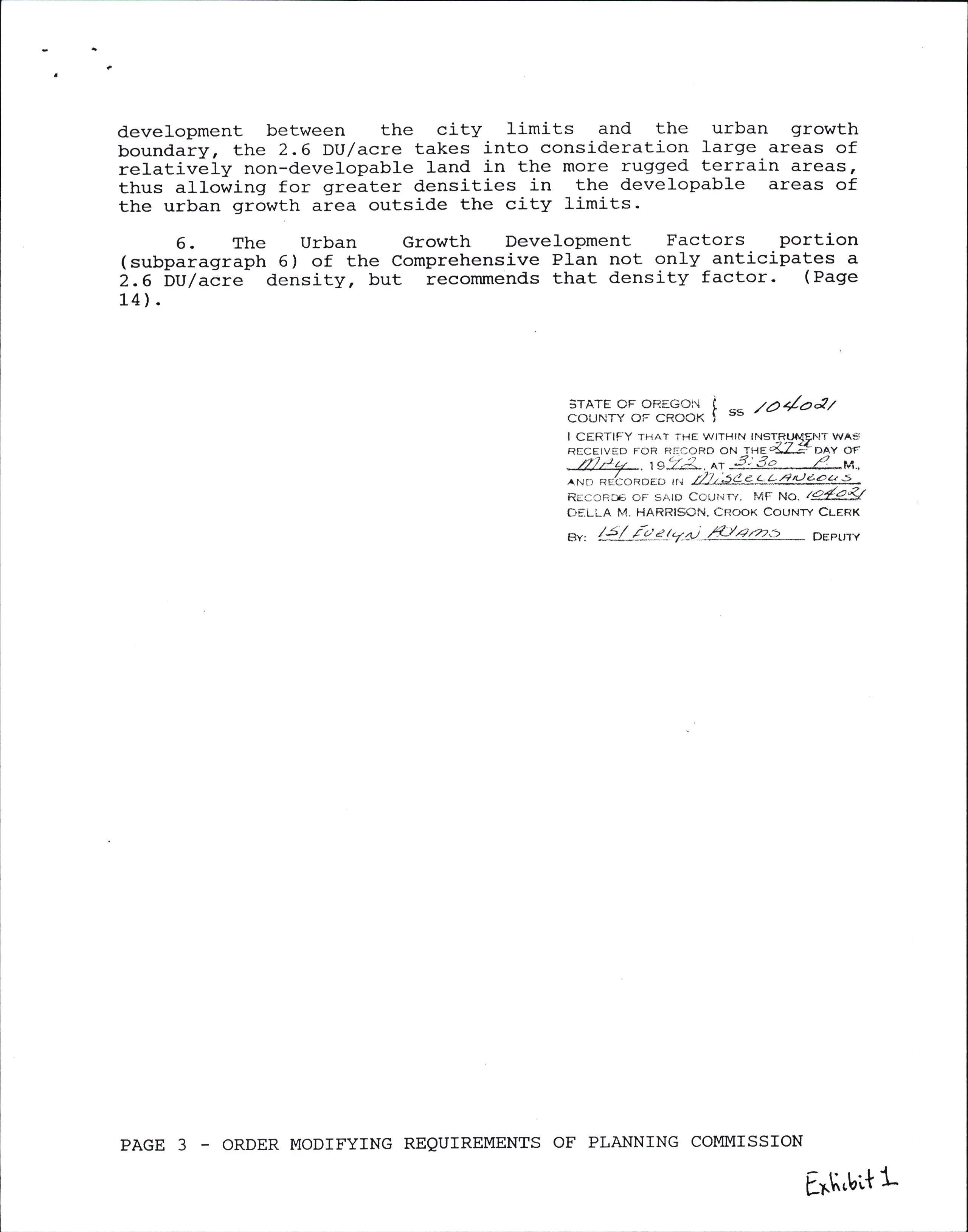
5. The Crook county comprehensj-ve Plan, urban Growth Boundary Summary Analysis, Subsection 4, Conclusions of Urban Growth Aoundary- Analysis, Paragraph A(1), anticS-pates a dwelling unit density oi 2.6 dwellings per acre in the urban growth area for all residentially developed lands. (Page 19). Even consi-dering the philosophy of a "buf fer" of lower densJ-ty
development between the city limits and the urban growth boundary, the 2.6 DU/acre takes into consj-deration large areas of relatively non-d"evelopable land in the more rugged terrain areas, thus allowing for greater densities in the developable areas of the urban growth area outside the city limits-
6. The Urban Growth DeVelopment Factors portion (subparaqraph 6) of the Comprehensive Plan not only antici-pates a 2.6 bU/acre densj-ty, but recommends that density factor. (Page 14).
COUNTY OF CROOK )
:rIL9191Esgl- t "'
tay'aat
I CERTIFY THAT THE WITHIN INSTRTruENT vvAs REcETvED FoR R!:coRD oN taz4Z? DAY oF ZJtru tg';r.:!-. o, 3:3q L,U., ^*o *16o*oeo uu ./Jrs9-gL(ru!932- REccR oF sArD Ceur.ir/. l,4F No. /e.r':a-q OELLA T'4. HARRISON, CNOOX COUI{W CLERK er, 4-/-/.-!-</zat -&cze.- DEPUTY
BEFORE TIIE PL}INNING COMMTSSTON oF CROOK COUNTY, oREGON
IN TEE }IATTER OF c-LS (M) -1O4-92 FOR TENIATIVE PI.AN APPROVAL OF NORTERIDGE SUBDTVTSTON BY ROBERT DURKEE ON PROPERTY TOCATED INA -1
COII{MISSION DECfSfON ) ) ) ) )
c""*il51.fl.o"*on11l'Y:or$;lT"ohavins come berore the plannins
rr APPEARTNG to the commission that the-above named petitioner applied to the_ pIa""i"g iirr,i""r"" lt*t.oot county-ior Tentative plan approval pursuant :Eo c_."-"t co;"ty h;a ,;;liiirlrrt ordinance
r u u y rlE"t1'"T T,l i r:"Hffi : ::, T.. "i ti: = :r"#"'d e ra t i on a nd b e i n s
RESOLVED that the petition referenced above is hereby approved subject to conditions-, -;iA tne-iinar;;. described in Exhibit ..A, and conditions aescrib"J r; n*irif,it':G:,v:ttached hereio and made a part of this^ o,ej:i_s^ron;- ttr the aetEnJn;d;;; .Jrr-=t"rance, the public welfare is served in granting such approval.
DAIED rurs i{{h DAy oF yay, tss2.
PLANNTNG COUMTSSTON r.OR TEE COUNTY OF CROOK BY MrI,T ROGERS coMMrSS rON CEATRMAN
GORDON MOORE COIUMTSSTON SECRETARY
NORTIIRIDGE SUBDIVISION
c-Ls(u)-104-92, DECTSToN
Page 2
EXEIBIT IIA"
c-Ls(M)-1O4-92
FINDINGS
(1) Subject property is located at the end of Owens Road and peters itoad, i.r"-{o"iter-mile east of McKay Road (T L4 S., R 16 Ewt{, Sec. 29, TLs 101-' 104 and 1600).
(21 Submission of an Outline Develo,pmentPlan for a suUairlilion pii*irify in a Suburban Residential, SR-l zone, which is proposed Lo be imllemented in two (21 phases: .A detailed plan has-beln submitted f-or the first phase, to consist of 45 lots.
(3) Tax Lot 1600 was the subject of partitioning number C-LP557-87, approved in APril, 1987.
(4) The applicant proposes to construct an access road lllorthridge Roady'-connectiig -to Barn-es Butte Road to the north of it" propeity, to serve the first phase of the developmen!.Ee pi"p|""i to'Iater extend Northridge Road. to serve the second phase irt tn" development. There is to -be no direct connection to Owens noad or Rawhihe Lane to the west. There may be a possible future connection to Peters Road on the south. A11 roads are to be constructed to CountY standards.
(5) The northern part of the ProPerty- ha_s st_eep slopes. The southern part of the prbperty is more nearly level.
(6) The property measures lpproximately L16 acres- The first phase'of the 'pro'por"i subdivisi6n is to occupy approximately 40 '""i"r, and the'ljcond phase is to occupy the L-emainder. Lots in it" first phase are proposed to have an average size of 0'5 acre'
(7) The propertf predominately consists of irrigated.Iands used ioi *int iuftivat,i6n. Part, of the property is nonirrigated and has been vacant or used for low-density grazing.
(8) The property is bordered on the west and north by small (five'tb ten i"r.i1 n6n-farm parcel_s. Larger (49+ -acre)- parcels which are vacant dr in agricultural use are located to the east, south and southeast. Eudspeth's Reservoir, which has' been aesignatea as a natural sceni--c buffer area by th-e c-omprehensive plan is located a short distance to the east of the property. Barnes Butte, also a short distance to the east of the property, has been designated for scenic preservation'
(9) The property is on farm deferral'
(10) The property has approximately 23.4 acres of water
NORTERIDGE ST'BDTVISION
c-Ls(M)-104-92, DECTSTON
Page 3
rights which are under the jurisdiction of the Ochoco Irrigation District and the Bureau of Reclamation. An existing L2 inch OID pipeline enters the property from the north and connects to an existing delivery pond on the northern part of the property. The pipetine continues south to deliver water to another property and Lonnects to the Distribution Cana1 to the south, according to OID. The applicant proposes to give up the irrigation water rights for the property.
(11) The property is not in a flood zone.
(L2l The property is in Fire Zone ff. A minimum road width of 22 feet will be required for access.
(13) Electric and telephone lines are to be underground. Residences will need to be constructed within 150 feet of the front property line for access by electric lines.
(14) Water is proposed to be provided by a community water system, to serve the entire subdivision from wells on the property.
(15) Sewage disposal is proposed to be by individual septic systems for each parcel.
(16) Five (5) .persons have presented oral and written testimony in opposition to the proposal. Testimony involved the adverse -impact -of removing the property from agricultural tlse, impacts on nearby scenic and wildlife areas, traffic impacts_on Owens Road, differences between the proposal and the traffic plan for the area contained in the Crook County-Prineville Area Comprehensive Plan, groundwater and area water supply impacts, sewlge impacts, impacts on the OID-BOR irrigation systemr- safety hazaids, ind the impacts of proposed densities on surrounding land uses.
( 17) rhe modifications referenced.
staff report dated March L7, L992 and subsequent to the proposal by the applicant are hereby
(18) All information required to be submitted for Outline Development PIan approval has been received.
HIGH DESERT ESTATES
c-Ls(u)-102-91, DECTSTON Page 4
EXUIBIT IIBIT
c-Ls (M) -1O4-92
CONCLUSIONS
(1) A subdivision is an outright use in the Suburban Residential, SR-1 zor;'e under Section 3.090(1) (C) of the Crook County Zoning Ordinance.
(21 A11 requirements for Outline Development PIan approval under'section 3.030 of the Crook County Land Development Ordinance have been met.
(3) The proposed access for the subdivision is in accordance with 'the proviEions of the Crook County-Prineville Area Comprehensive Plan.
Based upon the FINDINGS and CONCLUSIONS, the request is hereby as follows:
(1) A minimum lot size of two (21 acres is to be maintained Phase I of the proposed subdivision.
(21 All lots are to be served by a community water system complying with all relevant state requirements.
(3) Irrigation water rights are to be retained for the property.
(41 The proposed subdivision is to be located entirely within the Prineville Urban Growth Boundary.
(5) The proposed subdivision is to remain in accordance with the Crook County Zoning Ordinance of L978r ES amended.
STAFF REPORT
DATE: March L7,
APPLICAIION NO.: L992 C-LS (1,1) -104-92
APPLICANT: Robert Durkee 320 N Main St Prineville, OR 97754
PROPERTY LOCjATION: At the end of Owens Road and Peters Road, onequarter mile east of McKay Road (T L4 s., R 16 EWM, Sec. 29, TLs 101, 104 and 1600).
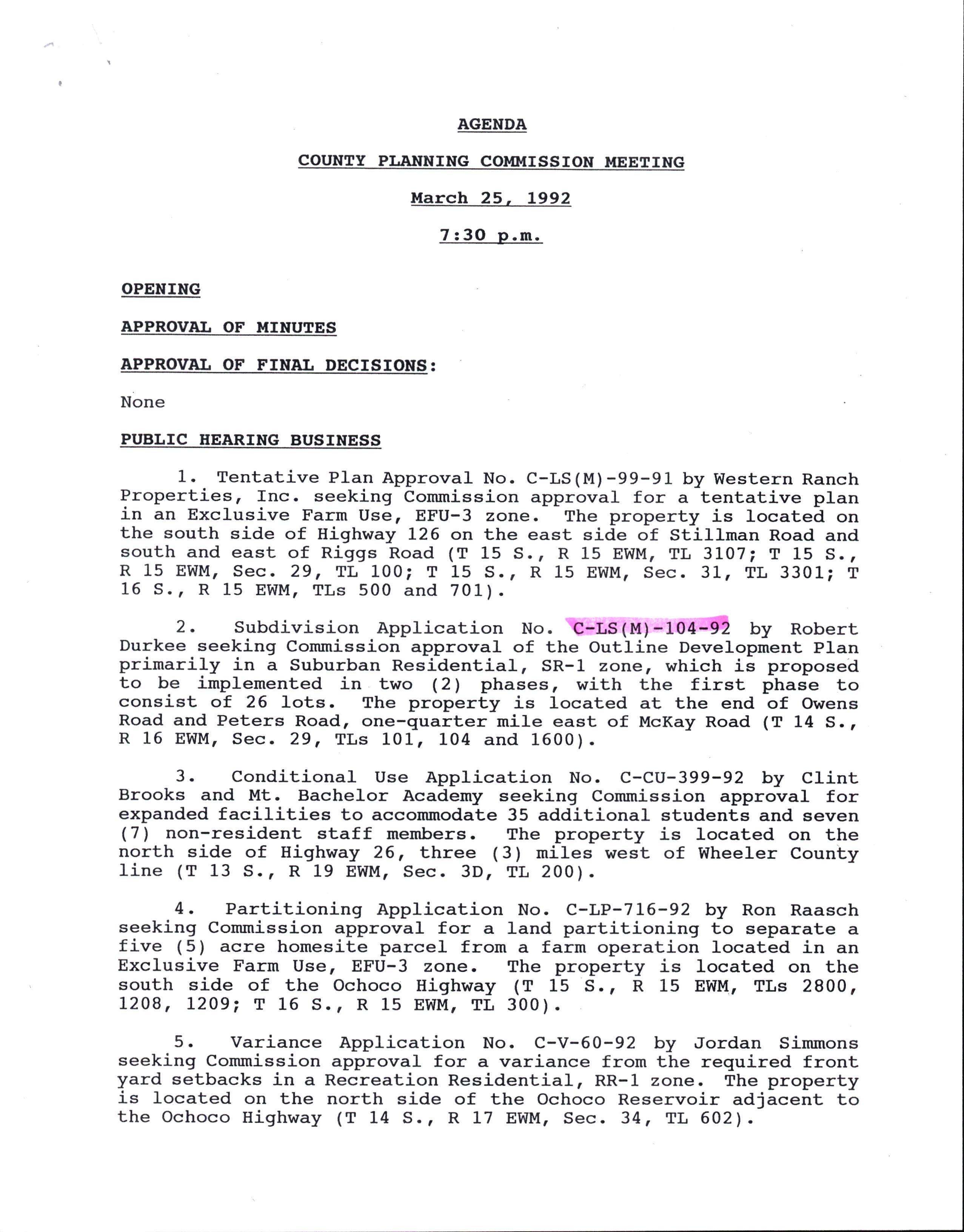
PROPOSAL: Submission of an Outline Development Plan for a rubdfion primarily in a Suburban Residential, SR-1 aoruet which is proposed Lo be implemented in two (21 phases. A detailed plan has-beEn submitted for the first phase, to consist of 26 lots.
APPTICATION DATE: JanuarY 15, L992
PROPERTY OltltER NOUCE: February 13, L992
PUBLIC NOUCE: llarch 10, L992
StBDMSfON REVIEW COMMITIEE: February 27 t L992
EEARING DATE: Irlarch 25, L992
EISTORY: Tax lot 1600 was the subject of partitioning no. C-LP557-87, approved in April I L987.
ACCESS: The applicant proposes to construct an extension to Owens noaa ana a connlcting road (to be called Northridge Road) to serve the first phase of the subdivision. He propose_s to extend Northridge {oad to serve the second phase of the developme_nt. TIr" extensioi of Northridge Road may connect to Peters Road to the south. AIl roads arL to be constructed to County standards. According to the Crook County Road Department, Owens Road will need to be widened to at Leas1u 22 feet to accomnodate the expected traffic volume for the first phase of the project. Paving will be required. A bridge on owens Road is rated at 18 tons.
TERRAIN: The northern part of the property hal= st-eep slopes. The souttrern part of the property is more nearly IeveI.
ACREAGE: The property measures approximately LL6 acres. The first ptrase of the -pro-posdd subdivision is to occupy approximately 40 i"r"r, and thd s6cond phase is to occupy the remainder. Lots in the first phase are proposed to have an average size of one (1) acre.
of irrigated lands used for mint cultivation. Part of the property is nonirrigated and has been vacant or used for low-density grazing.
AREA LAND USE: The property is bordered on the west and north by smal1 (five to ten acre) non-farm parcels. Larger (401 acre) parcels-which are vacant or in agricultural use are located to the Last, south and southeast. Eudspeth's Reservoir, which has been designated as a natural scenic buffer area by thg C_omprehensive Plan is located a short distance to the east of the property. Barnes Butte, also a short distance to the east of the property, has been designated for scenic Preservation-
FARTI DEFERRAL: The property is on farm deferral.
IRRIGATION: The property has approximately 23.4 acres of water Fgtt= f="m the Octroco Iirigation pistrict. An existing L2 inch OID pipeline enters the property from the north and connects to an exisling delivery pond on the northern part of the property. Th9 pipelin6 continues- south to deliver water to another p_roperty^$d loirnects to the Distribution Canal to the south, according to OID. The applicant proposes to fill the deli-very _poqd and replace it with a pumping station on the north edge of the property.-- .Be p=opor".: td ailtribute the existing water rights among the !il"! ltrai" subdivision lots, with the lots to receive an average of 0a9 icres of water each. The OID has expressed concerns about the proposal, and state that the applicant-must obtain approval-f1om tt"i for any changes to the existing irrigation system or provision of irrigation water to individual lots-
FLOOD ZONE: The property is not in a flood zone.
FIRE PROIECIION: The property is in Fire Zone II. A minimum road width of 22 feet will be required for access.
UIILITIES: Electric and telephone lines are to be undergroundResidences will need to be constructed within 150 feet of the front property line for access by electric lines.
I{ATER: Water is to be provided by weIls on the property. Thg lppEcant proposes to prbvide watei to lots north of Owens Road fiirm party we1ls, with-individual wells on the other lots. Test wells-wifi Ue needed to verify water quality and quantity.
SEPIIC: Sewage disposal is to be by individual septic tanks' eecause of ste6p slopes on the northern part of the propertyr-the proposed lot sir"s rn"y be too small for adequate drainfields. Larger lot sizes may be needed.
Robert Durkee
Northridge Subdivision
C-LS(M)-104-92, Staff Report
Page 3
ZONING: The property is zoned Suburban Residential, SR-l, except for the northeast corner of tax lot 104; which is zoned Exclusive Farm Use, EFU-2. The small portion of the property which is zoned EFU-2 constitutes a part of proposed subdivision lots I and 9. The property lies within the Prineville Urban Growth Boundary except for the portion of tax lot L04t' which is zoned EEIJ-2. Under Section 3-.080(3) of the Land Development Ordinance, the Tentative Plan for a proposed subdivision within the Urban GroWth Boundary must be submittLd to the City of Prineville Planning Couurission for review a4d approval prior to approval by the County Planning Conrmission. T-his requirement does not apply to Outline Development PIan approval.
LAND DEVELOPI{ENI ORITINANCE:
Sections 3.010-4.L20 of the Land forth requirements for subdivisions. Sections 7.OLO-10.020 set forth street, design, and improvement standards for subdivisions.
COI.IpREEENSM PLAN: The property is identified for residential use Uy ttre Crook County-Prineville Area Comprehensive PIan, except foT tlre small porLibn in EFU-2 zoning, which is designated agricultural.
policies for residential areas in the Prineville area are set forth on pages L25-139, while policies for agricultural areas are set forth on pages 42-49. Scenic area policies are set forth on pages 113-L19.
DISCUSSION: The smatl portion of the property which- lies in BFU-2 zon-rngandoutsidetheUrbanGrowthBoundarycannot-beinc1udedin ttre sribdivision unless the zoning/urban Growth Boundary is changed through action of the County Court, and the Prineville -City Council. Alternatively, this small part of the property could-be conveyed 'to the adjoining property owner - ttrlgugh lot line adjustment, or partitioned ott to forur a nonbuildable parcel which would not be a part of the subdivision-
Gordon Planner
GM: dks
Fee $200.00 plus $10.00 per proposed ].ot
COUI TT OF CROOK
. CountY PJ-anning Corrunission
PRELIMINARYNo[tcEoFINIENTIoNFoRSI,BDT\rISIoN
App]-ication No- C-LS(M) toA-q?
This form must be filed for any d'ivision of land into four (4) or more parcels being ofterEa for sale or lease. Brief instructions are incorpoi;a"din_- tlre fornr und-er ttre appropriate treiaings . _c&ilii - ttt"' Planning Department for furttrer d.etails. Applications must be filed with ttre plann5-ng. p.piit "nr it f"i=t 21 days priol to the Planning Commission .*;;i;-at-wtrict -""""iO"iati-on'is desired to and' shall lre accompanied rv -iirteen-. -( 15 ) copies of. -'the pi"fi*i""ry- Pi;a-^ip and' appropriate filinq fee'
NCIIE: To bomplete the form, 1.goPY.of the Crook County Subdivision ordinance ($5'-O-0) would be hel-pfu].'
AnsweraJ-J.questionsintheform.Leavenoneb]-ank.Ifthe question i= rr"t-ippri""ur",-wiitg ".,g:. applicable" - Attach the required d.ocuments "ia-'-fiie with Lhe County Planning Department.
Notice of Intent
1 TlWe the Crook of of in boundaries of Crook County, Oregon'
By: Auttror Agent
2. Genera]. Informati-on
A. Name or ProPosed name of develoPment
B. zu]-]. name of owner of record
C. Business Address Residence Address * tt 7/u
D. If a corporation, narne and address of offi-cers -
If a partnership or joint venture, names and -.aa.L==es of tir. *.i.r ers zflJ ,'- *; D "t rzt<€-d
F. Agent of owner, if any; name and address -
G. Fu1-I natne of develoPer
Resi-d'ence Ad'd'ress -
Business Address development. Real Estate ticensee
Name I. Location of sales records ( state the add'ress at narne of custodian)
RealH.Listbelownamesand'businessaddressesoforegon Estate licensees and. other persons who will be engaged in sales and. promotion of lots or parcels in the proPosed' S ot which records will be kePt and'
J. Pleasefurnishttrefol]-owinginformation: purchasing ( 1 ) Descrj.be what financing plan was used in (2lDescri5ewhatfinancingplanistobeused'in financing oei-site improvements CA-s 11
(3) Descrj-be what plan of financing is to be used' in constructingr onlsite improvement CASH
(4) and by whom Descrj-be what plan of finalci-ne is !o be used' ![--if,;- "ii".ing or parcers for saLe in this development CA.S/1 at- /Y74 hz
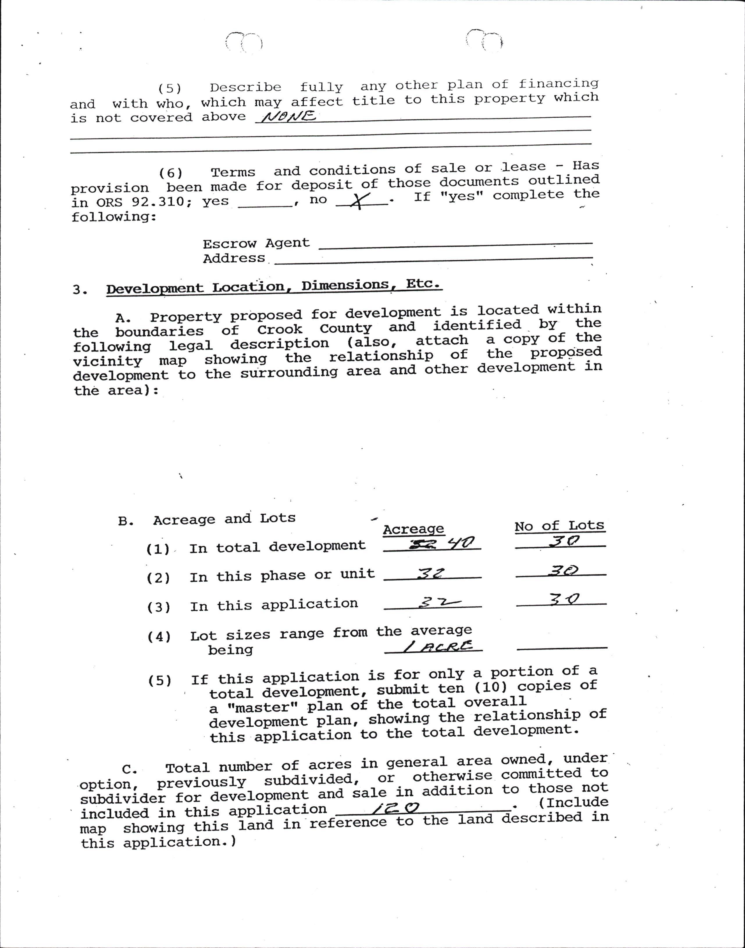
(5)Describefullyanyotherplanoffinancing and with who, which may affecl title to this property which is not covered above
( 6 ) Terms and' cond'itions of sa].e or '].ease - Has provision been made for dep"=it "f those documents outlined in oRS g2.3LO; yes _,';;---i- . rf ''yes" complete the following:
Escrow Agent
3 . D"rr.Iopto.ot l-..tioo ' Di'o.etr=ioo=, Ett '
A.PropertyprbPosed'ford'evelopmentislocatedwithj-n the bound.aries of Crook -i"""t' aira id'entified - by the following feilf -a.""iip_tiott (a-Iso,attach a copy of the vicinity map= ;ho*irrg tt "---t"iitioistripof -the- propcised development to the surto,rr,Iit g-;;; and' ather develoPment in the area):
B. Acreage and Lots ' Acreaqe ( 1) In tota]. d'evelopment R' qa
Zzfrom the average
No of Lots 3A 3 o owned a under committed to to those not ( Include
2r)
( 4 ) Lot sizes r€ullJe being (s) (21 In this Phase or unit (3) In this aPPlication If this aPplication is for onJ-y a-portion of a total aeverliil;[,-"t'b*it ten (10) copies of i-,imaster" ;i;; oi ttre total overall d.evelopme"t=;I;,-"ttot'ittg the :eIafiolship of trtit-"irpricat'i"t'' t" the total development' in general area or other:vrise a in add,i-tion sale to ibed in
3.
Deve].opment
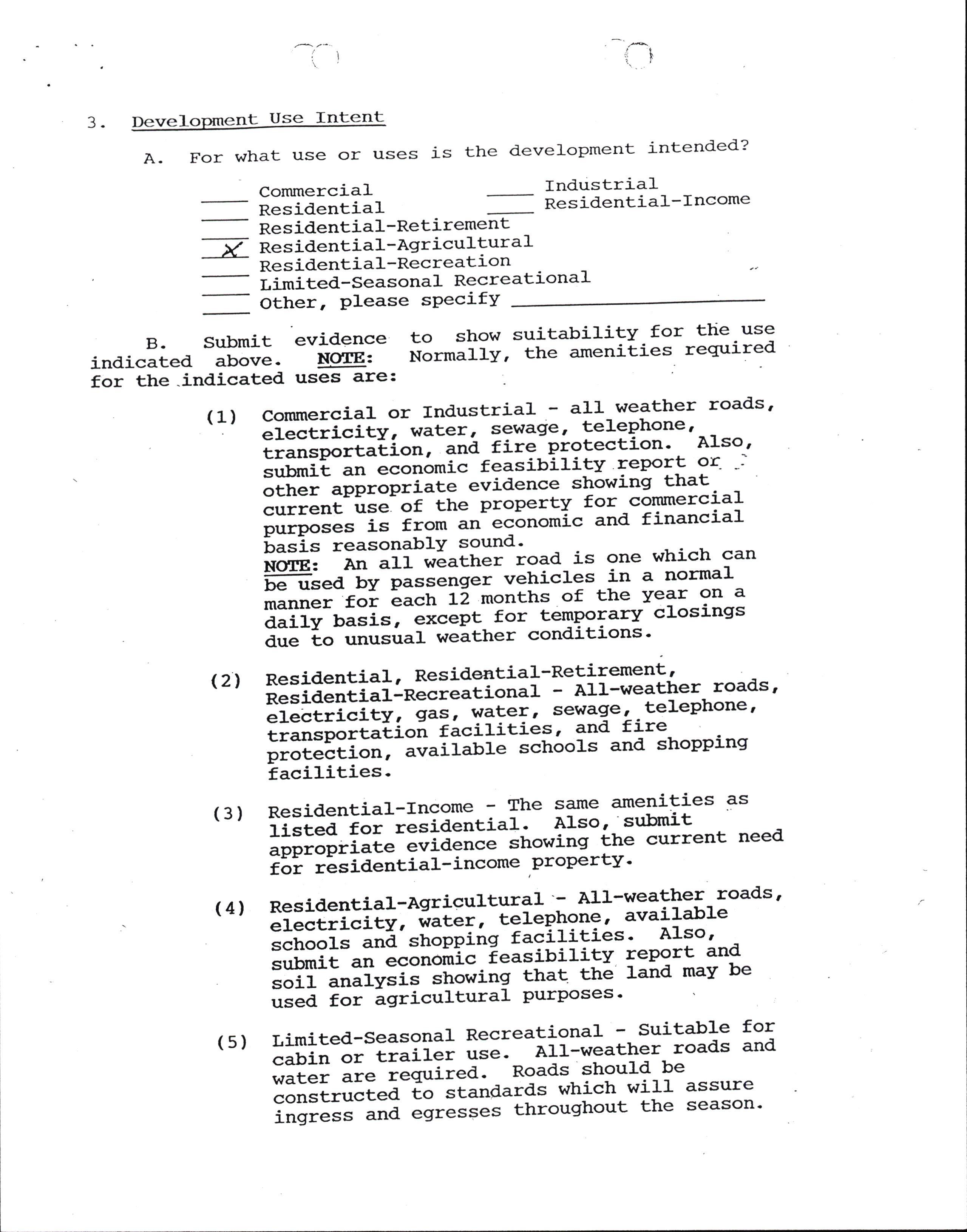
Use Intent
A. For what use or uses is the development j-ntended? commercia]- Industria].
Res identia].-Retirement
-V Residential-Agricultural Res id-ential-Recreation ii^it a-seasonal Recreational Other, Please sPecifY
indicatedB.Submitevidencetoshowsuitabi]-ityfortheuse above. Ncl(fEt iot*iiry' the amenities required for the .indicated uses are: (1) :iu::i:it :"I*l:'::*i,",'llrx;f,:*: roads' tii"tp"tt"ti""l -;a -f ire-protection' . A:-so ' sr:bmit .tt """t 6,ni" feasibility lepor-t or- -l other "pptopiiate evid'ence showing that currentuse,ofthepropertyfor-commercial iltp";;= is from an economic and financial L"=i= reasonablY sound' No{fE: an aif wEather road is one wtrich can ffi;"d Ev-p.t"""g". vetricres in a normal *"r,rr"t foi each L2 monttrs of the Year on a a"iiv riti"l-"""Ept for tempoTary crosinsrs due to unusua]- weather conditions'
Residential-Income - The same ame-nities as listed. for resiaentiaf' Also''submit aooropri"t" "iidI"""-=t"*ing itre current need' r5i- iEiid'ential-income,propertv'
(4)
Resid.entj-a1-Agricultural'- A1.J'-weatlrer- roads' electricity, ;;G;, ielephone' avai]-able schools ana stropping facilities' Also' submit "r, ""otJiliE--ieis:-uilitv report and' soil analysi='-"ft"*i"g that the 1and may be usea for igricultural PurPoses
timited.-Seasona1 Recreational - Suitable for cabin or traiil; ;;;: All-weather roads and water u't" t"q'ired'' Roads shou1-d be ;;;;L""ted io standards which wil]- assure ;;;;;; ana egresses throushout the season' (s)
Submit a statement relative to the methods or provisions to be used to assure that parcels iriff onlY be used as intended'
Are there any covenants, conditions' restrictions to be used?
Yes No or A
B If soe submit a copy of -restrictions or proposed restrictions [o-Ul-*sed' for review as to content and IegaI sufficiencY'
A. GeograPhical location of develoPment s7o € I?n o- u
How manY miles Prineville? by CountY or State road' from B.
C 1 sll/l t
TopograPhY -iit"-llv6r, rolIing, hilly or rockv?
(21 List all ]-ots cut bY eros].on oAt ta-
D. Drainage (1) rs land subject to flooding? at (2'l APProximate ]-eve]. of water point
(3) Are fic drains or storm sewers to be instal]-ed?
(4) r SO, at se expense?
E. Soils
Most cornmon soils series found' on ProPertY t (1) (21 (3) (4) (s) (6) (7) (8) Average slopes (t) Drainage: F Excess Poor nunot[-*-RaridMed'ium &.!low i"rmearilffi -L nEFffi Moderate SIOW t snrinffirl-i"t""tia1: L towMedium Hiqh erosi6nf,T "ii-a='Z -.Y tow Medium High AveraleTepIt, t" hard'pan or bed'rock 71. inches x a
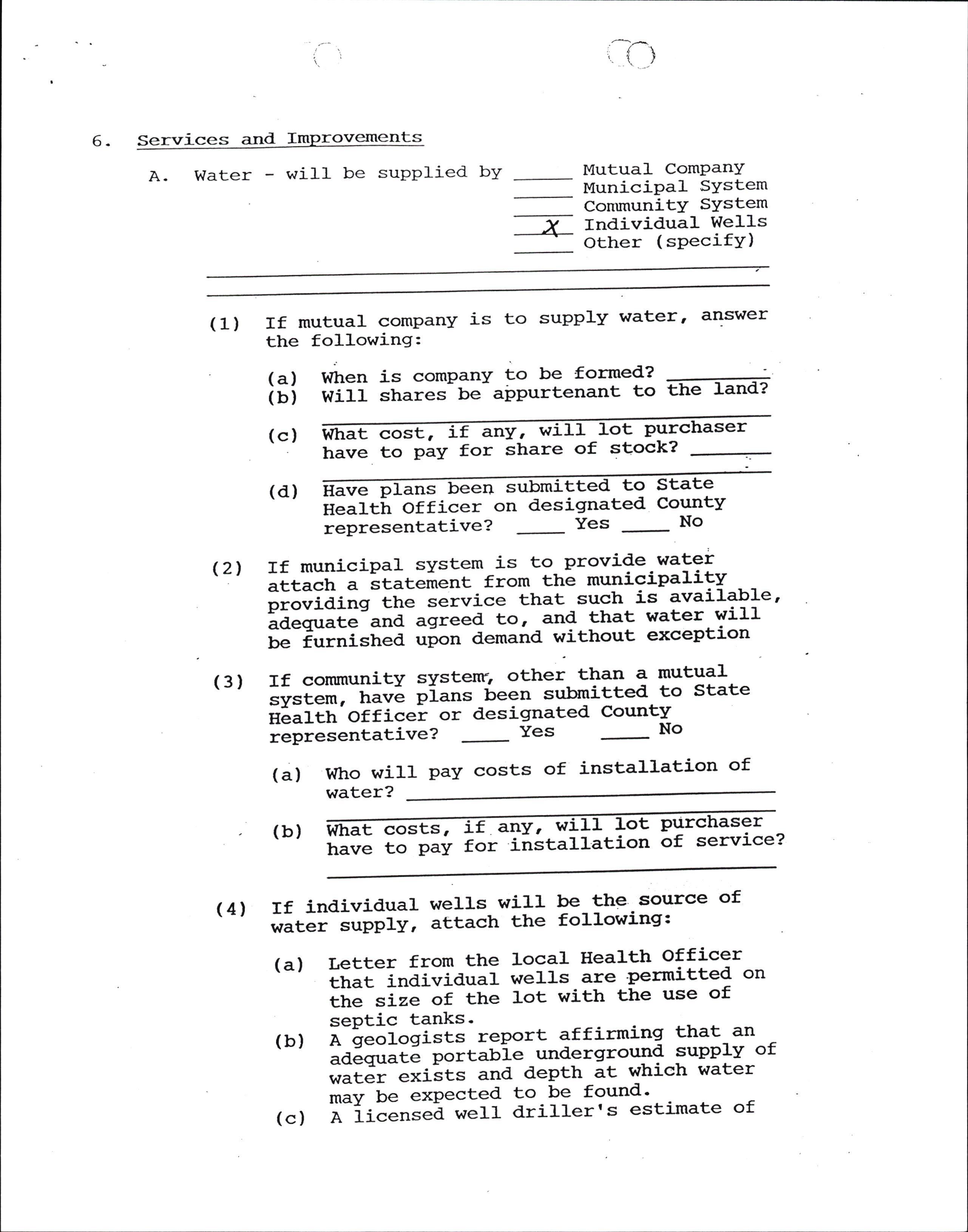
6- Services and. ts
A Water - will be supplied byMutual- Company MuniciPa1 SYstem Contmunity SYstem Y Individual Wells +other (sPecifY)
If mutual company is to supply water' answer the following: (1)
(a) (b) dt "rr' is comPanY to be fotmed? wiJ.l shares be airPurtenant to the
(c) what cost, if any, wi]-]. ]-ot purchaser have to PaY for share of stock?
(2',/.
(3)
(4)
If munici-pal system is to provig".wa!9l attach a statertent from the municipality pi""iai"g the iervice that such is available' iA"q,rit" and. agreea to, -and that water wilJfe iurnished "p"" demand' without exception
If community systenr, ottrer than a mutual =v=i"*, have pi..r= -been submitted' to state nLalth'officei or desigrnated County i"pi"=""tative? -Yes -No
(d) Have P t Health officer on d'esigna representatj-ve?Yes water?
(b) 6at costs, if any, wj-II ].ot
(a) Who will pay costs of installation of to State ted CountY -No have to PaY for installa tion purchaser of service?
If individual wells wi].l be thesource of *itEi suPPlY, attach the following:
(a) tetter from the ]-ocal Health officer that inaiviAual weI1s are permitted' on the si-ze-of the Iot with the use of sePtic tanks'
(b) a -geologists report affirming that- an ad.equate-p"ittrie -underground 9upply of water exiits and' depth at which water maY be exPected !"-P9 found'
(c) A license-a weff driIIer's estimate of
(d)
(e) cost per foot to drilt and case a wel1 and depth at which water may be reached' a suppliers charges for ttre sal-e of a pump and Pressure sYstem and installation costsCertification from ttre ].oca]- Hea]-th O"p"tt*"nt that water is potabl-e for domestic use.
Dis sewer, - will be ed (B)
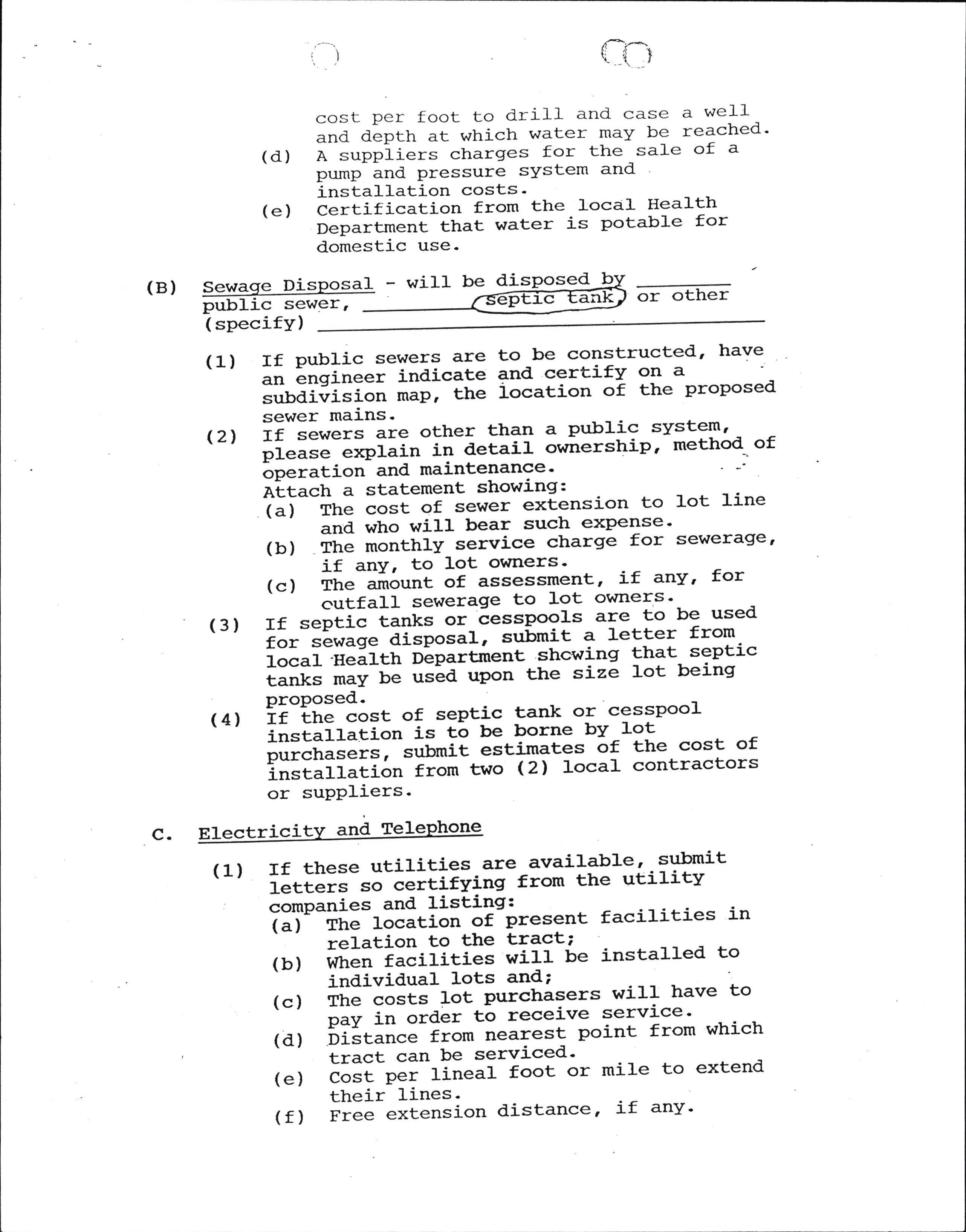
( specj-fY) or other
(1) If public sewers are to be constructed' have \ - ' .n Lngineer indj-cate and certify on a su.lrdivisi;; ;;;; the iocation of the proposed' sewer mains.
(21 If ="r".= are other than a public system' please "*pi"i" ir,r detail ownerstrip' method' of oPeration and maintenance' Attach a--siatement showing:
(a) The cost of sewer ex['ension to lot ]-ine and who will bear such exPense'
(b) The monthly service charge for sewerage' if anY, to lot owners'
(c) rne-airount of assessment' if any' for outfall sewerage to J-ot owners'
(3) If septic tanks or cesspools a1e. to be used for sewig"-di=p"sa1, submit a J-etter from loca1'Heal.th Department shctring that septic tanks *;t-G t'=La upon the size lot being ProPosed-.
(4) If the ""=t of septic tank or cesspool instal.l.ition is to be borne bY Iot purcrrasJi=l--=G.it estimates ot ttre cost of installation from two Ql IocaI contractors or suPPliers'
c.
Electricitv ani TelePhone
(1) If these utilities-are available' sulrmit :-etters ""-EEitifving from the utilitv comPanies and listing:
(a) rrre-focition of present facilities in relation to the tract; (b) wft"n-iacilities wi]-l be insta].].ed to individual lots and;
(c) The-costs 1ot purctrasers will have to P"v i. ord'er to receive service '
(d) oiitance from nearest point from whj-ch tract can be serviced'
(e) ""!I-p"i--1inea1 foot or mile to extend their lines'
(f) Free extension distance' Lf any.
(21
(g) Guarantees or cond'itions which the companies wiII requi-re in order to have their lines extended' If electricity or teJ.eptrone is not available ry extension 6r ]-ines lnd service may be supplied nV """tfrei method', describe fu1ly the syst"* .td submit costs from suppliers' ;&"#.; with f ranchises, permits ' ]-icenses ' et6., which maY be required'
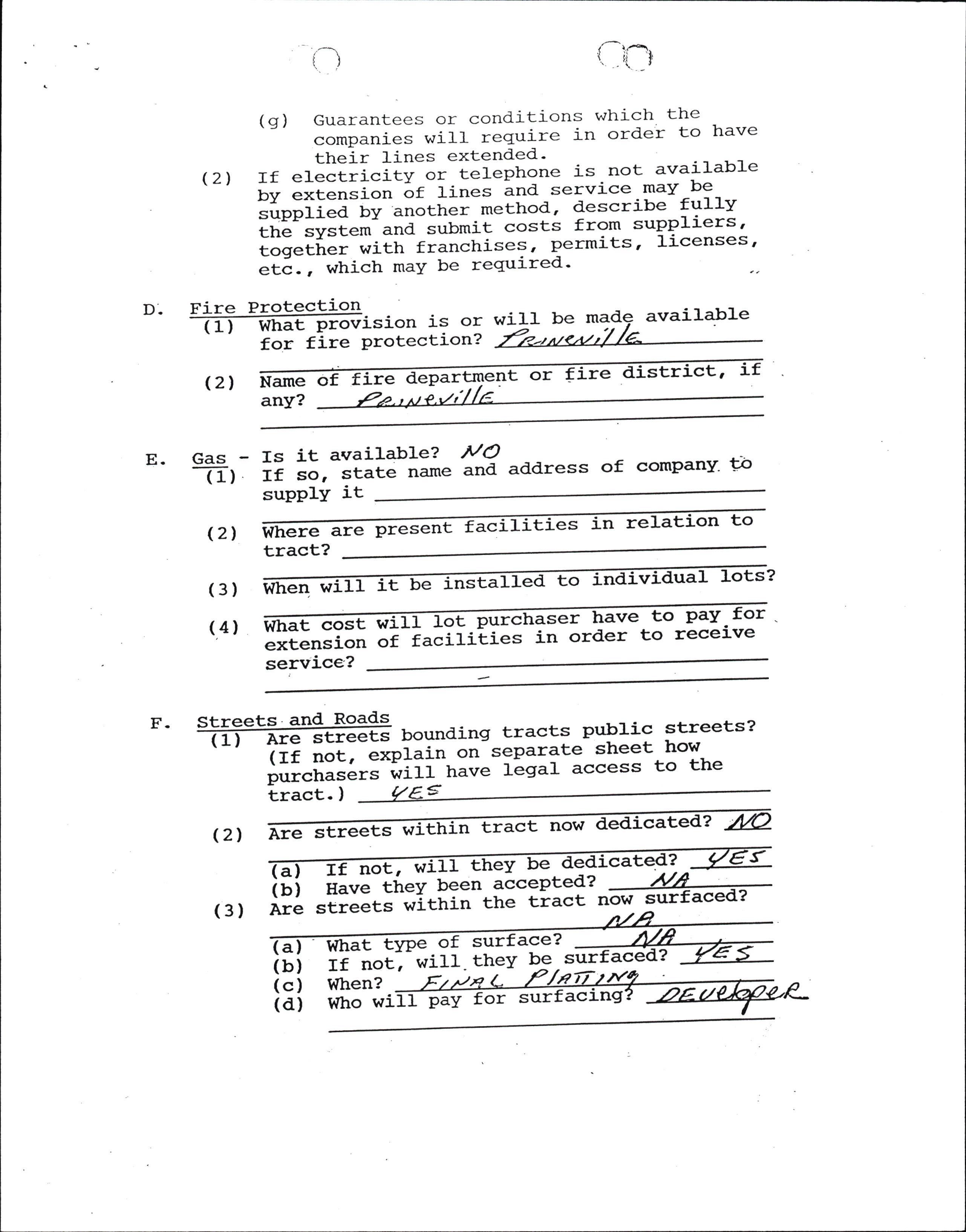
D- Fire is or wil]- be avai].ab]-e (r What for fire protection?
(21 Name any? f nt or .are tr t, ?a
E. Gas Is it available? ilO ad.dress of comPany- -to T) If so, state name and supplY it are presenFf acil .es n to (21 tract? I tbe ta to 2 (3)
(4) what cost 1 lot Purcrtraser have to pay for extension of facilities in order to receive service?
Er tracts PubJ-5.c streets? seParate street how lega1 access to the
(21 Are streets w tract now bated? will they be 2 r (a) If not, been accePted'nk (b) Have they (3) Are streets within the tract a b c d ) ) ) ) tlrPe of surface? ( ( ( If not When? , will. theY be aceda Who wi pay or
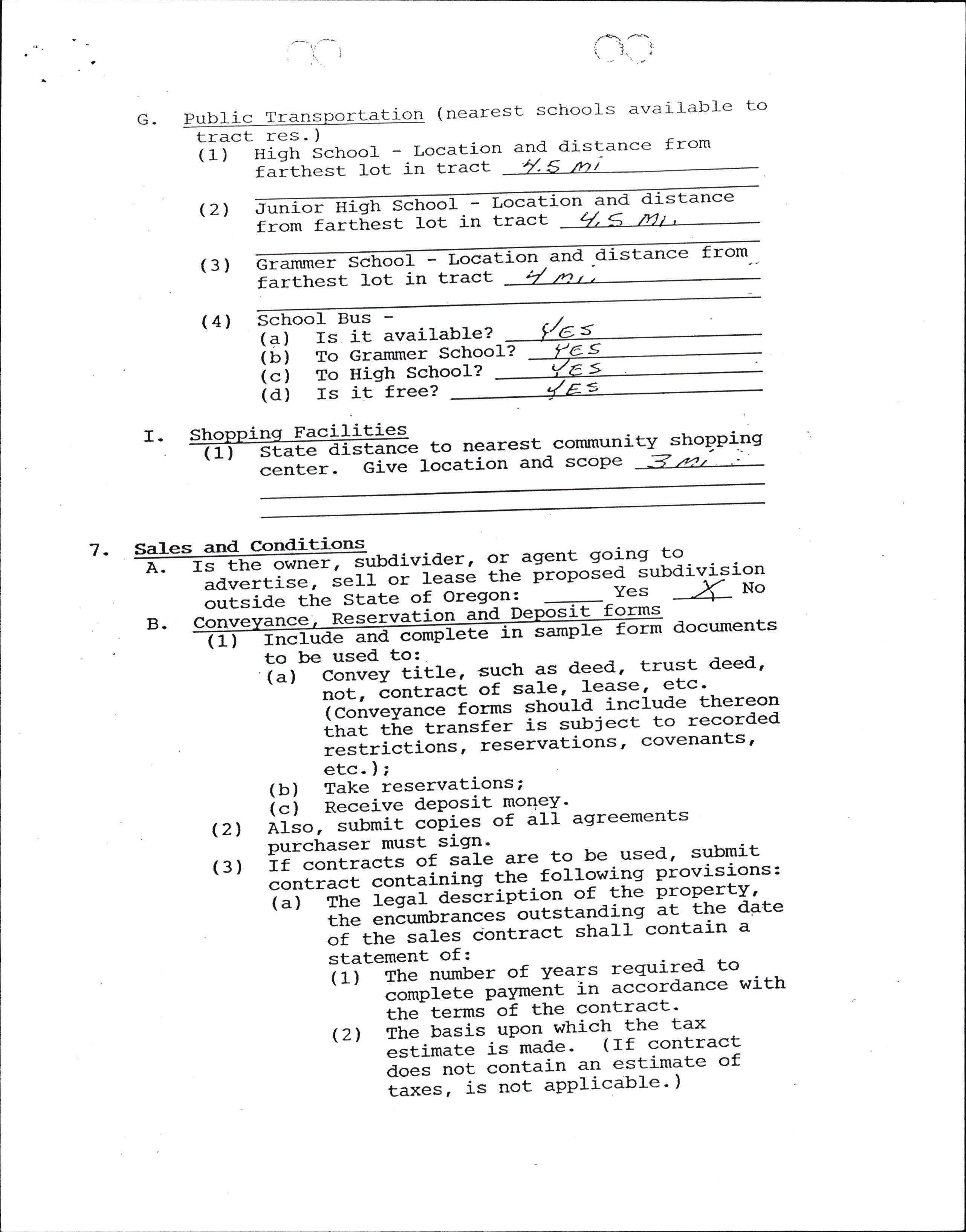
c. Public ansPortation (nearest schools available to Tr tract res. )
(1) Hiqh Schoo]- - Location farttrest Iot in tract and distance from
High
(2) Junior from farthest lot in tract oI Locati-on and distance
(3) Grammer S farthest chool - Loca lot in tract ti-on and stance from-. tt)r,
(4) (r State center. Give Schoo]- Bus(q) Is it available?
(b) To Grammer Schoo (c) To High School? I? to nearest commun location and' scoPe
S S I (d) Is it free? F i1i ,es tance ity shoBplls = 4<1 t
7. and Is owner, sufaivider, ad.vertise, seII or outside the State
A.
B. sit forms
l_ or agent going to lease the P,roposed subdivision of Oregon: Yes ^( NO
Inc]-ude complete samp form documents to be used' to:
(a) convey titfe, such as d'eed'' trust deed' not, "otirt"t of sale' J-ease' etc' (Conveyai""-i"*= should' incJ-ude thereon that trre"Ilan=i"r is subject to recorded restricti;;; reservations' covenants' etc. );
(b) Take reservations; i") Receive dePosit ToqeY' (21 Ai;",- ="r*ii "oii"s of all asireements porctt.ser must sign' 1, submit (3) If contricts of sale are to be usec contract*IJlt"i"i"q ttre ro[owing provisions: (a) tn" ilgir-E"""tiption of the propertv' the encurnbrances outstanding at ttre date of the sales iontract shall contain a statement of' Lred to (1) The number of YeaTs requ: complete p"v*"it in acCordance with tn"- t".*s-of the contract' (21 tii" f"=is uPon which-the tax !tU-*"t" is mad'e' (If contract does not contain an estimate of a;;= , is not aPPlicable ' )
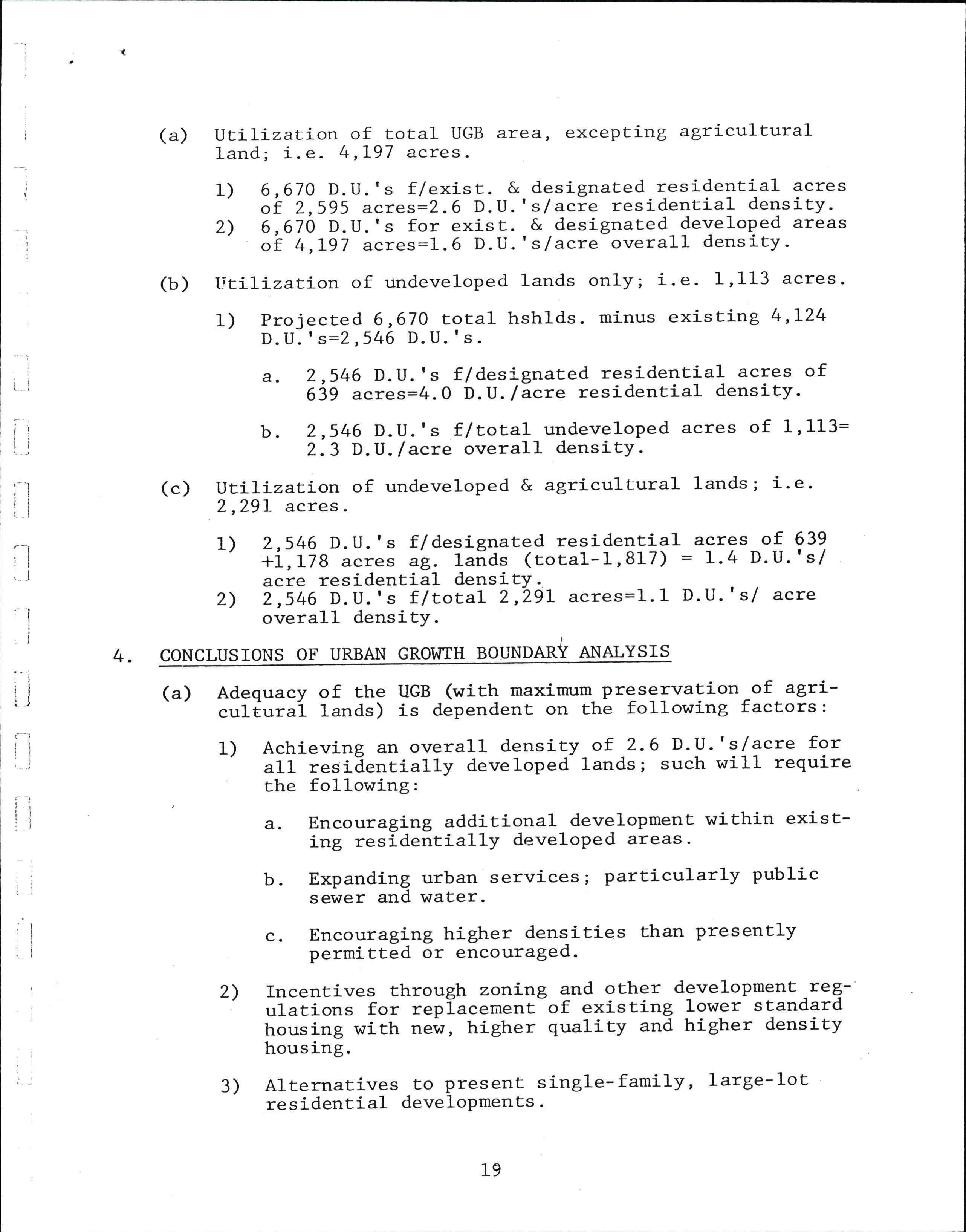
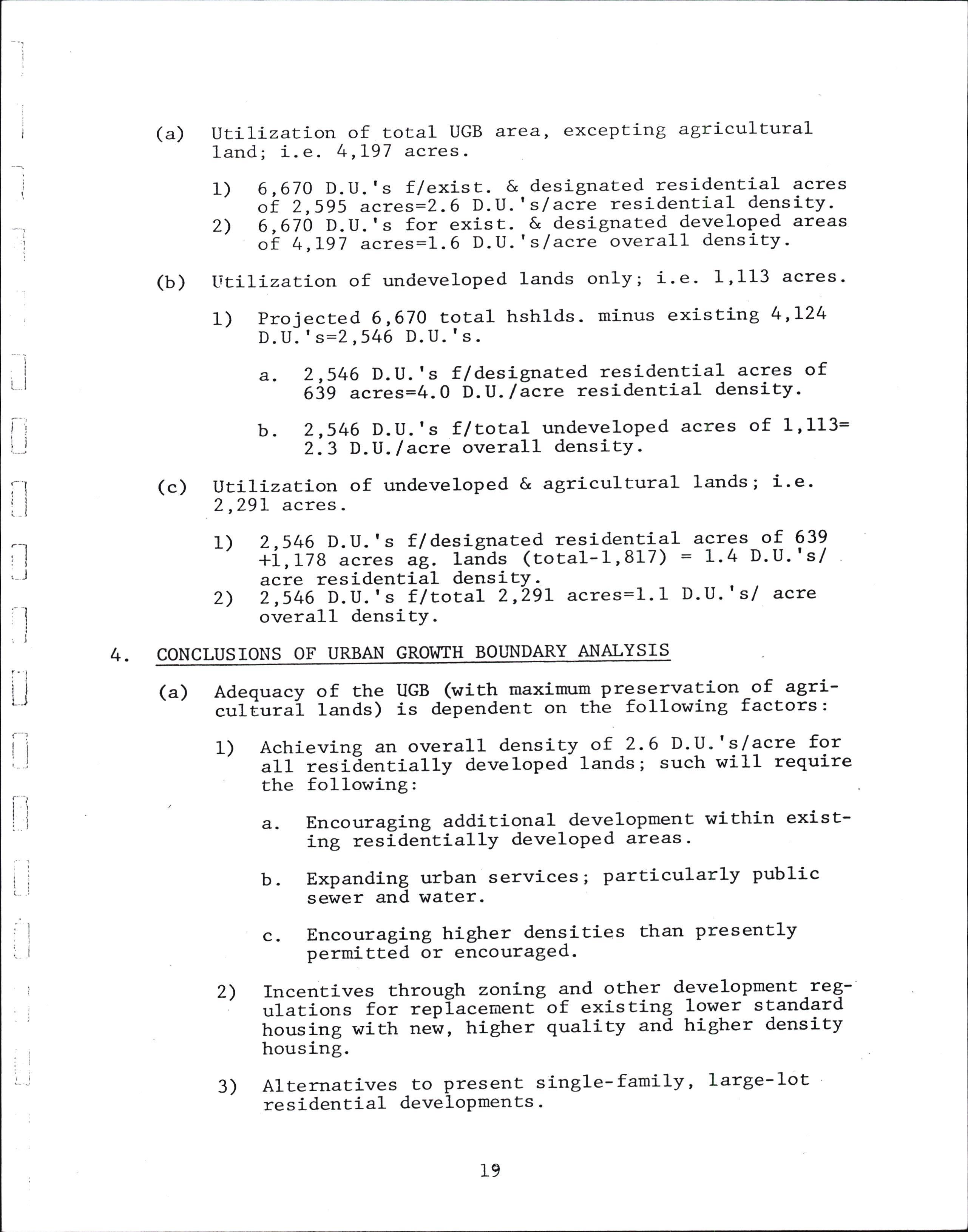
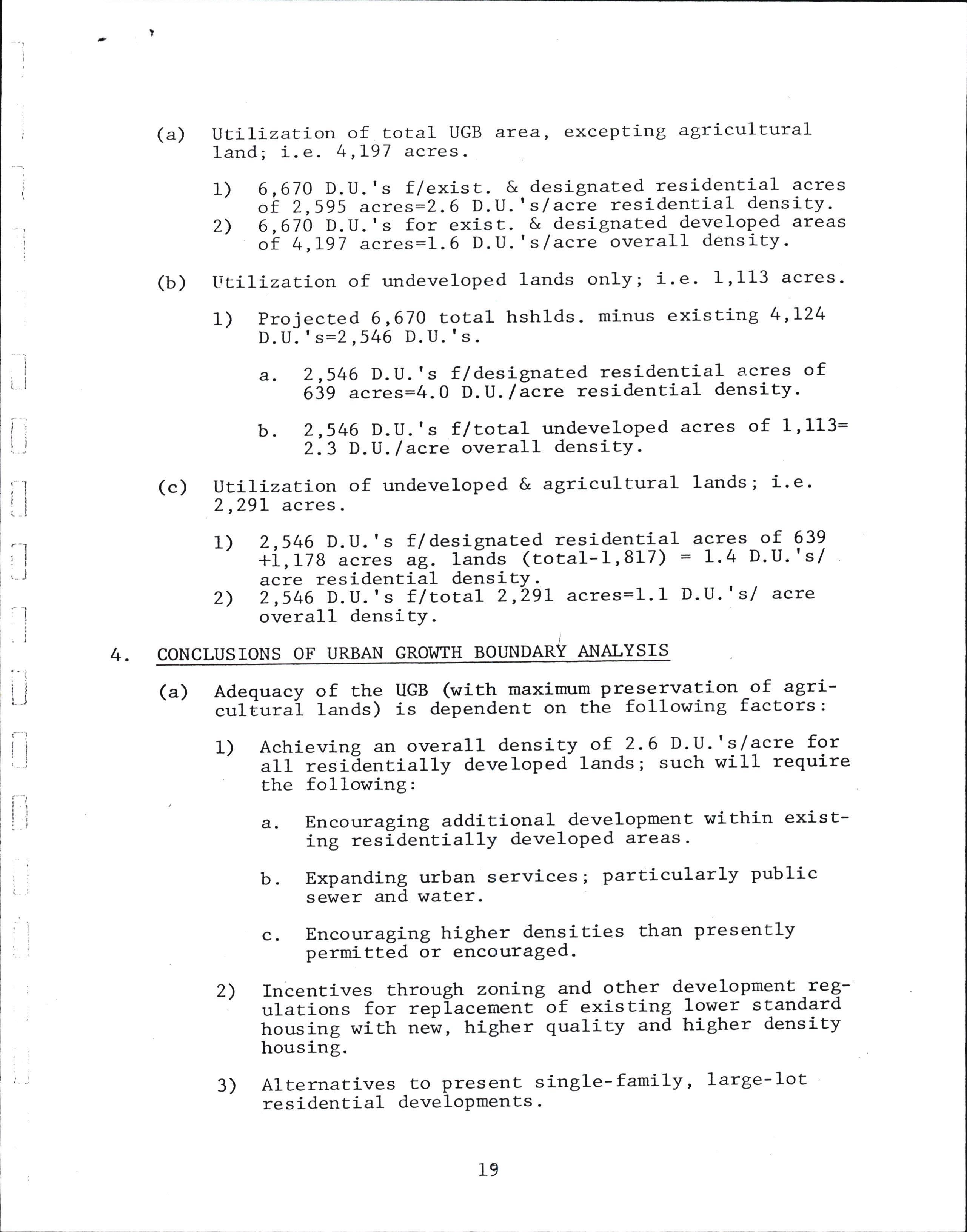
(a) lJtLLLZaxion of total UGB area, excepting agricultural land; i. e . 4 ,L97 acres
1) 2) 7O D.U.'s f/exist. & designated residential acres 2,595 acres:2.6 D.U.'sf acre residential density70 D.U.'s for exist. & designated developed areas 4,L97 acres:l.6 D.U.'s/acre overall density-
6,6 of 6,6 of
(b) titilization of undeveloped lands only; i.e. 1,I13 acres.
1) Projecred 6,670 total hshlds. minus existing 4,L24 D. U. ' s--2 ,546 D. U. 's.
a. 2,546 D.U.'s f/des:-gnated residential acres of 639 acres=4.0 D.U. /acre residential density'
b. 2,546 D.U.'s f /total undeveloped acres of 1,113= 2.3 D.U. /acre overall densitY-
(c) utilization of undeveloped & agricultural lands; i.e. 2,29L acres.
(a) Adequacy of the UGB (with maximum- preservation of agriculturai lands) is dependent on the following factors:
1) Achieving an overall density of 2.6 D.U.'s/acre for all resiEentially developed lands; such will require the following:
a. Encouraging additional development within existing residentially developed areas.
b. Expanding urban services; particularly public sewer and water-
c. Encouraging higher densities Lhan presently permitted or encouraged.
2) Incentives through zortLng and other development regulations for replacement of existing lower standard housing with new, higher quality and higher density housing.
3) Alternatives to present single-family, large-lot residential develoPments
4) Provision of adequate public services and attainment of financing therefore.
Section 3- 090. Suburban Res idential ZoYte , SR-1- ln,an S[jf Zone, thq o owrn8 regu atlons shall aPprv
- (1.) Uses Permitted Oucright' In 3n SR-1 Zone' the following uses and- thE-ir accessory uses aIe permitted ouCrighC'
(A-) Single-fanily dwelling' including 1 r'robile home on an individual l-ot in compliance with section 4-130 of this Ordinance] "i-i.- ""o,piir.,"" wich Section 4-L4O if within duly platled and appror"a-r"Uile home subdivision br PUD
(2.) ConditionalUses Permitted. In an sR-l-'zorle, the followin8 use andtheiraccesSory.use""ffid-whenauthorizedinaccordancewith the requir"*"ill-"it-i"rth in' Article 6' Church
(A- ) (8. )
(c.)
(D.)
(E- )
(F- )
(c. ) (H. ) (r. )
(J- )
(K- ) (L.)
Gotf course and other oPen land recreaEional llse,'but ;;;i.eing intensive commercial a:rusement uses s.ch as .,pitch & putti-s"rr course, driving range,-auEomobile "I^io.";.;;i; tI." track,. or amusemenE park-
Governmental.structure or use including Park'- Play;;;;',i..=",tioiuoiraing,firestation,1ibrary or urusetm and limited thereto''
Hospital, sanitarillm,' rest \o-me, home,fg= -the-aged' nursing home oi-.o.,'"1""""..t home' and iedical or dental clinic-
Schcjol or college-
Utility facility necessary fot public s.ervice
Mobile hone subdivision or PUD and urobile homes on individual rocs-;;-;i;gi"-r"u-ry_ dwelline gl-lgtg not in ;;i;;1".."a-""e ;il;;"ed nobile houe iubdivision or PU suUjett to subsectiirn (S) of chis section'
Mobile home Pa=I-
Eomeoccupationscarried.oo.by-theresi.dentsasaII ""E""""rT use within their dwe1ling, a EaTage, or tJater supply and sewage treacment facility'
t'{u1ti-familY dwelling' i
Privately operated kindergarten o1 d3f fluriqfy; Provj_ded tt e resioencial chaiacter of ttrL building is nraintained-
(3.) LimiraEions on Uses. Th. following |imil:cions of uses permirt.ed by ffi this section sfial1 apply: ' ' (a-) cows, horses ' sheep "= ffi::'23:363t'F"::'!.!t,t::: - having an area of less under no circumstances "it"if they be kept for cott'mercial pttplI"" ' The t"tli*i"-ue-r'of a}l such animals (other ctran-Ltteir youni*;te; the age of six months) allowed on a }ot st,a11iJ..ri*it"a c" the square fogt,age of .il'i i"i"ii+ia"a bv rhe total ruinimum aTea Teqrrired f"; il"tt-"timal a-s listed below:'
Ilorses Cows Sheep
(8. )
(c. ) (D. )
(E. ) (F. )
20,000 sq-
20,000 sq20,000 sqfx. ft area area area of of of ft
The number of chickens'-fow1' and/or rabbits over the age of =i* *ooliir,--"t"ir ool',exce"d o,,e (1) for each 500 square -t"tr of ProPerry'- The nuutber of young chickens, ,oril liai"i'i"uf irc (r:nder the age of six months) allowla ;;-ti; ;TF;;y at anv time shall not exceed rhree ;ilx;; iii" !116r"uie numbLr of chickens, i"irl-".-iio, ;#;it;";;-;he age of six uonths'
The number of colonigs of bees al1.ow-ed-on a 1ot shall be limited ." Iii-(f)-"of"oy for each 1'000 square feet of lot area'
Animal runs or barns' chicken or fowl-Pens' and colonie of bees shall'b"e-i"""r"a -"rr-tt " .rear E-alf of the property PYt ";; ;i;;;; tt'an-io feet from the front proPerty' rr-rr"- rror closer than 50 feet from any residence
Animals , -chic\e'" t- i:d{::. fowl sha1l-b"o3';:ffllti35"u or housed, and proper sanitation sha1I' ar all ti-mes ]' toi;";i;J-;;-pou1try ffid shall be srored in mecal";; ;h;;-r"a"irt-probf recePtacles'
No other-livestock'excePt for domestic dogs and cats are Pe:cmitted'
(4. ) ' Lot Si-ze. In an SR-l Zotte ' the followj-ng 1ot sizes shall apply:
(A. )
(B- ) For a single-family dwelling-""tY:9J1--P"th an aPProve comr:nity, #iH;ir-li-p"uii" t't"I^=I:t"m and an aoproved "o*"ttiii;:;I^i"tii" ""o'erage system' the mini i""..-;;;; tt,"ril'u"' s' oob ssuare feet
For a rwo-family-dwelling :gl'"d Pl b:P an approved comnunity, *'oilipal or public water system and an *1ffi*;;:?rliri":il;*I+ :,as"il3::"'I:::T''che
(c.) (D.)
(E- )
For a single-family dwellins not servgd by either an approved .o*n"-"'ity, municipSl or public wacer system or an approveo .o**"'ity ot pi-tuiit =L'erag" syscem' the rainimum lot ";;;'";h;ir-u"'i:0^;';" (43'560 square feetr) '
For a single- family- dwelling- t"t':9-bl.':tt approved conrnuni ry; ,;;;ipir -;; p;bii:r'3:"; j1i:"3#:+:tsys rer served by an approved co qrnunl!y--3t" l:";;-";;;;;;e- -' or a single-f;Lii;"ilti1i;g--""i-'"a bv an approved community or public ""o'"t'f"-svstem tut not served by an apProved ctumunity '- rnnrni"ip-al or public waEer system' the minimum r;;;;;;' =n"[-u"' 20'000- square feet' '
For a two-family dwelling .served by an aPPr:Y-"-1,":H1i:' or pubJ.ic ""r"iigt sys:em buc'not ty an approved coumum municipal or pu-blic water-system' or ? rwo-fart'i Iy dwelling servLd by ap "pp=-"{r"a-comunitv. rarnicipal or public aracer "v"il* but- not by an approved comruniEy or oublic ""r"t"!I-!i"t""i; ;h; iioi"n't i"t area shall be )o,ooo square feet
(F. )
(c. )
For a t\ilo-family dwerling.not.served by eitJrer an approved "o*ot'ity, municipal or public water systen or an "pp=o.rJI--""i'it""i-ty-oi prnrlit sewerage system'rhe minimr.m il.'IilI"!ti:-i'u'"Jlo-".t" (45;56-0 sq' ft' ) '
For' a uulti-family dwelling I"Y11q-?::-storv and not served by either Ln "pp'o'Ed comunity ' mudicipal or public'rnater svstem, o= ti=IpP;;a-16rtnt:rtiw br public serilerase "y".3ili";t;.iioi'u* iot area shalL be 1'0 acre (ar , soo'lil il:);i*" J ' 5oo square feet for each Eit"rri"g'.,nit ot'"= t*o (2)'
(II. )
(r- )
For 'a multi-fanily d-w911-i1q ttrri!-hl::s more than orre story o,a r.oi*I;;'"a uy ei[trer an appr6ved cou'munity' utrnicipal or public t"::: system or an approved cotmnr:ni iro' Ill: ", ?i*;a;i - f i ::il 4; :HBtBr-E:"" H:'=t31' o i""t -a"e1iin;-u"it'ot'"= r*o (2) '
For a multi-faurily dwetrlin-g,'11!-kying one story and served by either.arl "pp'ot'6d cornmr:nity' muni-cipal or public water systen or aP ippi"'"d coftoaunity oi: public seweras. 'y".H-iil i-"t-i;tfi::!!I 'i.'i*'* 16t arLa shar be 2o, oo0 "qt;"-i""i'-plft-5 'ooo square feet for eacb ;;"iii;i-r',it over t,o- (2')'
(J. )
(K.)
For a uulti-family 6oTsrling unit h1=ig more than one' sEory rIIa ".ila-ty-"iit'Ei"to aPProved- cormurrity' nunicipal or public wa:en system or an aonroved counlun: i:.n ::::" ";:It';8",313 5;'rili;f :.!l ;igl'33 o':t*: feet for each'aiI1ritlg-,rr,i€ over two <2)'
For a multi-family dwelling Yl*-!i:trrg one-story and served by uocil-;;'approved couuluniiy' muni-cipal or public water :y;;"; l"a il apProved comrunitv or oublic sewerage systemr tfre minimurn Iot aTea shall b" 7,500 tqt"i" flec pluq- 1'500 square feet for eacn il"iii;; ,rr,it over trvb Q)'
(L-)
For a multi-family dwellin51 unit having rilor€ than o:re sEory and t"tr"a 6y boch ai 'fp'"'"9- :oTtn"t'ity' municipa or public \.Iat;;-sy'stem and tt'' 'pp'ot?9-comrounity or public ..r"tr!" iytt"*,-cle *it"ii't'* I-ot area shall be 7,50o square ?"g!';i;t'r,ooo tqr:"t" feet for each dwelli unit orer two <2)building and accessory ing sice or loc shal-l (30) percent of the (s. ) Zoae, the
Dimensional Scandards 44d Setback Re uiremengs. In a SB-I-:n8 req remenEs S aPp v:
(A.) Percent of Co e. The main catre on anY build not cover in excess of thirty 1ot atea-
(B- ) Front Yard. Frontl yards shall not be less than t$7enty (20) teec P.
(c- )
Side Yards- The sum "!-*t"
width of side vards shal1 E-e-a mffiIm,r* ii"*""G"-?fij-f"".,- rrd each -ria" yard I["ir"["-]'liiir."'-of three (3) feet ' exceptr that on corrrer lors .i.i"'"i'a"-rgi. on trLe street side shal1 be r-.i"irt- of ten (10) feet'
Hei E. No building or structure nor the enement o any building or structure 11 be here- sha fs erected to exceed two . and one-haI trories or (.3s) feet in'h t hose in(4s)
7o-) Buildi afEer more pital creas feet-
(8. )
(r. )
(c.) A rear SC or n than thirtY- fiwe s, public. school ed in height to s, o-r chuiches, thretl itories'o eight, exceP which maY b ! fortY-five
(6- ) Sisns.
(A. )
(B- )
One EemPorary sign advertising !h" -ti}: of a tract of land or subdiri"Ioo or of locl in a sub-diyision' -The sign shall-.roi=f,"-'ot" than 32 square feet in area' shalI noc be ilh:minated, "t'a-=t'111 be-at least 10 i"".-fi"* , ri"trc "' side proPerry line' i (7- ) parking an of Article off.-Street Park d. nd Loadi e provl( 4s -6re l-n . In a SR-I; Zote, off-sEreec accorda.,ce wich the Provisions a.-
Vision Clearance. On co-rrler lots there shall be a rffi {zo1 feer, excepr as orherxrise seE ?;;;h;*- seccion- 4' o 30
Vision clearance on alley-sEreet intersections shall be a minimum."i-""'"rr an-d ooe-half feet;
ard shal1 be a minimum'of 10 feet' excePE as Section 4-090(1)'
In a SR-F Zone, the following signs are permitted:
One name plate or home occupati"" t-lgl for each dwellir unir. The siir-ltrrii-.,"r P; more than one and one-ha'J square feer ii""i"Il-""a-"t"11 nor be illuqinaqed-
.(8.)Limicationsoni.iobi}ell?ir..l=.tlobile-homesperuri--cedbY.. subsecrion (2)-(o- oT-rEiE-sEccron-EEar are nor locaEed on a ror wirhin a duly pratce<l and lppto"ui:;i;ii:-l:i" subdivision or PUD' sharl onlv be approved in cornpliance i':ith seccion 4'I40 of chis ordirrance'
(L2) Unusual conditions of the proPerty involved such as high waEer tab}e, slope, bedrock, or other topographic or geologic conditions- which might lirnit the capability to build on the land using ordinary and reasonable construction techniques.
(13) (14) (ls)
Ilarketable title or other interest contracted for.
Adequate financial -arrangeElents for onsite and offsite improvements ProPosed or required
Evidence that each and every parcel can be used for the prrpo"" for which they are intended and to be offered
(16) Agreement or by-laws to provide for management, construction, - maintenance, oi other services pertaining to coulmon facilities or elements in the develoPment.
(17) Protective covenants or deed restrictions. (
ARTICLE 3. TENTATIVE PLAN
Secrion 3.010. APPLICATIOII SUBMISSION. Any person proposing a' subdivision,orhisareSentati,",shaI1inc1ude rvirh an appiication for a subdivision either an Outline DeveloP-ment Plan as dLicribed in Section 3.030 or a Tentative PIan as set forth
in Secrions 3.040 thru 3.080 for the proposed subdivision, together with improver,rent plans and other supplementary material as nay be required,'and shall- submit 15_copie-s o_f_said plan together with a1l required accompanying material to the Planning Department at least 2L dry" prior t'o tlre Flanning Conunission meeting at_which subraittal of- chl plan is desired. An Outline Development Plan or a Tentative Plan foi a subdivision sha1l be accompanied by an application for a subdivision as provided by the Planning Departmel!,- together with Ehe appropriate filing fee. ttre time for fiting shall be construed to be rfi; time when the-Outline Development Plan or Tentative PIan is submitred in completed form, togethLr wit! Ehe appropriate-filing fee, iequired suppiemental maieriil and subdivision application form, and thereof offitiatly received by the Planning Department.
Section 3.020. RE RED FINDINGS FOR APPROVAI' The Cornmission shall not approve an E ne opment anora entative Plan for a proposed subdivision unless the Cornmis sion fin ds, in addition to is ordinance, that the the incent of this he intent and require- be in compliance et forth in thi-s r i ng: other req subdivisi uirements and standards set forth in th on as Prop ing osed or modified wiII satisfY ordinance relat to subdivision develoPmen t, t ments of the applicable zoning regulations, wi1I r.rith the Compreh such fi ensive PIan, and the sEandards s Article; ndings shall include Ehe followi
(1) The subdivision is an effective, ef ficient and r:nified treatuent of the development possibilities on the project site while remaining consistent with the Comprehensive PIan relative to orderly-development and land use Patterns in the area, and provides- for the preservation of natural features and resourtes such as streans, 1akes, naEural vegegation, special terrain feaEures, agricultural and forest lands, and oEher natural resources.
The subdivision will be coErPatible with the area surrounding the project site, and will not create an excessive demlna-on public facilities and services required to serve Ehe development.
Proof that financing is available to the -appliclnt sufficient to assur6 completion of the sub<iivision as proposed or required.
That Ehere will not be any adverse impacts on neighboring ProperEies, natural resource quality, arel l:-vablliry, and public services and facilities.
(2) (3) (4) Section 3.030. OUTLII{E DEVELOP},1EI{T PLAI{ . If an Outline Develo: application for a subten statements as set deal with enough of the dernonstrate the reilations, both existing and allow' ment plan is preP 1 are an S tte tL t e ir 1I division, it sha I include both map s and wr forth in this s area surroundin ship of the sub ection. The information sha g the proposed subdivision to Eivisibn to adjoining land use able under applicable zoning. -tZ-
(1) ThemaP(s)whichare.part.oftheoutlineDevelopmentPlan nay be in g..,ii'r-"Lf'Lt'ti"'f"ti'-ot'! sha1l be to scale' and shall "o.,t"r-.'-tt'" iollowing information
(A) The existing toPographic character of the land'
(B) Existing ald- PTgqgsed land uses and the approxinate location of birildiles "'a ottt"r structures on the proj"".'=it"-and adJoining lands'
(D) The approximate location of street and roads wi \Y/ ;; ;e5"tl"i t" the subdivision
(E)Publicusesincludingschools-'P?Tks'playgroundsand other public oPen "pdt"" or facilities '
(2) (F)
Cornrnon open sPaces -an.d facilities an il;";;";6sed Lse of these sPaces or d a descriPtion of facilities.
(G) Landscaping, irrigation and drainage plans
l,lritten statements which ?Ie Part .of=-tL:-?::line Development Plan shall .o"t"i" the following informatron
(A) An explanation of tltg character of the subdivision and the manner in whici;i:;;: -b-t-?t planned t"d.'1111"^ be a.signl;--to u" 1l compliance with the comprehenslve Pi"tt, zBning and this ordinance'
rR) A statennent and description of all proposed onsite and \-' offsite imProvemenEs ProPoseo'
(c) AStatementoftheproposedfinancingforcompletionof a;-;;airi"iot' as ProPosed'
(D)
(r)
A staternent of the Pre.s?lt ownership of aII the land ;';i;;;e-ritt'it' the subdivision'
A general schedule of development and inprovements'
(c)
AstatementrelativetocomPaEibilitywithadjoinin$anr "r."-i""d uses, Present and future (E)
A statement setting forth expected ^t-ypes of housing and other uses to be acconunod"i.^a , ttaffLc generatio-n, population a"d"I""toi" ttteieoi to be served' and any other inrornarili-i.r-a!l.,r. Ii-a.r"t,a" on public services ;fi-i";iriti""- and Public needs'
(3)
CournissionreviewofanoutlineDevelopmentPlanisintended onrv as , ,"ri!*..relative ;;-;;pli9"[1L, comprehensive Pran and- zonir,g ptii;"i;;;-and itt"tlbr i: iL:""ded rnore as a service to th; a;;;I;P;i tnan as a conuiriiment of approval' pursuanr rrrerE.;; ";;ffii;"ig;"";iroval oJ seneral accepEance of an Outline Development pir.,'to= a subdfvision shall const ;l:il":.m#::t,ys,*t-.pp,o'or or accePtrance ofLJ )
Section 3.040. and approval of an ation, or as an ini a subdivision shall proposed subdivisio The Tentative Plan in compliance with of this Article.
TENTATIVE PLAN RE IREp. Following subnittal Ou ri al subdivision appli ne Deve oprnent t prepare and submit a Tentative Plan for the n in accordance with Section 3.0I0 of this Article. for a subdivision shall be prepared and subr.ritted Lhe provisions of Sections 3.050 through 3.080
an and subdivision applic-,. .., cation , any pers on propos in!l. l
Section 3.050. SCALE OF TENTATIVE PLAN. The Tentative Plan of a proposed subdivision shall be dravrn on a sheet 18 by 24 inches in size or a multiple thereof at a scale of one (1) inch equals 50 feet for subdivisions up to 10 acres in size, one (1) inch equals 100 feet for subdivisions up to 50 acres in size, one (f) inch equals 200 feet fo: subdivisions up to 100 acres in size, and for subdivisions of nore than 100 acres in sj.ze, a scale not greaEer than one (f) inch equals 400 feet.
Section 3.060 . II'IFORI'IATIONAL P.EQUIREI"IELITS. The followin g information shall be shown bn the Tentative Subdivision PIan or provided in accompanying materials. No Tentative Plan submittal shal1 be considered t'cornplete" unless all such information is provided.
(r) General Information Required.
(A) Proposed nane of the subdivision.
(B) Naures, addresses and phone numbers of the owner of record and subdivider, auEhorLzed agents or rePresentatives, engineer or surveyor, and any assumed business names filed or to be filed with the Corporation Commissioner by the owner or subdivider which will be used in connection with the subdivision.
(c)
Date area ofP oft reparation, north point, scale and gross he proposed subdivision.
(D) Appropriate identification Tentative Plan for a subdiv
(E) Location and tract designation sufficient fine its location and boundaries, and a 1 description of the tract boundaries in re to existing plats and streets. of the drawing as a ision. 1 ion to ega 1at de-
(2) Information Concerning ExisEing Conditions.
(A) Location, names and widths of existing improved and unimproved stre.ets and roads within and adjacent to the proposed subdivision.
(B)
(c) (D)
(E)
(r)
Location of any exiscing-features such as section Iines, s€"tio.,";;;;;;, "city and special district ;;;a;ty rines, and survey monuments '
Location of existing structures ' irrigation canals and ditches, pipelines, watenTays ' "ld l:i1i?11?:-^ and anv oacrr',I^ features such as rock out-croPPangs' #;"f,:," ,';;;a;a ;;;;;; - and natural hazards
Location and direction of water courses ' a1{ -the location of areas subject to flooding and high water tables
Location, width and use or DurDose of anv existing easement or right-of-way 'i[t'il-""a adjalent to the proposed subdivision
Existing sewer lines , vTater mains ' culverts ' and other underground ,"a-"r.ihead ,iitities within and adjacent to the prop";;; suuaivision together with PiPe sizes' grades -and locations
(c)
(H)
(r)
Contourlinesrelatedtosomeestablis-hedbenchmarkor other engir,.Jti;;-;;;t;i"bi; datum and having miniuum intervals of -iwo"feeE for-"ro_pg9 of less than five Percent, five t."L-t"i slopes of'five to fifteen Percent, Een feer ror=lioill oi-'riir"." ro rwenty percent, -aDd twenty feet for Llopes grea:Ler than twenty percent'
Names and addresses of all adjoining ProPerty owners'
(3) Information C Proposed Sub division.
(A)
(B)
(c)
(D)
(E) (F) (c)
Location, names, width' typical i-mprovemenEs crosssections, "ppiJiti';t; ;="'dL;; curvl- radii and lenghts of all proposed streets ' "ia'the relationship to all "*i"ti.,'g "ira Projected streets '
Location, width and-purpose of all proposed easements or rish.-or-rIy"*"ia'i"i"tiot'ship t-o a1t existing easemEnts and righE-of-ways'
Location of at leastr one temporary bench mark within ;;;-;;6o."a subdivision boundarY'
Location, approximate aTea and dimensions of each lot' ;;-;;;;o""h' iot and block nr:nbers '
Location, approximate ar?a and dimensions of any Iot' or area p=opo"It-ioi-p,luri"-""t' the use ProPosed' and plans for improvernents or-development thereof '
Proposed use., location: aPpTolimate ar:a and dimensions of any }ot rshict i= lrrt.r,-a'"a for non-residential use'
An outline of the area proposed for partial recording
of a final plat if phased development and recording is contemplated or proposed. If the proposed subdivision pertains to only a portion of the tract ovnred or controll_ld by the subdivider, the Planning Commission may require .;r '! tentative plan for streets and utilities in the unsubdivided portion.
(H) Source, method, and preliminary plans other water supplies, sewage disposal, and all utilities. solid vraste disposal
(r) Description and location of any proposed conrnunity facility.
(J) Storm vTater and other drainage facility plans.
Section 3.070 MASTER DE\ELOPMENT PLAN. An overall "IlasEer Development P1an" shail bffi developments of more than 25 p-arcels or for all developments planning phase or unit development. The "Master Development Plan" shall include, but not be limited to, the following elements:
(1) Overall developrnent p1an, including phase or unit sequence.
(2) Schedule of improvements initiation and completion.
(3) Overall transportation and traffic partern plan.
(4) Scales, program timetable projection. :
(5) Development plans of any coutrnon elements or facilities..
(6) Financing plan for all improvements.
(7) If the proposed subdivision has an unknown impact upon ad- jacent lands or lands within the general vicinity, the Planning Commission may require a potential street develop- ment pattern for adjoining lands to be submitted together with the tentative plan as part of the Master Development Plan for the subject subdivision, so as to verify the non- detrimental impact of the subject subdivision upon adjacent lands.
inforrnationSection3'080.SlJPPLEMENTALII{FoWD.Thefo11owing shall be for a subdivision. If such information cannot be shown practically on the Tentative Pian of a proposed subdivision, it sha1l be submitced in seParate documents accompanying the plan at Ehe time of filing.
(1) Proposed deed restrictions or protective covenants, if such is proposed to be utilized for the proposed subdivision.
(2) T\^ro copies of a fetter from a vTater purveyor_providing a vTater supply :ys!eT_serving domestic water Q9 a letter fromT a licensed well driller or registered engin-er. The letter I / shall state the source, name of supplier, and known quantity and quality of water available, and that the systea will be lnstalled in accordance with all applicable regulations.
(3) (s)
In addition, the letter frorn a water purveyor providing a domestic water system shall state that he is able and willing 1' serve each and every lot within the_proposed subdivision arrd th the conditions and Lstirnated cost of providing-9u9h service be set forch. A letter from a water Purveyor shall further inai""i" that rhe water supply systen proposed for the subdivisio is adeouate to meet the iirL Protection needs set forth by the "ppropii"t" fire protection agency
Statement from each serving utility company proposed. to ;;;a;;;a subdivision stating -that -9'9h. such comPanv is ioitii-rrg to serve the proposed subdivision as set forrh t."iril"" Plan, and the tonditions and estimated costs service shal-l be set forth
(4) Proposed fire protection system for and'written approval thereof by the Protection agency-
the proposed subdivision appropriate serving fire serve t able and in_ the of such
Tit1e or Subdivision Guarantee Report -from a licensed title ;;;;;"y sraring rhe record owner(s) of the land ProPosed to suU^Oiviaed and"setting forth all encumberances relative to subject ProPerty.
be the
(6)
(7)
(B)
Reasons and justifications for any variances requested to the ;;;;i;i";; of rhis ordinance or airy other applicable ordinance or regulation.
Every application for division of ProPerty shall be acconrp-aniei by a-watlr p=o-rr.*ent_plan approvLd.by the Crook County Watermaster. Such plan shali explain in det.ail the proposed manner ;i-;;;"iding d'omestic water. 1f irrigation water is to be Providld, the iat"t Procurement plan sha1l also explain the manne: of providing such irrigation water:
I,ilLrere a tract of land has water rights, 3o application for divi"io., of the tiact "t"tt U" accompanied by a water rlShts division plan approved by the irrigation district or other water district hold'ing the water righls, or when Ehere is no such aistrict, by th; district !,ratarmaster or his rePresentative sel i;;-ah" C=o'ot County alea.- Every pl.at and tentative plan- shall indicate the water iigt t that is- t6 be Eransferred to each Par( or lot.
Section 3.090. APPROVAL OF TENTATIVE SUBDIVISION PLAN.
(1) Tentative PIan Revj-ew. The Planning Cornrdssion shall, within t regular Commission meeting following ""U*i'.=ion of- a Tentative-subdivision Plan to the Comrnission, review the Teniative Plan and all reports and reconrnendations aDDroDriate officials and agencies. The Commission may ?Pprov' ;5'diil;-"i-air.ppio"" the_ TEntative Plan for the _proposed subdiri"io.,, and ;t;Ii set forth Findings-for said decision' If no acrion is t;k;; by the Conu"nission:within 60 days- of the Commission *..iiog at which the Commission received the Tentat plan, the t"rriatiie plan as filed sha11 be deemed to be ;;;;;";a-""a ir srrali ue the duty of t!" Commission Secretarv t5'".ri:-fy such approval. The Conrnission maYf however, uPon declaration oi- "-irled for a<lditional inforrnation, clarificatio of submitted riraterial, or a need for modification or re-design of submittea ffans and in agreement with the subdivider, initiate a selond 60 day peiiod which shall be considered to comrnence uPon-the ,lay oT bgreement for such'
rova1. APProval or disaP p i roval of the (2) (3) (4
Tentative Plan on shalI be f nal unless the' entaE ve an yt e orirmi s s i Court. The CountY Court.. l decision is aPPeale d to the CountY its owrl motion. Count' may revi ew the Commi ssion's decision on rdance with Article LZ Court review shall be conducted in acco within the required oft his ordinanc€, and failure to do so accePEance of the time limit shal1 be deemed to indicate Commission's decis ion.
ReIative to Fina1 Plat. APP roval of Tentative Plan roval na accePtance -of S d not cons t tute however, e tentat veP roposed subdivision for recording; the Plat of the P tentatj-ve Plan shall be binding uPon the aPProvaI of such s of the PreParation of the Plat and the County for purPose only such changesintheP Iat as aTe CountY may require with the terus of it ; approval of necessary for corlP liancehe proPosed subdivision. the tentaEive Plan for t
rt. The decision of the Planning Commis s ion ) Commis sion in writing In a formal rePort and, in the s a e set ort 3 copies of the tentative Plan, case of aPProv"1, be noted on ttached documents de scribing including references to any a Commiss ion RePort shall be conditions - One copy of the sent Eo the County Court, sent Eo the subdivider, one coPy the Planning Conrni ssion and one coPY shall be retained bY 5 working daYs of the Such action shall be comP leted within date of Comsd ssion decision
APPROVAL RE
S. In addition to
Section 3. t0O. SPE CIFIC IS ordinance and rements set ort v Pro sions o uirements for the req11I local and state regulation s, sPecific req
aPplicab1e follows:
Tentative Plan aPProva1 are as roved which
I{o tentative Plan of a subdivision shall be aPP similar tro (1) ing a word which is the same as , f other bears a name us he same as a word in the name o any or pronounce division dt tY, ddi except the words "t O\nlnt t , sub in the same coun tion" , or similar words, uDtt citytt , ttplace tr ll courttr, tta o and Platced bY the se land platt ed is contiguous t less the e subdivision bearing that name or unParty that platted rh e consent of the PartY 1ess the Party files an<i records th A1Ipof lats ed the subdivision bearing nurnb thaE namethe that Platt d block ers of the PIat must contin ue the lot an same naEle, last filed-
(A) CSS : The streetrs and roads ?r9 laid out so as to conform to the plats ;; ;if,aiti:ions-ana rnaPS of partitions already "pptoii'1"f;;-'Ejoi''i"! ptopb'tv 'i to rvidth' imDrovementrs, general tlil:cti5n- and in a1I other resp€ ,rniess the PranninB c?TTt";i;;"dEiermines it is ini ''€ public interes't to modify the street and road Patte-iI'
(B)
Streets and roads to be held for private use are appr( bv rhe cor*ri"Iio. anq- a:.e ;I";;iy'indi-cated on the TLnt.ative pr"i.I',a-arr ="=.*,ti6ns or restrictions T,
(c)
lating to such private streets and roads are set forrh thereon ; such'-r!-or.,.rship and maintenance resPonsibilitier , ,'\
ThetentativeplancomplieswiththeComprehensivePlan'../ and Zoning.
(3) No tentative plan- for .a -P'gP.o:"d. '"ubdivision or planned unit development 1o""t!d'.i^tf,itt the Urban Growg! Boundary ' butoutsidetheCity,srrallbeaPProvedunlessthesubject proposaf -il""-t-..r, s;bmi;;;a to tLA City Planning Comnission for review and unril ;;;-ii*. that a writ.en review and recommendation thererio* t,"" been received and considered'
(4) Approval or denial shall take 1n!9 consideration the Subdivision Review Co**iii!";"--"t'a Citt planning Gonmission' s (when applicable) r""o*n.ndation" "i-td the factors listed in 2.060 of this ordinance'
(5)Approvalordenialshalltakeintoconsiderationallap\J' pi'i""ure c-mprettensive Plan policies'
Section 3.11O. RESUBMISSIOI.I OF DENIED TENTATIVE PLAI{S.
If Ehe Tentative PIan for a su v S on S e e , res tta t ereof shall not be accePted bY the County forap eriod of s ix (6) monEhs after the date of the final action denyiT all ng said plan. Re-submission shall require conside i tems for which the Prior denial was based the aPP licant Eo all be accomPanied bY a new filing fee. and the re-submission sh
Section 4.0I0. SUBI.IISSION OF T}IE FINAL PLAT
(r) Filin Time Period Re uirements. I^iithin six (6) months teo e Tentative Plan for a
a ter t ap awidr o8' five Phi der shall P repare and submit a aPProv subdivi o subdivision, the final p lat that is in confollnance with the Tentative Plan AS proved. The subdivider shall submit the original rints, and anY suPPlementa info::uration ry si required by t s ordinance and the Commis on. If the subdivider fails to Proceed with the subdivision before the expiration of the s ix (6) month period followin the aPProva1 of the TenEative PIan, the Plan oval s 11 be declared void and the subdivid t a new Plan ct b ha together with the aPProPriate fi1
) of a Eormal request tor a Eherefore by the subdivide to the six (6) uonth time t T P
(2) Time Period Extension." The er maying fe appr submi Cormission DBY., uPon submittal ime extension and justification , grant a 90 daY extension "rlod s.t forth in Section 4.010(1)e.
Secrion 4.020. FORM OF FINAL-ILAT. The final plat shall be submittedinth;-form@teStatuteandthisordinance.
(1) AII plats subdividing any tr.acts of land in the Cou-nty and deailaiions of streets or roads or public parks_-and-squares.,..., and ott.t writings made a part of such plats offered for i ) record shall U" i"a.-in Uflct India ink, upon material that rs 18 i".t."-ui Z+ inctes in size, that is suitable for binding and copying-purp;;;;, and that has such characteristics of strength and permanency as may be required by.the !ou5rty' The plat Snrfl be' of such a scale, -and !h" lettering oI the aPp=or"f" ttereof, "oa of the dedication and affidavit of the srrt.r.yot, "tr"ff 'U" of such a sLze or tyPe as will be c19ar1y Iegible, but .ro p"ti shall come nearer any edge of the sheet than one inch. tf," plat may be placed on as many sheets as rru.-"""ry, but a facl sheet- and in index-page be included for pf a;;-pf'aced upon t\^ro or more sheets. Plat-materials may be placed- on both sides of a sheet
Section 4.030. No subdirrider shall s the requirements for been meE.
RE REMENT S OF SURVEY AI{D PLAT OF SUBDIVISION. u tap ato as ,1/IS on or rec unt all the survey and the plat of the subdivision have
(1) The survey for the Plat o accuracy that the error o foot in 4,000 feeE.
f the subdivision sha11 be of such f closure shall not exceed one
(2) The survey and plat of the subdivision shall be made-by -a surveyor-irto is'a registered engineer or a licensed land surveyor.
(3)
The plat of a subdivision shall be of such scale thaE a1-1 ;;;r;t-;nd marhematical information, and all other details
(a)
(b) lJtiLi-zation of total UGB area, excepting agricultural land; i.e. 4,L97 acres.
2) 6,670 D.U.'s for exist. & designated developed areas ' of 4,L97 acres:l.6 D.U.'s/acre overall density'
titilization of undeveloped lands only; i.e. 1,113 acres.
1) Projecred 6,670 total hshlds. minus existing 4,L24 D. U. ' s:2 ,546 D. U. 's -
a. 2,546 D.U.,s f/desiSnated residential acres of 639 acres=4.0 D.U- licre residential density'
b. 2,546 D.U.'s f/tota]- undeveloped acres of 1,113= 2.3 D.U. /acte overall densitY.
(c) lJtLLLzatj-on of undeveloped & agricultural lands; i.e2,29L acres.
1) 2,546 D.U.'s f/designated residential acres of 639 ' +L,t1B acres ag. laids (total-l,817) : 1-4 D.u''s/ acre residential densitY2) i,546 D. u. 's f /tota]- 2,29L acres:l- 1 D-u. 's/ acre overall density.
CONCLUSIONS OF URBAN GROI,ilTH BOI]NDARY ANALYSIS
(a) Adequacy of the UGB (with maximum- Preservation of agriculturai lands) is dependent on the following factors:
1) Achieving an overall density of 2.6 D.U.'sfacre for all resiaentially developed- lands; such will require the following:
a.
Encouraging ing resident
additional development within existia1ly developed areas.
b. Expanding urban services; particularly public sewer and water.
c. Encouraging higher densities than presently permitted or encouraged-
2) Incentives through zoning and other development -reg- ulations for repfacement of existing 1ow9r standard housing wirh neiv, higher quality and higher density housing.
3) Alternatives to present single-family, large-1ot residential develoPments -
4) Provision of adequate public services and attainment of financing therefore.
(a) Utilization of total UGB area, excepting agricultural land; i. e . 4 ,L97 acres
f) 6,670 D.U.'s t/ of 2,595 acres:
2) 6,670 D.U.'s fo of 4,L97 acres:
exis t. 2.6 D.U r exist 1.6 D.U
& designated residential acres .'sf acre residential densitY. . & designated develoPed areas .' s f acre overall densitY.
(b) Litilization of undeveloped lands only; i.e. 1,113 acres.
1) Projected 6,670 total hshlds. minus existing 4,L24 D. U. ' s--2 ,546 D. U. 's.
a. 2 ,546 D. U. 's f /desiSnated residential a.cres of 639 acres=4.0 D.U. /acre residential density' .U.'s f/total- undeveloped acres of 1,113= / acre overall densitY.
2,546 D 2.3 D.U b
(c) Utilization of undeveloped & agricultural lands; i-e2,29L acres.
4 CONCLUSIONS OF URBAN GROI^ITH BOI.INDAR+ ANALYSIS
(a) Adequacy of the UGB (with maxirnrm, Preservation of agriculturai lands) is dependent on the following factors:
1) Achieving an overall density of 2.6 D.U.'s/acre for all resiEentially developed lands; such will require the following:
a. Encouraging additional development within exisEing residentially developed areas ' urban services; particularly public water.
b Expan sewer ding and 2) 3)
c. Encouraging higher densities than presently permitted or encouraged.
Incentives through zoning and other development -reg- ulations for repfacement of existing lower standard housing with neio, higher quality and higher density housing.
Alternatives to Present single-family, Large-Iot residential develoPments
I 4) Provision of adequate public services and attainment of financing therefore.
3 4 5
to be considered a division between urban lands and rural lands; thus, it is clear that location within must be considered a mandatory criteria for urban developrnent.
Adjacent to City or Existing Adjoining Urban Development Urban sprawl is recognized as a major contributor to higher public -service and facilitir costs and higher local taxes, and to poor and inefficient land use patterrls. Therefore, development which occurs as an extension to existing development is a method of minimi.zLng such costs.
Area Served by Public Sewer, Water Utilities & Transportation - Sewage disposal and domestic water supply have emerged as critical factors in urban development. _In- creaiing dangers of underground water pollution and increasin[ withdrawals of underground water sources lead to an increasing demand for central systems, and the mo_st efficient means of providing such. Ttre balancing of supply and demand, and costs vs. revenues relacing to utilities and transportation facilities have also emerged _as a prime factors. Urban development criteria must, therefore, take into account Lhe probleurs and costs associated with development which is nbt an immediate extension of these factors, and provide for efficient extension.
Located on Non-Agricultural Lands; Physically or Due to External Factors - State Statute and State Planning Goals both emphasize the need and positive factors of Agricul- tural Lands preservation and protection. Such Pres-ervation and protection is also considered vital at the local level as exhibited in related policies and findings related to economical, social and physical considerations. The.lo1.cation of urban development relative to such lands must LU. considered a prime factor
P-fopo.ted-l-rensily-Fa_qE_qr - The recognition that land is a limited resource, the need to minimize public costs, and the findings set forth in the Urban Growth Boundary analysis all point to the facx that the density factor is an irrportant factor. It is concluded that the priority factoi relative to density should be for developments with a density factor of 2.6 D.U.'s Per net acre or greater.
Improvements to City Specifications - Whereas the Urban Growth Boundary and these DevelopmenL Priority Factors are intended to provide a means for orderly and efficient development which the city may ultimately encomPass and serve physically and economically, it is vitally important that inrprovements within developments be at a level cortrnensurate with applicable city specifications.
Access to Existing Improved Arterial or Collector - Although the relationship to transportation has been referenced hereinbefore in lt-ern 7i4, it is imperative that the need 6
AGENDA
Seotember 23, 1992
8: OO D. m.
OPENING
APPROVAL OF UINUTES September g, Lgg2
1- _Approving subdivision Apprication Request No. c-LS(M)-Lo4- 92 by Robert Durkee seeking conim-ission chairi"r=o. -signit;;;.-- -
^?- Approving conditionar use Apprication Request No. c-cu- 663-92 by Allen clifford seeking commission Chairp"i.t" signatuie.
^1. Approving conditionar use Apprication Reguest No. c-cu- 664-92 by Larry Horton seeking commiJsion Chairp"rio., signature.
^!. Approving conditional use Apprication Request No. c-cu- 665-92 by Dianne Harris seeking Commi-stion Chairp"iron signature.
PUBLIC HEARING BUSINESS
1. conditionar use Apprication Request No. c-cu-668-92 by Stan Hickman seeking Commission approval tor a non-farm residerr"L in an Exclusive Farm use, EBU-2 zone. The property is located on the east side of MilI creek Road, approximaCely one 1r1 mile north of the ochoco Reservoir (T L4 s., n L7 EwM, sec. zl) it 1oo).
2. Land P_artitioning Apprication Request No. c-Lp-743-92 by David Olsen seeking Commission approval for a farm partitigning tL create two (21 parcels of 65 acres and 50 acres from a 114:89 icre f"* parcel in an Exclusive Farm use, EFU-3 zone. The property is Iocated on the northeastern side of the intersection of nig-trwuy'nA and Bozarth Road (T 15 S., R L4 EWM, Sec. 22, TL 1100).
3. subdivision Apprication Request No. c-LS(M)-Lo2-91 by Mark Fleming seeking Commission approval for final plat approval for the first phase of the High Deseit Estates subdivilion t-o-consist of 22 Iots in a Recreation Residential Mobi1e, RRM-2 zone. The property is located on the east side of Lower Davis Road, one-quarl"r-mil-e to the southwest of the intersection of Davis Road and Juniper Canyon Road (T 15 S., R 16 EWM, TL 807).
4. conditionar use Application Request No. c-cu-669-92 by Sheila Jones seeking Commission approval tor a non-farm resid"rr"L in an Exclusive -Farm use, EFU-2 zone. The property is rocated on the north side of the irrigation canal to thL nbrth of Highway 26, one-half mile west of the ochoco Reservoir (T 15 s., R 17 ewur-sec.
6, TL 209).
5- conditionar use Apprication Request No. c-cu-670.g2 by A1 91":1. s-eeking--c_ommission alproval for a hi.ri-"tora9e faciliiy il ; Limited commercial, L-c ione. The property is -located on the southeastern corner of the Mqdr19 nign:way and- studebaker orive - fr 14 S., R 16 EWM, Sec. 31C8, TL 27OOl:
OLD BUSTNESS
NEW BUSINESS
AD..IOURNII{ENT
CIW-COU
NW PLANNING DEPARTMENT
Crook CountY & CitY ol Prineville
Alan BaPPleYea, Director
September L7, L992 Courthouse
Prlneville, Oregon 97754 (503) 447-321 1
To: RE: Crook County Planning Commission Up-coming Meeting
Enclosed are the staff reports, final decisions and an agenda for the September 23rd meeting.
See ya thenl I
Debby Soto Secretary
Name
PUBLIC IIEARING: ATTENDANCE RECORD
rN THE MATTER OF:
on the C)n/ a"y , ts??-, at the hour of / n p.m., the Crook County Planning Commission convened a Public Hearing in the Council , City HalI, Crook.County Oregon, in the matter
Persons in attendance at that hearing were as follows: Address
AGENDA
COUNTY PI.ANNING COMUISSTON MEETING
* *llmended* * August 26, 1992
8 : OO p.m.
OPENING
APPROVAL OF MINUTES August L2, L992
AP OF FINAT IONS:
1. Approving conditional use Apprication Request No. c-cu- 652-92 by Central Oregon Unit for Recovery dba Rimiock Trails ATC seeking Commission Chairman signature.
2. Approving conditionar use Application Request No. c-cu- 658-92 by xeith Lucas seeking commission chairman iignature.
l. Approving conditionar use Apprication Request No. c-cu- 660-92 by James Wampler seeking Commission Chairman signature.
-
4. App'oving Subdivision Application Request No. C-LS(M)-106- 92 by Joe Nelson seeking commission chairman signature.
5. Approving conditional use Apprication Requests Nos. c-cu- 655-92 through C-CU-657-92 by Don Avila seeking Commission Chairman signature.
PUBLIC HEARING BUSINESS
1. Land Partitioning Apprication Request No. c-Lp-732-92 by John Herold seeking Commission approval to partition 169 acres into two (21 parcels of 129 and 40 acres in an Exclusive Farm Use, EFU-2 zone. The property is located on the northwest side of the intersectionof Ryegrass and Grizzty Roads (T 13 s., R 15 EwM, sec. 34, TLs L07 and 108 ) .
2. Land Partitioning Application Request No. C-LP-734-92 and conditionar use Application Request No. c-cu-66L-92 by Bobby Kennedy seeking Commission approval for a non-farm partitioning and a non-farm residence on property in an Exclusive Farm use, nru-s zone. The property is located on the north side of Houston Lake Road, approximatery 5.5 miles west of prinevirre (T 15 s., R 15 EWM, Sec. 4t TL L204l..
3. Subdivision Application Request No. C-LS(M)-104-92 by Robert Durkee seeking Commission approval for tentative plan approval for the first phase of Northridge subdivision, to consist of 48 rots in a suburban Residential, sR-l zone. The property is
located east of the east end of owens Road, one-quarter mile east of McKay Road (T L4 s., R 16 EwM, sec. 29, TLs ror and 104).
4- conditional use Apprication Request No. c-cu-659-92 by Kurt Pieratt seeking Commission approval to place a mobile home ai a caretaker's residence in an Exclusive Farm use, EFU-I zone. The property is located two and one-half miles southeast of the intersection of Reservoir Road and Miltican Road (T L7 s., R 15 EWM, TL 2000).
ADJOURN!,IENT
AGENDA
OPENING
APPROVAL OF MINUTES
APPROVAL OF FINAL DECISIONS:
1. Approving Land Partitioning Application Request No. C-LP732-92 by John Herold seeking Commission Chairman signature.
2. Approving Land Partitioning Application Request No. C-LP734-92 and Conditional Use Application Request No. C-CU-66L-92 by Bobby Kennedy seeking Commission Chairman signature.
3. Approving Subdivision Application Request No. C-LS(M)-104- 92 by Robert Durkee seeking Commission Chairman signature.
4. Approving Conditional Use Application Request No. C-CU659-92 by Kurt Pieratt seeking Commission Chairman signature.
PUBLIC EEARING BUSINESS
1. Conditional Use Application Request No. C-CU-663-92 by Allen Clifford seeking Commission approval for construction and marketing of prefabricated recreational log homes in a Recreation Residential Mobile, RRM-2 zone. The property is located at 911703 Juniper Canyon Road (T 16 S., R 17 EWM, Sec. 7D, TL 100).
2. Conditional Use Application Request No. C-CU-664-92 by Larry Horton seeking Commission approval for a non-farm residence in Exclusive Farm Use, EFU-1 zone. The property is located at Lot 59 in the Riverside Ranch #3 (T 16 S., R 18 EWM, Sec. 32A, TL 2400l. .
3. Conditionaf Use Application Request No. C-CU-665-92 by Dianne Harris seeking Commission approval for a non-farm residence in an Exclusive Farm User'EFU-2 zone. The property is located two and one-half miles northeast of the junction of McKay Creek Road and Allen Creek Road (T 13 S., R 16 EWM, Sec. 15, TL 200).
OLD BUSINESS
NEW BUSINESS
ADJOURNMENT
PUBLIE HEARING: ATTENDAI{CE RECORD
IN TTIE TIIATIER OF: on the a6(h the hour JF C 1ic Hearing q-L, at Planning Counci-1 day of ,L9County in the Commission convened f s, Ci,ty HaIl , Creok County, Oregon, in the matter of
P.ffi., a Pub
Persons in attendance at that hearing were as follows:
Dated. this A(.,+1" day of retary , Ls q2._
AGENDA
PRINEVITLE PLANNING COMT,II SSION T,tEEf,TNG
Auqust 18, 1992
7 :30 p.m.
OPENING
APPROVAL OF MINUTES:
APPROVAL OF FINAL DECISIONS:
(1) Approving Recommendation on Comprehensive PIan Amendment No. C-P(l,l) -14-92 and Zone Map Amendment No. C-P(14) -12-92 by Crook County seeking Commission Chairman signature.
(2) Approving Recommendation on Subdivision Application No. C-LS(M)-106-92 by Joe Nelson seeking Commission Chairman signature.
(3) roving Recommendation on Subdivision Application No. by Robert Durkee seeking Commission Chairman S gna ure
On the the hour convened Ha *k day of o 7.30 p.R. , t a Pub1ic Hearing CrOok ty, Pr lIe P , gL, ar Commission ,l in the Council Chambers, City Oregon, in the matter of
Persons in attendance at that hearing were as forrows: Name ss L
Dared this {B'J" day of Secretary Lsg) ald (ta->e-[\ M C-rest Df 'Dr.rz 2t ?tta z+t t\t-Lt Z-l - oo Cortc(tl.,l,<-otx ODFU' Pr,hc-itz, '-(. r Zf?,4dfu,t 3 i 7.s y',o<^, (P/lt "^ tzA--,,-l I'Vl{-- I }l',
AGENDA
PRINEVII,LE PI.ANNING COMMISSTON }TEETING
Auqust 4, Lg92
7 :3O p.m.
OPENING
APPROVAL OF I.{INUTES: JuIy 7, L992
OF FINAL ONS:
(1) Approving Conditional Use Application No. p-CU-289-92 by Crook County Parks and Recreation District seeking Commission Chairperson signature.
(21 Approving Conditional Use Application No. p-CU-288-92 by warrace Gervais seeking commission chairperson signature.
(1) comprehensive Pran Amendment No. c-p(Ml-L4-92 and zone Map Amendment No. c-P(M) -L2-92 by crook county seeking pranning Commission reconmendation to the Crook County Court to extend th; Urban Growth Boundary (UGB) and change the zoning map designation from Exclusive Farm Use, EFU-2 to Recreation Commercial, R-C zone. The property is located on both sides of the Crooked River Highway, to the south of the crook county Fairgrounds (r 15 s., R 16 EwM, Sec. 8, TL 201 and part of tax lot 100).
(21 subdivision Apprication No. c-LS(M)-L06-92 by Joe Nerson seeking Commission approval for the Tentative Plan portion for seven (71 lots in a suburban Residential, sR-l zone. The property is located on the southeast side of the Madras Highway, aoo- feet southeast of the end of village court (T 14 s., R 15 EwM, sec. 36, TL 2000).
(3) Subdivision Application No. C-LS(M)-104-92 by Robert Durkee seeking Commission approval for the Tentative PIan portion for the first phase to consist of 48 rots in a suburban Residential, sR-l zone. The property is located on the east side of Owens Road, one-quarter mile east of McKay Road (T L4 S., R 16 EWM, Sec. 29, TLs 101 and 104).
OLD BUSINESS
NEW BUSINESS
ADJOURNMENT
IN THE
MATTER
PUBLIE HEARING: ATTE}IDAI{CE RECORD
OF:
On the the hour convened VA day of ,lg ) ,dt o 7.30 p.m. , t Pr in I1e Plann ng Conun ssion a Public Hearing the Council Chambers, City Ha11 Crogk ty,' Oregon, in the matter of
Persons in attendance at that hearing were as forrows: ame l)
72.1-r,l-+/ 't//9 G,&,qA*?a/ t l,.o*'- 'Y.-t^* {hl- ,/ '/rrltlrt., t <ar -{,, ,--, f$tta /r4t') t Url Q ccL /2 ^y-r*./- ,//./,),/,,.-.
Pa.r*v rt Pz^tl1
\c/h- fi a P.o. gir-?oL'Pri n e.r.l TrLt-, -Dtcr<,RCE lo, Eo* z-zS Pz.,teui/t OOFL) , Pr.i,
Dated this 4w day of Secr tary rc97.
HENDRTX @ CFLqppELL
ANOPNEYS AT IA\P
June 13, 1992
Judge Dick Hoppes
Commissioner Ted Comini
Commissioner Jack Royal Crook County Court Courthouse
Prinevi I I e, oR 977 54
Northridge Subdivision
Dear
our fi I e: 9755
716 NItr Harriman Bend. Oregon gzzol sos/sae-caao _----Fix By Appointment ,,t' t: " i /-.'\ ;,: rr'l ,
Honorable Crook County Court:
F or several weeks I have worked f or !1r . James McMi I l in , 3rr opponent of the Outline PIan for Northridge Subdivision. On May L4, L992, the Crook County Planning Commission issued its written decision on the Outline Plan, incorrectly referred to as the "Tentative PIan" in the Decision. AIl other referenees are to the "OutIine PIan".
on May 27, L992, the Crook County court issued an order voiding the Commission's requirement of two acre parceis for the phase adjacent to the Urban Growth Boundary. The Commission believed that the Comprehensive Plan policies required the Iower density on the edge of the UGB.
Upon review of the countY's appears that the Court's Order Planning Commission decision. This because Section 3.030(3) states:
subdivision ordinance, it itself is "void" and not the boid staLement is submitted
"Commission review of an Outline DeveloPment Plan is intended only as a review relatj.ve to applicable Comprehensive PIan and Zoning provisions and thereof is intended more as a service to the developer than.as a commitment of approval. Pursuant thereto, Commission approval or general acceptance of an Outline Development PIan or a subdivision shall constitute only a provisional and conceptual approval or acceptance of a proposed subdivisiotl. "
There is no stated appeal process of a Conr.missj.on review either in Section 3.030 or in Article 12. Section 3.030 itself finds this process is a cooperative review and not a decision.
Greg Hendrix Steeen K. Chappell, P.C.
Page 2. Crook County Court June 13, L992
This language is contrasted by section 3.090(2) which unquestionably'-pr6vides for County Court review of an "approval or disapprovalt' of a Commission decision of a Tentative Plan. This Ieads me to the analysis that the Commission's original advisory opinion stands "nd is subject to Court review only upon appeal of the Tentative PIan.
For the foregoing reasons , \lr.' appealing the decision to LUBA because and is only advisory. He intends throughout the Tentative Plan stage dnd decision that he believes is outside poI icies.
McMil Iin is not now the decision is not final to foI 1ow the Process appeal any final densitY the Comprehensive Plan
Thank you for your consideration of this issue'
Regar
Greg
c l4r
r:.x ,/
Mr. Mr. l4r. & l'lrs. McMilIin
Gordon Moore
Mark Nienstaedt, Robert Durkee Esq.
OPENING
AGENDA
COUNTY PI.ANNTNG COI,TMISSTON MEETING May 26, 1993
8:OO p.m.
APPROVAL OF MfNUTES May L2, 1993
APPROVAL OF FINAL DECISTONS:
_^1- Appproving subdivision Application Request No. c-Ls(M)- 104-92. by_ Robert Durkee seeking commission chairperson rig"ii;i" fof-.finar prat approvar for the first phase- of Norfhridge subdivision in a Suburban Residential, SR-1 zone.
_2^- Appro_ving conditionar use Apprication Request No. c-cu- 688-93 by C. Klassen and Y. Southwood seeking Commission approval for a non-farm residence (manufactured home) -in an Exclusiirl Farm Use, EFU-3 zone a-
PUBLIC EEARING BUSINESS
1. conditional use Apprication Request No. c-cu-690-93 by David George seeking Commission approval tor a non-farm resid".r"L in an Exclusiv_e.Farm use, EFU-1 zone. The property is locateci at Block 2, Lot 12 in the Juniper Acres subdiviJion about one (1) mile south of Reservoir Road (T L7 s., R 16 EwI{, sec. 29, TL lLoo).
2. conditional use Apprication Request No. c-cu-692-93 by Friedheim schmitz seeking Lommission approval for a non-farm residence with a barn and a shop in an niclusive Farm use, EFU-2 zong- The property is.located about one-ha1f mile north of McKay Road and one-quarter mile east of seely creek (T 13 s., R 16 EwM; Sec. 14, TL 500).
3. conditional use A-pplication Request No. c-cu-691-93 by Robert DaIy seeking Commission approval foi a non-farm residence i-n an Exclusive Farm use, EFU-2 zone. The property is located on the south side of the Ochoco Irrigation District lOfb) canal about one- half mile northeast of the intersection of Lamonta Road and Grizzly Road (T L4 S., R 15 EWM, Sec. 2t TL 507).
4. r,and Partitioning Application Request No. c-Lp-764-93 by John. Bri.ggs seeki1g Commission approval for a rehearing on "i, application to divide a 109.36 acre farm parcel to create two (21 farm Parcels of about 40 and 69 acres in an Exclusive Farm uie, EFU-3 zone. The property is located on the south side of Grimes Road about one-half mile west of Lamonta Road (T L4 s., R 15 EwM, Sec. L4, TL 500).
5. variance Request Apprication No. c-v-63-93 by Les schwab Warehouse Center seeking Commission approval for a -variance a; reduce the required setback for a bloc-k- building adjacent to the Madras .Highway from 50 feet to three (3) feet-in a Li;i;a Industrial, L-M zone. The property is f ocatea at LO15 tutadia.s Highway (T L4 S., R 16 EwM, Sec.-31C; TL 15101).
6. subdivision Application Request No. c-LS(M)-L02-91 by Mark Freming seeking commission approval for finar ir.t approvir for Phase rr of the High Desert nitates subdivision- to coir-ri"t of 36 residential lots and one (1) community owned lot in a Recreation Residential Mobile, RR.rq-2 zone. The property is rocated to the south of the intersection of Juniper Clnyon RLad and Upper Davis Road (T 15 S., R 16 EWM, TL 807).
PUBLIC IIEARING: AtfEl{DANcE REcoRD
IN TTIE IITATIER OF:
A'.rh day of of convened P.R., a Public City. HalI, Crook County, at County Planning in the Council in the matter of q3, On the the hour Commission Crook Hearing Oregon,
Persons in attendance at that hearing were as follows:
Dated this Jlbu,' day of S tary 1993iaSrrUt / I*il an a Pa fux 6z? P-tzi,ltzt I
P.,ner,
I.{INUTES
CROOK COUNIY PI,ANNING COI,TMISSION
Nlay 26, 1993
The -meeting was carted to order at B:30 p.m. by chairperson, Lynn Lundquist. Other Commission members present were n.y Sessl-er, Lawrence Weberg and Shirley Hayton. Ex-officio membeis present were Alan Rappleyea, Gordon Moore and Debra Soto.
Public attendance was 11.
Lynn read the opening statement.
The minutes from the May 12, 1993 hearing were approved by a motion made by Lawrence and seconded by shirley. Vote was unariimous.
APPROVAL OF FTNAL DECISIONS
_ 1- -Anproving subdivision Application Request No. c-LS(M)-Lo4- 92 by Robert Durkee seeking Commission Chaiiperson signatuie for final plat approval for the firet phase of uorthridge iubdivision in a Suburban Residential, SR-1 zone.
Lynn: It{entioned for the record, might be redundant as final plat has already been signed.
Motion
Lawrence: Made the motion to approve the final plat decision as drafted.
Ray seconded the motion. Vote was unanimous.
^?- Approving conditional use Apprication Request No. c-cu- 688-93 by 9. Kassen and Y. Southwood seeking Commission approval for a non-farm residence (manufactured home)- in an Exclusii6 Farm Use, EFU-3 zone.
Motion
Shirley: Made the motion to approve the final draft decision as submitted.
Lawrence seconded the motion. Vote was unanimous.
PUBLTC HEARING BUSINESS
1. conditionar use Apprication Request No. c-cu-69o-93 by David George seeking Commission approval for a non-farm reeidenc6 in an Exclusive Farm use, EFU-1 zone. The property is located at Block 2t Lot L2 in the iluniper Acres subdivisionf about one (1)
County Minutes
May 26, 1993
Page 2
mile south of Reservoir Road (T 17 s., R t6 EI'tu, sec. 29r rt lloo).
There were no requests to have the staff report read, and it was entered into the record as submitted.
PROPONENT
David George: Said the correct address is 825448.
OPPONENT
None
The hearing was closed to the public.
Gordon discussed the staff report.
IDiscussion followed regarding the location of the property. ]
Motion
Lawrence: Made the motion to approve C-CU-690-93 as criteria met when the subdivision was created, and using testimony and the staff report as findings.
Shirley seconded the motion. Vote was unanimous.
2- conditionar use Application Request No. c-cu-692-93 by Friedheim schmitz seeking commission approvar for a non-farm residence with a barn and a shop in an Exclusive Farm use, EFU-2 zone. The property is located about one-half mile north of McKay Road and one-quarter mire east of seery creek (T 13 s., R 16 Evru; Sec. L4, TL 5OO).
There were no requests to have the staff report read aloud, and it was entered into the record as submitted.
PROPONENT
Ron Hudspeth: Feels all Said he is here to answer any questions. requirements have been met.
OPPONENI
None
The hearing was closed to the public.
Gordon review the area and services provided.
County Minutes
May 26, L993
Page 3
IIt was noted the septic evaluation has been approved, and was so noted into the record. l
Motion
shirrey: Made the motion to approve c-cu-692-93 as it meets the planning criteria; is not good for farming and is existing residences in area.
Lawrence seconded the motion. Vote was unanimous.
3. conditional use Application Request No. c-cu-691-93 by Robert DaIy seeking Comrnission approval for a non-farm residence in an Exclusive Farm use, EFU-2 zone. The property is 1ocated on the south side of the Ochoco Irrigation DistricL (OIb) canal about one- half mile northeast of the intersection of Lamonta Road and Grizzly Road (T 14 S., R 15 EWM, Sec. 2, TL 5OZ).
There were no requests to have the staff report read aloud, and it was entered into the record as submitted.
PROPONENT
Robert DaIy: Said it is on the north side of the OID canal, the staff report is good. Address is 405653, bought the property in 1988. Second approval, first expired. but and AS
OPPONENT
None
The hearing was closed to the public.
Gordon reviewed the staff report.
Motion
Lawrence: Made the motion to approve c-cu-691-93 due to previous approved decision, and the staff report addressed the applicable criteria and the applicants have met the requirements.
Shirley seconded the motion. Vote was unanimous.
4. Land Partitioning Apprication Request No. c-Lp-764-93 by John Briggs seeking commission approvar for a rehearing on an application to divide a 109.36 acre farm parcel to create two (2, farm parcels of about 40 and 69 acres in an Exclusive Farm Us€,
County Minutes
May 26, L993
Page 4
EFU-2 zone. The property is located on the south side of Grimes Road about one-half mile west of Lamonta Road (T LL s., R 15 EwI,{, Sec. L4, TL 5OO).
There were no requests to have the staff report read, and it $ras entered into the record as submitted.
PROPONENT
Ramona Briggs: Explained the background work and the assistance Gordon provided.
Gordon explained the changes.
Ms. Briggs: Explained she'd examined more closely the parcels and this was reviewed and approved by Gordon.
OPPONEN.I
None
The hearing was closed.
IDiscussion followed regarding the parcel sizes. ]
Motion
Ray: Made the motion to approve c-Lp-764-93 as it meets the criteria for a partitioning in an Exclusive Farm Use zone.
Shirley seconded the motion. Vote was unanimous.
5. variance Request Apprication No. c-v-63-93 by Les schwab Warehouee Center seeking Commission approval for a variance to reduce the required setbacke for a block building adjacent to the Madras .Highway from 50 feet to three (3) feet in a Light rndustrial, L-M zone. The property is located at 1ol5 Madias Highway (r 14 S., R 16 EI{M, Sec. 31C, TL 15101).
There were no requests to read the staff report, and it was entered into the record as submitted.
PROPONENT
Vern Atwood: Is property manager for Les Schwab. OnIy missing item is the previous approval No. C-V-55-BB: Explained the problem and the need for expansion. Building to existing fence.
County Minutes
Nlay 26, L993
Page 5
Lynn: Asked if there would be any effect on trucks entering?
Mr. Atwood: Said there would be no change.
OPPONENT
None
The hearing was closed to the public.
Ray read the findings from the variance approval in 1988.
Lynn: Asked the road approval changed?
Mr. Atwood: Said none, that the access which is existing will be closed.
Gordon: tvlentioned and reviewed the notice received Department of Transportation.
Motion
Lawrence: currently from the the from Iess was
Made the motion to approve C-V-63-93 using testimony and the approval for the variance 1988 with the change the setbacks not to be than three (3) feet. Applicable criteria addressed in the 19BB decision.
Shirley seconded the motion.
6. SubdiviEion Application Request No. C-LS(M)-102-91 by Mark Freming seeking commission approval for finar prat approvar for Phase fI of the High Desert Estates subdivision to consist of 36 residential lots and one (1) community owned lot in a Recreation Residential Mobile, RRU-2 zone. The property is rocated to the south of the intersection of ,,Iuniper Canyon Road and Upper Davis Road (T 15 S., R 16 EWM, TL 8O7).
IIt was noted this is for Tentative approval, not final p1at, and it was so noted in the record. l
There were no requests to have the staff report read aIoud, and it was entered into the record as submitted.
PROPONENT
l,lark Fleming:
Said he and his wife are the developers of subdivision. Phase I has sold out. construction a 30r000 gallon reservoir. this Are Has
County Minutes
May 26, 1993
Page 6 representatives here to answer questions.
Bill zelenka: Reviewed: the site pran; previous approvars; reviewed the staff report; that the CC&R contain a provision for the adjacent rock pit and the necessary ESEE analysis; reviewed the monitoring of wells and that water levels have risen since the original application, and none have dropped.
Lynn: Asked if the information has been submitted in written form?
Mr. Zelenka: Said it could be.
David Armstrong: Surveyor for the developer. Redesigned due to the terrain, but any changes could decrease density.
OPPONENT
None
The hearing was closed to the public.
Lawrence: Stated he felt so many homes should have some open sPace.
Mr. Zelenka: Said normally he would agree, but the Land Development Ordinance and the Zoning Ordinance doesn't require. Fee1s with two (21 acre lots, plenty of open space. Not sure the Commission can requr_re.
AIan: Read Section 4.090 of the Land Development Ordinance.
IDiscussion followed regarding: recreational space; number of phases; distance of property lines (ro mile); servlces; cistern; CC&R's and the road access. ]
Motion
Lawrence: Made the motion to approve C-LS(M)-L02-91 for phase II, as submitted using the testimony as findings of fact and also that all applicable criteria has been addressed. But according to discussion, recreational space will- be required during the next development phase in conjunction with Parks and Recreation Department.
County Minutes
May 26, 1993
Page 7
Shirley seconded the motion. Vote was unanimous.
OLD BUSTNESS
1.. Conditional John Welch. Use Application Request No. C-CU-523-9O by
The staff told the Commission of the troubles the above applicant was having; they'd appried in 1986 for a conditional use tor a 3+ acre parcel in Powell Butte, and had allowed the permit to expire, so in 1990 they applied again, and again received approval foi the non-farm residence, and had again arlowed the per-m1t to expire. The_ staff requested the Commission to allow them to process the application administratively as the applicants were finally ready for their building permit, and an administrative .pp.ov.i wouli alIow them to build their home.
Motion
Lawrence: Made the motion to a]Iow the staff to approve the non-farm residence administrativelyr ds the Commission had twice addressed the applicable criteria for the non-farm dwelling.
Shirley seconded the motion. Vote was unanimous.
The hearing was adjourned at 1O:O5 p.m.
Commission Secre
TO FRO}i:
DATE: COUNTY COURT PLANNING DEPARTMENT MAY 22, 1992
SUBJECT:
DURKEE APPEAT - DRAFT FINDINGS
PROPOSED FINDINGS & CONCLUSIONS:
1. The applicant, ME. Robert Durkee is requesting the County Court to review the decision made by the Planning Commission at their regularly scheduled Public hearing held on ApriL 22, 1992, in which conceptual approval of mr. Durkee's subdivision was granted. This approval was granted with the following conditions:
a) A minimum Iot size of two (2) acres be maintained throughout phase I of the proposed subdivision.
b) All lots are to be served by a community water system complying with all relevant state requirements.
c) Irrigation water rights property. are to be retained for the
d) The proposed subdivision is to be located entirely within the Prineville Urban Growth Boundary.
e) the proposed subdivision is to remain in accordance with the Crook County Zoning Ordinance of 1978, as amended.
1,1r. Durkee is objecting to the two (2) acre minimum lot slze and retaining the OID water rights which he belleves does not seem iike good urban growth policy and sets a bad precedent by giving a message of negative growth attitudes in the county.
2. A subdivision is an outright use in the Suburban Residential , SR-l zone under Section 3.090 (1)(C) of the Crook County Zoning Ordinance. The Planning Commission has found that this Outline Development Plan meets alI of the requirements under Section 3.030 of the zoning ordinancel G Because Mr. Durkee has aqreed to provide a community water system, in Place of his original proposal of individual welIs, a minimum 1ot size of 20,000 square feet can be aIIowed, (section 3.090 (4)(D).
3. The Crook County Comprehensive PIan, Urban Growth Boundary
Summary AnaIysis, Subsection 4, Conclusions of Urban Growth Boundary AnaIysis, ParagraPh A(1), anticipates a dwelling unit density of 2.5 dwellings per acre in the urban growth area for aII residentially developed lands. (Page 19). Even considerinq the philosophy of a "buffer" of Iower density development between the city limits and the urban growth boundary, the 2.5 DU/acre takes into consideration large areas of relatively non-developable land in the more rugged terrain areas, thus al lowing for qreater densities in the developable areas of the urban growth area..outside the city limits.
4. The Urban Growth Development Factors portion (subparagraph 6) of the Comprehensive Plan not only anticipates a 2.6 DU/acre density, but recommends that density factor. (page t4).
PLEASE PRTMI YOUR NAME AND ADDRESS BELOW FOR THE RECORD.
NAME
NAME ADDRESS
NAME ADDRESS
5r. z Zarat/(4 -Ja/(tg ft,vntcssie ltt
NAME ADDRESS
NAME ADDRESS
NATIE ADDRESS
NAME ADDRESS
NAME ADDRESS
NAME ADDRESS
NA}IE ADDRESS
NAT{E ADDRESS
NAME ADDRESS
NAME ADDRESS
NAME ADDRESS
NAME
ADDRESS
BE IT REMEMBERED THAT the Crook County Court held a special hearing on Monday, May 18, L992, at 9:30 a.m. in the County Courtroom of the Courthouse in Prineville, Oregon, this being the time and place set for such meeting, there were present: Dick Hoppes, County Judge; Ted Comini, County Commissioner; Jack Royle, County Commissioner; Tom Corr, County Counsel and Chris Manchas, Court Secretary. Bob Harrington Planning Director was also present.
The following citizens were also present: Robert Durkee; Bob Green; James McMillin; BiIl Zelenka and Brick Woodward. The press was advised of the meeting but did not attend. The meeting was tape recorded.
WHEREUPON THE FOLLOWING PROCEEDINGS WERE HAD TO.WIT:
IN THE MATTER OF MOTION HEARD ON NORTHRTDGE SUBDIVISION:
The Court had set this date and time to hear a motion filed by Robert Durkee regarding the Northridge Subdivision. The meeting was set at the May 6th, Court meeting, when the decision was made to review the Planning Commission's decision of the Apri-L 22, L992 meeting, which gave conceptual approval to Mr. Durkee's subdivision, with the following conditions:
a) A minimum lot size of two (21 acres be maintained throughout phase 1 of the proposed subdivision.
b) A11 lots are to be served by a community water system complying with all relevant state requirements.
c) Irrigation water rights are to be retained for the property.
d) The proposed subdivision is to be located entirely within the Prineville Urban Growth Boundary.
e) The proposed subdivision is to remain in accordance with the Crook County Zoning Ordinance of L978r ds amended.
Judge Hoppes referred to the letter from Mr. Durkee to the Court dated April 28, L992 which was the basis for setting this hearing.
Mr. Durkee spoke to the Court and stated that he is objecting to the two (21 acre minimum lot size and retaining the Ochoco Irrigation District (OID) water rights which he believes does not seem like good urban growth policy and sets a bad precedent by giving a messalJe of negative growth attitudes in the county.
County Counsel spoke at length about the procedure the Court wouLd need to follow to review the Planning Commission decision and how the Crook County Zoning Ordinance should effect any decision of the Court.
Jim McMiIIin was present to speak in opposition to the proposal and presented a letter and map to the court which he felt would support those opposed to easing the restrictions placed on the development by the Planning Commission.
Discussion continued on all aspects of the issue the Court members conferred with County Counsel-regarding the Comp Plan and Zoning n/ 'Ordinance and their effect on the proposed subdivision. Aftei talking with Counsel, the Court members agreed to postpone a final decision on the matter until Friday,l(ay 22, L992 at 2:00 p.m..
On Friday, Nlay 22, L992, ot 2:00 p.m. the County Court continued the hearing on the Northridge Subdivision, the following Court members were present: Dick Hoppes, County Judge; Ted Comini, County Commissioner; Jack Royle, County Commissioner; Tom Corr, County Counsel and Chris Manchas, Court Secretary. Bob Harrington, Planning Director was also present
The following citizens were also present: Bob Green; Jim McMillian; Brick Woodward; Robert Durkee; and BilI Zelenka. The Press was advised, but did not attend.
This hearing was tape recorded.
IN THE MATTER OF THE NORTHRIDGE SUBDIVISION:
The Court members discussed the information from the previous hearing on this matter with County Counsel. Mr. Durkee was asked questions to clarify the Court's understanding of his intentions.
MOIION: County Counsel advised the Court of the options they had available in making a decision and after talking about those options, Commissioner Royle made a motion that the restriction imposed by the Planning Commission on the Outline Development PIan request of the petitioner be voided, and that the subdivision lots sizes be allowed at the minimum specified in the zoning ordinance and the Comprehensive Plan for the respective conditions there imposed which were originally sought by Mr. Durkee, the petitioner in this case. Commissioner Comini seconded. Unanimous.
The Court ordered Mr. Durkee to provide a draft of the approval with appropriate findings and conclusions to County Counsel for review. Once received, Counsel witl review that material and it will- be put into final form for review by the Court. That document is to be presented to the Court on l(ay 27th, L992 at the regular court meeting.
Meeting adjourned -
NOTE: At the May 27Lht L992 County Court meeting, the Court reviewed the Order and attached Findings and Conclusions regarding the Northridge subdivision. Following review the document was approved and signed by the Court.
NORTHRIDGE SUBDTVISION
5-L8-92
COUNTY COUNSEL: The Court is going to have to specifically find first that the proposed density for the subdivisj-on development is in compliance with the Zoning Ordinance. That article that deals with single residential and the testimony has already been in on the three density sizes, so you first need to specifi-calIy find that it is either in comptiance with that Article, those 1ot sizes, or it is not. If you do find it is not, then you're going to have to say why it is not.
Secondly, and thatrs the lowest 1eve1 of Legj-slative authority in the County j-n this area, is the Zoning Ordinance. Because there has been a questioned raised as to whether it complies with the Comprehensive P1an, you've got to ask yourself the next question which is the constitutional issue.
If it does comply with the Zoning Ordinance, is it out of compliance or in compliance with the Comprehensive PIan. You've got to specifically find that it either complies with the 2.6 density units per acre, etc. throughout the Comprehensj-ve plan. On page 19 specifically, (a) 1) Conclusions of Urban Growth Boundary Analysis, or you'11 find that it is not in compliance with that 2.5 densj-ty units per acre, and any other applicable criteria, and why it doesn't, so that the Planning Commission and the applicant can then seek to go about addressing the why nots.
So two things: 1. Is it in compliance wj-th the Zoning Ordinance, Article 3.090 is it... 3090 on density and then, once you answer that question, if you answer yes it is, then you've got to go to, well- either one, you'11 have to goto the Comprehensive P1an, which is your ultimate zoning document, the most important zoning document, and say it does or does not comply with that document.
And then remand it either to the Planning Commission for consideration on those findings, or just replace it.
PLEASE PRIIIT YOUR NAIIIE AND ADDRESS BELOW FOR THE RECORD.
ADDRESS
ADDRESS
ADDRESS ADDRESS )
NAME ADDRESS
NAME ADDRESS
NAME ADDRESS
NA}IE ADDRESS
NAME ADDRESS
NAME ADDRESS
NAME ADDRESS
NAME ADDRESS
NAME ADDRESS
NAME ADDRESS
NAIVIE ADDRESS
NAME ?
COUNTY COURT (DATE)
ADDRESS
BE IT REMEMBERED THAT the Crook County Court held a special meeting on Thursday, May 14, 1-992 at L0:00 a.m. in the County Courtroom of the Courthouse in Prineville, Oregon, this being the time and place set for such meeting, there were present: Dick Hoppes, County Judge; Ted Comini, County Commissioner; Jack Royle, County Commissj-oner; Tom Corr, County Counsel; Bob Harrington, County Planning Director and Chris Manchas, Secretary of the Court. The press was advised of the meeting but did not attend.
WHEREUPON THE FOLLOWING PROCEEDINGS WERE HAD TO-WIT:
rN TIIE !,TAT[ER OF ADOPTTON OF ORDINA}ICE 62 TIIROUGE 67:
This meeting was scheduled to allow the Court to review and adopt several amendments to airport related Ordinances which County Counsel and the Planning Director had prepared for review.
The amendments presented were reviewed and approved by the Crook County Planning Commission at their meeting on Wednesday, May 13, 1,992. County Counsel reviewed each of the Ordinance amendments, and noted that the numbers being used were for reference only and the correct numbers would be assigned prior to recording.
Commissioner Roy1e, who also serves aS Chairman of the Airport Commission has also worked extensively on preparing the material and made several comments regarding the amendments.
Ordinance 62 j-s an Ordj-nance amending the Comprehensive PIan of Crook County and deleted both of the Crook County Comprehensive Plan maps showing the Airport Industrial Exception Area.
Ordinance 63 is an Ordinance amendj-ng the Zoning Ordinance of Crook County, the ordinance amends the Zone Map of Zoning Ordinance No. 18 to correct the boundaries of the boundaries of the Heavy Industrial Zone and Airport Development Zone.
Ordinance 64 is an Ordinance amending the Comprehensive Plan of Crook County and amends the text and maps of the Crook County Comprehensive plan to include the text and maps of the Airport Master Plan (attached as Exhibit 1 and all amendments thereto, including the amendment made to the Airport Layout PIan Map of the Airport Master PIan.
Ordinance 65 is an Ordinance amending the Comprehensive plan of Crook County. The amendment deleted the second paragraph on page 97 and inserted new language; corrected the last sentence on page 97 with new languagei corrected the first paragraph, second sentence on page 98 with new language; and deleted the last paragraph on page 98 (the Aj-rport subsection of the Alternative Transportation Modes Section of the Comprehensive Plan and inserted new language in it's pIace.
COUNTY COURT MINUTES
5/L4/92 PAGE 2 OF 2
Ordinance 66 amends the Comprehensive PIan of Crook County and that amendment was to the Airport Master PIan of the Comp. Plan to remove old Airport Layout Plan Map and replace with new Airport Layout Plan map and remove old Ownership Map and Land Use Map and replace with new Land Use and Ownership map.
Ordinance 67 amends Article 8 of the Crook County Zoning Ordinance number l-8 with new language governing Section 8.01-0. regardj-ng Legislative Hearings.
MOTION: The ord.inances and titles were read and at the conclusion of the discussion, Judge Hoppes made a motion to approve Ordinance amendments 62,63, 64,65,66 and 67 as presented and Commissioner Comi-ni seconded. Unanimous. The ordinances are to take effect immediately because of an emergency clause.
MEETING ADJOURNED/ c,arr.
AGENDA
COUNTY PI,ANNING COMMISSION MEEIING May 13, L992
7 : 3O p.m.
OPENING
APPROVAL OF MINUTES none
APPROVAL OF FINAL DECTSIONS:
1. Approving Subdivision Application No. C-LS(U)-104-92 by Robert Durkee seeking Commission Chairman signature.
PUBLIC HEARING BUSINESS
1. Conditional Use Application No. C-CU-637-91 and comprehensive PIan Amendment No. c-P(M)-10-91 by Jacklyn Taylor seeking Commission approval for a Comprehensive Plan amendmenl and a conditional use permit to operate a gravel pit on her property in an Exclusive Farm Use, EFU-2 zone. The property is locited adjacent to the ilefferson county line, 2.5 miles north of the Madras Highway (T 13 S., R 15 EWM, TLs 900 and 901). The proposed mining site is to be on the northern part of the property, on tax lot 901).
2. Application No. C-A(Zrl-L3-92 by Crook County for the second of two hearings seeking Commission recommendation to the County Court to approve an amendment to the Crook County Zoning Ordinance No. L8, Article I ("Amendments").
3. Application No. C-P(M)-9-91 by Crook County for the second of two hearings seeking Commission recommendation to the County Court to approve an amendment to the maps of the Crook County Comprehensive PIan to correct an error in the description of the Airport Development and Heawy Industrial zones.
4. Application No. C-A(M)-11-91 by Crook County for the second of two hearings seeking Commission reconmendation to the County Court to approve an amendment to the Crook County Zoning Ordinance No. 18 map to correct an error in the description of the Airport Development and Heavy Industrial zones.
5. Application No. C-P(M)-LL-92 by Crook County for the second of two hearings seeking Commission recommendation to the County Court to approve amendments to the Airport Master PIan maps.
6. Application No. C-P(M)-L2-92 by Crook County for the second of two hearings seeking Commission recorlmendation to the County Court to approve an amendment to the Comprehensive PIan adding the Airport Master Plan text to the Comprehensive PIan
pursuant to periodic review and an enforcement order against the County.
7. Application No. C-P(M)-13-92 by Crook County for the second of two hearings seeking Commission recommendation to the County Court to approve an amendment to the Comprehensive PIan referring to the status of the Airport Master Plan pursuant to periodic review and an enforcement order against the County.
8. Application No. C-LS(II)-105-92 by Crook County seeking Commission approval for outline development plan for a 20 lot industrial park subdivision located on the south side of Houston Lake Road, one-half mile west of the intersection of Houston Lake Road and Highway L26 (T 15 S., R 15 EWM, TL 300).
PUBLIC HEARING: ATfm{DAl{CE RECORD
IN TIIE III,ATIER OF:
On the the hour of Commission con i3*1" day of 7:VC) vened , D C]2., at P.m. , t Cr County Planning a Pub1ic Hearing in the Council rS, City 11, Crook County, Oregon, in the matter of
Persons in attendance at that hearing were as follows:
Dated this l3+C.. day of S ta
BE IT REMEMBERED THAT at the regular meeting of the crook county Court, begun and held on Wednesd.ay, May l-3th, L992 at 9:30 A.M., in the County Courtroom of the Courthouse in Pri-nevi11e, Oregon, thi-s being the time and place prescribed for such meeting, there were present: Dick Hoppes, county Judge; Ted comini, county Commissioner; Jack Royle; County Commissioner; Tom Corr, County Counsel and Chris Manchas, Court Secretary-
Tony Ahern of the Central Oregonian was present during the bid opening and. then left the meeting. Pete Sharp and Fred Rodqers, .both local citizens, entered the meeting-
WHEREUPON THE FOLLOWING PROCEEDING WERE HAD TO-WIT:
IN THE MATTER OF COURTHOUSE STEP RENOVATION BID OPENING:
Judge Hoppes opened the meeting. Allan Coxey, County Building Official was present, as well as Roy Carlson and Wayne Martin, who are both local contractors. The Judge stated that one (1) bj-d was received and after opening it, the Judge stated that the bid was submj-tted by CarI Hearin and Roy Carlson.
The amount of the bid submitted was $125,000. After a discussion of the bid, the Court members were in agreement that the submitted bid was too high. Duri-ng discussion it was mentioned that Norbert Volney, the trngineer on the project, had estimated the cost at about $50,000.
MOTION: Judge Hoppes made a motion to reject the. submitted bid Ena-re-Uia the proiect at a later date. Commissioner Comini second.ed and. notea {nat the Courthouse was originally constructed for just over $48,000. The motion was unanimous'
rN THE MATTER OF GI RANCH APPEAL OF LAND
PARTITIONING DENIAL:
This portion of the meetinq was tape recorded.
Bill Gauvin was present representing the GI Ranch and Bob Harrington, County PlannJ-ng Department Director as also presentJud.ge Hoppes openLd. the hearing which was requested because the Crook County eianning Commj-ssion had denied a land partitionj-ng in an Exclusive Farm Use, EEU-1 zone. The application number was CLp-71-O-91 by G.I. Ranch Corporation, and the property is located at T 29 S., R 20 EWM, TL 2300, and T 20 S., R 20 EWM, TL 200. The applicant was seeking a separation of the two properties from each oli:er, but that request was denied at the Planning Commj-ssion Ieve1.
MOTION: BiIt Gauvin asked. the Court to accept a letter and map as f,Affinal evidence during the hearing. Commissioner Royle made a motion to accept the submitted. material and Commj-ssioner Comini seconded. Unani-mous .
COUNTY COURT MINUTES
5-L3-92 PAGE 2 OF 3
MOTION: Following more dj-scussion, Commissioner Royle made a rnotion to uphold the final decision of the Planning Commission and Commissioner Comini seconded. Unanimous.
Judge Hoppes instructed Bob Harrington to work with County Counsel to prepare the final decision for the court's signature.
IN THE MATTER OF EXTENSION SERVICE BUDGET MESSAGE PRESENTED:
Tim Deboodt, County Extension Chairman and J.B. Cox of the Extension Advisory Committee were present to revj-ew the budget document prepared for the Agricultural Extension Servrce District Lgg2-93 Uuaget year. Tim reviewed that document at length with the Court and noted that the total budget requested is $11-7,922.
During review of the document it was decided that the edministrative Services line item shoulD be zeroed out. This line item was originally used to show funds reserved for purchasing land where a new Extension Service facility was to be built. With the passage of Measure 5, those plans have been put on hold. It was ilso decided to increase the rent line item to $4,800 to cover increased rental costs for the Courthouse office space occupied by the Extension Service. AIso during that discussion, the Court agreed that the current rent charge would be increased from $3,600 yearly to $4,800,
MOTION: Following review, Commissj-oner Comini made a motion to accept ttre Extension Service budget document with the requested changes. Commissioner Royle seconded. Unanimous-
IN THE MATTER OE SALE OF LOTS AT RIVERSIDE RANCH
APPROVED:
Wyndell Bannister submitted a letter to the Court making the following offer for the purchase of four of the lots in the Riverside Ranch subdivision that are currently owned by the County. A11 of the lots in that subdivision that are owned by the County were offered. for public sale at a Sheriff's sale onMonday, May 1L, 1992, but none were sold at that sale.
Mr. Bannisterrs offer was as follows: Reference #5133, #5135, #51-35 and 5139 all for $6,500. His letter also stated that he would offer $5,325 for reference *5133, 51-35 and 5135 if his first offer was not accepted.
MOTION: The Court members di-scussed Mr. Bannister's offerCommissioner Comini- made a motion to counter the offer at $7,200 ($1800 each) for the four lots and Commissioner Royle seconded. Unanimous. (Mr.Bannister was contacted after the meetj-ng and agreed to pay $7 ,200 for the four Parcels) -
COUNTY COURT MINUTES
5-L3.92 PAGE 3 OF 3
IN THE MATTER OF APPROVAL OF MINIIIES:
Del1a Harrison, County Clerk submitted the minutes of the April Bth and April 22nd Court meeting to the Court for approval- , l
MOTION: Conunissioner Comini made a motion to approve the minutes as corrected and Conunissioner Royle seconded. Unanimous.
IN THE MATTER OF REVIEW AND PAYMENT OF BILLS:
A11 bil.J-s sulcmitted were approved for palment.
MEETTNG ADJOURNED. /cart
OPENING
AGENDA
Mav 12, 1993
8: OO p. m.
APPROVAL OF MINUIES April 28, 1993
APPROVAL OF FTNAL DECISIONS:
. 1: Appr_oving subdivision Apprication Request No. c-LS(M)-10g- 93 by centrar oregon Ranches, rnc. seeking c;runis;i;n chairp"i"ol signature for.a ten (10) Iot agricultural subdivision with an average rot size of l-78 acres from an 1go3 acre parcer in an Exclusive Farm Use, EEU-2 zone.
Deny_ing -comprehensive plan Amendment Request No. c-p(M)- L6-9 3 by Don Smi th. seeking commission chairper"o.r'=igrrature on the recommendation to the County Court on a propbsal to airend the Crook County-Prineville Area Comprehensive pian- to extend the Citt ;i Prineville Urban Growth Bou.ndary to include th; suUJect prop-erty and change the Comprehensive plan designation of- the'roli""t property from Agricultural to Heavy Industrial.
PUBLIC HEARING BUSTNESS
1- subdivision Application Request No. c-Ls(M)-L04-92. by Robert Durkee seeking commission.appr6val for finai !r"t .pprorii for the first phase of NorthridlL subdivision iri a Suburban Residentiar, sR-l zone. The prop"ity ir rocated east of the east end of owens lg"dr on9--q_uartei mire e]ast of McKay Road (T L4 s., R 16 EWM, Sec. 29, TLs 106 and 107).
2. conditjonal use Application.Request No. c-cu-6gg-93 by c. Klassen and Y. Southwood seeking Commission approval for a non-farm residence (manufactured home) in an Exclusiv"'F.=* u;;, Eru-3 zone. The property is located on the north side of Hahlen Road approlimatery 2000 feet west of shumway Road (T 16 s., R L4 EwM, Sec. 16, TL L400).
CROOK COUNTY PLANNING COMMISSION MEETING
May 11, L994
OPENING
APPROVAL OF I\,IINUTES
APPROVAI OF FINAL DECISIONS: None
PUBLIC HEARING BUSINESS:
(I) Application request C-LP-810-94 by Wampler and Werth Farms for a partitioning to dj-vide a 297 acre farm parcel to create three farm parcels of about 95 acres each in an Exclusive Farm Use zone EFU-3. The property is located on the east side of Ed Wi}liams Road to the south and east of Houston Lake Road (T 15 S R 14 EWM Sec 11 TL 104; Sec 14 TL 100).
OLD BUSTNESS:
(1) Final prat appro.r.t offi by witliam zelenka for Phase II of Northri-dge Subdivision. The property is located. immediately to the south of Phase I of Northridge Subdivision (T 14 S R 16 EWM Sec 29 TL 10I, 1600; I 14 S R 16 EWM Sec 29AC TL 42OOi T 14 S R 16 EWM Sec 29AD TL 900).
(2) Final Plat approval of C-LS (M) -110-94 by William Zelenka for an eight lot subdivision ( Eulter Subdivision) in a Suburban Residential zone SR-I. The property is located at the southwest corner of McKay Road and Peppermint Lane ( t L4 s R 16 EWM sec 30A rL 3500).
NEW BUSINESS
ADJOURNMENT
PUBLIC HEARING: ATTENDANCE RECORD
IN THE I4ATTER OF: onthe ll a^y of '-h the hour of P.m., the C commission cGvenecl i Puulic He ,L9,?+ , u' rook County Planning aring in the Council
Name s, City Ha f Crook County, Oregon, in the matter of
Persons in attendance at that hearing were as follows:
Address
BE rr REMEMBERED THAT at the regTular m-eeting of the -Crook county court, begun and held on weanl=a"v, May.6th, tggz, at 10:00 a-m- in the county couitroom or trre--iouiiiorrrd it Prineville, oregon, this bej-ng the time and. place prescribed for such meetinq, the following Courtmemberswerepresent:DickHoppes,CountyJudge;TedComini, county commissio.r"i; Jack Royle, C-ounty commissioner; Tom corr, county counsel and chris rqanch-as, court secretary' Bob Harrinqton' C"""tV Planning Director was also present'
T}refollowingcitizenswerealsopresentd'uringportionsof morning hours of the meeting: pete sharp; Bob Durkee; TefenXi; Jim McMillian and Fred Rodgers'
Thepresswasnotifiedofthemeetingbutd'idnotattend.
WHEREUPON THE FOLLOWING SUBJECTS WERE DISCUSSED TO-WIT:
IN TTIE I[AT1IrER OF SIGNING OF DEASENTIS STIBDIVISION PI'AT T{AP:
JudgeHoppesopened'the.meetingand-calledonDaveArmstrong, Surveyor, who presented tne -p1-aC of !h9 DeAsentis subdivision to the court for approval. 1,ti's-iubd'ivision is located on Primrose court off of Loper Avenue. ---p""" explained' to the court that the subd.ivision is in the City oi- ptit"i'itt" an6 that the Prineville .City Council ["J-"ri"aay diven their approval to the development'
MCtfIoN: commissioner Royle mad.e a motion to approve the plat as ffii"a-""a commissioner comini seconded- unanimous' the Bill
APPEAL HEARTNG SETT
IN TTIE OF NORTTfi.IDGE
The court members discussed the motion to reconsider a Planning Commissior, r"i,i=!*""i filed UV mr. D-urkee, the applicant regarding the Northridge Subdivision. itt"t d'i-scussion and statements from Mr.Durkee,theapplicant,thecourtd'ecided'toactuponthe motionandtabledtheappea}.BecauseoftheL20dayrule regarding the fl"grn "f t1!6 lfr^t is allowed. to pass, f rom the time a conditional use is appli&-ior, and a final permit is issued or ultimately denied, it was ""t"a Ln"t the hearing would need to be set as soon as possible. e-wiiver of the 120 d'ay time period would have to be obtained. from IUr. burtcee in order to proceed' During that discussion County Counsefur"" asked' about the procedure to be f ollowed ana aiso tror^i to handle the substance of the case '
After a lengthy discussion, Mr. Durkee was asked if he would agree to sign a waive-r of the need -io hear the appear of this case before the L2O d.ay time period tt"= ""pired and' he stated he would do so '
TheCourtthensetMonday,Mayl8that.g:30a.m.toheartheappeal and continued-Jnl n"".ing untir that date and time-
COUNTY COURT MINUTES
05-06-92 PAGE 2 0F 6
IN TTIE I{ATTER OF AIRPORT AG SPRAY COIflIRACT T{TTTI BUCK SIMMONS:
Commissioner Royle and County Counsel talked with the other court members about the work they have been doing to re-write the existing Ag Spray contracts for the Airport to include all of the requirements the FAA has indicated must be included in those agTreements.
Counsel mentioned that most recently they have been in contact with Buck Si-mmons and are attempting to re-write his agreement to inctude not only FAA requirements, but any additional requirements the Court members might agree are needed.
During the discussion Commissioner Royle stated that besides fulfilling the requirements the Court may ask for from all AG Sprayers, the FAA will have to grj-ve approval to any pad sites and the operation of the spray operators.
County Counsel talked about the lease between the County and Buck Simmons and Commissj-oner Royle asked what the other Court members fett about fuel storage at any location away from the County owned tanks and pumps. Alt of the Court members were in agreement that it would be inappropriate to have any permanent fuel tanks and that only a truck mounted fuel tank, temporarily at the ag operators pad site would be allowed. ft was stated that if the operator planned to not use his/her site on a continual basis and fuel truck would have to be removed whenever occupancy was interrupted.
MC[[ION: After a lengthy di-scussion, Commissioner Royle made a motion to approve the lease between the County and Buck Simmons as prepared and discussed with an option to reject the aqreement if the Court did not find it satisfactory at final review. Commissioner Comini seconded. Unani-mous.
IN TIIE MATTER OF AIRPORT AG LEASE WITE GARY ZABER/ZVB-AIR:
Commission Royle talked about the di-scussj-ons he and County Counsel have had with Gary Zuber since the Court suspended his ability to operate from the Airport. The suspension came about due to Mr. Zuber's failure to maintain his pad site in a satisfactory fashion.
Commissioner Royle indicated that Mr. Zuber was requesting permission to repair aII the cracks located on the pad he owns at the Airport, and also make repairs to the drainage system and to "clean up my mess'r in order to be allowed to use the existing pad site during the current year. According to Commissioner Roy1e, Mr. Zuber will then make a total replacement of his pad site prior to the 1993 spray season.
COUNTY COURT MINUTES
5-06-92 PAGE 3 0F 6
MOTION: After discussing the requirements the Court members felt shoutd be included in the lease between Mr. Zuber and the County, Commissioner Royle made a motion to allow Mr. Zuber to make the needed repairs he stated he would make in order to operate this spray season. The Commissioner also stated that Mr. Zuber must complete his operations and totally remove the present pad site from the airport no tater that November 15, L992 and also pay for soit tests to the ground in and around the existing pad site to make sure no soil contamination has occurred due to his operation. Commissioner Comini seconded. Unanimous-
IN T'HE }TATTER OF APPROVAI, OF MINUIES FRO!{ PREVIOUS COTJRT IIIEETINGS:
Eoll-owing the noon recess, Judge Hoppes called for approval of the minutes ior the March 25th, March 30th, April 1st, April 9th and April 27iun. Court meetings.
MOIIION: Commissioner Comini made a motion to approve the minutes which includ.ed. any corrections or changes requested by the court members and commissioner Royle seconded. unanimous.
IN TIIE TII,ATTER OF REQUEST TO SHIFT JTIVENILE COI'RT DUTIES:
Judge Hoppes read a letter he prepared to the Court members. That Iet[er wll add.ressed to Circuit Court Judge George Nei]-son asking that the Circuit Court plan to assume the role of hearing all cases involving Crook County juvenile offenders beginning January L, l-993. .fudge Hoppes stited in that letter that because he will be leaving office-becember 3L, L992 and none of the candidates attempting to take over his position have the required background to asiume the role of Juvenil-e Judge the move would be appropriate.
MO{IION: After a brief discussion, Commissioner Comini made a motion that Resolution 92 - L1 be effective this date, which caIIs for the removal of Juvenile Court from the County Court Judiciary and be transferred to the State of Oregon Circuit Court Judiciary. Commissioner Royle seconded. Unanimous.
IN TTIE MA TER OF PARTIAT REET'ND OF CONDITIONAL USE FILING FEE:
Judge Hoppes had received a letter from Payton Smith and also t.a1[ed. to bonna Smith regarding the application they had filed with the planni-ng Commission and subsequently withdrawn before it went to hearing. The Judge said that the Smith's were requesting a refund of the $125.00 filing fee and due to the delays the smithrs experienced and their eventual withdraw of the request before the matter went before the Planning Commission the Court members were in agreement that a partial refund shouldbe given to the Smith's.
COUNTY COURT MINUTES
5-05-92 PAGE 4 0F 6
This matter had been discussed at a previous Court meeting and the Court was made aware that in order to make any refund of the fee paid, the Court would have to amend Ordj-nance l-9 to allow such a refund. This was eventually done at the through Ordinance 54 signed on November 27, L99L. The Court then had to wait 90 days, for the Ordinance to take effect (that date was March 25th, L992).
MOTION: Conunissioner Comini made a motion to refund $60.00 of the $125. filing fee paid by the Smith's. The amount refunded is less administrative costs deducted for staff time and mailing of property owner notice that were sent out regarding their request. Commissioner Royle seconded. Unanimous.
IN ITIE IIATTER OF IIEALTH DEPARIIIEIII REQUEST TO SPEND GRAIIT FUNDS:
Judge Hoppes reviewed a request from Connie Hoffstetter/Health Department Administrator. That request asked that the Court approve the use of State grant funds for use in making improvements to the Health Department including; 1-) adding two (21 locking file cabinets for chart security; (2 ) Adding a counter area to enclose secretary/receptionist area; (3) replace oId couch in waiting area with four chair seating system; a fourth item was added to the original request as there were enough funds remaining after bids had. been received, (4) carpeting for pediatric rooms and counselj-ng room.
The proposal stated that the request for the listed changes were the result of comments listed on a Program Review conducted by the State which listed some areas where deficiencies existed or improvements were needed. The funding for these improvements would come from State grant funds and the State authorities have already given their approval to spending the remaining funds for the listed items.
MOTION: Following a review of the document, Commissioner mad.e a motion to approve the request and the transfer of necessary, Commissioner Royle seconded. Unanimous. Comini funds
IN TTIE }TATTER OF IIEETING REGARDING SOLID WASTE DISPOSAL SET:
Commissioner Royle is scheduled to attend a meeting in Salem on Thursday, May 28th in Salem regarding solid waste management.
IN THE MAT:IER OF AppOIttMEttT TO I{ORKFORCE QUILIIY COMMITIEE:
Judge Hoppes read a letter from Tom Wiederman of the Deschutes County Ed.ucation Service District Office. That letter spoke of the Regional Workforce Quality Committee (RWCC) which Mr. Wiederman has been appointed to serve as Chairman. The letter requested that
COUNTY COURT MINUTES
5-06-92 PAGE 5 0F 6
The letter reguested that representatives become involved with the work the committee wilI be dealing with which will include coordinating workforce related education, training and job placement, as well as many other similar tasks.
Eollowing a review of the information received, Judge Hoppes appointed Commissioner Comini to the RWCC. The Commj-ssioner will report to the Court once that Commj-ttee begins meeting on a regular basis. Those meeti-ngs are scheduled to begin sometime after July 1st of thj-s year.
rN IIIE IIATTER OF RESOLUTION 92 2 APPROVED:
Judge Hoppes read Resolution 92 - 9 which was submitted to the Court by Mary Jo Johnson, County Treasurer. Mary Jo had obtained the wording from a copy of rrThe County Newsrr, a newspaper published by NACO (the National Association of Counties). An article in that paper urged all counties to send this and another Resolution dealing with government postal rates to the Congress of the United States urging support of both of these documents.
Resolution 92-9 seeks to resolve the issue of a social security being withheld from election workers salaries. The Resolution explained the problems and expense that woul-d be incurred by both the County and State if the law remains in effect.
MO{IION: Following the reading of the Resolution by Judge Hoppes ana a frief discuision of it's contents, Commj-ssioner Comini made a motion to approve Resolution 92-9 as presented and Commj-ssioner Royle seconded. Unanimous. Following recording, a copy of this document will be mailed to the proper government officials for consi-deration.
IN TIIE I{ TTER OF RESOLTIIION 92 10 APPROVED:
Judge Hoppes read a second resolution submitted to the Court for review by the Treasurer. As with Resolution 92 - 9, this document also asked the Congress of the United States to establish a local government postal rate for the distribution of mandated servi-ces, such as; jury service notices, voter registration receipts, tax notifications, utility biI1s, etc.
MC'IIION: After reading and discussion Resolution 92 -10, Commissioner Royle made amotion to approve it and Commissioner Comini seconded. Unanimous. Eollowing recording, a copy of this document will be mailed to the proper government officials for consideration.
COUNTY COURT MINUTES
5/06/92 PAGE 5 0E 6
rN THE TI{ATIER OF DECREASED 911 ETINDING AIiIIIICTPATED:
Judge Hoppes mentioned that he had received information that indicated that the Oregon State Emergency Operations (OSEO) system is anticipating about a 15e" reduction in the amount of funding that is currently allocated to that fund. These monies assist in fi-nancing the 911 telephone system.
The Judge noted that because of this news, it appeared that the Court had made a wise decision in not authorizing any changes to the current County addressing system, dt this time, if we were depending on the State picking up the tab as we were informed. Supporters of a system that differs from the six digit system, which has been implemented in several areas outside the city limits of Pri-nevi11e, had indicated that much of the funding for such a program would have come from the OSEO system. The information received indicated this would not be the case, dt least at the present time, unless something occurs to change the projected figures.
rN TTIE IITATTER OF PIIRCTIASE OF LOCAL LAND USE LAW PUBTICATION:
County Counsel asked the Court permission to purchase a publication entj-tIed Local Land Law in Oregon at $39.9s. Counsel felt the information Department as well as Counsel. would be useful to the Planning
MOTTON: Commj-ssioner Royle made a motion to approve the request and Commi-ssioner Comini seconded. Unani-mous.
IN TIIE MATIER OF PLAI{NTNG COTTIMISSION REVIEhI OF AIRPORT LAYOUT PLAN:
The Court briefly reviewed two mylar drawings of the Airport and surrounding land slated for future development. The first map showed the Airport Master Plan which includes the proposed future industrial park area and designates various zones such as EFU, Heavy Industrial, etc.. The second map dealt with the Airport Master Zone and ownership of land surrounding the Airport.
Both maps are scheduled to be reviewed and approved by the Planning Commj-ssion tonight. The Court will review and approve both of the documents at a meeting scheduled for Thursday, May 14th, L992.
MEETING ADJOURNED
/cam
aoCROOK COUNryCOMMERCIAL
320 North Moin o P.O. Box 7gl . prineville, Oregon 97754
Crook County Court County Courthouse Prineville, Oregon 97754
RE: Appeal for Northridge Subdivision
f ".fo11ow-up to my request for the corrt to review the planning conrnissions decision regarding Northrldge o"iri"" aeveropnerrJ;ilr, Im also formally.requeiting in appea1." r could not ri.sk mi_ssing the filing dead-iine'for thE upp."r, in the event the court de- cides against my request to "rliiewn this mattei.
Respectfully,
Robert Durkee
:,-\ li)) .irt ,,i i-E (e tr [vtr
ApR 3 0 1992
April 28, !'J'J?
Crc,ak Ccunty Cc,urt
Cutunty Llc,urtht:use Prineville, Oregon 97734
RE: Planningl Comrnission Decision Approving Northridge subdivision outl ine Develc'pment Plan
on April 22, 19,92, the county Planning commission made a motion to apprcve my request fc,r outline Develapment Appraval (conceptual) i[I r.rortn?iae" Subdivision in the SR-l Zone located within the urban Growth Boundary. The approval, however, is far from satisfactory and I am taking this occagic,n ta request the county Caurt review the rnatter upon its own rnation'
On Apri! ?3, tgga, I met with Tom Corr (County 9lTtt=I) and Bab Harrington (planning Director). It h,as suggested that one option avaifaUfe ingtead qtf an aPpeal r.rould be this request tC. the County ccrurt. under sect ion 9. 1lQ <7) the court has the authc'r ity tc' review dec isions rnade by the Planning commission. There are geveral reasons urhy I feel that this course of action is appr(rpriate at this time. Firstt mY aPplicatian was Ctfficially received by the county.Planning Department on January 15, L992, and a preliminary decision in the form of a motion was made (]n April 22, tg,gz, with a written decision forthcoming sofne time in May' state statutes prc,vide that local governrnents shall have a f inal derision C.n an application rlithin 12O days of submissian, which includes any appeais rnade ts the County Cc,urt, unless the applicant waves that r iqi-rt. SecondIy, the basis f or the number of lots approved, the ii=., and othei requirements, sets a bad precedent c'f urban growth baundary policy and gives a fnessage of negative growth attitudes in the County. Requiringt 2 ac. parcels crn the fringe' with a minimum of 1 ac. lots on the rest of the property served by a cofnmunity water system and of keeping Precious oID water rights on those lotg dc,es not seem like good UGB policy. Thirdt consistency c,f decision making is crucial, esPecially when this decision is held utr to two c,ther larger subdivisisn requests in an Exclusive Farrn Use Lane, and they are burth fnare intensive than allc,wed fc,r by the Commission in the UGB'
If this cc,ntinues ta drag c,n in time, ane of the few apti*ns I have available is to seek ir-tdicial relief in Circuit Coetrt as pravided f a'r by statutte. That is a last resort. t'lait ing f or the regul ar appeal FraCess r,li 11 take anc.ther 60 days. over 1Bo days is a l ittIe 1r-,ng tc, wait jr-tst fc,r a cc'nceptutal apprqlval ' I feel the cautnty cc,utrt ig cc,ncerned abautt prc,viding fc]r qtrr:wth in the
cc,rnrnunity in thase areas; that have been planned and zoned fc'r such develc,pment. Yc,ur review c.n this matter wil l demc-,nstrate that cc.mmitrnent.
I am asking fc,r a quick replyr s,cl that this develc'prnent can preceed. Please let fne know as so<:n as possible. If there are questions that need clarification, I arn more than willing to rneet with you at ycur earliest convenience. Thank yc'u'
The Crook County Court has received a motion from Robert Durkee requesti-ng a Court review of the Planning Commission decision of th6 Wortniiage Subdivision Outline Development PIan pertaining to limited specific concerns.
It is the Courts contention that some of his concerns are specific issues regard.ing interpretation of procedure, philosophy and ord.inance clarification, which we feel is necessary to promote fairness to the applicant, as well as the quality of our system'
Wewi1l discuss this matter at 10:15 a.m., Wednesday, May 6, L992, in the County Courtroom. We are specifically inviting all members of the Planning Commission for your valued input'
Si erely,
D s, Judge
DH/CM
CROOK COUNTY COURTHOUSE PRINEVILLE. OREGON 97754
Crook County Court
PHONE (503) a47-6sss
DICK HOPPES, Judge
TED COMlNl, County Commlssloner
JACK ROYLE, County Commlsgbner
April 30, 1,992
Lawrence Weberg 850 N Dunham Prineville, 97754
Dear Mr.
The Crook requesting the Northr
g.
County Court has received a motion from Robert Durkee a Court review of the Planning Commi-ssion decj-sion of idge Subdivision Outline Development Plan pertaining to limited specific concerns.
It is the Courts contention that some of his concerns are specific issues regarding interpretation of procedure, philosophy and ord.inance clarification, which we feel is necessary to promote fairness to the applicant, as well as the quality of our system.
We will discuss this matter at l-0:15 a.m., Wednesday, May 6, 1-992, in the County Courtroom. We are specifically inviting all members of the Planning Commi-ssion for your valued input.
S erpIy,
CROOK COUNTY COURTHOUSE
Crook County Court
PHONE (503) 4{7-6J55
DICK HOPPES, Judge
TED COMlNl, County Commlssloner
JACK ROYLE, County Commissloner
April 30, L992
Lynn Lundquj-st Rt. 1
Powe1l Butte,
Dear Mr. L
The Crook requesting the Northr 977 53 s County Court has received a motion from Robert Durkee a court review of the Planning commission decision of idge Subdivision Outline Development Plan pertaining to limited speci-f ic concerns.
It is the Courts contention that some of his concerns are specific issues regarding interpretation of procedure, philosophy and ordinance clarification, which we feel is necessary to promote faj-rness to the applicant, as well as the quality of our system.
we will discuss this matter at 10:15 a.m., Wednesday, May 6, L992, in the County Courtroom. We are specifically inviting all members of the Planning Commission for your valued input' rely, Hoppes, Judge DHlCM
Crook County Court
PHONE (503) 447-65s5
DICK HOPPES, Judge
TED COMlNl, County Commlssloner
JACK ROYLE, County Commlssloner
April 30, 1992
Patty Queen 825 S.E. 7th Street
Prineville, OR 9 754
Dear Ms.
The rook requesting the Northr
county court has received a motion from Robert Durkee -a Corlrt review of the Planning Commission decision of iag"-J"baivision outline Development Plan pertaining to
limited sPecific concerns.
It is the Courts contention that some of his concerns are specific i-ssues regard.ing interpretation of procedure, philosophy and ordinance clarilication, which we feet is necessary to promote fairness to th;;pplicant, dS well as the quality of our system'
We will dj-scuss this matter at 10:L5 a.m., Wednesg"y, May 6, L992' in the county courtroom. we are specifically inviting all members "i tn" elanriing Commission for your valued input'
S erpIy, DH/cm
Judge
,
CROOK COUNTY COURTHOUSE PR INEVI LLE, OREGON 97754
Crook County Court
PHONE (5031 a.r.65ss
DICK HOPPES, Judge
TED COMlNl, County @mmlssloner
JACK ROYLE County Commlssloner
April 30, L992
Steve McGuire
6L6L7t o'Nei1 Hwy. Prineville, OR 97754
Dear Mr. McGuire:
The Crook County Court has recej-ved a motion from Robert Durkee requesting a Court review of the Planning Commission decision of the Northridge Subdivision Outline Development PIan pertaining to limited specif i-c concerns.
It is the Courts contention that some of his concerns are specific issues regard.S-ng interpretation of procedure, philosophy and ordinance clarification, which we feel is necessary to promote fairness to the applicant, as well as the quality of our system.
We will discuss this matter at 10:15 a.m., Wednesday, May 6, L992, in the County Courtroom. We are specifically inviting all members of the Planning Commission for your valued input-
Di S, Judge
CROOK COUNTY COURTHOUSE PRINEVILLE, OREGON 97754
Crook County Court
PHONE (503) ,l{7-6ss5
DICK HOPPES, Judge
TED COMIN[ County Commlssloner
JACK ROYLE, County Commls-sloner
April 30, L992
C. Phil Horton
30181-7 Tennessee Lane Prineville, OR 97754
Dear Mr. Horton:
The Crook County Court has received a motion from Robert Durkee requesting a Court review of the Planning Commission decision of the Norttriiage Subdj-vision Outlj-ne Development PIan pertaining to limited specific concerns.
It is the Courts contention that some of his concerns are specific issues regarding interpretation of procedure, philosophy and ordinance clarification, which we feel is necessary to promote fairness to the applicant, as weII as the quality of our system.
We will d.iscuss this matter at 10:15 a.m., Wednesday, May 6, L992, in the County Courtroom. We are speci-ficalIy inviting all members of the Planning Commission for your valued J-nput.
Dick s, Judge DHlCM ly,
CROOK COUNTY COURTHOUSE PR NEVILLE, OREGON 97754
Crook County Court
PHONE (503) a,tr-6555
DICK HOPPES, Judge
TED COMINI, County Commlssioner
JACK ROYLE, County Commissloner
April 30, 1-992
David Brennan 301-188 Terrace Lane Prineville, OR 97754
Dear Mr. Brennan:
The Crook County Court has received a motion from Robert Durkee requesting a Court review of the Planning Commission decision of the Northridge Subdivision Outline Development Plan pertaining to Iimited specific concerns.
It is the Courts contention that some of his concerns are specific issues regarding interpretation of procedure, philosophy and ordinance clarificatj.on, which we feel is necessary to promote fairness to the applicant, as well as the quality of our system.
We will discuss this matter at 10:15 a.m., Wednesday, May 6, L992, in the County Courtroom. We are specifically inviting all members of the Ptanni-ng Commj-ssion for your valued input.
S ergIy, Judge , DHlCM
CROOK COUNTY COURTHOUSE PR INEVILLE, OREGON 9'754
AGENDA
COUNTY PI,R}INING COMMISSION MEETING
Apri,L 22. L992
7 :3O p.m.
OPENING
APPROVAL OF MIIIUIES none
APPROVAL OF FINAL DECISIONS:
1. Approving Conditional Use Application No. C-CU-399-92 by Clint Brooks and Mt. Bachelor Academy seeking Commission Chairman signature.
2. Approving Conditional Use Application No. C-CU-647-92 and Land Partitioning Application No. C-LP-7L5-92 by Casey CaIIan seeking Commission Chairman signature.
3. Approving Conditional Use Application No. C-CU-648-92 by Peter King dba King Ranch seeking Commission Chairman signature.
4. Approving Tentative PIan Approval on Application No. CLS(M)-100-91 by Ochoco Creek Resort, Inc. seeking Commission Chairman signature.
5. Approving Partitioning Application Request No. C-LP-72L-92 by Donald Krider and Bobby Kennedy, ff seeking Commission Chairman signature.
PUBLIC HEARING BUSINESS
1. Conditional Use Application No. C-CU-637-91 and Comprehensive PIan Amendment No. C-P(M)-10-91 by Jacklyn Taylor seeking Commission or a Comprehensive PIan amendment and a conditional use permi to operate a gravel pit on her property in is Iocated an Exclusive Farm Use, FU-2 zone. The property adjacent to the Jeffers County line, 2.5 miles north of the Madras Highway (T 13 S., 15 EWM, TLs 900 and 901). The proposed mining site is to be on the northern part of the property, on tax Iot 901).
2. Subdiwision Application No. C-LS(M)-104-92 by Robert Durkee seeking Commission approval of the Outline Development PIan primarily in a Suburban Residential, SR-l zone, which is proposed to be implemented in two (21 phases, with the first phase to consist of 26 lots. The property is located at the end of Owens Road and Peters Road, one-quarter mile east of McKay Road (T 14 S., R 16 EWM, Sec. 29, TLs 101, 104 and L600).
PI,BLIC HE.ARING: ATTENDA}ICE RECORD
IN TTIE MATIER OF:
On the Jfur) day of 19 qe, at Planning the hour Commission of P.ffi., the Crook County convened a Public Hearing Crook County, Oregon, i-n the Council in the matter of Ch s, City Ha11
Persons in attendance at that hearingr were as follows:
\atfuIr^, LJa-{/a- go t 859 Oa-,,, n t- Rd .'z "/F^' J'-r: "yt-Jb< - q'
(1) Approval of application request C-cU-210-94 by SherilL wanous for conditional use approval for a non-farm residence in an Exclusive Farm Use zone EFU-I. The property is located at Lot 4 in the Riverside Ranch subdivision (T 16 S R 18 EWM Sec I5D TL 9OO).
(2) Approvar of apprication requesr c-Ls(M)-tlr-94 by wilriam Zelenka for Tentative Plan approval for a 63 lot subdivision (Northridge Phase Ir) in a Suburban Residential zone SR-I. The property is located inunediately to the south of Northridge subdivision phase r (T 14 s R 16 EWM Sec 29AD TL 900).
PT]BLIC HEARING BUSINESS:
(1) Application request by the City of Prineville for a recontrnendation to the Crook County Court on a proposal to amend. the Crook County - prineville Area Comprehensive Plan to extend the City of Prineville Urban Growth Boundary to include the Prineville Airport and. other lands to the west and southwest of the City of Prineville.
(2) Application request C-SR-272-94 by Rick and Kristi Steber forsite plan approval on a proposal to replace an existing nonconforming use (a 288 square foot barn with a setback of lo f,eet instead of the required, 25 feet from the rear property line) with a larger nonconforming structure (a 960 sguare foot barn with a 10 foot rearsetb'ack). in a Rural Residential zone R-5. The property is located. at ILot II in the Sunrise Acres subdiv- ision (T 14 S R 16 EWM Sec 27D TL 33OO)
(3) Application request C-LP-806-94 by Pat and Naida Miller for a partitioning to divide a 317.25 acre farm parcel to create two farm parcels of 277.25 acres and 40 acres in an ExcLusive Farm Use zone EFU-3. The pro- perty is located on the south side of the Powetl Butte Highway about one mile east of the Deschutes county line (T 16 s R 14 EWM sec 20 TL 4oo).
OLD BUSINESS:
(1) Continuation of public hearing on application request c-LS(M)-110-94 by William Zelanka for Tentative PIan approval for an eight lot subdivision (t'uller Subdivision) in a Srrburban Residential zone SR-l. The property is located. at the southwest corner of McKay Road and Peppermint Lane (T 14 S R 16 EwM Sec 30A TL 3500).
Name
PUBLIC HEARING: ATTENDAIICE RECORD
rN THE i4AfTER OF: , -fL on the /J - day o the hour "t / il ,rr/(,u.
p.m., the Crook CountY Planning a Public Hearing in the Council f Commission convened s, City HaII, Crook'County, Oregon, in the matter of
Persons in e at that Address were as follows:
Dated this day of 19_.
Secretary f
AGENDA
COUNTT PLANNING COMMISSION I,IEETING April 8, 1992
7 :3O p.m.
OPENING
APPROVAL OF MINUTES none
APPROVAL OF FINAL DECISIONS:
1. Tentative PIan Approval No. C-LS(M)-99-91 by Western Ranch Properties, Inc. seeking Commission approval for a tentative plan in an Exclusive Farm Use, EFU-3 zone. The property is located on the south side of Highway L26 on the east side of Stillman Road and south and east of Riggs Road (T 15 S., R L5 EWM, TL 3107; T 15 S., R 15 EWM, Sec. 29, TL 100; T 15 S., R 15 EWM, Sec.31, TL 3301; T 16 S., R 15 EWM, TLs 500 and 701).
2. Conditional Use Application No. C-CU-645-92 by Van Woodward for a mini-storage facility with a caretaker's residence in a Light Industrial, L-M zone. The property is located at the eastern end of Mariposa Street (T L4 S., R 16 EWM, Sec. 32, TL 300 ) .
3. Partitioning Application No. C-LP-7L6-92 by Ron Raasch seeking Commission approval for a land partitioning to separate a five (5) acre homesite parcel from a farm operation located in an Exclusive Farm Use, EFU-3 zone. The property is located on the south side of the Ochoco Highway (T L5 S., R 15 EWM, TLs 2800, 1208, L209i T 16 S., R 15 EWM, TL 300).
4. Variance Application No. C-V-60-92 by Jordan Simmons seeking Commission approval for a variance from the required front yard setbacks in a Recreation Residential, RR-l zone. The property is Iocated on the north side of the Ochoco Reservoir adjacent to the Ochoco Highway (T 14 S., R L7 EWM, Sec. 34, TL 602).
PUBLTC HEARING BUSINESS
1. Subdivision Application No. C-LS(M)-104-92 by Robert Durkee seeking Commission approval of the Outline Development Plan primarily in i Suburban Res-i-dential, SR-l zone, which i3 proposed to be implemented in two (21 phases, with the first phase to consist of 26 lots. The property is located at the end of Owens Road and Peters Road, one-quarter mile east of McKay Road (T 14 S., R 16 EWM, Sec. 29, TLs l-01, 104 and 1600).
2. Conditional Use Application No. C-CU-399-92 by Clint Brooks and Mt. Bachelor Academy seeking Commission approval for
expanded facilities to accommodate 35 additional students and seven (71 non-resident staff members. The property is located on the north side of Highway 26, three (3) miles west of Wheeler County line (T 13 S., R 19 EWM, Sec. 3D, AL 200).
3. Subdivision Vacation No. C-LS(V)-L03-92 by Merrill Nash seeking Commission approval to vacate a portion of River Lake Ranches subdivision. The property is located in a portion of River Lake Ranches subdivision consisting of lots L-L32, with street rights-of-way shown on the subdivision plat adjacent to those lots (I 16 S., R 15 EWM, Sec. 36C; T 16 S., R 15 EWM, Sec. 36D; T 16 S., R 16 EWM, Sec. 31C (except for tax lots 100, 200, L900-2200t 39004000 )
4. Conditional Use Application No. C-CU-647-92 and C-LP-71592 by Casey Callan seeking Commission approval to partition a parcel in an Exclusive Farm Use, EFU-2 zone and construct a nonfarm residence on one (1) proposed parcel. The property is located on the west side of the Ochoco West subdivision (T 13 S., R L5 EWM, Sec. 33, TL 100).
5. Conditional Use Application No. C-CU-648-92 by Peter King seeking Commission approval to operate a private park for catered barbecues in an Exclusive Farm Use, EFU-2 zone. The property is adjacent to the City of Prineville Railroad track (T L4 S., R 15 EWM, Sec. 20, TLs 100, 20L and 300).
6. Tentative Plan Approval on Application No. C-LS(14)-100-91 by Ochoco Creek Resort, Inc. seeking Commission approval for a 75 lot Planned Unit Development (PUD) with a nine (9) hole golf course in an Exclusive Farm Use, EFU-2 zone. The property is located on the southeastern side of the intersection of the Ochoco Highway and Johnson Creek Road and in the rimrock area to the south (T 15 S., R l-6 EWM, Sec. Lt TLs 600 and 801).
7. Partitioning Application Request No. C-LP-72L-92 by Donald Krider and Bobby Kennedy, II seeking Commission approval to partition a non-farm parcel from a farm parcel in the Exclusive Farm Use, EFU-3 zone. The property is located between the O'NeiI Highway and Houston Lake Road, three (3) miles west of Prineville (T 14 S., R 15 EWM, TLs 1000 and 1004; T 15 S., R 15 EWM, TL L204).
8. Conditional Use Application No. C-CU-637-9 1 and Comprehensive Plan Amendment No. C-P(M)-10-91 by Jacklyn Taylor seeking Commission approval for a Comprehensive Plan amendment and a conditional use permit to operate a gravel pit on her property in an Exclusive Farm Use, EFU-2 zone. The property is located adjacent to the Jefferson County line, 2.5 miles north of the I,ladras Highway (T 13 S., R 15 EWM, TLs 900 and 901). The proposed mining site is to be on the northern part of the property, on tax lot 901 ) .
OLD BUSINESS
1. Extension Request for Conditional Use Application No. CCU-592-91 by Mike Vaughn seeking Commission approval for a one (1) year extension.
NEW BUSINESS
AI'iIOURNMENT
CITY.COUNTY PLANNING DEPARTMENT
Crook County & City of Prineville
Courthouse
Prineville, Oregon 97131
April 2, L992
(5O3) 447.32t1
To: RE: Crook County Planning Commission Up-coming Meeting
Enclosed are an agenda and the staff reports.
Don't forget the meeting Wednesday, April 8, L992 to view Mr. Durkee's proposal for a subdivision north of town at 4:00 p.m. Everyone meets here at the back parking lot at the Courthouse. Also, please find enclosed the applications we've received for the vacant Planning Commission positions, except for the applications from Sandy Gregory, who lives in the Quail Valley subdivision, and Ray Shumway, from Powell Butte. Their's were misplaced, and although we've requested they rea considered. We will want your opi choices I Iy, they should also be ons on Wednesday for your pp ni
See you Wednesdayl
Debby Secretary
PUBLIC HEARING: ATTENDAI{CE RECORD
IN TIIE III,ATIER OF:
On the 19 2" at dav of 1'.50 {A the hour Commission of P.IB., the C County ng convened a Public Hearing in the Council s, City 1I, Crook County, Oregon, in the matter of
Persons in attendance at that hearing were as follows:
Dated this ".rfi day of S tary
AGENDA
COUNTY PLANNING SSION UEETING
March 25, 1992
7:3O p.m.
OPENING
APPROVAI. OF MINUTES
APPROVAL OF FTNAL DECISTONS:
None
PUBLIC HEARING BUSINESS
1. Tentative PIan Approval No. C-LS(M)-99-91 by Western Ranch Properties, Inc. seeking Commission approval for a tentative plan in an Exclusive Farm use, EFU-3 zone. The property is located on the south side of Highway L26 on the east side of Stillman Road and south and east of Riggs Road (T 15 S., R 15 EWM, TL 3107; T 15 S., R 15 EWM, Sec. 29, TL 100; T 15 S., R 15 EWM, Sec. 31, TL 3301; T 16 S., R 15 EWM, TLs 500 and 701).
2. Subdivision Application No. C-LS(M)-LO4-92 by Robert Durkee seeking Commission approval of the Outline Development Plan primarily in i Suburban nes-i-dential, SR-l zone, which i3 proposed to be implemented in two (21 phases, with the first phase to consist of 26 lots. The property is located at the end of Owens Road and Peters Road, one-quarter mile east of McKay Road (T L4 S., R 16 EWM, Sec. 29, TLs 101, 104 and 1600).
3. Conditional Use Application No. C-CU-399-92 by Clint Brooks and I{t. Bachelor Academy seeking Commission approval for expanded facilities to accommodate 35 additional students and seven (7) non-resident staff members. The property is located on the north side of Highway 26, three (3) miles west of Wheeler County line (T 13 S., R 19 EWM, Sec. 3D, TL 200).
4. Partitioning Application No. C-LP-7L6-92 by Ron Raasch seeking Commission approval for a land partitioning to separate a five (5) acre homesite parcel from a farm operation located in an Exclusive Farm Use, EFU-3 zone. The property is located on the south side of the Ochoco Highway (T 15 S., R 15 Em{, TLs 2800, 1208, L209i T 16 S., R 15 EWM, TL 300).
5. Variance Application No. C-V-60-92 by Jordan Simmons seeking Commission approval for a variance from the required front yard setbacks in a Recreation Residential, RR-1 zone. The property is located on the north side of the Ochoco Reservoir adjacent to the Ochoco Highway (T L4 S., R L7 Em,t, Sec. 34, fL 602).
6. subdivision Vacation No. c-LS(v)-103-92 by Merrirr Nash seeking Commission approval to vacate'a portion tt River Lake Ranches subdivision. This application is to be tabled at the request of the applicant.
7 - conditional use Application No. c-cu-645-92 by van Woodward for a mini-storage facility with a caretaker,s re=idence in a Light rndustrial, L-I{ zone. rrre property is rocated at the eastern end of Mariposa street (T L4 s., R j.6 EwM, sec. 32, TL 300).
OLD BUSTNESS
NEW BUSTNESS
ADJOURNMENT
PT BLIC HEARING: ATTENDANCE RECORD
IN TTIE MATIER OF:
On the the hour Commission ?fs[, day of venEa11, 'c fS, of con City ,!9 P.m., t Crook County a Public Hearing in the rook County, Oregon, in the Q2 , at Planning Council matter of
Persons in attendance at that hearing were as follows:
.t tUL ) .a-p\ \ Ltt-V-z,r/nto f{ 407 () 9Ao A-/-aar--a.,,n-^ k ?n^t^l o t .zn khnffirn, 4 la ,+ 5+ ?ri,.e0'; (\ lrrDo € - I ;4TE;
fq?7zg> ', br(. ocz tr-l5z<)) i' erL e oR 9z 1 77tf 7BF 'ittsy 'r5f 4 r< 11t'l9??.7
Dated this 7\<'t"h day of Secretary , ls qz.
CROOK COUNTY PLANNING COMMISSION MEETING
March 23, l--994
7:30 p.m-
OPENING
APPROVAL OF MINUTES
APPROVAI OF FINAL DECISIONS:
(1) Approval of apprication request c-cu-7o9-94 by Rich Finrey for conditional use approval for an air charter service with a hangar at the Prineville Airport in an Aiqport Deveroprnent Zone ADZ (T t5 s R 15 EWM Sec 11 TL 3OO).
(2) Approvar of apprication request c-cu-327-g6 by Lewis R. Morgan for conditional use aPproval for a non-farm residence in an Exclusive Farm use zone EFU-I- The property is located 20 miles southeast of prine- ville in the Alfar-fa area (T 17 s R 15 EWM sec rB TL 4o3).
PUBLTC HEARING BUSINESS:
(I) Application request c-cu-2Io-94 by sherill wanous for condition- al use approval for a non-farm residence in an Exclusive'raim Use zone EFU-I' The property is located at Lot 4 in the Riverside Ranch subdivi- sion (T 16 S R 18 EWM Sec 15D TL 9OO).
(2) Application request c-Ls(M)-1to-94 by wirriam Zelenka for Tentative Plan apProval for an eight lot subdivision (FuIIer subdivision) in a Subr:rban Residential zone sR-I. The property is located at the southeast corner of McKay Road and peppermint Lane (T 14 s R 16 EhlM Sec 3OA TL 35OO).
(2) Application request C-LS(M)-111-94 by William Zelenka for Tentative Plan approvar for a 63 rot subdivision (Northridge phase rr) in a suburban Residential zone sR-l. The property is located iruned- iatery to the south of Northridge Subdivision phase r (T 14 s R r_6 EwM Sec 29 TL 7OL, 1600; T 14 S R t6 EwM Sec 29AC TL 42OO; T 14 S R 16 EWM Sec 29AD TL 9OO).
OLD BUSINESS
NEW BUSTNESS
AD]OURNI.,IENT
Name
PUBLIC EEARTNG: ATTENDANCE RECORD
rN THE MATTER OF: on the dlj,^i day of V/\rut,/^,, ,rc41 ,ut the hour of Q','3r:) p.m., the Crook County Planning Commission convened a Public Hearing in the Council , City HaII, Crook County, Oregon, in the matter
Persons in attendance at that hearing were as follows: Address
AGENDA
PLANN COMMT SION ING
Amended March 11, 1992
7:3O p.m.
OPENING
APPROVAL OF I.{INUTES: (none)
1. Land partitioning Apprication Request No. c-Lp-71L-91 by Martin Morisette seeking comirission chai=i""-rig""t".".
2- Land partitioning Application No. c-Lp-706-91 by wampler_ werth Farms seeking commissi-on chairman signature-
3. Land partitioning Application No. c-Lp-7t2-g1 by wamprer_ werth Farms seeking commilsion chairman signaiure.-
4. Land partitioning Apprication No. c-Lp-713-91 by James wamprer seeking commission- chlirman signature.
5- conditionar use Application No. c-cu-643-91 by Ron Jones seeking Commission Chairman- signature.
6. conditional use Application No. c-cu-606-91 by charles Morgan seeking Commission Chairman signature.
7. Land p_artitioning Apprication No. c-Lp-710-91 by Gr Ranch Corp. seeking Commission Cha-irman signature.
8. Land p_artitioning Ap.plication No. c-Lp-7L7-g1 by Gr Ranch Corp. seeking Commission Chailman signature.
PUBLIC HEARTNG BUSINESS
1. Tentative pl.an Approvar No. c-LS(M)-99-91 by western Ranch Properties, rnc. seeking commission approvar for a tentati"" p1;; i-n an Exclusive Far:m use, EFU-3 zone. The property is 1ocated on the south side of Highway L26 on the east side oi stlffman Road and south and east 9! niggs Road (T 15 s., R 15 EwM, TL 3LO7i T 15 s., B 15 EwM' sec- 29, TL 100; T 15 s., R 15 EwM, d"". 31, ir,3301; i L6 S., R 15 EWM, T1s 500 and 701).
2 . subdi_vislon Apprication No. c-Ls (M) -104-92 by Robert Durkee seeking Commission approval of the Outiine oevelopment plan. This applicatlon to be tauiea to the March 25, Lgg2 hearing.
3. conditional Use Application No. c-cu-399-92 by crint Brooks and Mt. Bachelor acadEmy seeking commission approval for expanded f acilities. This appfication Lo be tabled to- ttre March 25, 1992 hearing.
4. Partitioning Apprication No. c-Lp-7L6-g2 by Ron Raasch seeking commiss-ion approvit tor a land partitioning in'an Exclusive Farm Use, EFU-3 zone. This application to be tab-led to the March 25, 7992 hearing.
5. variance Apprication No. c-v-60-92 by Jordan simmons seeking Commission apProval for a reduction of reqiuired setbacks in a Recreation Residential, RR-l zone. This applicition to be tabled to the March 25, L992 hearing.
6. subdivision vacation No. c-Ls(v)-103-92 by Merrirr Nash seeking Commission approval to vacate'a portion bf River Lake Ranches subdivision. This application to Ue tabled to the March 25, L992 hearing.
7 - conditional use Application No. c-cu-645-92 by van Woodward for a mini-storage facility with a caretaker,s residence in a Light fndustrial, L-M zone. This application is to be tabled to the March 25, L992 hearing.