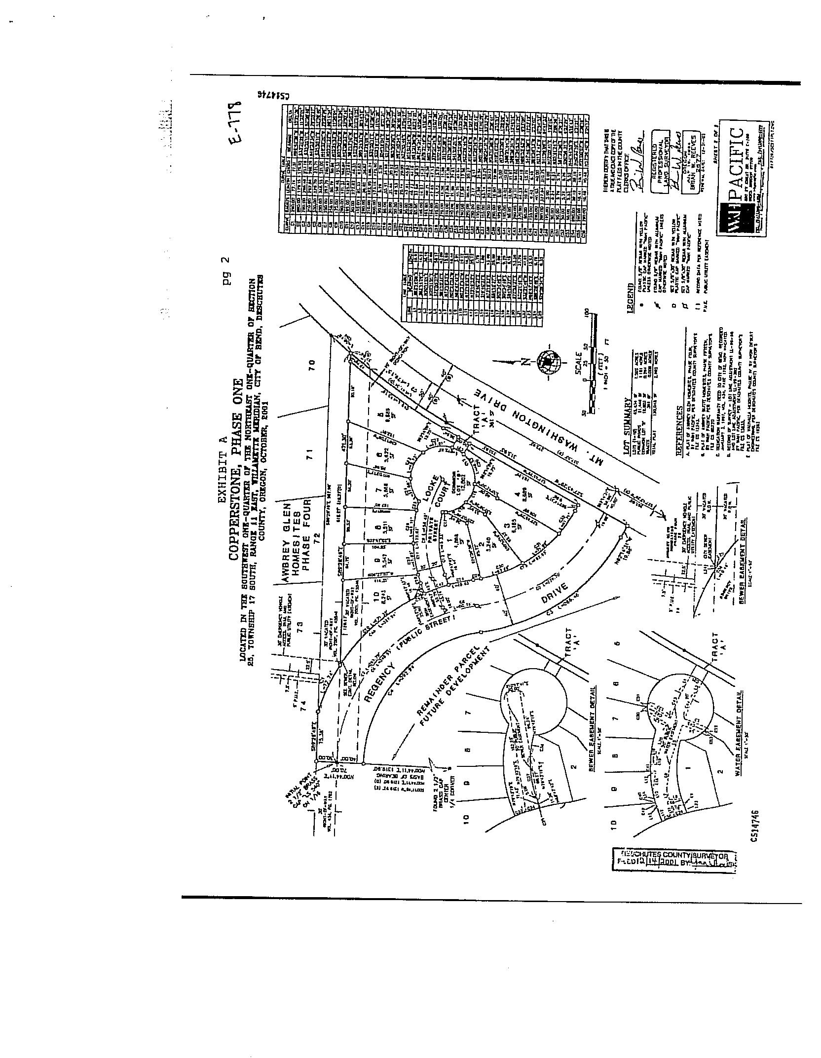
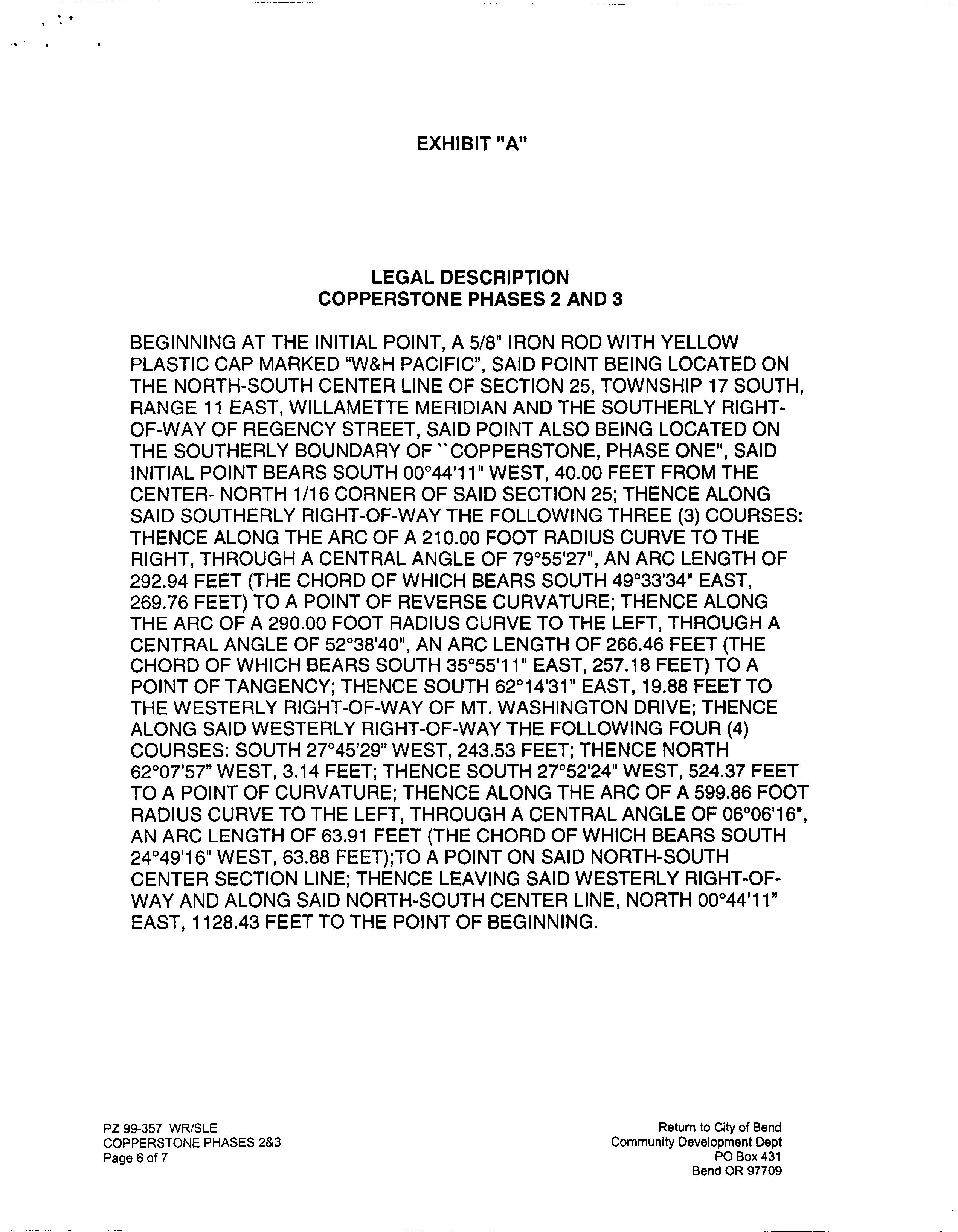
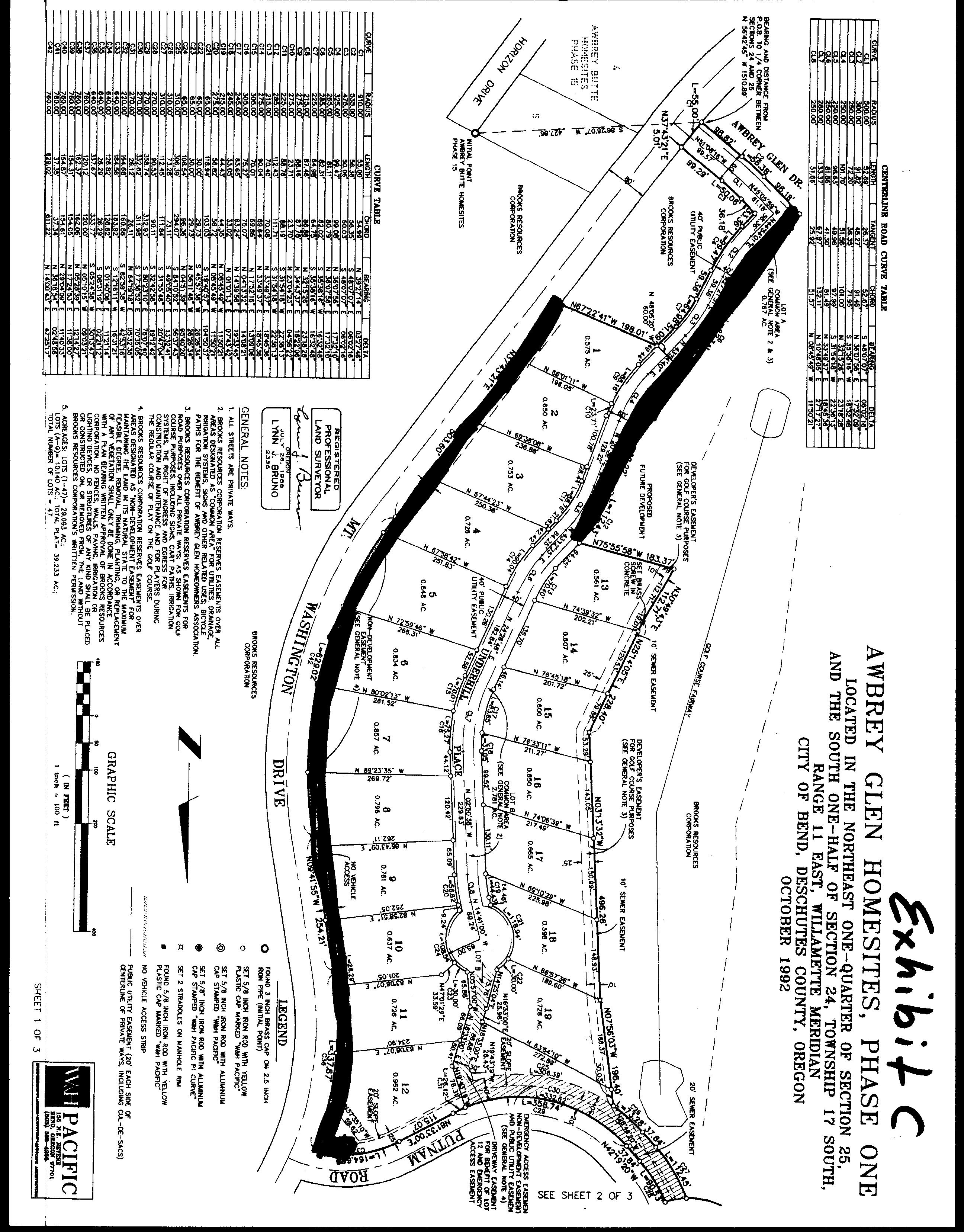
LOCATED IN THE SOUTHWEST QUARTER OF THE NORTHEAST QUARTER OF SECTION 25.
TOWNSHIP 17 SOUTH, RANGE 11 EAST, WILLAMETTE MERIDIAN, CITY OF BEND, DESCHUTES COUNTY, OREGON, NOVEMBER, 2002
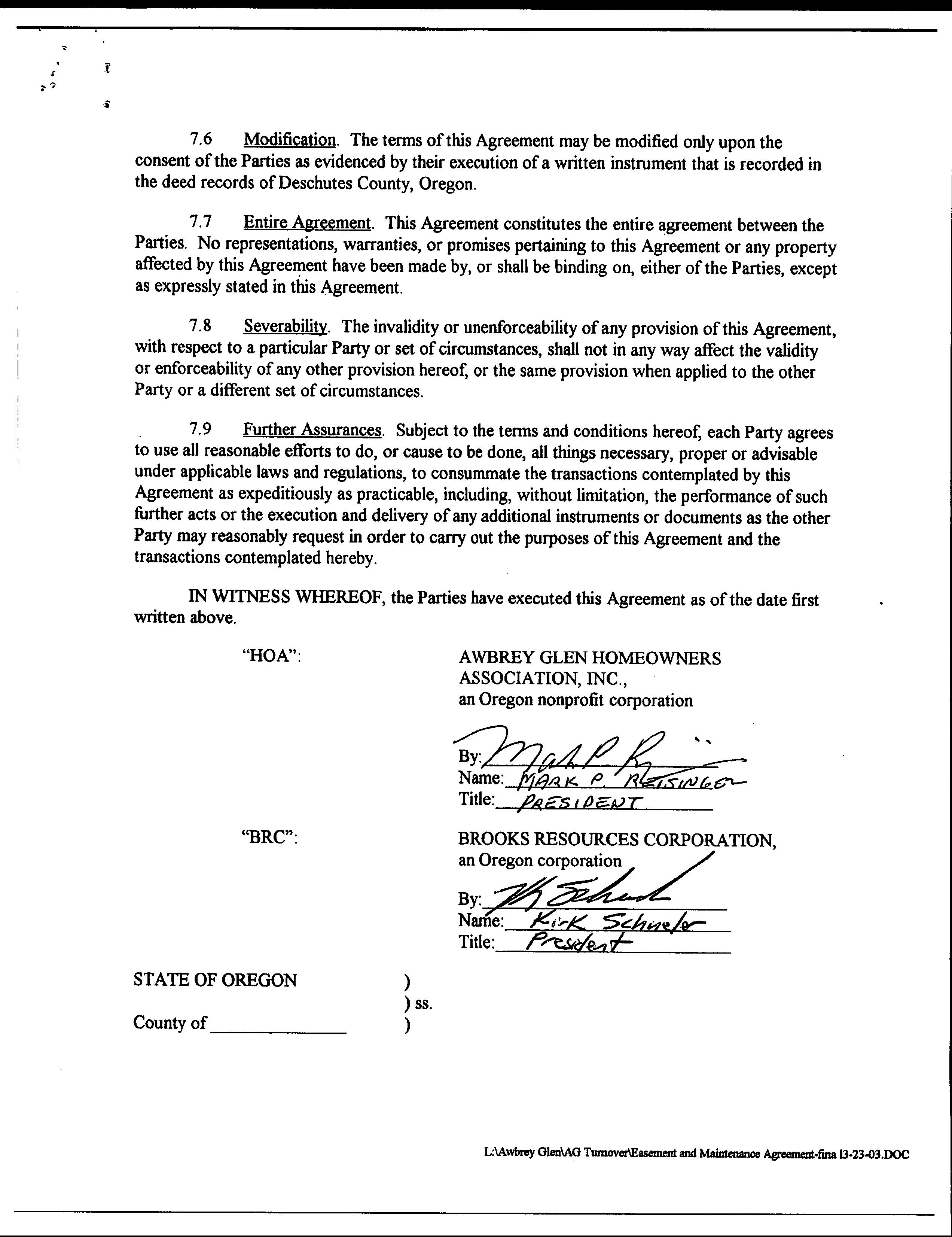
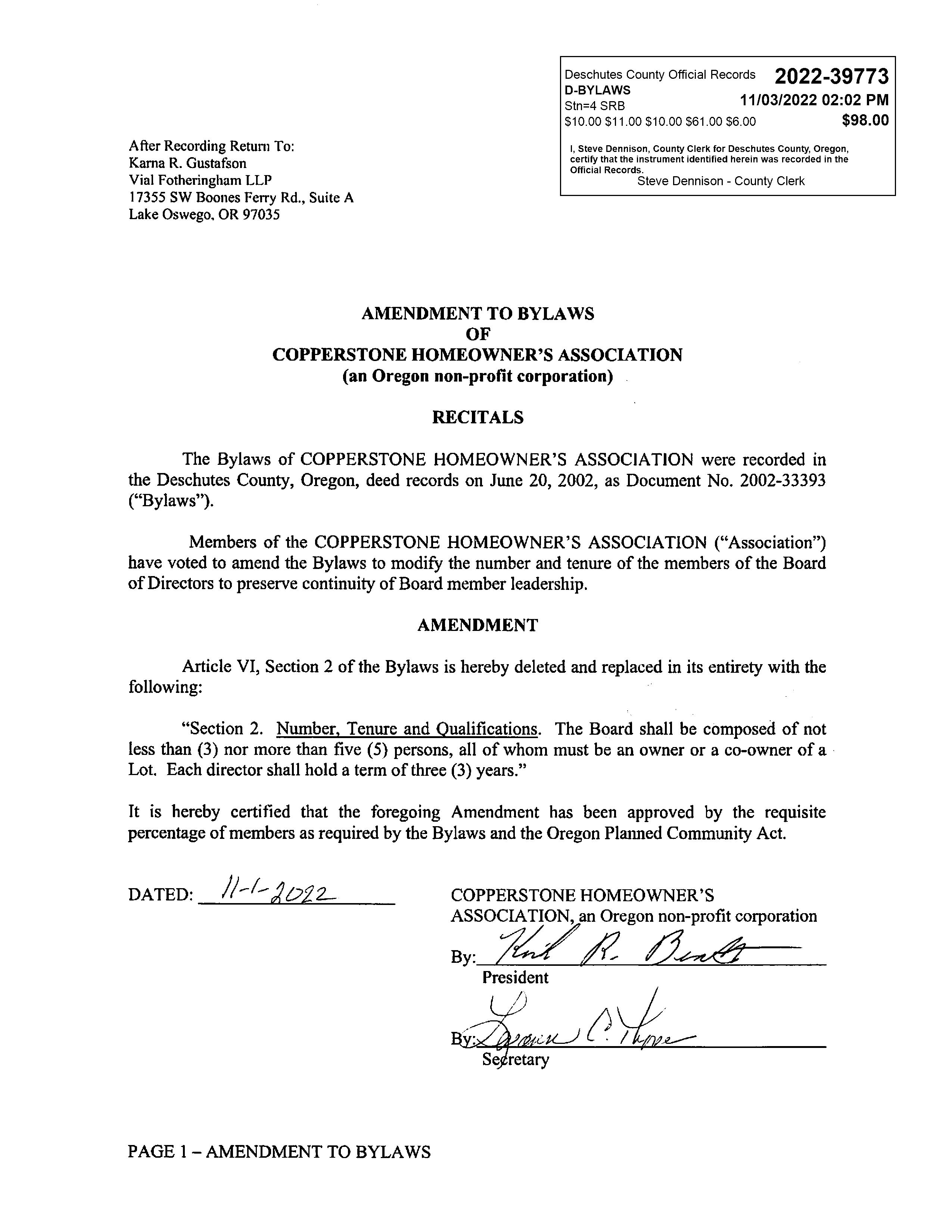
DECLARATION
KNOW ALL PERSONS BY LIMITED LIABILITY COMPANY. WERS OF THE LAND SHOWN ON CIATES LLC, AN OREGON SAID LAND TO BE SURVEYED AND PLATTED INTO PRIVATE LOTS. PUBLIC RIGHT OF WAY, PRIVATE STREETS (HAVRE COURT), CITY WATER EASEMENTS, CITY SEWER EASEMENTS, ACCESS EASEMENTS. DRAINAGE EASEMENTS, TRAIL EASEMENTS AND UTILITY EASEMENTS AS SHOWN ON THIS PLAT AND HEREBY DEDICATE TO THE USE OF THE PUBLIC FOREVER. SAID PUBLIC STREET RIGHT O WAY (10' ADDITIONAL TO MT. WASHINGTON DRIVE), UTILITY EASEMENTS AND TR MENT AND PUBLIC UTILITY EASEMENTS OVER COMMON LOT 'C', AND DEDICATE TO THE CITY OF BEND. TRACT 'A', THE CITY WATE CITY SEWER EASEMENT AS SHOWN ON THS PLAT, AND DO HEREBY OMMON LOT 'A' AND 'B' FOR COPPERSTONE ASSOCIATES AND DOES HEREBY SUBM AND RECORD THIS PLAT OF "COPPERSTONE, PHASES 2 & 3". HENCE
BY:
aER, PRESIDENT COPPERSTONE ASSOCIATES LC
ACKNOWLEDGEMENT
STATE OF OREGON COUNTY OF DESCHUTES
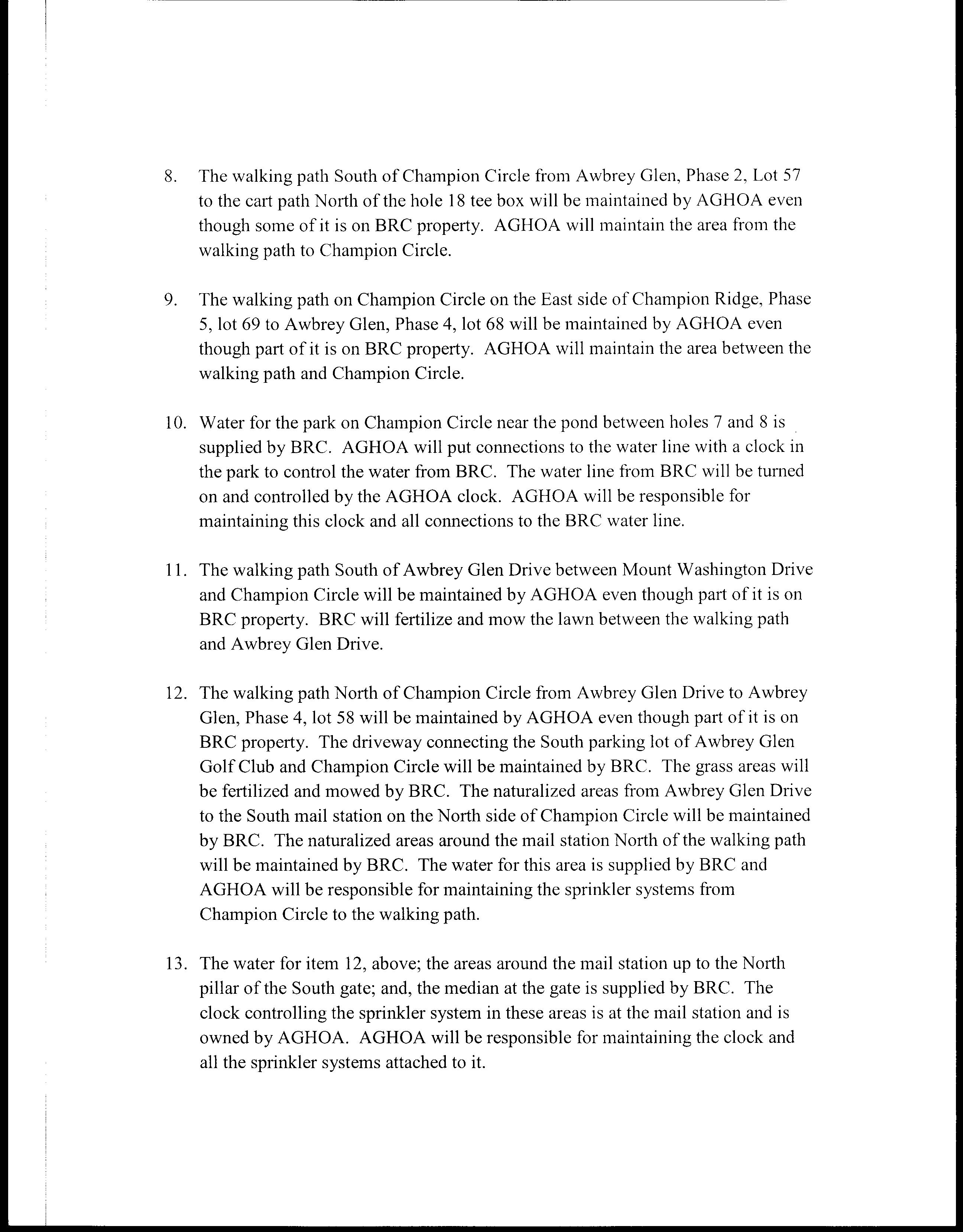
THIS INSTRUMENT WAS ACKNOWLEDGED BEFORE ME oNtebruany 14.200 2200 BY ON BEHALF OF THE CORPHE COPPER SSOCIATES LLC,
SURVEYORS CERTIFICATE
I. BRIAN W. REEVES, REGISTERED PROFESSIONAL LAND SURVE STATE OF OREGON, DO HEREBY CORRECTLY SURVEYED AND MARKED WITH PROPER MONUMENTS, THELAND SHOWN ON THIS P ERSTONE, PHASES 2 AND 3". TO THE NORMA LAND BEING MORE PARTICULARLY
BEGINNIN "W&c THE SOUT WES ST, AL ANGL LENG -TANGENCY AN TH CENTERLINE OF SE SAID WESTERLY RIGHT TH-SOUTH CENTERLINE, NORTH EAS THE Y OF REGENCY STREET INT O
NARRATIVE
PURPOSE PROPERTY DESCRIBED IN RARGA CORDED IN
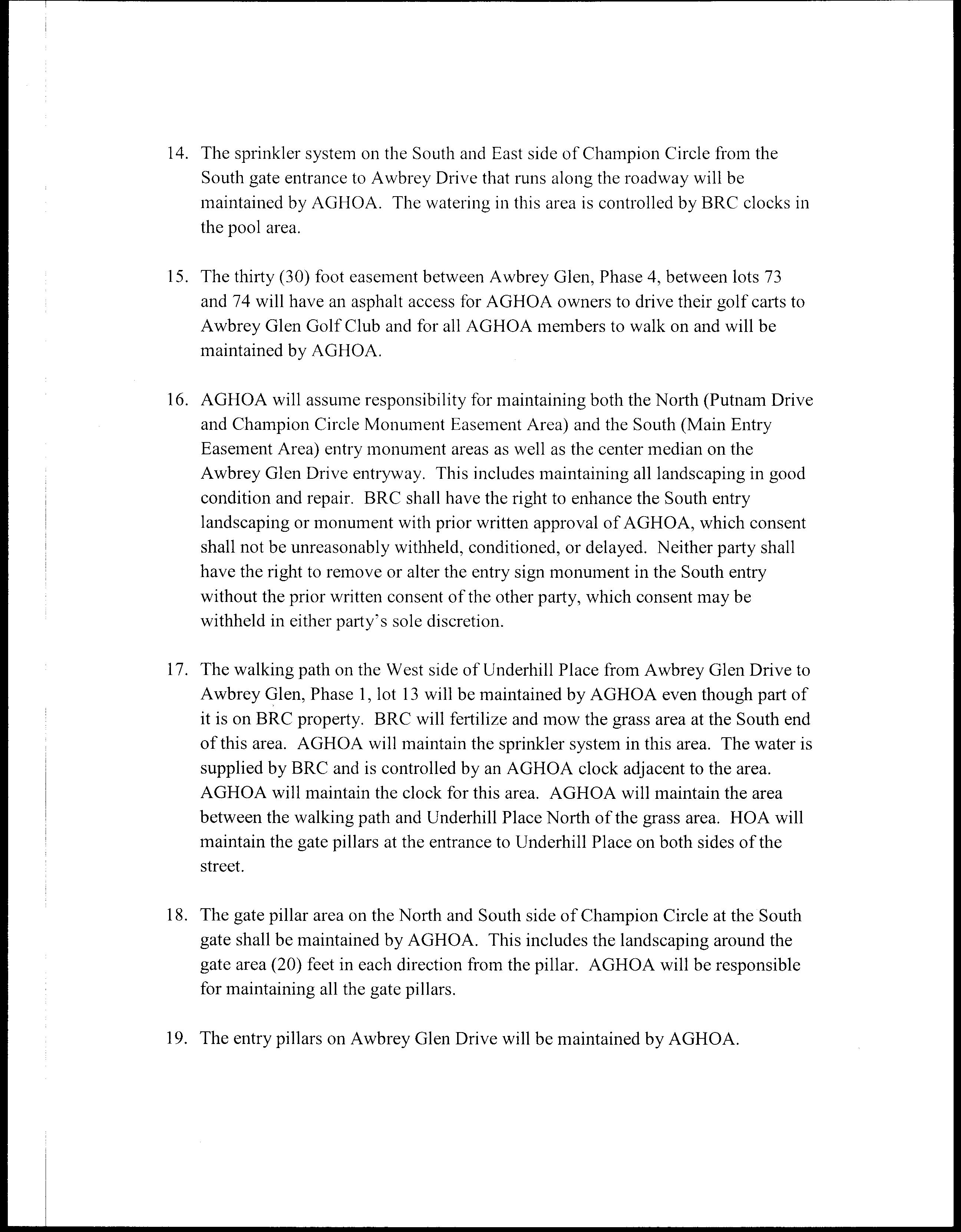
BOUNDARY OF THIS FOR LOT LINE ADJUSTMENT NO DESCHUTES COUNTY SURVE PHASE ONE, RECORDED CS14746.
BASIS
MONUMENTING THE CEN CORNER OF SECTON
NOTES
THE PARCELS IDENTIFIED WITH NTED TO BEND AN RUCT, INSTAL VER LINE AND WATER RELATE E SUR D WITHIN THE O PER THORIZED TO CONSTRUCT, ERECT OR INSTALL ANY STRUCTURES OR FACILITIES ON
DEDIKEDICATION OF PUBLIC RIGHT OF WAY: ADD G TO THE PUBLIC FOREVER SURY
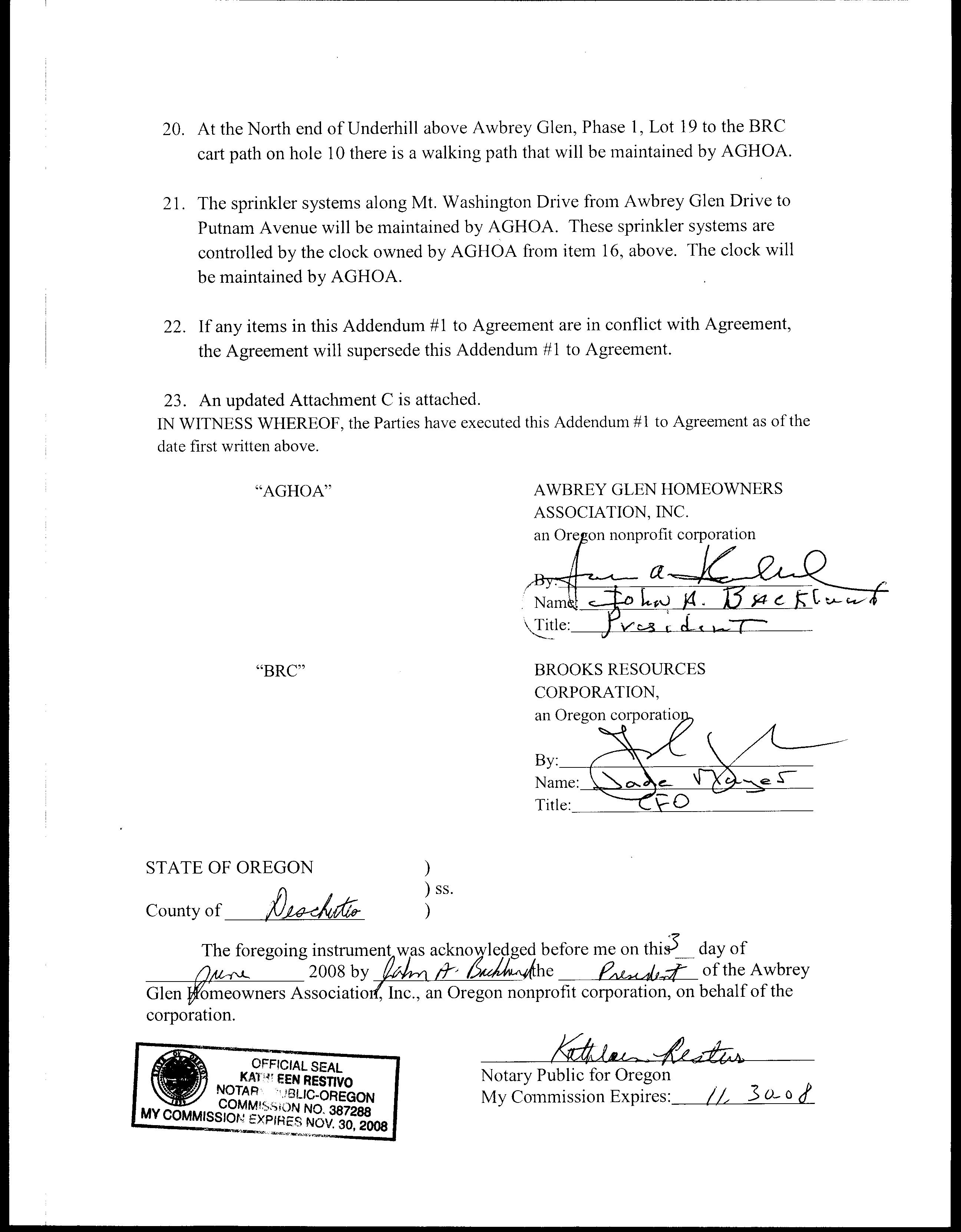
PRIVAT HAVRE COUR ASEMENTS OVER "COMMON 6. TRACT DEDICATED CITY OF BEND
ASSESSORS CERTIFICAT
1 HEREE THAT ALL ADVALOREM TAXES, SPECIAL ASSESSMENTS, FEES AND OTHER CHARGES,
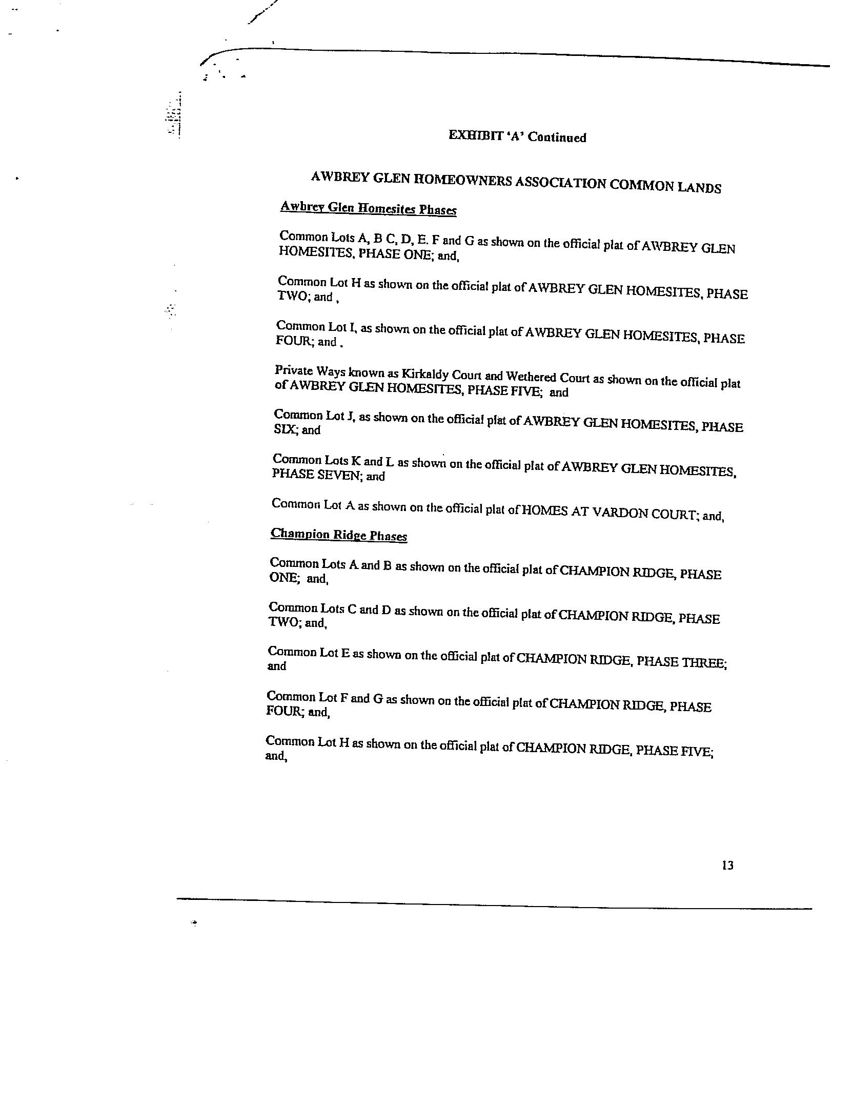
DECLARATION OF COVENANTS, CONDITIONS, AND RESTRICTIONS FOR AWBREY GLEN
THIS DECLARATION is made this 8th day of July, 1992, Brooks Resources Corpcration; an Oregon corporation ("Declarant").
0 BJECTIVES
by
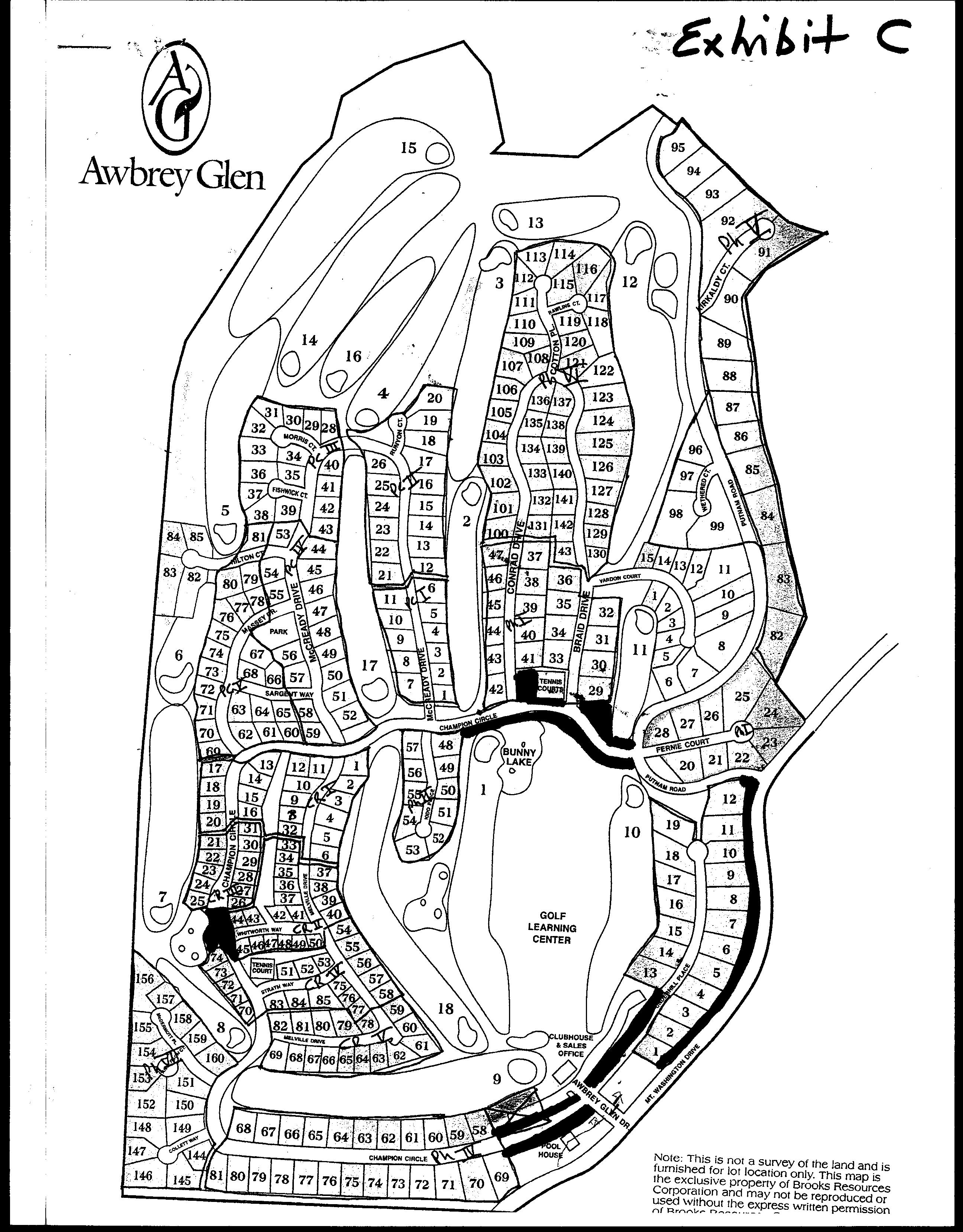
Declarant owns property located on Awbrey Butte in Deschutes County, Oregon. Declarant proposes to develop portions of this property as a planned development to be known as "Awbrey Glen." Declarant intends to create in Awbrey Glen a planned community whichwill provide an attractive place to live.
Declarant has recorded the platof Awbrey Glen Homesites, Phase One, in the plat records of Deschutes County, Oregon. Declarant desires to subject the property described in such plat to the covenants, conditions, restrictions, and charges set forth herein for the benefit of such property and its present and subsequent owners, and to establish such property as the first phase of the planned community to be known as "Awbrey Glen." Additional areas may be annexed to Awbrey Glen in accordance with the provisions set forth in this Declaration.
NOW, THEREFORE, Declarant hereby declares that the property covered in the plat of Awbrey Glen Homesites, Phase One more particularly described on Exhibit A attached hereto shall be held, sold, and conveyed subject to the following easements, covenants, conditions, restrictions, and charges, which shall run with such property and shall be binding upon all parties having or acquiring any right, title or interest in such property or any part thereof and shall inureto the benefit of each owner thereof.
ARTICLE 1
DEFINITIONS.
As used in this Declaration, the terms set forth below shall have the following meanings:
1.1 "Appeals Board" means a board formed pursuant to Section 7.13 to consider decisions of the Architectural Review Committee.
1.2 "Architectural Review Committee" means the Architectural Review Committee appointed pursuant to Article hereof. 7
1.3 "Association" means the nonprofit corporation to be formed to serve as the association of Owners (as hereinafter defined) as provided in Article 8 hereof, and its successors and assigns.
Alte tecording, return to RFN "1F OMPANY 1195 NW WL BUND
1.4 "Awbrey Glen" means the property designated in Section 2.1 of this Declaration andtany other property designated in any declaration annexing such property to Awbrey Glen in accordance with Section 2.2 of this Declaration, but excluding any property withdrawn from Awbrey Glen in accordance with Section 2.3 of this Declaration.
1.5 "Capital Improvement Assessments" means assessments to cover the cost of capital improvements made pursuant to Section 10.3.
1.6 "Common Areas" means the property referred to in paragraph 3.1 (b)
1.7 "Declarant Area" means, the land use classification described in paragraph 3.1(c).
1.8 "Declarant" means:Brooks Resources Corporation, an Oregon corporation, any person who succeeds to any special Declarant right and to whom allof the Declarant's ownership interest in Awbrey Glen is transferred, or any person, other than the Association, to whom the Declarant has transferred, for purposes of resale, all of Declarant's ownership interest in the planned community.
1.9 "Homesite" meansa Lot as defined Section 1.13.
1.10 in "Improvement" meansmevery temporary or permanent structure or improvement of any, kindyincluding but not limited to a house, fence, wall, driveway, swimming pool, storage shelter or other product of construction efforts on or in respect to any property within Awbrey Glen, including landscaping, and every alteration, painting or reconstruction thereof.
1.11 "Initial Development" means the property referred to in Section 2.1.
1.12 "Living Unit" means a building located or to be located upon a Homesite within Awbrey Glen and designated for separate residential occupancy (whether or not occupied) or ownership, but not including any building or portion of a building located on a Common Area.
1.13 "Lot" means a platted or.legally partitioned lot, within Awbrey Glen or any property so designated in any Supplemental Declaration annexing such property to Awbrey Glen, but not including any Common Area or any Declarant Area.
1.14 "Mortgage" means a montgáge, trust deed, or land sales contract; "mortgagee" means a mortgagee, beneficiary of a trust deed, or vendor under a land sales contract; and
017611-17/072442/XA(x1742
"mortgagor" means a mortgagörjgrantor of a trust deed, or vendee under a land sales contract
1.15 "Operatinq' Assessments" means the assessments to cover operating expenses referred to in Section 10.2.
1.16 "Owner" means the person or persons, including Declarant, owning any Homesite,including any vendee under a recorded land sales contract to whom possession has passed, but does not include a tenantor holderofa leasehold interest ora person holding only a security interest in a Homesite, including any vendor under a recorded land sales'contract who has given up possession. The rights, obligations, and other status of being an Owner commence upon acquisition' of the ownership of a Homesite and terminate upon disposition of such ownership, but termination of ownership shall not discharge an Owner from obligations incurred prior to termination
1.17 "Private Recreational Area" means any portion of the Common Area which is desighated as such by Declarant pursuant to Section 3.1(d).
1.18 "Private Way" means any area which is designated as such in the plat of the lInitial Development or any plat filed in connection with the annexation of additional real property, or in any Supplemental Declaration.s: to
1.19 "Reserve Account Assessments" means assessment cover the reserve fund, for replacements pursuant to Section 10.4.
1.20 "Supplemental Declaration" means an instrumen annexing additional real property to Awbrey Glen.
1.21 "This Declaration" means this Declaration of Covenants, Conditions,and Restrictions for Awbrey Glen and any and all declarations annexing property to Awbrey Glen.
ARTICLE 2
PROPERTY SUBJECT TO THIS DECLARATION
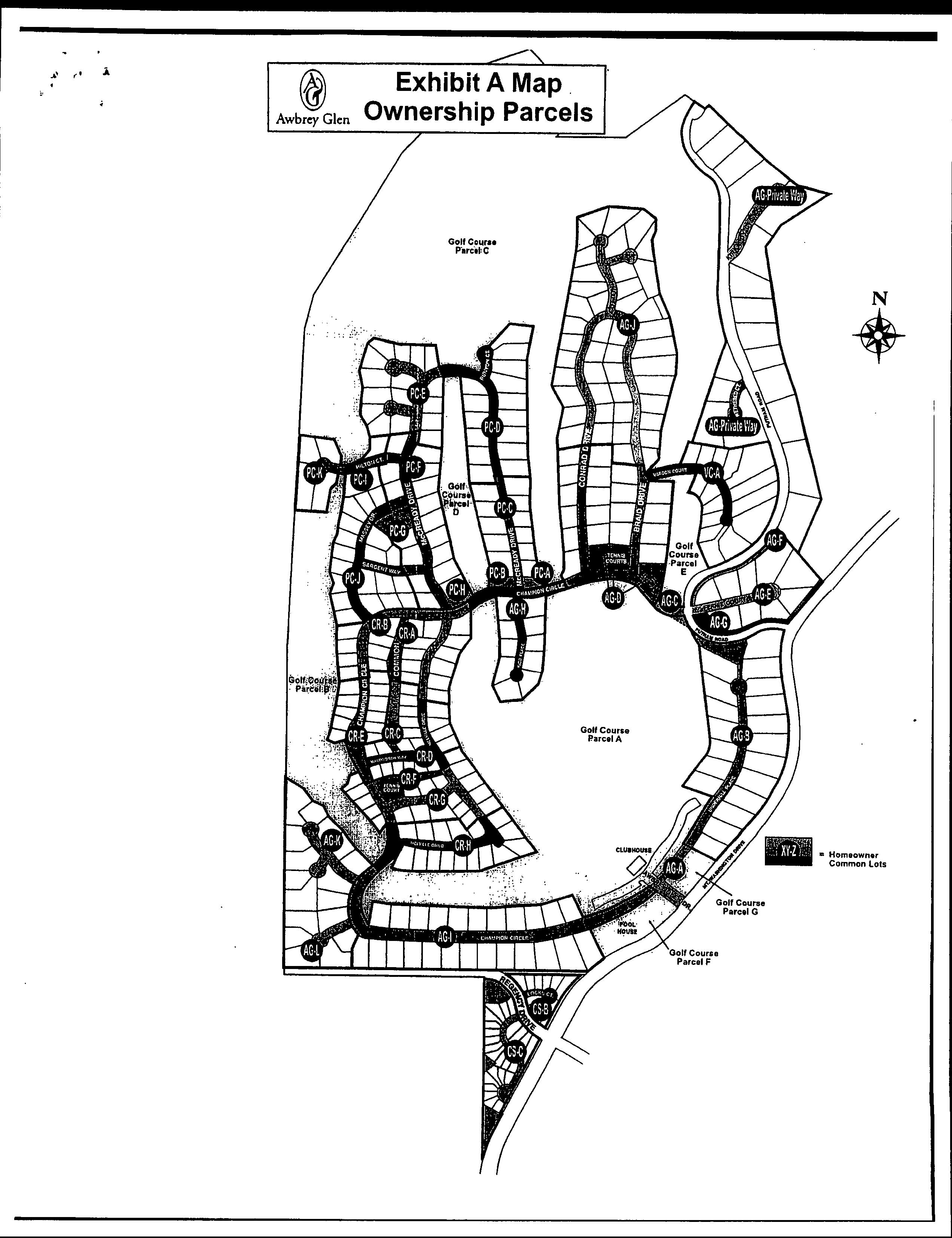
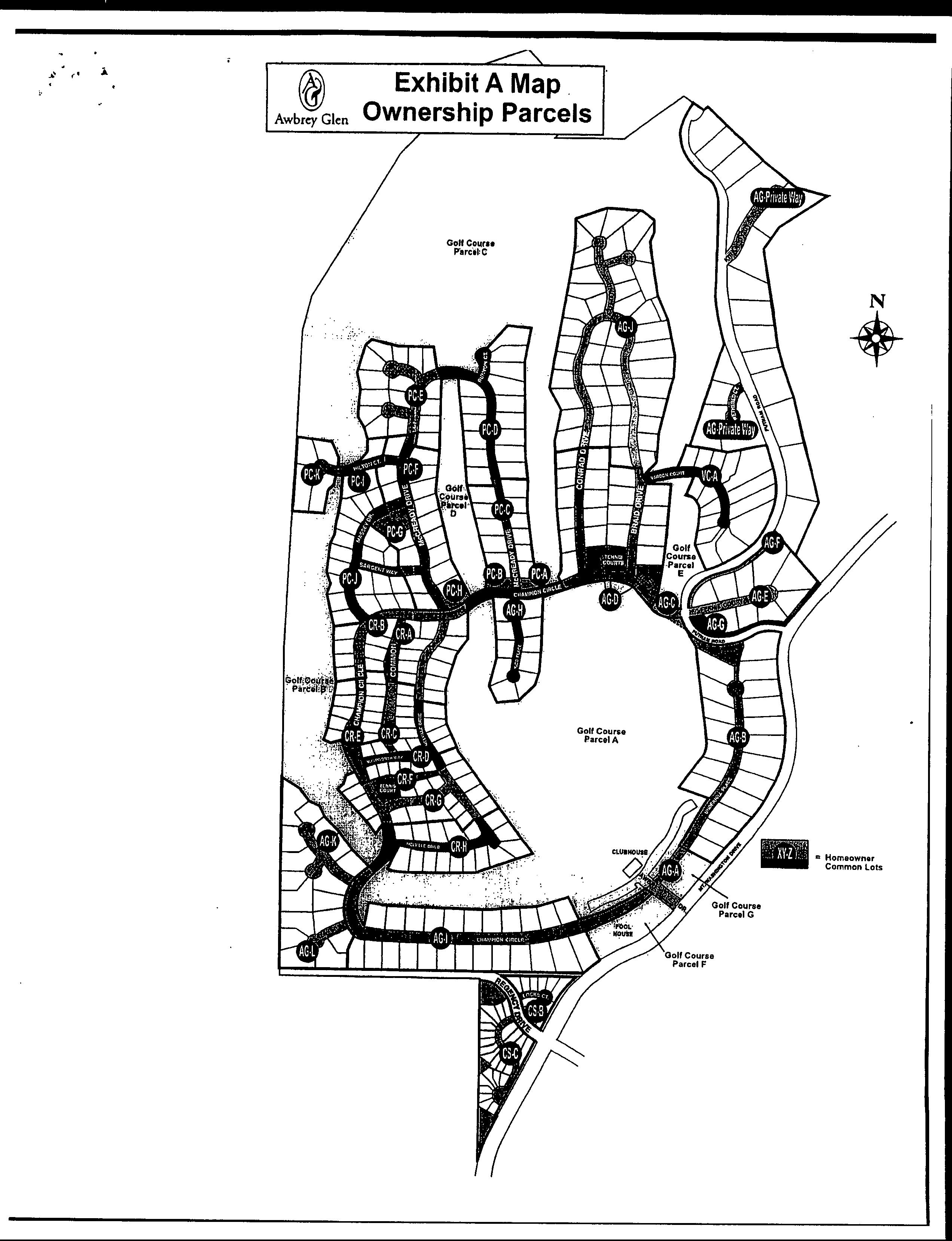
2.1 Initial Development. Declarant hereby declares that all of the real property described on Exhibit A attached hereto is owned and shall be owned, conveyed, hypothecated, encumbered, used, occupied, and improvedsubject to this Declaration. The Initial Development contains 48 Homesites and contemplates construction of one Living Unit on each Homesite.
2.2 Annexation of Additional Property. Declarant may from time to time and in its sole discretion annex to Awbrey Glen any adjacent real property now or hereafter acquired by it. The
61701117/072442/1A(0792
annexation of such adjacent real property shall be accomplished as follows:
(a) Supplemental Declàration. Declarant shall record a Supplemental Declaration which shall be executed by or bear the approval of Declarant and shall, among other things, describe the real property to be annexedi, establish any additional limitations, uses, restrictions, covenants, and conditions which are intended to be applicable to such property, and declare that such property is held and shall be held, conveyed, hypothecated, encumbered, used, occupied; and improved subject to this Declaration. Ehvra hd the 0e1
(b) Provisions of Supplemental Declaration. Notwithstanding any provision apparently to the contrary, a Supplemental Declaration with respect to any annexed property may:
(i) Establish such new land classifications and such limitations, uses, restrictions, covenants, and conditions with respect thereto as Declarant may deem to be appropriate for the development of the annexed property.
(ii) With respect to existing land classifications, establish additional or different limitations, uses, nestrictions, covenants, and conditions with respect thereto as Declarant may deem to be appropriate for the development of such annexed property.
(c) Effect of Annexation. The property included in any such annexation shall thereby become a part of Awbrey Gion and this Declaration, and the Declarant and the Association shall have and shall accept and exercise administration of this Declaration with respect to such property.
(d) No Limitation on Annexation. There is no limitation on the number of Homesites or LivingUnitswhich Declarant may create or annex to Awbrey Glen. There is no limitation on the right of Declarant to annex Common Areas.
(e) Voting Rights. Upon annexation, additional Homesites so annexed shall be entitled to voting rights as set forth in Section 8.3 below
(f) Adjustment of Association Expenses. The formula to be used for reallocating the common expenses if additional Homesites are annexed and the manner of reapportioning the common expenses if additional Homesites are annexed during a fiscal year are set forth in Section 10.5 below
/6/701.17/1792A072
2.3 Withdrawal of Property.Declarant may withdraw property from Awbrey Glen, including Common Area property, only byduly adopted amendment to/this Declaration, except that Declarant may withdraw all or'a portion of any property annexed pursuant to a declaration described in Section 2.2 above at any time prior to the sale of the first Homesite in the property annexed by such declaration.Suchiwithdrawal shall be by a declaration executed by Declarant and recorded in the official records of Deschutes County. If a portion of the Property is so withdrawn, all voting rights otherwise allocated to Homesites being withdrawn shall be eliminated, and the common expenses shall be reallocated as provided in Section 10.5 below. The right of Declarant to withdraw property hereunder shall not expire until the first Homesite in the last phase of Awbrey Glen been sold. has
2.4 Declarant Improvements.: Declarant agrees to build all improvements necessary for the Private Ways in Awbrey Glen. Declarant also agrees to build at least two tennis courts in Awbrey Glen. Declarant does: not agree to build any additional improvements but does not choose to limit Declarant's rights to addimprovements not described in this Declaration.
ARTICLE 3
LAND CLASSIFICATIONS
3.1 Initial Development. All land within the Initial Development is included in one of the following classifications:
(a) Homesites. Homesites shall consist of each Lot described on a subdivision plat or partition map with respect to Awbrey Glen or any alteration thereof as may be made by a valid Lot line adjustment. Homesites are intended for residential use.
(b( Common Areas: Common Areas shall consist of al1 areas designated as such or as "open space", "private way", or "bike paths" on the plat of the Initial Development or in any Supplemental Declaration or on the plat of any land annexed by Supplemental Declaration. Common Areas 'shall be subject to easements as provided in Section 4.3 (f).
(c) Declarant Areas. Declarant Areas shall consist of the areas designated as suchon the plat of the Initial Development or on the plat of any land annexed by Supplemental Declaration or in any Supplemental Declaration. Declarant Areas shall be owned by Declarant and may be used for a golf course, pro shop, restaurant, parking, sales or branch office, and other purposes compatible with the remainder of Awbrey Glen. Declarant Areas shall not be subject to any regular assessment, Capital Improvement Assessment, or other assessment pursuant to this Declaration.
61761137/172443XBA1792
Private
1984 (d) Recreational Areas. Declarant may designate certain portions of the Commön Areas as Private Recreational Areas. Private Recreational Areas shall be available for the use of Owners of less than all of the Homesites. The location of each iPrivate Recreational Area and the Homesites entitled to usé each Private Recreational Area shall be designated either on the plat covéring the Private Recreational Area or in a sepárate instrument recorded by Declarant in the official records of Deschutes County, Oregon. The cost of maintenance and improvement of each Private Recreational Area shall be borne equallyby the Owners of Homesites entitled to use such Private Recreational Areas.
3.2 Additional Land Classifications. Additional land classifications and uses may hereafter be established in any declaration annexing property ito Awbrey Glen as provided in Section 2.2 above.
3.3 Conversion of Homesites to.Common Areas. Declarant may elect to build common facilities on one or more Homesites and designate such Homesites as Common Areas by a declaration recorded in the official records of Deschutes County. Such declaration shall be executed'by: Declarant, as owner of the Homesites.
3.4 Consolidation of Homesites. The Owner of two adjoining Homesites or portions of adjoining Homesites, with the approval of the Architectural Review Committee, may elect to consolidate such Homesites into one Homesite. The Architectural Review Committee may impose reasonable conditions or restrictions on the granting of its approval of a Homesite consolidation, including, but not limited to maintenance or landscaping requirements and limitations on use. The consolidation shall be effective upon the recording in the deed records of Deschutes County of a declaration of the Owner stating that the two Homesites are consolidated. The declaration shall include a written consent to the consolidation executed on behalf of the Architectural Review Committee by at least' one member thereof and a description of any restrictions and conditions imposed as a condition of such consent. Thereafter, and except if otherwise provided by the Architectural Review Committee as a condition to its consent, the consolidated Homesites shall constitute one Homesite for all purposes of this Declaration, including voting rights and assessments. No Living Unit may be placed upon the remainder of a Homesite, a portion of which was consolidated with another Homesite but which remainder has not been consolidated with another Homesite, unless the area of such remainder constitutes at least 90 percent of the oniginal area of the Homesite. Areas which have once been consolidated may not be partitioned at any time in the future. ARTICLE 4
4.1
PROPERTY RIGHTS IN COMMON AREAS
Owner's Easements of Enjoyment. Subject to provisions of this Declaration every Owner and such Owner's invitees shall have a' right andeasement of enjoyment in and to the Common Areas including, without limitation, Private Ways and bike paths but excluding Private Recreational Areas.
4.2 Title to Common Areas. Fee title to the Common Areas shall be conveyed by Declaränt to, and must be accepted by, the Association free and clear of liens and encumbrances other than those created pursuant to this Declaration.
4.3 Extent of ownersRidhts. The rights and easements of enjoyment in the Common Areas created hereby shall be subject to the following'and all other provisions of this Declaration:
(a) Association's and Owners' Easements. Declarant grants to the Associationifor: thecbenefit of the Association and all Owners of Homesites within Awbrey Glen the following easements over, under, and uponothe' Common Areas:
(i) An easement ifor installation and maintenance of power, gas, electric,water; and other utility and communication lin smandservices installed by Declarant or with the approvalofnthe Board of Directors of the Association and any, such easement shown on any plat of property within Awbrey Glena
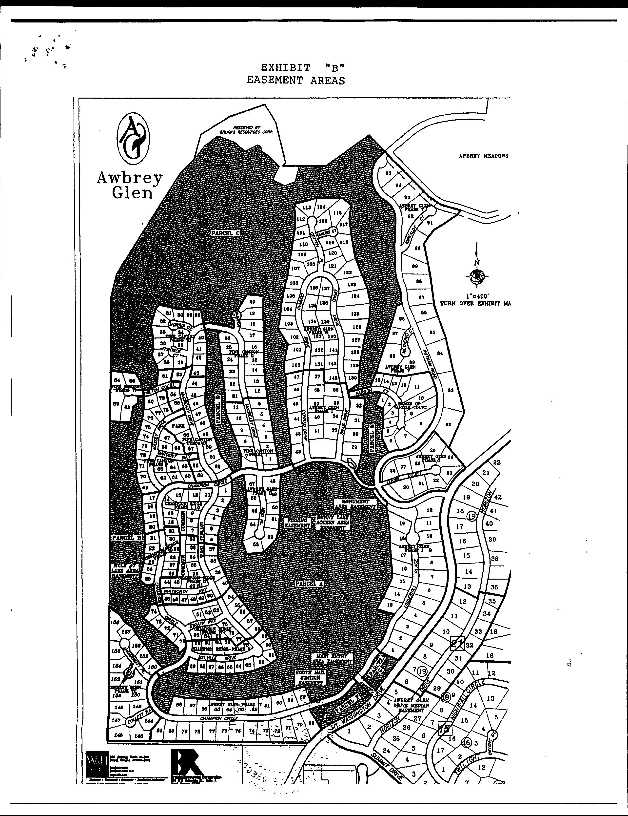
(ii) An easementy for construction, maintenance, repair, and use of ithe Common Areas and common facilities thereon, including, but not limited to, walkways, bike paths, fences, landscaping, irrigation systems, entry way structures, decorative ornamentation, and signs,and-for any purposes and uses adopted by the Association for the benefit of the Association and the Owners..
(iii) An easement for the purpose of making repairs to any existing structure on the Common Areas.
(b) Declarant's Easements. So long as Declarant owns any Homesite, and in addition,to any other easements to which Declarant may be entitled Declarant reserves an easement over, under, and across the Common. Areaswin order to carry out development, construction, and sales activities necessary or convenient for the development ofAwbrey Glen and the sale of Homesites and Living Units and for such other purposes as may be necessary or convenient for the development of Awbrey Glen and the sale of Homesites and Living Units and for such other purposes as may be necessary or convenient for discharging
6172-17/4172492/XA742
Declarant's obligations or for exercising any of Declarant's rights hereunder. As long as Declarant owns any Declarant Areas within or adjacent torAwbrey Glen or has any maintenance obligations with respect to Awbrey Glen, Developer shall have an easement across the Common Areas as required to maintain and improve the Declarant Areasand to carry out its maintenance responsibilities with respect to Awbrey Glen. Declarant shall have an easement varyingin width designated as "Developer's Easement" on the plat of the Ihitial Development and on plats covering any land annexed by 'Supplemental Declaration for golf course purposes, including the right in ingress and egress for construction, maintenance, and for players during the regular course of play on the golf course.
(c) Utility Easements. Declarant or the Association may (and, to the extentorequired by law, shall) grant or assign easements to municipalities;communication companies, or other utilities over Common Areas performing utility services, and the Association may grant free access#thereon to police, fire, and other public officials and to employees of utilitycompanies and communications companies serving Awbrey Glen.
(d)Use of the CommonAreas. Except as otherwise provided in this Declaration, including without limitation the provisions in Section 4.3 (f), the Common Areas shall be reserved for the use and enjoyment of all owners and no private use may be made of the Common Areas.Nothing herein shall prevent the placing of a sign or signs upon the Common Areas for the purpose of identifying Awbrey: Glen or any subdivisiontherein, indicating golf cart path directions, or identifying trails or other items of interest, provided such signs are approved by the Architectural Review Committee. The Board of Directors of the Association shall have authority to abate any trespass or encroachment upon the Common Area at any time, by any reasonable means and with or without having to bring legal proceedings.
(e) Alienation of the Common Areas. The Association may not by act or omission seek to abandon, partition, subdivide, encumber, cause the Common Area to be subject to any security interest, sell, or transfer the Common Areas owned directly or indirectly by the Association for the benefit of the Homesites unless the holders of at least 80 percent of the Class A voting rights (as described ih Section 8.3 (b) below) and the Class B member (as defined in Section 8.3 (b) below), if any, have given their prior written approval. This provision shall not apply to the easements described in this Section 4.3. A sale, transfer, or encumbrance of the Common Area or any portion of the Common Area in accordance with thisSection 4.3 (e) may provide that the Common Area so conveyed shall be released from any restriction imposed on such Common Area by this Declaration. No sale, transfer, or encumbrance, may, however, deprive any Homesite of 1761 17/1172492/XIA(1792
such Homesites right of accesstor support without the written consent of the Owner of the Homesite
(f) Restrictiohs on Use of Common Areas. Use of the common Areas by the Owners shall be subject to the provisions of this Declaration and to'thei following:
(i) The right ofthe Association to suspend such use rights of an Ownereto the extent provided in Article 11 below.
(ii) The right of the Association to adopt, amend, and repeal rules and regulations in accordance with this Declaration and the Bylaws of the Association, including, without limitation, the right to require reservations for use of the Common Area or Common Area facilities and the right to impose reasonable fees in connection with such use.
(iii) The rightof Declarant to construct and maintain golf cart paths and related signage on the Common Area for use by invitees of Declarant and lusers of facilities on Declarant Areas.
Declarant hereby reservesufor each Owner an easement for driveway and underground utility purposes across any Common Area lying between such Owner's Homesite and the Private Way providing access to such Homesite. The width of such driveway easement shall not exceed 20 feet. Declarant also reserves a nonexclusive easement over the Common Area forsigns, public utilities operation, maintenance, ingress and legress of its golf course, well, pipelines irrigation systems, and related uses on property owned by Declarant. of
(g) Private Ways. Each Owner shall have a nonexclusive easement for use of Private Ways for the purposes walking thereon or traveling thereon by appropriate means. Each Owner may permit his guests and invitees to use the Private Ways for such purposes. The easement provided for herein shall be appurtenant to and assignable with the Homesite with respect to which it is granted, but shall not be otherwise assignable. The use of Private Ways shall be subject to rules and regulations adopted by the Board of Directors of the Association. The Board of Directors shall have the right to erect gates across Private Ways and bike paths and to regulate access through such gates. Declarant, its employees and invitees of its pro shop, learning center, and maintenance facilities, shall at all times have reasonable access over and across Private Ways. The Board of Directors shall be responsible for providing reasonably convenient means by which Declarant, its employees and invitees shall have access through any gates. Gates across Private Ways shall be placed in such a manner as to minimize passage by
61761.171172492INBA
Declarant, its employeeswand invitees. The Board of Directors, in its discretion, mayidedicate Private Ways to the public. The Board of Directors shal1 grant freedaccess on Private Ways to police, fire, and other public officials, to employees of utility companies serving Awbrey Glen, and to such others to whom the Board believes access should begiven for the benefit of Owners. Declarant may use Private Ways for its own purposes and for the purpose of location of utilities! There shall be no implied dedication of Private Ways
4.4 Delegätion of Use. Any Owner may delegate, in accordance with the Bylawsof the Association, such Owner's right of enjoyment of the CommonAreas to the members of such Owner's family or tenants who reside on the Homesite.
ARTICLE 5
PROPERTY RIGHTS IN HOMESITES
5.1 Use and Occupancy. Except as otherwise expressly provided in this Declarationrin the plat in which a Homesite was platted or partitionedmorrin any declaration annexing such Homesite to Awbrey Glen, the Owher of a Homesite in Awbrey Glen shall be entitled to theexclusiveiuse and benefit of such Homesite.
5.2 Easements Reserved. In addition to any easements shown on the recordedi plats, Declarant hereby reserves the following easements for the benefit of Declarant and the Association:
(a) Adjacent Common Area or Declarant Area. The Owner of any Homesite which blends together visually withany Common Area or Declarant Area shall permit the Association or Declarant, as the case may be, to enter upon such Homesite to perform the maintenance of such Common Area or Declarant Area.
(b) Right of Entry. Declarant, the Architectural Review Committee, and any representative of the Association authorized by it may at any reasonable time, and from time to time at reasonable intervals; enter upon any Homesite for the purpose of determining whether or not the use of and/or Improvements on such Homesite are then in compliance with this Declaration. No such entry shall be deemed to constitute a trespass or otherwise createfany right of action in the Owner such Homesite. of
(c) Utility Easements. Easements for installation and maintenance of utilities are reserved over the rear and side five (5) feet of each Homesite. Such easements are also reserved over the front and on other portions of certain Homesites, as shown on the recorded plat. Within the easements, no structure,
1761-17/0072492/XHA(x1742
212- 1989
planting or other material shall be placed or permitted to remain which may damage or inter'fere with' the installation or maintenance of utilities. The easement area of each Homesite and all Improvements in it shall be maintained continuously by the Owner of the Homesite, except fori those improvements for which a public authority or utility company is responsible.
5.3 Restriction on Transfer. There shall be no inter vivos transfer, either directly or indirectly, of any interest in a Homesite or a Living Unit which would result in any person owning, either directly or indirectly through a corporation or a partnership, less than a twenty percent (20%) interest in such Homesite or Living Unit without the prior written consent of Declarant.
ARTICLE G
RESTRICTIONS ON USE OF HOMESITES
6.1 Occupancy. No Owner shall occupy, use, or permi his Homesite, or any part thereof) to be used for any purpose other than a private residence for the Owner, his family or his guests, except that each Owner shall be permitted to rent the Unit for periods of no shorter duration than 30 days when he is not in occupancy. Nothing in this section shall be deemed to prohibit (a) activities relating to the sale of Living Units, (b) the right of Declarant or any contractor or homebuilder to construct Living Units on any Homesite, to store construction materials and eguipment on Homesites in the normal course of construction. Declarantimayuse any! Living Unit as a sales office or model home for purposes of sales in Awbrey Glen. or
6.2 Improvements. Each Homesite shall be maintained in a clean and attractive condition;in good repair, and in such a fashion as not to create a fire hazard
6.3 Appearance. All garbage, trash, cuttings, refuse, garbage, and refuse containers, clothes drying apparatus and other service facilities located on each Homesite shall be screened from view in a mánner approved by Declarant.
6.4 Construction and Alteration. Nothing shall be altered or constructed in or removedfrom or placed on a Homesi except with the prior written consent of Declarant.
6.5 Offensive or Commercial Activity. No offensive or commercial activity shall be carrled on, nor shall anything done on any Homesite which may be'or become an annoyance or nuisance to the other Owners.
6.6 Signs. No signs shall be erected or maintained on any Residential Homesite except signs which are approved as be
61761-17/172492/XA
appearance and location by Declaranti The restrictions contained this paragraph shall not: apply to in
(a) Political "SiansThe temporary placement of "political" signs on any Homesite by the Owner thereof; h dn
(b) Declarant'sSales Office and Model Home Signs. The placement by the Declarant or Declarant's agent of one or more signs identifying the name of the Declarant and/or the location of a sales oificelor módel home; or
(c) For Sale Signs The temporary placement of not more than one "For Sale" sin on any Homesite meeting the guidelines of Declarant or the Architectural Review Committee and facing the Private Way providing access to such Homesite.
6.7 Exterior Lighting'or Noise Making Device. No exterior lighting or noise making device shall be placed on a Homesite, or any portion thereof, without the Declarant's prior written consent.
6.8 Antennas and Satellite Dishes. Exterior satellite receiver, transmission dishes, exterior antennas, or other sending or receiving devices shall not be permitted to be placed upon any Homesite exceptas approved by Declarant.
6.9 Limitation ont Transfer. No Owner shall transfer, either by conveyance, contractcof sale, or lease, any interestin his Homesite which would resultiinownership of such Homesite being held by more than ten persons elar1
6.10 Prohibited Structures. No house trailer, mobile home, manufactured home assembled off site, tent, shack, barn, or other similar outbuilding or structure, whether permanent or temporary, shall be erected or placed on any Homesite.
6.11 Single Family Residences. No more than one single family residence shall be erected or placed on any Homesite. !
6.12 Utilities. No above-ground utilities, pipes, wires shall be used to connect improvements with supplying facilities.
6.13 View. The heightof vegetation and trees on a Homesite shall not materially restrict the view of other Owners Declarant shall be the sole judge of the suitability of such heights. If the Declarant determines there is such restriction to the view of the other Owners written notice shall be delivered to the offending Owner. If after 30 days the vegetation or trees are not removed or reduced in height as directed by Declarant, Declarant shall enter the offending
Homesite, complete the removal ör redcharging the Owner of the Homesite the reasonable costsfor the work done. This section is not to be read as justification to create views not present when the Homesite was originally purchased.
6.14 Parking. A minimum of two outdoor parking places in addition to covered parking must be provided for each Homesite and must meet the standards setby thel Declarant. No house trailer, travel trailer, boat trailercamper, incapacitated motor vehicle, snowmobile, motor home or off-road vehicle shall be parked or stored on any Homesite or dommon Area except as provided in the Association's rules and regulations or the architectural guidelines. uited
6.15 Control of Pets. No pets or domestic animals shall be permitted to run loose'or unattended. Owners of pets shall beresponsible for compliance with all leash laws and other laws related to the control of pets.Nokanimals shall be kept or raised on any Homesite except household pets and domestic animals not used for any commercial purpose. osted
6.16 Firearms or Other Weapons. No firearms, air pistols, archery, sling shots,wfireworks,or any other weapons or projectiles shall be used or discharged within Awbrey Glen except in such areas as may be desinated iin writing by the Board of Directors.
6.17 Motor Vehicles. Except for golf carts and carts specifically approved by the Board of Directors, no motorized vehicle shall be operated anywhere exceptlupon a surfaced roadway, nor shall any motor vehicle be parked in otherthan a designated parking area. Except for golf carts or other carts specifically approved by the Board of Directors and except for construction equipment not required to be licensed, no unlicensed vehicles shall be operated within Awbrey Glen.
ARTICLE '7
ARCHITECTURAL REVIEW
7.1 Approval Requiréd No Improvement, as defined in Section 1.10 above, shall be erected;placed, altered, maintained, or permitted to remain on any land subject to this Declaration until final plans and specifications have been submitted to and approved in writing by Declarant. All approvals shall be in conformance with the building'areà established on each Homesite unless otherwise approved by the Declarant.
7.2 Procedure. Any Owner proposing to construct any Improvements within Awbrey Glen (including any exterior alteration, addition, destruction, or modification to any such Improvements) shall follow the procedures and shall be subject to : 13
61760-37/0072492/XIA(x1792
the approvals required by this-Article 7. Failure to follow such procedures or obtain such approvals as required by this Article 7 shall be deemed a breach of this Declaration.
7.3 Required:Documents. Any Owner proposing to utilize, improve, or develop real property within the Awbrey Glen shall submit the followingitems for review:
(a) A site plan showing the location, size, configuration, and layout of any building, structure, or Improvement (or, where appl'icable any alteration, addition, modification, or destruction thereto), including appurtenant facilities for parking, storage, fences, and vehicular and pedestrian traffic and ciroulation.
(b) Architectural plan's and drawings showing the nature, style, and dimensionsof any building, structure, fence, wall, barrier, or deck(or; where applicable, any alteration, addition, modification,or destruction thereof), including the exterior material types, colors, and appearance. The scale of plans shall be 1 inch 201feet or larger. slami
(c) A landscape plan showing the nature, type size, location, and layoutof all landscaping, vegetation ground cover, landscape and site lighting, walks, major existing vegetation and irrigation systems proposed to be planted or installed (or, where applicable, removed or destroyed)
7.4 Review.hAll plans and drawings identified in Section 7.3 above shallibe submitted to Declarant for review prior to the performance ofany proposed work. Such plans and drawings shall be accompaniedby a check payable to Declarant in an amount to be determined by Declarant from time to time No plans shall be reviewed until the architectural review fee is paid in full and all items specified in this section are submitted. Within 30 days following receipt of such plans and drawings, and the full amount of the architectural review fee, Declarant shall review the plans and shall inform the Owner in writing whether the plans conform to the development concept for Awbrey Glen. In the event the Owner is not notified as to the conformity of the plans within the 30-day review period, the plans are conclusively presumed to be approved as submitted. In the event any of the plans do not conform to the Awbrey Glen development concept, the Owner shall resubmit those nonconforming portions of the plans for' review in accordance with the procedures outlined in Section 7.3 above and this paragraph. No work may be performed relating to any Improvement unless and until all aspects of all plans required under Section 7.3 above and this paragraph. No work may be performed relating to any improvement unless and until all aspects of all plans required under Section 7.3 above have been approved by Declarant. Any site plans, construction plans, or similar plans and drawings
212-1993
submitted to the city of Bend i'n connection with the construction of any Improvement in the Awbrey Glen must bear the prior written approval of Declarant. 18901
7.5 Architectural Guidelines: The development concept for Awbrey Glen shallbe determined by Declarant in accordance with applicable statutes, ordinances, regulations, zoning, and other governmental land use controls. Architectural guidelines setting forth various aspects of the development concept, in addition to this Declaration; may be published from time to time by Declarant, but Declarant"shall not be required to do so. Declarant shall have the right to alter, rescind, or amend any publishedguidelines without prior notice to any party; provided, however, that once approval has been given pursuant to Section 7.4 above, work may proceedin accordance with the approved plans and drawings, notwithstanding any changes in the development concept. All such guidelines shall be in general conformity with this Declaration.
7.6 Inspection. All work related to any building, structure, or Improvement or any landscaping, vegetation, ground cover, or other Improvements within Awbrey Glen shall be peformed in strict conformity with the plans and drawings aporored under Section 7.4 above. Declarant shall have the right to inspect any such work to determine its: conformity with the approved plans and drawings and rreserves the right to ordera stop to all work if, in good faith, it believes that any such work is nonconforming. In therevent that it is determined in good faith by Declarant that certain work is nonconforming, a stop work notice may be issued, without necessity of court order, which shall require the Owner to correct all nonconforming work specified in the notice before the remainder of the proposed work may be completed. Continued work without correction of any such nonconforming items shall be deemed a breach of this Declaration. Neither Declarant nor any officer, director, employee, agent, or servant of Declarant shall be responsible for any damages, loss, delay, cost, or legal expense occasioned through a stop work notice given in good faith, even if 'it is ultimately determined that such work was in conformity with the approved plans and drawings.
7.7 Waiver. Any condition or provision of Sections 7.2 through 7.6 above may be waived in Declarant in its exclusive discretion. Any waiver shall be in general conformity with the development concept and development standards for Awbrey Glen. Any such waiver shall not' be deemed a general waiver of any aspect of the development concept or the required procedures and approvals specified under Sections 7.2 through 7.6. The granting of a waiver as to one Owner shall not automatically entitle any other Owner to the waiver of the same or similar conditions or provisions. No waiver shall be valid unless it is in writing, signed by an authorized representative of Declarant.
17617/072492/XTIAIX1792
212- 1994 and delivered by certified mail to the party claiming the benefit of such waiver.
7.8 Architectural Review Committee. At such time as Declarant shall no longer desire to exercise its rights of approval under Article 5, Article 6, and Article 7, such approval rights shall be exercised by an Architectural Review Committee. The termination of Declarant's approval "rights shall be evidenced by the recording of an instrument in the official records of Deschutes County, Oregon.The Board of Directors shall have responsibility for appointment and removal of members of the Architectural Review Committee. The Architectural Review Committee shall consist of as many persons, but not less than three, as the Board of Directors may from time to time appoint. If the Board of Directors fails to appoint the members of the Architectural Review Committee, the Board of Directors shall itself serve as the Architectural Review Committee.
7.9 Majority Action. Except as otherwise provided herein, a majority of the members of the ArchitecturalReview Committee shall have the power to act on behalf of the Architectural ReviewCommittee, without the necessity of a meeting and without the necessity of consulting or notifying the remaining members of the Architeotural Review Committee. The Architectural Review Committee may render its decision only by written instrument setting forth the action taken by the members consenting thereto.
7.10 Liability. The scope of Declarant's or the Architectural Review Committee's review is not intended to include any review or analysis, of structural, geophysical, engineering, building or zoning code compliance, or other similar considerations. Neither Declarant nor the Architectural Review Committee nor any member thereof shall be liable to any Owner, occupant, builder, or developer for any damage, loss or prejudice suffered or claimed on account of any action or failure to act of the Architectural Review Committee or a member thereof, provided only that Declarant or the Architectural Review Committee has, or the member has, in accordance with the actual knowledge possessed by Declarant or the Architectural Review Committee or by such member, acted in good faith
7.11 Effective Period of Consent. The Declarant's and the Architectural Review Committee's consent to any proposed Improvement shall automatically be revoked one year after issuance unless construction of "the Improvement has been commenced or the Owner has applied for and received an extension of time from the party granting consent.
7.12 Construction by Declarant. Improvements constructed by Declarant on any property owned by Declarant, are not subject to the requirements of this Article 7.
7.13 Appeals Board. Any person adversely affected by a decision of the Architectural Review Committee, which decision is made after the turnover meeting described in Section 8.6, may appeal such decision to an Appeals Board: The Appeals Board shall be appointed by the President of the Association and shal1 include at least one member of the! Architectural Review Committee. The decision of the Appeal's Boaru shall be final. Any appeal of a decision of the Architectural Review Committee must be in writing and must be delivered tothe President of the Association within ten days after theldecision to which the appeal relates. The Board of Directors may impose a reasonable fee to cover the cost of any appea
ARTICLE 8her
ASSOCIATION
Declarant shall organize an association of all of the Owners within Awbrey Glen. Such Association, its successors, and assigns, shall be organized tunder thename "Awbrey Glen Homeowners Association, Inc!orsuch isimilar name as Declarant shall designate, and shall have such property, powers, and obligations as are set forthin this Declaration for the benefit of Awbrey Glen and all Ownersiofproperty located therein.
8.1 Organization. Declarant shall, before the first Homesite is conveyed to an Owner prganize the Association as a nonprofit mutual benefit corponation under the Oregon Nonprofit Corporation Act.
A ab
8.2 Membership. Every Ownerhof one or more Homesites within Awbrey Glen shall, immediately upon creation of the Association and thereafter during the entire period of such Owner's ownership of one or more Homesites within Awbrey Glen, be a member of the Association. Such membership shall commence, exist, and continue simply by virtue of such ownership, shali expire automatically upon termination of such ownership, and need not be confirmed or evidenced by any certificate or acceptance of membership.
8.3 Voting Rights. Voting rights within the Association shall be allocated as follows:
(a) Homesites. except as provided in Section 8.3 (b) with respect to Class B members Homesites shall be allocated one vote per Homesite.
(b) Classes of Voting Membership. The Association shall have two classes of voting membership:
Class A. Class A members shall be all Owners with the exception of the Declarant (except that beginning on the date on 177072492/N131792
212- 1996 which the Class B membèrship is converted to Class A membership, and thereafter, Class A members shall be all Owners including the Declarant). Class A member's shall be entitled to voting rights for each Homesite owned computed in accordance with Section 8.3(a) above. When more than one person holds an interest in any Homesite, all such persons shall be members. The vote for such Homesite shall be' exercised as they among themselves determine, but in no event shall more than one vote be cast with respect te any. Homesite.
Class B. The Class B member shall be Declarant and shall be entitled to nine times the voting rights computed under Section 8.3(a) for each Homesite owned by Declarant. The class B membership shall cease land be converted to class A membership on the happening of either of the following events, whichever occurs earlier:
(i) When seventy-five percent (75%) of the Homesites in the final phase of development of Awbrey Glen have been soldandconveyed to Owners other than Declarant; or
(ii) At such earlier time as Declarant may elect in writing to terminate Class B membership.
8.4 Powers and-Obligations. The Association shall have, exercise, and perform all of the following powers, duties, and obligations:
(a) Declaration: The powens, duties, and obligations granted to the Association by this Declaration.
(b) Statutory Powers. The powers, duties, and obligations of a mutual benefit nonprofit corporation pursuant to the Oregon Nonprofit Corporation Act and of a homeowners association of a planned community pursuant to the Oregon Planned Community Act, as either or both may be amended from time to time.
(c) General. Any additional or different powers, duties, and obligations necessary or desirable for the purpose of carrying out the functions of the Association pursuant to this Declaration or otherwise promoting the general benefit of the Owners within Awbrey Glen
The powers and obligations of the Association may from time to time be amended, repealed, enlarged or restricted by changes in this Declaration made in accordance with the provisionsherein, accompanied by changes in the Articles of Incorporation or Bylaws of the Association made in accordance with such instruments and with the Oregon Nonprofit Corporation Act 41761-37/1172442/X11A00742
Brarsabo
8.5 Liability. Neither the Association nor any officer or member of its Board of Directors shall be liable to any Owner for any damage, loss or prejudice suffered or claimed on account of any action or failure to act by the Association, any of its officers or any member of its Board of Directors, provided only that the officer or Board member has acted in good faith in acdordance with the actual knowledge possessed by him.
8.6 Interim Board; Turnover Meeting. Declarant shal1 have the right to appoint an interim board of three directors or more, who shall serve as the Board of Directors of the Associationfuntil replaced by Declarant or their successors have been elected by the Owners at the turnover meeting described in this Section. Declarant shall'call a meeting by giving notice to each owner as provided in the Bylaws of the Association for the purpose of turning over administrativeresponsibility for Awbrey Glen to the Association notlater than one hundred twenty (120) days after Homesites representing 'seventy-five percent (75%) of the votes in all phases of Awbrey: Glen computed in accordance with Section 8.3 (a) sabovë have been sold and conveyed to Owners other than DeclarantIf Declarant does not call a meeting required by this Section within the required time, the Transitional Advisory Committee described in Section 8.7 below or any Owner may call a meeting and give 'notice as required in this Section. At the turnover meeting ithe interim directors shall resign and their successors shall be elected by the Owners and Declarant as provided in this Declaration and the Bylaws of the Association.
8.7 Transitional Advisory Committee. Declarant or Owners shall form a transitional advisorycommittee (the "Transitional Advisory Committee") to provide for the transition from administrative responsibility by Declarant of Awbrey Glen to administrative responsibilityby the Association. Not later than the sixtieth (60th) day after the Declarant has conveyed to Owners other than Declarant Homesites representing fifty percent (50%) of the votes of all phases in Awbrey Glen computed in accordance with Section 8.3(a) above, Declarant shall call meeting of Owners for the purpose of selecting the Transitional Advisory Committee. The Transitional Advisory Committee shall consist of three or more members. The Owners, other than Declarant, shall select two or more members. Declarant may select no more than one member. The Transitional Advisory Committee shall have reasonable access to all information and documents which Declarant isreguired to turn over to the Association under ORS 94.616.
(a) Declarant Failure to Call Meeting. An Owner may call a meeting of Owners to select the Transitional Advisory Committee if the Declarant fails to do so as provided above.
6176-374072492/X11AIX742
(b) Owners' Failure to Select Members.
1998 Notwithstanding the foregoing, if the Owners do not select members for the Transitional Advisory Committee as described above, Declarant shall have no further obligation to form the Transitional Advisory Committee
(c) Turnover Meeting. The requirement for formation of a Transitional Advisory Committee shall not apply once the turnovermeeting specified in Section 8.6 above has been held.
8.8 Declarant Control After Turnover. After the turnover meeting described in Section 8.6 above, Declarant shall continue to have the voting rights described in Section 8.3(b) above. In addition, a majority of the Board of Directors of the Association shall be elected by Declarant, as class B member, with the balance of the Board of Directors elected by the class A members. After termination of class B membership, all directors shall bo elected by the Class A members.
8.9 Subassociations.: Nothing in this Declaration shall be construed as pröhibiting the formation of subassociations within Awbrey Gleni
8.10 Association Rules and Requlations. The Association from time to time may adopt, modify, or revoke such rules and regulations governing thel conduct of persons and the operation and use of Homesites andi the Common Areas as it may deem necessary or appropriate in order to assure the peaceful and orderly use and enjoyment of the property within Awbrey Glen. A copy of the rules and regulations, upon adoption, and a copy of each amendment, modification or revocation thereof, shall be deliveredby the Association Board of Directors promptly to each Owner and shall be binding upon all Owners and Occupants of all Homesites upon the date of delivery. The method ofadoptionof such rules shall be as provided, in the Bylaws of the Association.
ARTICLE
MAINTENANCE; UTILITIES, AND SERVICES
9.1 Maintenance and Lighting of Common Areas. The Association shall perform all maintenance upon, and where the Association deems appropriate provide exterior lighting for, the Common Areas and all improvements situated thereon, including without limitation, gatesand recreational facilities, provided that any such lighting shall require prior written consent of Declarant The Association shallalso perform necessary maintenance on all Private Recreational Areas, the cost of which shall be allocated pursuant to paragraph 3.1(d).
9.2 Maintenanceof Utilities. The Association shall perform or contract to perform maintenance of all private utilities within Common Areas, such as sanitary sewer service lines, domestic water!ervice liñes, storm water detention facilities, and storm drainage lines, except to the extent such maintenance is performed by theiutilities furnishing such services.
9.3 Road Maintenance!! It is anticipated that a road running generally in a north-south direction on the west side of AwbreyGlen and a road ón the south boundary of Awbrey Glen will be dedicated to the public Notwithstanding the fact that such roads will serve property not included inAwbrey Glen, the Association shall be résponsible for maintenance of such north- south road until such time as it is accepted for maintenance by the city of Bend or other entityn
ARTICLE 10
ASSESSMENTS
10.1 AnnualOperatingBudgets. The Association Board of Directors shall from:time to time and at least annually prepare an operating budget for! the Association, taking into account the current costs of maintenance and services and future needs of the Associationganytprevious overassessment and any common profitsof theiAssociationThebudget shall provide for such reserve or contingency funds as the Board deems necessary or desirable or as may be requiredby law. The method of adoption of thebudget shall be as provided in the Bylaws.
10.2 Operating Assessments. All Homesites shall be assessed equally for operating costs. The amount of the assessment per Homesite shall be determined by dividing the annual budget by the total number of Homesites.
10.3 Capital Improvement Assessments. The Association may purchase, construct or otherwise acquire additional equipment, facilities or other: capital improvements for the general use and benefitof all the members of the Association, and forthat purpose may impose a special assessment to be called a "Capital ImprovementAssessment." Any such assessment shall be assessed to the Homesites within Awbrey Glen on the same formula as set forth in Section 102. No new Capital Improvement Assessment may be imposed under this section which, for any one purchase, construction or other acquisition, or group of related purchases, constructions or other acquisitions, in theaggregate exceeds $300 per Homesite, unless approved by the vote or written consent of the Class Bamember, if any, and by not less than sixty percent (60%) of the votes of the Class A members who are voting in person, by absentee ballot or by proxy at a no
6176437/1172492/XIA0742
212 2000
duly called for the purpose of approving the Capital Improvement Assessment.e
10.4 ReserverAccount for Replacing Common Property. Declarant shallestablish äireserve account which shall be called the "Common Property Reserve Account," and whichwill be kept separate and apart from a11other funds of the Association. Except as provided in Section 10.4(b) below, the Common Property Reserve Account shall be used exclusively for replacement of items of common property which will normally require replacement, in whole or in part in more than three and less than thirty years and not for reqular or periodic maintenance expenses.
rarty aS
(a) Reserve Account Assessments. Not less often than annually, the Association shall inventory all items of common property which wil1: normally requirereplacement, in whole or in part, in more than three and" less than thirty years, and shall estimate the remaining life of each item of common property and the current replacement costof each of such items. The Association may identify items for which a reserve account assessment is requiredrasithose items which are insurable by a common carrier ofall-purpose risk insurance. For the purpose of funding the Common Property Reserve Account, the Association shall impose an àssessment to be called the "Common Property Reserve Account Assessment"against each Homesite on the same formula as set forthin Section 10.2. The total Common Property Reserve Account Assessment (shall take into account the current replacement cost of reach item of common property which has an estimated life ofagreater than three but less than thirty years and the estimated remaining life for such items of common property. Declarant shall not be required to pay any assessment under this Section 10.4 assessed to a Homesite owned by Declarant until such date as the Homesite is conveyed by the Declarant to an unaffiliated party in an arms-length transaction.
(b) Loan From Common Property Reserve Account. After the turnover meeting described in Section 8.6 above, theBoard of Directors of the Association may borrow funds from the Common Property Reserve Account to meet high seasonal demands on the Association's regular operating fund or to meet other temporary expenses. Funds borrowed to meet high seasonal demands or temporary expenses junder this paragraph must be repaid from special or operating assessment within six months of the date such funds are borrowed.
(c) Increase, Reduction, or Elimination of common Property Reserve Account Assessments. At any time after the second year after the turnover meetingdescribed in Section 8.6 above, future assessments for the Common Property Reserve Account may be increased, reduced oreliminated by the vote of Owners of Homesites representing seventy-five percent (75%) of the votes computed in accordance with Section 8.3 above.
10.5 Reallocation Uponl: Annexation or Withdrawal of Property. When additional property jor phases are annexed to or withdrawn from Awbrey Glen, the Association shall, within 60 days of the annexation, recompute the budget in accordance with Section 10.1 based upon the additional Homesites and Common Areas and recomputeassessments foreach Homesite based upon the formula set forth in Section 102 Newlyannexed Homesites shall be subject to assessment from the time of annexation of such Homesites to Awbrey Glen, in accordance with the provisions of Section 10.2. The Association shall send notice of the assessment to the Owners of newly annexed Homesites not later than 60 days after the annexation or with the'next occurring annual assessment whichever is sooner.Assessments shall be due and payable on or before a date set forthin the notice which shall be not less than 30 days fromthe date that notice is mailed or at such other time ortimes set in accordance with this Declaration or the Bylaws as the Association may specify in the notice. To the extent that any adjustmentresults in a credit for an Owner, suchcredit shall be applied towards the next occurring payment or payments onathe annual assessment.
irn Alpo
10.6 Payment of Assessments The Association shall, not less than annually, provide notice to the Owner of each Homesite of the amount of the assessmentsfor such Homesite. Assessments shall be due and payablehon oribefore a date set forth in the notice which shallobelnotaless than 30 days from the date the notice is mailed or at such other time or times set in accordance with this Declaration or the.Bylaws as the Association may specify in the notice. The Board shalt have the right to give discounts for advance payment, ofassessments.
10.7 Creation of Lien; and Personal Obligation of Assessments. Declarant, for each Homesite owned by it within Awbrey Glen does hereby covenant, and each Owner of any Homesite by acceptance of a conveyance thereof, whether or not so expressed in any such conveyanceshall be deemed to covenant to pay to the Association all assessments or other charges as may be fixed, established, and collected from time to time in the manner provided in this Declaration or the Association Bylaws. Such assessments and charges, together with any interest, expenses or attorney fees imposed pursuant to Sectiont11.6, shall be a charge on the land and a continuing lien upon the Homesite againstwhich each such assessment or charge is made. Such assessments, charges, and other costs shall also, bej the personal obligation of the person who was the Owner of such Homesite at the time when the assessment or charge fell due. Such, liens and personal obligations shall be enforced in the manner set forth in Article 11 below.
10.8 Declarant's Maintenance Payments. After conversion of Declarant's Class B membership, Declarant shall pay 3 percent of the cost of maintenance of Private Ways to
61766-37/72492/X11AX792
compensate for the use of Private Ways bylits employees and invitees of Declarant's pro shop, Tearhing center, and maintenance facilities.
ARTICLE 11
ENFORCEMENT
11.1 Use of Common Areas In the event any Owner or the invitee of any Owner shall violate any provision of this Declaration, the Bylaws ofthe Association or "any rules or regulations adopted by the Association governing the use of Homesites or Common Areas then the Association, acting through its Board of Directors, may notify the Owner in writing that the violations exist and that such Owner is responsible for them, and may, after reasonable notice and opportunity to be heard, do any or all of the following: (a) suspend theowner's voting rights and right to use the Common Areas for the period that the violations remain unabated or for any perlod not to exceed sixty (60) days for any infraction of its rules and regulations, (b) bring suit or action aainst suchowner to enforce this Declaration, or (c) impose finescasprovided in Section 11.7. Nothing in this section, however shall give the Association the right to deprive any Owner of access to and from such Owner's Homesite. et prvid
11.2 Nonqualifying Improvements and Violation of General Protective Covenants. In the event any Owner constructs or permits to be constructed on such Owner's' Homesite an Improvement contrary to the provisions of this Declaration, or causes or permits any Improvement,activity, condition or nuisance contrary to the provisions of this Declaration to remain uncorrected or unabated on such Owner's Homesite, then the Association acting through its Board of Directors may notify the Owner in writing of any such specific violations of this Declaration and may require the Owner to remedy or abate the same in order to bring the Owner's Homesite, the Improvements thereon, and the Owner's use thereof, into conformance with this Declaration. If the Owner is unable, unwilling, or refuses to comply with the Association's specific directives or remedy or abatement, or the Owner and the Association cannot agree to a mutually acceptable solution within the framework and intent of this Declaration, after notice and opportunity to be heard and within sixty (60) days of written notice to the Owner, then the Association acting through its Board of Directors, shall have, in addition to anylother rights or remedies provided in this Declaration, at law or in equity; the right to do any or all of the following:
(a) Remove Cause of Violation. Enter onto the offending Homesite, without being subject to any trespass, conversion or any other claim for damages, and remove the cause
6176-17/4172442/XIA(X1742
of such violation, or alter, repair or change the item which is in violation of the Declaration in such a manner as to make it conform thereto, in which case the Association may assess such Owner for the entire cost of the work done.
(b) Suit or Action. Bring suit or action against the Owner on behalf of the Association and'other Owners to enforce this Declaration.
(C) Section 11.7.
Fines Impose one'or more fines as provided in
11.3 Default in Payment of Assessments; Enforcement of Lien. If an assessment, fine, or other charge levied under this Declaration is not pald within thirty (30) days of its due date, such assessment or charge shall become delinquent and shall bear interest from the due date until paid at the rate set forth below and, in addition, the Association may dexercise any or all of the following remedies:
(a) Suspension of Rights: Acceleration. The Association may suspend such Owner's voting rights and right to use the Common Areas until such amounts, plus other charges under this Declaration, are paid in full and may declare all remaining periodic installments of any annual assessment or any other amounts owed by such Owner to the Association immediately due and payable. In no event however, shallthe Association deprive any Owner of access to and from such Ownerds Homesite.
(b) Lien The Association shall have a lien against each Homesite for any assessment levied against the Homesite and any fines or other charges imposed underthis Declaration or the Bylaws against the Owher of the Homesite from the date on which the assessment, fine pr charge is due. The provisions regarding the attachment, notice, recordation, and,duration of liens established on real property under ORS 87.352 to 87.386 shall apply to the Association's lien. The lien shall be foreclosed in accordance with the provisions regarding the foreclosure of liens under ORS Chapter 88. The Association, through its duly authorized agents, may bid on the Homesite at such foreclosure sale, and may acquireand hold, lease, mortgage, and convey the Homesite. If any assessment is payable in installments, the full amount of the assessment is a lien from the date the first installment of the assessment becomes due.
(c) Suit or Action. The Association may bring an action to recover a moneyjudgment for unpaid assessments and charges under this Declaration without foreclosing or waiving the lien described in paragraph 11.3(b) above. Recovery on any such action, however, shall operate to satisfy the lien, or the portion thereof, for Which recovery is made.
170-37172492/XBV0079
212- 2004
(d) Other Remedies The Association shall have any other remedy available to it' by law orin equity.
11.4 Notification of First Mortgagee. The Board of Directors may notify any first mortgagee of any Homesite of any default in performance of this Declaration by the Homesite Owner which is not cured within sixty (60) days.
11.5 Subordination:of Dien to First Mortqages. The lien of the assessments or charges provided for in this Declaration shall be subordinate to the lien of any first mortgage on such Homesite which was made in good faith and for value and which was recorded: prior to the recordation of the notice of lien. Sale or transferbof anylHomesite shall not affect the assessment lien, provided however, that if a first mortgagee acquires a Homesite by foreclosure or deed in lieu of foreclosure such mortgagee and a subsequent purchaser (other than the Owner liable for payment ofithe assessment covered by the lien) shall not be liable for any of the common expenses chargeable to the Homesite which became due before the mortgagee or purchaser acquired title to the Homesite by foreclosure or deed in lieu of foreclosure. Such sale or transfer, however, shall not release the Homesite from liability for any assessments or charges thereafter Bbecomingi due or from the lien of such assessments or charges.
11:6 Interest, Expenses and Attorney Fees. Any amount not paid to the Association when due in accordance with this Declaration shall bear interest from the due date until paid at the rate of 12 percent perannum.Arlatecharge may be charged for each delinquent assessmentin an amount established from time to time by resolution of the Board of Directors of the Association not to exceed 10 percent of such assessment. In the event the Association shall file a notice of lien, the lien amount shall also include the recording fees associated with filing the notice, anda fee for preparing the notice of lien established fromtime to time by resolution of the Board of Directors of the Association: In the event the Association shall bring any suit or action to enforce this Declaration, or to collect any money due hereunder or to foreclose a lien, the Owner-defendant shall pay to the Association all costs and expenses incurred by it in connection with such suit or action, including a foreclosure title report, and the prevailing party in suchsuit or action shall recover such amount as the court may determine to be reasonable as attorney fees at trial and upon any appeal or petition for review thereof or in any bankruptcy proceeding.
11.7 Fines. The Board of Directors may establish a schedule of fines applicable to violations of this Declaration rules and reülations established pursuant to this Declaration. Fines may be imposed by the Board of Directors after giving the or
617000-17/1172492/8AIX1792
212- 2005
alleged violator notice of the proposed fine and an opportunity to be heard. Fines shalllbe payable within ten days after receipt of written notice of the imposition of the fine All fines shall be depósited in the Association's operating account.
11.8 Nonexclusiveness and Accumulation of Remedies. An election by the Association to pursue any remedy provided for violation of this Declaration"shall not prevent concurrent or subsequent exercise of amothers remedy permitted hereunder. The remedies provided inthis Declaration are not exclusive but shall bein addition to all other remedies, including actions for damages and suits for injunctions and specific performance, available under applicable law to the Association. In addition, anyaggrieved Owner may bring an action against another Owner or the Association to recover damages or to enjoin, abate, or remedy any violation of this Declaration by appropriate legal proceedings. dtes se Liln any benr the ARTICL 12
MISCELLANEOUS PROVISIONS
12.1 Amendment and"Repeal. This Declaration, or any provision thereof; asfrom time tó time in effect with respect to all or any part of Awbrey Glen may be amended or repealed by the vote or written consent of Owners holding not less than seventy- five percent (75%) of then ClassAvotes, together with the vote or written consent of the Ciass Bimember, if such membership has not been terminatedasi provided herein. Any such amendment or repeal shall becomeseffective only upon recordation in the Deed Records of Deschutes County, Oregen, of a certificate of the president or secretary of the Association setting forth in full the amendment, amendments or repeal so approved and certifying that said amendment, amendments or repeal have been approved in the manner required by, this Declaration. In no event shall an amendment under this section create, limit or diminish special Declarant rightswithout Declarant's written consent, increase the number of Homesites or Living Units, or change the boundaries of any Homesite or any uses to which any Homesite is resticted unless the Owners of the affectedHomesites unanimously consent to the amendment.
12.2 Requlatory Amendments. Notwithstanding the provisions of Section 12.1 above, until termination of the Class B membership Declarant shall have the right to amend this Declaration or the Bylaws of the Association in order to comply with the requirements of any applicable statute, ordinance, or regulation or of the Federal! Housing Administration, the Veterans Administration, the Farmers Home Administration of the United States, the Federal National Mortgäge Association, the Government National Mortgage Association, the Federal Home Loan Mortgage Corporation, any department; bureau, board, commission or agency
of the United States or the Statre of Oregon, or any corporation wholly owned, directly or indirectly by the United States or the Stateof Oregon which insuresguarantees or provides financing for a planned community or Wotsian a planned community.
12.3 Duration This Declaration shall run with the land and shall be and remain in full force and effect at all times with respect to all property included inAwbrey Glen and the Owners thereof for aninitial period of thirty (30) years commencing with the date on whichs this document is recorded. Thereafter, this Declaration shall continue to run with the and be and remain in full force and effect at all times with respect to all property in Awbrey Glen and the Owners thereof successive additional periods of ten (10) years each. The land for continuation from the initial4orany additional period into the next subsequent period shall be automatic and without the necessity of any notice, consent ors other action whatsoever; provided, however, that this Declaration may be terminated end of the initial or any additional period by resolution approved not less than six(6) months prior to the intended at the termination date by the vote orwrittentconsent of Owners owning not less than seventy-five perceht (75%) of the Class A votes and the vote or written consent of the Class B member, if any, and the written approval of the holders.ofmortgages on Homesites in the project to the extenthmequiredi by Section 12.4. Any such termination shall becomme effiective only if prior to the intended termination date a certificate lof the president or secretary of the Association, certifying that termination as of a specified termination datehas been approved: in the manner required herein, is duly acknowledged and recorded in the Deed Records of Deschutes County, Oregon. Such termination shall not have the effect of denying any Owner access to such Owner's. Homesite unless such Owner and any mortgagee of such Home:ite have consented in writing to the termination.
12.4 Right of Mortgagees Relating to Maintenance. At any time that the Common Areas, including the Private Ways, are not maintained or repaired by the Association to the extent reasonably necessary to protect and preserve the value of the Property for security purposes, then the record mortgagee, upon giving written notice as hereinafter provided, shall be entitled .to exercise the rights of the Owner of the Homesite as a member of the Association to vote atiall regular and special meetings of the members of the Association for a period of one year following the date of such notice. During this one-year period, the Association shall give notice. of jall regular and special meetings to both the Owner and the mortgagee,and the Owner may attend such meetings as an observer. Notice from the mortgagee under this section shall quote this Section: 12.4 and shall be sent postage prepaid by certified United States mail, return receipt requested, to the Owner with a copy by regular mail to the Association at the last known address of each.
617611-37A072492/XA
12.5 Joint Owners In any case in which two or more persons share the ownership of any Homesite, regardless of the form of ownership, the responsibility of such persons to comply with this Declaration shall be a joint and several responsibility and the act or consent of any one or more of such persons shall constitute the act or consent of the entire ownership interest; provided, however, that in the eventisuch persons disagree among themselves as to the manner in which any vote or right of consent held by them shall be exercised with respect to a pending matter, any such person may deliver written notice of such disagreement to the Association, and the vote or right of consent involved shall then be disregarded completely in determining the proportion of votes or consent's given withcrespect to such matter.
12.6 Lessees and Other Invitees! Lessees, invitees, contractors family member's, and other persons entering Awbrey Glen under rights derived from an Owner shall comply with all of the provisions of this Declaration restricting or regulating the Owner's use,improvement, or enjoyment of such Owner's Homesite and other areas within Awbrey Glen The Owner shall be responsible for obtaining such compliance and shall be liable any failure of compliance bytsuch persons in the same manner and to the same extent as if the failure had been committed by the Owner.
127 for Nonwaiver. Failure bytheAssociation or by an Owner to enforce any covenant or restriction herein contained shall in no event be deemed a waiver of the right to do so thereafter.
hta Delt
12.8 Construction; Severability. This Declaration and all declarations annexing property to Awbrey Glen shall be liberally construed as one document to accomplish the purposes stated in the introductory paragraphs hereof. Nevertheless, each provision of this Declaration and all declarations annexing property to Awbrey Glen shall be deemed independent and severable, and the invalidity or partial invalidity of any provision shall not affect the validity or enforceability of the remaining part of that or any other provision.
12.9 Number. As used herein, the singular shall include the plural and the plural the singular, and the masculine and neuter shall each include the masculine, feminine and neuter, as the context requires.
12.10 Captions. All captions used herein are intended solely for convenience of reference and shall in no way limit any of the provisions of this Declaration.
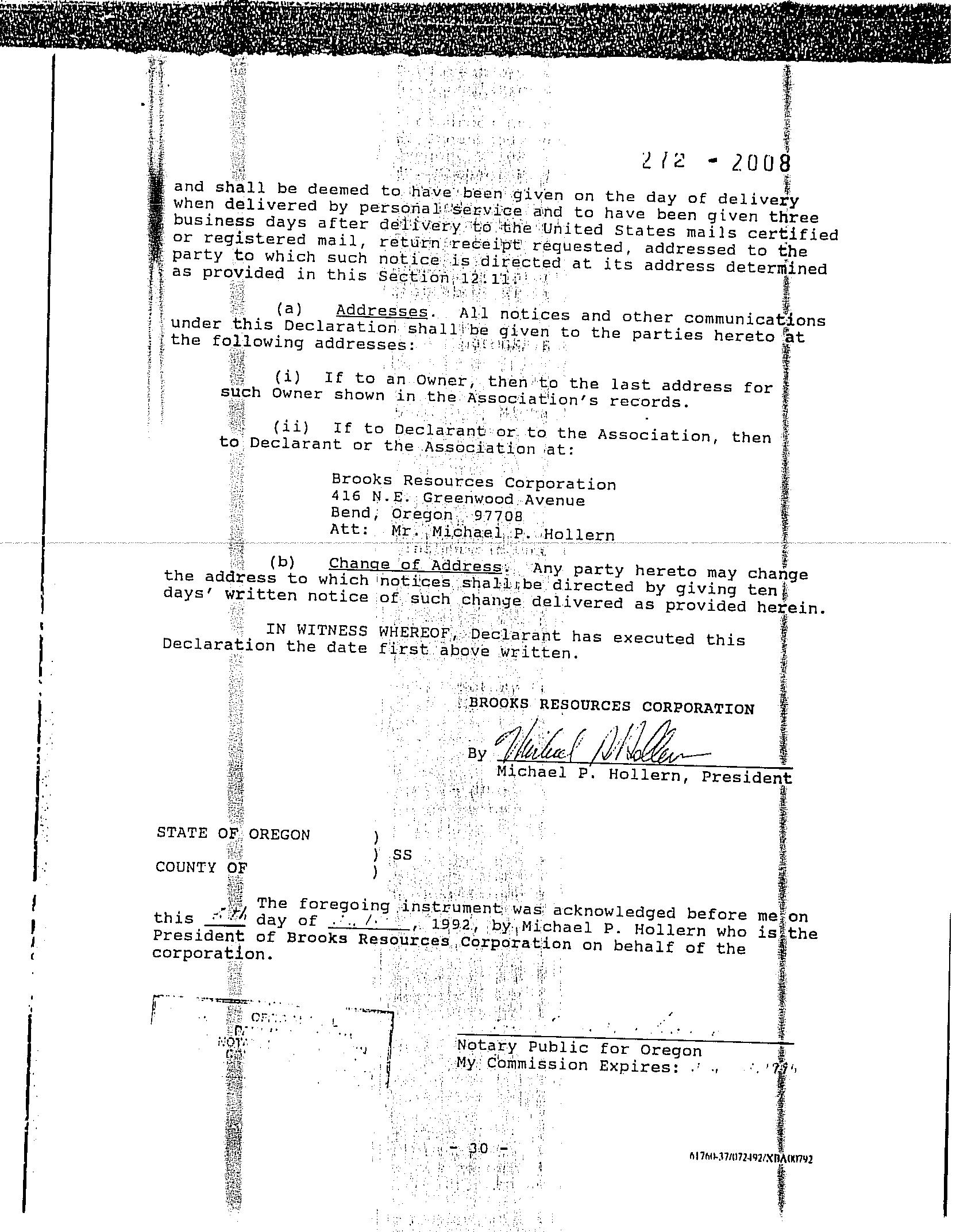
12.11 Notices and Other Documents. All notices and other communications under this Declaration shall be in writing -29- 61760-37/4072492/XHA(X1792
and shall be deemed to have been given on the day of delivery when delivered by personal service and to have been given three business days after delivery to the United States mails certified or registered mail, return receipt requested, addressed to the party to which such notice is directed at its address determined as provided in this Section 12:110
(a) Addresses. All notices and other communications under this Declaration shall be given to the parties hereto at the following addresses:
(1) If to an Owner, then to the last address for such Owner shown in the Association's records.
to
(ii) If to Declarant or to the Association, then Declarant or the Association at:
Brooks Resources Corporation
416 N.E. Greenwood Avenue Bend; Oregon 97708
Att: Mr. Michael P. Hollern
(b) Change 'of Address. Anyparty hereto may change the address to which notices shall be directed bygiving ten days' written notice of such change delivered as provided herein.
IN WITNESS WHEREOF, Declarant has executed this Declaration the date first above written.
BROOKS RESOURCES CORPORATION
Michael P. Hollern, President
STATE OF OREGON SS COUNTY OF
The foregoing instrument was acknowledged before me on this day of / 1992, by Michael P. Hollern who is the President of Brooks Resources Corporation on behalf of the corporation.
Notary Public for Oregon My Commission Expires:.
6176-37/0072492/XDAOK1792
STATE OF OREGON) 5S. COUNTY OF DESCHUTES)
I, MARYSUE PENHOLLOW, COUNTY CLERK AND RECORDER OF CONVEYANCES, INAND FORSAID COUNTY, DO HEREBY CERTIFY THATTHEWITHIN INSTRUMENT WAS RECORDED THIS DAY:
82 AIIS1 10:56
NO. 92-25570 DEPUTY FEE./55
DESCHUTES COUNTY OFFICIAL RECORDS
95-03265
AwbreyGlen
SUPPLEMENTAL DECLARATION FOR AWBREY GLEN 364 -2368
The undersigned ("Declarant") does' herebydeclare and provide that the property shown on the officialplat.of AWBREY GLEN HOMESITES, PHASE FOUR, City of Bend, Deschutes County, Oregon, shall be subject to the Declaration of Covenants, Conditions and Restrictions for Awbrey Glen Homesites, recorded August 4, 1992 in Volume 272, Page 1979 Deschutes County Official Records.
IN WITNESS HEREOF, BROOKS RESOURCES CORPORATION has executed this Declaration the 30th day of January 1995.
BROOKS RESOURCES CORPORATION
Michael P. Hollern, President State of Oregon, County of Deschute, s:
This inetrument was acknowledgod before mo on January 30, 1995 by Michael P. Hollern, President of Brooks Resources Corporation, an Oregon corporation, on behalf of the corporation.
Altarrecording,returt to: BEND TITLE COMPANY 1195N.W. WALL BEND BR
r
Nótary Public for Oregon My Commission Expires:$ 98
DESCHUTES COUNTY CLERK
CERTIFICATE PAGE
This pagemust be included ifdocument is re-recorded. Do Not remove from original document.
00105508200200572140070072 10/16/2002 02:35:20 PM
LICENSE
APPLICABLE PUBLIC FACILITY IMPROVEMENTS:
STREET
SEWER
WATER MASTER PLAN V OTHER
TheCITYOF BEND, an Oregon municipal corporation,hereinafter referredto as "CITY" and COPPERSTONE ASSOCIATES LLC, hereinafter referred to as "USER" agree as follows:
GENERALCONDITIONS
1. USER has received, read and understands City's public facility improvement policies which are attached tothis agreement. The terms used in this agreement havethe meanings assigned to them by City's policies unless specifically provided otherwise in this agreement.
1.1 USER desires the extension of public facilities to USER'Sproperty described on Exhibit "A"that is attached hereto andmade part of this agreement.
1.2 The USERand City intendthatthis agreement shall constitute a covenant running with the land, binding on the USER and the USER'S heirs, successors, or assigns.
1.3 USER agrees to pay applicable sewer, water and street System Development Charges (SDC's) inaccordance with City policies.
PROVISION OF PUBLICFACILITY IMPROVEMENTS
2. FACILITIES shall be suppliedonly through components constructed byCity approved contractor, installed to City Standards and Specifications and owned by City. All facilities except USER'S service connection lines shall be installed within publicright of ways or City easements. Easements shall be granted to City free and clear of all liens and encumbrances.
2.1 USER shallnotconnect to CITY'S facilities untilCity accepts facilities installedbyUSER in writing and a Maintenance Agreement betweenthe City andUSERis established.
2.2 USER shall promptly payall charges for City services when due. Charges shallbe as prescribed by the appropriate scheduleand may be changed fromtimetotime.
2.3 No other use of CITY services or CITY facilitiesshallbe permitted without express written consent of the CITY.
2.4
2.5
USER shall comply with all applicablegovernmental laws, rulesand regulations including but not limited to CITY ordinances, resolutions and the provisions of Citypublicfacilityimprovement policies as they now exist and as they may be changed from time totime. Any failure to comply with all terms andconditionsof this agreement shall entitle CITY to terminate facility improvement servicesat CITY'S sole discretion.
If USER'S property is outside the City and USER receives City water, sewer and/or street service, USER'S service may be terminated at anytime afterthreemonth's writtennotice.
EXTENSIONOF PUBLIC FACILITY IMPROVEMENTS
3. USER shall comply with the following conditions if components to USER'S property require extension ofsewer, water and street facilities.
3.1
3.2
USERagrees to perform allworknecessaryforthe construction of the public facility improvements as shown on engineered construction drawings for City of Bend Project Number PZ 99-357, approved by the City Engineer on May 30, 2002at USER'S soleexpense and in accordance with the City's Standards and Specifications, within one year unless extended by City in writing.
The person, firm or corporation performing the work shall have construction liability coverage. Coverage shallbeintheamount of a one million dollar combined single limit for bodilyinjury liability andproperty damage. USER shallholdCity harmless and indemnify City fromany liability of any kind in connection with activities resulting from this agreement.
3.3
USER agrees to submittothe City a statement ofallcostsincurred on the project upon completionof the project.
3.4 City will charge appropriate feesforservices rendered toUSER.
3.5 USER agreesto obtain an Oregon State Highway, City or Countystreet cut permit prior to any construction in rightof ways.
3.6 When required by CITY, USER agrees todeliver to CITY "AS BUILT" reproducible drawings of the completed work, signed by an Oregon professional engineer prior to acceptance of thework byCITY.
City of Bend Community Development Dept PO Box 431
Returnto
3.7 The total amountdue and payable upon signing thisagreement islisted on Exhibit "C".
3.8 USER hereby grants CITY a licenseto enter and remain on USER's property for the purpose of inspecting public facility improvements constructed pursuant to this Agreement, including,but not limited to,any water lines, meters, backflow prevention devices, sewer lines, streets, test cocksand other facilities.
ADDITIONALCONDITIONS
FORPROVISIONOF WATERFACILITIES
USER agrees to perform allwork necessary to installwater service lineswith meters and housings if required. Said installations to be completed in accordance with engineered construction drawings for City ofBend Project NumberPZ 99-357, approvedby the City Engineer on May 30, 2002 and City Standardsand Specifications. Themeter,tobe installed by contractor, must be stamped and registeredby CITY PublicWorks department prior to installation.
USER agrees to performallwork necessary to install on USER'S property at a Cityapproved locationa backflow preventiondevice approved by the Oregon StateHealth Division and the City of Bend Standards and Specifications if required. This device mustpass inspection by a certified backflow prevention inspector.USER agrees to have test cocks installed on this device as shown in the specifications. USER also agreesto comply with theannual requirement for checking thebackflow protection valvesat USER'S expense.
Not required
Double check typ ReducedPressure Type
FIRE SERVICES: When required, fire servicesshallbe constructed in accordance with engineered plans approved by the City Engineer], including locations of allfireservicesand associated backflow devices.
FOR PROVISION OF SEWER FACILITIES
An Industrial Discharge Permitmaybe required for some projects. If required, USER shall obtain this permit fromthe City of Bend Public Works Department.
FOR PROVISION OFSTREET FACILITIES
USER shallconstructall required public andprivatestreet improvements according to the attached City Street Policies. CITYshallreviewand approve all private street improvements in accordance with the City ofBend Zoning Ordinance.
PZ 99-357 WR/SLE
COPPERSTONE PHASES 2&3
Page 3 of 7
Return to CityofBend Community Development Dept PO Box 431 Bend OR 97709
LANDUSE DECISION REQUIREMENTS
USER shall comply with and meet all requirements specific to this development as stipulated in the City of Bend Land Use Decision and/or Development Agreement, including additionalconditions for publicfacility improvements not mentioned above.
BUILDINGPERMIT ISSUANCEPOLICY
USER acknowledges that City policy prohibits release of building permits untilall of the requiredpublic facility improvements for the project havebeen completed, approved by the City, and the one-year warranty (maintenance) periodhas begun.
SYSTEMS DEVELOPMENT FEE REIMBURSEMENT
USER understands and acknowledges ifmaster plan facilities, as defined and approved bytheCity Engineer, are constructed by the applicant and approved by the City, USER hasthepotential for a systemdevelopmentcharge reimbursement entitlement pursuant to City policy, rules, regulations and the MasterPlan Facility Reimbursement Agreement.
PZ 99-357 WR/SLE COPPERSTONEPHASES2&3 Page 4 of 7
Return to City ofBend Community Development Dept PO Box 431 Bend OR97709
DATED thisv day of August 200
USER BY: do Pon For Copperstone AssociatesLLC
STATE OFOREGON
County of Deschutes )ss )
This instrument was acknowledged before me on 5.6.02 by Holly Polis
Aulia a Mekimon
NOTARY PUBLIC FOROREGON MyCommission Expires: 9.28105
CITY
STATE OF OREGON ss
County of Deschutes
This instrument was acknowledgedbefore meonCctobu 1. 2002 by Deb Walker
NOTiOFOR NOTARYPUBLIC FOROREGON My Commission Expires: 8-3-03
LEGAL DESCRIPTION
COPPERSTONEPHASES 2 AND3
BEGINNINGAT THEINITIAL POINT, A 5/8"IRONRODWITH YELLOW PLASTIC CAPMARKED "W&H PACIFIC", SAID POINT BEING LOCATED ON THENORTH-SOUTHCENTERLINE OF SECTION 25, TOWNSHIP 17 SOUTH, RANGE 11 EAST, WILLAMETTE MERIDIAN AND THE SOUTHERLY RIGHTOF-WAYOF REGENCYSTREET,SAIDPOINT ALSO BEING LOCATED ON THESOUTHERLY BOUNDARYOF "COPPERSTONE, PHASE ONE", SAID INITIALPOINT BEARSSOUTH00°44'11"WEST,40.00 FEETFROM THE CENTER-NORTH 1/16CORNER OF SAID SECTION 25; THENCE ALONG SAIDSOUTHERLYRIGHT-OF-WAYTHEFOLLOWING THREE (3) COURSES: THENCE ALONGTHEARCOF A 210.00FOOTRADIUS CURVE TO THE RIGHT,THROUGH A CENTRALANGLE OF 79°55'27", AN ARCLENGTH OF 292.94FEET (THE CHORD OFWHICH BEARSSOUTH49°33'34" EAST, 269.76 FEET) TOA POINT OF REVERSE CURVATURE; THENCEALONG THE ARC OFA290.00 FOOTRADIUSCURVE TO THELEFT, THROUGHA CENTRAL ANGLEOF 52°38'40", AN ARC LENGTHOF266.46FEET (THE CHORDOF WHICHBEARSSOUTH35°55'11" EAST, 257.18FEET) TOA POINT OF TANGENCY;THENCESOUTH62°14'31"EAST,19.88 FEETTO THE WESTERLYRIGHT-OF-WAY OF MT. WASHINGTONDRIVE;THENCE ALONG SAID WESTERLY RIGHT-OF-WAY THE FOLLOWING FOUR (4) COURSES: SOUTH27°45'29" WEST,243.53FEET; THENCENORTH 62°07'57"WEST,3.14 FEET; THENCE SOUTH27°52'24" WEST, 524.37 FEET TOA POINT OFCURVATURE; THENCE ALONGTHE ARCOFA 599.86FOOT RADIUS CURVETOTHE LEFT, THROUGH A CENTRAL ANGLEOF 06°06'16", AN ARCLENGTH OF 63.91FEET(THECHORD OFWHICH BEARSSOUTH 24°49'16" WEST,63.88 FEET);TO APOINTON SAID NORTH-SOUTH CENTERSECTION LINE; THENCE LEAVING SAIDWESTERLY RIGHT-OFWAY AND ALONGSAIDNORTH-SOUTHCENTERLINE,NORTH00°44'11" EAST, 1128.43 FEET TO THE POINT OF BEGINNING.
PZ99-357 WR/SLE COPPERSTONE PHASES 2&3 Page 6of7
Return to City ofBend CommunityDevelopment Dept PO Box 431 BendOR 97709
EXHIBIT"C"
Engineering Fees
Grading drainage reviewsubmittal $650.00
Storm sewer piping fee75 If x $2.00/ft
Drywell, # of drywells 1 x $250.00 per drywell $ 250.00
Waterplanreviewsubmittal $650.00
Water line fee 659 If x $2.00/ft $1,318.00
Sewer plan review submittal $650.00
Sewerline fee 636 If x $2.00/ft
Manhole fee,#of manholes 7 x $250.00/manhole
Street review submittal$650.00 Street fee private If x $3.00/ft
Inspections
SCHUTESCOUNT
This page must be included if document is re-recorded. Do Not remove from original document.
After Recording, Return To:
Ball Janik LLP
15SW Colorado, SuiteK
Bend, Oregon 97702
Attn: Laura Craska Cooper
EASEMENT AND MAINTENANCEAGREEMENT
This EASEMENT AND MAINTENANCEAGREEMENT (this"Agreement") is made as of this 13 day of June 2003 by and among AWBREY GLEN HOMEOWNERS ASSOCIATION, INC., an Oregon nonprofit corporation ("HOA"), andBROOKS RESOURCES CORPORATION, an Oregoncorporation ("BRC"). EachofHOA and BRC makesthis Agreement on behalfof itself andits respective successors and assigns.
Recitals:
Resaried byAmenfitle as an accommodation only. No liability is accepted for the conditionof title or for the validity,sufficiency, or effect ofthis document.
A. HOA is the owner of certain real property located inthe City of Bend, Deschutes County, Oregon more particularly described on the attached ExhibitA (the"HOA Property"); andBRCisthe owner ofcertain real property located inthe City of Bend, Deschutes County, Oregon more particularly described on the attached ExhibitA ("BRC Property"). HOAand BRC are hereinafter referred to individually asa "Party" and collectively as the"Parties."
B. The HOA Property andtheBRC Property are adjacent to eachotherin several places.The parties now desire to obtainand grant various easements and provide for the maintenance ofcertain easement andother areas, all on the terms andconditions contained herein.
Agreement:
NOW, THEREFORE, in consideration ofthepromises contained herein and other good andvaluable consideration, the receipt and adequacy of which is hereby acknowledged, the Parties hereto agree as follows:
1. RECIPROCAL DRAINAGEAGREEMENT
1.1 Agreement to Cooperate in Good Faith. HOA and BRC hereby agreeto cooperate in good faith in thefuture as necessarytodivert storm water runoff awayfrom improvements on the HOA Property and the BRC Property whenthe same is likely to cause flood damage to such improvements. The foregoing shall mean thatintheeventthatfuture storm(s) cause flooding that damages or threatensdamage to improvements on either Party's property, the other Party shallprovide sucheasements as are reasonably necessary to permit constructionof drainagefacilities toprevent suchdamage from occurring in the future. The grant of easements shall be at no cost, but the cost ofconstructing the drainage facilities shallbeborne by the Party whose property hasthe storm water that must be drainedtoprevent future harm. If both Parties will benefitfrom theconstructionofsuch drainage facilities, they shall share the costs equitably. Notwithstanding the foregoing, in no event shalleither Party be required to relocate
After recording, return to Amerititle 15 OREGON AVENUE, BEND
L:\Awbrey Glen AGTurnoverEasement and Maintenance Agreement-fina13-23-03.DOC
improvements toaccommodate drainage facilities for the benefit oftheother Party's property. Any easements granted pursuant to thisSection 1.1shall be in writing and shall berecorded inthe realpropertyrecordsofDeschutes County, Oregon.
Inthe event that runoff from one Party's property results in pooled water or damage to the otherproperty, the Partiesshallcooperate in good faith inthe selection andconstruction of drainage facilities to minimize such future pooling or damage. Totheextenteasements are necessary to permit the constructionof such facilities,the provisions of the foregoingparagraph relatingtothegrant of easements shall apply. The cost of such drainagefacilitiesshallbe borne by the Party from whose property the storm water is draining.
1.2 Use/Construction. In the event of the grant of an easement pursuant to Section 1.1, theParties agree, andthe easement document shall provide, thatthe Partygranting the easement (the "Grantor") shallhavethe right to relocate such easement and the drainage facilities thereon if the Grantor believes the same is necessary to permit Grantor to construct or reconstruct improvements on Grantor's property. Such relocation shall be at Grantor's expense, but the beneficiary of the easement (the"Grantee") shallcooperate with Grantor in good faith as necessary to facilitate such relocation, including byexecuting anamendment to the easement document.
2. FISHING EASEMENT
2.1 Grant. BRC hereby grants to HOA for itself anditsmembersthe following easements: (i) a non-exclusive,perpetual easement (the"FishingEasement") to engagein fly fishing inthat certainlake commonly known as BunnyLakeand as depicted on attached Exhibit ("Bunny Lake"); and (ii) a non-exclusive,perpetual easement (the "Bunny Lake Access Easement") over and across that portion ofthe BRC Pròperty identified on attached Exhibit B as the "Bunny Lake AccessArea Easement" as reasonably necessary toutilizethe Fishing Easement.
2.2 Stocking. HOA agreesto reimburse BRC for one-half (1/2) ofthe costs incurred by BRC from time totimein stocking Bunny Lake with fish. BRC shall have no obligation to stock Bunny Lake at any time or at all; provided, however, in the event thatBRC elects not to stock Bunny Lake, HOA, with the prior written approval of BRC, may do so at its own cost and expense in compliance with all applicable laws. In suchevent, BRC shall not unreasonably withhold its consent. Regardless of which Party stocks Bunny Lake, BRC shall have no obligation for maintaining Bunny Lake and no liability forthe health of, or any damage to or death of,anyfish.
2.3 Compliance with Rules. In using the Fishing Easement andthe Fishing Access Easement, theHOAandits members shall strictly comply withallrules and regulations established by BRCfromtime to time.
3. MAINENTRYEASEMENT;MEDIAN EASEMENT
3.1 Grant. BRC hereby grants to HOA a non-exclusive,perpetual easement over and across thatportionof the BRCProperty described on Exhibit B as the"MainEntry Easement
L:Awbrey Glen\AGTurnover\Easement and Maintenance Agreement-fina 13-23-03.DOC
Area" for maintenance purposes as described in Section 3.2. HOA hereby grants to BRC a nonexclusive, perpetual easement over and across that portion of the HOAproperty described on Exhibit B as the "Awbrey Glen Drive MedianEasementArea"for landscape maintenance purposes as described in Section3.2.
3.2 Maintenance. BRCshall maintain the Main Entry Easement Area and the Awbrey Glen Drive Median Easement Area, including theentry sign monument,in good condition and repair. If HOA desires to enhance theMainEntryEasement Area, HOAmay enter the Main Entry Easement Area and enhance the landscaping and/or monument sign thereon; provided, however, HOA shall first obtain the written consent of BRC, which consent shall not be unreasonably withheld, conditioned or delayed. Neither Party shall have the right to remove or alter the entrysign monument intheMain Entry EasementAreawithoutthepriorwritten consent oftheother Party, which consent may be withheld in either Party's sole discretion. BRC shall maintain the Awbrey GlenDriveMedian Easement Area in good condition andrepair.
4. MONUMENT EASEMENT
4.1 Grant. BRC hereby grants to HOA a non-exclusive,perpetual easement over and across that portionof theBRC Property located at the intersection ofPutnam Drive and Champion Circle and described on Exhibit B as the "Monument Easement Area" for maintenance purposes.
4.2 Maintenance. HOA shall maintain theMonumentEasement Area, including all landscaping, in good condition and repair. Neither Party shallhavethe right to remove or alter the entry sign monument in the MonumentEasementArea without the prior writtenconsent of the other Party, which consent may bewithheldineitherParty's sole discretion.
5. IRRIGATION COSTS; ROADMAINTENANCE
ThePartiesagree that (i) BRC currentlyirrigates some portions oflandscaping that exist on HOA property, including parks, landscape strips and entry areas depicted on Exhibit C and (ii) BRC is entitled to receive reimbursement for the costs ofsuch irrigation. The Parties further agree that (i) pursuant to the plat of Awbrey Glen,BRC, as the owner ofthe BRC Property,has the right to use the roads within Awbrey Glen and (ii) HOA is entitled to receive reimbursement for BRC's pro rata share of the costs of ordinary maintenance, repair and/or replacementof such roads,based upon proportional usage.Eventhough such amounts are not likely to be equal, each Party to date has simply agreed to treat the amounts as if they were equal and completelyoffset eachother. Notwithstanding the foregoing, eitherParty may, at any time, suspend such setoff agreementand request negotiation withthe other Party to determinethe amounts properly owed for the irrigation androad maintenance describedinthisSection5. Insuch event, the parties shall negotiate in good faith to determinethe costs to BRCofirrigatingHOA's landscaping (based upon BRC's actual costs, including direct and indirect) and BRC's fair share of road maintenance expenses (based uponthe proportion of total Awbrey Glen road use attributable to BRC). In no event shall this Section 5be construed as obligating BRC to irrigate any landscaping or other property belonging to H . L:\Awbrey
6. DAMAGE CAUSEDBYONE PARTY
Each Party (the "Responsible Party") shall be responsible for thecosts of any maintenance or repairs toany portion of the other Party's propertynecessitated by the willful or negligent actions or omissions of theResponsible Party or the ResponsibleParty's employees, agents, members, tenants, guests, contractors, or invitees.
7. GENERAL PROVISIONS
7.1 Compliance with Laws. EachPartyshall comply withall applicable laws in using the easement granted hereunder.
7.2 Payment of Sums Due Hereunder. All sums due under this Agreement shall be paid within thirty (30) days of receipt of a request for the same accompanied by reasonably detailed documentation evidencing the amounts spent and calculation ofthe amounts forwhich payment is sought.
7.3 Indemnification. Each Party (the"Indemnifying Party") shall indemnify andhold theother Party harmlessfrom any loss, claim, or liability arising in any mannerout ofsuch Indemnifying Party's negligent use ofthe easements granted hereunder. This indemnity agreement shall include any damage to property or for personal injury.
7.4 CovenantsandEasements to Run withLand. Each covenant andall easements madeandgranted pursuant to this Agreement shallbe permanent andshall run with the land asto allpropertybenefitedandburdenedby such covenant and easements, including any partition or division of suchproperty. The rights, covenants,and obligations contained in thisAgreement shall bind, burden, and benefit the Parties and their respective successors, assigns,lessees, mortgagees,andbeneficiariesunder any deedoftrust.
7.5 Mediation/Attorneys' Fees. In the event of any dispute or disagreementrelating to or arising out ofthis Agreement, the parties agreeto submit the same to non-binding mediation before a mediator agreeable to both parties. Both parties agree that they will use good faith efforts to reach a resolution of the dispute.
If the dispute is not resolved bymediation, notwithstanding the good faith efforts of both parties, the parties shallhavethe right toany and all remediesallowedby law, excepting thatboth parties waivetheir right to jury trial andagreethat any case case brought in Oregon Circuit Court shall betried to a court and not a jury.
Should acase bebroughtin circuit court, the prevailing party, as adjudged by thecourt, or the appellate court inthe case of an appeal, shall be entitled to recover its attorney fees, costs and expert witness fees incurred as a result ofthe action. However, no attorney fees,costs or expert witness feesshallbe paid to a party if thatpartydid not make a reasonable attempt toresolvethe matter inmediation as set forthabove.
7.6 Modification. The terms of this Agreement may be modified only upon the consent oftheParties as evidencedby theirexecutionof a written instrument that isrecorded in thedeed records of Deschutes County, Oregon.
7.7 Entire Agreement. This Agreement constitutes theentireagreement between the Parties. Norepresentations,warranties, or promises pertaining to this Agreement or any property affectedbythisAgreement havebeen made by, or shall be binding on,eitherofthe Parties, except as expresslystatedinthis Agreement.
7.8 Severability. The invalidity or unenforceability of any provisionof this Agreement, with respect to a particularParty or set ofcircumstances, shall not in any way affect the validity or enforceability of any other provisionhereof, or the same provision when applied to the other Party or a different set ofcircumstances.
7.9 Further Assurances. Subject totheterms and conditions hereof, eachPartyagrees to use allreasonableefforts to do, orcause to be done, allthings necessary, proper or advisable under applicablelawsand regulations, to consummate thetransactionscontemplated bythis Agreement as expeditiously as practicable, including, without limitation, the performance of such further acts or the executionand delivery of any additional instruments or documents as the other Party may reasonably request in order to carry out thepurposesofthis Agreement andthe transactions contemplated hereby.
IN WITNESS WHEREOF, thePartieshave executedthis Agreement as ofthe date first written above.
AWBREYGLEN HOMEOWNERS ASSOCIATION, INC., an Oregon nonprofit corporation
By: Name: MARK P. RETSINGE Title: PRESIDENT
BROOKSRESOURCES CORPORATION, an Oregoncorporation
Name: Kik Schue/ Title: President
STATEOF OREGON ) ) ss. County of )
L:\Awbrey Glen\AG TurnoverEasement and Maintenance Agreement-fina 13-23-03.DOC
"HOA"
"BRC".
The foregoing instrument was acknowledged before me on this 13 day of Ahunc 2003 by mork Bcisinser, the brcsident of the AwbreyGlen Homeowners Association, Inc., an Oregon nonprofit corporation, on behalf of the corporation.
OFFICIAL SEAL
LAURA MC GINLEY
NOTARY PUBLIC-OREGON COMMISSION NO. 360008 MYCOMMISSION EXPIRES AUG. 1, 2006
STATEOFOREGON
County of 25chutes
OFFICIAL SEAL
LAURA MC GINLEY NOTARY PUBLIC-OREGONCOMMISSION NO. 360008 MYCOMMISSION EXPIRESAUG. 1, 2006
) ss. La siley
Notary Publicfor Oregon My CommissionExpires: 8-1-0
The foregoing instrument was acknowledged before me on this 12 day of Aune 2003 by kik scheeales the fresdeur ofBrooksResources Corporation, an Oregon corporation, on behalf of the corporation.
A parcel ofland located intheeast one-halfof thesouthwestone-quarter and the southeast one-quarter ofSection 24,the northeast one-quarter of thenorthwestone-quarterandthe north one-half of thenortheast one-quarter of Section 25, Township 17 South,Range 11 East, Willamette Meridian, City of Bend, Deschutes County, Oregonbeing more particularly described as follows:
Beginning atthenorthwest corner ofLot 68, Awbrey Glen Homesites, Phase Four; thence along the northerly boundary of said Awbrey Glen Homesites, PhaseFourfor the following four courses: South 17°27'27" West, 185.86 feetto a point ofnon-tangent curvature; thence along the arc of a 265.00 foot radius curve to the right, through a central angle of 21°15'38", anarc distanceof98.33feet(the chord ofwhich bears North 57°32'40" West, 97.77 feet) to a point of compound curvature; thence along the arc of a 200.00 footradius curve to the right, through a central angle of 77°24'24", an arc distance of 270.20 feet (the chord of which bears North 08°12'39" West, 250.12 feet) to a point of compound curvature; thence along the arc of a 213.00 foot radius curve to the right, through a central angle of 19°48'32", anarc distance of73.64feet (the chord of whichbearsNorth40°23'50" East, 73.27 feet) to a point on the southerly boundary ofChampion Ridge, Phase Five; thence along the southerly and easterlyboundary of said Champion Ridge, PhaseFiveforthe following twelve courses: thence continuing along the arc ofa 213.00 footradius curveto the right, through a central angle of 16°37'30", anarc distance of 61.80 feet (thechord of which bears North 58°36'51" East, 61.59 feet) to aa point oftangency; thence North 66°55'36"East, 118.08 feet to a point of curvature; thence along the arc of a 255.00 foot radius curve to the left, through a central angle of38°50'36", an arc distanceof172.88 feet (the chord of which bears North 47°30'24" East,169.58feet) to a point of non-tangency; thence South 13°45'18" West, 162.31 feet, thenceSouth 88°12'19" East, 115.00 feet; thence North 89°49'31" East, 368.82 feet; thence North 83°55'12" East, 95.22 feet; thence North 78°33'55" East, 103.15 feet; thenceNorth 68°50'11" East,153.32 feet; thenceNorth 58°10'39" East, 104.82 feet; thence North 20°37'41" West, 220.65 feet;thence North37°04'03" West,108.66 feet to the easterly most point of Champion Ridge, Phase Four; thence along the east boundary of said ChampionRidge, Phase Four, North 38°10'01" West, 516.00 feet to the easterly most point ofChampion Ridge, Phase Two;thence along the east boundary ofsaid Champion Ridge, Phase Two forthe following two courses; thence North24°29'04" West, 306.19 feet; thence North 00°24'43" East, 123.37 feet to thesoutheast corner of Champion Ridge, Phase One; thence along the east boundary of saidChampion Ridge, PhaseOneforthe following four courses: thenceNorth 00°24'43" East, 90.55 feet; thence North 14°58'39"East,240.89 feet; thenceNorth 33°05'54" East, 140.50 feet; thenceNorth02°00'11" East, 183.18 feet to a point on the southerly boundary ofAwbrey Glen Homesites, PhaseTwoand a point of nontangentcurvature;thence along the southerly boundary of said Awbrey Glen Homesites, PhaseTwoforthe following fourteen courses: thence along the arc of a 270.00footradius curve to the right,through a central angle of 27°31'07", an arc distance of 129.68 feet (the
chordof which bears North 64°53'30" East, 128.44 feet) to a point of non-tangency; thence South 05°47'30" East, 234.86 feet;thenceSouth 00°14'04" East, 197.62feet; thence South 12°55'32" West, 219.15 feet; thenceSouth 23°02'45" East, 130.61 feet; thence North 84°16'20" East, 165.46 feet; thence North 44°34'01"East, 171.08 feet; thenceNorth 19°17'55" East, 99.69 feet; thenceNorth 02°42'03" East, 207.89feet;thenceNorth 01°04'38" West, 125.35feet; thence North 03°24'35" East, 207.52 feet to a pointof nontangent curvature;thence along the arc of a 330.00 footradius curve to the left, through a central angle of 10°35'11", an arc distanceof 60.97 feet (the chordofwhichbearsNorth 74°12'36" East,60.89 feet) to a pointof tangency; thenceNorth68°55'00"East, 81.74feet; thence North 21°05'00"West, 10.00 feet to a point on thesouthwesterly boundaryof Awbrey GlenHomesites, Phase One; thence along the southwesterly boundary of said AwbreyGlen Homesites, Phase Onethe following twenty-three courses: thence North 68°55'00" East, 111.74feet to a pointofcurvature;thencealong the arc of a 380.00 foot radius curve to the right, through a central angle of24°10'15", an arc distance of 160.31 feet (the chordof which bears North 81°00'04" East,159.12 feet) to a point of tangency; thence South 86°54'48" East, 128.99 feet to a point of curvature; thence along the arc of a 230.00 footradius curve to the right, through a central angle of 55°12'40", anarc distanceof221.63 feet (the chordof which bearsSouth 59°18'28" East, 213.16feet) to a point oftangency; thence South31°42'08" East, 60.82feet to a point of curvature; thence along the arc of a 220.00footradius curveto the left, through a central angleof34°47'28", an arc distance of 133.59 feet (the chordof which bearsSouth49°05'52" East, 131.54 feet) to a point of compound curvature;thence along the arc of a 145.00 foot radius curve to the left,through a central angle of 26°29'40", anarc distanceof 67.05 feet (the chord of whichbears South 79°44'26" East,66.45 feet) to a point of non-tangentcurvature; thence along the arc ofa 310.00 foot radius curve to the left, through a central angle of 20°47'04", anarc distance of 112.45 feet (the chord ofwhich bearsSouth 31°55'48" East, 111.84 feet) to a pointof tangency; thenceSouth42°19'20" East, 37.84feet toa point of curvature; thence along the arc of a 310.00 foot radius curve to the left,through a central angle of 13°32'40", an arc distanceof 73.28 feet (thechord ofwhichbearsSouth 49°05'40" East, 73.11 feet) to a point of non-tangency; thence South 07°56'03" East, 196.40 feet; thenceSouth03°13'32" East 496.26 feet; thence South25°14'05" West, 228.40feet;thenceSouth30°49'43"West, 112.71 feet; thenceSouth 75°55'58" East, 183.37feetto a point of non-tangent curvature; thence along the arc of a 285.00 foot radius curve tothe left,through a central angle of 22°36'13", an arc distance of 112.43 feet (the chord ofwhichbearsSouth 31°54'18" West, 111.71 feet) to a point of tangency; thenceSouth 20°36'12" West, 129.22 feet to a point of curvature; thence along the arc of a 215.00 foot radius curve to the right, through a central angle of 23°18'28", an arc distance of 87.46 feet (the chordofwhichbearsSouth 32°15'26" West,86.86 feet) to a point of tangency; thenceSouth43°54'40" West, 100.53feet to a point ofcurvature;thence along the arc of a 285.00 foot radius curve to the left, through a centralangleof16°32'49", anarc distance of 82.31 feet (the chordofwhichbears South 35°38'16" West, 82.02 feet) to a point of tangency;thence South 27°21'51" West,59.35feet to a pointof curvature; thencealong the arc of a 265.00 foot radius curve to the right, through a central angle of 17°32'22", an arc distance of 81.12 feet (the chord of whichbears South36°07'56" West, 80.81 feet) to a point of tangency; thence South 44°54'01" West, 93.36 feet to a point on the northerly boundary of said Awbrey Glen Homesites, Phase Four; thence along northerly boundary of saidAwbrey Glen Homesites, Phase Four forthe
following thirteen courses: thence North 45°05'59" West,3.54 feet; thenceSouth 44°54'01" West, 18.06 feet to a pointof tangency; thence along the arc of a 115.00 footradius curve to the right, through a central angle of 08°09'45", anarc distance of 16.38 feet (the chord of which bears South48°58'46" West, 16.37 feet) to a point of reverse curvature; thence along the arc of a 185.00 foot radius curve to the left,through a central angle of 14°57'01", an arc distance of48.27 feet (the chord of which bears South 45°35'08" West, 48.14 feet) to a point of tangency; thence South38°06'46" West, 42.62 feet to a pointoftangency;thence along the arc of a 265.00 foot radius curve tothe left, through a central angle of 34°43'15", an arc distance of 160.59 feet (the chord ofwhichbearsSouth55°28'24" West, 158.14 feet) to a point of tangency;thenceSouth72°50'01" West, 212.28 feet; thence North 20°48'11"West, 171.68 feet; thenceSouth72°29'02"West,245.84feet;thenceSouth81°35'43" West, 354.74 feet; thenceSouth 88°30'49" West,235.85 feet;thence North 87°25'22" West, 360.00 feet; thence North 79°09'37" West, 120.00 feet to the northwest corner ofsaid Lot 68, Awbrey Glen Homesites, Phase Fourandthe point of beginning.
EXHIBIT 'A' continued
GolfCourse Parcel 'B'
A parcel ofland locatedinthe east one-halfofthesouthwest one-quarter of Section 24, and the northeastone-quarter ofthe northwest one-quarterof Section 25, Township 17 South, Range 11 East,WillametteMeridian,City of Bend, Deschutes County, Oregon being more particularly described as follows:
Beginning atthe southwest corner of Lot 83, Pine Canyon, Phase Six, said point being on the north-southcenterlineof the southwest one-quarterof saidSection 24; thence along said north-southcenterline South 00°37'06"West, 1,810.46 feet to the west 1/16 cornercommon to said Sections 24 and 25, said pointbeing the northwest corner of Lot 156, Awbrey Glen Homesites, Phase Seven;thence along the northerly boundary ofsaid Awbrey Glen Homesites, Phase Sevenfor the following seven courses: thence South 53°48'51"East, 120.47 feet; thence South 36°26'51" East, 106.14 feet; thenceSouth 59°43'58" East, 71.83 feet;thenceSouth 24°42'59" East, 73.42 feet; thence South40°16'45" East, 133.98 feet; thence South33°00'17" East, 141.86 feet; thence South 43°48'49" East, 142.38 feet to a point on the westerly boundary of Champion Ridge, Phase Five; thence along the westerly boundary of saidChampionRidge, Phase Fiveforthe following two courses: thence North 66°55'36" East, 118.08 feet to a point of curvature; thence along the arc of a 195.00 foot radius curve to the left, through a centralangleof 57°17'24", an arc distance of194.98 feet (thechord of which bearsNorth 38°16'54" East, 186.96feet) to a point on the southerly boundary of ChampionRidge, Phase Four; thence along the southwesterly boundary of said Champion Ridge, Phase Four for the following six courses: thence South 50°26'37" West, 92.34feet; thenceNorth 09°40'19" West,60.00feet; thence North 49°35'00" West, 443.10 feet; thence North 48°33'07" East,71.57 feet; thence North 15°48'27" East, 78.76 feet; thence North 79°37'19" East,63.22 feet to a point on the westerlyboundary ofChampion Ridge, Phase Three;thence along the westerly boundary ofsaidChampion Ridge, Phase Three forthe following eight courses: thence North 10°22'41" West, 138.47 feet to a point of curvature; thence along the arc of a 280.00 foot radius curveto the right, through a central angleof 11°07'39", anarc distance of 54.38 feet (the chordof which bears North 04°48'52" West,54.29feet) to a point ofnon-tangency; thence South 80°34'07" West, 75.00 feet; thence North 47°10'02" West, 74.15 feet; thence North 05°18'42" East, 78.27 feet; thence North 16°46'03" East, 69.70 feet; thenceNorth 04°23'38" East, 260.83 feet; thence North 05°37'50"West, 36.01feet to the southwest corner ofChampion Ridge, PhaseOne; thence along the westerly boundary of said Champion Ridge, PhaseOneforthe following two courses: thence North 05°37'50" West, 248.52 feet; thence North 00°34'11" East, 139.87 feettothe southwest corner ofPine Canyon, Phase Five; thence along the westerly boundary of said Pine Canyon, Phase Five for the following eleven courses: thence North 20°25'32" West, 112.08 feet; thence North11°29'30" West, 110.07 feet; thence North 13°36'30" East, 78.31 feet; thenceNorth 19°57'30" West,65.95 feet; thence North 05°13'20" East, 100.55 feet; thence North 04°54'49" East, 95.75 feet; thenceNorth 23°36'51" East, 64.55 feet; thenceNorth09°20'06" East, 39.60 feet; thence North 12°41'09" East,102.24 feet; thenceNorth 07°23'08" East, 92.19 feet; thence North 01°27'51" East, 131.66 feet to a point on the easterly boundary of said Pine Canyon, Phase Six; thence along
the easterly andsoutherlyboundary of said Pine Canyon, Phase Six for the following five courses: thence along the arc of a 280.00 foot radius curve to the right, through a central angle of 10°23'50", an arc distanceof50.81feet (the chord of which bears North 88°43'02" West, 50.74feet) to a point of non-tangency; thence South 03°16'26" West, 63.48 feet; thence South 49°18'23" West, 59.05 feet; thence South 09°53'24"West, 158.40 feet; thence North 86°39'12" West, 198.20feet to said southwest corner of Lot 83, Pine Canyon, Phase Six and thepoint of beginning.
30273-parcel b legal.doc 5
EXHIBIT 'A' continued
Golf Course Parcel 'C'
A parcel of land located in the northeast one-quarterof the southwestone-quarter, andthe east one-half ofthe northwest one-quarter, and the east one-halfof Section 24, Township 17 South, Range 11 East, Willamette Meridian, Cityof Bend, Deschutes County,Oregonbeing more particularly described as follows:
Beginning at the center-west one-sixteenth corner (C-W 1/16) of said Section 24; thence along the north-south centerline of the northwestone-quarter of said Section 24, North 00°44'09" East, 392.40feet to a point on the northerly lineof that parcel of land described in deed in Volume 207, Page 896 of theDeschutes County Official Records; thence leaving saidnorth-south centerlineand alongsaid northerly line for the following three courses: thence North 13°07'35" East, 232.28feet; thenceNorth32°34'00" East, 1,159.79 feet; thenceNorth 45°04'39" East, 189.48 feet; thence North 39°46'30" East, 80.80 feet; thence North36°34'13" East, 83.52 feet; thence North 53°24'25" East, 164.72 feet; thence South 69°51'23" East,175.68 feet; thenceSouth 50°01'27" East, 134.94feet to a point10feet northerly of thenorth edge of the existing paved golf course cart path; thence following approximately 10 feet northerly ofsaid north edge of paving for the following two courses: thence North 63°24'42" East,121.32 feet to a point of tangency; thence along the arc of a 37.25 foot radius curve to the right, through a central angle of 142°21'54", anarc distance of 92.56 feet (the chord of which bears South45°24'21" East, 70.52 feet) to a point of nontangency; thence South 56°20'50"East, 87.67 feet; thence South 46°14'35" East, 104.11 feet; thence South46°40'30" East, 45.11 feet; thence South 26°57'23" West, 145.20feet; thenceSouth 63°21'26" East, 129.97 feet; thence North 68°41'08" East,107.95feet; thence North 15°53'11" East, 160.18 feet to a point on thesouth line of that parcel ofland described in deed in Volume 335, Page 2801of the Deschutes County Official Records; thence along saidsouthlinefor the following two courses: thence South 89°58'09" East, 272.43 feet; thence North 54°45'24" East, 510.00 feet to a point on the westerly line of that parcelof land described indeed in Volume 105, Page 1467 of the Deschutes County Official Records; thence along said westerly line, South 44°29'29" East, 215.70 feet to a point on the northerly right ofway of Putnam Road as described indeedinVolume 282, Page 2211 of the Deschutes County Official Records; thence along the northerly and westerly right of way of said PutnamRoad forthe following twelve courses: thence South 43°44'31" West, 18.62 feet; thence South 46°01'54" West,39.67 feet to a point of curvature; thence along the arc of a 280.00 foot radius curve to the left, through a central angleof 104°16'33", an arc distance of 509.59 feet (the chord ofwhich bears South 06°06'22" East, 442.11feet) to a point of reverse curvature; thence along the arc of a 220.00 foot radius curve to the right, through a central angle of 61°33'00", anarc distance of 236.34 feet (the chord of whichbearsSouth 27°28'09" East, 225.13feet) to a pointof tangency; thence South03°18'21" West, 239.16 feet to a point of curvature; thence along the arc of a 530.00footradius curve to the left, through a central angle of05°42'45", anarc distance of 52.84 feet (the chordofwhichbears South 00°26'59" West, 52.82 feet) to a point of tangency; thence South02°24'24"East, 197.80 feet to a point of curvature;thence along the arc of a 330.00 footradius curve to the left,through a central angle of 17°24'02", an arc distanceof100.22 feet (the chord of which
bears South11°06'25"East,99.84feet) to a point of tangency; thence South 19°48'26"East, 50.46 feet to a pointof curvature; thencealong the arc of a 270.00 footradius curve to the right, through a central angle of 15°04'10", anarc distance of 71.01 feet (the chordofwhich bears South 12°16'21" East, 70.81 feet) to a pointof tangency; thence South 04°44'16" East, 50.79 feet to a point of curvature; thence along the arc of a 330.00 footradius curveto the left,through a central angle of07°43'13", anarc distanceof 44.47 feet (the chordofwhich bears South 08°35'53" East, 44.43 feet) to a point on thewesterly boundary of Awbrey Glen Homesites, Phase Five and a point of non-tangency;thence along the westerlyboundary of said Awbrey Glen Homesites, PhaseFiveforthe following three courses: thenceSouth 66°31'59" West,53.30 feet; thenceSouth17°06'11" West, 368.54 feet; thence South 18°42'46" West, 315.87 feetto a point on the northerly boundary ofHomes at Vardon Court; thence along the northerly boundary of HomesofVardon Court for the following two courses: thence South 20°50'10" West, 153.04 feet; thence South 77°13'10" West, 222.81 feet to thesoutherly most point of Awbrey Glen Homesites, Phase Six; thence along the east, north, and west boundariesofsaid Awbrey Glen Homesites, PhaseSix for the following twenty-nine courses: thence North53°38'43" East, 131.71 feet; thence North 01°40'35" East, 98.68 feet; thence North07°03'38" East, 130.32 feet; thence North 09°00'07" East, 130.70 feet; thence North 11°53'14"East, 131.55feet; thence North 14°23'53" East, 157.36 feet; thenceNorth 04°01'55" East, 147.68 feet; thence North 12°06'10" West, 148.18 feet; thence North 20°39'21" West, 132.35 feet; thence North 21°21'35"West,183.84feet; thence North 09°59'14"West,226.49 feet; thence North 06°09'08" West, 160.61 feet; thenceNorth 07°39'15" East, 134.11 feet; thenceNorth 50°29'31" West, 117.10 feet; thence South89°56'29" West,242.89 feet; thence South 74°32'27" West, 227.97 feet; thence South 13°56'36"West, 51.07 feet; thenceSouth 09°48'06" East, 52.33 feet; thence South 02°57'45" West, 143.95 feet; thence South 08°42'54" West, 115.08 feet; thence South 09°42'46"West, 344.10 feet; thence South 12°58'45" West, 131.97 feet; thence South11°07'50"West,131.30 feet; thence South 07°51'02" West, 130.45 feet; thenceSouth 09°38'30"West,130.87 feet; thence South 30°37'10"East, 182.95 feet; thenceSouth 10°43'15" West, 160.44 feet; thence South 06°05'28"West, 69.41 feet; thenceSouth 10°21'32" East,64.48feet to the northwest corner of Awbrey Glen Homesites, PhaseOne; thence alongthewest boundary of said Awbrey Glen Homesites, Phase One forthe following six courses: thence South 14°07'01" East, 52.63 feet; thence South 01°49'45" West, 199.65 feet; thenceSouth 05°30'07" East, 231.07 feet; thence South 06°57'17"East, 252.20 feet; thenceSouth04°50'11" West, 105.49 feet; thence South 21°05'00"East, 49.81 feet to thenortheast corner of Awbrey Glen Homesites, Phase Two; thence along thenorth boundary of said Awbrey Glen Homesites, Phase Two forthe following two courses: thenceSouth68°55'00"West,81.74feet to a point of curvature; thence along the arc of a 270.00 foot radius curve to the right,through a central angle of 10°35'11", an arc distance of 49.89 feet (the chordofwhich bears South74°12'36" West, 49.82 feet) to the initial point of Pine Canyon, PhaseOne and a point of nontangency; thence alongthe east boundary ofsaid Pine Canyon, Phase Onefor the following three courses: thenceNorth 10°48'49"West, 144.69 feet; thence North 09°08'15" West, 528.06 feet; thenceNorth 07°52'08" West, 30.52feettothesoutheast corner of Pine Canyon, Phase Two; thence along the east and north boundary of said Pine Canyon, Phase Two for the following five courses: thence continuing North 07°52'08" West, 217.59 feet; thenceNorth 01°17'26" West, 481.64 feet; thence North 00°44'39" East, 302.09 feet; thence
North 85°13'39" West, 162.16feet; thence South31°52'45" West, 185.99feet to a point on thenorth line ofCommon Area "D" (Runyon Court) of said Pine Canyon, Phase Two; thence along the north and west lines ofsaidCommon Area "D" (Runyon Court and McCready Drive) for the following seven courses: thence along the arc of a 50.00 foot radius curve to the left, through a central angle of 164°31'33", anarc distanceof 143.58 feet (the chord of which bears South 22°13'25"West, 99.09 feet) to a point of non-tangency; thence South 06°54'33" East, 40.33 feet toa point of curvature; thence alongthe arc of a 70.00footradius curve to the right,through a central angle of 34°12'03", anarc distance of 41.78 feet (thechordof whichbears South10°11'29" West, 41.17 feet) to a pointof nontangentcurvature;thence along the arc of a 205.00footradius curveto the left, through a central angle of16°55'57", an arc distanceof60.58 feet (the chord of which bears North 70°40'09" West, 60.36 feet) to a pointof tangency; thenceNorth 79°08'08" West, 133.54 feet to a point of curvature; thence along the arc of a 230.00footradius curve tothe left, through a central angle of 13°36'04", anarc distance of 54.60 feet (the chord ofwhich bears North85°56'03" West,54.47 feet) to a point of tangency; thence South 87°16'02" West, 39.83 feet to a point on the east boundary of Pine Canyon, Phase Three; thence along the east, north, and west boundaries of said Pine Canyon, Phase Three forthe following eleven courses: thence along the arc of a 180.00 footradius curve to the left, through a central angle of04°02'27", anarc distance of 12.69feet (the chordofwhichbears South 85°14'48" West, 12.69 feet) to a point of non-tangency;thence North 09°15'50" West, 138.93 feet; thence North 88°36'26" West, 232.07 feet; thence North77°12'28" West, 181.38feet; thenceSouth 41°35'41"West, 52.55feet; thence South16°00'33"West,170.33feet; thence South 09°01'03"East,127.57feet; thence South 02°15'32" East, 108.90 feet; thence South 16°38'35" West, 58.10 feet; thence South25°34'38" East, 102.83 feet;thence South 17°37'03" East, 52.70 feet to the initial point ofPine Canyon, Phase Five; thence along the westandnorth boundaries of said Pine Canyon, Phase Fiveforthe following four courses: thence South 03°25'01" West, 160.11 feet; thence South 70°36'12" West, 14.51 feet to a point of curvature; thence along the arc of a 280.00 foot radius curveto the left, through a central angle of 07°32'41", an arc distanceof36.87 feet (the chord ofwhich bears South 66°49'58" West, 36.84 feet) to a point of reverse curvature; thencealongthe arc of a 220.00 foot radius curve to the right, through a central angle of 23°01'26", anarc distanceof 88.41 feet (thechordofwhich bearsSouth 74°34'20" West, 87.81 feet) to a point on theeast boundary of Pine Canyon, Phase Six; thence along the east and north boundaries of said Pine Canyon, Phase Six forthe following four courses: thence continuing along the arc of a 220.00 foot radius curve to the right, through a central angle of 02°19'14", an arc distance of 8.91 feet (thechordofwhichbearsSouth87°14'40" West, 8:91 feet) to a point of nontangency; thence North 01°35'43" West, 50.39feet; thence North27°02'45" West, 137.49 feet; thence North 84°47'26" West, 242.89 feet to a point on the centerline ofthesouthwest one-quarter of said Section 24; thence along the centerlineof said southwest one-quarter, North00°37'06" East, 327.88 feet to said center-west one-sixteenth corner (C-W 1/16)of said Section 24andthepointofbeginning.
EXHIBIT 'A'continued
GolfCourse Parcel 'D'
A parcel oflandlocated in the east one-half of the southwest one-quarter and the east onehalf of thenorthwestone-quarter of Section 24, Township 17 South, Range 11East, Willamette Meridian, City of Bend, Deschutes County, Oregon being more particularly described as follows:
Beginning atthenortheast corner of Lot 40, Pine Canyon, Phase Three; thence alongthe east boundary of said Pine Canyon, Phase Three for the following two courses: thence South 08°23'25"East, 149.67 feet; thence South 02°05'49" West,311.41 feettothenortheast corner of Pine Canyon, Phase Four; thence along the east boundary of said Pine Canyon, Phase Four forthe following three courses: thenceSouth02°05'49" West,278.40 feet; thence South 16°18'34"East, 517.05 feet; thence South 39°11'42" East, 215.10 feet to a point on thenorth boundary of Awbrey Glen Homesites, PhaseTwo and a point of nontangent curvature; thencealongthe north boundary of said Awbrey Glen Homesites, Phase Two, along the arc of a 330.00footradius curve to the right,through a central angle of 11°32'46", anarc distanceof66.50 feet (the chord of which bears North 68°48'37" East, 66.39 feet) to thesouthwest corner of Pine Canyon, PhaseOneand a point of non-tangency; thence along the west boundary of said Pine Canyon, Phase One for the following four courses; thence North 04°41'18"East,136.30 feet; thenceNorth 18°41'48" West, 278.51 feet; thenceNorth 22°08'37" West, 187.41 feet; thence North 01°18'32" West, 90.89 feet to the southwest corner ofPine Canyon, Phase Two; thence along the easterly boundary ofsaid Pine Canyon, Phase Two forthe following seven courses: thenceNorth 01°18'32" West, 123.95feet; thence North 05°44'00" West, 265.14 feet; thence North 07°47'00" West, 288.25 feet; thence North 52°42'53" East, 38.99 feet; thence North79°08'08" West, 76.54 feet to a point of curvature; thencealongthe arc of a 170.00 footradius curve to the left, through a central angle of 13°35'50", anarc distanceof40.34 feet (the chordofwhich bears North 85°56'03" West, 40.25feet) to a point of tangency; thence South87°16'02"West, 39.84 feet to said northeast corner ofLot 40, Pine Canyon, Phase Three andthe point of beginning. 30273-parcel d
EXHIBIT 'A'continued
GolfCourse Parcel 'E'
A parcel of land located inthe southeast one-quarterofSection 24, Township 17 South, Range 11East,Willamette Meridian, City of Bend, Deschutes County,Oregonbeing more particularly described as follows:
Beginning at thesouthwest corner of Lot 1, HomesatVardon Court; thence along the easterly boundary of said HomesatVardon Court for the following four courses: thence South67°23'04" East, 75.77 feet; thence South02°12'19" East,109.54 feet; thenceSouth 05°24'02" West, 179.76 feet; thenceSouth 25°44'06" East,165.43feet to a point of nontangentcurvature,said point being on the westerlyright of way of Putnam Road, as described in Deed inVolume 282, Page 2211of the DeschutesCounty Official Records; thence along said westerly right of way, along the arc of a 270.00 foot radius curve tothe left, through a central angle of 78°52'38", anarc distance of 371.70 feet (the chord of which bears South24°49'28" West,343.04 feet) to a point of non-tangency, said point being on the northerly boundary ofAwbrey Glen Homesites, Phase One; thence along the northerly and easterly boundary ofsaid Awbrey GlenHomesites, Phase One for the following eight courses: thence South 71°08'16" West, 0.74 feet to a point of curvature; thence along the arc of a 105.00 foot radius curveto the right, through a central angle of 42°22'08", anarc distance of 77.64 feet (the chord of whichbearsNorth 87°40'40" West, 75.89 feet) to a point ofcompound curvature; thence along the arc of a 180.00footradius curve to the right, through a central angleof 34°47'28", anarc distanceof109.30feet (the chord of which bearsNorth 49°05'52" West,107.63 feet) to a point of tangency; thenceNorth 31°42'08" West, 60.82 feet; thence North 58°17'52"East, 30.00 feet; thence North 14°54'32"East, 140.52 feet; thence North 03°51'55" East, 572.51 feet; thence North 87°54'02" West, 154.16 feet to the northwest corner ofLot 32ofsaid Awbrey Glen Homesites, Phase One,said point being on the westerly boundary of said Homes at Vardon Court; thence along the westerlyboundary of said Homes at Vardon Courtfor the following three courses: thence North77°13'10" East, 223.92 feet toa pointof curvature; thence along the arc of a 220.00 foot radius curve to the right, through a central angle of 24°44'50", an arc distance of 95.02 feet (thechordofwhich bearsNorth 89°35'35" East, 94.29 feet) to a point ofnon-tangency; thence South 23°16'15" West, 136.89 feet to said southwest corner ofLot1, Homes at VardonCourt and the point of beginning.
EHIBIT'A'
Golf Course Parcel'F' (Pool House)
A parcel ofland located inthenorth one-half of the northeast one-quarter of Section 25, Township 17 South, Range 11 East, Willamette Meridian, City of Bend, Deschutes County, Oregon being more particularly described as follows:
Beginning at the northeast corner ofLot 69,AwbreyGlen Homesites, Phase Four; thence along the easterlyline of said Lot 69, South 32°21'19" East, 235.65 feet to a point on the westerly rightof wayof Mt. Washington Drive as dedicated on the platof Awbrey Butte Homesites, PhaseFifteen;thence along said right of way forthe following three courses: thence along the arc of a 890.00 footradius curveto the right, through a centralangle of 08°54'07", an arc distance of 138.28 feet (the chord of which bears North 58°23'32"East, 138.14 feet) to a point of tangency; thence North 62°50'35" East, 124.66 feet to a point of curvature; thence along the arc of a 910.00 foot radius curve to the left, through a central angle of 21°39'27", an arc distance of 343.98 feet (the chord of which bearsNorth 52°00'51" East, 341.93 feet) to a point of non-tangency and a point on thesouth boundary of Awbrey Glen Homesites, Phase One; thence along the south boundary of said Awbrey Glen Homesites, Phase One for the following three courses: thence North51°08'16" West, 98.82 feet to a point ofcurvature; thence along the arc of a 535.00 foot radius curve to the right, through a central angle of 06°02'17", an arc distanceof56.38 feet (the chordofwhichbears North 48°07'07" West, 56.35 feet)to a point oftangency;thence North 45°05'59"West, 39.72 feettothesoutheast corner of Common Lot I of said Awbrey Glen Homesites, Phase Four; thence along the southerly lineof Champion Circle (Common Lot Iof said Awbrey Glen Homesites, Phase Four) forthe following six courses: thence South 44°54'01" West, 18.06 feet to a point of curvature; thence along the arc of a 175.00 foot radius curve to the right, through a centralangleof 08°09'42", an arc distance of 24.93 feet (the chord ofwhich bearsSouth 48°58'47" West, 24.91feet) to a point of reverse curvature; thence along the arc of a 125.00 foot radius curve to the left,through a central angle of 14°57'05", an arc distance of 32.62 feet (the chordofwhich bears South 45°35'06" West, 32.53 feet) to a point of tangency; thence South 38°06'46"West, 42.62 feet to a point of curvature; thence along the arc of a 325.00 foot radius curve to the right,through a central angle of 34°43'15", an arc distanceof196.95 feet (the chordof which bearsSouth 55°28'24" West, 193.95 feet) to a pointoftangency; thence South 72°50'01" West, 247.28 feet tosaid northeast cornerofLot 69, Awbrey Glen Homesites, PhaseFour and the point of beginning.
GolfCourse Parcel 'G' (South Entry)
A parcel of landlocated in thenorth one-half of the northeast one-quarter ofSection 25, Township17 South, Range 11 East,WillametteMeridian, City of Bend, Deschutes County, Oregon being more particularly described as follows:
Beginning at thesoutheast corner of Lot 1, Awbrey Glen Homesites, Phase One; thence along the westerly right ofway of Mt.Washington Drive as described in Deed in Volume 282, Page 2211of the Deschutes County Official Records and as dedicated on the platof Awbrey Butte Homesites, Phase Fifteen, South 37°43'21" West, 367.75 feetto a point on the north lineof Awbrey Glen Drive (Common Lot A of said Awbrey Glen Homesites, Phase One); thence along thenorth line of said AwbreyGlen Drive forthe following three courses: thence North51°08'16" West, 99.29 feet to a pointof curvature; thencealong the arc of a 475.00foot radius curve to the right, through a central angle of06°02'20", an arc distance of50.06feet(thechord of which bears North 48°07'07" West, 50.04 feet) to a point of tangency; thence North45°05'59" West, 36.18 feet to a point on the east lineof Underhill Place (Common LotA of said Awbrey Glen Homesites, Phase One); thence along the east line of Underhill Placefor the following five courses: thenceNorth 44°54'01" East, 33.36 feet to a point ofcurvature;thencealong the arc of a 325.00 foot radius curve to the left, through a central angle of 17°32'20", anarc distance of 99.49 feet (the chord of which bears North 36°07'56" East,99.10 feet) to a point of tangency; thence North 27°21'51" East,59.35 feet to a point ofcurvature; thence alongthe arc of a 225.00 footradius curve tothe right, through a centralangleof 16°32'49", an arc distance of 64.98 feet (the chordof which bears North 35°38'16" East,64.75 feet) to a point of tangency; thence North 43°54'40" East, 51.09 feettothe southwest corner of saidLot 1,Awbrey Glen Homesites, Phase One; thence along the southerlyline ofsaid Lot 1, South 67°22'41" East, 198.01 feet to said southeast corner and thepointof beginning.
EXHIBIT'A'
AWBREY GLEN HOMEOWNERSASSOCIATION COMMON LANDS
Awbrey GlenHomesites Phases
Common Lots A, B C, D, E. FandG as shown on the official plat ofAWBREY GLEN HOMESITES, PHASE ONE; and,
CommonLot H as shownon the official platof AWBREY GLEN HOMESITES, PHASE TWO; and,
Common Lot I, as shown on the official plat ofAWBREY GLEN HOMESITES,PHASE FOUR;and,
Private Ways known as Kirkaldy CourtandWetheredCourt as shownon theofficial plat of AWBREY GLEN HOMESITES, PHASE FIVE; and
Common Lot J, as shown on the officialplat of AWBREY GLEN HOMESITES,PHASE SIX; and
Common LotsKandL as shown on the official plat of AWBREY GLEN HOMESITES, PHASE SEVEN; and
Common Lot A as shown on the official plat ofHOMES AT VARDON COURT; and, Champion Ridge Phases
CommonLotsAand B as shown on the official plat ofCHAMPION RIDGE, PHASE ONE;and,
CommonLotsC and D as shown on theofficial plat ofCHAMPION RIDGE, PHASE TWO; and,
CommonLot E as shown on the official plat of CHAMPIONRIDGE,PHASE THREE; and
Common Lot F andG as shown on theofficial plat ofCHAMPION RIDGE, PHASE FOUR;and,
Common Lot H as shown on the official plat ofCHAMPION RIDGE, PHASE FIVE; and,
PineCanyonPhases
Common Areas A, BandC as shown on the officialplat ofPINE CANYON, PHASE ONE; and,
Common Area D as shown on the official platof PINECANYON,PHASE TWO;and,
Common Area E as shown on the official plat of PINE CANYON, PHASE THREE;and,
CommonArea F andCommonLotsGand H as shown on the officialplat ofPINE CANYON, PHASE FOUR;and,
Common Areas I andJ as shown on theofficialplat of PINE CANYON, PHASE FIVE; and,
CommonLotK as shown on the official plat of PINE CANYON, PHASE SI.
CopperStone Townhomes
Common Lot B as shown on theofficial plat ofCOPPERSTONE,PHASE 1, and
Common Lot C as shown on the officialplat of COPPERSTONE, PHASES 2 AND3
Exhibit A Map Ownership Parcels
EASEMENT AREAS
Main Entry Easement Area
Aparceloflandlocatedin the north one-half of thenortheastone-quarterof Section 25, Township 17 South, Range 11 East, Willamette Meridian, City of Bend, Deschutes County, Oregon being more particularly described as follows:
Beginning atthe intersection ofthenorthlineof Awbrey GlenDrive (Common Lot A), Awbrey Glen Homesites, Phase One and the westerly right of way of Mt. Washington Drive as described in Deed inVolume 282,Page 2211ofthe Deschutes County Official Records and as dedicated on the plat of Awbrey Butte Homesites, Phase Fifteen; thence along the north line of said Awbrey Glen Drive for the following three courses: thence North 51°08'16" West, 99.29 feet to a point of curvature; thence along the arc of a 475.00 foot radius curve to the right,through a central angle of 06°02'17", anarc distanceof 50.06 feet (the chord of which bears North 48°07'07" West, 50.03 feet) to a point of tangency, thence North 45°05'59"West, 36.18 feet to a point on the east lineof Underhill Place (Common LotAofsaid Awbrey Glen Homesites, Phase One); thence along the east line of Underhill Place, North 44°54'01" East, 33.36 feet; thenceleavingsaid east line, South49°11'00" East, 63.73 feet; thenceSouth 89°20'39" East, 40.30 feet; thence South 79°52'09" East, 69.05 feet; thence North 66°39'09" East, 49.42 feet to a point on said westerlyright of way of Mt. Washington Drive; thence along saidwesterlyrightof way, South 37°43'21" West, 139.32 feet to the said intersection ofthenorth line of AwbreyGlen Drive (Common Lot A) and the westerly right ofway ofMt. Washington Drive, said pointbeing the point of beginning.
AwbreyGlenDriveMedianEasement Area
The landscape median area within the Common Lot A,Awbrey Glen Homesites, Phase One.
MonumentEasementArea
A parcel ofland located in the southeastone-quarter ofSection24, Township 17 South, Range 11 East, Willamette Meridian, City of Bend, Deschutes County, Oregon being more particularly described as follows:
Beginning at the northeast corner of Lot CCommon Area (Champion Circle), Awbrey Glen Homesites, PhaseOne, said point being on the westerlyright of way ofPutnam Road, as described indeed in Volume 282,Page 2211ofthe Deschutes CountyOfficial Records; thence along the north line of said Lot CCommonAreaforthe following two courses: thence South71°08'16" West, 0.74 feet to a point of curvature; thence along the arc ofa
105.00 foot radius curve to the right,through a central angle of42°22'08", an arc distance of 77.65feet(the chord of which bears North 87°40'40" West, 75.89 feet) to a point of nontangency; thence North 39°47'48" East, 60.82 feet; thenceNorth15°12'29" East, 83.27 feet; thence North 06°54'35" East, 43.02 feet; thenceNorth 68°22'57" East, 29.91 feet to a point on said westerly right of way ofPutnam Road; thence along saidwesterlyrightof way, along the arc of a non-tangent 270.00footradius curve tothe left, through a central angle of 39°56'48", an arc distance of 188.24 feet (the chord of which bearsSouth 05°21'33" West, 184.45 feet) to saidnortheast corner of Lot CCommonAreaandthe point of beginning.
SouthMail Station Easement Area
Aparcelofland located inthenorthwest one-quarter ofthe northeast one-quarter ofSection 25, Township 17 South, Range 11 East, Willamette Meridian, City of Bend, Deschutes County, Oregonbeing more particularly described as follows:
Beginning at the southeast corner of Lot 58, Awbrey Glen Homesites, Phase Four; thence North18°48'17" East, 29.80 feet to a pointof curvature; thence along the arc of a 40.00 foot radius curve to the right, through a centralangleof 70°57'38", an arc distance of49.54 feet (thechordofwhichbearsNorth 54°17'06" East, 46.43 feet) to a point oftangency; thence North 89°45'55" East, 64.86 feet; thenceNorth72°50'01" East, 78.79 feet; thence South 43°32'22" East, 22.32feet to a point on thenorth line ofCommon Lot I (Champion Circle) ofsaid Awbrey Glen Homesites, Phase Four, said point being a pointof tangency; thence along the north line of said CommonLot I, South72°50'01" West, 212.28 feet to said southeast corner ofLot58 and the point of beginning.
BunnyLake Access Easement Area
A parcel ofland located in the southeast one-quarter of Section 24, Township17 South, Range 11 East, Willamette Meridian, City of Bend, Deschutes County, Oregon being more particularly described as follows:
Beginning at thesoutheast corner ofLot H CommonArea (Champion Circle), Awbrey Glen Homesites, Phase Two; thencealongthe east line ofsaid Lot H, North 21°05'00" West, 10.00 feet to thesouthwest corner ofLotDCommonArea (Champion Circle), Awbrey Glen Homesites, Phase One; thence along thesouth lineofsaid Lot Dforthe following three courses: thence North 68°55'00" East, 111.75feet toa point of curvature; thence along the arc of a 380.00footradius curve to the right,through a central angle of 24°10'12", an arc distanceof 160.30feet (the chord ofwhich bearsNorth81°00'06" East, 159.11 feet) to a point of tangency; thence South 86°54'48" East, 64.49 feet; thence leaving said south line, South 06°03'58" East, 165.94 feet to thefence surrounding theAwbrey Glen Maintenance Facility; thence along said fencefor the following tencourses: thence South 87°45'48" West,44.88 feet; thenceSouth03°24'47" East, 17.69 feet; thence South86°35'13" West, 7.45 feet; thence South 03°24'47" East, 26.10 feet; thence South 86°13'15" West, 4.58 feet: thence South 03°24'47" East, 39.94 feet; thenceNorth 88°25'11" East, 8.42 feet; thence
South 00°43'21" East, 61.93 feet; thenceNorth88°09'57" East, 22.41 feet; thence South 01°50'03" East, 41.37 feet; thenceSouth85°48'28"West,125.70 feet, thenceNorth 04°09'40" East, 36.91 feet; thence North 13°45'46"East, 249.19 feet; thenceNorth 67°32'48" West,74.55 feet; thenceSouth68°35'30"West, 172.47feet; thenceNorth 30°33'43" West, 54.94 feetto said southeast corner of Lot H and the point of beginning.
Hole #7 LakeEasement Area
A parcel of land located inthesoutheast one-quarter of the southwest one-quarter of Section 24, Township 17 South,Range 11 East, Willamette Meridian, City ofBend, Deschutes County, Oregon being more particularly described as follows:
Beginning atthe most southerly corner ofLot 25, Champion Ridge, Phase Three; thence along thesoutherly lineof saidLot 25, North 80°34'07" East, 75.00 feet to a point on the westline of Champion Circle (Lot E Common Area ofsaid Champion Ridge, Phase Three); thence along said westlineforthe following two courses: thence along the arc of a 280.00 foot radius curve to the left, through a central angle of11°07'39", an arc distance of 54.38 feet (the chord ofwhich bears South 04°48'52" East, 54.29 feet) to a point of tangency; thence South 10°22'41" East, 138.47 feet to a point on thenorth line ofLot 74, Champion Ridge, Phase Four; thence along said north line, South 79°37'19" West, 63.22 feet; thence leaving saidLot 74, South 71°29'44"West,38.12feet,thenceNorth24°47'27" West, 94.35 feet; thence North 00°16'00" East,92.08feet;thenceNorth 55°01'51"East, 41.47 feet to said most southerly corner of said Lot 25 and the point of beginning.
00509424200600763070260276 11/17/2006 01:19:55 PM
Do not remove this page from original document.
Deschutes County Clerk
Certificate Page
SCHUTESCOUN
If this instrument is being re-recorded, please complete the following statement,in accordance withORS 205.244:
Re-recorded tocorrect [give reason] previously recordedinBook and Page or as FeeNumber
AfterRecording, ReturnTo:
Ball Janik LLP
15SW Colorado, SuiteK Bend, Oregon 97702
Attn: Laura Craska Cooper
EASEMENTANDMAINTENANCEAGREEMENT
This EASEMENT AND MAINTENANCE AGREEMENT(this "Agreement") ismade as of this 13 day of June 2003 by andamong AWBREY GLEN HOMEOWNERS ASSOCIATION, INC., an Oregon nonprofitcorporation ("HOA"), and BROOKSRESOURCES CORPORATION, an Oregon corporation ("BRC"). EachofHOAand BRCmakesthis Agreement on behalf ofitself andits respective successors andassigns. Resanted by Ametfitle as an
Recitals: accommodation only. No liability is accepted for the condition of title or for the validity,sufficiency, or effectof this document.
. HOA is the owner of certain realproperty located inthe City of Bend, Deschutes County, Oregon more particularly described on the attached ExhibitA (the"HA Proprty"); andBRCisthe owner ofcertainrealproperty located inthe City of Bend, Deschutes County, Oregon more particularly described on the attached Exhibit A ("BRC Property"). HOA and BRC are hereinafterreferred to individually as a "Party"and collectively as the "Parties."
B. The HOA Property and the BRCProperty are adjacent to each other in several places. The parties now desire to obtain and grant various easements and provide for the maintenance of certain easement andother areas, all on the terms and conditions contained herein.
Agreement:
NOW, THEREFORE, in considerationof the promises contained herein and other good and valuable consideration, the receipt and adequacy of which is hereby acknowledged, the Parties hereto agree as follows:
1. RECIPROCALDRAINAGE AGREEMENT
1.1 Agreement to Cooperate in Good Faith.HOAand BRC hereby agree to cooperate in good faith inthe future as necessary to divert storm water runoff away from improvements on the HOA Property andtheBRC Property when the same is likely to cause floop damage to suchimprovements. The foregoing shall mean that inthe event that future storm(s) cause flooding thatdamages or threatens damage to improvements on either Party's property, the otherParty shall provide such easements asare reasonably necessary to permit construction of drainage facilities to prevent such damage from occurring inthefuture. The grant of easements shallbe atno cost,but thecost of constructing the drainage facilities shall beborne by the Party whose propertyhasthestormwaterthat must be drained to prevent future harm. IfbothParties will benefit from theconstructionof such drainage facilities, they shall sharethe costs equitably. Notwithstanding the foregoing, in no event shalleither Party berequired to relocate
After recording, return to Amerititle 15OREGONAVENUE,BEND K.
improvements to accommodate drainage facilitiesfor the benefit of the other Party's property. Any easements granted pursuant to this Section 1.1 shallbein writing and shallberecordedinthe real propertyrecords of Deschutes County, Oregon.
Inthe event that runoff from one Party's property results in pooled water or damage to the otherproperty, the Parties shall cooperate in good faith inthe selection and construction of drainage facilities to minimize suchfuture pooling or damage. To the extenteasements are necessary to permit theconstructionof such facilities, the provisions of the foregoing paragraph relating to the grant of easements shall apply. The cost ofsuch drainage facilitiesshallbeborne by the Partyfromwhosepropertythe storm water is draining.
1.2 Use/Construction. In the event ofthegrantof an easement pursuant to Section 1.1, the Parties agree, and the easement document shall provide, that the Party granting the easement (the "Grantor") shall have the right to relocatesuch easement and the drainage facilities thereonifthe Grantor believes the same is necessary to permit Grantor to construct or reconstruct improvements on Grantor's property. Suchrelocationshallbe at Grantor's expense, but the beneficiary of the easement (the "Grantee") shall cooperate withGrantor in good faith as necessary to facilitatesuch relocation,includingbyexecuting an amendment to the easement document.
2. FISHINGEASEMENT
2.1 Grant. BRC hereby grants to HOA foritselfanditsmembers the following easements: (i) a non-exclusive, perpetual easement (the "Fishing Easement") to engagein fly fishing in that certain lake commonly known as Bunny Lake and as depicted on attached Exhibit B Map ("Bunny Lake"); and (ii) a non-exclusive, perpetual easement (the "Bunny LakeAccess Easement") over and across that portionof the BRC Propertyidentified on attached Exhibit B as the "Bunny Lake Access Area Easement" as reasonably necessary to utilizethe Fishing Easement.
2.2 Stocking. HOA agrees to reimburse BRC forone-half (1/2) ofthe costs incurred by BRCfrom time to time in stockingBunnyLake with fish. BRCshallhave no obligation to stockBunny Lake at any time orat all; provided, however,inthe event that BRC elects not to stock BunnyLake, HOA, withthe prior written approval ofBRC, may do so at its own cost and expensein compliance with all applicable laws. In such event, BRC shall not unreasonably withhold its consent. Regardless ofwhichPartystocks Bunny Lake, BRCshallhave no obligation for maintaining Bunny Lakeand no liability forthehealth of, or any damage to or death of, anyfish.
2.3 Compliancewith Rules. In using the FishingEasement and the Fishing Access Easement,the HOA and its members shall strictly complywith all rules and regulations established by BRC fromtime to time.
3. MAIN ENTRY EASEMENT; MEDIANEASEMENT
3.1 Grant.BRC hereby grants to HOA a non-exclusive,perpetual easementover and across that portion ofthe BRC Property described on Exhibit B as the"MainEntry Easement
Area" for maintenance purposes as describedinSection 3.2. HOA hereby grants to BRC anonexclusive, perpetual easementover and across that portion of theHOAproperty described on ExhibitB as the "Awbrey Glen Drive Median Easement Area" for landscape maintenance purposes as describedinSection 3.2.
3.2 Maintenance. BRCshall maintain the Main EntryEasementAreaandthe Awbrey Glen DriveMedianEasement Area, including the entry sign monument, in good condition and repair. If HOA desires to enhance the Main Entry Easement Area, HOA may enter the Main Entry Easement Area and enhance the landscaping and/or monument sign thereon; provided, however,HOA shall firstobtain the written consent of BRC, which consent shall not be unreasonably withheld, conditioned or delayed. Neither Party shall have the right to removeor alter the entry sign monument in the Main Entry Easement Area without the prior writtenconsent oftheother Party, which consent may be withheldin either Party's sole discretion. BRC shall maintain the Awbrey Glen Drive Median Easement Area in good conditionand repair.
4. MONUMENTEASEMENT
4.1 Grant. BRC hereby grants to HOA a non-exclusive, perpetual easement over and across that portion of the BRC Propertylocated at theintersectionof Putnam Driveand ChampionCircleanddescribed on Exhibit B as the"MonumentEasement Area" for maintenance purposes.
4.2 Maintenance. HOA shall maintaintheMonumentEasement Area,including all landscaping, in good condition andrepair. Neither Party shall havethe right to removeor alter the entrysign monument in the Monument Easement Area without the prior written consent of the other Party, which consent may be withheld in either Party's sole discretion.
5. IRRIGATIONCOSTS; ROADMAINTENANCE
TheParties agreethat (i) BRC currently irrigates some portions of landscaping that exist on HOA property, includingparks, landscape strips and entry areas depicted on ExhibitC and (ii) BRC is entitled toreceivereimbursementforthe costs of such irrigation.TheParties further agreethat (i) pursuanttothe platofAwbrey Glen, BRC, as the owner of the BRCProperty, has the right to use the roads within AwbreyGlenand (ii) HOAisentitled toreceivereimbursement forBRC's prorata share of the costs of ordinary maintenance, repairand/or replacement of such roads, based upon proportional usage. Even though such amounts are not likely tobe equal, each Party to date has simply agreed to treat the amounts as if they were equal and completely offset each other. Notwithstanding the foregoing, either Party may, at any time, suspend such setoff agreement andrequest negotiation withtheother Party to determine the amounts properly owed forthe irrigation androadmaintenance described in this Section 5. In such event, the partiesshall negotiate in good faith to determine thecosts to BRC of irrigating HOA's landscaping(based upon BRC's actual costs, including direct and indirect) and BRC's fair shareof road maintenance expenses (based uponthe proportion of total Awbrey Glen road use attributable to BRC). In no event shallthisSection5be construed as obligating BRCto irrigate any landscaping or other property belonging to
6.
DAMAGE CAUSED BY ONE PARTY
EachParty(the "Responsible Party")shall be responsible for the costs of any maintenanc or repairs toany portion ofthe other Party's property necessitated by the willful or negligent actions or omissions of the Responsible Party or the Responsible Party's employees, agents, members, tenants, guests, contractors, or invitees.
7. GENERALPROVISIONS
7.1 Compliance with Laws. EachParty shall comply withall applicable laws in using the easement grantedhereunder.
7.2 Paymentof SumsDue Hereunder. All sums due under this Agreement shall be paid withinthirty (30)days of receipt of a request forthe same accompaniedby reasonably detailed documentation evidencing the amounts spent and calculation ofthe amounts forwhich paymentis sought.
7.3 Indemnification. EachParty (the"IndemnifyingParty") shall indemnify andhold theother Partyharmless from anyloss, claim, or liability arising in anymannerout of such Indemnifying Party'snegligent use of the easements granted hereunder. Thisindemnity agreementshall include any damage to property or for personal injury.
7.4 Covenantsand Easements to Runwith Land. Each covenant and all easements madeand granted pursuant to this Agreement shall be permanent and shall run withtheland as to allpropertybenefitedandburdened by such covenant and easements, including any partition or division of such property. The rights, covenants, and obligations contained in this Agreement shall bind, burden, andbenefit theParties andtheir respective successors, assigns, lessees, mortgagees, and beneficiariesunder any deed of trust.
7.5 Mediation/Attorneys' Fees. Inthe event ofany dispute or disagreementrelating to or arising out of this Agreement, the parties agree to submit the same to non-binding mediation before a mediator agreeable to both parties. Both parties agree thatthey will use good faith efforts to reach a resolution of the dispute.
If the dispute is not resolved by mediation, notwithstanding the good faith efforts of both parties,the parties shall havethe rightto any andall remedies allowed bylaw, exceptingthat both parties waivetheir right to jury trial and agree that any case brought in Oregon Circuit Court shall betried to a court and not a jury.
Should a case be brought in circuit court, the prevailing party, as adjudged by the court, or the appellate court in the case of an appeal, shall be entitled to recover its attorney fees, costs and expert witnessfeesincurred as a resultofthe action. However, no attorney fees, costs or expert witnessfeesshallbe paid to a partyif that party did not make a reasonable attempt to resolvethe matterin mediation as set forth above.
7.6 Modification. The terms of this Agreement may be modified only uponthe consent oftheParties as evidenced by their execution of a written instrument thatisrecordedin the deedrecordsof Deschutes County,Oregon.
7.7 Entire Agreement. This Agreement constitutes theentire agreement between the Parties. No representations, warranties, or promises pertaining to this Agreement or any property affectedbythis Agreement have been made by, or shall be binding on, either of the Parties, except as expressly stated in thisAgreement.
7.8 Severability. Theinvalidity or unenforceability of any provision of this Agreement, withrespect to a particularParty or set of circumstances, shall not in any way affect the validity or enforceability of any otherprovision hereof, or the same provisionwhen applied totheother Party or a different set of circumstances.
7.9 Further Assurances. Subject to the terms and conditionshereof, eachParty agrees to use all reasonable efforts to do, or cause to be done, all things necessary, proper or advisable under applicablelaws and regulations, to consummate thetransactions contemplated by this Agreement as expeditiously as practicable, including, without limitation, theperformance ofsuch further acts or theexecution and delivery of any additional instruments or documents as theother Party may reasonably request in order tocarryout the purposes of this Agreement andthe transactions contemplated hereby.
INWITNESS WHEREOF, thePartieshave executed this Agreement as ofthe date first written above. "HOA": "BRC": AWBREYGLENHOMEOWNERS ASSOCIATION, INC., an Oregonnonprofit corporation
By:
Name: MaRK P. RETSINGEr Title: PRESIDENT
BROOKSRESOURCES CORPORATION, an Oregoncorporation
Name: Kirk Schuelr
Title:Pesident
STATE OF OREGON ) ss.
County of )
The foregoing instrument was acknowledged before meon this 13 day of Aunc 2003 bymork Bcisinser,the fresiden of theAwbrey Glen Homeowners Association, Inc., an Oregon nonprofit corporation, on behalfof the corporation.
OFFICIAL SEAL
LAURAMC GINLEY
NOTARY PUBLIC-OREGON COMMISSION NO. 360008
MYCOMMISSION EXPIRES AUG. 1, 2006
STATE OF OREGON
Countyof 2schates
ANotary Public for Oregon
MyCommissionExpires: 8-1-0C
The foregoing instrument was acknowledged before meon this 12day of
2003by katkschocelesthe de ofBrooks Resources Corporation, an Oregon corporation, on behalfof the corporation.
Notary Public for Oregon 2 c node
LAURAOFFICIALSEAL MC GINLEY
MyCommission Expires:-1-06
EXHIBIT'A'
BROOKS RESOURCES CORPORATION PROPERTIES
Golf Course Parcel 'A'
A parcel oflandlocated in the east one-halfofthe southwest one-quarter and the southeast one-quarter of Section 24, the northeast one-quarter of thenorthwest one-quarter andthe north one-halfof the northeast one-quarter ofSection 25, Township 17 South, Range 11 East, Willamette Meridian,City of Bend, Deschutes County, Oregon being more particularly described as follows:
Beginning at thenorthwest corner of Lot 68, Awbrey Glen Homesites, Phase Four; thence along the northerly boundaryof said Awbrey Glen Homesites, Phase Four forthe following four courses: South 17°27'27" West, 185.86 feet to a pointof non-tangent curvature;thence along the arc of a 265.00foot radius curve to the right, through a central angle of21°15'38", an arc distance of 98.33 feet (the chord ofwhich bears North57°32'40"West, 97.77 feet) to a pointof compound curvature;thence along the arc of a 200.00foot radius curve to the right, through a centralangle of 77°24'24", anarc distance of 270.20 feet (the chordof whichbears North 08°12'39" West, 250.12 feet) to a point of compound curvature; thence along the arc of a 213.00foot radius curve to the right,through a central angle of 19°48'32", anarc distance of 73.64 feet (the chord ofwhichbearsNorth 40°23'50" East, 73.27 feet) to a point on the southerly boundary of ChampionRidge, Phase Five; thence along the southerly and easterly boundary ofsaid Champion Ridge, Phase Five forthe following twelve courses: thence continuing along the arc of a 213.00 footradius curveto the right, through a central angle of 16°37'30", an arc distanceof 61.80 feet (the chordofwhich bears North 58°36'51" East, 61.59 feet) to a point of tangency; thence North66°55'36" East, 118.08 feet to a point ofcurvature; thence along the arc of a 255.00 foot radius curve to the left, through a central angleof 38°50'36", an arc distance of 172.88 feet (the chord of whichbears North 47°30'24" East,169.58 feet) to a point of non-tangency; thence South 13°45'18" West, 162.31feet, thence South 88°12'19" East, 115.00feet; thence North 89°49'31" East, 368.82 feet; thence North 83°55'12" East, 95.22 feet; thence North 78°33'55"East, 103.15feet; thence North 68°50'11" East, 153.32 feet;thence North58°10'39" East,104.82 feet; thence North20°37'41" West, 220.65 feet; thence North37°04'03"West,108.66 feet to the easterly most point of Champion Ridge, Phase Four; thence along the east boundary of said Champion Ridge, Phase Four, North 38°10'01" West, 516.00feet to the easterly most point of Champion Ridge, Phase Two; thence along the east boundary of said ChampionRidge, Phase Twofor the following two courses; thenceNorth 24°29'04" West, 306.19 feet; thence North 00°24'43" East, 123.37 feet to thesoutheast corner ofChampion Ridge, Phase One; thence along the east boundary of said Champion Ridge, Phase Oneforthe following four courses: thence North 00°24'43" East, 90.55 feet; thence North 14°58'39" East, 240.89 feet; thence North 33°05'54" East, 140.50 feet; thence North 02°00'11" East, 183.18 feet to a point on the southerly boundary of Awbrey Glen Homesites, Phase Two and a point of nontangentcurvature;thence along the southerly boundary of said Awbrey Glen Homesites, Phase Two for the following fourteen courses: thence along the arc of a 270.00 foot radius curve to the right,through a central angle of27°31'07", an arc distance of 129.68 feet (the
11/20/2006 11:37:03
Do not remove this page from original document.
Deschutes County Clerk
Certificate Page
CHUTESSO COUNT
If this instrument is being re-recorded, pleasecomplete the following statement, in accordance with ORS 205.244:
Re-recorded to correct [give reason] previously recorded inBook or as FeeNumber and Page
Ifthisinstrumentis being re-recorded, please complete the following statement, in accordance with ORS205.244:
Re-recorded tocorrect [give reason] TO REFLECT E HIBIT C previously recordedin Book 2006 and Page 76307 or as Fee Number
After Recording, Return To:
Ball Janik LLP
15 SW Colorado, SuiteK Bend,Oregon 97702
Attn: Laura Craska Cooper
EASEMENTANDMAINTENANCE AGREEMENT
This EASEMENT AND MAINTENANCE AGREEMENT (this "Agreement") is made as ofthis 13 day of June 2003 by and among AWBREY GLEN HOMEOWNERS ASSOCIATION, INC., an Oregon nonprofit corporation ("HOA"), and BROOKS RESOURCES CORPORATION, an Oregon corporation ("BRC"). Each of HOAandBRCmakesthis Agreement on behalf of itselfand its respective successors andassigns.
Recitals:
Resorled byAmetfitle as an accommodation only. No liability isaccepted for the conditionof title or forthe validity, sufficlency, or effect of this document.
A. HOAisthe owner of certain realproperty locatedinthe City ofBend, Deschutes County, Oregon more particularly described on the attached Exhibit A (the "HOA Property"); andBRCis the owner of certain real property located inthe City of Bend, Deschutes County, Oregon more particularlydescribed on theattachedExhibitA ("BRCProperty"). HOA and BRC are hereinafter referred to individually asa "Party" and collectively as the "Parties."
B. The HOA Property and the BRC Property are adjacent to eachother in several places. The parties now desire to obtainand grant various easements and provide for the maintenance of certain easement and other areas,all on the terms and conditions contained herein.
Agreement:
NOW, THEREFORE, in consideration of the promises contained hereinand other good and valuable consideration, the receipt and adequacy ofwhichis hereby acknowledged, the Parties hereto agree as follows:
1. RECIPROCAL DRAINAGE AGREEMENT
1.1 Agreement to Cooperate in Good Faith. HOA and BRC hereby agree to cooperate in good faith inthe future as necessary to divert storm water runoff away from improvements on theHOA Property and the BRC Property whenthe same is likely to cause flood damage to such improvements. The foregoingshall mean that in the event that future storm(s) cause flooding that damages or threatens damage to improvements on either Party's property, the other Party shall provide such easements as are reasonably necessary to permit constructionof drainage facilitiesto prevent such damage from occurring in the future.The grant of easements shallbe at no cost, but the cost ofconstructing the drainage facilities shall beborne by the Party whose property hasthestormwaterthat must be drained to prevent future harm. If both Parties will benefit fromtheconstructionofsuch drainagefacilities, they shall share the costs equitably. Notwithstanding the foregoing, in no event shall either Party be required to relocate