
10 VII July 2022 https://doi.org/10.22214/ijraset.2022.46042

International Journal for Research in Applied Science & Engineering Technology (IJRASET) ISSN: 2321 9653; IC Value: 45.98; SJ Impact Factor: 7.538 Volume 10 Issue VII July 2022 Available at www.ijraset.com 4668©IJRASET: All Rights are Reserved | SJ Impact Factor 7.538 | ISRA Journal Impact Factor 7.894 |
Influence of Coastal Geomorphology on Prediction of Weaker Strategical Locations in Coastal India to Curb Maritime Terrorist Intrusion Chandrasekar V1, Ravikumar P2 , Bhaskaran G3 1YP II, ICAR, Chennai 2Assistant Professor, Dept of Geography, Presidency College, Chennai 3Professor, Dept of Geography, University of Madras, Chennai
Abstract: In recent years, sea borne terrorism has emerged as a significant security threat in coastal India. This paper evaluates the possibility of increased maritime terrorist violence in India by recounting and analysing some of the most recent past incidents in these waters. The weak strategic geographical locations always played a crucial role for the terrorist to entering the mainland. The features like Mangrove Forest, Salt Pan, Shallow Continental Shelf, and Backwaters can be the weakest strategical locations that are not properly safeguarded. The 1991 Rajiv Gandhi Assignation by LTTE and the 26/11 Mumbai Attack in 2008 are one of the significant Maritime Terrorism that happened in coastal India. India’s coastal and marine ecosystems include a wide range of mangroves, coral reefs, seagrasses, salt marshes, mud flats, estuaries, and lagoons which should be safeguarded appropriately for future consideration. The article explains how crime takes place in this isolated topography which has very low surveillance support and discusses how this topography can be safeguarded for futuristic Keywords:purposes.
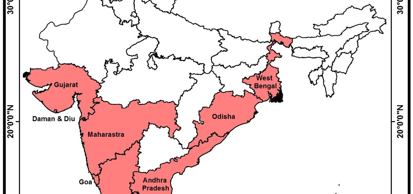
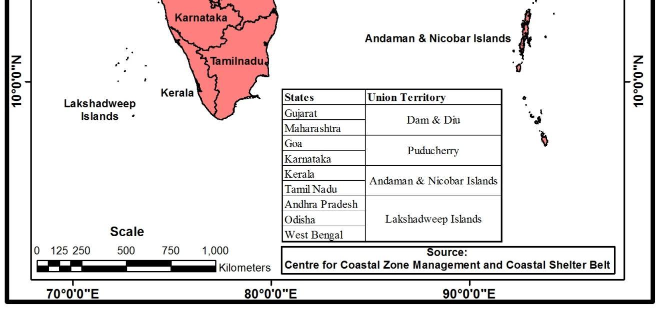
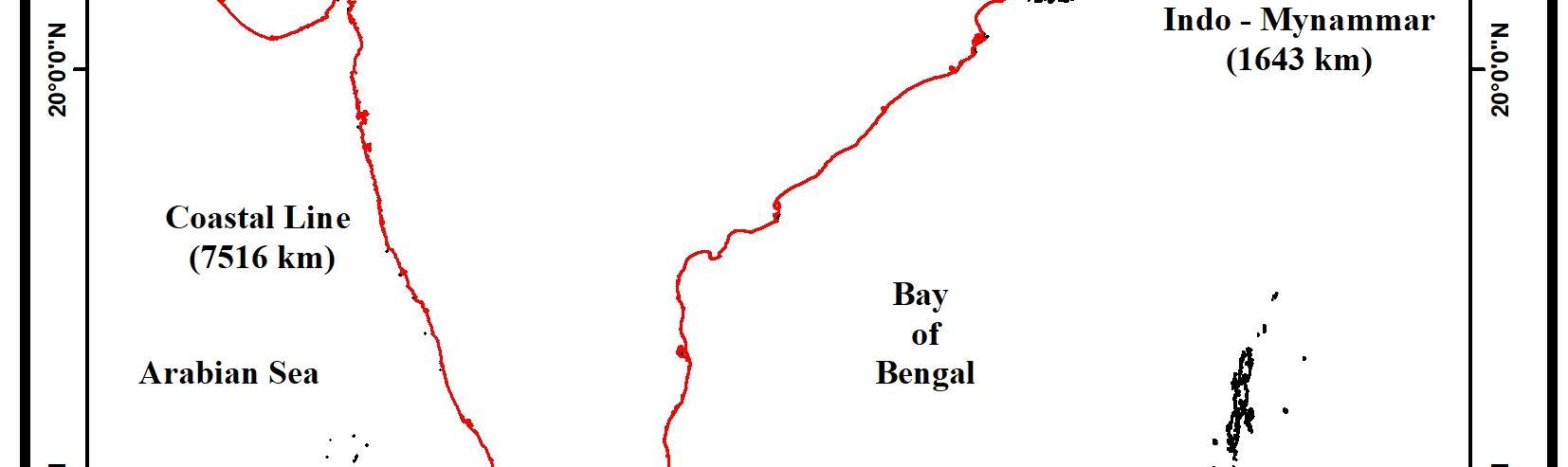
India’s coasts have always been vulnerable to criminals and anti national activities. Numerous cases of the smuggling of goods, gold, narcotics, explosives, arms, and ammunition as well as the infiltration of terrorists into the country through these coasts have been reported over the years. The smuggling of explosives through the Raigad coast in Maharashtra and Tamilnadu and their use in the 1991 Rajiv Gandhi Assassination by LTTE, 1993 serial blasts in Mumbai, and the infiltration of the ten Pakistani terrorists through the sea route who carried out the multiple coordinated attacks in Mumbai on 26th Nov 2008, are the most glaring examples of how vulnerable the country’s coasts are (Pushpita Das, 2013). Terrorist activities have become multidimensional, with organizations acquiring air, water, cyber, and land attack capabilities, and tactics. Traditionally, incapability and incapacity have largely hindered most terrorist groups from sea based attacks. The geographical location, the maritime tradition of the state, and unstable government are some of the factors that lead organizations to opt for sea based attacks, which in turn can have disastrous sequences ranging from disrupting the livelihoods of the seafarers to disrupting maritime supply chains, which in turn, affects the global economy (Aishwarya R J., 2021). Maritime terrorism is defined as “the undertaking of terrorist acts and activities within the maritime environment, using or against vessels or fixed platforms at sea or use of coastal landforms to enter in mainland or personnel, against coastal facilities or settlements, including tourist resorts, port areas, and port towns or cities” (Peter Chalk, 2008). India is a nation with an enormous stretch of coastline with various geomorphological landforms, providing easy access to the interiors of the country (Rohit Honawar.,2005). Since terrorist organizations have access to marine capabilities, the Indian government must implement adequate safeguards to prevent untoward Indiaincidents.has 7,516 kilometers long coastline which includes 5,422 kilometers of coastline on the mainland and 2,094 kilometers of coastline bordering around 1382 islands (Chandrasekar V, 2021., Sanil Kumar V et al., 2006). The peninsular coast of India is shaped by the Bay of Bengal in the east, the Indian Ocean in the south, and the Arabian Sea in the west. It is spread over nine states and four union territories: Gujarat, Daman, Diu, Maharashtra, Goa, Karnataka, Kerala, Tamil Nadu, Puducherry, Andhra Pradesh, Odisha, and West Bengal. There are two island groups: Lakshadweep and Minicoy in the Arabian Sea and Andaman and Nicobar in the Bay of Bengal (Annual Report 2020 2021, Ministry of Home Affairs, Government of India, 2021).
Maritime Terrorism, Coastal India, Weak Strategic Points, Geomorphological Landforms I. INTRODUCTION

The coastline on the Southeastern part of the Indian Subcontinent begins from the Coromandel Coast or Cholamandalam along the Bay of Bengal through the Utkala Kalinga region and extends until the easternmost Corner of the shoreline near the Sundarbans in Coastal East India. There are many beaches and springs here, as well as beautiful seas and oceans like the Arabian Sea.
973.7 Karnataka 280
The dense mangrove forest provides refuge to infiltrators during low tide, and numerous islands and sandbars dot the coastline, providing the ideal hideaways for infiltrators and their contraband. Boats can easily land and disappear in stealth and avoid detection by taking advantage of the topography. External challenges emanating from across the border, which include illegal migration, infiltration, terrorism, and smuggling, aggravate the internal security problem. Serial blasts in March 1993 and terrorist attacks of November 2008 in Mumbai happened because of poorly guarded maritime borders, on these occasions, terrorists and criminals entered India through the sea route (Pushpita Das, 2013
157.5
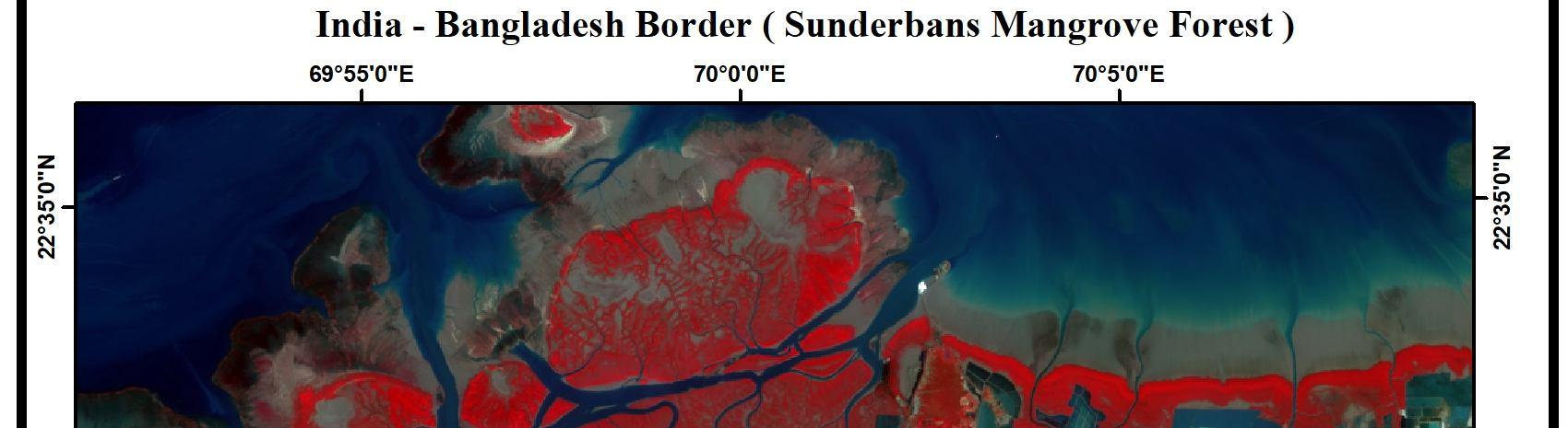
The creeks and mangrove forests along the coasts of Gujarat and West Bengal’s Sundarbans’ are the main preferred routes for smuggling and infiltration. These creeks create a maze of channels, which weave in and out of international borders. These terrains make the border extremely porous to smuggling and infiltration
30.6 Kerala 160.5 Tamil
906.9 Lakshadweep Islands 132 Andaman
Km Gujarat 1214.7 West
652.6 Odisha 476.4 Goa
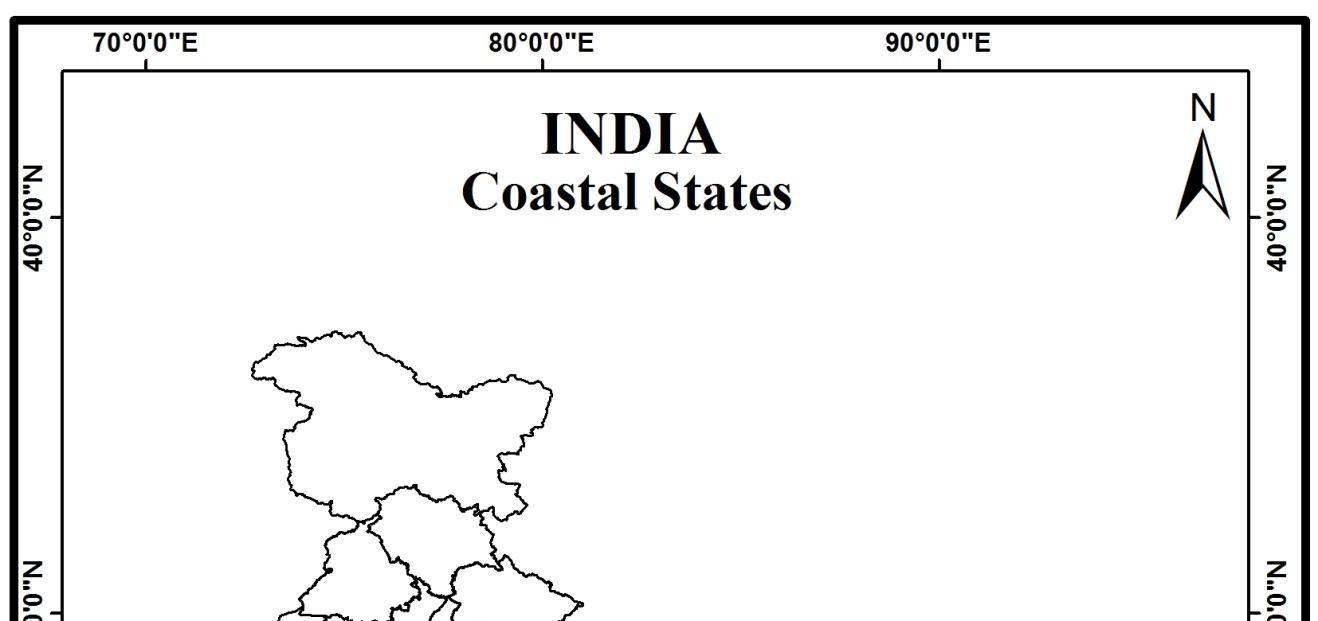
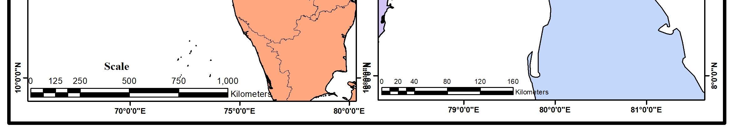
Coastal India (Fig.No.1) is a geo cultural region in the Indian subcontinent that spans the entire coastline of India (7516.6 km; Mainland: 5422.6 km, Island Territories: 2094 km). Coastal India spans from the southwest Indian coastline along the Arabian sea from the coastline of the Gulf of Kutch in its westernmost corner and stretches across the Gulf of Khambhat and through the Salsette Island of Mumbai along the Konkan and southwards across the Raigad district region and through Kanara and further down through Mangalore and along the Malabar through Cape Comorin in the southernmost region of South India
1962
Shoreline Length
International Journal for Research in Applied Science & Engineering Technology (IJRASET) ISSN: 2321 9653; IC Value: 45.98; SJ Impact Factor: 7.538 Volume 10 Issue VII July 2022 Available at www.ijraset.com 4669©IJRASET: All Rights are Reserved | SJ Impact Factor 7.538 | ISRA Journal Impact Factor 7.894 | India’s coasts are characterized by a diverse range of topography which includes creeks, small bays, backwaters, rivulets, lagoons, estuaries, swamps, mudflats, hills, rocky outcrops, sandbars, beaches, and small islands. The river channel and water bodies deep inside the coasts and low surveillance make the shoreline highly indented. These coastal features approach to the mainland are often poorly guarded or remain unguarded due to their remoteness, thereby providing ideal spots for the clandestine landings of explosives, arms, and other contraband by smugglers as well as infiltration by terrorists (Annual Report 2011 2012, MHA, 2012).
Table. No.1 of Coastal States. Coast Coast Bengal Maharashtra (with Daman & Diu) 569.7 Pradesh Puducherry Nadu & Nicobar Islands
II. STUDY AREA
Andhra
While some steps like Operation Swan were undertaken to patrol coasts off Mumbai in the wake of the March 1993 terrorist attacks, concrete measures to secure the coasts had to await the terrorist attack of November 2008. The Mumbai terrorist attacks of 2008, when ten terrorists from Pakistan entered Mumbai through a sea route from Karachi by hijacking an Indian fishing trawler, demonstrated that coastal borders are vulnerable to infiltration (MHA, 2008).
Km Eastern
Western
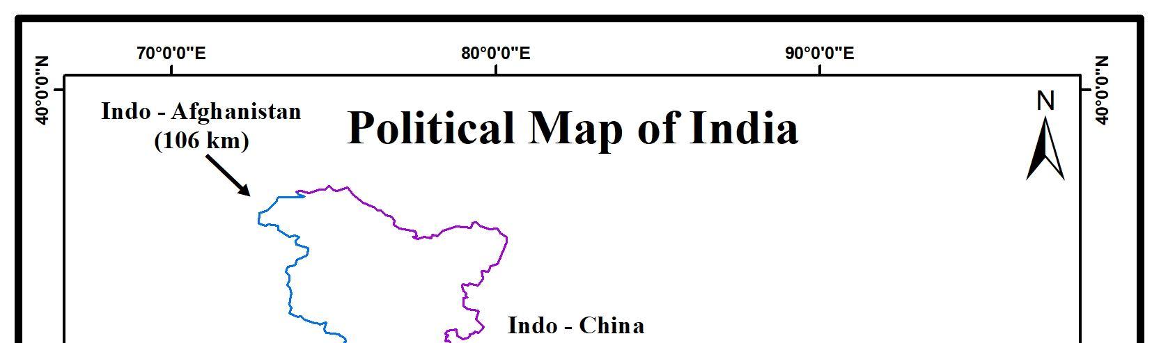
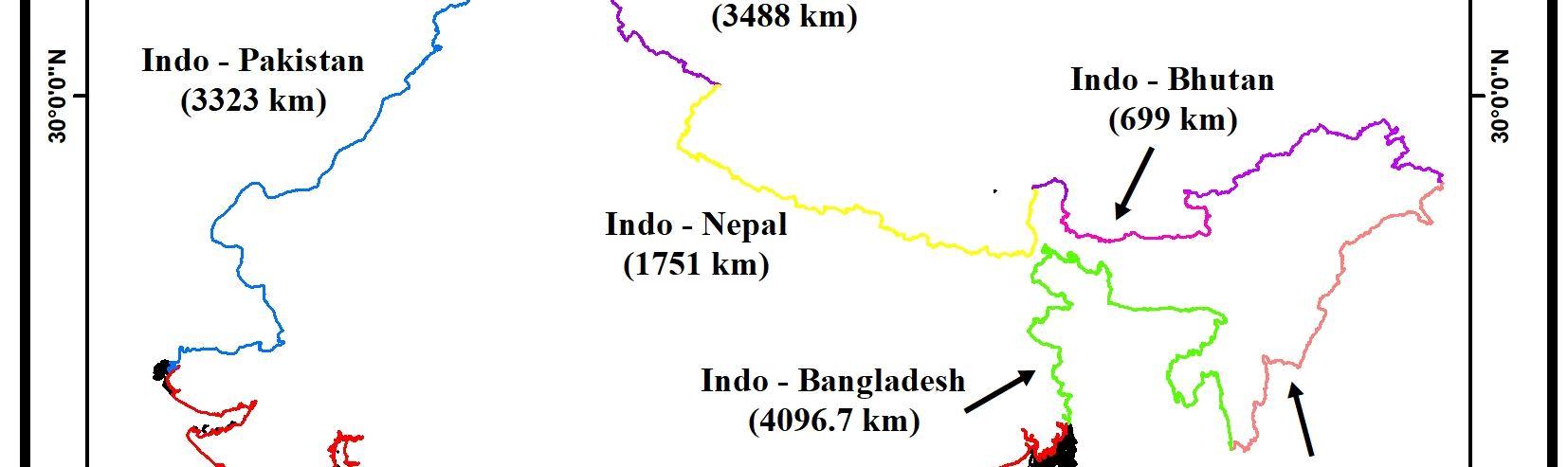
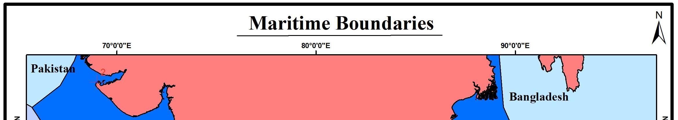
An international boundary (Fig.No.2) depicts the separation of two countries. For example, the India Pakistan border separates India and Pakistan with a 3323 km long international border. An international model line divides and marks the territorial limits between the two countries. India has 15106.7 km long land borders which run through 18 states and 92 districts including the union territories. India shares international land borders with 7 different countries. The seven countries that share international borders with India are China, Bangladesh, Afghanistan, Bhutan, Myanmar, Pakistan, and Nepal. It shares maritime borders with Pakistan, Sri Lanka, Indonesia, and the Maldives.
Figure. No.1 Coastal States of India III. INTERNATIONAL BOUNDARIES OF INDIA
International Journal for Research in Applied Science & Engineering Technology (IJRASET) ISSN: 2321 9653; IC Value: 45.98; SJ Impact Factor: 7.538 Volume 10 Issue VII July 2022 Available at www.ijraset.com 4670©IJRASET: All Rights are Reserved | SJ Impact Factor 7.538 | ISRA Journal Impact Factor 7.894 |
India Pakistan land border is 3233 km. The border touches Jammu & Kashmir, Punjab, Rajasthan, and Gujarat. India and China's border is 3488 km long. The border touches Jammu and Kashmir, Himachal Pradesh, Uttarakhand, Arunachal Pradesh, and Sikkim. India Nepal border is 1770 km. The border touches Bihar, Uttarakhand, Uttar Pradesh, West Bengal, and Sikkim. India and Bhutan’s border is 699 km. The border touches Arunachal Pradesh, Sikkim, Assam, and West Bengal. India and Myanmar’s border is 1643 km. The border touches Arunachal Pradesh, Nagaland, Manipur, and Mizoram. India and Bangladesh’s border is 4156 km and share border touches with West Bengal, Assam, Meghalaya, Tripura, and Mizoram. India and Afghanistan’s border is 106 km and shares a boundary only with Jammu and Kashmir (Elisabeth Leake, 2021).
International Journal for Research in Applied Science & Engineering Technology (IJRASET) ISSN: 2321 9653; IC Value: 45.98; SJ Impact Factor: 7.538 Volume 10 Issue VII July 2022 Available at www.ijraset.com 4671©IJRASET: All Rights are Reserved | SJ Impact Factor 7.538 | ISRA Journal Impact Factor 7.894 |
Figure. No.2 India and International Boundaries

A. West Coast of India Arabian Sea
International Journal for Research in Applied Science & Engineering Technology (IJRASET) ISSN: 2321 9653; IC Value: 45.98; SJ Impact Factor: 7.538 Volume 10 Issue VII July 2022 Available at www.ijraset.com 4672©IJRASET: All Rights are Reserved | SJ Impact Factor 7.538 | ISRA Journal Impact Factor 7.894 | IV. MARITIME BOUNDARIES OF INDIA
V. GEOMORPHOLOGICAL LANDFORMS IN COASTAL INDIA
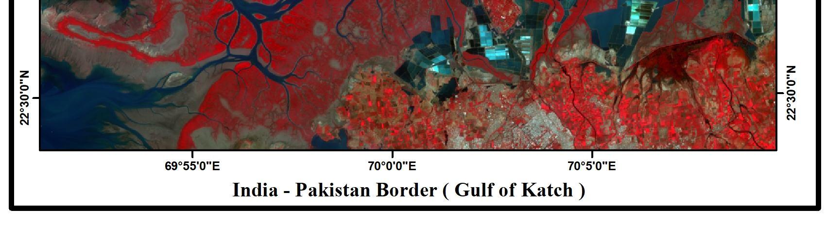
The landforms along the Arabian Sea and Bay of Bengal coasts display geomorphological characteristic variations, which are briefly described below: 1) Kachchh: A large saline desert, known as the Rann of Kachchh, is the most prominent feature in this sector. Coral reefs occur in the Gulf of Kachchh, and mangroves are present around Kori Creek. Sandy beaches and dunes are present along the northern coastline of the Gulf, whereas the southern coastline is dominated by mudflats. Along the north coast, shore platforms development of tertiary conglomerates, and longitudinal dunes are some of the salient features (Ranadhir Mukhopadhyay and S. M. Karisiddaiah, 2014)
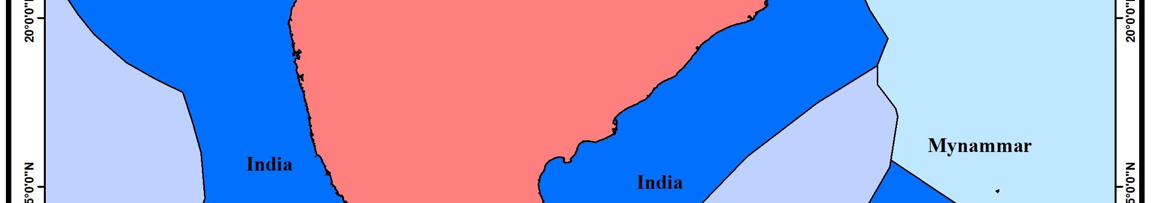
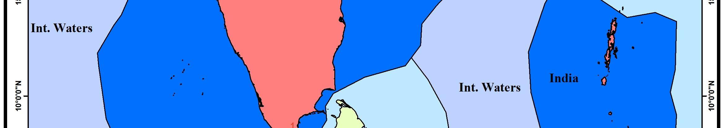
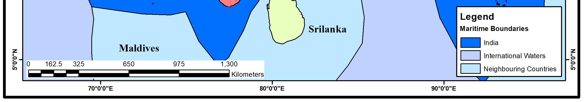
India’s maritime boundaries (Fig.No.3) necessitate delimitation with seven states on adjacent and opposite coasts of Pakistan, Maldives, Sri Lanka, Indonesia, Thailand, Myanmar, and Bangladesh The Indian coastline (including island territories) of 7,516.5 km is the 15th longest in the world, with Canada (90,889 km) and Indonesia (54,705 km) possessing the longest coasts. Since the 1970s, virtually India’s maritime boundaries have been demarcated due to political and diplomatic efforts. But the exceptions primarily remain those with Pakistan and Bangladesh (Rahul Roy Chaudhury, 1999)
Figure. No.3 India’s Maritime Boundaries
6) Lakshadweep Islands: This group of over 27 coral islands is associated with the north south aligned submarine Lakshadweep Chagos Ridge in the Arabian Sea. Apart from coral reefs and atolls, lagoons and beaches are other distinctive features that attract many tourists. The archipelago experienced severe coral mortality and bleaching in 1998, resulting in the reduction of live coral cover to < 10%. The severely damaged Kadmat and Agatti atolls are showing good recovery of live coral cover up to ~20% after the several steps taken by the environmentalist (Ranadhir Mukhopadhyay and S. M. Karisiddaiah, 2014).
5) Malabar: The Malabar Coast in Kerala is distinguished by a chain of brackish lagoons and lakes lying parallel to the coast. The backwaters were formed by the action of waves, and currents, creating low barrier islands across the mouths of the many rivers flowing from the Western Ghats. Cliffe shorelines developed in Neogene sediments, laterites, and crystalline rocks are observed at several places, such as near Kovalam, and Varkala, especially between Vettor and Tangasseri. Wave cut platforms and stacks have been reported from Kannur, Kollam, Quilandy, and Thalassery (Narayana Chinna, 2006).
1) Coromandal: The Gulf of Mannar is endowed with three marine ecosystems the corals, sea grass beds, and mangroves with swampy regions surrounded by highly productive fringing and patchy coral reefs (Table no. 2). Rich coral reefs also occur in Palk Bay. Long Marina Beach in Chennai, coastal dunes along the Mahabalipuram sector, unusually straight Kaveri Delta, and the Pulicat Lagoon are some of the noteworthy features along this coastline. Beach rocks have been reported from Rameswaram and Mandapam, and sea caves, wave cut platforms, and marine terraces are at Mandapam and Tiruchendur. The red (Teri) sand in Tamil Nadu consists of economically viable placer minerals, including ilmenite, zircon, and sillimanite. The entire Coromandel coast was impacted severely by the December 2004 tsunami (A. K. Kumaraguru, 2008)
Sanctuary is one of the most extensive mangrove forests outside the Sundarbans, and the Chilka Lake is the largest brackish water coastal lagoon in the subcontinent. Several strandlines have been identified along the Mahanadi Delta. The Odisha coast is frequently affected by coastal flooding and high storm surges associated with Bay of Bengal depressions and cyclones (Smita Priyadarsini Rout, 2018., Srinivasan Ramasamy, 2016).
2) Saurashtra: Bioclastic carbonate deposits (miliolite limestone) of the late Quaternary age characterize land sea interaction in the form of cliffs, marine terraces, wave cut platforms, and marine notches along the Saurashtra coast. These features have been used to ascertain the magnitude of sea level changes during the Late Quaternary. Cliffs and shore platforms are prominently seen between Varvel, Diu, and beyond Jafrabad. Sandy beaches occur as the continuous strip between Dwarka and Diu (Nilesh Bhatt, 2003., Ranadhir Mukhopadhyay and S. M. Karisiddaiah, 2014)
3) Odisha: Much of this sector's 480 km coastline consists of long sandy beaches and muddy shorelines. The coastal plain of Odisha is called the "hex deltaic region" formed by six rivers Subarnarekha, Budhabalanga, Baitarani, Brahmani, Mahanadi, and TheRushikulya.Bhitarkanika
2) Andhra Pradesh: The 300 km long Andhra Pradesh coast is dominated by lengthy, extensive beaches of the Godavari Krishna Delta complex. Rocky sea cliffs, shore platforms, and sea caves are present along the northern Andhra Pradesh coast, particularly between Revu Polavaram and Vishakhapatnam. A prominent sand spit (17 km long) enclosing Kakinada Bay is one of the exciting features along the Godavari Delta coast. More than four strandlines have been identified in the delta area (KV Suryanhagavan, 2013., K Kameshwara, (2012).
B. Eastern Coast of India Bay of Bengal
International Journal for Research in Applied Science & Engineering Technology (IJRASET) ISSN: 2321 9653; IC Value: 45.98; SJ Impact Factor: 7.538 Volume 10 Issue VII July 2022 Available at www.ijraset.com 4673©IJRASET: All Rights are Reserved | SJ Impact Factor 7.538 | ISRA Journal Impact Factor 7.894 |
3) Konkan: The Konkan coastline is dominantly rocky, with rock promontories, intervening sandy pocket beaches, and intertidal mudflats. Sediments are predominantly derived from Deccan Trap basalts. This stretch includes estuaries, headlands, sea cliffs, shore platforms, pocket beaches, tidal flats, mangroves, and spits. Large patches of mangroves occur predominantly along the Thane Creek and Malvan coast. Well developed wave cut platforms are present at Harihareshwar and Murud Janjira, and sea caves can be seen around Ratnagiri. The Malvan Marine Sanctuary is rich in corals, seaweeds, and mangroves. Beach rocks (karal) and aeolianites have been reported from several places along the Konkan and Goa coasts (Pramod T Hanamgond, 2008)
4) Goa Kannada: Goa's coastline is a scenic combination of bays and headlands broken by large estuaries of the Mandovi and Zuari rivers. Of the bays, the Baga, Calangute, and Colva are long curved stretches of white beach sands and palm fringes. The Uttar (north) Kannada coast is rockier than that of Dakshin (south) Kannada. Netravati, Kalinadi, Sharavati, etc., rivers have prominent estuaries, and Kundapur Estuary is the largest estuarine complex. Sand bars are present in the mouths of most of the estuaries. Wave cut platform in laterite at Dona Paula, the Cliffe coastline around Someshwar, columnar basalt at St. Mary Island near Udupi, and crescent shaped beaches near Gokarna, are some of the noteworthy features in this stretch (H. Gowda, 1995., Ranadhir Mukhopadhyay and S. M. Karisiddaiah, 2014)
Sundarbans West Bengal Quaternary deltaic and coastal deposits
Odisha Odisha West Bengal Quaternary deltaic and deposits,coastal/marinelaterite E, P, NR Large deltas, long beaches, spits, dunes, beach and dune ridges, chenniers, mangroves
International Journal for Research in Applied Science & Engineering Technology (IJRASET) ISSN: 2321 9653; IC Value: 45.98; SJ Impact Factor: 7.538 Volume 10 Issue VII July 2022 Available at www.ijraset.com 4674©IJRASET: All Rights are Reserved | SJ Impact Factor 7.538 | ISRA Journal Impact Factor 7.894 | Table. No.2: Coastal geomorphic divisions and associated landforms divisionsGeomorphic Name territorystates/unionof Dominant lithology typeCoastline Major landforms and features Kachchh Gujarat Miocene sandstones and limestone, Tertiary formations, and Quaternary deposits S, NR Large saline marshland, estuaries, cliffs and beaches, coastal sand dunes, mangroves Saurashtra Gujarat Deccan QuaternaryPlioceneMiliolites,Traps,Mioformations,sediments S, R Estuaries, cliffs, beaches, spits, coastal sand dunes, mudflats, raised marine benches Konkan (and south Gujarat) GujaratMaharashtra Deccan Traps, laterites, Quaternary sediments S, R Estuaries, cliffs, wave cut platforms, pocket beaches, coastal sand dunes, spits, tombolo Kannada Goa Karnataka Goa Peninsular sedimentslaterites,Metasediment,Gneiss,Quaternary S, R Estuaries, cliffs, wave cut platforms and beaches, spits, coastal sand dunes, tombolo
E, P, NR Large delta, thick mangrove forests, tidal channels, deltaic islands, beaches, dunes
Coromandal Tamil PuducherryNadu Charnockites, gneisses, granite, QuaternaryPliocenesandstone,CuddaloreMio,andsediments
basalt,limestoneconglomerates,Sandstones,andshale,and Archipelago, islands and islets, cliffs, caves, beaches, sand dunes, fringing coral reefs, mangroves, lagoons
Andhra PradeshAndhra depositsdeltaickhondalite,Charnockites,Quaternary,andcoastal E, P, R, NR Large deltas, long beaches, spits, dunes, beach and dune ridges, mangroves, red sediments, sea cliffs, shore platforms
IslandsLakshadweep Lakshadweep Corals Archipelago, coral reefs and atolls, submerged coral banks, beaches, lagoons
S Submerged; E Emerged; P Prograding, R Dominantly rocky; NR Dominantly non rocky Compiled by Vishwas S. Kale from Vaidyanathan (1987, 1991), SAC (2012), Ranadhir Mukhopadhyay (2014)
E, P, NR Large deltas, long beaches, spits, mangroves, coral reefs, dunes, chenniers, beach and dune ridges, red sediments (Teri)
Malabar Kerala lateritesQuaternaryNeogenePeninsularCharnockites,gneiss,andsediments, S, NR, R Estuaries, lagoon barrier complexes, spits, beaches, coastal sand dunes, cliffs
Andaman and IslandsNicobar Andaman and Nicobar
5) Andaman and Nicobar Islands: This archipelago, consisting of over 570 islands and islets, is characterized by ophiolite, epiclastic/volcaniclastic sandstones, tuffs, bioclastic limestones, and patchy reefs of late Cretaceous to Pleistocene age. Sandy beaches, mangrove lined creeks, tidal inlets and bays, fringing reefs, and rocky shores are some of the salient features of the islands. Narcondam and Barren Islands are two volcanic islands in the Andaman Sea. The sediment based coastal features (beaches, tidal flats), mangroves, and coral reefs experienced intense damage during the December 2004 tsunami (P. C. Bandopadhyay, 2014).
Pennar 1,470 dominatedWave Palaeo channels, spits, lagoons, levees, beach ridges, tidal flats, Kaveri 8,770 dominatedWave Coleroon, Kaveri, Arasalar, Vettar Palaeo channels, mangrove swamps
International Journal for Research in Applied Science & Engineering Technology (IJRASET) ISSN: 2321 9653; IC Value: 45.98; SJ Impact Factor: 7.538 Volume 10 Issue VII July 2022 Available at www.ijraset.com 4675©IJRASET: All Rights are Reserved | SJ Impact Factor 7.538 | ISRA Journal Impact Factor 7.894 |
Table. No.3 Major deltas of India
BrahmaputraGanga 65,000 dominatedTide Gorai Madhumati, Jalangi, Methaabanga, Bhairab, Kobadak, Arial Khan, Hoogly Tidal channels, tidal islands, mudflats, large mangrove swamps, palaeo channels
Mahanadi 9,500 dominatedWave Mahanadi, Devi, Bhargavi Beaches, palaeo channels, mangrove swamps, beach ridges, strandlines
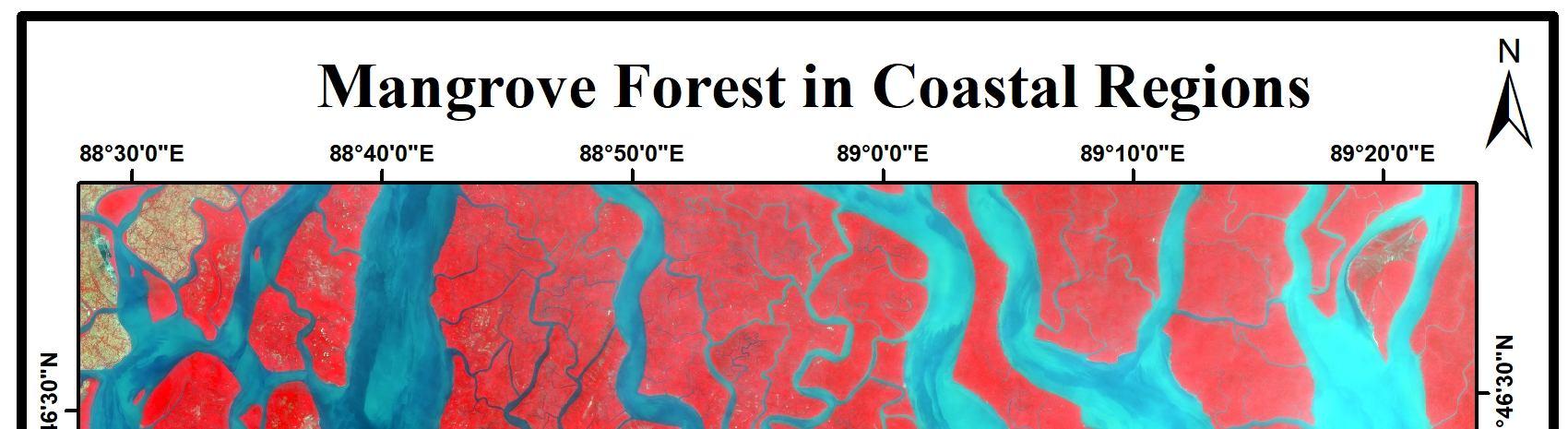
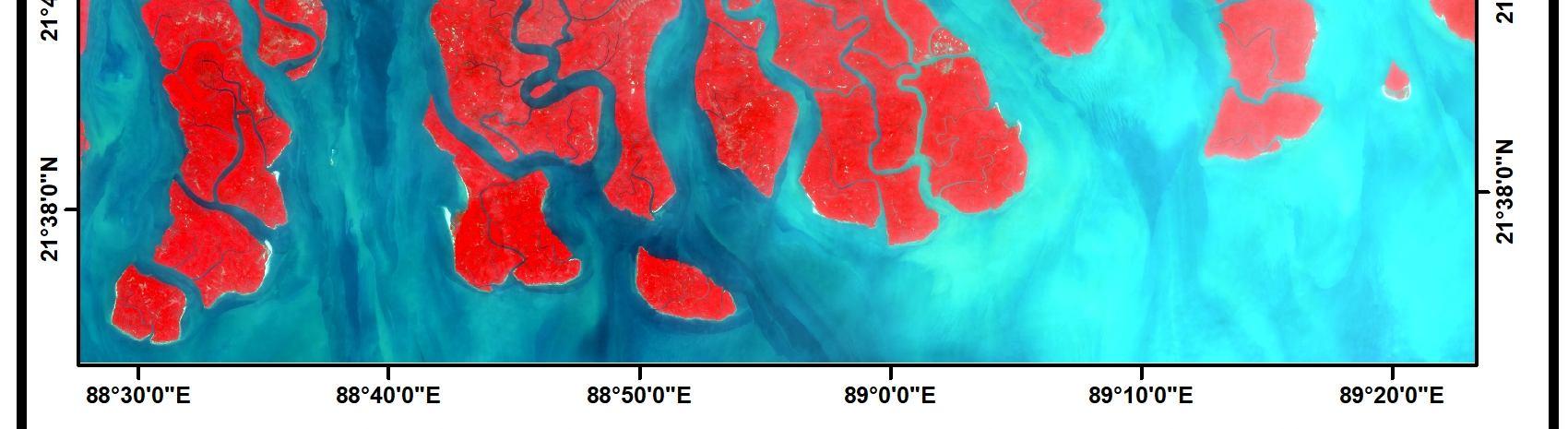
Figure. No.4 Mangrove Forest in Coastal India Delta Area in km2 Delta type Principal distributaries Major geomorphic features
Godavari 6,300 dominatedWave Vasishta, GostanadiGautami, Palaeo channels, beach ridges, mangrove swamps, Kakinada spit, delta lobes, strandlines Krishna 5,500 dominatedRiver Medimurru,Gulumuttapaya,Krishna Palaeochannel, tidal islands, mangrove swamps, levees, five delta lobes, strandlines
4) Sundarbans: The Sundarbans tidal delta with an area of 10,000 km2, forms a part of the world’s largest delta fed by Ganga Brahmaputra with several tidal inlets, creeks, and deltaic islands (Fig.No.4). The tidal channels separating the numerous islands are provided by the backwaters of the Bay of Bengal. The tidal delta is very swampy, with extensive mangroves. Significant features include mud flats, mangrove swamps, dune complexes, estuaries, creeks, beaches, and islands (Dipnarayan Ganguly, 2006).
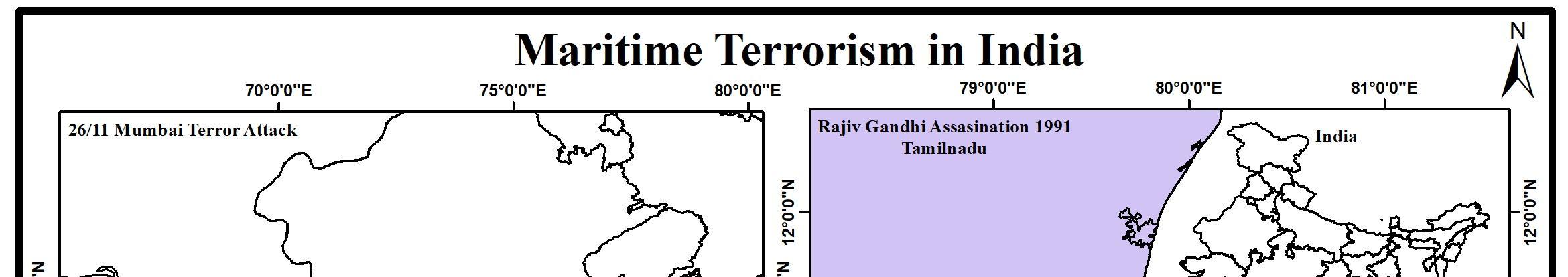
The assassination of Rajiv Gandhi, former Prime Minister of India, occurred due to a suicide bombing in Sriperumbudur, Tamil Nadu, India, on 21st May 1991 (Fig.No.5). At least 14 others, in addition to Rajiv Gandhi, were killed in this incident. Based on the Investigation, in September 1990, a boat packed with Tamil civilians fleeing the war in Sri Lanka’s northeast reached the Tamil Nadu coastal town of Rameshwaram. Two men and a woman from the group met Indian officials and registered as refugees but moved on to Chennai, saying they had friends in the city. A few days later, another boat of Tamil refugees also reached the Tamil Nadu coast. As in the first instance, two men and a woman registered as refugees and said they would also prefer to live with friends in Chennai (Michael Roberts, 2010., B Raman, 2018)
The Maritime and land borders between India and Pakistan are highly surveillance boundaries Less focus has been given to the maritime issues between both countries, including Sir Creek and its effect on the delimitation of the interstate maritime boundary.
Figure. No.5 Maritime Attacks in Coastal India
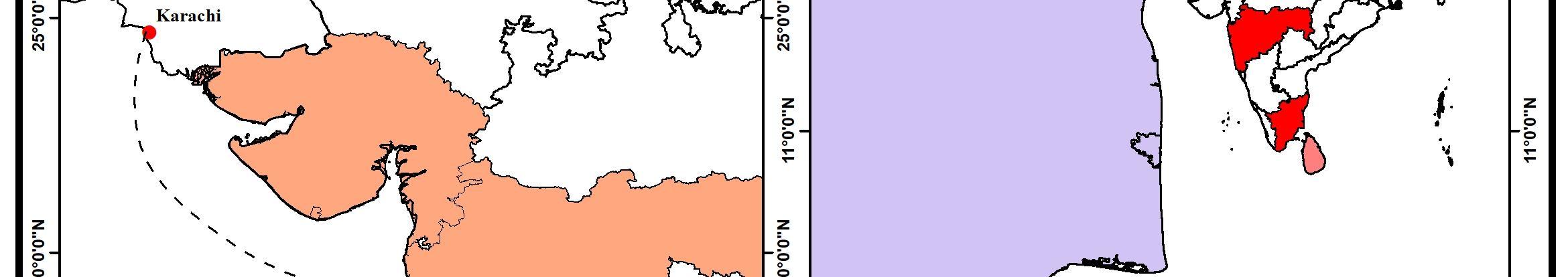
The 2008 Mumbai attacks, also referred to as 26/11 (Fig.No.5), were a series of terrorist attacks that took place in November 2008, when ten members of Lashkar e Taiba, an Islamist terrorist organization from Pakistan, carried out 12 coordinated shootings and bombing attacks lasting four days across Mumbai. According to investigations, The terrorist stayed and was trained by the Lashkar e Taiba in a safe house at Azizabad in Karachi before starting their attack. Then they traveled by the sea from Karachi, Pakistan, across the Arabian Sea and hijacked an Indian fishing trawler "Kuber" and, the terrorist entered Mumbai on a rubber dinghy Prem Mahadevan, 2019., Rhys Machold, 2017., Saroj Kumar Rath, 2010)
The Maritime borders between India and Sri Lanka are mainly covered by shallow coastal areas which is one of the weakest strategical regions which allows infiltrations to the mainland. Since the shallow coastal structure doesn’t support the movement of boats new to the shore, the infiltrators reach the land, settle and get assistance from others for arms and ammunition to execute the mission. This is the way through which the LTTE was able to succeed in their assassination mission in Sriperumbathur, Tamilnadu.
The Gujarat and Mumbai regions are covered by deep coastal areas which influences the terrorists to reach the coast with arms and ammunition. This made a strategically weaker region that allows infiltrations to the shore and execute their plan easily So, the region of Mumbai become an easy target for the terrorist in past events.
International Journal for Research in Applied Science & Engineering Technology (IJRASET) ISSN: 2321 9653; IC Value: 45.98; SJ Impact Factor: 7.538 Volume 10 Issue VII July 2022 Available at www.ijraset.com 4676©IJRASET: All Rights are Reserved | SJ Impact Factor 7.538 | ISRA Journal Impact Factor 7.894 | VI. MARITIME ATTACKS IN COASTAL INDIA
B. Rajiv Gandhi Assassination, 1991
A. 26/11 Mumbai Attack, 2008

[11] Karuturi Venkata Suryabhagavan, J Seetharamaiah (2013). Remote sensing based delineation of depositional landforms of Modern Penner Delta in Andhra Pradesh, India. International Journal of Earth Sciences and Engineering Vol 6(5):957 963.
[13] Ministry of Defence. (2013). Technology Perspective and Capability Roadmap. April 2013.
[12] Ministry of Defence (2010). Annual Report 2009 2010.
[3] Annual Report 2011 2012, Ministry of Home Affairs, Government of India, 2021 [4] Annual Report 2020 2021, Ministry of Home Affairs, Government of India, 2021 [5] B Raman. (2018). The Assassination of Rajiv Gandhi. Indian Defence Review.
[21] Ranadhir Mukhopadhyay and S. M. Karisiddaiah, (2014). The Indian Coastline: Processes and Landforms. Chapter 8. Landscapes and Landforms of India
[6] Chandrasekar V. (2021). Long Term Impacts of Coastal Dynamics on the Livelihood of Coastal Taluks in Tiruvallur District, Tamilnadu, India. Shodhganga.
International Journal for Research in Applied Science & Engineering Technology (IJRASET) ISSN: 2321 9653; IC Value: 45.98; SJ Impact Factor: 7.538 Volume 10 Issue VII July 2022 Available at www.ijraset.com 4677©IJRASET: All Rights are Reserved | SJ Impact Factor 7.538 | ISRA Journal Impact Factor 7.894 |
VIII. REFERENCES
[20] R. Srinivasan1, D. C. Nayak1, S. K. Singh, and S. K. Reza (2016). Landform Soils Relationship in Coastal Odisha Major Problems and Management. Popular Kheti. Volume 4, Issue 2 (April June), 2016.
[22] Rhys Machold (2017). Militarising Mumbai? The ‘Politics’ of Response. Contexto Internacional. vol. 39(3) Sep/Dec 2017.
[28] Vaidyanadhan R (1987) (ed) Coastal geomorphology of India. Journal Geological Society of India, special volume 29, Bangalore
[2] Aishwarya R J. (2021). Maritime Terrorism in the Indian Ocean Region. Electronic Journal of Social and Strategic Studies. Volume 2 Issue 3.
Even though only a few maritime terrorist attacks occurred due to a lack of capability and other factors, they are still common. The implications of such an attack can be enormous, having an individual, state, and global impact. The Indian Ocean region is vulnerable to maritime terrorism due to many factors, and it must address the challenges by combating terrorism at sea. This region faces challenges in combating terrorism due to a lack of great power, unknown weak strategical points, highly modernized technological expertise to collect data, and political and economic instability. Identifying and developing the capabilities required by the Armed Forces to support the decisive edge will be the cornerstone of future defense planning. The existing and emerging global and regional security scenario requires the Armed Forces to maintain a high degree of preparedness across the entire spectrum of conflict. The tremendous advancement in technology and the rapidly evolving strategy in the security environment require well thought capability maps adequately supported by technology to achieve optimum combat preparedness. Achieving self reliance in providing the desired capability involves quality as well as quantity. Capacity building is, therefore, an equally enormous challenge. Achieving capability and capacity will be possible only with the proper understanding of landforms and ensuring that all stakeholders understand a clear and coherent way ahead to achieve optimum utilization of scarce resources.
VII. CONCLUSION
[17] Pramod T Hanamgond Debashis Mitra (2008). Evolution of Malvan Coast, Konkan, West Coast of India A Case Study Using Remote Sensing Data. journal of Coastal Research. [18] Prem Mahadevan. (2019). A Decade on from the 2008 Mumbai Attack: Reviewing the question of state sponsorship. The International Centre for Counter Terrorism. [19] Pushpita Das (2013). Coastal Security: The Indian Experience. Institute for Defence Studies and Analyses. September 2013.
[10] K Kameshwara, (2012). Geomorphology of Southern Coastal Plain of Andhra Pradesh: Process, Landforms, and Hazards. Journal of Indian Geomorphology. Vol 1 2012.
[24] SAC (2012) Coastal zones of India. Space Applications Centre, Ahmedabad, p 597
[1] A. K. Kumaraguru, V. Edwin Joseph, M. Rajee, T. Balasubramanian (2008). Palk Bay Information and Bibliography. Centre for Marine and Coastal Studies. Environmental Information System Centre (ENVIS) Centre of Advanced Study in Marine Biology
[26] Smita Priyadarsini Rout., Palanivel K., Kumanan C.J., Ramesh Kumar K and Sudhakar, (2018). Geospatial Technology Based Detailed Mapping Of Geomorphic Landformsand Understanding of Migratory Pattern of Rivers in A Part of Mahanadidelta in Coastal Odisha, India. International Journal of Scientific Research Vol.9,(Issue 3(D).
[7] Dipnarayan Ganguly, Anirban Mukhopadhyay, R.K. Pandey, Debashis Mitra (2006). Geomorphological study of Sundarban Deltaic Estuary. Journal of the Indian Society of Remote Sensing. 34(4):432 435.
[23] Rohit Honawar. (2005). Maritime Terrorism or Piracy Is India Prepared? The Institute of Peace and Conflict Studies (IPCS).
[27] V. Sanil Kumar*, K. C. Pathak, P. Pednekar, N. S. N. Raju and R. Gowthaman (2006). Coastal processes along the Indian coastline. Current Science, Vol. 91, No. 4, 25 August 2006.
[8] Elisabeth Leake. (2021). Where National and International Meet: Borders and Border Regions in Postcolonial India. The International History Review https://doi.org/10.1080/07075332.2021.1900323
[14] Narayana Chinna, Priju C P (2006). Evolution of Coastal Landforms and Sedimentary Environments of the Late Quaternary Period along Central Kerala, Southwest Coast of India. Journal of Coastal Research. SI 39 [15] Nilesh Bhatt., Uday Bhonde (2003). Quaternary fluvial sequences of South Saurashtra, Western India. Quaternary carbonate deposits of Saurashtra and Kachchh, Gujarat. April 2003. [16] Peter Chalk., (2008). The Maritime Dimension of International Security. Project Air Force.
[9] Gowda, H. Honne ; Raj, K. Ganesha ; Padmavathy, A. S. ; Manikiam, B. (1995). Multidate satellite data for the study of dynamics of coastal landforms of Uttara Kannada, South India. International Journal of Remote Sensing, vol. 16, issue 14, pp. 2539 2553.
[25] Saroj Kumar Rath (2010). 26/11 Mumbai Attacks. World Affairs: The Journal of International Issues. Vol. 14, No. 4, Winter 2010 (Oct Dec).
[31] Michael Roberts (2010). Killing Rajiv Gandhi: Dhanu's sacrificial metamorphosis in death. South Asian History and Culture. Taylor & Francis. Pages 25 41
International Journal for Research in Applied Science & Engineering Technology (IJRASET) ISSN: 2321 9653; IC Value: 45.98; SJ Impact Factor: 7.538 Volume 10 Issue VII July 2022 Available at www.ijraset.com 4678©IJRASET: All Rights are Reserved | SJ Impact Factor 7.538 | ISRA Journal Impact Factor 7.894 | [29] Vaidyanadhan R (1991) (ed) Quaternary deltas of India. Memoir 22, Geological Society of India, Bangalore, 291 p [30] Rahul Roy Chaudhury (1999). Trends in the Delimitation of India’s Maritime Boundaries. Strategic Analysis: A Monthly Journal of the IDSA. January 1999 (Vol. XXII No. 10)