
10 X October 2022 https://doi.org/10.22214/ijraset.2022.47166
ISSN: 2321 9653; IC Value: 45.98; SJ Impact Factor: 7.538
Volume 10 Issue X Oct 2022 Available at www.ijraset.com

ISSN: 2321 9653; IC Value: 45.98; SJ Impact Factor: 7.538
Volume 10 Issue X Oct 2022 Available at www.ijraset.com
Shashi Kant Yadav1, Dr. Anirudh Gupta2

1M.Tech Scholar, CED, Institute of Engineering and Technology, Lucknow, India

2Assistant Professor, CED, Institute of Engineering and Technology, Lucknow, India
Abstract: Groundwater intrinsic vulnerability maps are considered a promising means for forestalling groundwater resources from contamination in recent years. With the use of a Geographic Information System (GIS) and hydro geochemical data, the DRASTIC model is used to forecast groundwater vulnerability. For which ArcGIS software is used. Lucknow, capital of Uttar Pradesh, is the study area for this study. This model is based on the seven data layers that provide the input to the modelling. It corresponds to the initials of seven layers i.e. Depth to water, net Recharge, Aquifer media, Soil media, Topography, Impact of vadose zone ,and Hydraulic Conductivity. Mal and Sarojani Nagar Block showed higher vulnerability (139 143). The results also suggested that the low, moderate, and high groundwater vulnerability zones cover around 30.35%, 45.02%, and 24.63 % of the study area, respectively. The results is validated using nitrate concentration in groundwater. The percentage of study area for nitrate concentrations <45 mg/l, 45 60 mg/l, 60 80 mg/l, and 80 110 mg/l are 55.5%, 34.5%, 9%, and ~1% respectively. The GIS technique has provided an efficient tool for assessing and analysing the vulnerability to groundwater pollution.
Keywords: Groundwater vulnerability, DRASTIC model, ArcGIS, Lucknow
Groundwater is the most important source of water supply because it is more accessible than surface water and is less susceptible to contamination For people to survive and for a nation to flourish sustainably, a clean and secure water source is essential. Water's suitability is determined by its physical, chemical, and biological characteristics, all of which may be influenced by anthropogenic and natural processes. Protecting the quality of drinking water is a difficult and important task, particularly in rapidly urbanizing regions where industrialization, untreated wastewater discharge, incorrect land use, pesticides, and excessive fertilizer usage are regular occurrences. Such activities may increase groundwater pollution potential by various types of pollutants such as pesticide residue, nitrate, etc.
Groundwater Vulnerability is the sensitivity of an aquifer system towards getting contaminated by any external perturbations. The areas with relatively higher groundwater contamination potential can easily be depicted by intrinsic vulnerability maps. The study area for this study is Lucknow district, a fast growing city, in Uttar Pradesh, India. Which is also the Capital of Uttar Pradesh. Urban land areas are becoming more vulnerable to groundwater pollution, according to studies on groundwater susceptibility. Vulnerability assessments are carried out in areas where water resources are stressed due to anthropogenic activities. The most used groundwater vulnerability assessment model is the DRASTIC model, which is based on an index approach and a GIS overlay. As one of the conventional methods for vulnerability assessment of groundwater resources, the DRASTIC method has been used in studies by many researchers in recent years. Introduced first by Aller in 1987, The DRASTIC technique decreases the impact of potential uncertainties in aquifer characteristics by using the maximum parameter of compelling aquifer features in determining vulnerability. This model is composed of seven thematic layers that must be utilized as inputs when building it. These seven parameters are Depth of water level (D), Net Recharge (R), Aquifer media (A), Soil media(S), Topography ( % Slope) (T), Impact of vadose zone (I), and Hydraulic Conductivity (C)
Monitoring the appropriateness of groundwater is crucial due to rising industrialization and urbanization. The main objective of the study is to assess the groundwater vulnerability to contamination using the DRASTIC model and formulate a spatial distribution map of the Water quality index for drinking purposes.
ISSN: 2321 9653; IC Value: 45.98; SJ Impact Factor: 7.538 Volume 10 Issue X Oct 2022 Available at www.ijraset.com
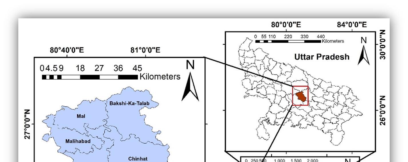
Lucknow district situated in the state of Uttar Pradesh covers an area of 2528 sq. km. The area lies between North Latitude 26° 30‟ 27° 10‟ and East Longitude 80° 30‟ 81° 13‟. The shape of the district is like an irregular quadrilateral. Administratively, Lucknow district has been divided into 5 tehsils and 8 Community Development blocks viz., Bakshi Ka Talab, Chinhat, Gosaiganj, Kakori, Mal, Malihabad, Mohanlalganj, and Sarojani Nagar. The district is the capital of Uttar Pradesh and is well connected by railways, roads, and airways. The area is covered by younger and older alluvial plains. The younger alluvial plain lies all along the Gomti River and comprises active and older flood plains. The older alluvial plain occupies higher levels than the younger alluvial plain and is marked with natural levees, palaeochannels, and meander scars. The slope in the district is generally low with a slight high gradient along the Gomti River.
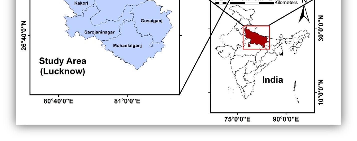
Fig. 1. Study Area (Lucknow)
A GIS based model, called DRASTIC, was established by the United States Environmental Protection Agency (USEPA) and is a typical model for evaluating groundwater vulnerability to contamination (Aller et al., 1987). The locations that were more susceptible to pollution or groundwater vulnerability were identified using this approach. The groundwater vulnerability maps are very helpful for the planning, management, and protection of groundwater. The model comprises the following seven relevant hydrogeological and terrain parameters which govern the occurrence and movement of groundwater into the system:
1) Depth to water level (D)
2) Recharge (R)
3) Aquifer media (A)
4) Soil media (S)
5) Topography (T)
6) Impact of vadose zone (I)
7) Hydraulic conductivity (C). For each of the variables, a thematic layer must be prepared. All of these variables are categorized into several classes, prioritized, and then weighted based on their relative significance to the pollution potential as per table 1. The DRASTIC index of the seven layers was calculated by the weighted sum overlay method using Eq. (1).
DRASTIC index = DrDw + RrRw + ArAw + SrSw + TrTw + IrIw + CrCw
……. (1)
ISSN: 2321 9653; IC Value: 45.98; SJ Impact Factor: 7.538 Volume 10 Issue X Oct 2022 Available at www.ijraset.com
Where D, R, A, S, T, I, and C are the above mentioned seven input parameters; r is the rating value; and w is the weight assigned to each parameter, respectively. The higher DRASTIC index indicates a higher intrinsic vulnerability to pollution.
TABLE 1. CLASSES AND RATINGS FOR DRASTIC PARAMETERS (SOURCE: ALLER ET AL. 1987)
Parameter Range Rating Weight
Depth to water table (m) 1.5 4.5 4.5 9.1 9.1 15.2 15.2 22.9 22.9 30.5 >30.5
9 7 5 3 2 1


5
Net recharge (in/year) 7 10 >10 8 9 4
Aquifer media Sand 4 9 3 Soil media Sandy loam Loam Silty loam
6 5 4
2 Topography 0 2 2 6 10 9 1
Impact of volume zone Sand and gravel 6 9 5 Hydraulic conductivity 1 4.1 4.1 12.2 1 2 3
The details of data types and their sources for preparing the input parameter maps (layers) of the DRASTIC model are provided in Table 2. ArcGIS software is used for setting up input datasets and implementing the DRASTIC model. The overall framework of the processing scheme followed in the study is shown in Fig. 2.
Depth to water table Net Recharge Aquifer Media Soil Media Topography Impact of vadose zone Hydraulic Conductivity Spatial Analysis using ArcGIS
Weighting & Rating
DRASTIC Index map Validation of DRASTIC Model with Nitrate Concentration
Fig. 2. Flow chart for assessment of groundwater vulnerability using DRASTIC model in GIS
ISSN: 2321 9653; IC Value: 45.98; SJ Impact Factor: 7.538
Volume 10 Issue X Oct 2022 Available at www.ijraset.com
Output layer Data type Source
Depth to water table (D) Water level data CGWB, Lucknow Net recharge (R) Recharge data CGWB, Lucknow Aquifer media (A) Borehole lithology CGWB, Lucknow
Soil media (S) Soil map CGWB, Lucknow
Topography (T) Digital elevation model(DEM) USGS Earth Explorer Impact of Vadose zone (I) Borehole data CGWB, Lucknow
Hydraulic Conductivity (C) Transmissivity CGWB, Lucknow
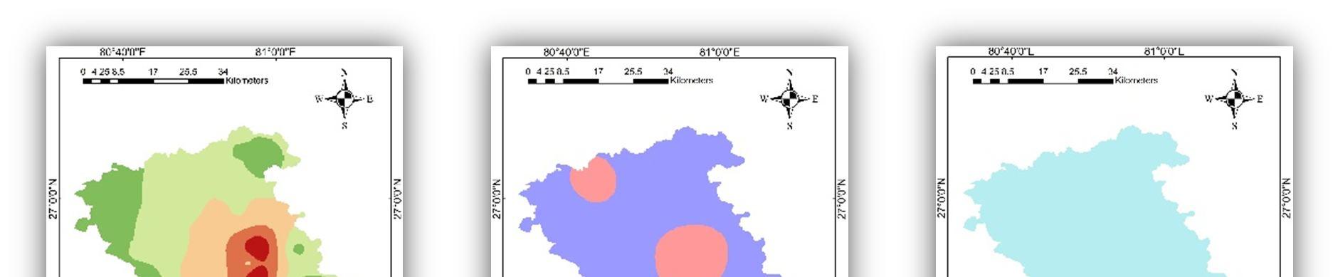
One of the most significant factors determining the thickness of the aquifer through which contaminants pass before reaching groundwater is the depth to water level. Thus the maximum weight (5) has been assigned to this parameter. The likelihood of aquifer contamination is inversely correlated with the distance from the surface to the water. Since contaminating chemicals take a very long time to reach to deeper depths, thus the possibility of aquifer contamination decreases as water depth increases. Therefore, the maximum rating of 9 has been given to lower depth and a minimum rating of 1 has been assigned to greater depth (Aller et al., 1987). The water level data were obtained from Central Ground Water Board (CGWB) and depth to water table map was prepared based on average pre monsoon and post monsoon water level data for the year 2020. The final depth to water table map as shown in Fig. 3(a) has six rating classes (1, 2, 3, 5, 7, and 9) as per Table 1. The shallowest water level (<2 mbgl) was observed at Dona (Kakori block), whereas the deepest water table of about 40 mbgl was observed at Vikas Nagar (Chinhat) of Lucknow urban area of the district.
Net recharge is a hydrological process where surface water from precipitation and artificial sources moves down to the water table (Ghosh et al., 2021) As this process moves the contaminating elements from the vadose zone to the saturated zone, it is one of the most important characteristics. There is a clear link between the volume of recharge and the potentiality of aquifer pollution. Higher recharge volume carried out more solid and liquid contaminating materials. The block wise net recharge obtained from the Central Ground Water Board (CGWB) showed that net recharge varied from 7.738 to 15.689 inch/year in the study area. According to the DRASTIC method, the net recharge was assigned a weight of ‘4’. As per the DRASTIC ratings of net recharge layer, reclassification of recharge layer was carried out. The net recharge map which is presented in Fig. 3(b), showed only two ratings of 8 and 9 (Table 1).
Aquifer media refers to the underground layers of consolidated and unconsolidated rocks. The material kinds of an aquifer, such as sand, limestone, gravel, etc., directly affect the groundwater availability and pollution of the aquifer. The probability of contamination is directly correlated with grain size. The chance of aquifer pollution will be decreased the smaller the grain size. Therefore, the finer media assigned a lower rate, and coarse media assigned a higher rate (Aller et al. 1987). The aquifer media map presented in Fig. 3(c), was generated on the basis of available borehole aquifer media data of the study area. The aquifer media of study area in Sandy and rating of 8 weight of 3 is given to it (Table 1).
ISSN: 2321 9653; IC Value: 45.98; SJ Impact Factor: 7.538 Volume 10 Issue X Oct 2022 Available at www.ijraset.com
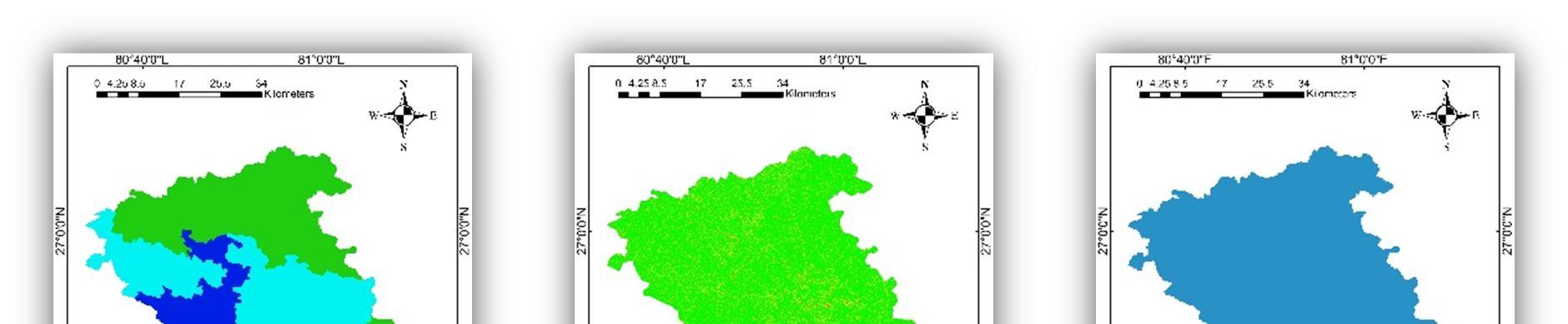
Due to its substantial influence upon groundwater recharge, which is a major pathway for pollutants to travel down the ward, soil media directly influences the passage of contaminants from the surface to the phreatic level. The permeability capacity of the soil, which depends on soil texture, directly regulates the quantity and pace of recharge. Silt and clay are examples of smaller textured materials with less permeability, which limits the passage of polluting materials. So, the higher rate has been assigned to the larger textured soil and the lower rate has been given to the smaller textured soil (Aller et al. 1987). Three types of soils are prevalent in the district: Sandy Loam, Silty Loam and Loam (CGWB 2020). The soil media map presented in Fig. 3(d) was prepared by assigning appropriate ratings to the soil types as shown in Table 1.
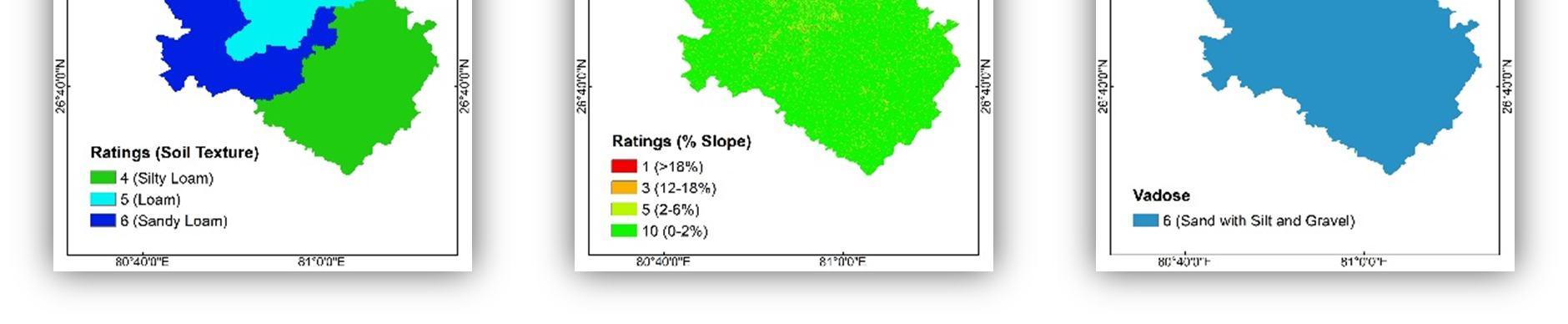
Topography indicates the percent of slope. One of the most important topographic elements that affects the rate of infiltration and water level recharge is slope. There is an inverse relationship between the slope angle and the infiltration rate. Low sloped locations retain water for a longer length of time, allowing for increased infiltration rates and pollutant flow possibilities. On the other, steep slope experienced considerable runoff and little change of infiltration and groundwater contamination. So, the lower rate has been assigned to the steep slope and the higher rate to the areas of low slope (Aller et al. 1987). The topography details (Fig. 3(e)) were obtained from the digital elevation model (source: USGS earth explorer) of the study area. By using the Spatial Analyst Tool of ArcGIS, slope values were calculated from the topographic elevations. The slope values were rated according to the standardized 1 10 scale, with 1 and 10 being the lowest and highest slopes, respectively (Table 1).
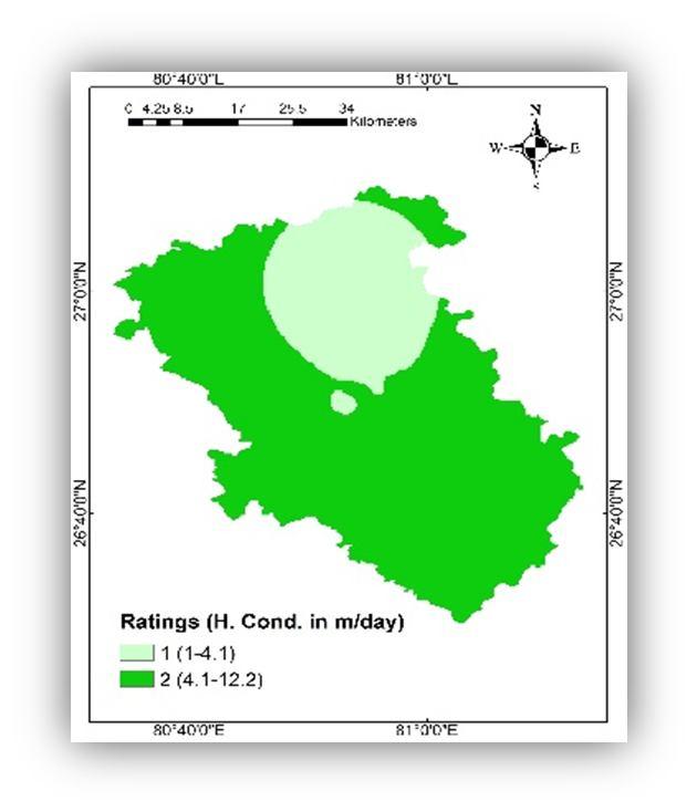
From the surface of the earth to the top of the phreatic zone, there is an unsaturated zone known as the vadose zone. Similar to soil type, it has an impact on the possibility for aquifer vulnerability. The likelihood of groundwater pollution is mostly influenced by its thickness, permeability, and particle size. Compared to the impermeable layer, the permeable vadose layer has a greater influence on the movement of contaminants. The vadose zone of the study area is sand with silt and gravel (CGWB 2020). So the permeable layers have been given higher ratings than the impermeable layer (Aller et al. 1987). The impact of vadose zone map (Fig. 3(f)) was prepared according to the rating ranges of the parameters (Table 1).
The capacity of a substance to flow fluid through pores and fractured rocks is known as hydraulic conductivity, which depend on the types of soils of that region. There is a direct relationship between hydraulic conductivity and the potentiality of contamination. High hydraulic conductivity aquifers are more likely to be the source of contaminated material flow. Based on the pumping test data (CGWB 2020), of boreholes, hydraulic conductivity was used to prepare the spatial map of hydraulic conductivity and it was divided in two different classes (1 4.1) and (4.1 12.2). The rating for these classes was given according to the Table.1. The map is shown in Fig. 3(g).
ISSN: 2321 9653; IC Value: 45.98; SJ Impact Factor: 7.538 Volume 10 Issue X Oct 2022 Available at www.ijraset.com
(d) (e) (f) (g)
Fig. 3. (a) Depth to water, (b) Net Recharge, (c) Aquifer Media, (d) Soil Texture, (e) Topography, (f) Impact of vadose zone, (g) Hydraulic Conductivity
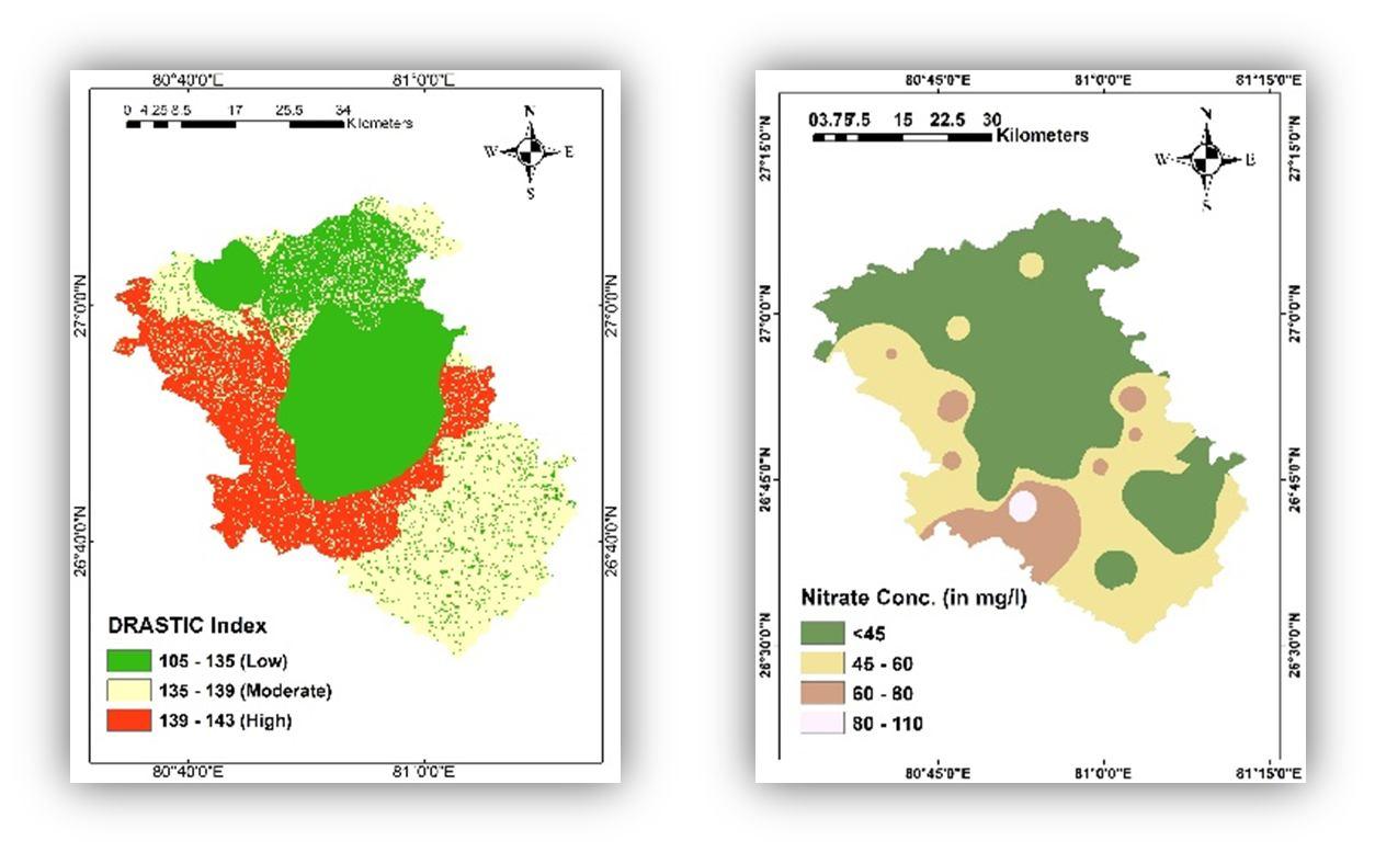
The DRASTIC Index map is created based on the various processes outlined above. The DRASTIC risk map showed three vulnerable classes i.e. low, medium, and high vulnerable classes on the basis of the DRASTIC index. The DRASTIC index is evaluated using Eq. (1) and resulted intrinsic vulnerability map represented in Fig. 4(a) The estimated DRASTIC index map illustrates the current level of vulnerability in this research area. It was categorized into three vulnerability classes: low (105 135), moderate (135 139), and high (139 143). Mal and Sarojani Nagar Block showed higher vulnerability is (139 143). The results also suggested that the low, moderate, and high groundwater vulnerability zones cover around 30.35, 45.02, and 24.63 % of the study area, respectively.
The water quality parameter Nitrate (NO3) is used to validate the DRASTIC model in this study. In most of the cases, nitrate does not have a natural source in the groundwater system. Hence, its presence in the groundwater system indicates a contamination source such as agricultural and anthropogenic activities. IS 10500 suggests the permissible limit for Nitrate (NO3) is 45 mg/l. for validating it 32 samples of groundwater from different location is taken and tested in the lab. A spatial map of Nitrate contamination for these samples is made using ArcGIS as shown in fig. 4(b). The map is divided in four classes (<45 mg/l, 45 60 mg/l, 60 80 mg/l, 80 110 mg/l). The percentage of study area for the classes <45 mg/l, 45 60 mg/l, 60 80 mg/l, and 80 110 mg/l are 55.5%, 34.5%, 9%, and ~1% respectively.
ISSN: 2321 9653; IC Value: 45.98; SJ Impact Factor: 7.538 Volume 10 Issue X Oct 2022 Available at www.ijraset.com

(a) (b) Fig. 4 (a) Drastic Index, (b) Nitrate Concentration
DRASTIC Index NitrateConcentration
n = 32 Pearson’s Coefficient, r = 0.85
R² = 0.723 0 20 40 60 80 100 120 140 160 0 20 40 60 80 100 120
Fig. 5. Plot between DRASTIC index (DI) and nitrate concentration (mg/l)
The study aims to evaluate the susceptibility of the aquifer in Lucknow, India. The task is accomplished by using the GIS Based DRASTIC model. Based on the result, the vulnerable zones are classified into three zones namely low, moderate and high vulnerable zones. The study has shown that 30.35 % of the total area was under the low vulnerable zone, mainly due to the presence of the higher depth of water level. About 24.63 % of the area is under high vulnerable zone which could be due to the reason of Shallow depth of water table, and permeable vadose zone. The model is validated using Nitrate contamination which shows that about 55 % area is under the permissible limit and the remaining area shows more than the permissible limit in which about 1% area is at high risk. Thus, the study has demonstrated that the DRASTIC Model is a useful tool for identifying the groundwater contamination risk zone, allowing for the development of efficient strategies for groundwater management and protection.
The author thanks Asst. Prof. Anirudh Gupta, CED, IET Lucknow for his holistic support and Ecomen Laboratories Pvt. Ltd. Lucknow for providing essential facilities for completing this study. Thanks are also extended to CGWB, UP Jal Nigam, Lucknow, for providing all necessary data.
ISSN: 2321 9653; IC Value: 45.98; SJ Impact Factor: 7.538 Volume 10 Issue X Oct 2022 Available at www.ijraset.com
[1] Rahman, M., Haque, M. M., & Tareq, S. M. (2021). Appraisal of groundwater vulnerability in south central part of Bangladesh using DRASTIC model: An approach towards groundwater protection and health safety. Environmental Challenges, 5, 100391.
[2] Ghosh, R., Sutradhar, S., Mondal, P., & Das, N. (2021). Application of DRASTIC model for assessing groundwater vulnerability: a study on Birbhum district, West Bengal, India. Modeling Earth Systems and Environment, 7(2), 1225 1239.
[3] Ghosh, A., Tiwari, A. K., & Das, S. (2015). A GIS based DRASTIC model for assessing groundwater vulnerability of Katri Watershed, Dhanbad, India. Modeling Earth Systems and Environment, 1(3), 1 14
[4] Pacheco, F. A. L., Pires, L. M. G. R., Santos, R. M. B., & Fernandes, L. S. (2015). Factor weighting in DRASTIC modeling. Science of the Total Environment, 505, 474 486.
[5] Selvam, S., Venkatramanan, S., & Chung, S. Y. (2016). Identification of groundwater contamination sources in Dindugal district of Tamil Nadu, India using GIS and multivariate statistical analyses. Arabian Journal of Geosciences, 9(5), 1 14.
[6] Ahmed, A. A. (2009). Using generic and pesticide DRASTIC GIS based models for vulnerability assessment of the Quaternary aquifer at Sohag, Egypt. Hydrogeology Journal, 17(5), 1203 1217
[7] Aller, L., Bennett, T., Lehr, J., Petty, R. J., & Hackett, G. (1987). DRASTIC: A standardized system for evaluating ground water pollution potential using hydrogeologic settings. US Environmental Protection Agency. Washington, DC, 455
[8] Kazakis, N., & Voudouris, K. S. (2015). Groundwater vulnerability and pollution risk assessment of porous aquifers to nitrate: Modifying the DRASTIC method using quantitative parameters. Journal of Hydrology, 525, 13 25.
[9] Rahman, A., 2008. A GIS based DRASTIC model for assessing groundwater vulnerability in shallow aquifer in Aligarh, India. Appl. Geogr 28, 32 53.
[10] Neshat, A., Pradhan, B., Pirasteh, S., & Shafri, H. Z. M. (2014). Estimating groundwater vulnerability to pollution using a modified DRASTIC model in the Kerman agricultural area, Iran. Environmental earth sciences, 71(7), 3119 3131.
[11] Alam, F., Umar, R., Ahmed, S., & Dar, F. A. (2014). A new model (DRASTIC LU) for evaluating groundwater vulnerability in parts of central Ganga Plain, India. Arabian Journal of Geosciences, 7(3), 927 937.
[12] Shirazi, S. M., Imran, H. M., Akib, S., Yusop, Z., & Harun, Z. B. (2013). Groundwater vulnerability assessment in the Melaka State of Malaysia using DRASTIC and GIS techniques. Environmental earth sciences, 70(5), 2293 2304.
[13] Yin, L., Zhang, E., Wang, X., Wenninger, J., Dong, J., Guo, L., & Huang, J. (2013). A GIS based DRASTIC model for assessing groundwater vulnerability in the Ordos Plateau, China. Environmental earth sciences, 69(1), 171 185.